Article

Geochemistry of Weathering Cover and the Main Influencing Factors in Karst Area of Guilin, Southwest China

1
Institute of Karst Geology, Chinese Academy of Geological Sciences, Guilin 541004, China
2
Key Laboratory of Karst Dynamics, Ministry of Natural Resources & Guangxi Zhuang Autonomous Region, Guilin 541004, China
*
Author to whom correspondence should be addressed.
Water 2023, 15(16), 2944; https://doi.org/10.3390/w15162944
Submission received: 30 May 2023 / Revised: 30 July 2023 / Accepted: 4 August 2023 / Published: 15 August 2023
(This article belongs to the Special Issue Karst Dynamic System and Its Water Resources Environmental Effects)

Abstract

:
The chemical weathering of carbonate rocks is the main form of interaction between earth spheres in the karst critical zone. The karst weathering cover, which is composed by residua from carbonate rocks weathering, contains important information about the climate environment and material cycle. We present the chemical composition of weathering covers in karst area of Guilin, Guangxi province, analyze their weathering process and strength, and compare them with the other weathering covers in other karst area in China, including Yunnan, Guizhou, Hunan, and Qinghai Tibet Plateau. The results showed: (1) the chemical composition of Guilin weathering covers were similar to that of carbonate weathering covers in other areas of China, and had the common characteristics of uniform distribution of chemical composition in the profile and obvious enrichment of Fe, Al and trace elements. During the formation of carbonate weathering cover and the residua, the rapid dissolution of Ca and Mg had an important impact on the migration and enrichment of other elements. (2) The chemical index of alteration (CIA) of carbonate weathering covers in Guilin and other karst areas of China was much larger than that in the upper crust (UCC) (60.13), which showed strong chemical weathering characteristics of the humid and hot climate. (3) The weathering process of carbonate rock was different from that of silicate and loess. In the early stage of carbonate rock weathering, soluble components (calcite and dolomite) had been rapidly dissolved and leached. All the carbonate weathering residua was measured to be in the stage of K2O weathering and Al2O3 increasing. Therefore, the weathering degree of carbonate weathering cover was mainly determined by the leaching of K2O and the increase of Al2O3. As a result, there was no correlation between CIA and Na/K (molar ratio), but was a significant negative correlation between CIA and K/Al (molar ratio) in the carbonate weathering cover. (4) The CIA values of weathering residua and carbonate weathering cover in southern China were negatively correlated with latitude, reflecting the influence of climate factors. From the influence of lithology, the chemical compositions of parent rock can affect the CIA of weathering cover, and the content of insoluble matter in carbonate rock was negatively correlated with CIA. From the influence of topography, the CIA value of weathering residua decreased from the high to the low position and from the shallow to the deep part of the profile.

1. Introduction

The chemical weathering of rocks is an important manifestation of the interaction between various spheres on the surface. It not only provides mineral nutrients for terrestrial ecosystems [1,2], but also affects global climate change [3,4], the surface material cycle [5], and the chemical composition of water. Weathering materials also contain important geological information, such as continental weathering, erosion, and environment [6]. Since the beginning of the Cenozoic era, Hunan-Guangxi hills and Yunnan-Guizhou Plateau have been in a continental environment where the red karst weathering cover is widely distributed [7,8]. Weathering covers form by limestone weathering, and accumulation is widely distributed in karst areas [9], which are listed as regosol class or primary soil class. The classification of soil genesis indicated that red residua overlying limestone belongs to a carbonate weathering cover, and its development degree is lower than that of yellow soil and red soil [10]. The study on the genesis and chemical composition of karst weathering covers is significant for understanding the material cycle characteristics of the karst area, analyzing the factors restricting the weathering process of carbonate rock, and revealing the geomorphic evolution and environmental change process in the karst area. Scholars have carried out a lot of studies on the formation age of karst weathering covers [11], discrimination of material sources [12,13,14,15,16], weathering and soil forming process [17], the migration of elements [18], and the accumulation of heavy metals [19,20,21,22,23]. The research showed that red weathering covers and red residua distributed in the karst area were the products of carbonate rock weathering, which is restricted by the chemical weathering of carbonate rock. Carbonate weathering covers and red residua showed different characteristics from other red weathering coves, such as the weathering cover composed of red soil, lateritic soil, and yellow red soil [24,25]. First, the carbonate weathering cover was thin and uneven. In addition, the formation and accumulation of carbonate weathering covers need the dissolution of very thick carbonate rock [26,27]. Second, there was no transition layer between carbonate rock and weathering cover [28]. Third, the carbonate weathering cover had higher clay content, stronger chemical weathering, and weaker desilication and aluminum enrichment than other red weathering covers. Fourth, the weathering cover of carbonate rock was generally rich in trace elements, making the karst area a high background value area for trace elements [29]. However, most of these studies were carried out in the karst areas of the Yunnan-Guizhou Plateau, and the research in Guangxi province, where the carbonate rock weathering cover is widely distributed, is lacking. What is the difference and relation between karst weathering residua overlying limestone in Guangxi and the weathering cover in other carbonate rock areas? In this paper, typical weathering residua/covers in Guilin, Guangxi are selected to study their chemical composition and distribution characteristics, and we compared them with the carbonate weathering covers in other carbonate rock areas. The study will help us to understand the karst weathering residua forming process, influencing factors, and the law of element migration and enrichment.

2. Materials and Methods

2.1. Study Area

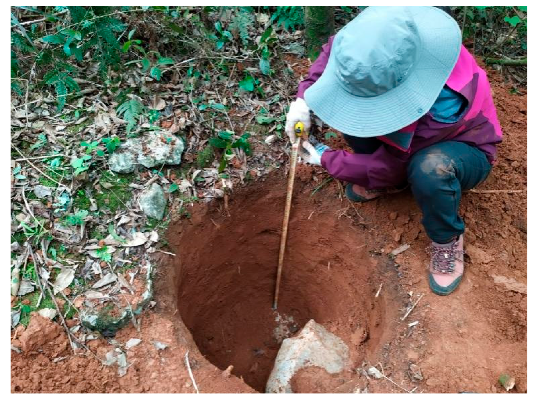
This study was carried out in Guilin Yaji experimental site and Zhaidi research site (Figure 1 and Figure 2). Yaji experimental site is located in the southeast suburb of Guilin, Guangxi, 8 km away from the urban area and at the junction of the peak cluster depression and peak forest plain. Yaji experimental field is a typical karst spring system, where consist of several epikarst springs. The spring area is composed of base-connected peaks and depressions, and the surface and underground karst features are developed. The elevation of the highest peak in the experimental field is 652 m, the elevation range of depressions is 250–400 m, and the elevation of karst plain is 150 m. The Upper Devonian Rongxian Formation (D3r) limestone is mainly exposed in the site, which is a light gray to gray–white dense medium–thick layered micritic limestone, with dig to 135°, dip angle ranged from 5° to 10°, and a total thickness of 387 m. In the site area, brown and red residua are developed, and the thickness of the residua is uneven, and the distribution is not continuous. The rocks at the top of the mountains are exposed, the thickness of the hillside weathering cover is 10–100 cm, and the thickness of the weathering cover in depression is 80–300 cm. Due to the strong spatial heterogeneity of weathering cover in the karst area of southern China, we selected a slope in the experimental field; dug the profiles at the upper (Y3), middle (Y2), and lower of the slope (Y1) (Scheme 1); shoveled off the surface soil; and collected weathering residua samples every 20 cm from top to bottom of the profiles, and we collected the underlying rock samples of each profile. The depths of profile Y1, Y2, and Y3 are 100 cm, 120 cm, and 100 cm, respectively. Therefore, we collected 5, 6, and 5 residua samples in profile Y1, Y2, and Y3 respectively. In total, 16 residua samples and one rock sample were collected at Yaji experimental field.
Research site of Zhaidi, Guilin is located on the southern foot of the Haiyang mountainous, 31 km away from Guilin city. A karst underground river system composed of multiple pipelines is developed in Zhaidi, with a catchment area of 33.5 km2. The aquifer group in the system is mainly Devonian Dongcun formation (D3d) medium–thick limestone. The site is generally monoclinal structure where several faults with NNE–SSW strike direction are developed. The main geomorphic type is peak cluster depression. Brown and red weathering residua are developed in the site, with extremely uneven thickness and discontinuous distribution. The rocks at the top of the mountains are exposed, and the weathering residua thickness is generally 30–150 cm. The thickness of weathering residua in the depression is large, up to several meters. We selected a slope in the recharge area on the east side of the system; dug a profile on the upper slope (Z3), the middle slope (Z2), and in the depression (Z1), respectively; shoveled off the surface soil; and then collected weathering residua samples every 20 cm from top to bottom, and we collected the rock samples underlying the profile. The depths of profile Z1, Z2, Z3 are all 100 cm. Therefore, we collected 5 residua samples in each profile, and a total of 15 residua samples and 1 limestone sample were collected in Zhaidi site.

2.2. Sampling and Testing

The thicknesses of the six profiles were 100–120 cm, their stratifications are not obvious, and there is no hard weathering layer, i.e., transition layer between the weathering residua layer and the bedrock. According to the color of residua layer, the profiles were divided into layers A, AB, and B. Layer A was dark and rich in organic matter (1.95–7.53%); Layer AB was brown-yellow, and the organic matter decreased rapidly. This layer was rich in limestone breccia in the lower parts of hillside. Layer B was a sedimentary layer, rich in iron and aluminum oxides, relatively hard, and brown–red.
We ground the samples to 200 meshes after natural air drying, put them in a dry environment, reserved backup samples, and took several sufficient samples to test and analyzed major and trace elements, respectively. The test was completed in the Karst Geology and Resource Environment Test Center. The main elements were tested by X-ray fluorescence spectrometry (XRF). The analytical concentration range was 10−9~10−2, and the test standard error was less than 10%. Trace elements were tested with a high-resolution inductively coupled plasma mass spectrometer (hr-icp-mas, element XR). The analytical accuracy was better than 1~3%, the detection limit was generally less than 5 × 10⁻¹², and the test standard error was less than 10%.

3. Results and Discussion

3.1. Chemical Composition and Distribution Characteristics of Guilin Weathering Cover

Table 1 shows the major chemical composition data of profile of Yaji and Zhaidi site in Guilin and the average chemical composition of the carbonate weathering cover in other karst area in China, including Qinghai-Tibet Plateau, Shangri-La county of Yunnan province, Southern Liaoning province, Jishou city of Hunan province, Xinpu in northern Guizhou province, Zhenan county of Shanxi province, and Dao county of Hunan province.
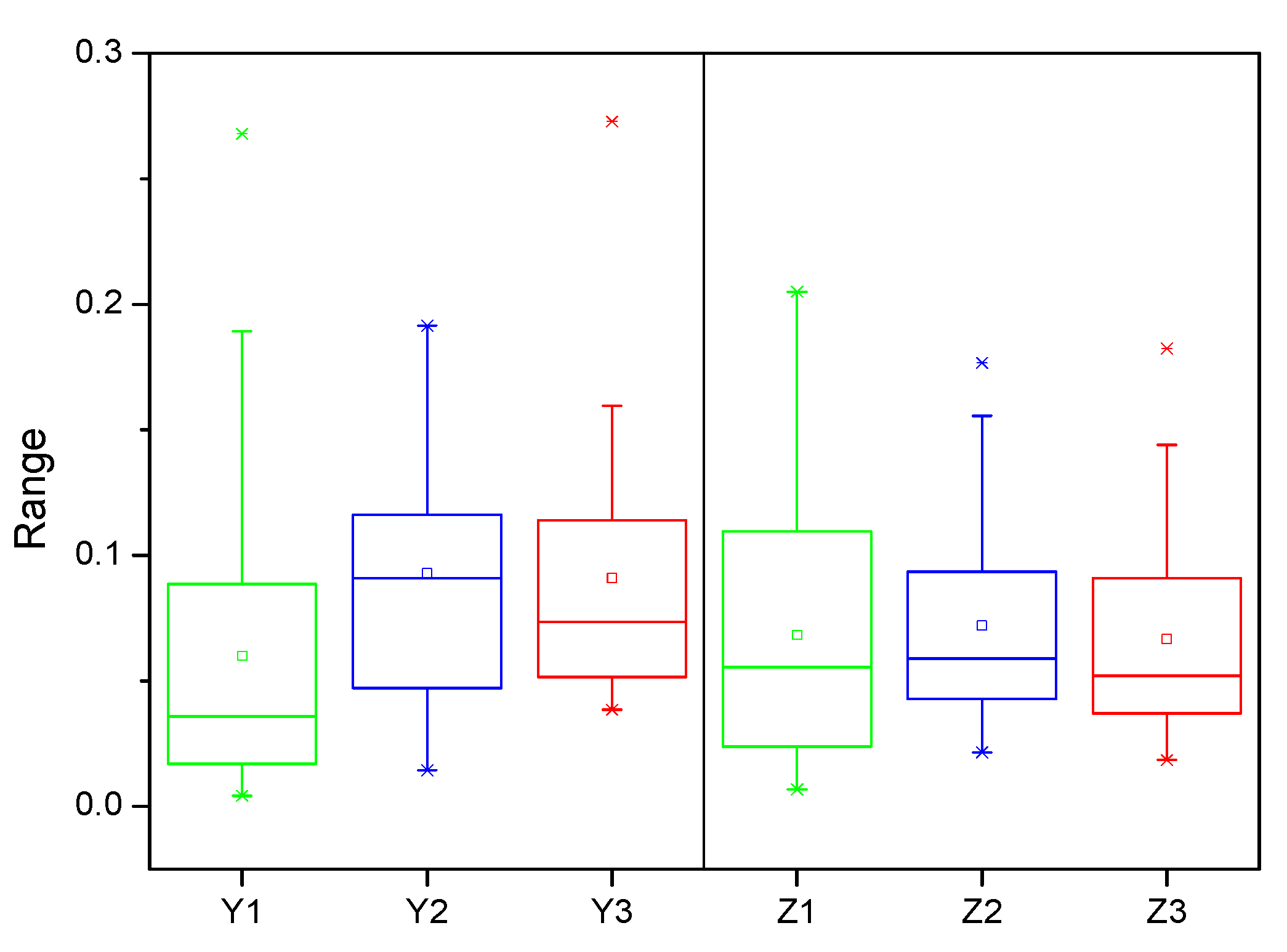
The main composition of weathering covers in Yaji and Zhaidi of Guilin are SiO2, Al2O3, and Fe2O3. The SiO2 content of Zhaidi profiles is high and the Al2O3 content is low, showing a weaker desilication and aluminum enrichment effect than Yaji site. The coefficient of variation (CV) of elements in each profile of Yaji and Zhaidi was counted and drawn into a boxplot (Figure 3). As shown in the figure, the CV values of elements in most profiles were less than 0.2, and the average value and median value of CV were less than 0.1. This indicated that the chemical compositions were evenly distributed in the profiles. Moreover the CV values of SiO2, Al2O3, and Fe2O3 were smaller than other chemical composition. The reason may be that SiO2, Al2O3, and Fe2O3 are the main components of “insoluble matter” of carbonate rocks. Overall, the variation of chemical components in the profiles is small in the two sites, which is consistent with the feature of carbonate weathering covers in other parts of China. Distribution of chemical composition on the profile trend to be uniform is a common feature of carbonate weathering covers in China, which is determined by the diagenesis and weathering process of carbonate rocks. In the stage of carbonate rock formation, since carbonate rock formed in the shallow sea by chemical deposition, insoluble matter that had a wide origin naturally underwent a series of processes, such as transportation, sorting, mixing, and deposition, before they were added and deposited into the carbonate rock. In the stage of carbonate rock weathering and karst residua formation [33], it took about 100 m pure carbonate rocks to form weathering residua of 1 cm thickness due to low content of insoluble matter in carbonate rock. The content of insoluble matter is only 0.41–10.66% through the analysis of the chemical composition of carbonate rocks of different geological ages in the main karst areas of China. There is also mixing in the process of dissolution and residua of carbonate rocks, especially for those pure carbonate rocks. Therefore, the mixing effect of diagenesis and weathering and soil forming process makes the uniform distribution of “insoluble matter” and its elements in the profile.

3.2. Normalization against Average UCC for the Elements in GUILIN Karst Weathering Cover and the Comparation with Other Karst Area

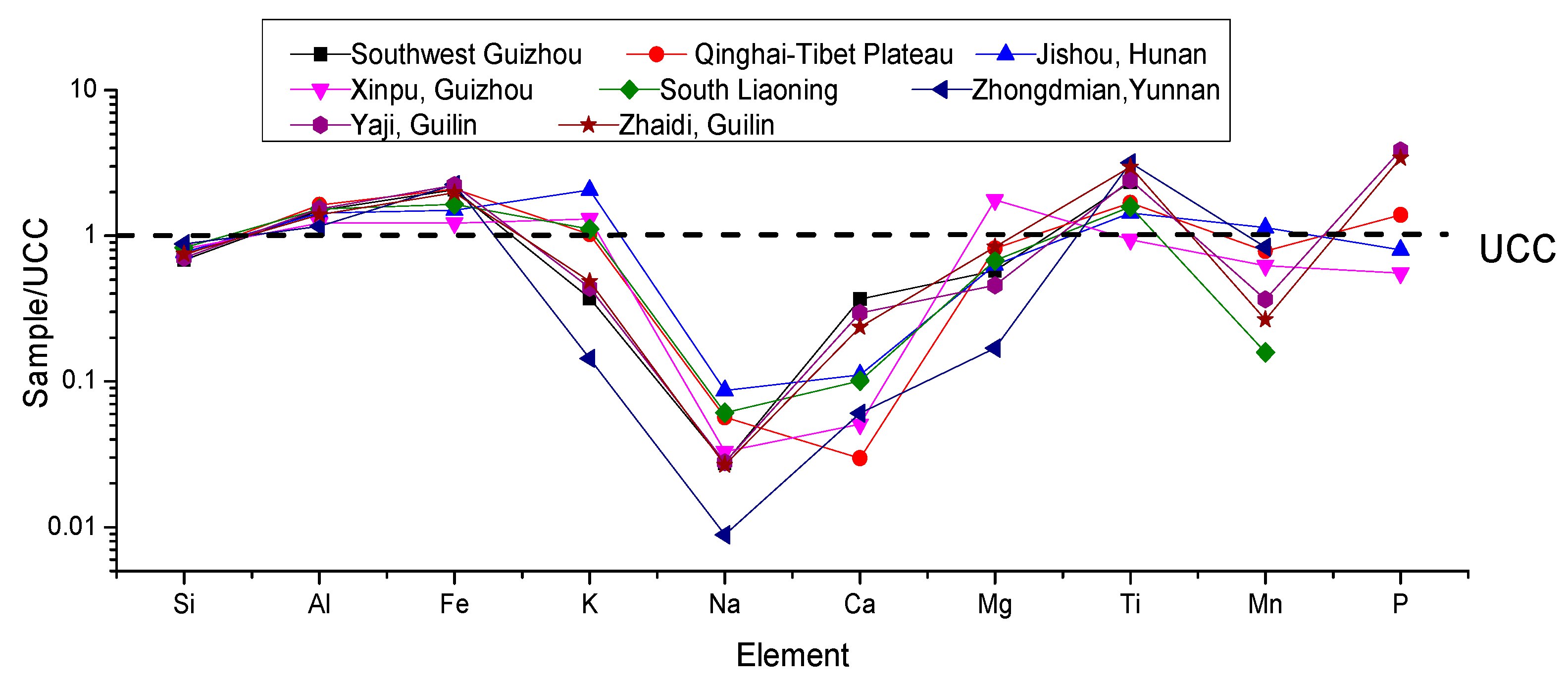
Normalization against average upper continental crust (UCC) for major elements in Guilin weathering cover profiles were plotted in Figure 4. We found that the chemical composition of Guilin weathering cover was similar to that of carbonate weathering covers in other karst area of China. Among these weathering covers, the UCC standard values of the three main components, SiO2, Al2O3, and Fe2O3, were much closer. The difference of UCC standard values was small for TiO2, a stable component, while larger for K2O, Na2O, CaO, MgO, MnO, and P2O5, among these weathering covers. Moreover, the content of CaO showed an increasing trend from Qinghai-Tibet Plateau to Yunnan-Guizhou Plateau then to Guangxi hills and from south Liaoning to Hunan then to Guangxi. The reason may relate to the increment of secondary CaCO3 in residua caused by carbonate dissolution and precipitation. In general, compared with the average value of elements in the upper continental crust (UCC), the leaching losses of Na and Ca in carbonate weathering covers were the strongest. The leaching loss of K, Mg, and Mn were strong. Ti was slightly enriched, and Si, Al, and Fe were closed to the average value of UCC.
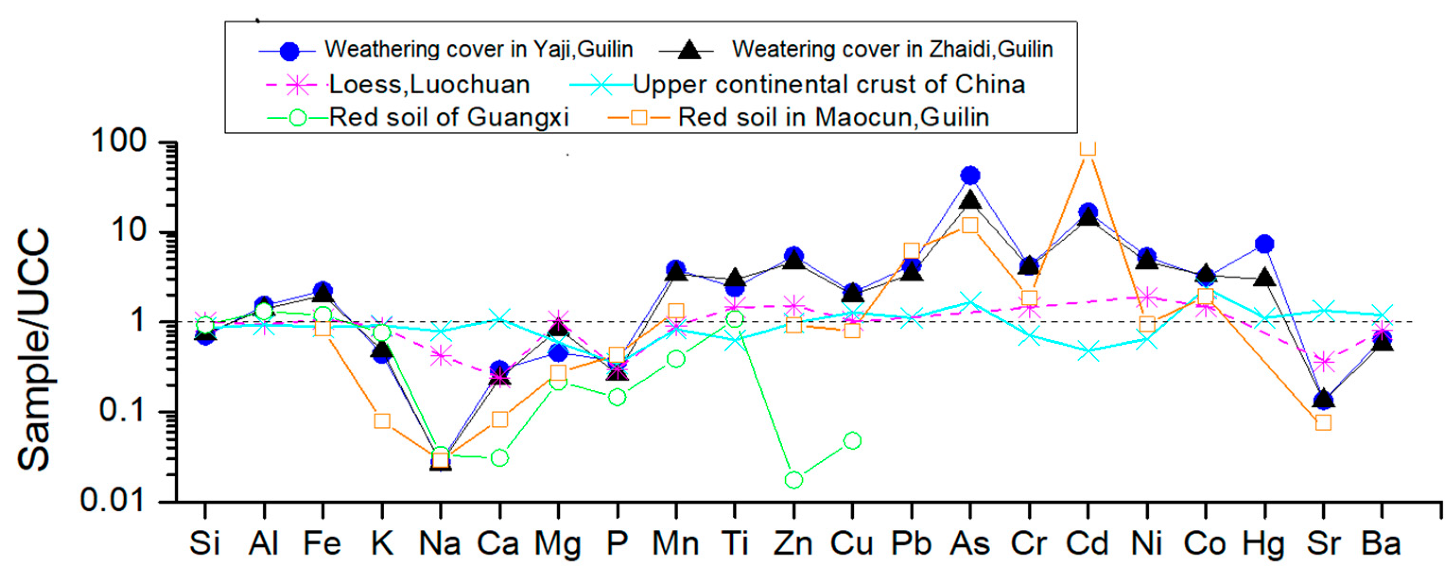
We compare the major and trace elements content among Guilin weathering cover profiles, loess profiles, red soil profiles, and Chinese continental crust via normalization against the UCC average (Figure 5). As shown in the figure, the curves of Yaji profiles and Zhaidi profiles almost coincide, which means that the contents of major and trace elements in the two sites were very close. Guilin is located in the middle subtropical zone, where zonal soil is red soil. Compared with the red soil formed by the weathering of clastic rock, the element distribution curve of Guilin karst weathering covers were similar, indicating that chemical composition of the two type of profiles were both affected by the same climatic conditions. The difference between this two types of profiles was that the content of most elements in karst weathering covers were higher than that in Guilin red soil, implying the enrichment degree of most elements in karst weathering covers were stronger than that in red soil while the activity of most elements were stronger in red soil than karst weathering covers. The activity of Zn and Cu of red soil was strong in Nanning, where it was located to the south of Guilin, with higher humidity and temperature. The content of major elements (Ca, Mg, P, Mn, and Ti) in Nanning red soil were significantly lower than that of karst weathering covers and Guilin red soil. Most of the elements’ activity in Nanning red soil was larger than that of other profiles, which accords with the evolution law of soil. With the increase of temperature and humidity, the red soil shows a trend of increasing desilication, iron and aluminum enrichment, and element activity from north to south, and the red soil gradually transits to laterite and then evolves into latosol. In addition, the UCC standard values of Na in karst weathering covers and red soil in Guangxi are highly consistent, which may indicate that Na in the soil of Guangxi generally migrates rapidly and is fully leached, which is related to the solubility of Na and the humid and hot climate in Guangxi. The content of Ca and Mg in Guilin karst weathering covers are higher than that in red soil, which is affected by the geological background of rich calcium and magnesium in the karst weathering cover.
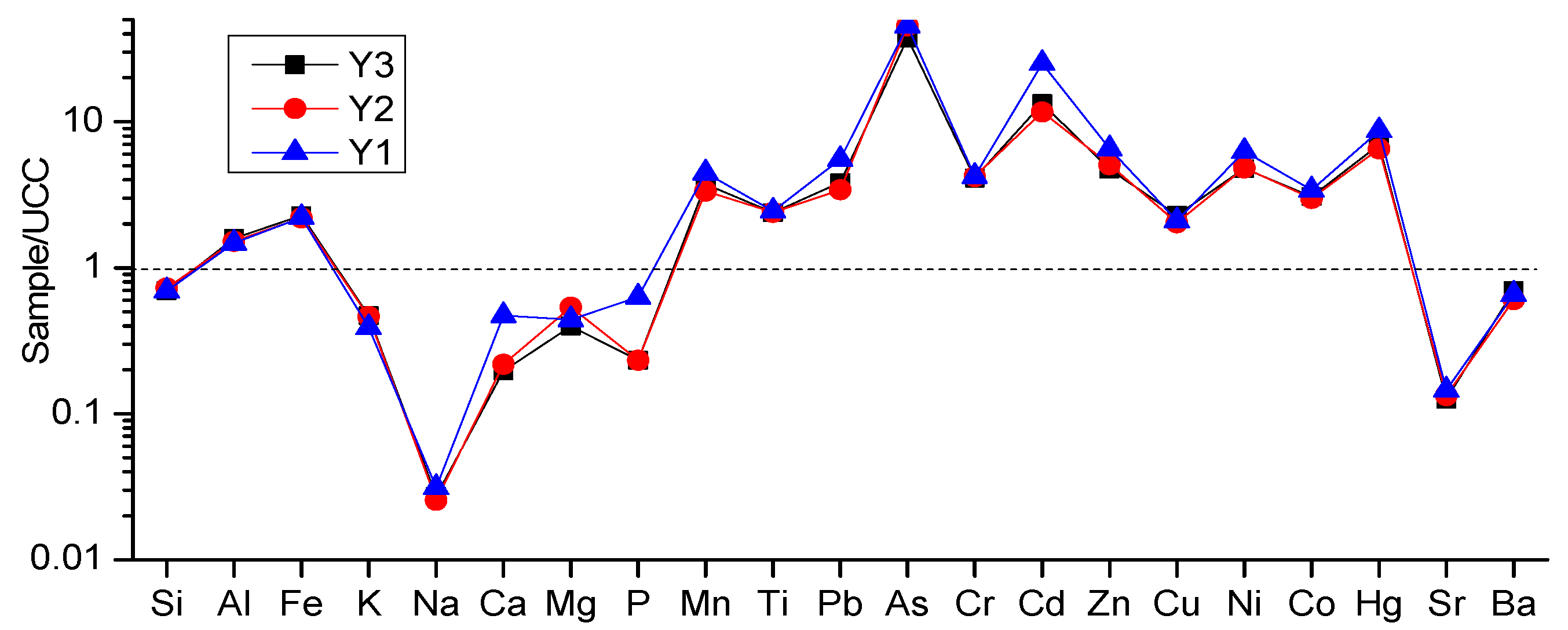
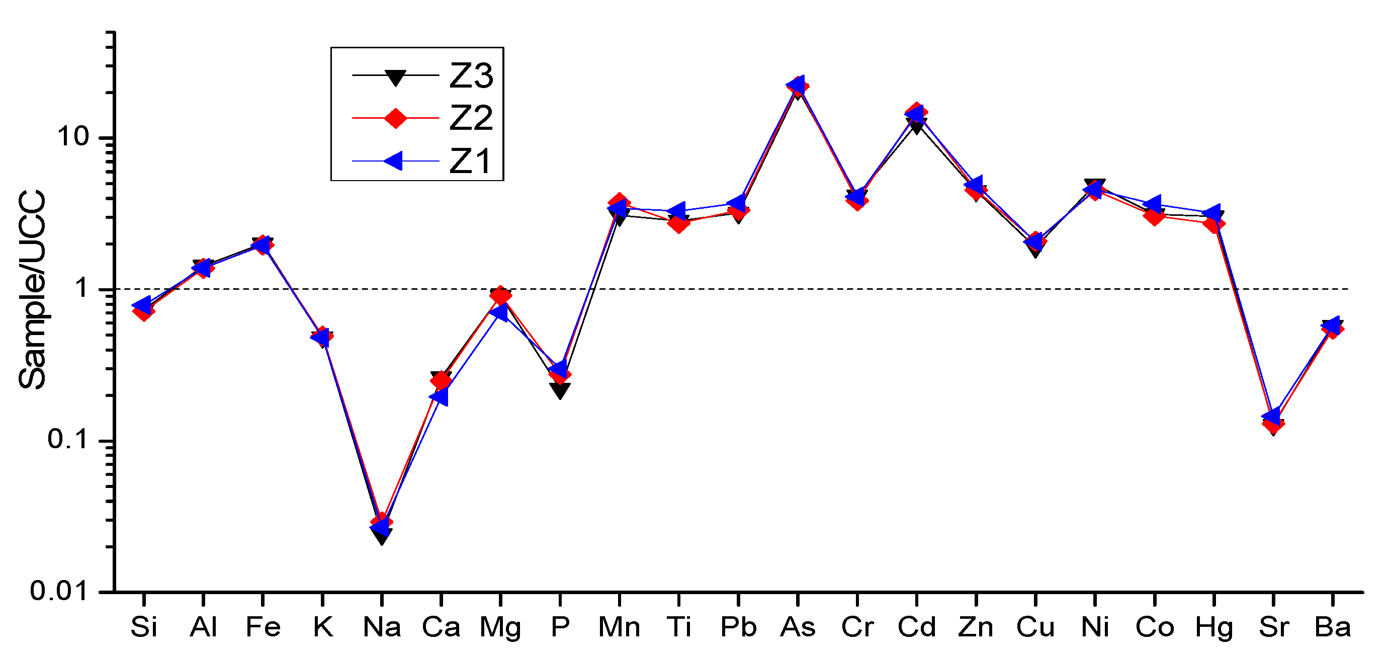
The undulation shapes of the Guilin karst weathering covers’ curves were similar to that of the loess curve, but the amplitude was different (Figure 6 and Figure 7). As mentioned earlier, karst weathering cover is formed by the residual and further weathering of insoluble matter in carbonate rock. The source of “insoluble matter” has a broad regional background and can represent the average chemical composition of the upper continental crust in a certain region during the formation period of carbonate rock [33]. This feature is similar to loess. Taylor Sr (1983) [37] found that the mineral composition of “insoluble matter” in dolomite was similar to that of typical loess (illite, quartz, mica, etc.). Cao Wanjie (2012) [38] found through a rare earth element analysis that the element composition of carbonate weathering covers in Bijie, Guizhou was close to loess and UCC while the element composition of silicate weathering covers deviated greatly from them. The composition of loess was more similar to the UCC than that of karst weathering cover. The reason was due to their formation process. First, loess was of aeolian origin and has a wider material source. Second, it may reflect the difference in weathering intensity under different climatic conditions. Loess is distributed in Northwest China. The climate there is dry and cold, leading to low weathering strength and closer curve of element content to the UCC. While the weather in Guilin, Southwest China is hot and humid, which cause a strong weathering effect, and high element migration and enrichment intensity. Thus, the element content curve of karst weathering cover deviated more from the average of UCC. The difference of element curve of China’s continental crust to that of Guilin karst weathering cover and loess may be caused by weathering effect from other rocks.
Compared to the UCC, many elements, including Na, CA, Sr, K, Mg, and P, in Guilin karst weathering covers were leached. Two elements (Si and Ba) were weakly leached while heavy elements, such as Cd, Hg, Ni, Cr, Mn, and Zn, were obviously enriched. The Ca content of Yaji was higher than that of Zhaidi; the enrichment of Al, Zn, As, Hg, and other elements were slightly higher than that of Zhaidi; and most trace and heavy metal elements were slightly higher than that of Zhaidi profiles. These results showed that the enrichment of trace and heavy metals elements in karst weathering cover was related to the increase of Ca content. The increased Ca content mainly came from secondary depositions in weathering covers [39]. Accordingly, the enrichment of trace and heavy metal elements may be related to the content of secondary CaCO3 in weathering covers.

3.3. Chemical Weathering Intensity

3.3.1. CIA Index

The chemical index of alteration (CIA) is widely used to measure the intensity of chemical weathering.
CIA = [Al2O3/(Al2O3 + CaO* + K2O + Na2O)] × 100
where the chemical formula represents the moles of oxide molecules, where CaO* is the molar content in silicate minerals, excluding the CaO content in carbonate and phosphate. Because CaO and Na2O in silicate usually exist in the ratio of 1:1, when the molar number of CaO is greater than Na2O, it can be considered that mCaO* = mNa2O, and when the molar number of CaO is less than Na2O, mCaO* = mCaO.
Generally, a CIA value between 50 and 65 reflects a low degree of chemical weathering under cold and dry climate conditions; a CIA value between 65 and 85 reflects the moderate degree of chemical weathering under warm and humid conditions; a CIA value between 85 and 100 reflects the intense degree of chemical weathering under hot and humid tropical and subtropical conditions.
The CIA of Yaji weathering covers was ranged from 91.18 to 93.07 (Table 1), with an average of 92.12. The CIA of Zhaidi weathering cover was between 89.96~91.92, with an average of 90.80. For one thing, the CIA of karst weathering covers at Yaji and Zhaidi were close, as the climate, the latitude, and the pedogenic bedrock are similar in these two sites. The bedrocks of these two sites are both limestone. For another thing, the CIA of weathering cover in Yaji site was slightly higher than the Zhaidi site, and these little difference may be caused by the difference of chemical composition of the parent rock (Table 2) and the landform between the two sites.
In terms of the impact of landform, we found CIA generally decreased from up to low of the slope and from shallow to deep in the profiles (Table 3), reflecting a weakening trend of weathering intensity. The main reason is that the water circulation condition at the high place of the slope is good, and the soil water and groundwater runoff speed is fast, leading to stronger chemistry weathering of the weathering cover [40,41].
The CIA of Guilin weathering cover was compared with other typical carbonate weathering covers in China. We found that the CIA of Guilin weathering cover were smaller than that of the limestone weathering cover of Dahua in Guangxi province (97.36) and Kunming in Yunnan province (94.21), equivalent to that of the limestone weathering cover of Xingyi in Guizhou province (92.91), and slightly higher than that of dolomite weathering cover (91.44) of Pingba in Guizhou province. The CIA values of weathering covers in the above areas Guilin, Dahua Guangxi, Kunming Yunnan, Pingba, and Xingyi Guizhou are all greater than 90, showing strong weathering. These areas are all located in low latitude areas with a hot and humid climate and have been subjected to strong chemical weathering during the process of weathering and soil formation. The CIA value of carbonate paleo weathering cover in Qinghai-Tibet Plateau is 81.12–89.19, smaller than those of Guizhou, Guangxi, and other places, but it also reflects the humid and hot climate conditions. In addition to the similar CIA, the chemical composition and the weathering index values of SiO2/Al2O3, SiO2/(Fe2O3 + Al2O3), K2O/Na2O, (K2O + Na2O + CaO)/Al2O3 of carbonate weathering cover in Qinghai-Tibet Plateau, Yunnan-Guizhou Plateau, and Guangxi are relatively close, and their mineral assemblages are similar (mainly illite and kaolin) [31].
The CIA values of weathering cover in Guizhou, Yunnan, and Qinghai Tibet Plateaus do not match their rainfall and temperature conditions. Especially in the Qinghai-Tibet Plateau, the climate is dry and cold. The CIA value of weathering covers formed based on the current climate conditions should be low. Previous studies believe that the neotectonic uplift had not started when the carbonate weathering cover was formed. Before the neotectonic uplift, Tibet, Qinghai, Guizhou, Yunnan, Guangxi province were located in low latitude and low altitude areas with tropical, hot and humid environment. In summary, the chemical weathering intensity of carbonate weathering cover in Guilin, Guizhou, Yunnan, and the Qinghai Tibet Plateau is much greater than that in the upper crust (UCC, with an average CIA value of 60.13), exhibiting strong chemical weathering characteristics in humid and hot climate environments.

3.3.2. Na/K, K/Al Ratio

Na/K ratio (molecular molar ratio) is an index to measure the weathering degree of plagioclase in a soil or sediment sample. The weathering rate of plagioclase is much higher than that of potassium feldspar. In addition, feldspar, especially plagioclase, is rich in Na, but potassium feldspar, illite, and mica are rich in K, and the Na/K ratio of weathering profile is inversely proportional to its weathering degree [42], which can be used to characterize the weathering degree of deposits. The CIA and Na/K values of Guilin weathering cover and other carbonate rock weathering profiles were put into the coordinate system (Figure 8). From Figure 8, we can find the Na/K ratio of Guizhou silicate rock weathering cover was negatively correlated with CIA. This feature is consistent with the common characteristics of silicate weathering cover and loess [43,44]. Different from silicate rock weathering covers, the value of Na/K of carbonate weathering covers were mostly distributed in the range of 0–0.1, and basically paralleled to the x-axis and had no negative correlation with CIA.
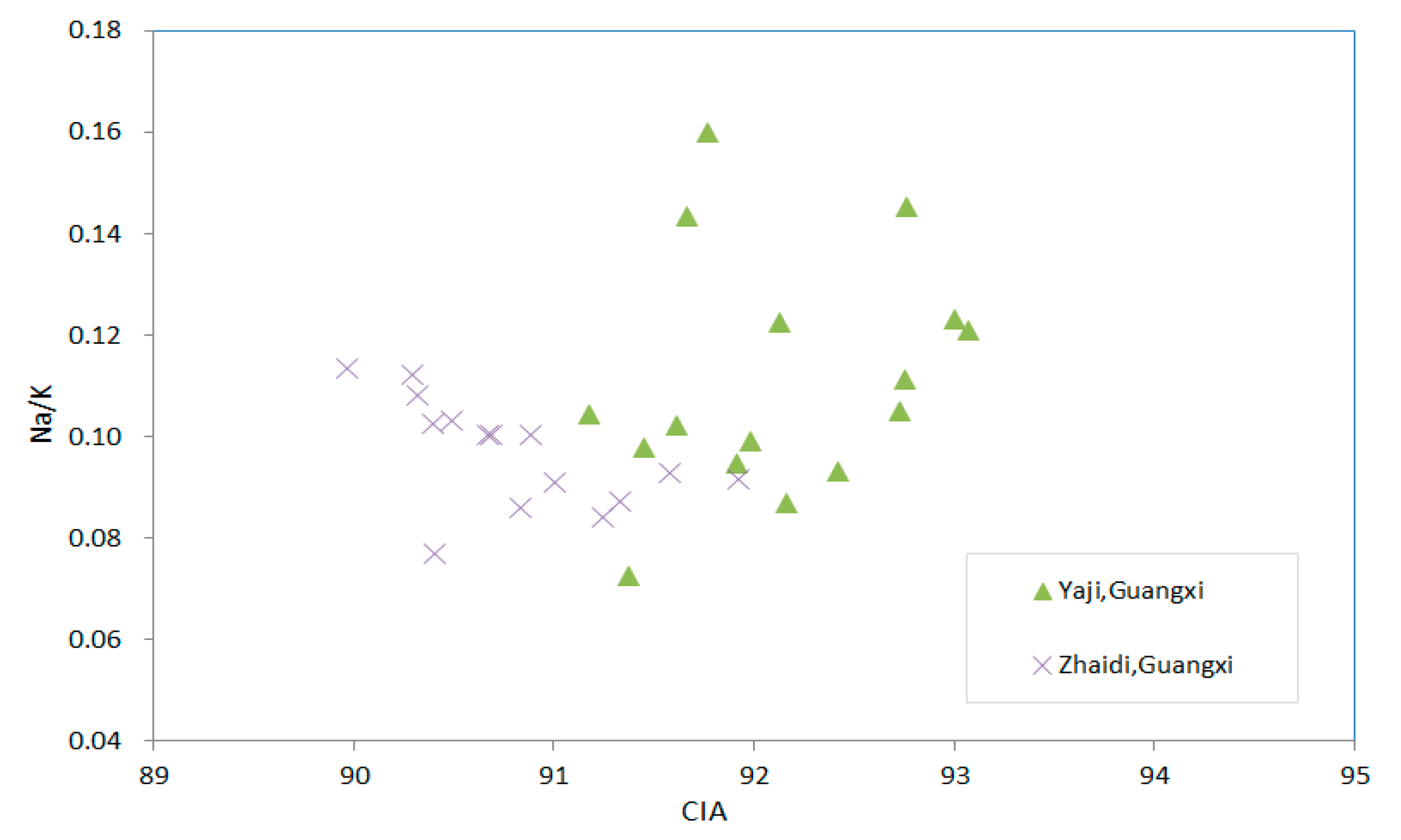
Excluding regional differences, we showed only Na/K ratio and CIA of Guilin weathering cover in the scatter plot (Figure 9), and found the CIA values were’t correlated with Na/K neither. By comparing the Na2O content of each profile, we found that the Na2O content in the weathering cover of carbonate rock were all low. Even on the rock–soil interface of the dolomite weathering profile and marl weathering cover, the Na2O contents are very low either. In all carbonate weathering cover, Na2O contents distributed uniformly and changed very little with the depth of the profile, which indicates the migration and leaching of Na2O are rapid. The Na2O migration may be affected by the rapid leaching of CaO during the weathering process. The low residue of Na2O in the weathering cover is the reason why the Na/K value did not correlate with CIA and cannot characterize weathering degree of carbonate weathering cover.
Due to the high content of K in carbonate weathering covers and significant changes in the profile, we used K/Al values to judge the difference of weathering between the carbonate weathering profiles. It can be seen from Figure 10 that K/Al values of most of points have a significant negative correlation with CIA (the fitting curve is y = 0.0002x2 − 0.0525x + 2.9183, R2 = 0.9741, n = 121) except for siliceous rock section and three points in southern Liaoning.
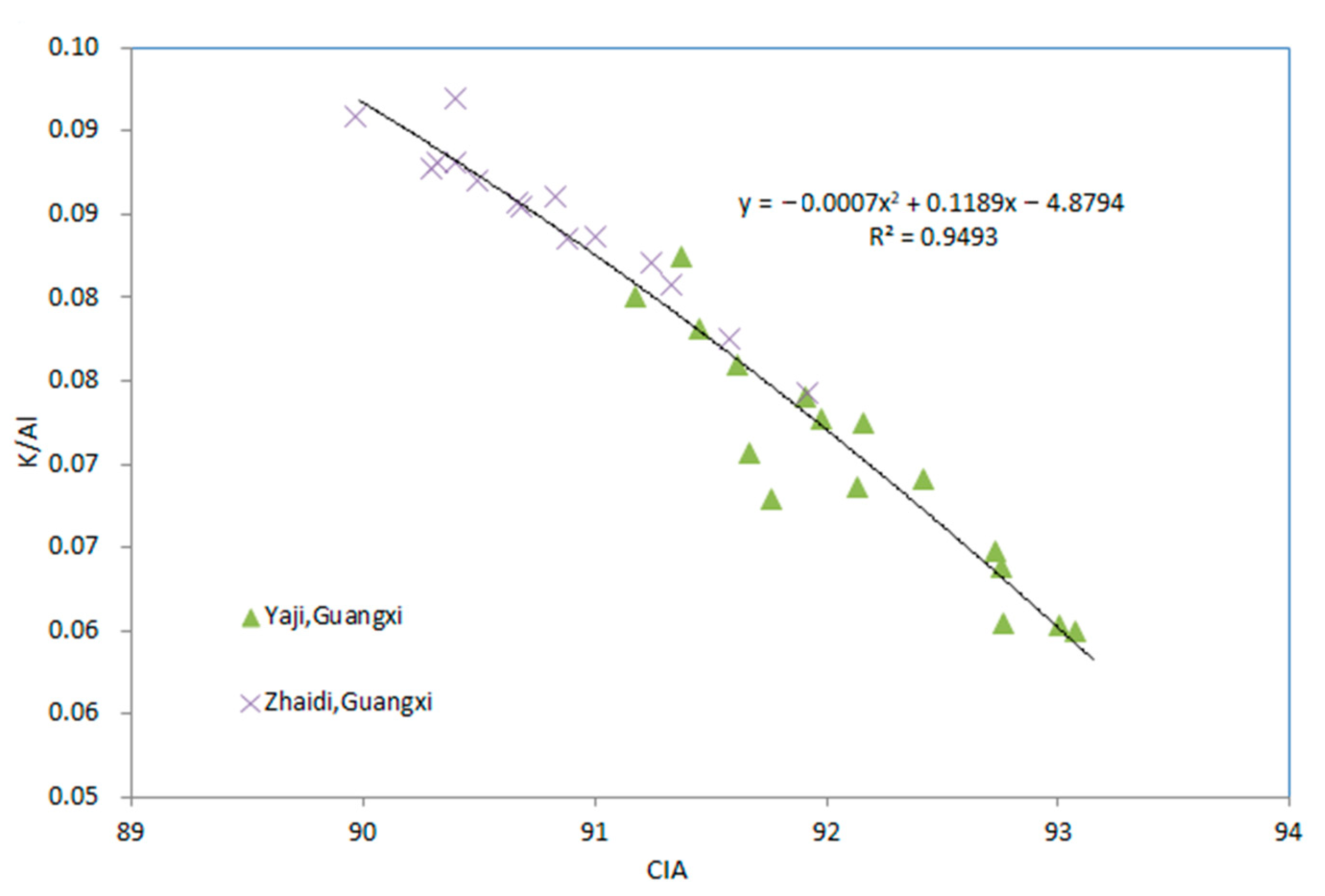
Similarly, the data of Guilin weathering cover were plotted separately either, and the K/Al value has a significant negative correlation with CIA (the fitting curve is y = −0.0007x2 + 0.1189x − 4.8794, R2 = 0.9493, n = 31, Figure 11). Which indicate that the differences in chemical weathering degree of carbonate profiles are mainly determined by the leaching loss of K2O and the increase of Al2O3. Thus, K/Al can be used to characterize the weathering degree of the carbonate profile. It can also be seen from Figure 10 that the data distribution of the dolomite weathering cover of Xinpu Guizhou, Jishou marl profile, and southern Liaoning carbonate profile with weak weathering intensity is relatively scattered, and the span range of K/Al and CIA of them is large. Two points of dolomite-weathering covers in Xinpu fall into the weakly weathered area; the data distribution of weathering cover of limestone in Guilin, Guangxi province and Xingyi, Guizhou province and weathering cover of dolomite in Anshun, Guizhou province are relatively concentrated with little difference. The reason may be that the profiles in Xinpu, Jishou are formed by in situ weathering residua with a thick weathering cover (5–7 m), and the weathering decreases and differs obviously with depth. However most of the weathering covers in other areas are thinner. The thickness usually does not exceed 3 m so that weathering can penetrate the entire profile. The weathering cover especially formed by pure limestone lacks a transition layer between rock and residua layer, and it was formed by the weathering of extremely thick limestone. These weathering covers undergo a certain distance of transportation, disturbance, and mixing during the soil forming process, resulting in a concentrated distribution of data points. For example, the points of Guilin weathering covers gather at the right end of the curve.

3.3.3. A-CN-K Diagram

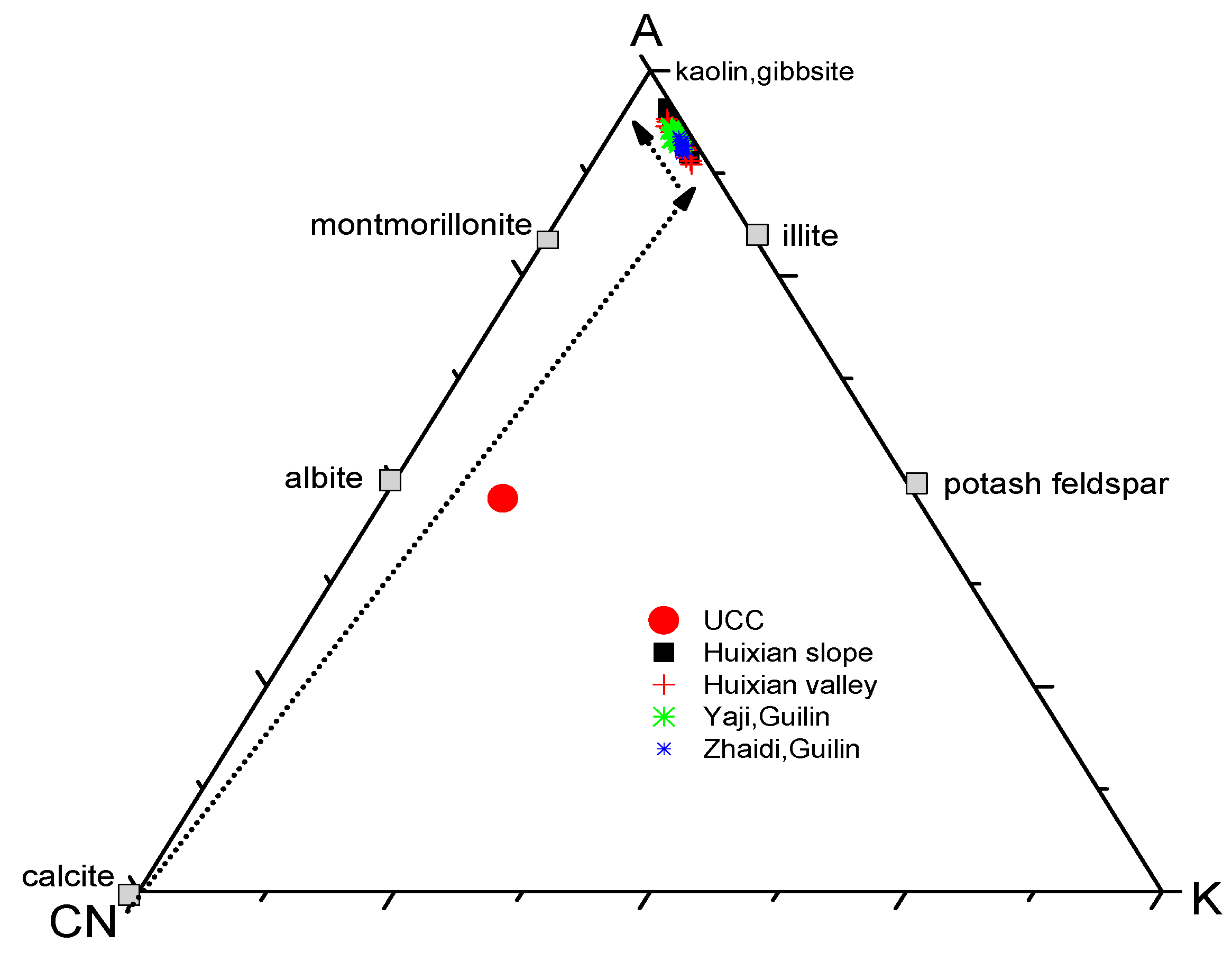
According to the principle of mass balance, and thermodynamic calculation of mineral stability, Nesbitt et al. proposed an A-CN-K (A represents mole of Al2O3; C represents mole of CaO*; N represents mole of Na2O; K represents mole of K2O) triangular model diagram to predict a continental chemical-weathering trend. This model can reflect the chemical weathering trend and the changes in main components and mineralogy in the process of chemical weathering. In the A-CN-K diagram (Figure 12 and Figure 13), the points of carbonate rock, powder layer, and Jishou marl are located at or near the end of CN. Except for the three points of southern Liaoning, most of points of the carbonate weathering cover are close to the A-K line and have a trend towards to the A-end when the profile locations from north to south. The purer the carbonate rock is, the closer its weathering cover is to the A-end. Na2O in carbonate weathering cover leaches rapidly. From carbonate rock to weathering cover, it is mainly manifested in the process of leaching loss of K2O and increasing Al2O3. In particular, the data points in Guilin of Guangxi, Xingyi of Guizhou, the upper part of Xinpu section, and Kunming, Yunnan are close to the A-K line and close to the A-end, indicating that the plagioclase in the sections is almost weathered, and the K removal and Al enrichment are very strong either.
Terrigenous shale is a weathering product of typical continental upper continental crust (UCC). The direction of UCC pointing to terrigenous shale represents a typical continental weathering trend. The points of a silicate profile in Bijie Guizhou are distributed on the trend line of UCC-terrigenous shale, and the distribution of points is basically parallel to the A-CN line, which shows that Al2O3 remains unchanged, K2O increases and Na2O decreases. The points of carbonate weathering cover are generally different from the weathering trend of typical continent, which is affected by the rapid leaching of CaO and MgO and the leaching loss of Na2O.

3.4. Factors Affecting Chemical Weathering

From the previous analysis, it is found that the chemical weathering of carbonate rocks is mainly affected by three factors: parent rock, terrain, and climate.
(1)
Parent rock
The composition of the parent rock has a fundamental influence on the speed and intensity of weathering process. It is negatively correlated with the content of insoluble matter in bedrock. The CIA (71.37) of marl weathering cover in Jishou, Hunan province is lower than that in Qinghai-Tibet Plateau and southern Liaoning, which is affected by the high content of argillaceous components in marl. With the increase of “insoluble matter”, the weathering trend will be close to the weathering trend line of silicate rock and continental crust. Figure 12 shows that the point distribution of argillaceous limestone in Jishou, Hunan province is farthest from the A-K line and is closer to the weathering trend line of siliceous rock than that of the pure carbonate weathering cover. The content of insoluble matter in silicate rock is very high, and the CIA of its weathering cover is significantly lower than that of carbonate rock. The average CIA of silicate weathering cover in Bijie, Guizhou is 69.66, which is far lower than that of dolomite weathering cover in Xinpu Zunyi, Guizhou (the average CIA is 78.02). Therefore, the difference in the composition of the parent rock leads to the obvious difference between carbonate rock and silicate rock in weathering intensity and the weathering process. The influence of lithology difference should be considered when using CIA of weathering cover for climate–environment inversion.
(2)
Terrain
The terrain mainly affects the intensity of weathering by redistributing water and heat conditions. Generally, the chemical weathering intensity decreases from the upper part to the lower part of the landform and from the surface layer to the deep layer of the profile because the hydrothermal conditions change in the upper part of a hill is greater than that in the lower part, and the chemical corrosivity of the fluid will gradually weaken in the lower part. For example, the CIA of karst weathering cover in upper slope in Yaji (92.05) is higher than that of the middle slope (91.89), and the CIA of Zhaidi upper slope weathering cover (91.21) is higher than that of the middle slope (90.51). However, the CIA of Yaji lower slope and Zhaidi depression is high due to the accumulation of more upper intense weathering materials, which conceals the fact that the weathering intensity is weakened at the low slope. The weakening trend of weathering intensity from shallow to deep of the profile is relatively common. The same trend was found in research of geochemistry of carbonate weathering cover in Guizhou province and in Qinghai-Tibet Plateau. The reason for this trend is that the weathering front continues to extend downwards with the parent rock being gradually decomposed into fine-grained material. At the same time, the weathered material above the weathering front continues to be transformed by the later weathering process, which makes the degree of weathering of the profile gradually weakens from shallow to deep [35].
(3)
Climate
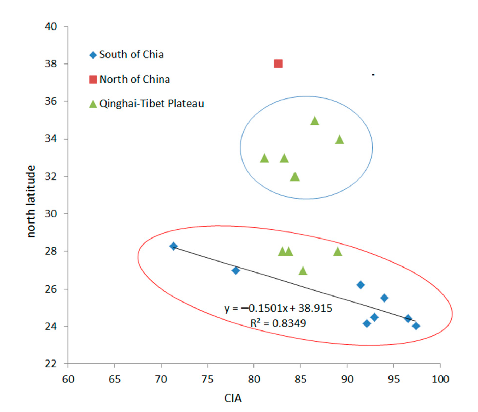
Climatic conditions are important factors that determine the speed, intensity and direction of carbonate rocks weathering. Temperature and precipitation, the two key climatic factors, play important roles in controlling chemical weathering. Temperature will enhance microbial activity, promote the decomposition of organic matter, and then affect the reaction rate of chemical weathering. Precipitation provides a medium for these reactions. At the same time, climatic conditions also control the number and types of plants. Under different climatic conditions, appropriate plant species and plant communities are developed, resulting in great differences in biochemical weathering intensity in different climatic zones. China is located in monsoon climate region, featuring simultaneous heat and precipitation. The temperature and rainfall are often inversely proportional to the latitude. According to the climatic division of China, the weathering cover of carbonate rock is divided into three groups: southern region, northern region and Qinghai-Tibet Plateau. The CIA and latitude of these covers were show in the CIA-latitude diagram (Figure 14, Table 4). The latitude of the points in southern China is negatively correlated with CIA. With the decrease in latitude, CIA increases significantly. The CIA values of points to the south of Pingba in Guizhou (latitude 26.22) are greater than 90, and the CIA reaches 97.36 in Dahua Guangxi (latitude 24.02). There is no correlation between latitude and CIA values at most points of the Qinghai-Tibet Plateau, which is due to the influence of complex tectonic movement. Southern China and the Qinghai-Tibet Plateau belong to different ancient landmasses, of which positions have changed differently since the beginning of Neogene. The weathering cover of carbonate rocks in the Qinghai-Tibet Plateau is an ancient weathering cover, and its latitude in formation period is quite different from modern latitude. The points in the southern region are basically located in the Yangtze ancient plate. Since the end of Oligocene, affected by the coastal Pacific tectonics, the Yangtze ancient land block has been mainly southeast–northwest horizontal compressed without large rotation. Therefore, the latitude difference in the plate is equivalent to that in Neogene, and the CIA of carbonate weathering covers in southern China has a negative correlation with the current latitude.

4. Conclusions

  • Karst weathering covers in Guilin have the similar geochemical characteristics with the weathering covers in other karst areas of China. First, their chemical composition is similar; second, their chemical composition is evenly distributed on the profile; third, compared with UCC, their Na, K, Ca and Mg show obvious loss, while the Fe, Al and trace\heavy metal elements show obvious enrichment. Trace elements are more enriched in Guilin weathering cover than red soil and loess. The rapid dissolution of Ca and Mg in the weathering process has an important impact on the migration and enrichment of elements.
  • The CIA of Guilin weathering cover and other carbonate weathering covers are much larger than that of the upper continental crust (UCC) (60.13), showing strong chemical weathering characteristics in humid and hot climate environments. The average chemical index of alteration (CIA) of Guilin karst weathering covers is 91.48, which is equivalent to that of carbonate weathering covers in Xingyi, Guizhou, and Kunming, Yunnan, and higher than that in central Yunnan, and Northern Guizhou, Qinghai-Tibet Plateau and Northern China.
  • Different from the weathering trend of silicate and loess, the soluble components (calcite and dolomite) of carbonate weathering covers in China rapidly and completely dissolved and leached in the early stage of weathering. These covers are in the stage of potassium leaching, iron and aluminum enrichment. Therefore, the CIA does not correlate with Na/K (molar ratio), but significantly negative correlate with K/Al (molar ratio).
  • The analysis of influencing factors of CIA of carbonate weathering cover shows that the CIA of carbonate weathering covers in southern China, including Guilin karst weathering cover, is negatively correlated with latitude. In terms of lithology, the chemical composition of the parent rock has an impact on the CIA of the karst weathering cover, and the content of "insoluble matter" in carbonate rock is negatively correlated with CIA of weathering cover. Topographically, the CIA of carbonate weathering cover tends to decrease from high to low and from shallow to deep.

Author Contributions

C.H. and F.L.: Conceptualization, Z.J. and Q.H.; methodology and investigation, H.W. and F.L.; software, H.L.; validation, C.H., T.L. and H.W.; writing—original draft preparation, H.W. All authors have read and agreed to the published version of the manuscript.

Funding

This research was funded by the National Natural Science Fund Project (41702281) and (U21A2016), Tibet Autonomous Region Science and Technology Planing Project (No.XZ202301YD0005C) and Key Projects of Guangxi Natural Science Foundation (No.2022GXNSFDA035067).

Data Availability Statement

Not applicable.

Acknowledgments

The authors are very grateful to the anonymous reviewers, and Li Yanqing, for their excellent comments and opinions on the revision and our research work.

Conflicts of Interest

The authors declare no conflict of interest.

References

  1. Taylor, L.L.; Banwart, S.A.; Valdes, P.J.; Leake, J.R.; Beerling, D.J. Evaluating the effects of terrestrial ecosystems, climate and carbon dioxide on weathering over geological time: A global-scale process-based approach. Philos. Trans. R. Soc. Lond. 2012, 367, 565–582. [Google Scholar] [CrossRef]
  2. Liu, C. Biogeochemical Processes and Surface Material Circulation: Erosion and Biogenic Factor Circulation in Southwest Karst Basin; Science Press: Beijing, China, 2007. [Google Scholar]
  3. Kump, L.R.; Brantley, S.L.; Arthur, M.A. Chemical Weathering, Atmospheric CO2, and Climate. Annu. Rev. Earth Planet. Sci. 2000, 28, 611–667. [Google Scholar] [CrossRef] [Green Version]
  4. Zhang, S.R.; Bai, X.Y.; Zhao, C.W.; Tan, Q.; Luo, G.J.; Wang, J.F.; Li, Q.; Wu, L.H.; Chen, F.; Li, C.J.; et al. Global CO2 Consumption by Silicate Rock Chemical Weathering: Its Past and Future. Earths Future 2021, 9, e2020EF001938. [Google Scholar] [CrossRef]
  5. Mehta, P.; Malviya, V.P. Weathering pattern of amphibolites in the different climate zones from Western Dharwar Craton, Southern India. Arab. J. Geosci. 2021, 14, 2435. [Google Scholar] [CrossRef]
  6. Sandeep, K.; Shankar, R.; Warrier, A.K. A Late Holocene Record of Variations in the Chemical Weathering Intensity and Pedogenesis in a Lake Catchment from Southern India. Aquat. Geochem. 2022, 28, 27–42. [Google Scholar] [CrossRef]
  7. Ji, H.B.; Wang, S.J.; Ouyang, Z.Y.; Zhang, S.; Sun, C.X.; Liu, X.M.; Zhou, D.Q. Geochemistry of red residua underlying dolomites in karst terrains of Yunnan-Guizhou Plateau: I. The formation of the Pingba profile. Chem. Geol. 2004, 203, 1–27. [Google Scholar] [CrossRef]
  8. Zhang, M.; Yao, Y.; Qiu, Z.; Mao, X.; Yang, L. Pedogenetic characteristics and taxonomic classification of soils developed from carbonate rocksin the south of China. J. Zhejiang Univ. Agric. Life Sci. 2019, 45, 54–65. (In Chinese) [Google Scholar]
  9. Zhou, D.; Wang, S.; Liu, X. Study on geochemical processes in limestone soil profiles. Geol. Geochem. 2005, 33, 31–38. (In Chinese) [Google Scholar]
  10. Liu, X.M.; Wang, S.J.; Feng, Z.G.; Sun, C.X. Identification of origin of limestone soil-case study of profiles in central and north Guizhou. Soil 2004, 36, 30–36. (In Chinese) [Google Scholar]
  11. Wang, S.J.; Liu, X.M.; Zhang, F. Fission track dating of secondary quartz in red weathering crusts of carbonate rocks in Guizhou Province. Geochimica 2005, 34, 33–40. (In Chinese) [Google Scholar]
  12. Wang, S.J.; Ji, H.B.; Ouyang, Z.Y.; Zhou, D.Q.; Zheng, L.P.; Li, T.Y. Preliminary Study on weathering and pedogenesis of carbonate rock. Sci. China Ser. D Earth Sci. 1999, 42, 14–23. [Google Scholar] [CrossRef]
  13. Feng, J.L.; Zhu, L.P.; Cui, Z.J. Quartz features constrain the origin of terra rossa over dolomite on the Yunnan-Guizhou Plateau, China. J. Asian Earth Sci. 2009, 36, 156–167. [Google Scholar] [CrossRef]
  14. Liu, W.J.; Liu, C.Q.; Zhao, Z.Q.; Xu, Z.F.; Liang, C.S.; Li, L.B.; Feng, J.Y. Elemental and strontium isotopic geochemistry of the soil profiles developed on limestone and sandstone in karstic terrain on Yunnan-Guizhou Plateau, China: Implications for chemical weathering and parent materials. J. Asian Earth Sci. 2013, 67–68, 138–152. [Google Scholar] [CrossRef]
  15. Wei, X.; Ji, H.B.; Li, D.J.; Zhang, F.L.; Wang, S.J. Material source analysis and element geochemical research about two types of representative bauxite deposits and terra Rossa in western Guangxi, southern China. J. Geochem. Explor. 2013, 133, 68–87. [Google Scholar] [CrossRef]
  16. Gong, Q.J.; Zhang, G.X.; Zhang, J.; Jiang, B.; Ma, N. Behavior of REE fractionation during weathering of dolomite regolith profile in southwest China. Acta Geol. Sin. 2010, 84, 1439–1447. [Google Scholar]
  17. Beckford, H.O.; Chu, H.S.; Song, C.S.; Chang, C.; Ji, H.B. Geochemical characteristics and behaviour of elements during weathering and pedogenesis over karst area in Yunnan–Guizhou Plateau, southwestern China. Environ. Earth Sci. 2021, 80, 59–79. [Google Scholar] [CrossRef]
  18. Feng, Z.G.; Liu, X.Z.; Han, S.L.; Ma, Q. Study on geochemical behavior of high field strength elements during weathering of carbonate rocks: Evidence from leaching experiment on carbonate rock. Carsologica Sin. 2018, 37, 315–329. (In Chinese) [Google Scholar]
  19. Jia, Z.Y.; Wang, J.X.; Zhou, X.D.; Zhou, Y.J.; Li, Y.; Li, B.J.; Zhou, S.L. Identification of the sources and influencing factors of potentially toxic elements accumulation in the soil from a typical karst region in Guangxi, Southwest China. Environ. Pollut. 2020, 256, 113505.1–113505.9. [Google Scholar] [CrossRef]
  20. Xia, J.C.; Wang, J.X.; Zhang, L.M.; Wang, X.; Yuan, W.; Zhang, H.; Peng, T.; Feng, X.B. Mass Balance of Nine Trace Elements in Two Karst Catchments in Southwest China. Sci. Total Environ. 2021, 786, 147504. [Google Scholar] [CrossRef]
  21. Zhu, G.X.; Xiao, H.Y.; Guo, Q.J.; Song, B.; Zheng, G.D.; Zhang, Z.Y. Heavy metal contents and enrichment characteristics of dominant plants in wasteland of the downstream of a lead-zinc mining area in Guangxi, Southwest China. Ecotoxicol. Environ. Saf. 2018, 151, 266–271. [Google Scholar] [CrossRef]
  22. Wen, Y.; Li, W.; Yang, Z.F.; Zhuo, X.X.; Guan, D.X.; Song, Y.X.; Guo, C.; Ji, J.F. Evaluation of various approaches to predict cadmium bioavailability to rice grown in soils with high geochemical background in the karst region, Southwestern China. Environ. Pollut. 2020, 258, 113645. [Google Scholar] [CrossRef] [PubMed]
  23. Dong, R.; Jia, Z.; Li, S. Risk assessment and sources identification of soil heavy metals in a typical county of Chongqing Municipality, Southwest China. Process Saf. Environ. Prot. 2018, 113, 275–281. [Google Scholar] [CrossRef]
  24. Ji, H.B.; Ouyang, Z.Y.; Wang, S.J.; Zhou, D.Q. Element geochemistry of weathering profile of dolomitite and its implications for the average chemical composition of the upper-continental crust. Sci. China Ser. D Earth Sci. 2000, 42, 23–35. [Google Scholar] [CrossRef]
  25. Gong, Q.J.; Deng, J.; Jia, Y.J.; Tong, Y.K.; Liu, N.Q. Empirical equations to describe trace element behaviors due to rock weathering in China. J. Geochem. Explor. 2015, 152, 110–117. [Google Scholar] [CrossRef]
  26. Jiang, Z.C. Element migration of karst dynamic system. Acta Geogr. Sin. 1999, 54, 438–444. (In Chinese) [Google Scholar]
  27. Riebe, C.S.; Kirchner, J.W.; Finkel, R.C. Long-term rates of chemical weathering and physical erosion from cosmogenic nuclides and geochemical mass balance. Geochim. Cosmochim. Acta 2003, 67, 4411–4427. [Google Scholar] [CrossRef]
  28. Zhang, X.B.; Bai, X.Y.; He, X.B. Soil creeping in the weathering crust of carbonate rocks and underground soil losses in the karst mountain areas of southwest China. Carbonates Evaporites 2011, 26, 149–153. [Google Scholar] [CrossRef]
  29. Huang, F.; Wei, X.; Zhu, T.; Luo, Z.; Cao, J. Insights into Distribution of Soil Available Heavy Metals in Karst Area and Its Influencing Factors in Guilin, Southwest China. Forests 2021, 12, 609. [Google Scholar] [CrossRef]
  30. Zhang, K.; Ji, H.B.; Chu, H.S.; Song, C.S.; Wu, Y.F. Material Sources and Element Migration Characteristics of Red Weathering Crusts in Southwestern Guizhou. Earth Environ. 2018, 46, 257–266. (In Chinese) [Google Scholar]
  31. Cui, Z.J.; Hong, Y.; Gao, Q.Z. The process and environment of polaeokarst in the northeast area of Qinghai-Xizang Plateau. Acta Geogr. Sin. 1996, 28, 408–417+481. (In Chinese) [Google Scholar]
  32. Wang, S.J.; Sun, C.X.; Feng, Z.G.; Liu, X.M. Mineralogical and geochemical characteristics of the limestone weathering profile in Jishou, western Hunan Province, China. Acta Mineral. Sin. 2002, 22, 19–29. (In Chinese) [Google Scholar]
  33. Ji, H.B.; Ouyang, Z.Y.; Wang, S.J.; Zhou, D.Q. Element geochemical characteristics of dolomitic weathering profile and its significance to the average chemical composition of upper continental crust: A case study of Xinpu profile in northern Guizhou. Sci. China Ser. D 1999, 29, 504–513. (In Chinese) [Google Scholar]
  34. Jiang, W.; Li, Y.H.; Wei, D.L.; Shen, J.J. Preliminary geochemical characteristics of red weatherng crust in Shicao profile, southern Liaoning province. J. Arid. Land Resour. Environ. 2019, 33, 126–131. (In Chinese) [Google Scholar]
  35. Gao, Q.Z.; Cui, Z.J.; Tao, Z.; Liu, G.N.; Hong, Y. The Nature, Formation Age and Genetic Environment of the Palaeokarst on the Qinghai-Xizang Plateau. Acta Geogr. Sin. 2002, 57, 267–274. (In Chinese) [Google Scholar]
  36. Taylor, S.R.; Mclennan, S.M. The continental crust: Its composition and evolution. J. Geol. 1985, 94, 57–72. [Google Scholar]
  37. Taylor, S.R.; Mclennan, S.M.; Mcculloch, M.T. Geochemistry of loess, continental crustal composition and crustral model ages. Geochim. Cosmochim. Acta 1983, 47, 1897–1905. [Google Scholar] [CrossRef]
  38. Cao, W.J.; Ji, H.B.; Zhu, X.F.; Zhou, X.Y.; Qiao, M.M. Contrast of geochemical features of the typical weathered profiles in Guizhou Plateau. Carsologica Sin. 2012, 31, 131–138. (In Chinese) [Google Scholar]
  39. Huang, Q.B.; Qin, X.Q.; Liu, P.Y.; Tang, P.P. Analysis on tablets dissolution rate and carbon sink under different vegetation in north China karst area: A case study of Fenyang, Shanxi Province. Carsologica Sin. 2013, 32, 258–265. (In Chinese) [Google Scholar]
  40. Wu, H.Y.; Qin, X.M.; Jiang, Z.C.; Luo, W.Q.; Deng, Y. Effect of Karstification on Concentration of Zn2+ in Lime Soil Water at Huixian Guilin. Res. Agric. Mod. 2009, 6, 761–765. (In Chinese) [Google Scholar]
  41. Wu, H.Y.; Huang, C.H.; Li, T.F.; Huang, Q.B.; Luo, F. Characteristics of element migration and influencing factors of lime soil in Guilin, Guangxi: A case study of lime soil in Huixian peak-cluster valley. Carsologica Sin. 2021, 40, 835–848. (In Chinese) [Google Scholar]
  42. Chen, Y.; Chen, J.; Liu, L. Chemical composition and characterization of chemical weathering of late tertiary red clay in Xifeng, Gansu Province. J. Geomech. 2001, 7, 73–81. (In Chinese) [Google Scholar]
  43. Chen, J.; An, Z.S.; Liu, L.W.; Ji, J.F.; Yang, J.D.; Chen, Y. Variations in chemical compositions of the eolian dust in Chinese Loess Plateau over the past 2.5 Ma and chemical weathering in the Asian inland. Sci. China Ser. D 2001, 44, 403–413. [Google Scholar] [CrossRef]
  44. Li, X.; Han, Z.; Yang, D. REE Geochemistry of xiashu loess in Zhenjiang, Jiangsu Province. Acta Pedol. Sin. 2006, 43, 1–7. (In Chinese) [Google Scholar]
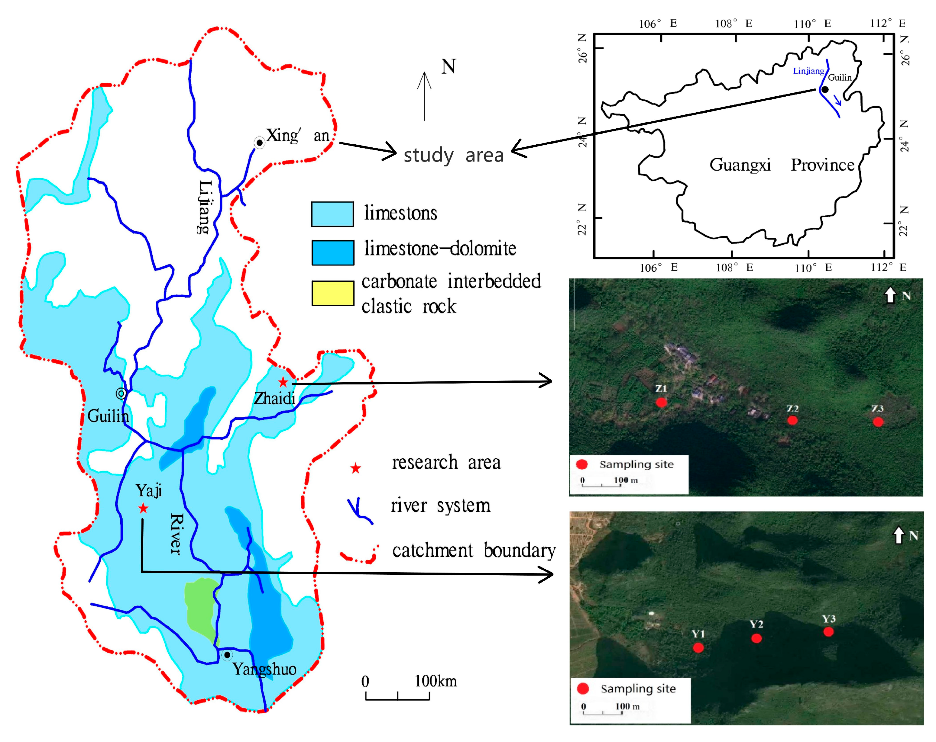
Figure 1. The location of the research sites and the distribution of sampling points.
Water 15 02944 g001
Figure 2. Geological section of study slope and in Yaji (a) and Zhaidi (b), Guilin city, Guangxi province.
Water 15 02944 g002aWater 15 02944 g002b
Scheme 1. Profile on karst weathering cover in Yaji experiment site.
Water 15 02944 sch001
Figure 3. Distribution of element variation coefficient of the residua profile in Yaji and Zhaidi site, Guilin.
Water 15 02944 g003
Figure 4. Normalization against average UCC for major elements in carbonate weathering covers in Guilin and other karst areas.
Water 15 02944 g004
Figure 5. Normalization curve against average of UCC for major and trace elements in Guilin karst weathering cover and the comparison with loess of Luochuan, the continental crust of China, red soil of Guangxi, and the red soil of Maocun.
Water 15 02944 g005
Figure 6. UCC standard curve distribution of common and trace elements in each section of Yaji.
Water 15 02944 g006
Figure 7. UCC standard curve distribution of common and trace elements in each section of Zhaidi.
Water 15 02944 g007
Figure 8. Scatter diagram of the relationship between CIA and Na/K of carbonate werthering covers in China (The point located in zone I indicates that it has not been weathered; The point located in zone II indicates weak weathering; The point located in zone III indicates moderate weathering; The point located in zone IV indicates strong weathering).
Water 15 02944 g008
Figure 9. Scatter diagram of chemical weathering parameters CIA and Na/K of Guilin weathering cover (All the points were located in strong weathering zone).
Water 15 02944 g009
Figure 10. Scatter diagram of the relationship between chemical weathering index CIA and K/Al of carbonate weathering cover (in the figure, the point located in zone I indicates that it has not been weathered; the point located in zone II indicates weak weathering; the point located in Zone III indicates moderate weathering; the point located in zone IV indicates strong weathering).
Water 15 02944 g010
Figure 11. Scatter diagram of the relationship between chemical weathering index CIA and K/Al of carbonate weathering cover in Guilin, Guangxi province.
Water 15 02944 g011
Figure 12. A-CN-K diagram of chemical weathering trend of carbonate weathering cover (arrow indicates chemical weathering trend, in the figure: A = Al2O3; CN = CaO* + Na2O; K = K2O).
Water 15 02944 g012
Figure 13. A-CN-K diagram of chemical weathering trend of weathering cover in Guilin, Guangxi (arrow indicates chemical weathering trend, in the figure:A = Al2O3; CN = CaO* + Na2O; K = K2O).
Water 15 02944 g013
Figure 14. Scatter diagram of relationship between chemical alteration index CIA and latitude of carbonate weathering covers in China.
Water 15 02944 g014
Table 1. Main chemical composition of Guilin Yaji and Zhaidi weathering cover and comparison with data from the reference literature.
Profile
(Depth cm)
pHSiO2Al2O3TFe2O3CaOMgOK2ONa2OTiO2P2O5MnOCIA
%%%%%%%%%%
Average value (Y3)6.3646.0524.1010.260.830.881.600.111.190.120.2992.05
Average value (Y2)6.6847.9923.049.910.921.181.570.101.200.120.2691.91
Average value (Y1)7.3245.9022.479.951.980.971.320.121.230.320.3492.45
Average value (Z3)6.9248.7521.779.061.112.001.650.091.420.110.2491.21
Average value (Z2)6.4347.5320.958.871.052.001.680.111.370.140.2990.51
Average value (Z1)6.9852.4520.708.670.881.561.630.111.650.160.2790.68
Weathering cover of Xingyi, Guizhou [30]45.1722.7210.391.541.271.270.111.1792.92
Qinghai-Tibet Plateau [31]48.4124.7110.480.131.803.480.220.840.210.0584.98
marlite of Jishou, Hunan [32]50.9021.827.520.471.397.040.340.720.120.0771.37
Guizhou dolomite [33]53.7118.626.110.213.894.440.130.470.080.0478.02
south Liaoning [34]54.8223.238.220.421.493.790.240.790.0182.61
Shangri-La, Yunnan [35]45.2426.2010.660.241.353.450.240.810.0785.25
Zhen’an, Shanxi [35]48.9824.2812.120.082.313.050.240.970.20.0886.31
Dao County, Hunan [35]44.132.4213.810.242.221.550.120.890.490.1493.98
UCC [36]66.0015.205.004.202.203.403.900.500.500.0647.92
Table 2. Main chemical composition of underlying bedrock of Yaji and Zhaidi weathering cover.
LithologySiO2Al2O3TFe2O3CaOMgOK2ONaO2CIA of
Weathering Cover
Yajilime stone0.5800.2900.17054.900.510.0890.02192.12
Zhaidilime stone0.160.0360.06055.080.580.00380.01490.80
Table 3. Main chemical composition and weathering indexes of profiles in Yaji and Zhaidi.
SiO2TFe2O3Al2O3CaOK2ONa2OCIANa/KK/Al
%%%%%%
Average value (Y3)46.0510.2624.100.831.600.1192.050.1010.072
Average value (Y2)47.999.9123.040.921.570.1091.890.0960.074
Average value (Y1)45.909.9522.471.981.320.1292.440.1390.064
Average value (Yaji)46.7310.0323.191.221.500.1192.120.110.07
Average value (Z3)48.759.0621.771.111.650.0991.210.0870.082
Average value (Z2)47.538.8720.951.051.680.1190.510.1030.087
Average value (Z1)52.458.6720.700.881.630.1190.700.1000.085
Average value (Zhaidi)49.588.8721.141.011.650.1190.800.100.08
Table 4. Regional latitude and climate characteristics of carbonate weathering covers in China.
RegionLocationg of Weathering CurstAnnual Average Temperature/°CAnnual Average Rainfall/mmLatitudeCIAModern Climate
SouthJishou, Hunan17.00139828.2971.36Subtropical humid monsoon climate
Xinpu, Zhunyi15.3110742778Subtropical humid monsoon climate
Pingba, Guizhou14.30135026.2291.45Subtropical humid monsoon climate
Daoxian, Hunan23.00151825.5293.98Subtropical humid monsoon climate
Kunming, Yunnan14.91101224.4396.54Subtropical humid monsoon climate
Xingyi, Guizhou16.30147224.4992.91Subtropical humid monsoon climate
Guilin, Guangxi19.00195024.1892.14Subtropical humid monsoon climate
Dahua, Guangxi20.00146024.0497.36Subtropical humid monsoon climate
QingHai TibetAnduo, Tibet−2.78435.73284.28Semi humid monsoon climate in plateau sub cold zone
Dingri, Tibet−7.403192883–89Semi humid monsoon climate in plateau sub cold zon
Yushu, Qinghai3.004863381.12Plateau alpine climate
Langmusi, Ganshu1.207823489.19Plateau alpine climate
Zhongdian, Yunan5.85646.92785.25Plateau alpine climate
Wudu, Ganshu15.004703383.22Subtropical semi humid climate
Zhenan, Shanxi12.2080433.4286.31Subtropical semi humid climate
NorthDalian, Liaoning10.89601.93882.61Warm temperate sub humid monsoon climate
Disclaimer/Publisher’s Note: The statements, opinions and data contained in all publications are solely those of the individual author(s) and contributor(s) and not of MDPI and/or the editor(s). MDPI and/or the editor(s) disclaim responsibility for any injury to people or property resulting from any ideas, methods, instructions or products referred to in the content.