Article

Composite Factors during Snowmelt Erosion of Farmland in Black Soil Region of Northeast China: Temperature, Snowmelt Runoff, Thaw Depths and Contour Ridge Culture

College of Water Conservancy, Shenyang Agricultural University, Shenyang 110866, China
*
Author to whom correspondence should be addressed.
Water 2023, 15(16), 2918; https://doi.org/10.3390/w15162918
Submission received: 17 June 2023 / Revised: 10 August 2023 / Accepted: 10 August 2023 / Published: 12 August 2023
(This article belongs to the Special Issue Effects of Hydrology on Soil Erosion and Soil Conservation)

Abstract

:
Snowmelt erosion could cause serious damage to soil quality and agricultural production conditions of slope farmland in the black soil region of northeast China. Contour ridge tillage is a traditional and effective measure to mitigate soil loss on slope farmland. However, the characteristics and influence factors of snowmelt erosion of slope farmland with contour ridge culture and the effect of this measure on the snowmelt process have not been comprehensively investigated, especially at the field scale. To bridge the gap, in situ observation was conducted on the snowmelt erosion process of a typical farmland in Baiquan County, Heilongjiang Province, China. The results revealed that during the snowmelt erosion period, the average daily snowmelt runoff volume and sediment concentration exhibited a trend of first increase and then a subsequent decrease. In the early stage, although the sediment concentration was large, limited discharge and soil thaw depths led to minimal soil loss. In the following stage, due to increased runoff and thaw depths, 94% of the total soil loss amount was obtained with an obvious erosion path formed. For each event, when soil thaw depths were shallow, sediment concentration had a high and early peak, whereas a reverse trend was observed when thaw depths increased. The hysteresis relationship of discharge–sediment indicated that the location where snowmelt erosion primarily occurred would change, under the influence of variations in runoff, freeze and thaw action, thaw depths, and micro-topography. The results could provide a guide in the control of soil erosion in seasonal snowmelt-erosion-prone areas.

1. Introduction

Snowmelt erosion occurs in areas with high latitudes and high altitudes [1,2,3,4]. In these ecologically vulnerable regions, snowmelt erosion could make severe damage to land health, water quality, crop yield, and ecological balance [5,6,7,8]. Compared with rainfall-induced soil erosion, snowmelt-induced erosion has its own distinct characteristics, such as snowmelt runoff, which is sensitive to variations in radiation and air temperature, surface soil being affected by freeze and thaw action, the frozen soil layer reducing infiltration, and low vegetation coverage during the snowmelt period [9,10,11].
In Nordic countries, snowmelt erosion is particularly severe combined with rainfall for partially thawed soil as infiltration is restricted, leading water pollutants to recipient water bodies [12]. In the Tibetan Plateau region, spring melt water erosion is affected by multiple factors on an alpine meadow slope, and fast melting at high flow rates could promote soil erosion [13,14]. Spatially distributed soil erosion should focus on water infiltration, the influence of ice and snow on runoff, and variations in soil surface structure caused by freeze and thaw action [15]. Snowmelt erosion could result in micro-topography changes in space and over time due to frost heave, snowpack, erosion, and deposition by overland flow [16].
Northeast China is the region with the largest seasonal snow amount in the country. Snow accumulation is a prerequisite for snowmelt erosion. The spring thawing period is a time when soil freeze–thaw processes occur strongly, which is generally prone to soil erosion. The theoretical research on soil erosion processes under the influences of snowmelt runoff and freeze and thaw action in China still requires extensive field observations and data. The related research mainly focuses on glaciers and frozen soils, with an emphasis on hydrological processes.
Snowmelt erosion in northeast China accounts for a non-negligible proportion of total soil erosion throughout the year [17]. To some extent, the harm of snowmelt erosion is severely underestimated. Recent research on soil erosion in northeast China has mainly focused on observing rainfall-induced soil erosion and simulation experiments under artificial conditions. In experimental designs, an external water supply method is usually used to simulate snowmelt runoff. However, under natural conditions, there is still snow cover during snowmelt periods, which would gradually disappear. Incompletely melted snow may preserve snowmelt runoff to some extent. At the same time, local micro-topography reconstructed by soil and water conservation measures could also block water from snowmelt and soil-thawing processes and increase infiltration. Consequently, the release of snowmelt water could be influenced by various factors. Thaw depths of surface soil change across different points on slope because many factors could change soil freeze and thaw process, such as air temperature, snow ablation, snowmelt discharge, and local terrain [18,19].
The black soil region in northeast China is an important commodity grain base in the country. During the spring thaw period, the combined effects of freeze–thawing action, snowmelt discharge, and low vegetation cover could lead to serious snowmelt erosion, which might be more severe than rainfall-induced soil erosion in some locations. Snowmelt erosion has a significant impact on agricultural production and regional economic safety [20]. Snowmelt erosion on a slope has a sediment transport and deposition process, which could be revealed by the sediment–discharge hysteresis relationship by quantifying time-scale dynamics [21]. Moreover, potential sediment sources could also be confirmed. Tillage methods could reduce soil erosion [22,23,24]. Contour ridge tillage is a traditional measure for soil erosion control in this area with small gradients but long slope lengths [25]. Historically, there has been an underestimation of the detrimental impact of snowmelt erosion. While gully erosion resulting from snowmelt erosion lies beyond the scope of this observation, it is crucial to acknowledge that the morphological alterations caused by snowmelt erosion may exacerbate subsequent soil erosion processes.
However, there has been limited research focused on the snowmelt erosion process of slope farmland with contour ridge culture at the field scale. To address this gap, we conducted an observation on typical slope farmland with this measure. The primary objectives of this study were (a) to monitor the snowmelt erosion process, including snowmelt discharge and soil loss amounts and identify critical influencing factors and (b) to analyze the effects of influencing factors such as air temperature changes, thaw depths of surface soil, and micro-topography reshaped by contour ridge culture on the snowmelt erosion process. The findings of this study will provide a scientific and theoretical foundation for addressing snowmelt erosion and designing effective soil conservation measures in areas with seasonal snow cover prone to snowmelt erosion.

2. Materials and Methods

2.1. Study Site

The study site is situated in the Jiusheng small watershed (47°26′54″ N, 126°18′8″ E), Baiquan County, Heilongjiang Province, China. The region is characterized as a combination of over-flood plain and hill areas, with a large proportion of low mountains and hills. The climate belongs to the mid-temperate continental monsoon climate zone, with a feature of cold and dry winters and hot and rainy summers. The annual average rainfall is 490 mm, with 70% of the total amount concentrated between July and September. The annual average temperature is 1.5 °C. The spring snowmelt period is generally from middle to late March, when air temperatures rise rapidly during the daytime. Temperatures rise above 0 °C in the daytime and drop below 0 °C at night, leading to freeze and thaw action, which makes the soil susceptible to snowmelt erosion. The main land use patterns in the region consist of cultivated land and forest land. The major cultivation form on slope farmland is contour ridge tillage or horizontal ridge farming. The main forms of soil erosion are surface erosion and gully erosion occurring on slope farmland.
The investigation site represents a typical slope farmland catchment that has been cultivated over 50 years in a small watershed. It spans approximately 330 m from east to west and 105 m from north to south, with the middle position lower than other parts. The land use type is contour ridge culture. The cultivation measures are corn ridges, planted in May and castrated in October, with minimal crop residue remaining on the ground. The average slope of the site is 2.47. However, the complete slope exhibits non-uniform characteristics, displaying a concave profile overall, with notably steep inclines in both the uphill and downhill regions. The central section of the slope features gentle terrain, giving rise to localized depressions. Moreover, the micro-topography of the entire slope demonstrates pronounced spatial heterogeneity, attributed in part to continuous cultivation practices. Snowmelt erosion is severer because the slope exhibits considerable length, coupled with an extensive catchment area, leading to a substantial accumulation of runoff on the slope with enough snow cover (Figure 1).

2.2. Snowmelt Erosion Process Observation

2.2.1. Snowmelt Runoff and Soil Loss

The observation was carried out from middle to late March 2018. There were mainly sunny days. The temperature gradually increased in the daytime, with a minimum of above 0 °C and a maximum of nearly 20 °C. Snow began to smelt, and then erosion occurred as a result of snowmelt runoff and freeze–thaw action. Samples were collected from 23 to 26 March, with a simple device and collecting buckets at the designated outlet, located at the head of a gully as shown in Figure 1.
The sample interval was 30 min. Sampling times and runoff amounts were recorded on-site. The collected runoff in buckets was evenly stirred, 500 mL of which was transferred into sampling bottles. Then, samples were brought to the experiment room and settled for more than 24 h and measured by using a drying method in order to obtain the sediment concentration. The samples were placed in a constant temperature drying oven at 105 °C for 8 h to make the water evaporate completely. Then, the remaining dry sediment was obtained, and sediment concentrations were accordingly calculated.

2.2.2. Factors and Measurements

The temperature and thaw depths of the surface soil were simultaneously measured or recorded simultaneously during the snowmelt period in order to analyze their influence on snowmelt erosion. Temperatures were recorded hourly using a thermometer in situ. Steel pines were used to measure thaw depths of surface soil at two locations, namely the top of the slope and a nearby place close to the outlet, at 11:00 and 15:00, separately. Steel pines were inserted into the soil until blocked by a frozen layer, and the lengths of penetration into the soil were recorded as thaw depths with a ruler. Meanwhile, the rills and micro-topography affected by contour ridge culture across the slope were also investigated through photography.
In this region, seasonal snowmelt erosion predominantly transpires within a condensed timeframe of approximately one week. Despite its significance, comprehensive observations on the fundamental aspects of snowmelt erosion worldwide remain relatively in need. Given these circumstances, the observation was planned meticulously, striving to capture intricate details and augment the sampling frequency in order to provide sufficient evidence to elucidate the distinctive characteristics of snowmelt erosion in this specific region.

2.3. Data Analysis

The snowmelt erosion process was represented by several following points: daily changes in snowmelt runoff and sediment, variations in runoff and sediment under the influence of air temperature changes at each event, and the discharge–sediment hysteresis relationship using the method proposed by Williams [26] to reveal the dynamic feature of sediment and discharge and potential sediment sources through differences between the two parameters. Subsequently, the roles of the following composite factors in the snowmelt erosion process were examined, including air temperature, discharge, freeze–thaw action or thaw depths of the surface soil, and topographic features. Snowmelt erosion has obvious spatial heterogeneity, so erosional appearance, sediment sources, and the status of the contour ridge system were also taken into consideration.

3. Results and Discussion

3.1. Daily Average Snowmelt Runoff and Soil Loss

Snowmelt erosion in this investigation took place intensively from 23 to 26 March 2018. The daily average snowmelt erosion process is illustrated in Figure 2, presenting the average snowmelt runoff and sediment concentration.
  • On 23 March only 0.36% of the total snowmelt runoff amount was observed, and the low proportion was due to melted water being partially retained in the snow cover and frozen surface soil.
  • On 24 March, as the air temperature continued to rise, the average snowmelt runoff exceeded that of the previous day, accounting for 4.58% of the total soil loss amount (sediment concentration multiplied by total runoff). The result could be attributed to a reduction in the water storage capacity of snow and soil. So, more melt water was released in the form of snowmelt discharge.
  • On 25 March, because the air temperature increased rapidly, the snowmelt process was accelerated synchronously. Consequently, 94.49% of the total runoff amount was obtained, including both melted snow and water from thawed soil.
  • On 26 March, there was no obvious snow cover. However, 0.57% of total runoff was still collected, which was mainly from the accumulation and thawing of liquid water in the surface soil.
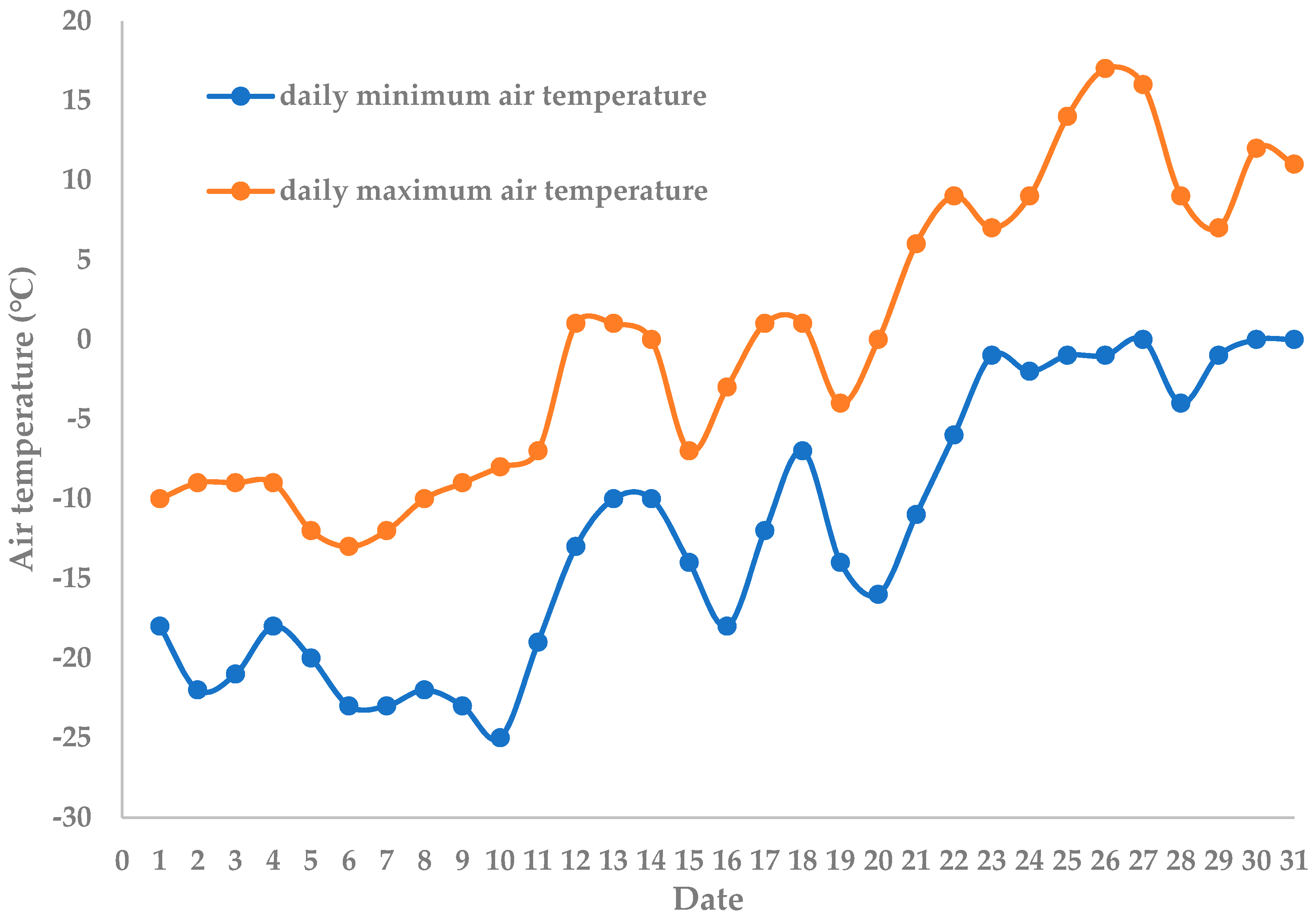
Throughout the 4 days, the air temperature remained below 0 °C at night but rose above 0 °C during the daytime (even the lowest temperature). Thus, the primary driving factor for snowmelt was the air temperature, which was consistent with temperature-driven snowmelt in an Alpine catchment [27].
  • On 23 March, as the air temperature increased slowly, snow ablation was relatively obvious on the upper slope, resulting in some parts of bare soil. However, most of the site was covered by snow, with frozen surface soil. Meanwhile, snowmelt did not make a large runoff as discussed above. As a result, there was very little soil loss, accounting for only 0.2% of the total amount.
  • On 24 March, much more water was released from the melting snow cover and thawed soil, which enabled the snowmelt runoff to reach the outlet, by infiltration, passing along the ridge or flowing through the furrow. Simultaneously, substantial portions of the topsoil began to thaw, making sediment particles much more susceptible to being eroded, especially in several places with broken ridge furrows. Sediment concentration increased rapidly, reaching a maximum of 17.32 kg/m3 at 11:00, and accounted for 7.5% of the total soil loss amount.
  • On 25 March, the rates of snowmelt and soil thawing further intensified, leading to the majority of the runoff and soil loss (92.3% of the total amount). Micro-topography also played a significant role in promoting snowmelt erosion [16]. Water stored in ridges and furrows would infiltrate, or run along/through them, leading to much more soil failure in forms of scouring or collapse. Local and whole distinct flow routes in situ were evident, and the centralized snowmelt discharge produced severe erosion.
  • No soil loss had been observed on the 26 March.
Snow accumulation and snowmelt are critical factors in snowmelt hydrology and erosion [4]. Notably, melted water could be held by snow cover, the contour ridge system, or small dams created by straw and ice [15]. Additionally, soil particles undergoing freeze and thaw action are more susceptible to erosion [28], although during early period soil erosion, they are restricted by unthawed surface soil. These complex and composite components are crucial for analyzing the snowmelt erosion process.

3.2. Air Temperature

Figure 3 shows the air temperature variation throughout March. Snowmelt discharge was collected on 23 March, when the minimum air temperature increased and rapidly approached 0 °C. The subsequent 4 days had similar minimum air temperatures, but the maximum temperature increased rapidly. The occurrence of snowmelt erosion requires both sufficient snow accumulation and a rapid rise in air temperature.
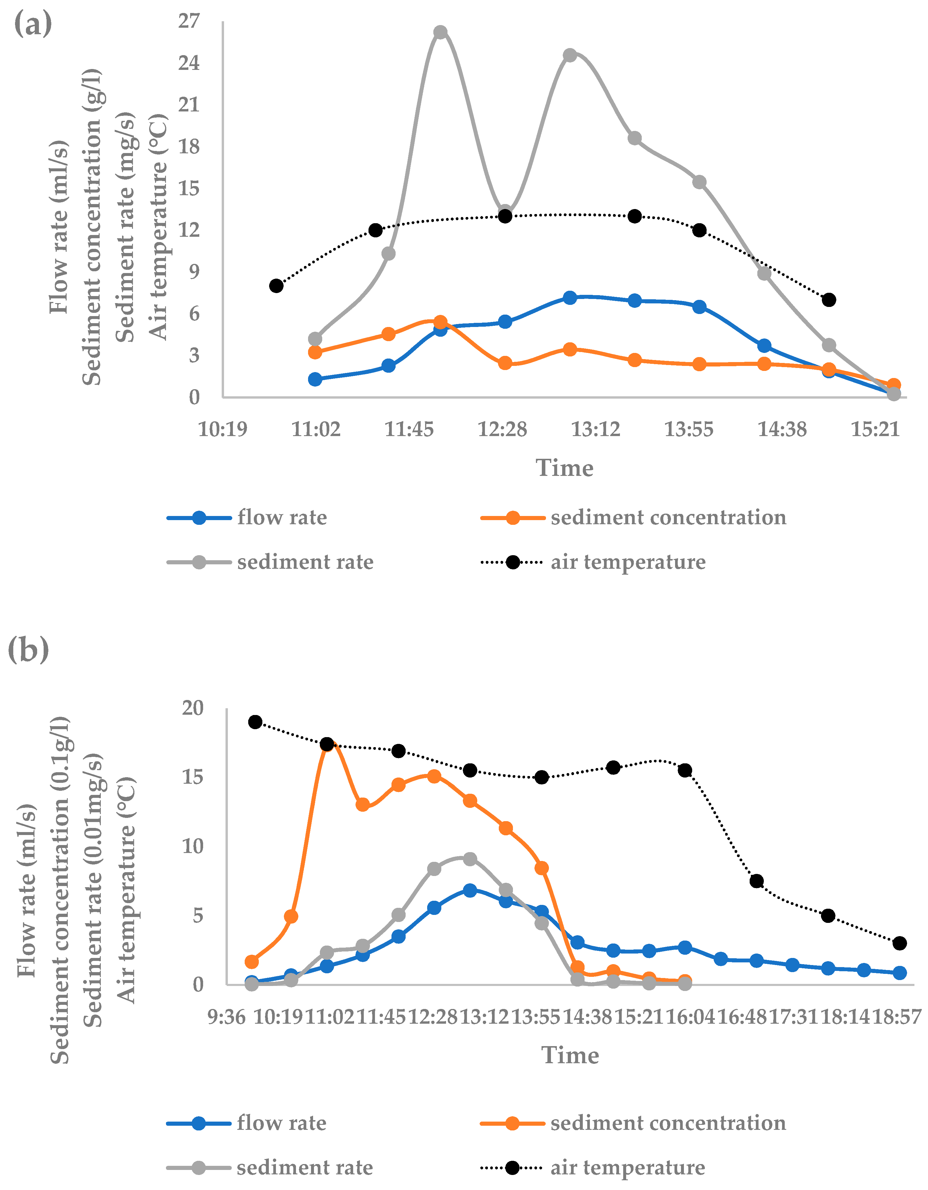
Variations in air temperatures, snowmelt runoff, and the sediment concentration of each event are presented in Figure 4.
  • On 23 March, snowmelt runoff began around 11:00, reaching its peak at 13:00, with a duration of 3.5 h. The air temperature ranged between 12 and 13 °C from 11:30 to 14:00. The sediment concentration showed a similar trend, reaching its maximum value at 12:00, 1 h earlier than the peak discharge. Despite a relatively high sediment concentration occurring momentarily, the first day of snowmelt erosion had limited snowmelt runoff and soil loss.
  • On the morning of the 24 March, the sediment concentration gradually increased with the rise in snowmelt runoff, peaking at 13.72 kg/m3 at 11:00, which was later than the peak of snowmelt runoff by 30 min. In the afternoon, as the weather changed from cloudy to sunny, and under the influence of rising temperatures and favorable radiation, the declining runoff showed a small rebound. However, due to insufficient surface soil thawing, particularly in snow-covered regions, the sediment yield rapidly decreased after 14:00. The duration of the snowmelt event was approximately 9 h, during which melted water stored in the snow and frozen surface soil was released to a significant extent, causing the breakage of some ridge furrows and the formation of an obvious water flow path near the outlet with a notable width and depth. While snowmelt water could be retained in the snow and furrows or infiltrate into thawed soil, limiting the runoff amount, the shallow soil thaw depths prevented the easy erosion of soil particles by the snowmelt discharge. Consequently, the sediment concentration was primarily influenced by the thawed surface soil particles in the early stage, while snowmelt erosion became the limiting factor in the later stage due to the slow rate of soil thawing.
  • On 25 March, the temperature and radiation improved compared to earlier days, but the weather became cloudy and the temperature slightly declined. The maximum runoff was observed at 13:30, with two peaks observed for both runoff and sediment concentration. The first peak occurred synchronously for both parameters, while the second peak exhibited a 0.5 h delay in sediment concentration compared to the runoff. Based on these observations, it can be inferred that snowmelt runoff is influenced by multiple factors, including snowmelt rate, water from thawed soil, and their relative positions. At the end of the day, most of the snow had melted, and the previously existing melted water in furrows was released, contributing to the complexity of runoff sources and potentially leading to the occurrence of multiple peaks.
  • On 26 March, due to a lack of runoff source, only a slight amount of discharge was collected for less than 3 h, and no sediment yield was investigated. The main runoff sources included water from thawing surface soil and a small amount of snow and ice near the outlet.

3.3. Thaw Depths of Surface Soil

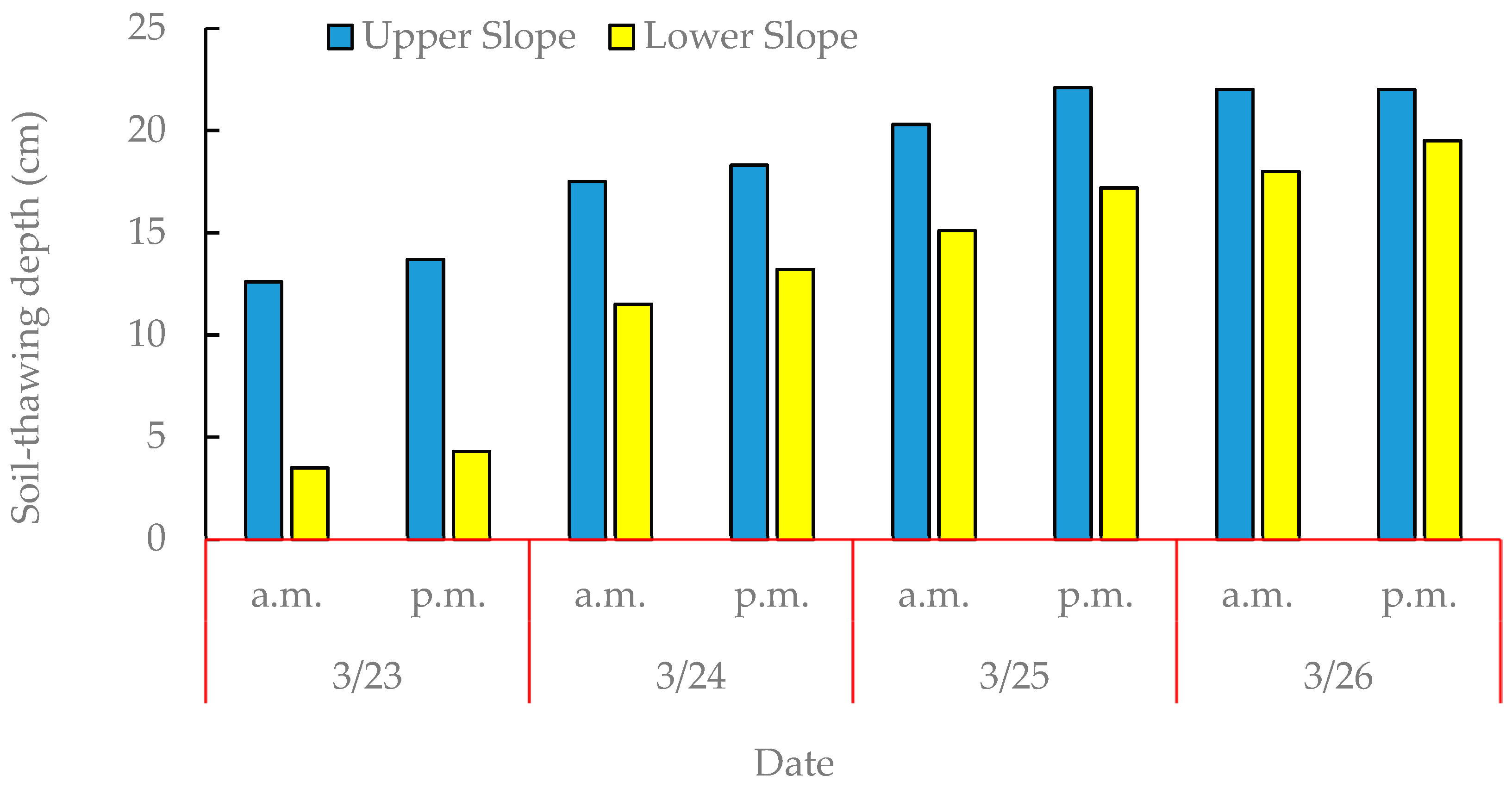
Thaw depths of surface soil at the upper slope and lower slope are indicated in Figure 5. Overall, the soil-thawing depths increased each day on the whole.
  • On 24 March, because the snowmelt soil-thawing depths were shallow, even though there was sufficient snowmelt runoff, soil loss was still limited [29]. Runoff lasted from 11:00 to 19:00, while sediment yield lasted until 15:00 with an early peak occurring 1.5 h earlier compared with the runoff.
  • On 25 March, there were deep soil-thawing depths throughout the entire day, coupled with an initial snowmelt runoff with a substantial early influx. Although the sediment concentration was marginally lower than the preceding day, the dominant sediment yield resulted from the significant proportion of the total runoff volume.
Freeze–thaw action is a remarkable characteristic of snowmelt erosion compared to rainfall-driven erosion, and the soil-thawing depth is a crucial driving factor for soil structure and the snowmelt erosion process [10,12]. The soil-thawing depth is related to sediment concentration, and the total sediment yield results from both sediment concentration and runoff volume [30]. At the beginning of the snowmelt erosion period, most of the site was covered with snow cover. Snowmelt and soil thawing predominantly occurred on the upper slope. The snowmelt gradually moved to a lower position, causing much more bare soil. While snowmelt occurred mainly in the upper region, a significant amount of melt water was retained by the snow cover. Therefore, the soil-thawing depths of the upper slope were deeper than those of the lower slope. The limited soil loss monitored can be attributed to the shallow thawed soil and a large proportion of the surface covered by snow.
In the upper and middle parts of the slope, a considerable number of furrow platforms were broken through by snowmelt runoff, leading to an obvious flow path towards the outlet. The increasing soil-thawing depth and the generation of the flow route promoted sediment yield. A large volume of snowmelt runoff carried more eroded sediment particles during the middle to late stages of the process, which is different from the previous day when the limited sediment was obvious due to the shallow soil-thawing depth. Additionally, melt water could not infiltrate into the incomplete thawing layer, making the thawed sediment particles much more susceptible to being eroded [12]. Compared with the results of other days, it is evident that soil loss increased with the deepening of the soil-thawing depth. Snowmelt erosion was sensitive to variation in soil-thawing depth. A larger depth resulted in earlier and larger initial runoff periods. Therefore, it could be concluded that snowmelt erosion is significantly affected by both snowmelt runoff and soil-thawing depth [10].

3.4. Sediment–Discharge Hysteresis Relationship

Snowmelt runoff and sediment concentration exhibited distinct variations at each event. The complexity of driving factors and material sources lead to the non-synchronous process of runoff and sediment. In order to reveal this phenomenon, the sediment–discharge hysteresis relationship method [26] was used to analyze the daily variation in snowmelt runoff and sediment, excluding 26 March, as shown in Figure 6. There was a clockwise hysteresis relationship between runoff and sediment for the 2 previous days, which is consistent with observations of snowmelt erosion of an agricultural watershed in Finland [31]. However, for 25 March, a compound style was obtained, with an initial short counter-clockwise loop followed by a clockwise loop, and another counter-clockwise loop again. Clockwise hysteresis exists when the sediment concentration peaks arrive earlier than the runoff [26]. If sediment sources were relatively limited in a basin, and taken away quickly by discharge, the reduction in sediment concentration would be more rapid than the runoff, leading to a clockwise hysteresis [32,33].
  • On 23 March, snowmelt runoff was small, and topsoil had just begun to thaw, so runoff with weak scouring ability had only one peak. Consequently, only sediment near the collecting outlet could be eroded, forming a clockwise hysteresis.
  • On 24 March, as the topsoil further thawed, a certain amount of sediment moved towards the lower slope but could not reach the outlet. This produced a high sediment concentration in the early stage under the influence of snowmelt runoff. However, a clockwise hysteresis showed that in the late stage, sediment turned limited again, because incompletely thawed soil was not easily scoured or flushed. The sediment sources on this day included thawed soil particles near the outlet, as well as sediment accumulated and transported along the slope, particularly from the existing flow route.
  • The runoff–sediment relationship on 25 March was relatively complex and exhibited a compound hysteresis containing several parts, i.e., a clockwise hysteresis for the second part and a counter-clockwise for the other two parts. The counter-clockwise hysteresis reflects that the sediment source is farther away from the outlet [33], so the sediment path has a longer distance than that of the flow path. The slope had a length of about 330 m, and an obvious flow route originated from the middle position. Therefore, the long distance caused the repeated process of erosion and sedimentation. Additionally, the melted water also changed at different times and positions. The sediment source was abundant at the first and last stages but became limited after being flushed within the middle stage. These variations led to a changeable hysteresis pattern. Compared to the previous days, on this day, thaw depths of the lower slope were larger than ever, so soil erodibility became larger gradually, and, eventually, the main sediment source became close to the outlet again. Thus, the runoff–sediment hysteresis relationship was significantly influenced by sediment sources affected by incompletely thawed soil and flow route patterns.

3.5. Contour Ridge Culture and Micro-Topography

According to the aforementioned observation, snowmelt erosion had various erosion patterns at different sites along the slope. Generally, the upper slope had a main form of surface erosion including rill erosion, while the lower slope erosion experienced a collapse of ridge platforms and the overlying ridge by snowmelt, especially along the prominent flow route.
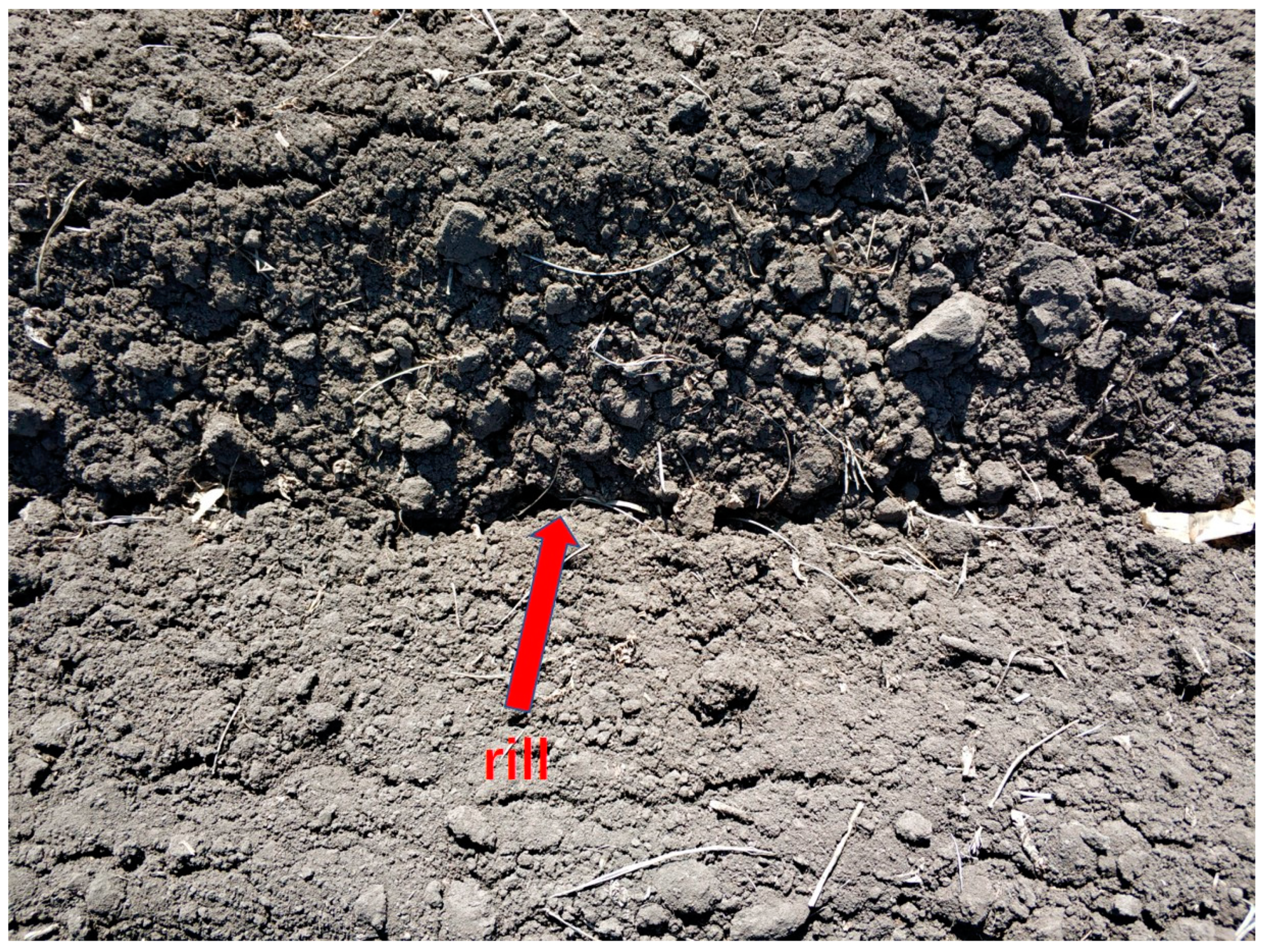
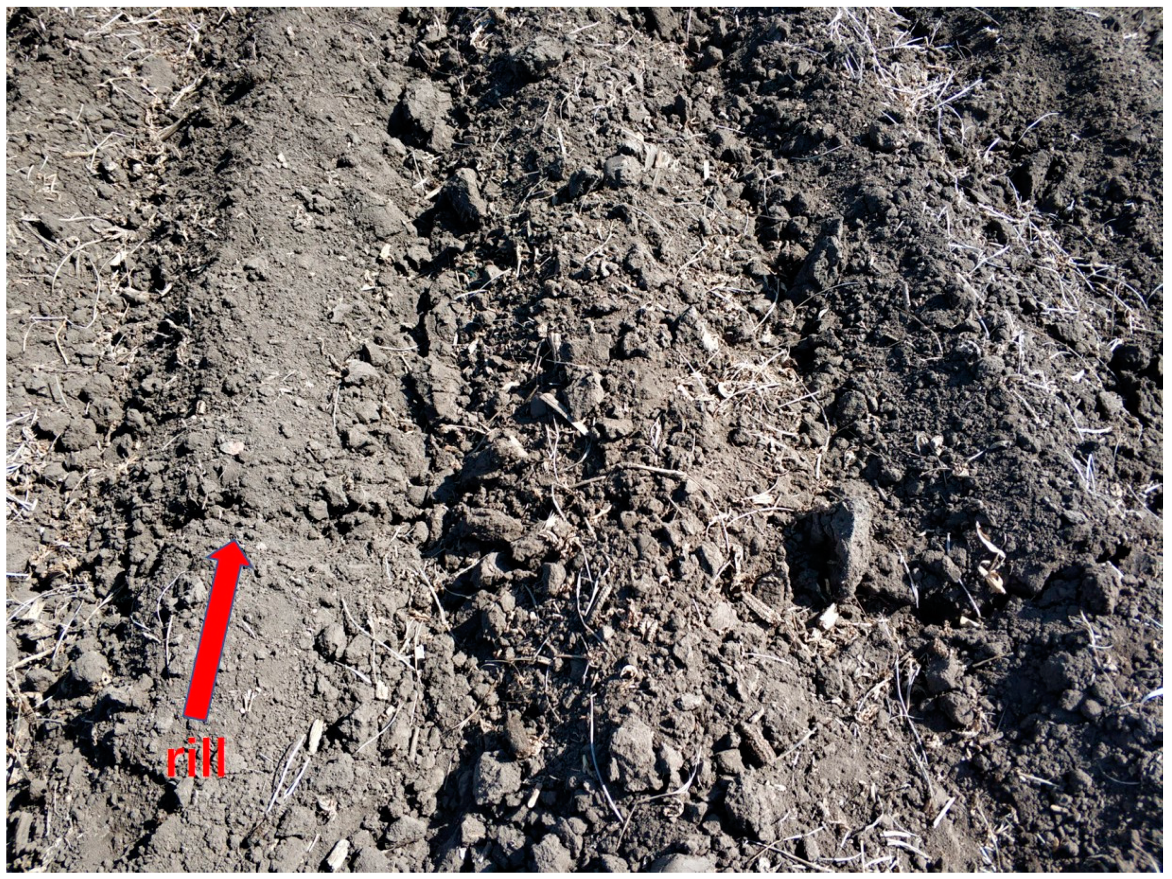
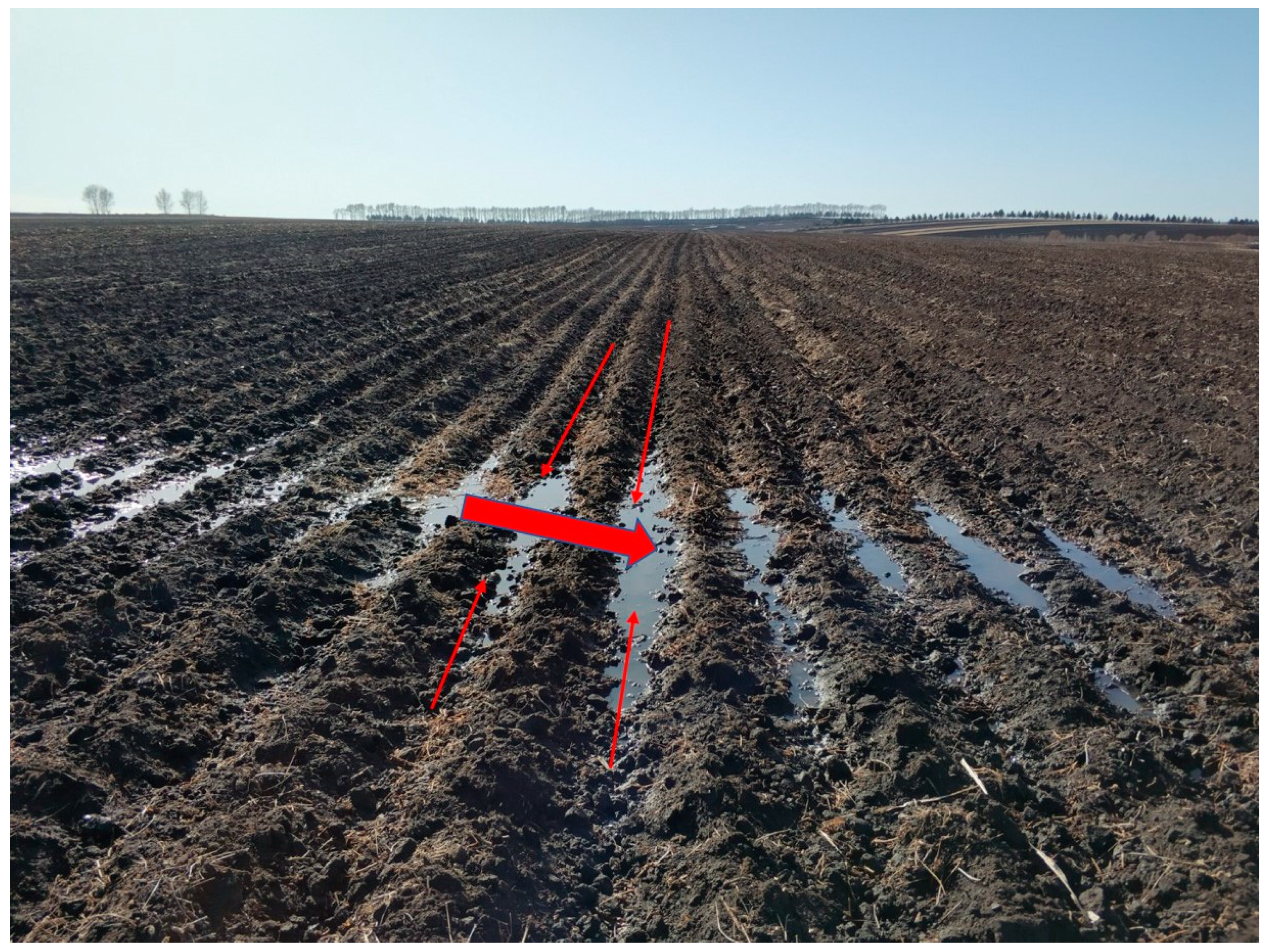
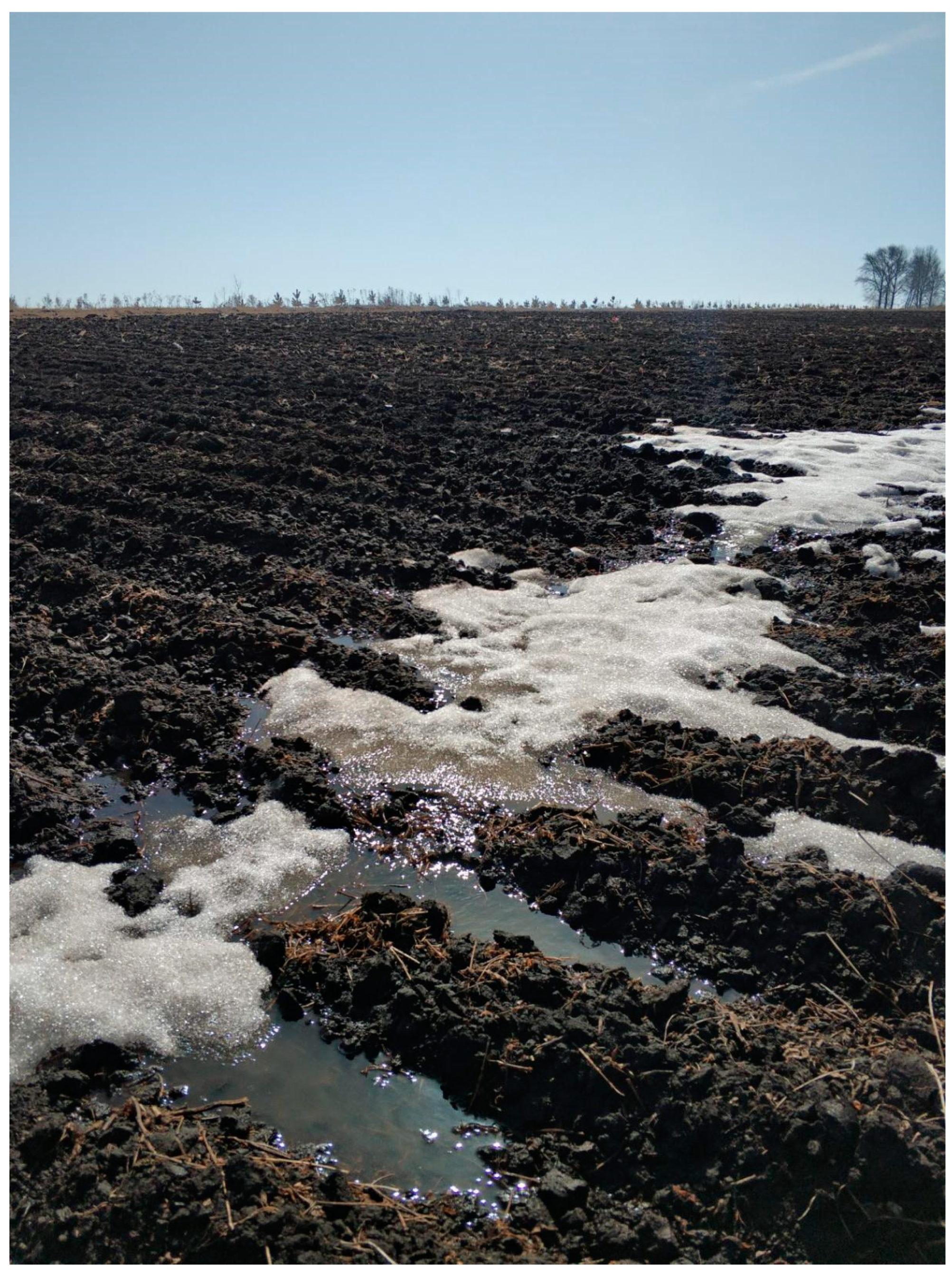
Most rills were observed between 60 and 90 m down-slope from the top. Snow ablation occurred first and faster at the top with shallow snow cover, and the hold capacity of snow cover prevented melted water from converting into runoff. So, rills did not form until enough runoff amount accumulated. The region mentioned above was favorable for rill generation (Figure 7). Rills occurred either along the furrows (Figure 8) or throughout the entire platform (Figure 9) when there was adequate snowmelt discharge and energy. However, in the middle positions, the topography gradually transitioned from flat to inward, leading to the convergence of the snowmelt towards the middle low-lying positions instead of flushing perpendicular to the ridge belt (Figure 10). Consequently, rills were not observed in these positions. These results showed that during the snowmelt period, rills could not generate across the whole slope but only in upper positions, indicating that snowmelt runoff in each event had a limited migration distance, likely due to a small discharge or being disturbed by local topography (Figure 11).
In the downhill section, snowmelt runoff was gradually concentrated in a low-lying position, with the potential to flush down or overflow the ridge platform, when it exceeded the storage capacity of the ridge and furrow system. As the snowmelt process continued, the soil-thawing depth increased, and the accumulated melted water saturated the surface soil, which made the ridge platform much more prone to failure, leading to an increased sediment source and significantly promoting snowmelt erosion across the entire catchment. Consequently, the height of the ridge platform and surface soil thickness would be reduced, while sedimentation would increase in the furrows. This alteration of the local micro-topography would in turn affect the snowmelt erosion process. Therefore, the interaction of these factors contributes to enhanced soil erosion.
The field investigation revealed that different positions had various forms of broken ridges. The reason for this variation was that in some regions, where there was no efficient snowmelt runoff, the ridge platform was not stable. The first phenomenon started 220 m from the top and displayed no horizontal pattern along with the ridge belt. If there was no efficient snowmelt runoff, it could only destroy the unstable position of the ridge platform, such as relatively lower or completely thawed sites (Figure 8), resulting in an uncertain location of broken ridges. On the down-slope, increased snowmelt runoff with high energy had the ability to break ridge platforms with deeper thawing depths. When the ridge and furrow system could not withstand the force, snowmelt runoff would either overflow or break through the platform, accompanied by a collapse somewhere. Consequently, an obvious flow route near the outlet was generated by scouring and flushing, and the scope of ridge collapse was further expanded (Figure 12). Furthermore, the soil along both sides of the flow path within the ridge belt was eroded and carried away by runoff, resulting in a visible cutting-down phenomenon. The erosion near the outlet represented a typical transition from rill erosion to ephemeral gully erosion.
The spatial distribution patterns of snowmelt are critical issues in the prevention and control of different types of soil erosion. Suitable tillage methods have been proven effective in mitigating soil and total phosphorus loss during sheet erosion and rill erosion [22]. Gully erosion would bring much more harm to land [17], while some soil conservation measurements, such as grassed waterways and check dams, have proved to be useful in gully control. Snowmelt erosion exhibits distinct characteristics when compared to rain-fall-induced erosion. Therefore, it is important to conduct further observations of snowmelt erosion at various spatial and temporal scales to gain deeper insights into its underlying mechanisms. Furthermore, additional investigations should focus on evaluating the effectiveness of established traditional soil conservation measures and exploring enhanced techniques to augment their efficiency. Such endeavors are imperative for advancing our understanding and management of snowmelt-induced erosion effectively.

4. Conclusions

Seasonal snowmelt erosion is a complex composite erosion process that requires the fulfillment of several critical conditions. The occurrence of snowmelt erosion relies on the presence of a large amount of accumulated snow cover, providing a sufficient water amount source. Additionally, the rapid rise in air temperature above the melting point of ice and snow leads to the potential generation of adequate discharge. Thaw of the surface soil occurs when there is sufficient discharge to flush the soil. To minimize infiltration loss in the early stage, the soil freeze depth must reach an adequate level. However, even if snowmelt runoff is observed, the occurrence of snowmelt erosion becomes challenging without meeting these critical conditions. Moreover, snowmelt erosion exhibits high sensitivity to variations in the surrounding environment, such as fluctuations in air temperature and the freeze–thaw action caused by day and night alternation. The original topography also plays a significant role in influencing the erosion process by affecting discharge generation, influx, and sediment sources. Furthermore, the micro-topography reshaped by contour ridge cultivation determines the flow routes and erosion patterns, including the formation and development of rills.

Author Contributions

Conceptualization, H.F. and X.X.; methodology, H.F. and X.X.; software, H.F. and X.X.; validation, H.F., Y.H. and X.X.; formal analysis, X.X.; investigation, Y.H.; resources, H.F. and Y.H.; data curation, Y.H.; writing—original draft preparation, H.F. and Y.H.; writing—review and editing, H.F., X.X., C.M. and H.S.; visualization, X.X.; supervision, H.F.; project administration, H.F.; funding acquisition, H.F. All authors have read and agreed to the published version of the manuscript.

Funding

This research was funded by the National Key Research and Development Program of China (grant number 2021YFD1500701) and the Natural Science Foundation of China (grant numbers 41371272 and 41807062).

Institutional Review Board Statement

Not applicable.

Informed Consent Statement

Not applicable.

Data Availability Statement

Data can be obtained through the email of the corresponding author.

Acknowledgments

We gratefully thank Dichen Wang, Xinyu Guo, Bo Liu, Hongxi Liu, Jingyi Chi, and Tongyao Chen for their help with the observation.

Conflicts of Interest

The authors declare no conflict of interest.

References

  1. Lana-Renault, N.; Alvera, B.; García-Ruiz, J.M. Runoff and Sediment Transport during the Snowmelt Period in a Mediterranean High-Mountain Catchment. Arct. Antarct. Alp. Res. 2018, 43, 213–222. [Google Scholar] [CrossRef]
  2. Gusarov, A.V. The impact of contemporary changes in climate and land use/cover on tendencies in water flow, suspended sediment yield and erosion intensity in the northeastern part of the Don River basin, SW European Russia. Environ. Res. 2019, 175, 468–488. [Google Scholar] [CrossRef]
  3. Zhang, L.; Ren, F.P.; Li, H.; Cheng, D.B.; Sun, B.Y. The Influence Mechanism of Freeze-Thaw on Soil Erosion: A Review. Water 2021, 13, 1010. [Google Scholar] [CrossRef]
  4. Zeinivand, H.; De Smedt, F. Hydrological Modeling of Snow Accumulation and Melting on River Basin Scale. Water Resour. Manag. 2009, 23, 2271–2287. [Google Scholar] [CrossRef]
  5. Panuska, J.C.; Karthikeyan, K.G. Phosphorus and organic matter enrichment in snowmelt and rainfall-runoff from three corn management systems. Geoderma 2010, 154, 253–260. [Google Scholar] [CrossRef]
  6. Yakutina, O.P.; Nechaeva, T.V.; Smirnovi, N.V. Consequences of snowmelt erosion: Soil fertility, productivity and quality of wheat on Greyzemic Phaeozem in the south of West Siberia. Agr. Ecosyst. Environ. 2015, 200, 88–93. [Google Scholar] [CrossRef]
  7. Liu, X.; Zhang, Y.; Zhang, L.; Fang, X.; Deng, W.; Liu, Y. Aggregate-associated soil organic carbon fractions in subtropical soil undergoing vegetative restoration. Land Degrad. Dev. 2023. [Google Scholar] [CrossRef]
  8. Lu, Y.F.; Liu, C.; Ge, Y.; Hu, Y.L.; Wen, Q.; Fu, Z.L.; Wang, S.B.; Liu, Y. Spatiotemporal Characteristics of Freeze-Thawing Erosion in the Source Regions of the Chin-Sha, Ya-Lung and Lantsang Rivers on the Basis of GIS. Remote Sens. 2021, 13, 309. [Google Scholar] [CrossRef]
  9. Fan, H.M.; Liu, Y.J.; Xu, X.Q.; Wu, M.; Zhou, L.L. Simulation of rill erosion in black soil and albic soil during the snowmelt period. Acta Agric. Scand. Sect. B Soil Plant Sci. 2017, 67, 510–517. [Google Scholar] [CrossRef]
  10. Komissarov, M.A.; Gabbasova, I.M. Snowmelt-induced soil erosion on gentle slopes in the southern Cis-Ural region. Eurasian. Soil Sci. 2014, 47, 598–607. [Google Scholar] [CrossRef]
  11. Zhai, J.B.; Zhang, Z.; Melnikov, A.; Zhang, M.Y.; Yang, L.Z.; Jin, D.D. Experimental Study on the Effect of Freeze-Thaw Cycles on the Mineral Particle Fragmentation and Aggregation with Different Soil Types. Minerals 2021, 11, 913. [Google Scholar] [CrossRef]
  12. Ulén, B.; Bechmann, M.; Øygarden, L.; Kyllmar, K. Soil erosion in Nordic countries—Future challenges and research needs. Acta Agric. Scand. Sect. B Soil Plant Sci. 2012, 62, 176–184. [Google Scholar] [CrossRef]
  13. Shi, X.N.; Zhang, F.; Wang, L.; Jagirani, M.D.; Zeng, C.; Xiao, X.; Wang, G.X. Experimental study on the effects of multiple factors on spring meltwater erosion on an alpine meadow slope. Int. Soil. Water Conse 2020, 8, 116–123. [Google Scholar] [CrossRef]
  14. Xiao, X.; Liu, Z.; Liu, K.S.; Wang, J.Q. Temporal Variation of Suspended Sediment and Solute Fluxes in a Permafrost-Underlain Headwater Catchment on the Tibetan Plateau. Water 2022, 14, 2782. [Google Scholar] [CrossRef]
  15. Starkloff, T.; Stolte, J.; Hessel, R.; Ritsema, C.; Jetten, V. Integrated, spatial distributed modelling of surface runoff and soil erosion during winter and spring. Catena 2018, 166, 147–157. [Google Scholar] [CrossRef]
  16. Barneveld, R.J.; van der Zee, S.E.A.T.M.; Stolte, J. Quantifying the dynamics of microtopography during a snowmelt event. Earth Surf. Proc. Land 2019, 44, 2544–2556. [Google Scholar] [CrossRef]
  17. Xu, J.Z.; Li, H.; Liu, X.B.; Hu, W.; Yang, Q.N.; Hao, Y.F.; Zhen, H.C.; Zhang, X.Y. Gully Erosion Induced by Snowmelt in Northeast China: A Case Study. Sustainability 2019, 11, 2088. [Google Scholar] [CrossRef] [Green Version]
  18. Du, P.F.; Huang, D.H.; Liu, B.; Qin, W. Using Source Fingerprinting Techniques to Investigate Sediment Sources during Snowmelt and Rainfall Erosion Events in a Small Catchment in the Black Soil Region of Northeast China. Land 2023, 12, 542. [Google Scholar] [CrossRef]
  19. Zhou, Y.; Xu, Y.; Xiao, W.; Wang, J.; Huang, Y.; Yang, H. Climate Change Impacts on Flow and Suspended Sediment Yield in Headwaters of High-Latitude Regions—A Case Study in China’s Far Northeast. Water 2017, 9, 66. [Google Scholar] [CrossRef] [Green Version]
  20. Fu, Q.Y.; Meng, F.X.; Zhang, Y.; Wang, Z.L.; Li, T.X.; Hou, R.J. Ameliorating Effects of Soil Aggregate Promoter on the Physicochemical Properties of Solonetzes in the Songnen Plain of Northeast China. Sustainability 2022, 14, 5747. [Google Scholar] [CrossRef]
  21. Zhu, M.; Yu, X.; Li, Z.; Xu, X.; Ye, Z. Quantifying and interpreting the hysteresis patterns of monthly sediment concentration and water discharge in karst watersheds. J. Hydrol. 2023, 618, 129179. [Google Scholar] [CrossRef]
  22. Skøien, S.E.; Børresen, T.; Bechmann, M. Effect of tillage methods on soil erosion in Norway. Acta Agric. Scand. Sect. B Soil Plant Sci. 2012, 62, 191–198. [Google Scholar] [CrossRef]
  23. Yu, P.F.; Li, T.X.; Fu, Q.; Liu, D.; Hou, R.J.; Zhao, H. Effect of Biochar on Soil and Water Loss on Sloping Farmland in the Black Soil Region of Northeast China during the Spring Thawing Period. Sustainability 2021, 13, 1460. [Google Scholar] [CrossRef]
  24. IA Ahmed, A.; MEldoma, I.; AHElaagip, E.E.; Hou, F. Effects of Indigenous Cultivation Practices on Soil Conservation in the Hilly Semiarid Areas of Western Sudan. Water 2020, 12, 1554. [Google Scholar] [CrossRef]
  25. Li, H.L.; Shen, H.O.; Wang, Y.; Wang, Y.; Gao, Q. Effects of Ridge Tillage and Straw Returning on Runoff and Soil Loss under Simulated Rainfall in the Mollisol Region of Northeast China. Sustainability 2021, 13, 10614. [Google Scholar] [CrossRef]
  26. Williams, G.P. Sediment concentration versus water discharge during single hydrologic events in rivers. J. Hydrol. 1989, 111, 89–106. [Google Scholar] [CrossRef]
  27. Costa, A.; Molnar, P.; Stutenbecker, L.; Bakker, M.; Silva, T.A.; Schlunegger, F.; Lane, S.N.; Loizeau, J.L.; Girardclos, S. Temperature signal in suspended sediment export from an Alpine catchment. Hydrol. Earth Syst. Sci. 2018, 22, 509–528. [Google Scholar] [CrossRef] [Green Version]
  28. Wang, T.; Li, P.; Liu, Y.; Hou, J.M.; Li, Z.B.; Ren, Z.P.; Cheng, S.D.; Zhao, J.H.; Hinkelmann, R. Experimental investigation of freeze-thaw meltwater compound erosion and runoff energy consumption on loessal slopes. Catena 2020, 185, 104310. [Google Scholar] [CrossRef]
  29. Wu, Y.Y.; Ouyang, W.; Hao, Z.C.; Yang, B.W.; Wang, L. Snowmelt water drives higher soil erosion than rainfall water in a mid-high latitude upland watershed. J. Hydrol. 2018, 556, 438–448. [Google Scholar] [CrossRef]
  30. Hua, W.; Fan, H.; Xiuquan, X.U.; Jia, Y.; Liu, Y.; Tan, J.; Zhang, N. Observation on the Spring Snowmelt Erosion of Sloping Farmland in Northeast China. J. Soil Water Conserv. 2017, 31, 92–96. [Google Scholar] [CrossRef]
  31. Gonzales-Inca, C.; Valkama, P.; Lill, J.O.; Slotte, J.; Hietaharju, E.; Uusitalo, R. Spatial modeling of sediment transfer and identification of sediment sources during snowmelt in an agricultural watershed in boreal climate. Sci. Total Environ. 2018, 612, 303–312. [Google Scholar] [CrossRef]
  32. Vale, S.S.; Dymond, J.R. Interpreting nested storm event suspended sediment-discharge hysteresis relationships at large catchment scales. Hydrol. Process. 2019, 34, 420–440. [Google Scholar] [CrossRef]
  33. Hamshaw, S.D.; Dewoolkar, M.M.; Schroth, A.W.; Wemple, B.C.; Rizzo, D.M. A New Machine-Learning Approach for Classifying Hysteresis in Suspended-Sediment Discharge Relationships Using High-Frequency Monitoring Data. Water Resour. Res. 2018, 54, 4040–4058. [Google Scholar] [CrossRef]
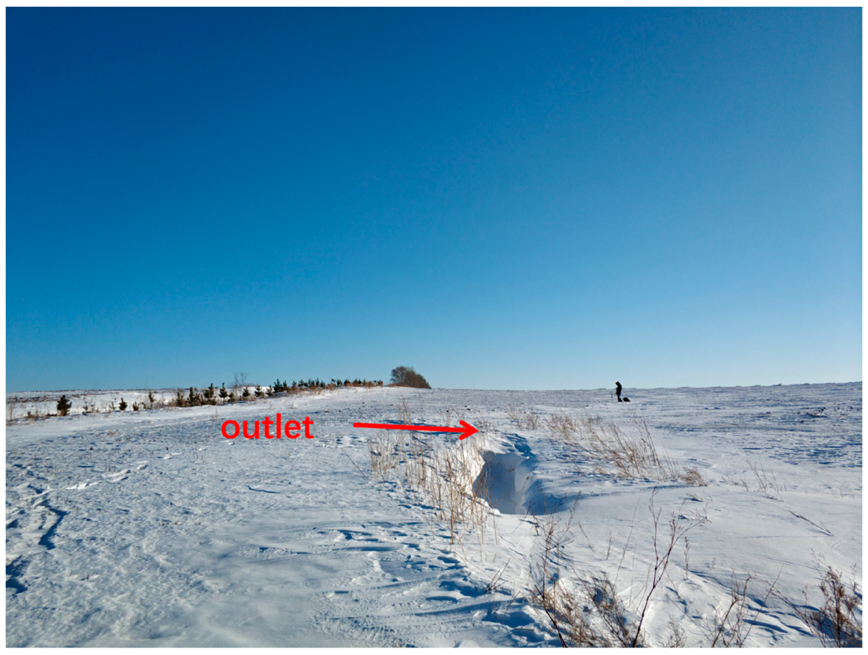
Figure 1. The investigated catchment before snowmelt erosion, with the outlet selected at the head of a gully.
Water 15 02918 g001
Figure 2. Daily average snowmelt runoff and sediment.
Water 15 02918 g002
Figure 3. Daily minimum and maximum air temperatures in March.
Water 15 02918 g003
Figure 4. Response of snowmelt erosion process to variations in air temperature at each event ((ad) are processes on 23 to 26, repreently).
Water 15 02918 g004aWater 15 02918 g004b
Figure 5. Variations in thaw depths of surface soil at upper slope and lower slope.
Water 15 02918 g005
Figure 6. Hysteresis relationship between suspended sediment and snowmelt runoff at each event ((ac) are processes on 23 to 25, repreently).
Water 15 02918 g006
Figure 7. Snowmelt erosion with rills at the upper slope. (The red arrows were traces of flows).
Water 15 02918 g007
Figure 8. A rill along a furrow.
Water 15 02918 g008
Figure 9. A rill through a ridge.
Water 15 02918 g009
Figure 10. Snowmelt erosion at middle position of the catchment with slightly topographic depression. (The red arrows were flow directions).
Water 15 02918 g010
Figure 11. Snow, ice, melt water retained in the ridge, and incompletely thawed surface soil, which reduced infiltration.
Water 15 02918 g011
Figure 12. Snowmelt erosion with an obvious flow route in form of ephemeral gully at the lower slope.
Water 15 02918 g012
Disclaimer/Publisher’s Note: The statements, opinions and data contained in all publications are solely those of the individual author(s) and contributor(s) and not of MDPI and/or the editor(s). MDPI and/or the editor(s) disclaim responsibility for any injury to people or property resulting from any ideas, methods, instructions or products referred to in the content.