Article

Soil Moisture Dynamics and Its Temporal Stability under Different-Aged Caragana korshinskii Shrubs in the Loess Hilly Region of China

1
Institute of Geographical Science, Taiyuan Normal University, Jinzhong 030619, China
2
State Key Laboratory of Urban and Regional Ecology, Research Center for Eco-Environmental Sciences, Chinese Academy of Sciences, Beijing 100085, China
3
University of Chinese Academy of Sciences, Beijing 100049, China
4
International Center for Climate and Global Change Research, School of Forestry and Wildlife Sciences, Auburn University, Auburn, AL 36849, USA
*
Author to whom correspondence should be addressed.
Water 2023, 15(13), 2334; https://doi.org/10.3390/w15132334
Submission received: 12 May 2023 / Revised: 20 June 2023 / Accepted: 21 June 2023 / Published: 23 June 2023
(This article belongs to the Section Soil and Water)

Abstract

:
Soil moisture has a great influence on vegetation growth and survival in arid and semiarid regions. Information about deep soil moisture dynamics is vital for restoring vegetation and improving land management on the water-limited Loess Plateau. The spatiotemporal dynamics and temporal stability of deep soil moisture (at a soil depth of 600 cm) were observed in situ under Caragana korshinskii shrubs that had various stand ages (named CK-10yr, CK-20yr and CK-35yr) in the Loess hilly region of China. The results showed that under C. korshinskii, soil moisture generally decreased as the stand age rose. Meanwhile, its moisture was consistent with precipitation variation, and an obvious time lag in soil moisture was found compared to that in precipitation during the entire growing season. Along the soil profile, a transition belt linking the shallow with deep soil moisture occurred at a 200 cm soil depth in different slope positions and aspects. At the slope scale, both the slope aspect and slope position significantly affected soil moisture variation in the areas with planted C. korshinskii shrubs, experiencing a decreasing trend from semi-shady slopes to sunny ones and from lower positions to upper ones. However, the variance in soil moisture between different positions and slope aspects was small. For the slope aspect, except for CK-20yr, the different-aged C. korshinskii shrubs had higher soil moisture content on sunny slopes than on semi-shady slopes at the upper 0–200 cm soil depth, while the opposite was true at the 200–600 cm soil depths. For slope positions, the soil moisture variation was small between the 0 and 200 cm soil depths and larger between the 200 and 600 cm soil depths. Within the whole profiles, the representative depth under the C. korshinskii shrubs for the soil moisture content was mainly concentrated between the 400–500 cm soil depths, on average, showing a gradual deepening trend with increasing restoration age. In summary, the findings indicate that natural recovery with low-water consumption grasslands and manual management measures, such as thinning and mowing, should be strengthened to minimize the high soil moisture consumption rates that occur in a healthy soil moisture environment and maintain sustainable vegetation restoration.

1. Introduction

Soil moisture is recognized as a basic resource for the sustainable development of terrestrial ecosystems and can even determine the recovery time of ecosystems after drought disturbance [1]. As the main source of plant water on the Loess Plateau, soil moisture is also the main limiting factor in maintaining ecosystems in arid and semiarid areas. It plays a central and important role in the soil-vegetation-atmosphere system, as well as hydrological, ecological and biological processes [2,3,4]. However, inappropriate afforestation efforts in water-limited regions have had negative effects on soil moisture, such as large-scale soil desiccation and groundwater storage reduction [5,6], which have seriously affected the land water cycle process and constrained the sustainable growth of plants on the Loess Plateau [7,8]. Therefore, studying the spatial and temporal dynamics of soil moisture as well as its eco-hydrological processes in planted plantations is essential for ensuring the stability of terrestrial ecosystems.
Recent studies have focused on the spatiotemporal dynamics and spatial variability in soil moisture, from in situ studies to spatial monitoring, focusing on topics such as influencing factors of the spatiotemporal variability in soil moisture and its scale influence during the whole growing season [9]. In addition to the obvious temporal dynamics of soil moisture with precipitation, the soil moisture’s distribution varies little as time goes by spatially, and at a given measured position, it can approximatively represent the average values over an entire profile, which is called the temporal stability of soil moisture [10] and it provides convenient conditions to predict the soil moisture as a whole [11,12,13,14]. Since this method was proposed, it has been widely used, especially in areas with relatively scarce water resources on the Loess Plateau [15,16]. However, relevant studies largely concentrate on shallow soil moisture, and few studies have focused on the temporal stability of soil moisture in deeper soil profiles. Thus, knowledge of the spatiotemporal dynamics and temporal stability of deep soil moisture at the slope scale can provide an effective basis for selecting representative sample points and sampling depths for regional soil moisture monitoring. It is also of special significance for managing soil water resources in both arid and semiarid regions.
Owing to natural factors as well as anthropogenic ones, the Loess Plateau is one of the most severely erodible places among all globe areas [17]. Thus, the government has conducted numerous efforts since the 1950s to restore the fragile ecological environments in this area, including the Grain for Green Program, the Natural Forest Protection Program, the Beijing-Tianjin Sandstorm Source Control Project, and the Three-North Shelter Forest Program [18]. Following the implementation of these afforestation projects, most of the cultivated lands on the steep slopes have been converted into forests, shrubs and grasses. Because of its adaptability to high temperatures and drought, Caragana korshinskii has become the main shrub type used for constructing plantations on the Loess Plateau. By 2017, the planted area of C. korshinskii shrubs on the Loess Plateau was approximately 1.33 × 10⁶ hm2, and this shrub was widely distributed in Gansu, Ningxia, northwestern Shaanxi and northwestern Shanxi [19,20]. A large number of studies indicate that C. korshinskii plays ecological roles in soil and water conservation, sand fixation and wind breaking in this area [21,22]. However, due to their well-developed root systems, C. korshinskii shrubs consume more water from deep soil layers than from other layers, which exacerbates the deterioration of the soil moisture environment, leading to severe soil desiccation and a gradual decline in C. korshinskii plantations [3,23,24]. Thus, it is essential to analyze the spatiotemporal dynamics and temporal stability of soil moisture to better understand the relationships between C. korshinskii shrub growth and the soil moisture environment. The findings of this study are important for policy makers and scientific researchers.

2. Materials and Methods

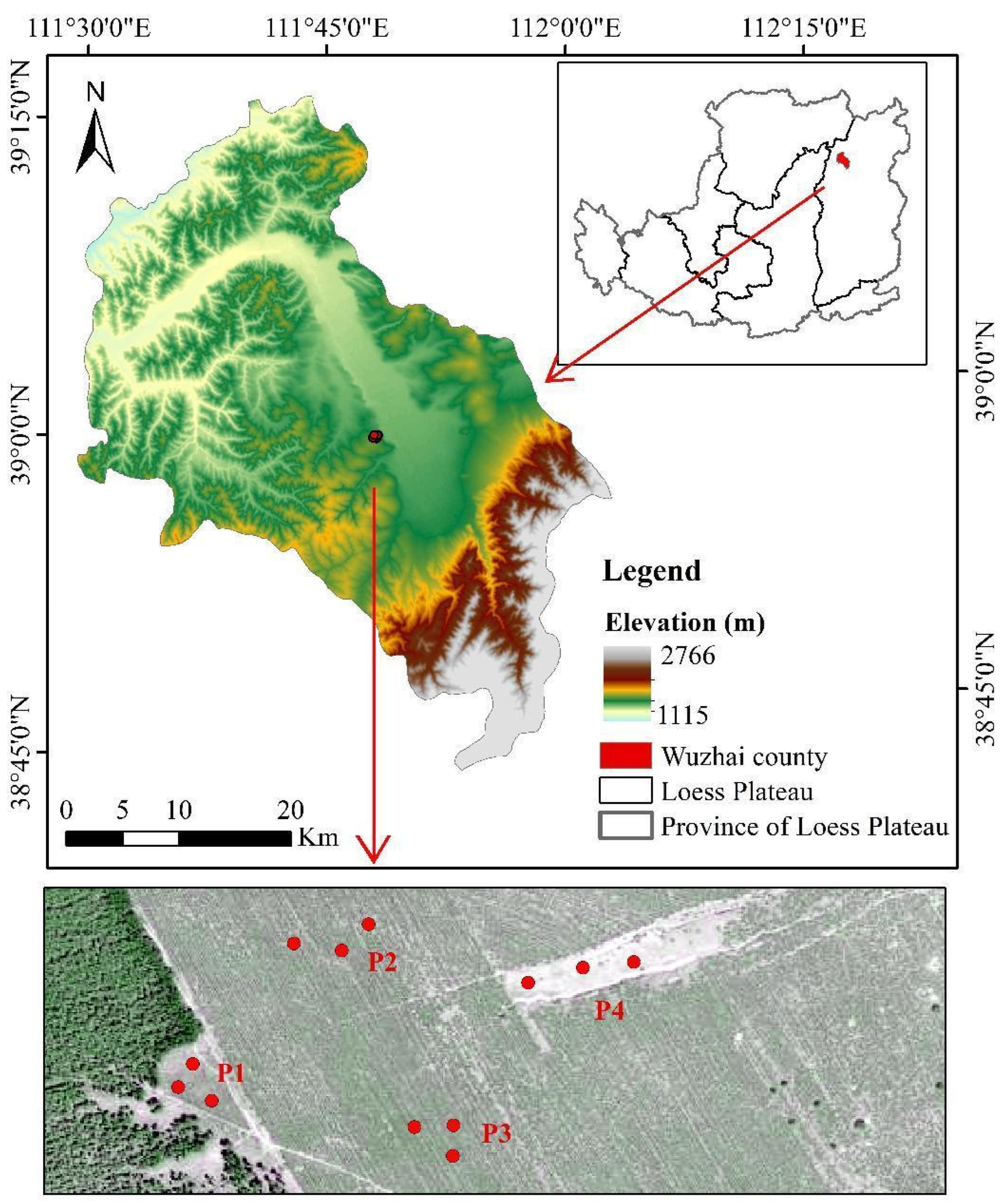
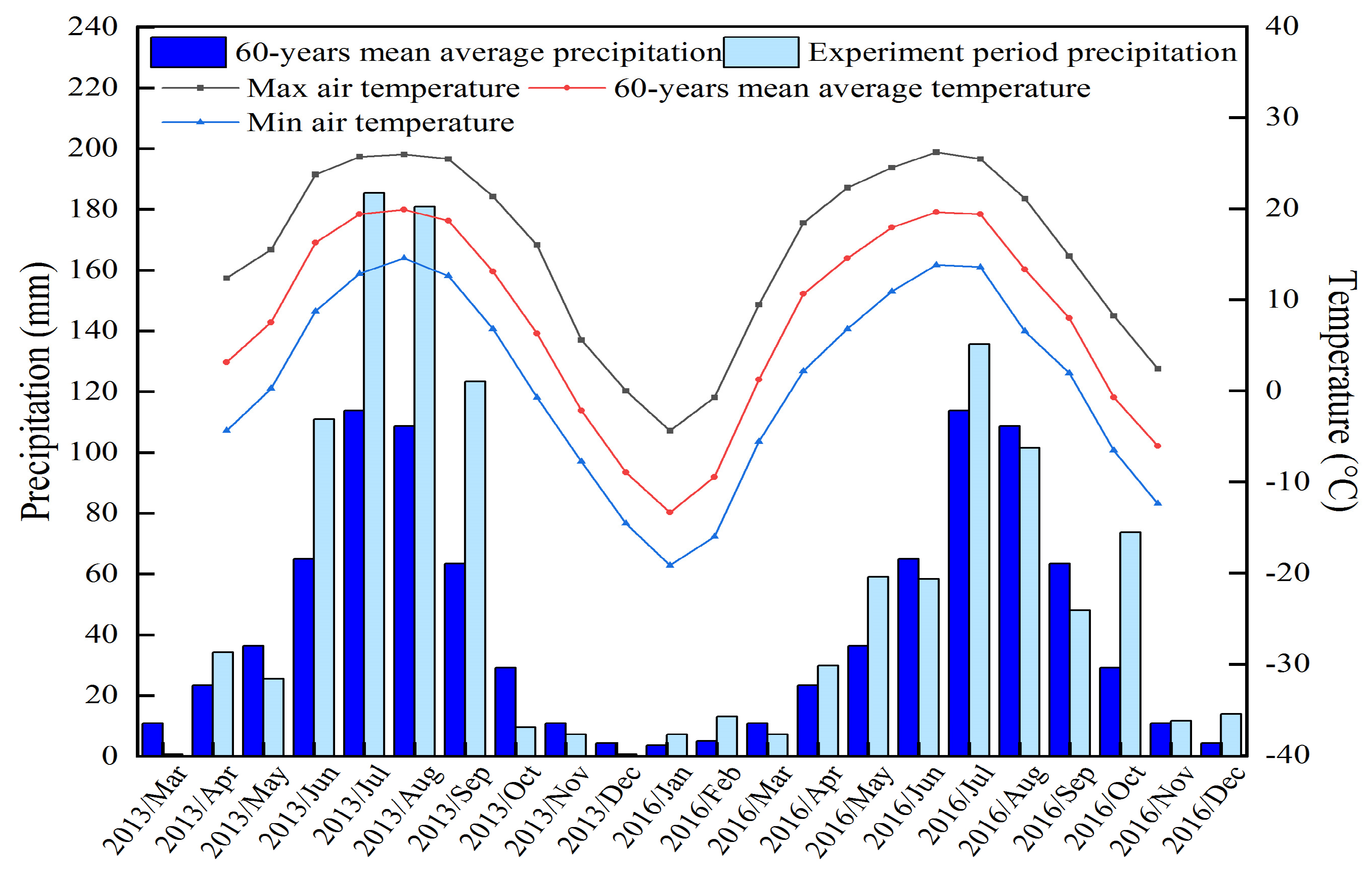
2.1. Introduction to the Studied Area

The field site (111.77° E, 38.98° N, 1448 m a.s.l.), named the Zhangjiaping Forestry Center, is situated in the northern part of the Loess Plateau in Shanxi Province, China (Figure 1). This region is dominated by a typical continental monsoon climate, with warm and wet summers and dry and cold winters [25]. According to the records of the local meteorological stations, the average annual temperature and precipitation are 4.8 °C and 478.5 mm, respectively. A large proportion of the precipitation (60–70%) falls between June and September, with high-intensity and short-duration storms, and its annual variability is large, especially in the growing seasons (Figure 2). In addition, the mean annual pan evaporation is relatively high, accounting for approximately 1784.4 mm. The area belongs to a typical hilly gully region, with elevations ranging from 1397 to 1533 m. The soil in the region has low fertility, with 1.25% clay, 33.1% silt and 65.65% sand [26]. The current land use types are rain-fed croplands, forestlands, shrublands and native grasslands. The dominant vegetation types are Caragana korshinskii Kom., Populus simonii Carr., and Pinus tabuliformis Carriere. Moreover, grasslands have naturally grown on the land after croplands were abandoned. The main characteristics of the sampling sites are shown in Table 1.

2.2. Experimental Design and Soil Sampling

At the experimental field station, continuous soil moisture observation experiments were conducted in C. korshinskii shrub plots with different stand ages. In this paper, two different precipitation years, 2013 (668 mm during the growing season) and 2016 (503.9 mm during the growing season), were selected to analyze the temporal dynamic process of soil moisture. The annual precipitation during the two years is shown in Figure 2. To prevent the influence of soil texture and extra environmental factors, all C. korshinskii sampling sites (namely, CK-10yr, CK-20yr and CK-35yr, which represented 10-year-old C. korshinskii, 20-year-old C. korshinskii and 35-year-old C. korshinskii, respectively) and the control plot (namely, abandoned land) were located at similar elevations for the same slope position and at a distance of less than 500 m from each site (Figure 1). Each sampling period lasted between 2 and 3 days, and no precipitation occurred during the sampling period to avoid the influence of precipitation on the soil moisture. The restoration years of the C. korshinskii stands were obtained from the planting records of Zhangjiaping Forestry and by asking local residents [25]. A GPS receiver (5 m precision) was used to locate the sampling sites with longitude, latitude and altitude. A geological compass was used to determine the slope gradient, position and aspects. Climate data, such as temperature and precipitation, were collected from the national weather station two kilometers away from the experimental station.
Soil samples were gathered from a depth of 600 cm at each site at an interval of 10 cm using a soil auger (5 cm in diameter). In total, 60 samples were collected from one site. After collection, the gravimetric soil moisture content was determined immediately by means of the oven-drying method (105 °C to a constant weight). Subsamples of disturbed soil were air-dried and sieved through a 1-mm mesh to analyze soil particle composition by laser diffraction with a Mastersizer 3000 (Malvern Instruments, Malvern, England). Undisturbed soil cores were also gathered from a depth of 100 cm using cutting rings (5 cm in diameter, 5 cm in height) to measure soil bulk density (BD) and other physical characteristic parameters.
In addition, a vegetation survey was performed during the vigorous growth period (July to August), and the plant height and crown width of C. korshinskii plantations with different stand ages were measured. Since all of the C. korshinskii shrubs were planted, with uniform plant spacing and row spacing, the measured number of plants was the same (7500 plants/ha).

2.3. Data Analysis

The following calculates the gravimetric soil moisture content (SMC):
S M C = G 1 G 2 G 2 G 100 %
where SMC serves as the gravimetric soil moisture content (%), G represents the weight of the empty aluminum box (g), G1 and G2 are the total weight before and after drying, respectively (g).
Relative difference (RD) was applied to explore the temporal stability of deep soil moisture under C. korshinskii shrubs of various stand ages [26]. Within a certain point, the relative difference value (RDij) of the ith soil layer at the jth period was calculated as follows:
R D i j = S M C i j S M C j ¯ S M C j ¯
where SMCij represents the soil moisture content of the ith soil layer during the jth period. S M C j ¯ refers to the mean soil moisture content at the jth period across the whole profile, which was calculated as follows:
S M C j ¯ = 1 n i = 1 n S M C i j
where n numbers the soil layers. In our study, the sampling interval was 10 cm, and the whole 0–600 cm soil profile was divided into 60 layers (n = 60).
At each site, the mean relative difference (MRD) and standard deviation of the relative difference (SDRD) of soil moisture along a time sequence were calculated as follows [26]:
M R D i = 1 m j = 1 m R D i j
S D R D i = 1 m 1 j = 1 m ( R D i j M R D i ) 2
where m represents the number of soil moisture measurements. In this paper, soil moisture was measured 13 times in total in 2013 and 2016 (m = 13).
The relative difference method was mainly used to determine the variability in soil moisture within the soil profiles over time. For example, during the observation period, when the MRD value of the SMC in the soil layer was equal to or close to 0 and the corresponding SDRD was small, the difference between the SMC of one soil layer and the average profile SMC was smaller; that is, the SMC in this layer could be used as a representative of the profile soil moisture content.

3. Results

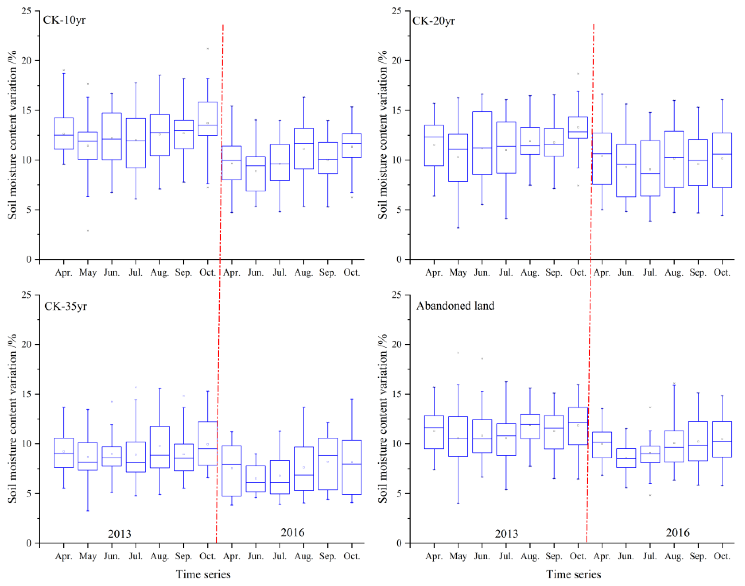
3.1. Temporal Dynamics of Soil Moisture under Caragana korshinskii Shrubs

The study found that the soil moisture under the planted C. korshinskii shrubs was consistent with the annual precipitation pattern. As precipitation decreased, soil moisture under C. korshinskii of various ages also gradually decreased, showing a downward trend, followed by increasing (stabilizing) changes throughout the year (Figure 3). According to the precipitation records in the different experimental years in the study area, the precipitation in 2013 was 682.2 mm, while in 2016, it was 20% lower at 556.8 mm (Figure 2). Taking CK-10yr as an example, the average soil moisture content during the growing season was 12.47% in 2013. Due to the reduction in precipitation, the average soil moisture content dropped to 10.10% in 2016, a reduction of 20%. With the decrease in precipitation, soil moisture in CK-20yr, CK-35yr and abandoned land decreased by 15.40%, 18.89% and 12.96%, respectively (Figure 3).
Within a single growing season, the soil moisture under the planted C. korshinskii shrubs increased with increasing precipitation. However, there was an obvious time lag in the soil moisture content compared to that in the precipitation period. For instance, in the CK-10yr plot, although the heaviest precipitation occurred in July (184.8 mm) during the growing periods of 2013 (Figure 2), the average soil moisture content in August (12.58%) was higher than that in July (12.01%) (Figure 3). Similarly, during the 2016 growing season, although July and August had precipitation of 135.6 mm and 100.3 mm, respectively, the average soil moisture content in August was almost 15.37% higher than that in July. The study also observed similar soil moisture variation trends in the CK-20yr and CK-35yr shrublands and the control abandoned land.

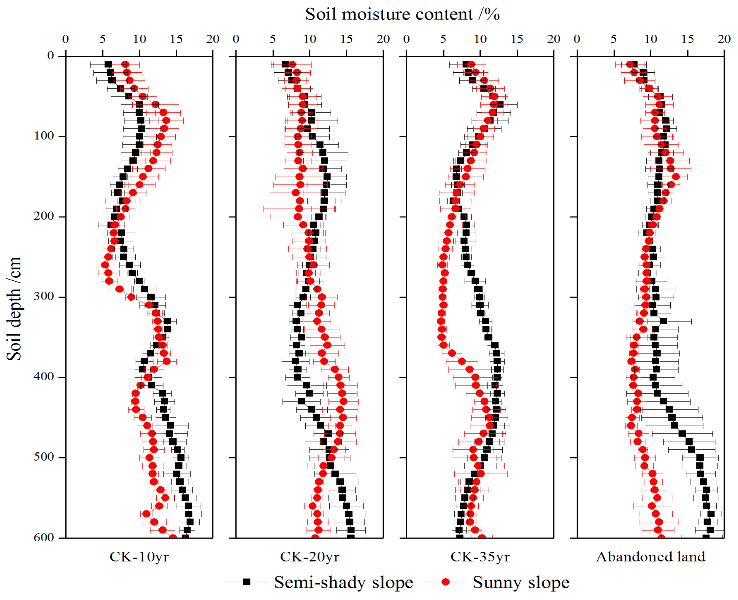
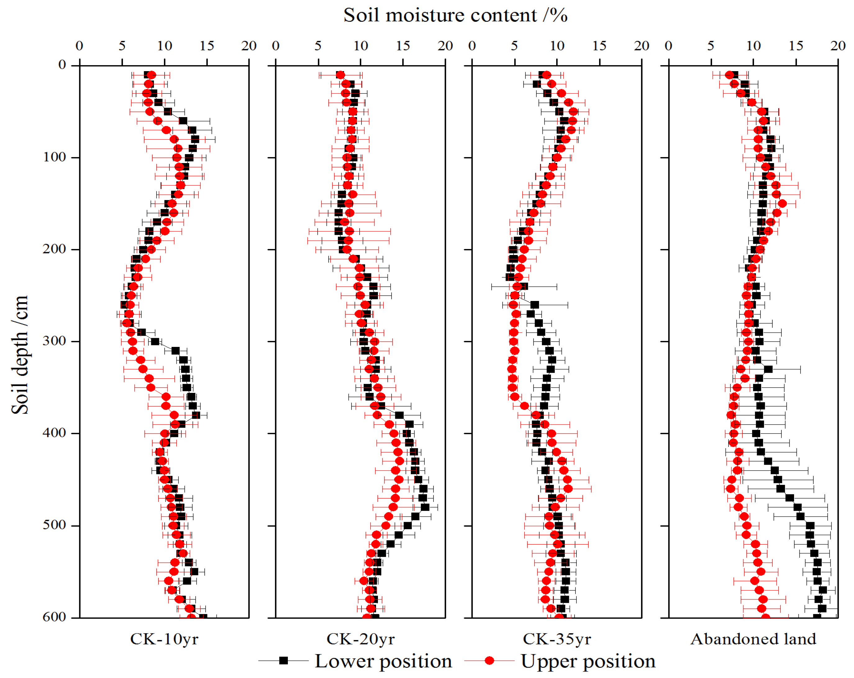
3.2. Soil Moisture Variations with Slope Aspects under Caragana korshinskii Shrubs

The study found that soil moisture under the different-aged C. korshinskii shrubs varied with the slope aspect. Overall, the semi-shady slopes had higher soil moisture than the sunny slopes, but the difference between the slope aspects was small (Figure 4). For example, in the CK-10yr plantations, the average soil moisture content on the semi-shady slope was 11.25%, while that on the sunny slope was 10.59%, with a difference of 0.66%, which was 6.2% higher than that on the semi-shady slope. In the CK-20yr and CK-35yr shrub plots, the soil moisture on the semi-shady slopes was 7.8% and 16.8% higher than that on the corresponding sunny slopes, respectively. In the control abandoned land, the average soil moisture content on the semi-shady slopes turned to be 25.3% overrunning that on the sunny slope, with average soil moisture contents of 12.20% and 9.74% for the semi-shady and sunny slopes, respectively. Additionally, the experiment also revealed that the 200 cm soil layer was a critical point in the soil moisture profile in varying slope sections of the different-aged C. korshinskii stands. Except for the CK-20yr plot, soil moisture above the 200 cm soil layer was higher on the sunny slope than on the semi-shady slope in the C. korshinskii stands and the control abandoned land, while the opposite was true in the 200–600 cm soil layers. For example, the average soil moisture contents of the semi-shady slope and the sunny slope in the 0–200 cm soil layer of the CK-10yr plot were 8.29% and 10.61%, respectively, and the latter was approximately 28.0% higher than that of the semi-shady slope. In the 200–600 cm soil layer, the average soil moisture content was 12.72% on the semi-shady slope, which was approximately 20.2% higher than that on the sunny slope at 10.58%. However, for the CK-20yr plot, in the 0–200 cm soil layer, the average soil moisture content on the semi-shady slope was 21.2%, exceeding that on the sunny slope, with soil moisture contents of 10.4% and 8.58%, respectively. In the deep 200–600 cm soil layer, the soil moisture content on the sunny slope was 7.4%, exceeding that on the semi-shady slope.

3.3. Soil Moisture Variations along Slope Positions under Caragana korshinskii Shrubs

Overall, the soil moisture content of the varying-aged C. korshinskii plantations changed with slope positions and was higher at the lower slope position than at the upper slope position, with small differences among the different slope positions (Figure 5). For example, in the CK-10yr shrubland, the average soil moisture contents at the lower and upper slope positions were 10.59% and 9.62%, respectively, which were approximately 10.08% higher than those at the upper slope profile. In the 20-yr and 35-yr C. korshinskii plantations, the soil water content in the lower slope profile, on average, was 6.59% and 5.12% higher than that in the upper slope profile, respectively. In the CK-20yr and CK-35yr plots, the average soil moisture content in the lower slope profile was 6.59% and 5.12% higher than that in the upper slope profile. However, the average soil moisture content was significantly different between the upper and lower slopes in abandoned land. The soil moisture content of the lower slope site was 25.26% higher than that of the upper slope site, with corresponding average soil moisture contents of 12.20% and 9.74%, respectively. In general, the soil moisture content decreased as the growth age increased, with a sequence of CK-20yr > CK-10yr > abandoned land > CK-35yr plantations. Similarly, soil moisture in different slope profiles was generally bounded to the soil layer at a depth of 200 cm and its difference in soil moisture gradually expanded within the 200–600 cm soil layer among these sampling sites.

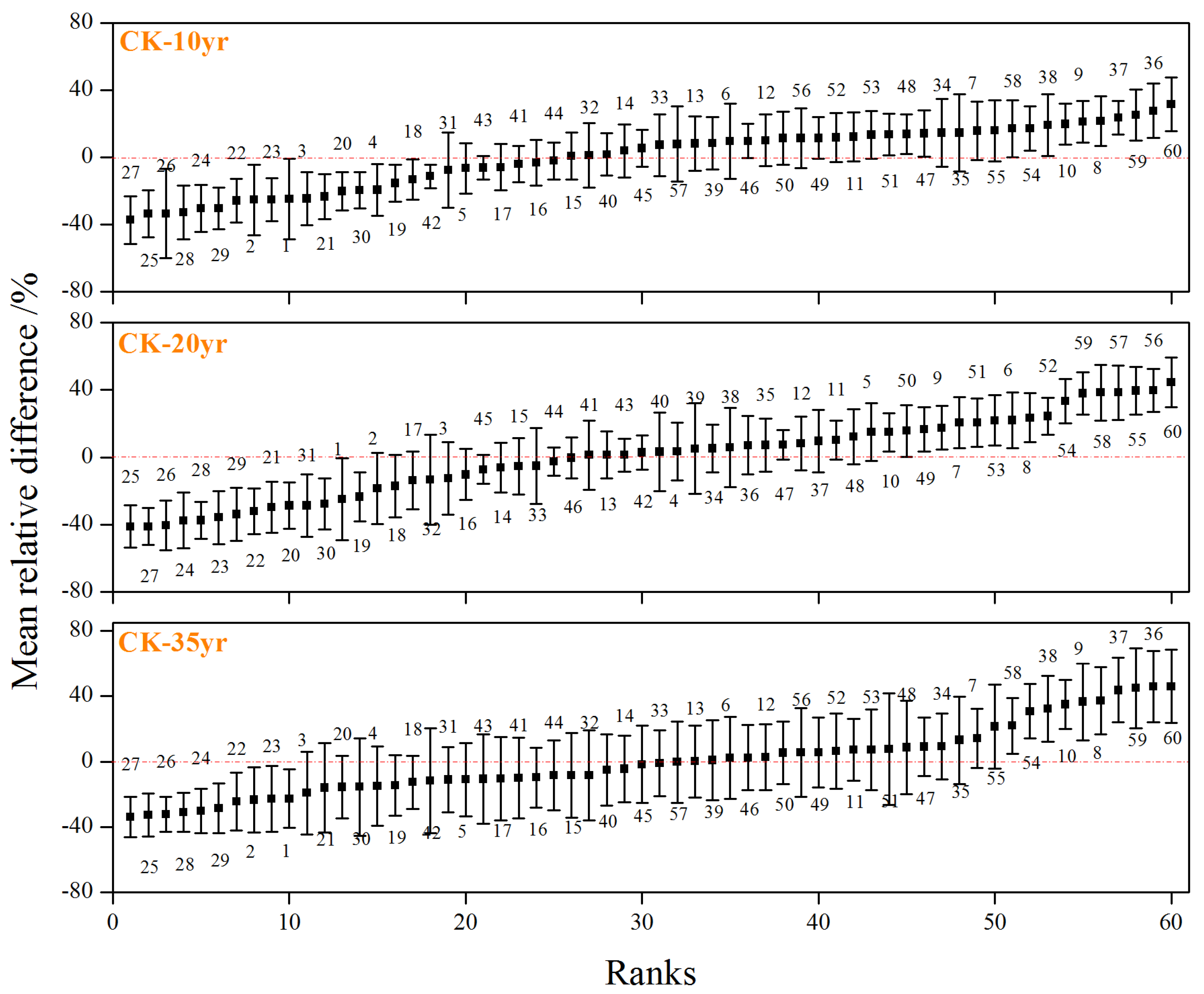
3.4. Temporal Stability of Soil Moisture under Caragana korshinskii Shrubs

Figure 6 presents the relative difference values of profile SMC in the 0–600 cm soil layers of the 10-yr, 20-yr and 35-yr C. korshinskii shrubs. The mean relative difference (MRD) of the SMC in different soil layers in the study area ranged from −37.12% to 31.82% (CK-10yr), −41.38% to 44.68% (CK-20yr), and −34.01% to 46.11% (CK-35yr). The MRD of the soil moisture content in the CK-20yr plantation was the largest, and that in the CK-10yr plantation was the smallest. The mean standard deviation of relative difference (SDRD) of soil moisture in different-aged C. korshinskii stands was 15.03%, 15.66% and 21.51%, respectively, indicating that soil moisture in CK-35yr stands fluctuated greatly with time series, followed by the CK-20yr stands. However, the SMC of CK-10yr was relatively stable over time.
The standard deviation of the mean relative difference (MRD) showed a gradually decreasing trend with increasing profile soil depth, indicating that shallow soil water was more obviously affected by external factors, such as vegetation and climate, and that deep soil water tended to be more stable than shallow soil in the time series. According to the criterion of temporal stability, the representative depths of soil water content in the 0–600 cm soil layer for the CK-10yr, CK-20yr and CK-35yr plantations were 430 cm, 440 cm and 460 cm, with corresponding soil moisture contents of 10.94%, 10.46% and 7.34% and differences from the average profile soil moisture content of −0.66%, −0.28% and −0.94%, respectively, and these values were all less than 1%.

4. Discussion

4.1. Spatiotemporal Dynamics of Soil Moisture under Caragana korshinskii Shrubs

The study found that the soil moisture of the C. korshinskii plantations with varying stand ages was generally greater on semi-shady slopes than on sunny slopes, which conformed to previous research [27,28]. This difference in moisture among the different slope directions was due to varying levels of precipitation redistribution and solar radiation on different slope aspects. Generally, sunny slopes receive more solar radiation, leading to more intense soil moisture evaporation and resulting in different degrees of soil moisture dissipation [29,30,31,32]. However, in this study area, the growing environment of the C. korshinskii shrubs was mainly on sunny slopes, resulting in a small overall difference in soil moisture between the two slope aspects (Figure 4). In addition, the transition point for soil moisture variation between the semi-shady and sunny slopes of C. korshinskii was found to be at a depth of 200 cm in the soil layer along the profile, which was mainly concerned with the depth of precipitation infiltration, as well as the distribution depth of roots in C. korshinskii stands. Relevant studies have found that precipitation infiltration in the Loess Plateau region is concentrated in the 100–200 cm soil layer [33,34], where trees and shrub roots are concentrated [35,36,37]. This scenario resulted in a clear transition in soil moisture between the lower and upper sections of the 200 cm soil layer (Figure 4). Soil moisture on the sunny slope between 0 and 200 cm was greater than on the semi-shady slope, which might have been due to differences in precipitation on the slope aspects. The sunny slope received direct precipitation, resulting in slightly lower surface soil moisture between 0 and 200 cm compared to that on the semi-shady slope. However, the soil moisture on the semi-shady slope exceeded that on the sunny slope below the 200 cm precipitation infiltration layer.
From the slope perspective, the infiltration capacity of the upslope was limited due to the influence of precipitation redistribution processes such as evaporation, infiltration and runoff collection on the slope surface. Additionally, there was no external runoff recharge coupled with strong winds and radiation, resulting in significant soil moisture differences between the upslope and the downslope [29,38]. Soil moisture in the planted C. korshinskii plantation showed a gradually decreasing trend with an increased slope position (Figure 5), which was consistent with previous research results [39]. The difference in soil moisture between the 0–200 cm soil layers became small, but the difference between the 200–600 cm soil layers was relatively large due to local topographical conditions. The slope of the selected sample plot was mainly located in a low and moderately hilly area, resulting in a small difference in soil moisture above the precipitation infiltration depth. However, the difference was affected by the water absorption of the roots below the precipitation infiltration layer, resulting in a larger difference in deep soil moisture (Figure 5).

4.2. Temporal Stability of Soil Moisture under Caragana korshinskii Shrubs

The standard deviation of the relative difference in soil moisture (SDRD) was adopted mainly to reflect the temporal stability of soil moisture characteristics. Judging from the results of this study, the SDRD tended to decrease as the soil depth increased, indicating that the temporal stability of soil moisture gradually enhanced (Figure 6), which conformed to the results of the preceding research [40,41,42]. The main reason for the increased temporal stability of deep soil moisture was that compared with that in the shallow layers, soil moisture in the deeper layers was less influenced by climate, soil evaporation, vegetation, site conditions and anthropogenic activities such as crop grading and grazing [25,41]. On the Loess Plateau, the infiltration depth of precipitation was mainly concentrated within the upper 100–200 cm soil layers [25,43], which reduced the variability in deep soil moisture over time, again suggesting that deep soil moisture was more stable than shallow soil moisture [38,44]. Based on the definition of the temporal stability of soil moisture, soil moisture at a given location tended to be temporally stable with time, which is beneficial for predicting the field mean soil moisture through the representative locations [40,41]. Meanwhile, the representative soil depth obtained from the temporal stability analysis could help determine the sampling depth in the field sampling, thus saving labors. However, on account of the soil texture or various sampling periods, the accuracy should also be further tested with a large number of experimental data in future experiments.

4.3. Implications for Deep Soil Moisture Management

Afforestation is the major method of ecological restoration in arid as well as semi-arid areas, and it can not only improve vegetation coverage but also consolidate and enhance ecosystem service functions. However, the negative impacts on the soil moisture environment caused by intense afforestation still need to be addressed. The arid and semi-arid Loess Plateau is a representative water-scarce area where soil moisture limits the growth of vegetation [45,46]. The large-scale introduction of plantations with exotic species with high water consumption would inevitably cause severe deep soil moisture deficits because of well-developed deep root systems and intense water depletion, which would result in vegetation growth decline and, in contrast, seriously restrict the sustainable development of both semi-arid and arid regions against the backdrop of global warming [25]. For example, in our study, the deep soil moisture under the fully grown C. korshinskii shrubs (CK-35yr) was much lower than that in abandoned land, indicating that continuous afforestation may aggravate soil moisture deficits and soil desiccation [47,48,49]. On the other hand, precipitation is the only source to supply soil moisture in water-limited regions, and changes in the soil moisture and its response process are largely restrained by precipitation features, such as rainfall amount, intensity and duration. However, the infiltration depth of precipitation is concentrated only in soil layers less than 200 cm, which makes it difficult to meet the water supply of deep soil [24,50,51]. Therefore, under the background of regional warming and drying, the soil moisture environment should be taken into consideration when integrated protection and restoration projects are carried out in water-restricted areas [6]. According to rainfall characteristics, nature-based solutions, such as native species that consume less water, are more reasonable for these dry regions. At the same time, in view of the water-consumption characteristics of shrubs at different growth ages, appropriate management measures, such as conservation thinning, mowing and species replacement, should be adopted to further improve the regional soil moisture environment as well as promote the carbon sequestration capacity of vegetation.

5. Conclusions

The soil moisture environment has a great influence on the success of ecological restoration efforts in both arid and semi-arid areas. In the present study, the spatiotemporal dynamics and temporal stability of deep soil moisture under C. korshinskii shrubs with varying stand ages were determined in the Loess hilly region of China. The results showed that, during the growing periods, the soil moisture content of C. Korshinskii plantations, on average, fell as the stand age rose along soil profiles, which was generally consistent with the seasonal variation in precipitation. At the slope scale, both the slope aspect and slope position affected soil moisture variation under the plantation of C. korshinskii shrubs, generating a decreasing tendency from semi-shady slopes to sunny slopes and from lower positions to the upper positions. However, the variances in the soil moisture content between sites with different slope aspects and positions were small. Along the 0–600 cm soil profile, a transition belt linking the shallow and deep soil moisture occurred at the 200 cm soil depth at different slope positions and aspects. For the slope aspect, except for CK-20yr, the soil moisture content of different-aged C. korshinskii shrubs exceeded on sunny slopes rather than on semi-shady slopes at the upper 0–200 cm soil depth, while opposite at the 200–600 cm soil depth. In addition, for slope positions, the profile soil moisture variation was small between 0–200 cm soil depths and larger among 200–600 cm soil depths. Within the whole soil profile, the representative depth for the mean soil moisture content under the C. korshinskii shrubs was mainly concentrated between 400–500 cm soil depths, showing a gradual deepening trend with increasing restoration age. From the perspective of a healthy soil moisture environment and the sustainability of vegetation restoration, we suggest that natural recovery with low-water consuming grassland species and manual management measures, such as thinning and mowing, should also be strengthened to minimize the high levels of soil moisture consumption in water-limited regions.

Author Contributions

Conceptualization, H.L. and Z.L.; methodology, software and formal analysis, H.L.; investigation, H.L., Y.L., X.A. and J.L.; writing—review and editing, H.L. and N.P.; funding acquisition, H.L. and Z.L. All authors have read and agreed to the published version of the manuscript.

Funding

This research was funded by the National Natural Science Foundation of China (grant numbers 42101104, 42071125, 42001219 and 42001102).

Data Availability Statement

No new data were created or analyzed in this study. Data sharing is not applicable to this article.

Acknowledgments

We sincerely appreciate the editor of the journal and the anonymous reviewers for their valuable comments and constructive suggestions for this manuscript.

Conflicts of Interest

The authors declare no conflict of interest.

References

  1. Yao, Y.; Liu, Y.X.; Zhou, S.; Song, J.X.; Fu, B.J. Soil moisture determines the recovery time of ecosystems from drought. Glob. Change Biol. 2023, 29, 3562–3574. [Google Scholar] [CrossRef] [PubMed]
  2. Brocca, L.; Ciabatta, L.; Massari, C.; Camici, S.; Tarpanelli, A. Soil moisture for hydrological applications: Open questions and new opportunities. Water 2017, 9, 140. [Google Scholar] [CrossRef]
  3. Liang, H.B.; Xue, Y.Y.; Li, Z.S.; Wang, S.; Wu, X.; Gao, G.Y.; Liu, G.H.; Fu, B.J. Soil moisture decline following the plantation of Robinia pseudoacacia forests: Evidence from the Loess Plateau. Forest Ecol. Manag. 2018, 412, 62–69. [Google Scholar] [CrossRef]
  4. Liang, H.B.; Xue, Y.Y.; Li, Z.S.; Gao, G.Y.; Liu, G.H. Afforestation may accelerate the depletion of deep soil moisture on the Loess Plateau: Evidence from a meta-analysis. Land Degrad. Dev. 2022, 33, 3829–3840. [Google Scholar] [CrossRef]
  5. Gao, Z.L.; Zhang, L.; Cheng, L.; Zhang, X.P.; Cowan, T.; Cai, W.J.; Brutsaert, W. Groundwater storage trends in the Loess Plateau of China estimated from streamflow records. J. Hydrol. 2015, 530, 281–290. [Google Scholar] [CrossRef] [Green Version]
  6. Zhou, Z.X.; Wang, Y.Q. Global patterns of dried soil layers and environmental forcing. Land Degrad. Dev. 2023; preprit. [Google Scholar]
  7. Liu, F.Y.; Liu, Y.; Shi, Z.H.; Lopez-Vicente, M.; Wu, G.L. Effectiveness of revegetated forest and grassland on soil erosion control in the semi-arid Loess Plateau. Catena 2020, 195, 104787. [Google Scholar] [CrossRef]
  8. Li, B.B.; Li, P.P.; Zhang, W.T.; Ji, J.Y.; Liu, G.B.; Xu, M.X. Deep soil moisture limits the sustainable vegetation restoration in arid and semi-arid Loess Plateau. Geoderma 2021, 399, 115122. [Google Scholar] [CrossRef]
  9. Ye, L.P.; Fang, L.C.; Shi, Z.H.; Deng, L.; Tan, W.F. Spatio-temporal dynamics of soil moisture driven by “Grain for Green” program on the Loess Plateau, China. Agric. Ecosyst. Environ. 2019, 269, 204–214. [Google Scholar] [CrossRef]
  10. Vachaud, G.A.; Silans, A.P.D.; Balabanis, P.; Vauclin, M. Temporal stability of spatially measured soil water probability density function. Soil Sci. Soc. Am. J. 1985, 49, 822–828. [Google Scholar] [CrossRef]
  11. Gao, L.; Shao, M.A. Temporal stability of soil water storage in diverse soil layers. Catena 2012, 95, 24–32. [Google Scholar] [CrossRef]
  12. He, Z.B.; Zhao, M.M.; Zhu, X.; Du, J.; Chen, L.F.; Lin, P.F.; Li, J. Temporal stability of soil water storage in multiple soil layers in high-elevation forests. J. Hydrol. 2019, 569, 532–545. [Google Scholar] [CrossRef]
  13. Jia, X.X.; Shao, M.A.; Wei, X.R.; Wang, Y.Q. Hillslope scale temporal stability of soil water storage in diverse soil layers. J. Hydrol. 2013, 498, 254–264. [Google Scholar] [CrossRef]
  14. Chen, J.L.; Wen, J.; Tian, H. Representativeness of the ground observational sites and up-scaling of the point soil moisture measurements. J. Hydrol. 2016, 533, 62–73. [Google Scholar] [CrossRef]
  15. Gao, L.; Lv, Y.J.; Wang, D.D.; Tahir, M.; Peng, X.H. Can shallow-layer measurements at a single location be used to predict deep soil water storage at the slope scale? J. Hydrol. 2015, 531, 534–542. [Google Scholar] [CrossRef]
  16. Duan, L.X.; Huang, M.B.; Li, Z.W.; Zhang, Z.D.; Zhang, L.D. Estimation of spatial mean soil water storage using temporal stability at the hillslope scale in black locust (Robinia pseudoacacia) stands. Catena 2017, 156, 51–61. [Google Scholar] [CrossRef]
  17. Chang, R.Y.; Fu, B.J.; Liu, G.H.; Liu, S.G. Soil carbon sequestration potential for “Grain for Green” project in Loess Plateau, China. Environ. Manag. 2011, 48, 1158–1172. [Google Scholar] [CrossRef]
  18. Song, W.Q.; Feng, Y.H.; Wang, Z.H. Ecological restoration program dominate vegetation greening in China. Sci. Total Environ. 2022, 848, 157729. [Google Scholar] [CrossRef] [PubMed]
  19. Shao, M.A.; Wang, Y.Q.; Xia, Y.Q.; Jia, X.X. Soil drought and water carrying capacity for vegetation in the critical zone of the Loess Plateau: A review. Vadose Zone J. 2018, 17, 1–8. [Google Scholar] [CrossRef] [Green Version]
  20. Zhang, Y.K. The spatiotemporal variability of soil hydrological properties under artificial Caragana korshinskii plantations on the Loess Plateau. Ph.D. Thesis, University of Chinese Academy of Sciences, Beijing, China, 2018. [Google Scholar]
  21. Wang, G.H.; Chen, Z.X.; Yang, X.L.; Cai, G.J.; Shen, Y.Y. Effect of simulated precipitation regimes on sap flow and water use efficiency for xerophytic Caragana korshinskii. Ecol. Indic. 2022, 143, 109309. [Google Scholar] [CrossRef]
  22. Li, C.J.; Li, C.Z.; Zhao, L.H.; Yang, G.H.; Han, X.H.; Ren, C.J.; Deng, J.; Yang, F.S. Soil dissolved carbon and nitrogen dynamics along a revegetation chronosequence of Caragana korshinskii plantations in the Loess hilly region of China. Catena 2022, 216, 106405. [Google Scholar] [CrossRef]
  23. Jia, X.X.; Shao, M.A.; Zhu, Y.J.; Luo, Y. Soil moisture decline due to afforestation across the Loess Plateau, China. J. Hydrol. 2017, 546, 113–122. [Google Scholar] [CrossRef]
  24. Wang, Y.Q.; Shao, M.A.; Liu, Z.P. Large-scale spatial variability of dried soil layers and related factors across the entire Loess Plateau of China. Geoderma 2010, 159, 99–108. [Google Scholar] [CrossRef]
  25. Liang, H.B.; Xue, Y.Y.; Shi, J.W.; Li, Z.S.; Liu, G.H.; Fu, B.J. Soil moisture dynamics under Caragana korshinskii shrubs of different ages in Wuzhai County on the Loess Plateau, China. Earth Environ. Sci. Trans. R. Soc. Edinb. 2018, 109, 387–396. [Google Scholar] [CrossRef]
  26. Liang, H.B. Multi-scale effects of vegetation restoration on spatial-temporal dynamics of soil moisture on the Loess Plateau, China. Ph.D. Thesis, University of Chinese Academy of Sciences, Beijing, China, 2019. [Google Scholar]
  27. Yang, L.; Wei, W.; Chen, L.D.; Mo, B.R. Response of deep soil moisture to land use and afforestation in the semi-arid Loess Plateau, China. J. Hydrol. 2012, 475, 111–122. [Google Scholar] [CrossRef]
  28. An, W.M.; Liang, H.B.; Wang, C.; Wang, S.; Li, Z.S.; Lv, Y.H.; Liu, G.H.; Fu, B.J. Dynamic characteristics of soil water with an increase in restoration years on the shady and sunny slope aspects of the Loess Plateau. Acta Ecol. Sinica 2017, 37, 6120–6127. [Google Scholar]
  29. Yang, W.Z.; Shao, M.A. Soil Water Study of Loess Plateau; Science Press: Beijing, China, 2000. [Google Scholar]
  30. Zhao, C.L.; Jia, X.X.; Shao, M.A.; Zhang, X.B. Using pedo-transfer functions to estimate dry soil layers along an 860-km long transect on China’s Loess Plateau. Geoderma 2020, 369, 114320. [Google Scholar] [CrossRef]
  31. Zhang, C.C.; Wang, Y.Q.; Shao, M.A. Controlling gully- and revegetation-induced dried soil layers across a slope-gully system. Sci. Total Environ. 2020, 755, 142444. [Google Scholar] [CrossRef]
  32. Li, J.; Jia, S.H.; Chen, X.H.; Xu, B.S. Changes of caragana woodland soil moisture under different sites in Loess Plateau. J. Gansu Agr. Univ. 2015, 50, 111–115. [Google Scholar]
  33. Zhu, P.Z.; Zhang, G.H.; Wang, H.X.; Zhang, B.J.; Liu, Y.N. Soil moisture variation in response to precipitation properties and plant communities on steep gully slope on the Loess Plateau. Agric. Water Manag. 2021, 256, 107086. [Google Scholar] [CrossRef]
  34. Gao, X.D.; Wu, P.T.; Zhao, X.N.; Wang, J.; Shi, Y. Effects of land use on soil moisture variations in a semi-arid catchment: Implications for land and agricultural water management. Land Degrad. Dev. 2014, 25, 163–172. [Google Scholar] [CrossRef]
  35. Zhao, Z.; Li, P.; Wang, N.J. Distribution patterns of root systems of main planting tree species in Weibei Loess Plateau. Chin. J. Appl. Ecol. 2000, 11, 37–39. [Google Scholar]
  36. Cheng, X.R.; Huang, M.B.; Shao, M.A. Vertical distribution of representative plantation’s fine root in wind-water erosion crisscross region, Shenmu. Acta Bot. Boreal.-Occident. Sin. 2007, 27, 321–327. [Google Scholar]
  37. Qiu, L.J.; Wu, Y.P.; Shi, Z.Y.; Yu, M.Z.; Zhao, F.B.; Guan, Y.H. Quantifying spatiotemporal variations in soil moisture driven by vegetation restoration on the Loess Plateau of China. J. Hydrol. 2021, 600, 126580. [Google Scholar] [CrossRef]
  38. Liu, B.X.; Shao, M.A. Estimation of soil water storage using temporal stability in four land uses over 10 years on the Loess Plateau, China. J. Hydrol. 2014, 517, 974–984. [Google Scholar] [CrossRef]
  39. An, W.M.; Li, Z.S.; Wang, S.; Wu, X.; Lv, Y.H.; Liu, G.H.; Fu, B.J. Exploring the effects of the “Grain for Green” program on the differences in soil water in the semi-arid Loess Plateau of China. Ecol. Eng. 2017, 107, 144–151. [Google Scholar] [CrossRef]
  40. Xiaoyang, H. Characteristics of Water-Carbon Flux and Winter Wheat Yield Tendency over a Dryland Agroecosystem on the Loess Plateau. Ph.D. Thesis, University of Chinese Academy of Sciences, Beijing, China, 2016. [Google Scholar]
  41. Han, X.Y.; Liu, W.Z.; Cheng, L.P. Vertical distribution characteristics and temporal stability of soil water in deep profile on the Loess Tableland, Northwest China. Chin. J. Appl. Ecol. 2017, 28, 430–438. [Google Scholar]
  42. Xiaoxu, J. Distribution of Soil Water and Its Effect on Carbon Process in Grassland Ecosystems on the Typical Loess Plateau. Ph.D. Thesis, Northwest A&F University, Xianyang, China, 2014. [Google Scholar]
  43. Gao, X.D.; Li, H.C.; Zhao, X.N.; Ma, W.; Wu, P.T. Identifying a suitable revegetation technique for soil restoration on water-limited and degraded land: Considering both deep soil moisture deficit and soil organic carbon sequestration. Geoderma 2018, 319, 61–69. [Google Scholar] [CrossRef]
  44. Yang, L.; Chen, L.D.; Wei, W. Effects of vegetation restoration on the spatial distribution of soil moisture at the hillslope scale in semi-arid regions. Catena 2015, 124, 138–146. [Google Scholar] [CrossRef]
  45. Feng, X.M.; Fu, B.J.; Piao, S.L.; Wang, S.; Ciais, P.; Zeng, Z.Z.; Lv, Y.H.; Zeng, Y.; Li, Y.; Jiang, X.H.; et al. Revegetation in China’s Loess Plateau is approaching sustainable water resource limits. Nat. Clim. Chang. 2016, 6, 1019–1022. [Google Scholar] [CrossRef]
  46. Zhang, S.L.; Yang, D.W.; Yang, Y.T.; Piao, S.L.; Yang, H.B.; Lei, H.M.; Fu, B.J. Excessive afforestation and soil drying on China’s Loess Plateau. J. Geophys. Res.-Biogeo. 2018, 123, 923–935. [Google Scholar] [CrossRef]
  47. Chen, H.S.; Shao, M.A.; Li, Y.Y. Soil desiccation in the Loess Plateau of China. Geoderma 2008, 143, 91–100. [Google Scholar] [CrossRef]
  48. Mendham, D.S.; White, D.A.; Battaglia, M.; McGrath, J.F.; Short, T.M.; Ogden, G.N.; Kinal, J. Soil water depletion and replenishment during first and early second-rotation Eucalyptus globulus plantations with deep soil profiles. Agric. Forest Meteorol. 2011, 151, 1568–1579. [Google Scholar] [CrossRef]
  49. Wang, S.; Fu, B.J.; Gao, G.Y.; Liu, Y.; Zhou, J. Responses of soil moisture in different land cover types to rainfall events in a re-vegetation catchment area of the Loess Plateau, China. Catena 2013, 101, 122–128. [Google Scholar] [CrossRef]
  50. Gao, X.D.; Wu, P.T.; Zhao, X.N.; Shi, Y.G.; Wang, J.W.; Zhang, B.Q. Soil moisture variability along transects over a well-developed gully in the Loess Plateau, China. Catena 2011, 87, 357–367. [Google Scholar] [CrossRef]
  51. Gao, L.; Shao, M.A.; Peng, X.H.; She, D.L. Spatio-temporal variability and temporal stability of water contents distributed within soil profiles at a hillslope scale. Catena 2015, 132, 29–36. [Google Scholar] [CrossRef]
Figure 1. Locations of the studied area and sample sites. Red points indicate the four sampling sites, i.e., CK-10yr (P1), CK-20yr (P2), CK-35yr (P3) and the abandoned land (P4).
Water 15 02334 g001
Figure 2. Monthly precipitation and mean monthly temperature of the study area in 2013 and 2016. The 60-year mean average precipitation and temperature are the mean values during 1957–2016.
Water 15 02334 g002
Figure 3. Temporal dynamics of soil moisture variation under Caragana korshinskii shrubs in varying precipitation years.
Water 15 02334 g003
Figure 4. Soil moisture variations along with the slope aspect under Caragana korshinskii shrubs.
Water 15 02334 g004
Figure 5. Soil moisture variations along slope positions under Caragana korshinskii shrubs.
Water 15 02334 g005
Figure 6. Ranked mean relative difference (MRD) of soil moisture content in the 0-600 cm soil profile under Caragana korshinskii shrubs. Note: Error bars indicate the SDRD, and the data beside the error bars represent the corresponding soil layers; for example, 23 represents the 230 cm soil layer in the profile.
Water 15 02334 g006
Table 1. General characteristics of sampling sites under Caragana korshinskii shrubs of different ages. The abandoned land was considered to represent the background SMC.
Field ConditionsCK-10yrCK-20yrCK-35yrAbandoned Land
Longitude (°)E 111.771E 111.773E 111.774E 111.776
Latitude (°)N 38.980N 38.983N 38.981N 38.982
Altitude (m)1445.021429.041441.851430.03
Plant height (m)0.86–1.251.17–2.021.56–2.35——
Crown diameter (m)1.21 × 1.551.80 × 2.342.00 × 2.85——
Slope gradient (°)7565
Plant number750075007500——
Disclaimer/Publisher’s Note: The statements, opinions and data contained in all publications are solely those of the individual author(s) and contributor(s) and not of MDPI and/or the editor(s). MDPI and/or the editor(s) disclaim responsibility for any injury to people or property resulting from any ideas, methods, instructions or products referred to in the content.

