
Study of the Long-Term Morphological Evolution of the Modaomen Channel in the Pearl River Delta, China


Abstract
:1. Introduction
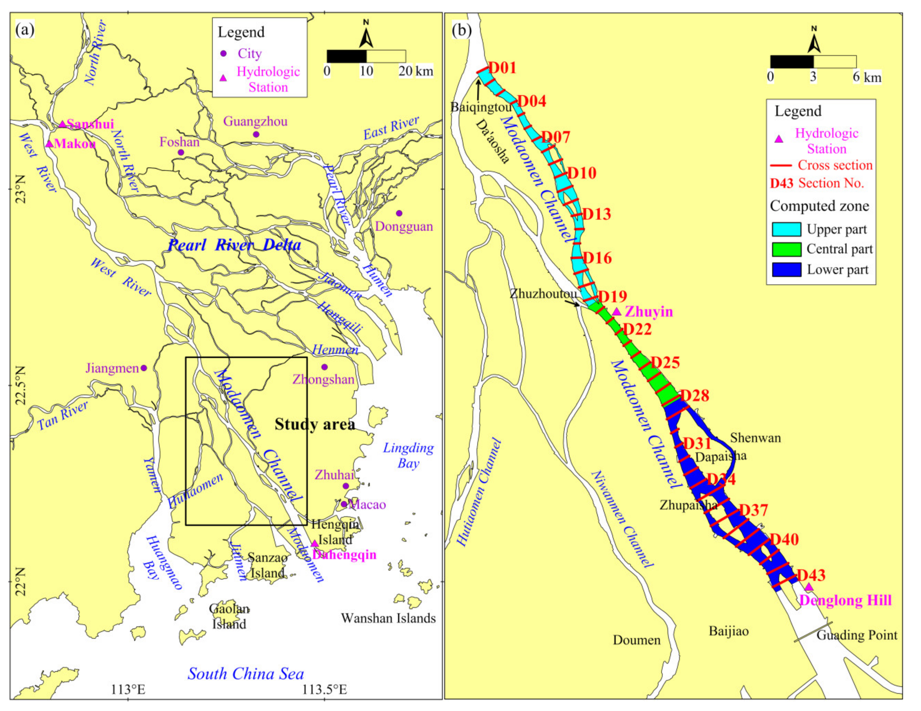
2. Study Area
3. Data and Methods
3.1. Data
3.2. Methods
4. Results
4.1. Planar Changes of the Channel
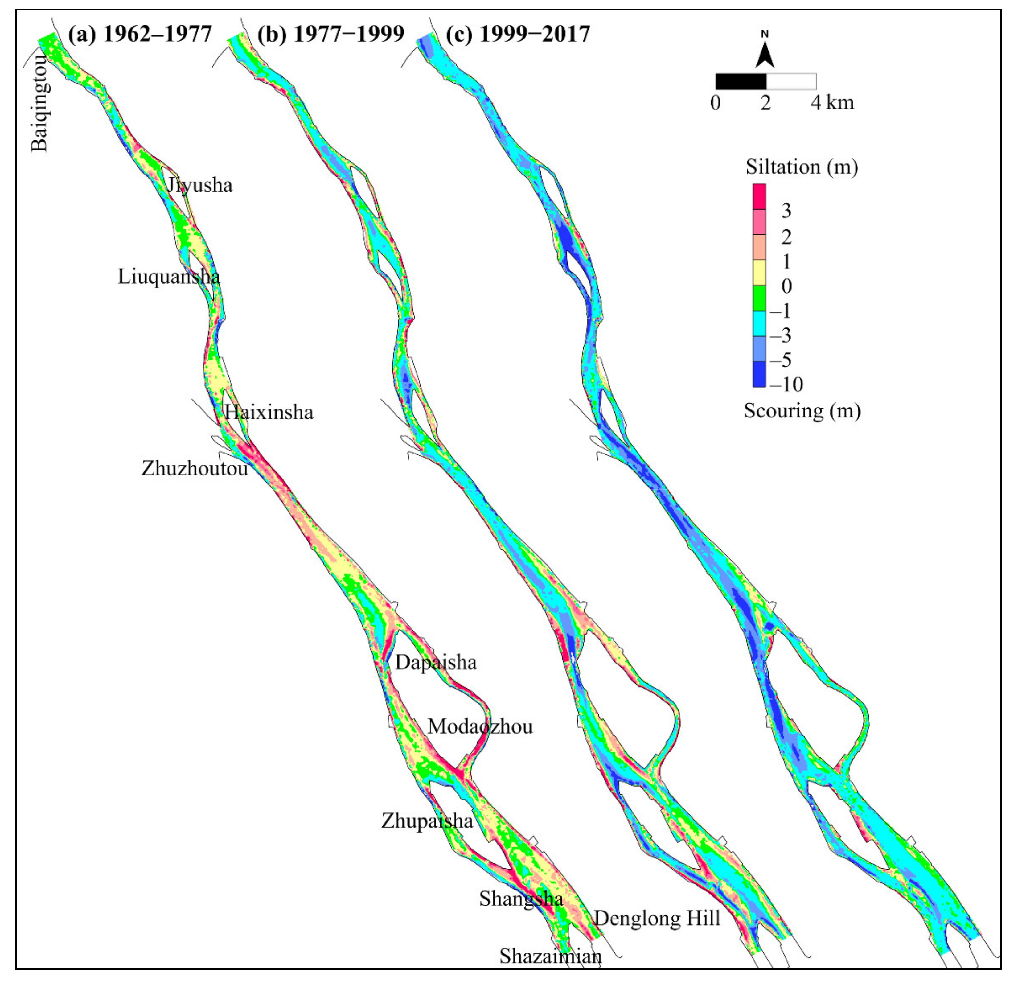
4.1.1. Planar Changes from 1962 to 1977
4.1.2. Planar Changes from 1977 to 1999
4.1.3. Planar Changes from 1999 to 2017
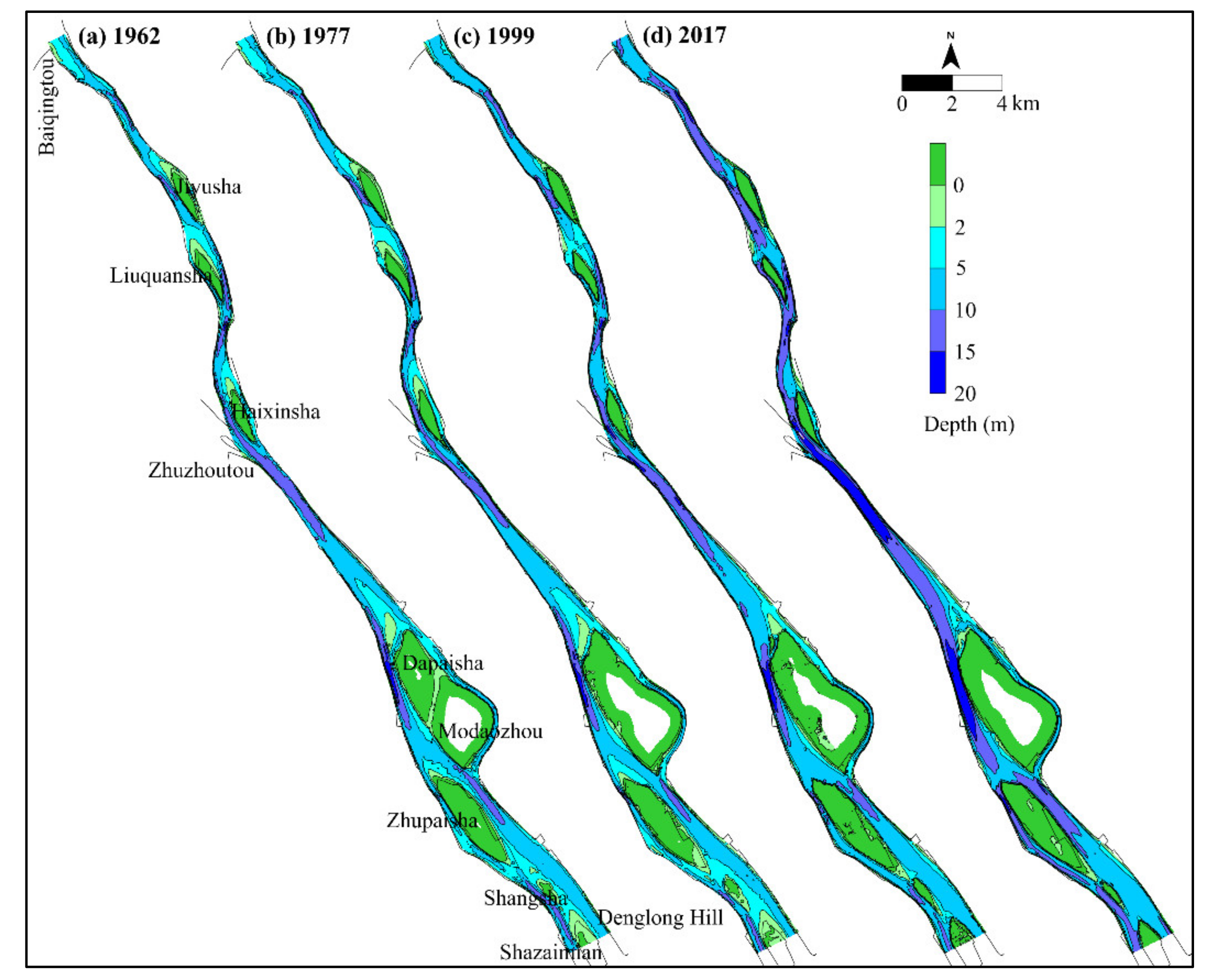
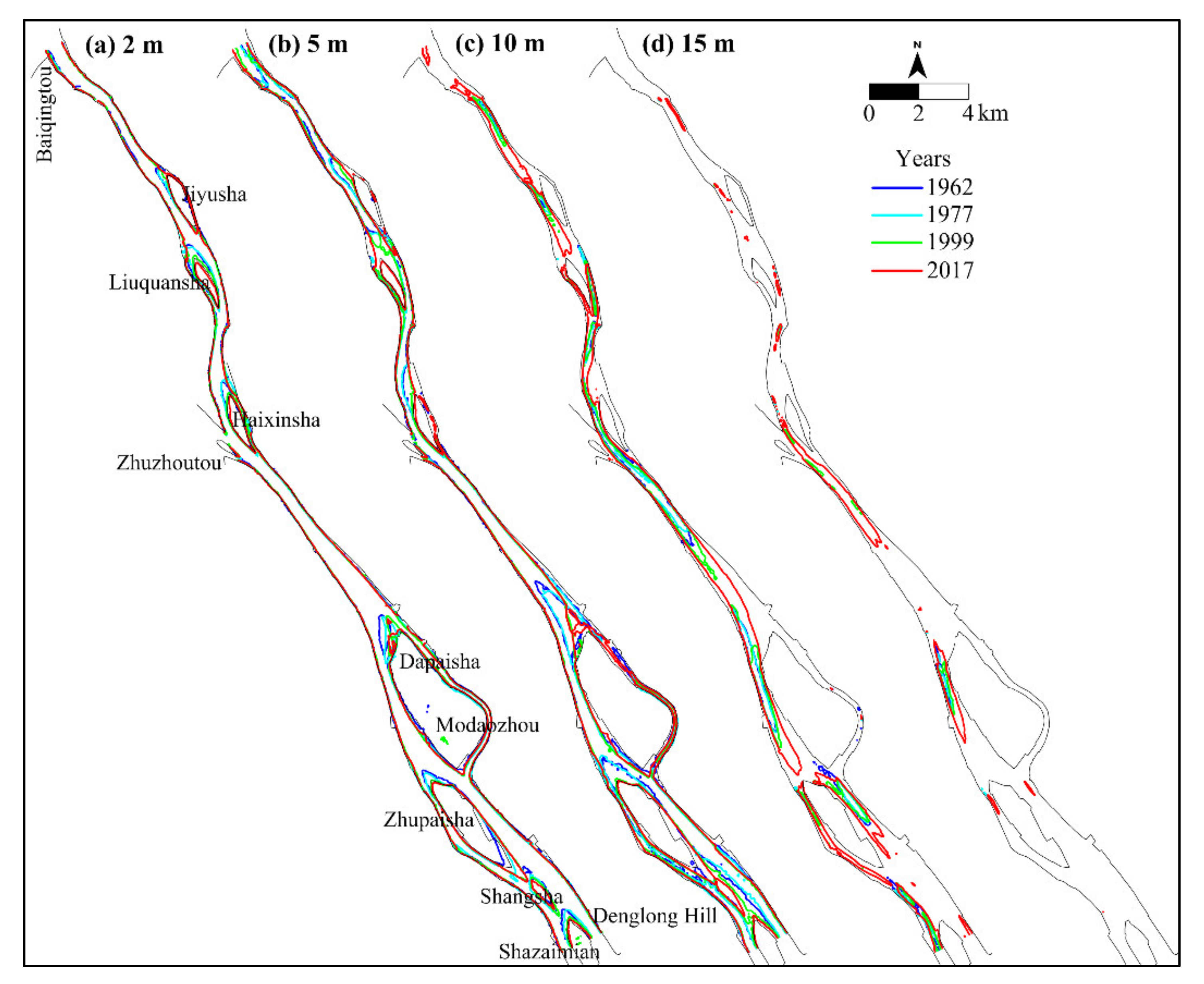
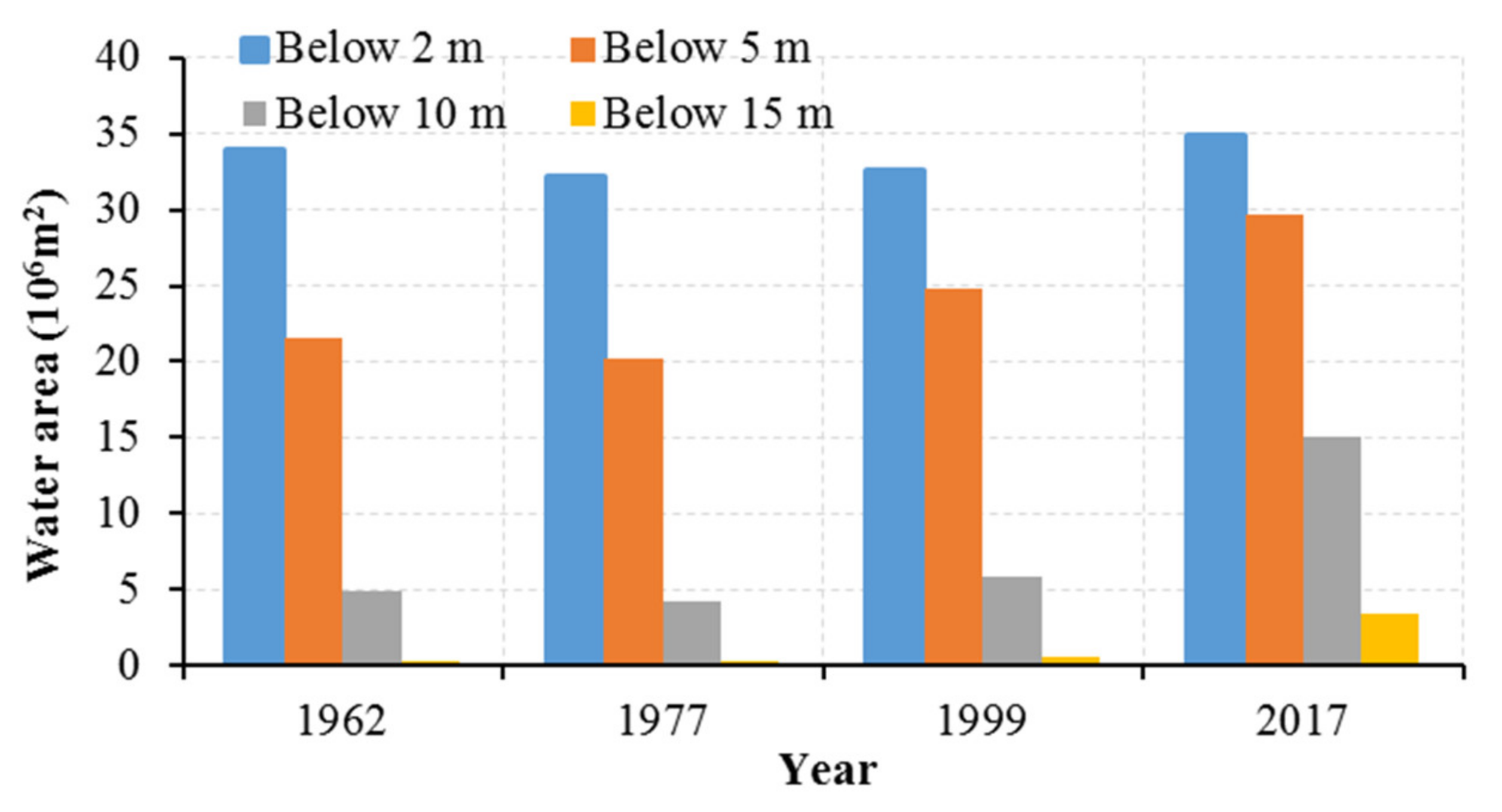
4.2. Changes in Water Depth and Volume
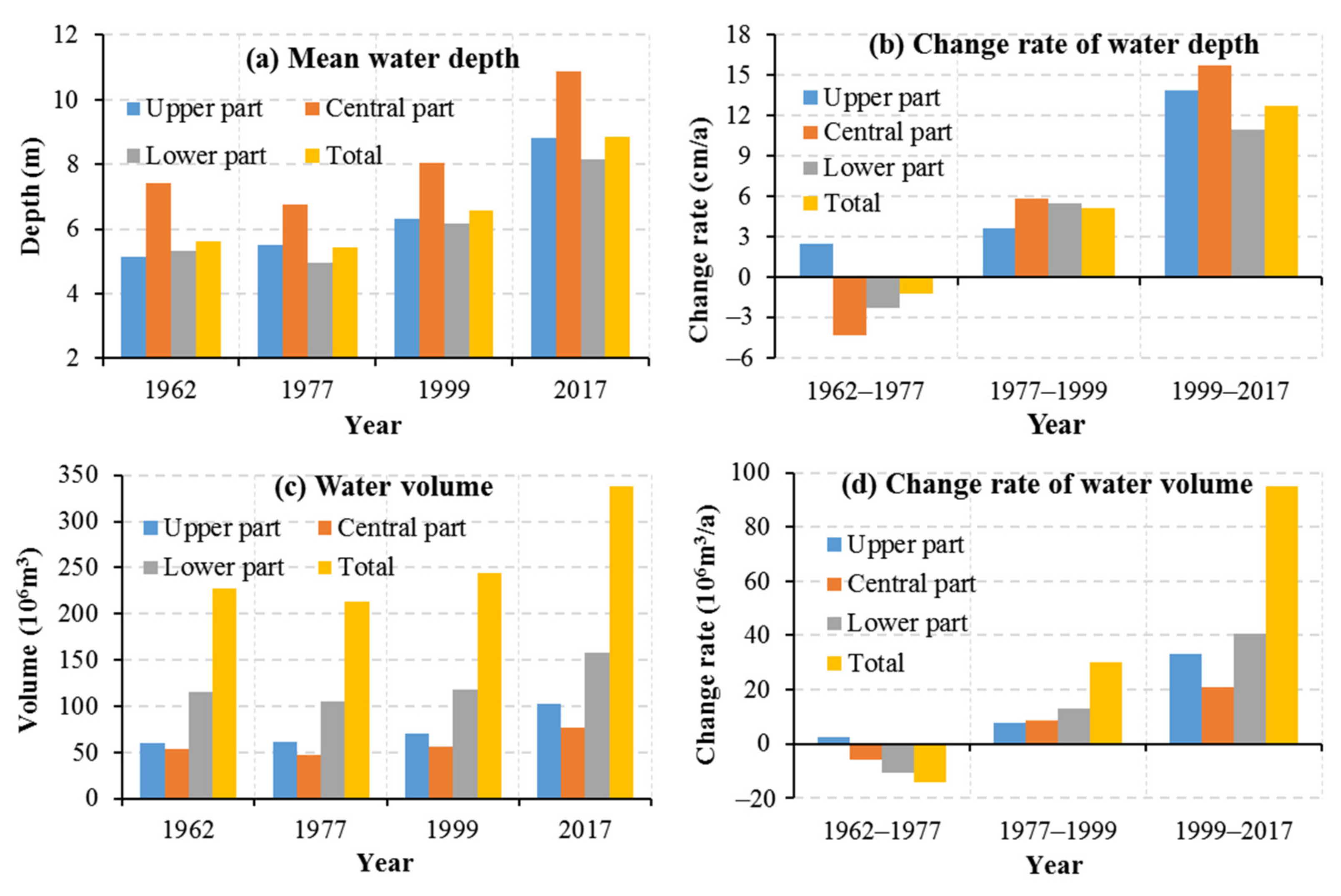
4.2.1. Changes in Water Depth
4.2.2. Changes in Water Volume
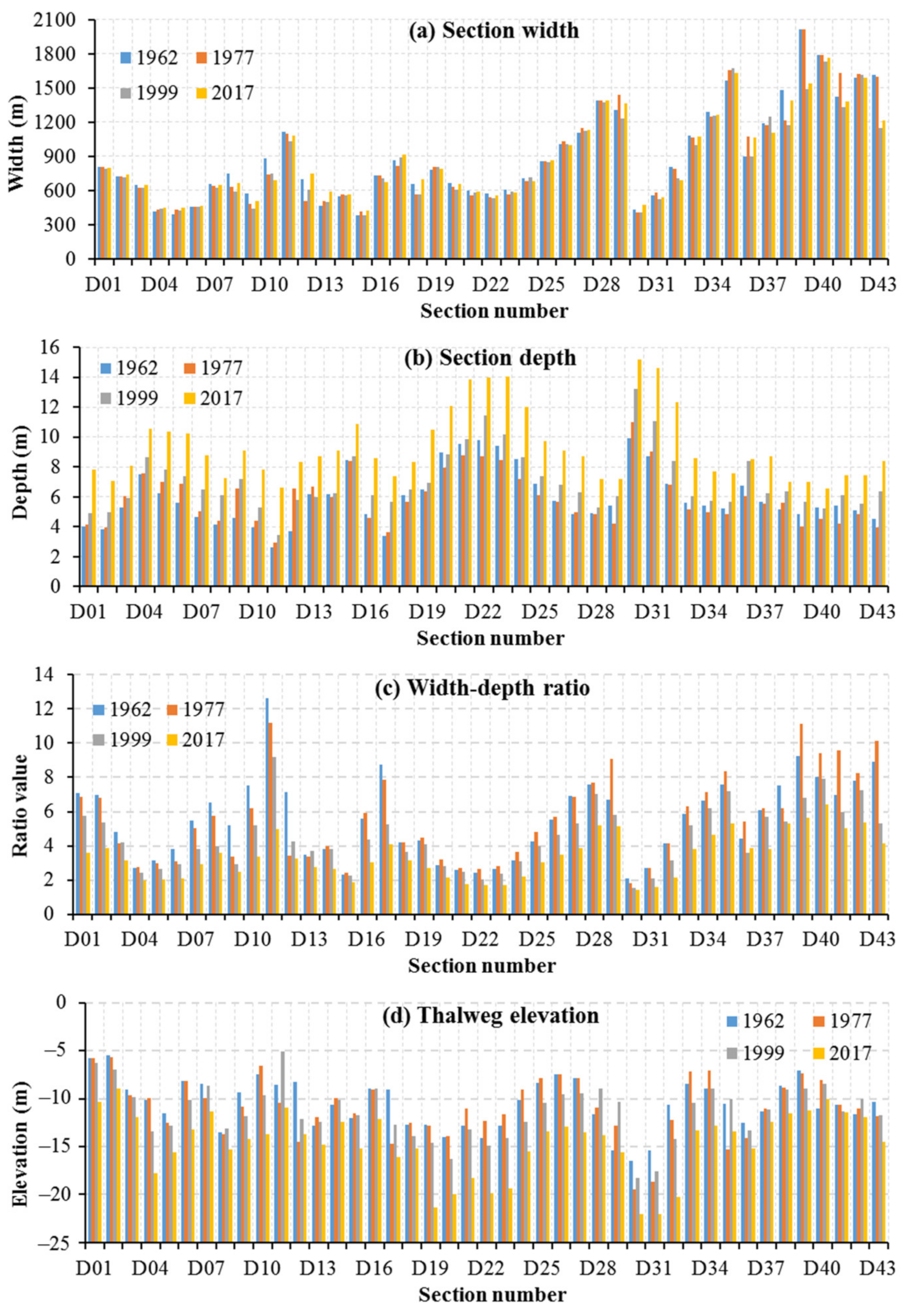
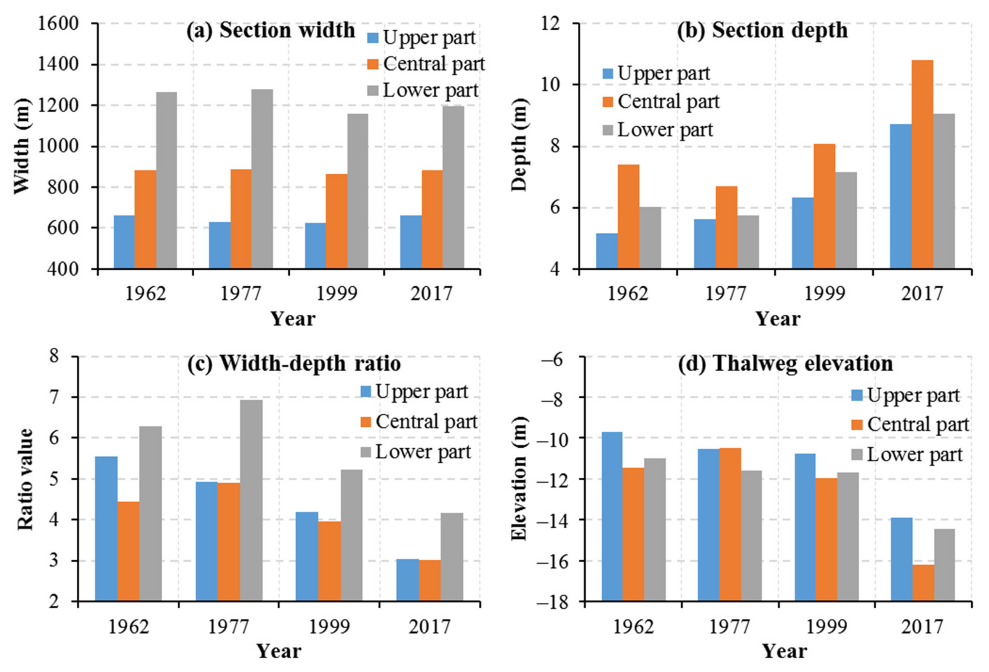
4.3. Changes in Cross-Sectional Shape
5. Discussion
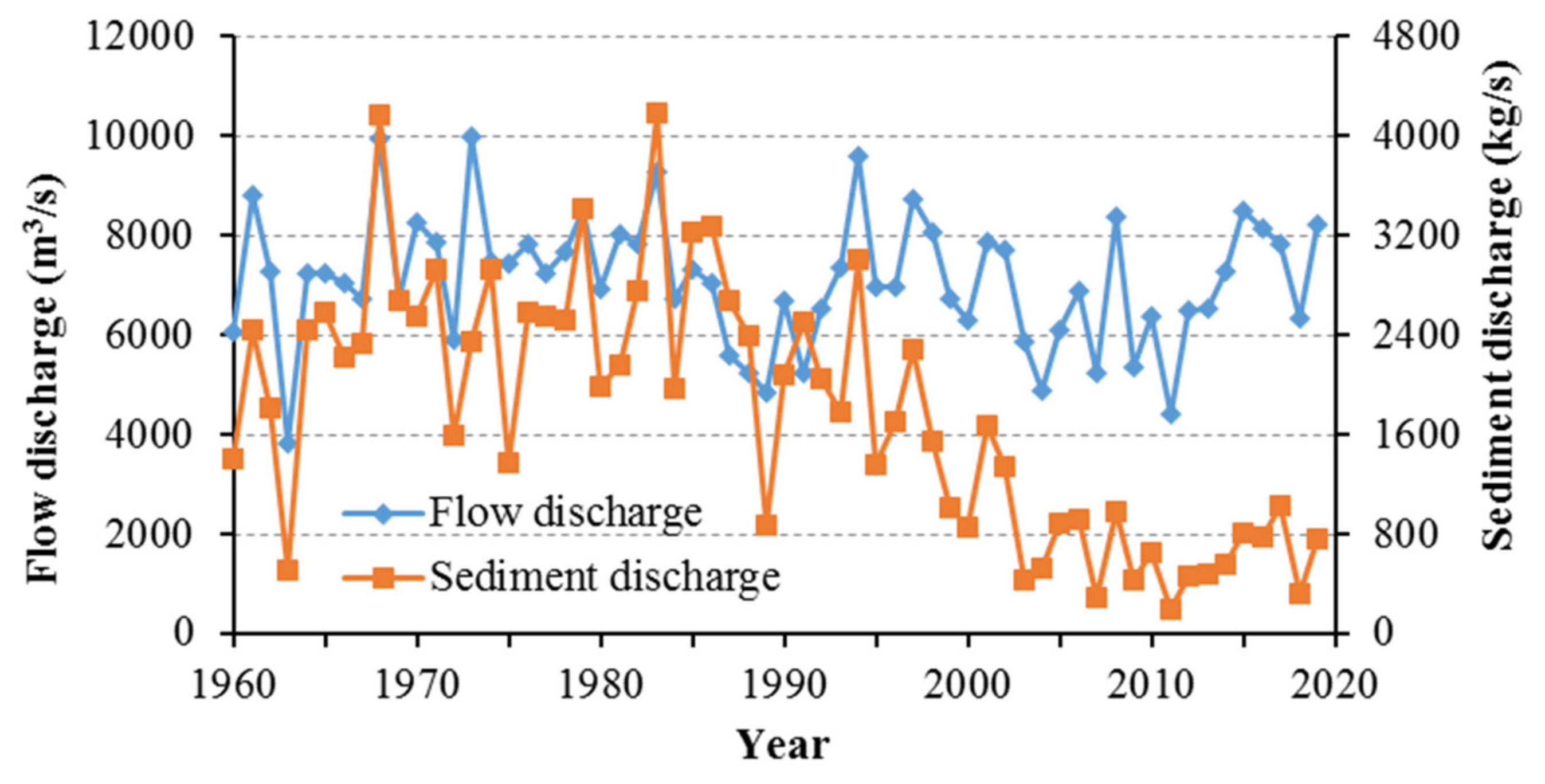
5.1. Impacts by River Flow and Sediment Discharge
5.2. Impact from Human Activities
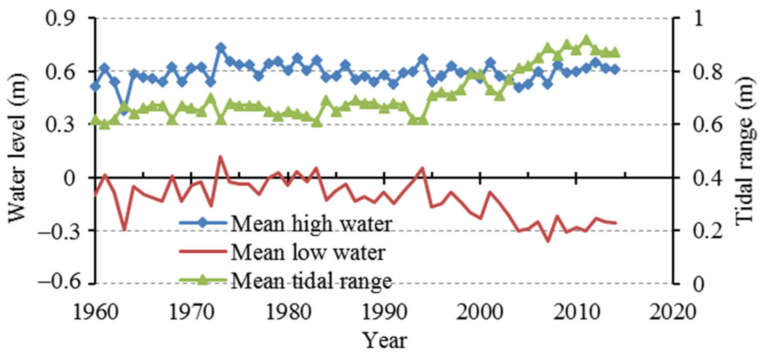
5.3. Impacts on Tidal Dynamics
5.4. Implications for Estuarine Management
6. Conclusions
Author Contributions
Funding
Institutional Review Board Statement
Informed Consent Statement
Data Availability Statement
Acknowledgments
Conflicts of Interest
References
- Guillen, J.; Palanque, A. A historical perspective of the morphological evolution in the lower Ebro River. Environ. Geol. 1997, 30, 174–180. [Google Scholar] [CrossRef]
- Giosan, L.; Syvitski, J.; Constantinescu, S.; Day, J. Protect the world’s deltas. Nature 2014, 516, 31–33. [Google Scholar] [CrossRef] [PubMed] [Green Version]
- Liu, F.; Yuan, L.R.; Yang, Q.S.; Ou, S.Y.; Xie, L.; Cui, X. Hydrological responses to the combined influence of diverse human activities in the Pearl River delta, China. Catena 2014, 113, 41–55. [Google Scholar] [CrossRef]
- Tan, C.; Huang, B.S.; Liu, F.; Huang, G.L.; Qiu, J.; Chen, H.; Liu, D.; Xie, R.Y. Recent morphological changes of the mouth bar in the Modaomen Estuary of the Pearl River Delta: Causes and environmental implications. Ocean Coast. Manag. 2019, 181, 104896. [Google Scholar] [CrossRef]
- Fanos, A.M. The impacts of human activities on the erosion and accretion of the Nile Delta coast. J. Coast. Res. 1995, 11, 821–833. [Google Scholar]
- Komar, P.D. Coastal erosion-underlying factors and human impacts. Shore Beach 2000, 68, 3–16. [Google Scholar]
- Dai, Z.J.; Liu, J.T.; Wei, W.; Chen, J.Y. Detection of the Three Gorges Dam influence on the Changjiang (Yangtze River) submerged delta. Sci. Rep. 2014, 4, 6600. [Google Scholar] [CrossRef]
- Fagherazzi, S.; Edmonds, D.A.; Nardin, W.; Leonardi, N.; Canestrelli, A.; Falcini, F.; Slingerland, R.L. Dynamics of river mouth deposits. Rev. Geophys. 2015, 53, 642–672. [Google Scholar] [CrossRef] [Green Version]
- Liu, F.; Xie, R.; Luo, X.X.; Yang, L.Z.; Cai, H.Y.; Yang, Q.S. Stepwise adjustment of deltaic channels in response to human interventions and its hydrological implications for sustainable water managements in the Pearl River Delta, China. J. Hydrol. 2019, 573, 194–206. [Google Scholar] [CrossRef]
- Han, Z.; Li, H.; Xie, H.; Yan, B.; Xie, M. Long-term geomorphological evolution of the mouth bar in the Modaomen Estuary of the Pearl River over the last 55 Years (1964–2019). Water 2022, 14, 90. [Google Scholar] [CrossRef]
- Han, Z.; Xie, H.; Li, H.; Xie, M. Morphological Evolution of the Lingding Channel in the Pearl River Estuary over the Last Decades. J. Coast. Res. 2020, 37, 104–112. [Google Scholar] [CrossRef]
- Chen, J.Y.; Chen, S.L. Estuarine and coastal challenge in China. Mar. Geol. Lett. 2002, 20, 174–181. (In Chinese) [Google Scholar]
- Allison, M.A. Geologic framework and environmental status of the Ganges-Brahmaputra delta. J. Coast. Res. 1998, 14, 826–836. [Google Scholar]
- Dai, Z.J.; Liu, J.T.; Wen, W. Morphological evolution of the South Passage in the Changjiang (Yangtze River) estuary, China. Quatern. Int. 2015, 380, 314–326. [Google Scholar] [CrossRef] [Green Version]
- Yang, S.L.; Zhang, J.; Zhu, J.; Smith, J.P.; Dai, S.B.; Gao, A.; Li, P. Impact of dams on Yangtze River sediment supply to the sea and delta inter-tidal wetland response. J. Geophys. Res. 2005, 110, F03006. [Google Scholar]
- Edmonds, D.A.; Slingerland, R.L. Mechanics of river mouth bar formation: Implications for the morphodynamics of delta distributary networks. J. Geophys. Res. 2007, 112, F02034. [Google Scholar] [CrossRef] [Green Version]
- Fan, H.; Huang, H.J.; Thomas, Q.Z. River mouth bar formation, riverbed aggradation and channel migration in the modern Huanghe (Yellow) River Delta, China. Geomorphology 2006, 74, 124–136. [Google Scholar] [CrossRef]
- Mei, X.F.; Dai, Z.J.; Wei, W.; Li, W.H.; Wang, J.; Sheng, H. Secular bathymetric variations of the North Channel in the Changjiang (Yangtze) Estuary, China, 1880–2013: Causes and effects. Geomorphology 2018, 303, 30–40. [Google Scholar] [CrossRef]
- Wei, W.; Dai, Z.J.; Mei, X.F.; Liu, J.P.; Gao, S.; Li, S.S. Shoal morphodynamics of the Changjiang (Yangtze) estuary: Influences from river damming, estuarine hydraulic engineering and reclamation projects. Mar. Geol. 2017, 386, 32–43. [Google Scholar] [CrossRef]
- Li, C.C.; Lei, Y.P.; He, W.; Dai, Z.J. Evolutional processes of the Pearl River Estuary and its protective regulation and exploitation. J. Sediment Res. 2002, 3, 44–51. (In Chinese) [Google Scholar]
- Han, Z.Y.; Tian, X.P.; Liu, F. Study on the causes of intensified saline water intrusion into Modaomen Estuary of the Zhujiang River in recent years. J. Mar. Sci. 2010, 28, 52–59. [Google Scholar]
- Jia, L.W.; Pan, S.Q.; Wu, C.Y. Effects of the anthropogenic activities on the morphological evolution of the Modaomen estuary, Pearl River Delta, China. China Ocean Eng. 2013, 27, 795–808. [Google Scholar] [CrossRef]
- Hu, D.L.; Liu, Q.H.; Wu, C.Y.; Yang, R.Q. Evolution of the Modaomen Channel of the Xijiang River based on DEM during the Last 40 Years. Geogr. Geo-Inf. Sci. 2009, 25, 55–58, 62. (In Chinese) [Google Scholar]
- Jiang, C.J.; Zhou, J.N.; Yang, Q.S. Effects of human intervention on tidal dynamics in the Modaomen Estuary, Pearl River. J. Trop. Oceanogr. 2020, 39, 66–76. (In Chinese) [Google Scholar]
- Milne, J.A.; Sear, D.A. Modelling River Channel Topography Using GIS. Int. J. Geogr. Inf. Sci. 1997, 11, 499–519. [Google Scholar] [CrossRef]
- Han, Z.Y.; Li, H.Y.; Xie, H.L.; Qiang, H.Y.; Pang, Q.X. Evolution of the river mouth bar in Liaohe Estuary with RS and GIS methods. Mar. Geol. Front. 2018, 34, 53–60. (In Chinese) [Google Scholar]
- Best, J. Anthropogenic stresses on the world’s big rivers. Nature Geosci. 2019, 12, 7–21. [Google Scholar] [CrossRef]
- Liu, F.; Hu, S.; Guo, X.J.; Cai, H.Y.; Yang, Q.S. Recent changes in the sediment regime of the Pearl River (South China): Causes and implications for the Pearl River Delta. Hydrol. Process. 2018, 32, 1771–1785. [Google Scholar] [CrossRef]
- Monge-Ganuzas, M.; Cearreta, A.; Evans, G. Morphodynamic consequences of dredging and dumping activities along the lower Oka estuary (Urdaibai Biosphere Reserve, southeastern Bay of Biscay, Spain). Ocean Coast. Manag. 2013, 77, 40–49. [Google Scholar] [CrossRef]
- Hoitink, A.J.F.; Jay, D.A. Tidal river dynamics: Implications for deltas. Rev. Geophys. 2016, 54, 240–272. [Google Scholar] [CrossRef]
- Luo, X.L.; Zeng, E.Y.; Ji, R.Y.; Wang, C.P. Effects of in-channel sand excavation on the hydrology of the Pearl River Delta, China. J. Hydrol. 2007, 343, 230–239. [Google Scholar] [CrossRef]
- Peng, X.Q.; Yuan, H.H. Innovating management system for strengthening the management of sand mining in the Pearl River Estuary. Pearl River Water Transp. 2012, 14, 47–49. (In Chinese) [Google Scholar]
- Yue, P.J. Evolution and development trend of Lingding Bay. J. Waterw. Harb. 2001, 22, 73–79, 90. (In Chinese) [Google Scholar]
- Hu, H.H.; Xu, Y.; Guan, M.K.; Jiang, Q.J. Analysis on morphological evolution of underwater delta in the Pearl River Estuary. J. Waterw. Harb. 2016, 37, 593–598. (In Chinese) [Google Scholar]
- Luo, X.X. Overview of shipping planning and implementation in the Pearl River Delta. Pearl River Water Transp. 2002, 4, 24–25. (In Chinese) [Google Scholar]


Publisher’s Note: MDPI stays neutral with regard to jurisdictional claims in published maps and institutional affiliations. |
© 2022 by the authors. Licensee MDPI, Basel, Switzerland. This article is an open access article distributed under the terms and conditions of the Creative Commons Attribution (CC BY) license (https://creativecommons.org/licenses/by/4.0/).
Share and Cite
Han, Z.; Li, H.; Xie, H.; Zuo, S.; Xu, T. Study of the Long-Term Morphological Evolution of the Modaomen Channel in the Pearl River Delta, China. Water 2022, 14, 1331. https://doi.org/10.3390/w14091331
Han Z, Li H, Xie H, Zuo S, Xu T. Study of the Long-Term Morphological Evolution of the Modaomen Channel in the Pearl River Delta, China. Water. 2022; 14(9):1331. https://doi.org/10.3390/w14091331
Chicago/Turabian StyleHan, Zhiyuan, Huaiyuan Li, Hualiang Xie, Shuhua Zuo, and Ting Xu. 2022. "Study of the Long-Term Morphological Evolution of the Modaomen Channel in the Pearl River Delta, China" Water 14, no. 9: 1331. https://doi.org/10.3390/w14091331
APA StyleHan, Z., Li, H., Xie, H., Zuo, S., & Xu, T. (2022). Study of the Long-Term Morphological Evolution of the Modaomen Channel in the Pearl River Delta, China. Water, 14(9), 1331. https://doi.org/10.3390/w14091331