Sedimentation and Erosion Patterns of the Lena River Anabranching Channel
Abstract
:1. Introduction
- To construct a set of regional empirical models between the surface sediment concentration and T, BI and ρ;
- Examine the variability in surface sediment distribution revealed by satellite images and total sediment budget by ADCP along the Lena anabranching channel;
- Provide a comparative study of the erosion and sedimentation patterns between various parts of the river system with a particular focus on the impacts of the thermal erosion processes on suspended sediment transport.
2. Study Area
3. Materials and Methods
3.1. Field Observations
3.2. Processing Satellite Images Data
3.3. Sedimentation Patterns Analyses
4. Results
4.1. Set of Regional Lena River Models for SSC Determination
4.2. Erosion and Sedimentation Patterns of the Lena River—From Pokrovsk to Aldan (Case Study 1)
4.3. Erosion and Sedimentation Patterns at the Lena River from Aldan to Zhigansk (Case Study 2)
4.4. Erosion and Sedimentation Patterns at the Lena River Delta (Case Study 3)
5. Discussion
5.1. Regional Empirical Models Validation
5.2. Drivers of Sediment Budget along the Lena River
6. Conclusions
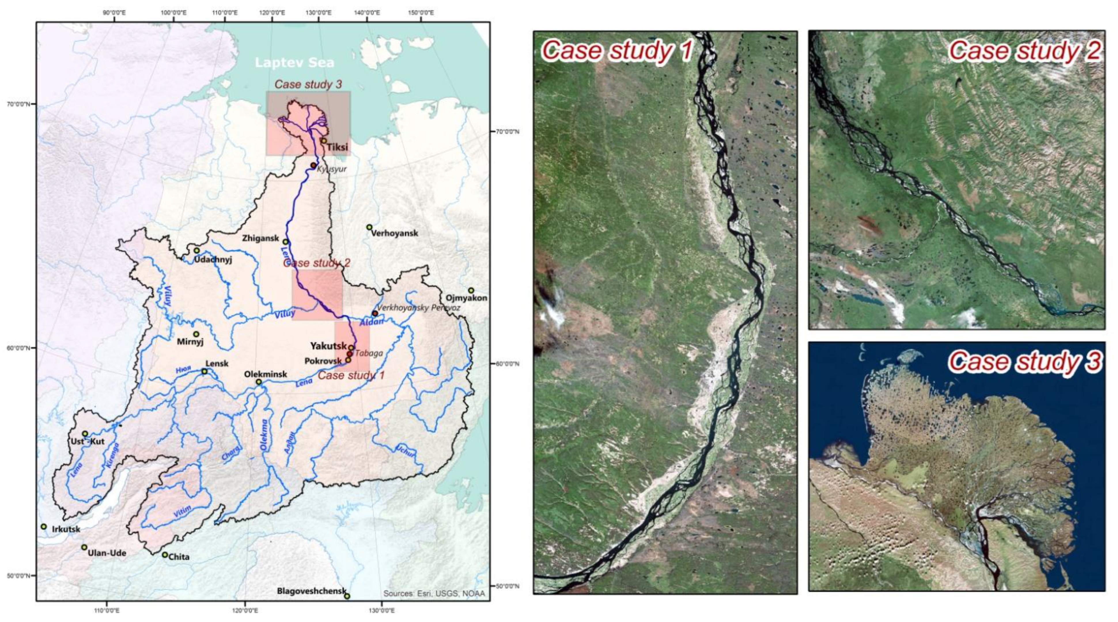
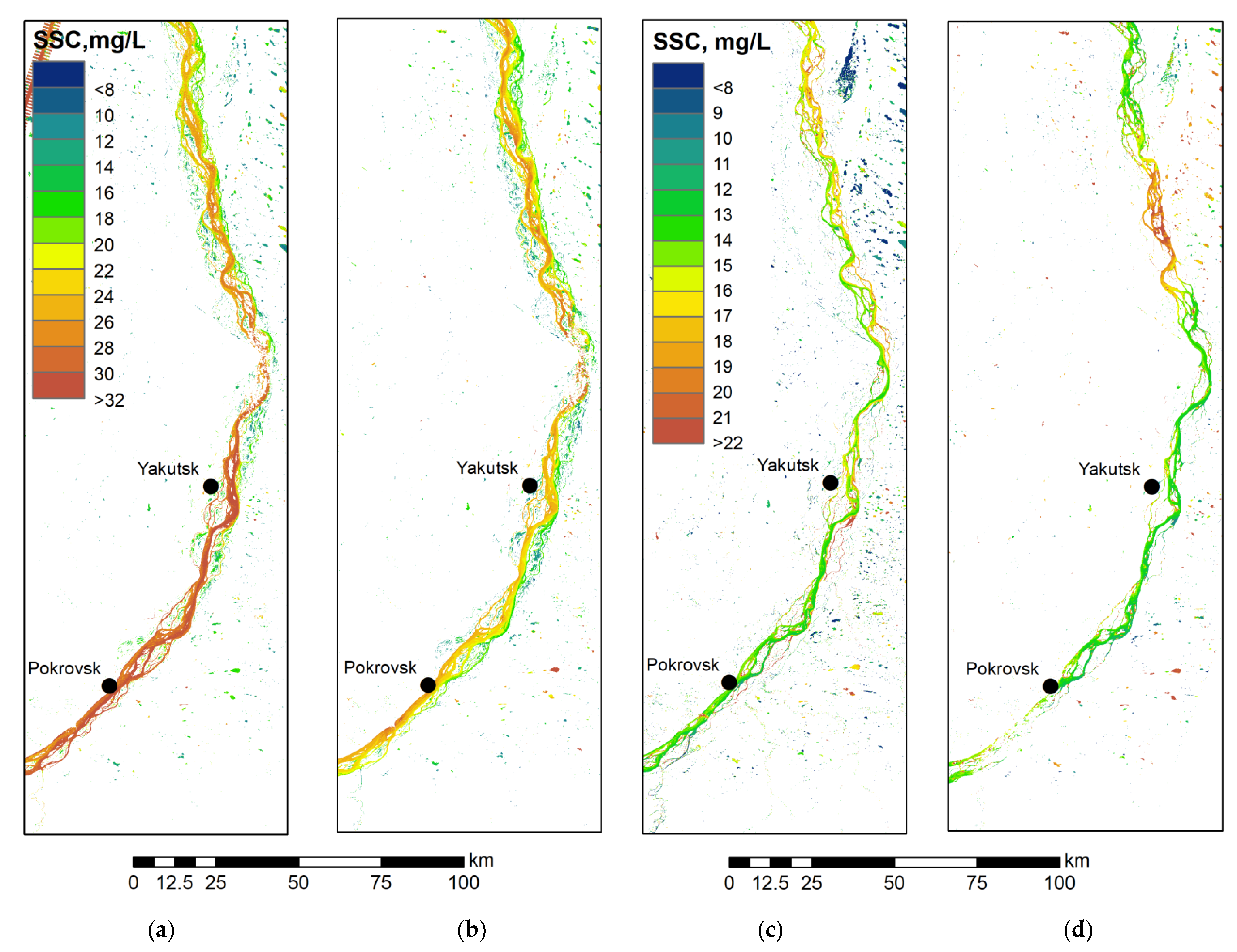
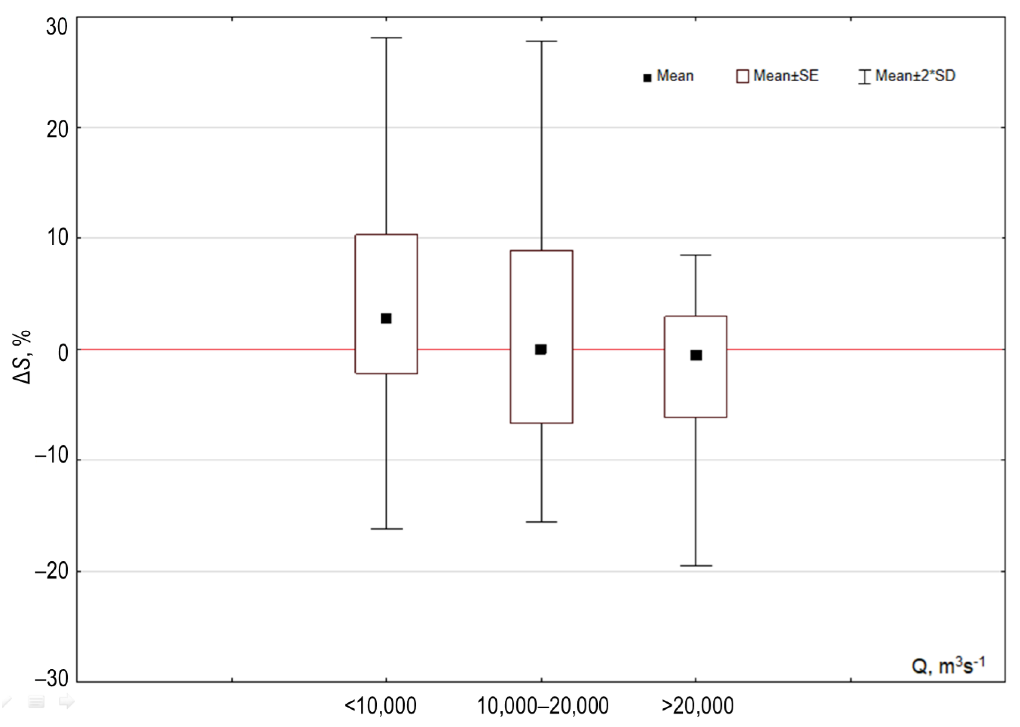
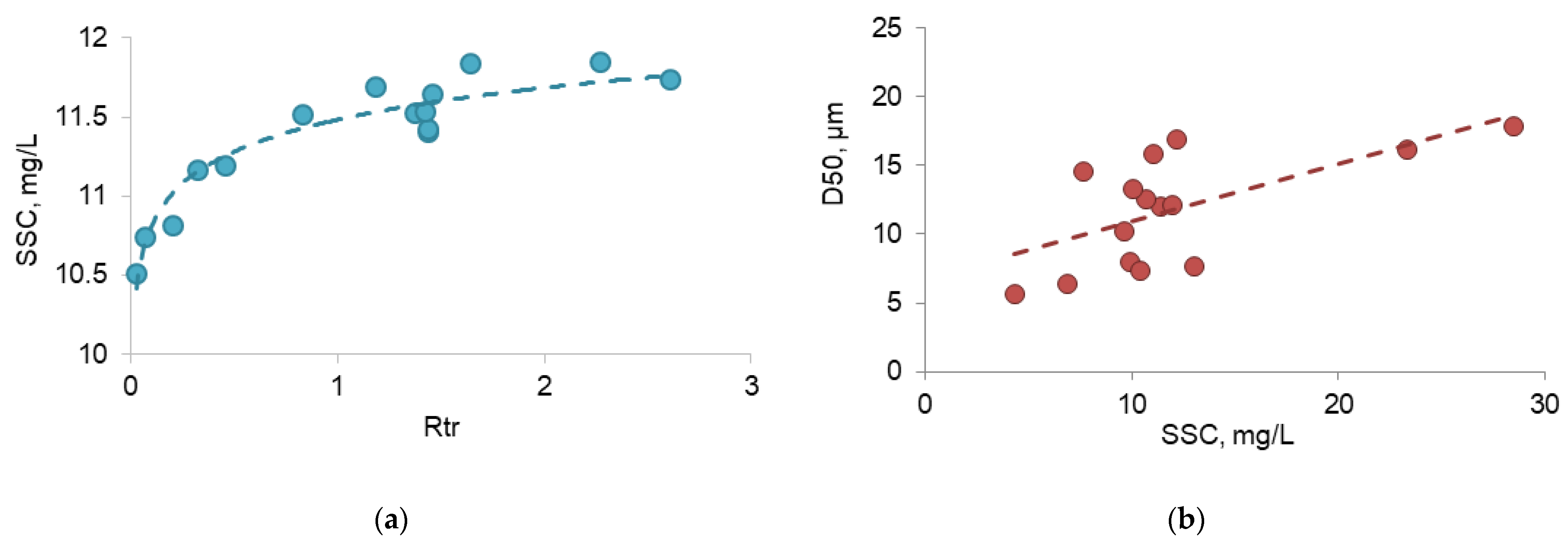
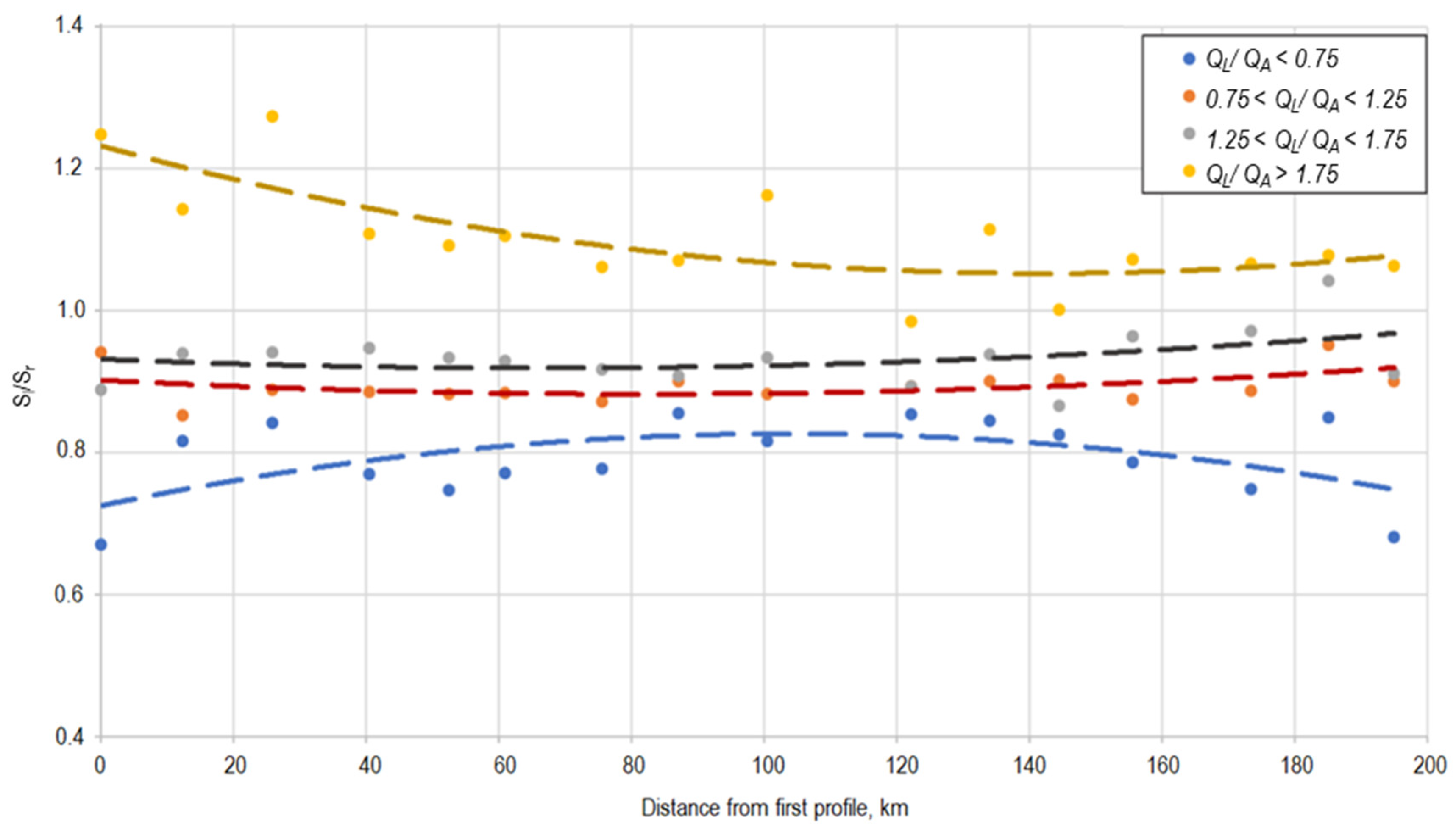
- In the middle reach (case study 1) the anabranching channel was characterized by seasonal effects in erosion and sedimentation. Over 50% of the suspended load is trapped under peak flow conditions. A 10–20% increase in the suspended load occurred during low-flow conditions due to impacts of thermal erosion. Sediment traps along the anabranching channel exist within secondary branches (100–200 m3s−1). Sediment concentration changes due to variability of stream flow parameters (velocity). We found a significant relationship between the velocity (transport capacity) and sediment concentration and conclude that hydrodynamic controls sediment sorting within anabranching reach.
- Anabranching channel reach which is influenced by the largest tributaries (Aldan and Viluy) (case study 2) is characterized by the sediment plumes which dominated spatial and temporal SSC distribution along the river section. A greater difference in water discharges between merging rivers is associated with higher sediment plumes along particular banks. Under these conditions, seasonal effects of sedimentation and erosion patterns cannot be detected.
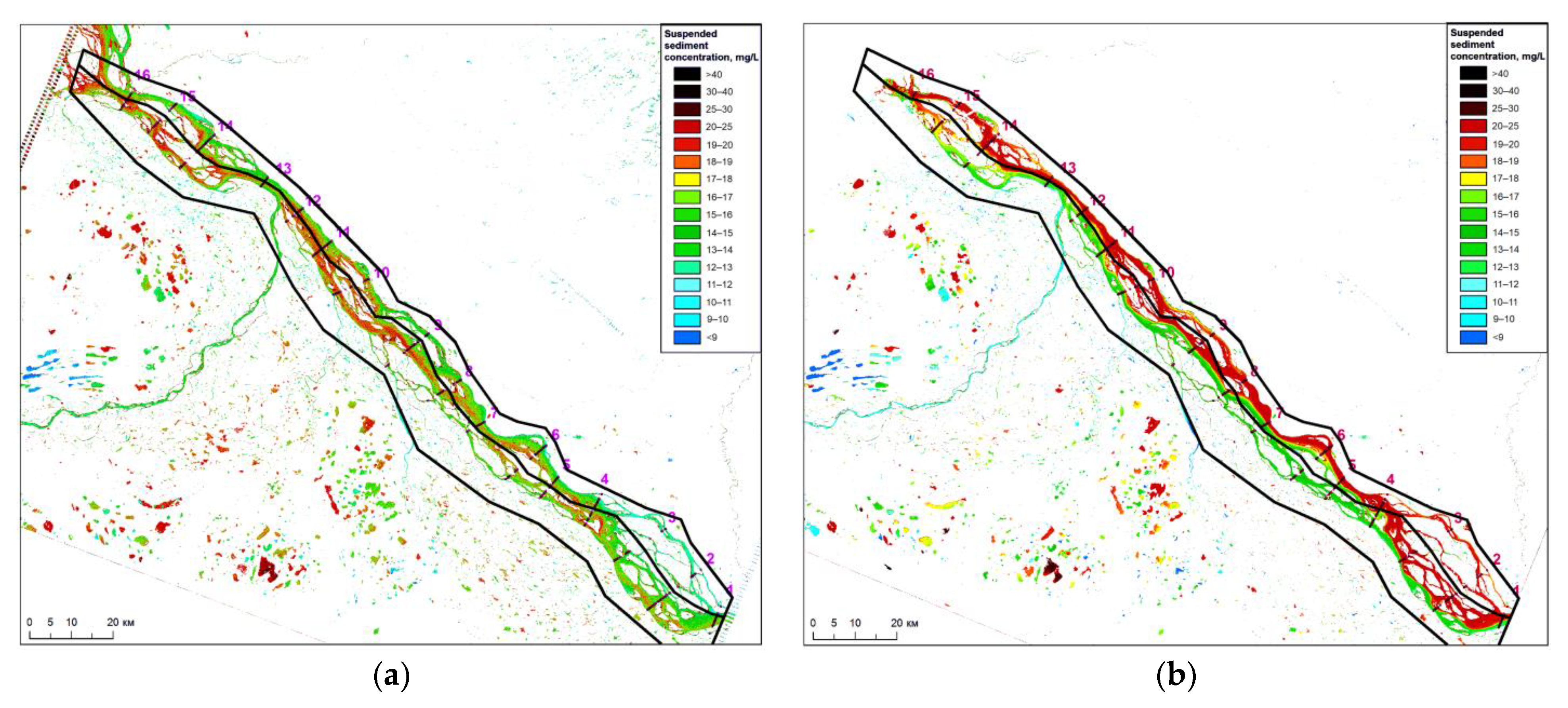
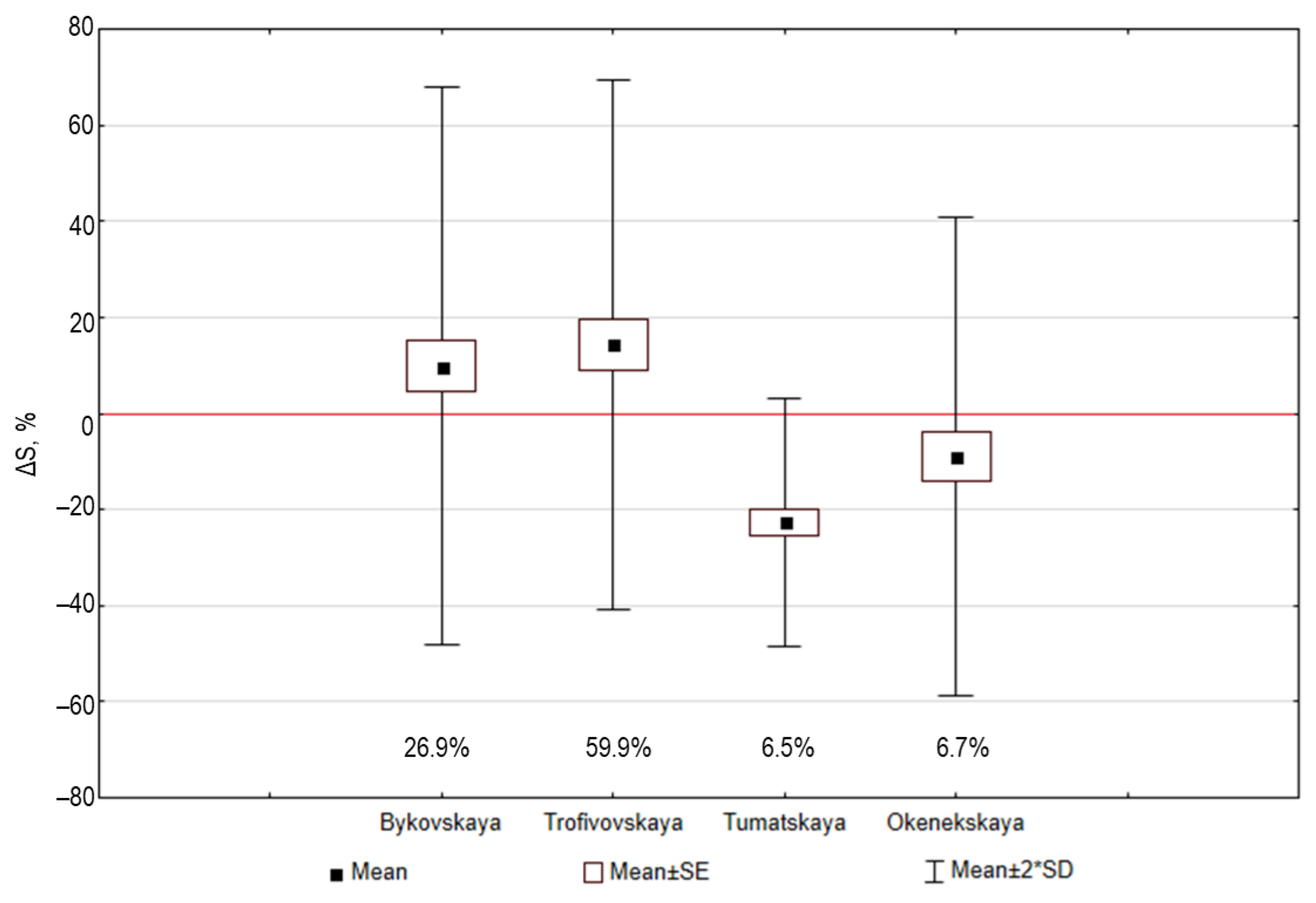
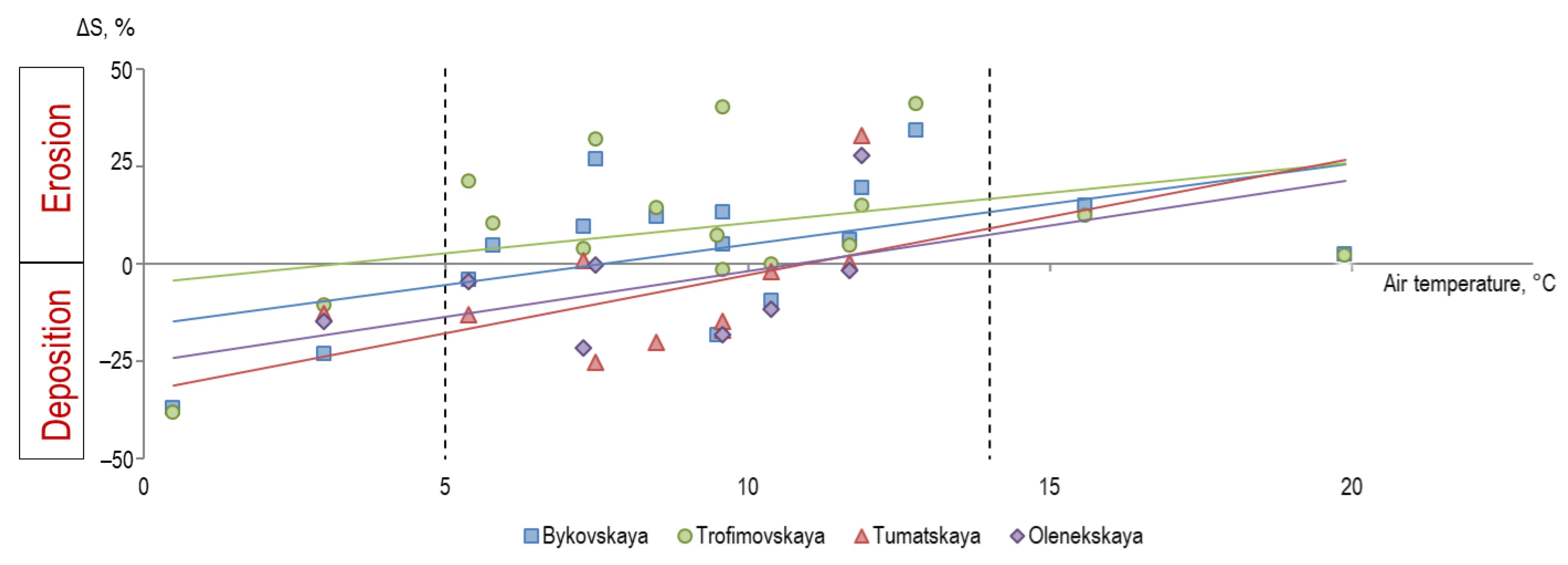
- The Lena delta (case study 3) demonstrates contrasting sediment patterns over its various parts. The observed changes in the suspended sediment transport in the delta are mostly related to channel erosion driven by thermal erosional processes. Here, the weather conditions during the summer affect the sediment budget along Yedoma banks which was reflected by the positive relationship observed between the daily air temperature and surface suspended sediment changes.
Author Contributions
Funding
Institutional Review Board Statement
Informed Consent Statement
Data Availability Statement
Acknowledgments
Conflicts of Interest
References
- Peterson, B.J.; Holmes, R.M.; McClelland, J.W.; Vörösmarty, C.J.; Lammers, R.B.; Shiklomanov, A.I.; Shiklomanov, I.A.; Rahmstorf, S. Increasing River Discharge to the Arctic Ocean. Science 2002, 298, 2171–2173. [Google Scholar] [CrossRef] [PubMed] [Green Version]
- Alexeevsky, N.I.; Chalov, R.S.; Berkovich, K.M.; Chalov, S.R. Channel changes in largest Russian rivers: Natural and anthropogenic effects. Int. J. River Basin Manag. 2013, 11, 175–191. [Google Scholar] [CrossRef]
- Chalov, S.R.; Liu, S.; Chalov, R.S.; Chalova, E.R.; Chernov, A.V.; Promakhova, E.V.; Berkovitch, K.M.; Chalova, A.S.; Zavadsky, A.S.; Mikhailova, N. Environmental and human impacts on sediment transport of the largest Asian rivers of Russia and China. Environ. Earth Sci. 2018, 77, 274. [Google Scholar] [CrossRef]
- Escoube, R.; Rouxel, O.J.; Pokrovsky, O.S.; Schroth, A.; Max Holmes, R.; Donard, O.F.X. Iron isotope systematics in Arctic rivers. Comptes Rendus Geosci. 2015, 347, 377–385. [Google Scholar] [CrossRef] [Green Version]
- Rachold, V.; Alabyan, A.M.; Hubberten, H.W.; Korotaev, V.N.; Zaitsev, A.A. Sediment transport to the Laptev Sea—Hydrology and geochemistry of the Lena River. Polar Res. 1996, 15, 183–196. [Google Scholar] [CrossRef] [Green Version]
- Pietroń, J.; Nittrouer, J.A.; Chalov, S.R.; Dong, T.Y.; Kasimov, N.; Shinkareva, G.; Jarsjö, J. Sedimentation patterns in the Selenga River delta under changing hydroclimatic conditions. Hydrol. Process. 2018, 32, 278–292. [Google Scholar] [CrossRef]
- Magritsky, D.V. Annual Sediment Yield of Russian Artctic Rivers and Its Anthropogenic Changes; Vestnik Moskovskogo Universiteta Series 5 Geography; Moskovskij Universitet: Moscow, Russia, 2010; pp. 17–24. (In Russian) [Google Scholar]
- Hasholt, B.; Bobrovitskaya, N.; Bogen, J.; McNamara, J.; Mernild, S.H.; Milburn, D.; Walling, D.E. Sediment transport to the Arctic Ocean and adjoining cold oceans. Hydrol. Res. 2006, 37, 413–432. [Google Scholar] [CrossRef]
- Syvitski, J.P.M.; Kettner, A. Sediment flux and the anthropocene. Philos. Trans. R. Soc. A Math. Phys. Eng. Sci. 2011, 369, 957–975. [Google Scholar] [CrossRef]
- Gautier, E.; Costard, F. Anastomosing-fluvial systems in the periglacial zone: The Lena River and its main tributaries (Central Siberia). Geogr. Phys. Quat. 2000, 54, 327–342. [Google Scholar]
- Golovlyov, P.; Kornilova, E.; Krylenko, I.; Belikov, V.; Zavadskii, A.; Fingert, E.; Borisova, N.; Morozova, E. Numerical modeling and forecast of channel changes on the river Lena near city Yakutsk. Proc. Int. Assoc. Hydrol. Sci. 2019, 381, 65–71. [Google Scholar] [CrossRef]
- Bolshiyanov, D.Y.; Makarov, A.S.; Schneider, V.; Stoof, G. Origin and Development of the Lena River Delta; AARI: St. Petersburg, Russia, 2013. (In Russian) [Google Scholar]
- Chalov, S.; Prokopeva, K.; Habel, M. North to South Variations in the Suspended Sediment Transport Budget within Large Siberian River Deltas Revealed by Remote Sensing Data. Remote Sens. 2021, 13, 4549. [Google Scholar] [CrossRef]
- Fedorova, I.; Chetverova, A.; Bolshiyanov, D.; Makarov, A.; Boike, J.; Heim, B.; Morgenstern, A.; Overduin, P.P.; Wegner, C.; Kashina, V.; et al. Lena Delta hydrology and geochemistry: Long-term hydrological data and recent field observations. Biogeosciences 2015, 12, 345–363. [Google Scholar] [CrossRef] [Green Version]
- Agafonova, S.A.; Frolova, N.A.; Surkova, G.V.; Koltermann, K.P. Modern characteristics of the ice regime of russian arctic rivers and their possible changes in the 21st centure. Geogr. Environ. Sustain. 2017, 10, 4–15. [Google Scholar] [CrossRef] [Green Version]
- Georgiadi, A.G.; Koronkevich, N.I.; Milyukova, I.P.; Barabanova, E.A. Integrated projection for runoff changes in large Russian river basins in the XXI century. Geogr. Environ. Sustain. 2016, 9, 38–46. [Google Scholar] [CrossRef] [PubMed] [Green Version]
- Lammers, R.B.; Shiklomanov, A.I.; Vörösmarty, C.J.; Fekete, B.M.; Peterson, B.J. Assessment of contemporary Arctic river runoff based on observational discharge records. J. Geophys. Res. Atmos. 2001, 106, 3321–3334. [Google Scholar] [CrossRef]
- Costard, F.; Gautier, E.; Brunstein, D.; Hammadi, J.; Fedorov, A.; Yang, D.; Dupeyrat, L. Impact of the global warming on the fluvial thermal erosion over the Lena River in Central Siberia. Geophys. Res. Lett. 2007, 34, L14501. [Google Scholar] [CrossRef]
- Gautier, E.; Dépret, T.; Cavero, J.; Costard, F.; Virmoux, C.; Fedorov, A.; Konstantinov, P.; Jammet, M.; Brunstein, D. Fifty-year dynamics of the Lena River islands (Russia): Spatio-temporal pattern of large periglacial anabranching river and influence of climate change. Sci. Total Environ. 2021, 783, 147020. [Google Scholar] [CrossRef] [PubMed]
- Tananaev, N.I. Hydrological and sedimentary controls over fluvial thermal erosion, the Lena River, central Yakutia. Geomorphology 2016, 253, 524–533. [Google Scholar] [CrossRef]
- Chalov, S.; Golosov, V.; Tsyplenkov, A.; Theuring, P.; Zakerinejad, R.; Märker, M.; Samokhin, M. A toolbox for sediment budget research in small catchments. Geogr. Environ. Sustain. 2017, 10, 43–68. [Google Scholar] [CrossRef] [Green Version]
- Chalov, S.R.; Bazilova, V.O.; Tarasov, M.K. Suspended sediment balance in Selenga delta at the late XX–early XXI century: Simulation by LANDSAT satellite images. Water Resour. 2017, 44, 463–470. [Google Scholar] [CrossRef]
- Pavelsky, T.M.; Smith, L.C. Remote sensing of suspended sediment concentration, flow velocity, and lake recharge in the Peace-Athabasca Delta, Canada. Water Resour. Res. 2009, 45, W11417. [Google Scholar] [CrossRef]
- Martinez, J.M.; Guyot, J.L.; Filizola, N.; Sondag, F. Increase in suspended sediment discharge of the Amazon River assessed by monitoring network and satellite data. Catena 2009, 79, 257–264. [Google Scholar] [CrossRef] [Green Version]
- Wang, J.; Lu, X.; Zhou, Y. Retrieval of suspended sediment concentrations in the turbid water of the Upper Yangtze River using Landsat ETM+. Chin. Sci. Bull. 2007, 52, 273–280. [Google Scholar] [CrossRef]
- Park, E.; Latrubesse, E.M. Modeling suspended sediment distribution patterns of the Amazon River using MODIS data. Remote Sens. Environ. 2014, 147, 232–242. [Google Scholar] [CrossRef]
- Park, E.; Latrubesse, E.M. A geomorphological assessment of wash-load sediment fluxes and floodplain sediment sinks along the lower Amazon River. Geology 2019, 47, 403–406. [Google Scholar] [CrossRef] [Green Version]
- Latrubesse, E.M.; Park, E.; Kastner, K. The Ayeyarwady River (Myanmar): Washload transport and its global role among rivers in the Anthropocene. PLoS ONE 2021, 16, e0251156. [Google Scholar] [CrossRef] [PubMed]
- Mertes, L.A.K.; Smith, M.O.; Adams, J.B. Estimating suspended sediment concentrations in surface waters of the Amazon River wetlands from Landsat images. Remote Sens. Environ. 1993, 43, 281–301. [Google Scholar] [CrossRef]
- Yang, D.; Kane, D.L.; Hinzman, L.D.; Zhang, X.; Zhang, T.; Ye, H. Siberian Lena River hydrologic regime and recent change. J. Geophys. Res. Atmos. 2002, 107, 4694. [Google Scholar] [CrossRef]
- Babin, M.; Stramski, D.; Ferrari, G.M.; Claustre, H.; Bricaud, A.; Obolensky, G.; Hoepffner, N. Variations in the light absorption coefficients of phytoplankton, nonalgal particles, and dissolved organic matter in coastal waters around Europe. J. Geophys. Res. Ocean. 2003, 108. [Google Scholar] [CrossRef]
- Strauss, J.; Laboor, S.; Schirrmeister, L.; Fedorov, A.N.; Fortier, D.; Froese, D.; Fuchs, M.; Günther, F.; Grigoriev, M.; Harden, J.; et al. Circum-Arctic Map of the Yedoma Permafrost Domain. Front. Earth Sci. 2021, 9, 758360. [Google Scholar] [CrossRef]
- Tananaev, N.I. Seasonal and long-term freezing of the cryolithozone river beds and its influence on channel changes (on the example of average Lena). Eros. Fluv. Process. Hydroecol. Probl. 2004, 195–201. (In Russian) [Google Scholar]
- Chalov, R.S. Fluvial Processes: Theory and Applications; Springer International Publishing: Cham, Switzerland, 2021; ISBN 978-3-030-66182-3. [Google Scholar]
- Schwamborn, G.; Rachold, V.; Grigoriev, M.N. Late Quaternary sedimentation history of the Lena Delta. Quat. Int. 2002, 89, 119–134. [Google Scholar] [CrossRef]
- Latrubesse, E.M. Patterns of anabranching channels: The ultimate end-member adjustment of mega rivers. Geomorphology 2008, 101, 130–145. [Google Scholar] [CrossRef]
- Ivanov, V.V.; Piskun, A.A.; Korabel, R.A. Distribution of Runoff through the Main Channels of the Lena River Delta. Proc. AARI 1983, 378, 59–71. (In Russian) [Google Scholar]
- Chalov, S.; Moreido, V.; Ivanov, V.; Chalova, A. Assessing suspended sediment fluxes with acoustic Doppler current profilers: Case study from large rivers in Russia. Big Earth Data 2022, 1–23. [Google Scholar] [CrossRef]
- Dominguez Ruben, L.G.; Szupiany, R.N.; Latosinski, F.G.; López Weibel, C.; Wood, M.; Boldt, J. Acoustic Sediment Estimation Toolbox (ASET): A software package for calibrating and processing TRDI ADCP data to compute suspended-sediment transport in sandy rivers. Comput. Geosci. 2020, 140, 104499. [Google Scholar] [CrossRef]
- Carlson, P.R.; Conomos, T.J.; Janda, R.J.; Peterson, D.H. Principal Sources and Dispersal Patterns-of Suspended Particulate Matter in Nearshore Surface Waters of the Northeast Pacific Ocean; Final Report; EROS Center: Sioux Falls, SD, USA, 1974. [Google Scholar]
- Curran, P.J.; Novo, E.M.M. The relationship between suspended sediment concentration and remotely sensed spectral radiance. Rev. J. Coast. Res. 1988, 361–368. [Google Scholar]
- Wackerman, C.; Hayden, A.; Jonik, J. Deriving spatial and temporal context for point measurements of suspended-sediment concentration using remote-sensing imagery in the Mekong Delta. Cont. Shelf Res. 2017, 147, 231–245. [Google Scholar] [CrossRef]
- Novo, E.M.M.; Hansom, J.D.; Curran, P.J. The effect of sediment type on the relationship between reflectance and suspended sediment concentration. Int. J. Remote Sens. 1989, 10, 1283–1289. [Google Scholar] [CrossRef] [Green Version]
- Chavez, P.S. Image-Based Atmospheric Corrections—Revisited and Improved. Photogramm. Eng. Remote Sens. 1996, 62, 1025–1036. [Google Scholar]
- Chavez, P.S. Radiometric calibration of Landsat Thematic Mapper multispectral images. Photogramm. Eng. Remote Sens. 1989, 55, 1285–1294. [Google Scholar]
- Chander, G.; Markham, B.L.; Helder, D.L. Summary of current radiometric calibration coefficients for Landsat MSS, TM, ETM+, and EO-1 ALI sensors. Remote Sens. Environ. 2009, 113, 893–903. [Google Scholar] [CrossRef]
- Chavez, P.S. An improved dark-object subtraction technique for atmospheric scattering correction of multispectral data. Remote Sens. Environ. 1988, 24, 459–479. [Google Scholar] [CrossRef]
- Sokolov, D.I.; Erina, O.N.; Tereshina, M.A.; Puklakov, V.V. Impact of Mozhaysk Dam on the Moscow River Sediment Transport. Geogr. Environ. Sustain. 2020, 13, 24–31. [Google Scholar] [CrossRef]
- Ankcorn, P.D. Clarifying Turbidity—The Potential and Limitations of Turbidity as a Surrogate for Water-Quality Monitoring. In Proceedings of the 2003 Georgia Water Resources Conference, Tifton, GA, USA, 23–24 April 2003. [Google Scholar]
- Belozerova, E.V.; Chalov, S.R. Assessment of River Water Turbidity Using the Optic Methods; Vestnik Moskovskogo Universiteta Seriya 5 Geografiya; Moskovskij Universitet: Moscow, Russia, 2013; pp. 39–45. (In Russian) [Google Scholar]
- Szupiany, R.N.; Lopez Weibel, C.; Guerrero, M.; Latosinski, F.; Wood, M.; Dominguez Ruben, L.; Oberg, K. Estimating sand concentrations using ADCP-based acoustic inversion in a large fluvial system characterized by bi-modal suspended-sediment distributions. Earth Surf. Process. Landf. 2019, 44, 1295–1308. [Google Scholar] [CrossRef]
- Choubey, V.K. Laboratory experiment, field and remotely sensed data analysis for the assessment of suspended solids concentration and secchi depth of the reservoir surface water. Int. J. Remote Sens. 1998, 19, 3349–3360. [Google Scholar] [CrossRef]
- Van Binh, D.; Kantoush, S.; Sumi, T. Changes to long-term discharge and sediment loads in the Vietnamese Mekong Delta caused by upstream dams. Geomorphology 2020, 353, 107011. [Google Scholar] [CrossRef]
- Martynov, A.V. Influence Of The Large Flood on the Element Composition of Fluvisols in the Amur River Valley. Geogr. Environ. Sustain. 2020, 13, 52–64. [Google Scholar] [CrossRef]
- Wang, J.J.; Lu, X.X.; Liew, S.C.; Zhou, Y. Retrieval of suspended sediment concentrations in large turbid rivers using Landsat ETM+: An example from the Yangtze River, China. Earth Surf. Process. Landf. 2009, 34, 1082–1092. [Google Scholar] [CrossRef]
- Bonnet, M.P.; Barroux, G.; Martinez, J.M.; Seyler, F.; Moreira-Turcq, P.; Cochonneau, G.; Melack, J.M.; Boaventura, G.; Maurice-Bourgoin, L.; León, J.G.; et al. Floodplain hydrology in an Amazon floodplain lake (Lago Grande de Curuaí). J. Hydrol. 2008, 349, 18–30. [Google Scholar] [CrossRef] [Green Version]
- Chalov, S.R.; Alexeevsky, N.I. Braided rivers: Structure, types and hydrological effects. Hydrol. Res. 2015, 46, 258. [Google Scholar] [CrossRef]
- Vandenberghe, J. Climate forcing of fluvial system development: An evolution of ideas. Quat. Sci. Rev. 2003, 22, 2053–2060. [Google Scholar] [CrossRef]
- Gordeev, V.V.; Rachold, V.; Vlasova, I.E. Geochemical behaviour of major and trace elements in suspended particulate material of the Irtysh river, the main tributary of the Ob river, Siberia. Appl. Geochem. 2004, 19, 593–610. [Google Scholar] [CrossRef] [Green Version]
- Griffin, C.G.; Frey, K.E.; Rogan, J.; Holmes, R.M. Spatial and interannual variability of dissolved organic matter in the Kolyma River, East Siberia, observed using satellite imagery. J. Geophys. Res. 2011, 116, G03018. [Google Scholar] [CrossRef] [Green Version]
- McClelland, J.W.; Holmes, R.M.; Peterson, B.J.; Raymond, P.A.; Striegl, R.G.; Zhulidov, A.V.; Zimov, S.A.; Zimov, N.; Tank, S.E.; Spencer, R.G.M.; et al. Particulate organic carbon and nitrogen export from major Arctic rivers. Glob. Biogeochem. Cycles 2016, 30, 629–643. [Google Scholar] [CrossRef]


| Data Type | Case Study | Date of Sampling | Samples | Water Discharges Range, m3s−1 | D50, µm | ||
|---|---|---|---|---|---|---|---|
| Average | Max | Min | |||||
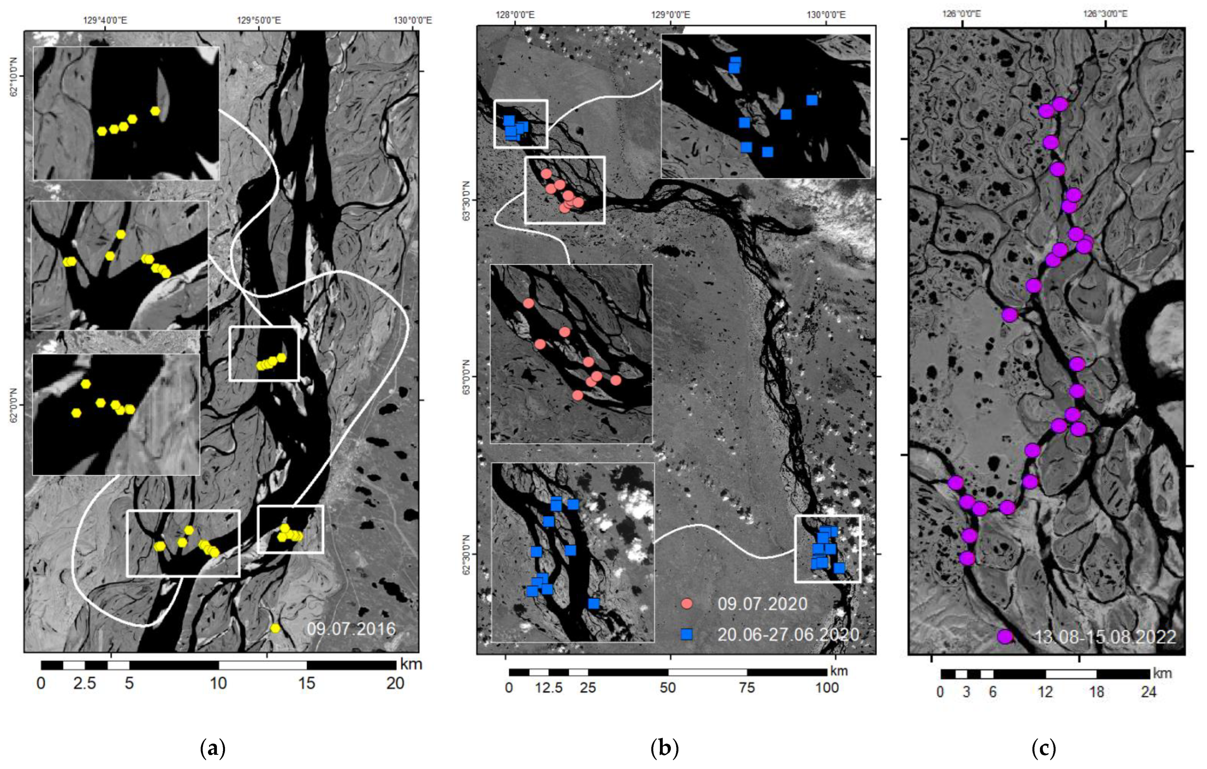
| Turbidity (NTU) | 1 | 20–29 June and 8–10 July 2016 | 82 | 12,200–26,400 (by Tabaga gauging station) | |||
| 1 | 25 June–10 July 2020 | 58 | 14,400–25,500 (by Tabaga gauging station) | 21.8 | 25.3 | 13.0 | |
| 2 | 27 June 2020 | 17 | 42,900 (authors measurement in Saham anabranching system) | 34.7 | 68.0 | 21.7 | |
| 2 | 3–5 July 2021 | 20 | 19,700 (authors measurement in Saham anabranching system) | 14.7 | 21.8 | 6.89 | |
| 1 | 20–23 September 2021 | 86 | 12,600 (authors measurement in Yakutsk anabranching system) | 11.3 | 16.3 | 6.33 | |
| 1 | 10–19 June 2022 | 38 | 20,200–25,200 (authors measurement in Yakutsk) | 25.6 | 64.6 | 16.7 | |
| 3 | 10–16 August 2022 | 22 | 31,300 (authors measurement in 4.7 km upper Stolb island) | 15.0 | 18.6 | 10.9 | |
| Surface water samples (SSC) | 1 | 20–28 June and 9 July 2016 | 39 | 12,400–26,400 (by Tabaga gauging station) | |||
| 2 | 7 July 2020 | 8 | 16,400 (by Tabaga gauging station) | 21.8 | 25.3 | 13.0 | |
| 3 | 13–15 August 2022 | 32 | 31,300 (authors measurement in 4.7 km upper Stolb island) | 14.7 | 17.1 | 11.0 | |
| ADCP | 1 | 25 June and 2 July 2020 | 8 | 20,300–25,500 (by Tabaga gauging station) | 21.8 | 25.3 | 13.0 |
| 1 | 23–25 September 2021 | 6 | 12,600 (authors measurement in Yakutsk anabranching system) | 11.3 | 16.3 | 6.33 | |
| 1 | 10–19 June 2022 | 12 | 20,200–25,200 (authors measurement in Yakutsk anabranching system) | 25.6 | 64.6 | 16.7 | |
| Parameter | Study Reach, Hydrological Season | Equation | R2 |
|---|---|---|---|
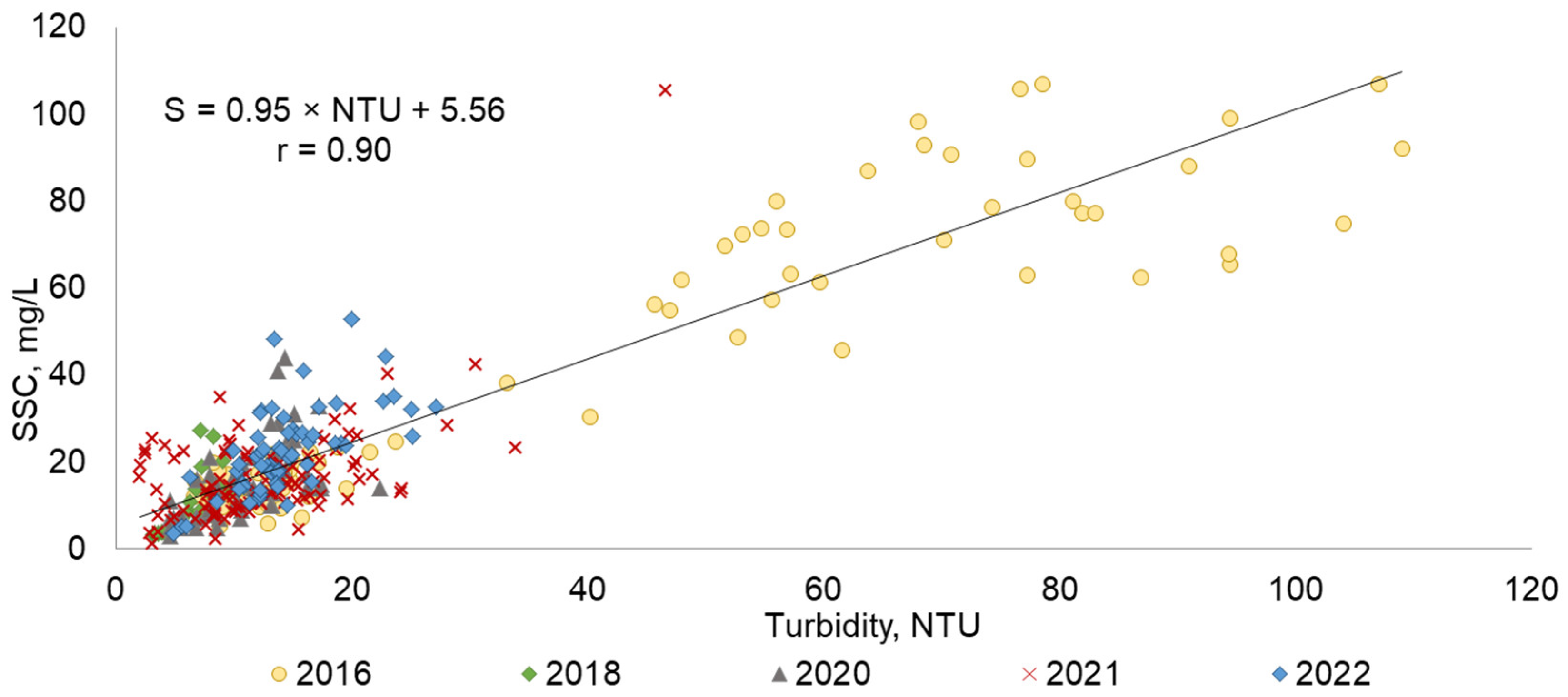
| Turbidity T, NTU | Case study 1, 2, 3 | SSC = 0.95T + 5.56 | 0.81 |
| Backscatter intensity BI, dB | Case study 1 | SSC = 0.59e0.382BI | 0.57 |
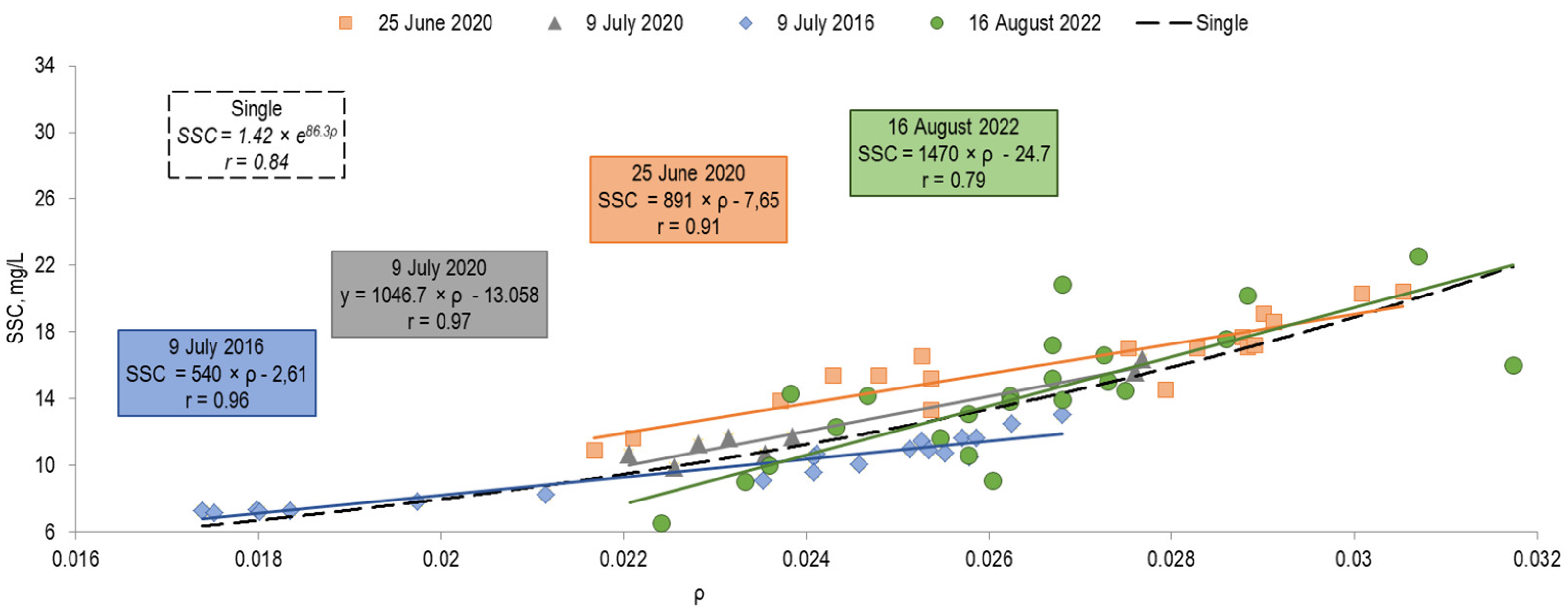
| Reflectance coefficient ρ (of the Landsat image in the red spectral band) | Case study 1, low water season | SSC = 540ρ − 2.61 | 0.91 |
| Case study 1,2 low water season | SSC = 1046ρ − 13.0 | 0.94 | |
| Case study 1, spring–summer flood water season | SSC = 891ρ − 7.65 | 0.82 | |
| Case study 3, low water season | SSC = 1470ρ − 24.7 | 0.62 | |
| Case study 1, 2, 3 | SSC = 1.42e86.3ρ | 0.66 |
| Path/Row | Acquisition Date | Date of Water Sampling | SSC, mg/L | |||||
|---|---|---|---|---|---|---|---|---|
| Samples (n) | Min | Max | Mean | Median | Std. Deviation | |||
| 121/017 | 9 July 2016 | 9 July 2016 | 21 | 7.16 | 13.0 | 9.79 | 10.5 | 1.89 |
| 122/016 | 25 June 2020 | 20 – 28 June 2016 | 18 | 10.9 | 20.5 | 16.2 | 16.8 | 2.68 |
| 124/015 | 9 July 2020 | 7 July 2020 2020/07/07 | 8 | 9.91 | 16.4 | 12.2 | 11.5 | 2.40 |
| 129/009 | 16 August 2022 | 13-15 August 2022 | 24 | 3.55 | 22.6 | 13.6 | 14.7 | 4.55 |
| Date of Water Sampling | Acquisition Date | SSC, mg/L | MAE, mg/L | MAPE, % | MSE | RMSE, mg/L | |
|---|---|---|---|---|---|---|---|
| Observed | Modeled | ||||||
| 20 July 2020 | 25 July 2020 | 14.6 | 16.6 | 2.0 | 13.7 | 3.37 | 1.83 |
| 20 July 2020 | 17.7 | 16.6 | 1.1 | 6.21 | |||
| 20 July 2020 | 19.1 | 16.9 | 2.2 | 11.5 | |||
| 20 July 2020 | 10.9 | 13.8 | 2.9 | 26.6 | |||
| 20 July 2020 | 17.1 | 16.8 | 0.3 | 1.75 | |||
| 20 July 2020 | 17 | 16.3 | 0.7 | 4.12 | |||
| 20 July 2020 | 17.2 | 17 | 0.2 | 1.16 | |||
| 20 July 2020 | 20.3 | 17.5 | 2.8 | 13.8 | |||
| 20 July 2020 | 20.4 | 17.6 | 2.8 | 13.7 | |||
| 20 July 2020 | 18.6 | 16.8 | 1.8 | 9.68 | |||
| 28 July 2020 | 13.4 | 15.5 | 2.1 | 15.7 | |||
| 28 July 2020 | 13.9 | 13.8 | 0.1 | 0.72 | |||
| 28 July 2020 | 11.7 | 14.7 | 3 | 25.6 | |||
| 28 July 2020 | 15.4 | 14.7 | 0.7 | 4.55 | |||
| 28 July 2020 | 17 | 16.1 | 0.9 | 5.29 | |||
| 28 July 2020 | 16.5 | 14.5 | 2.0 | 12.1 | |||
| 27 July 2020 | 15.4 | 14.7 | 0.7 | 4.55 | |||
| Mean | 1.55 | 10 | |||||
| Date of Water Sampling | Acquisition Date | SSC, mg/L | MAE, mg/L | MAPE, % | MSE | RMSE, mg/L | |
|---|---|---|---|---|---|---|---|
| Observed | Modeled | ||||||
| 9 July 2016 | 9 July 2016 | 10.7 | 11.5 | 0.80 | 7.48 | 3.86 | 1.96 |
| 9 July 2016 | 10.1 | 10.5 | 0.40 | 3.96 | |||
| 9 July 2016 | 9.1 | 9.4 | 0.30 | 3.30 | |||
| 9 July 2016 | 12.5 | 11.5 | 1.00 | 8.00 | |||
| 9 July 2016 | 10.7 | 10 | 0.70 | 6.54 | |||
| 9 July 2016 | 10.5 | 9.9 | 0.60 | 5.71 | |||
| 9 July 2016 | 11.5 | 11.2 | 0.30 | 2.61 | |||
| 9 July 2016 | 10.9 | 11.3 | 0.40 | 3.67 | |||
| 9 July 2016 | 11.0 | 11 | 0.00 | 0.00 | |||
| 9 July 2016 | 7.3 | 4.2 | 3.10 | 42.5 | |||
| 9 July 2016 | 7.3 | 5.1 | 2.20 | 30.1 | |||
| 9 July 2016 | 7.3 | 3.5 | 3.80 | 52.1 | |||
| 9 July 2016 | 7.2 | 3 | 4.20 | 58.3 | |||
| 9 July 2016 | 7.8 | 5.9 | 1.90 | 24.4 | |||
| 9 July 2016 | 8.3 | 6.9 | 1.40 | 16.9 | |||
| 9 July 2016 | 7.2 | 4.3 | 2.90 | 40.3 | |||
| 9 July 2016 | 13 | 12.3 | 0.70 | 5.38 | |||
| 9 July 2016 | 11.6 | 11.6 | 0.00 | 0.00 | |||
| 9 July 2016 | 11.6 | 11.8 | 0.20 | 1.72 | |||
| 9 July 2016 | 10.5 | 11.7 | 1.20 | 11.4 | |||
| 9 July 2016 | 9.6 | 9.9 | 0.30 | 3.13 | |||
| Mean | 1.26 | 15.6 | |||||
| Branch | % of The Total Discharge * | Average Channel Slope, m/km | ΔSmean | ΔSmax | ΔSmin | Numbers of Analyzed Situations | ||
|---|---|---|---|---|---|---|---|---|
| ΔS > 0 | ΔS < 0 | In Total | ||||||
| Bykovskaya (right) | 26.9 | 0.012 | 9.87 | 64.8 | −57.6 | 17 | 11 | 28 |
| Trofimovskaya (right) | 59.9 | 0.011 | 14.4 | 72.6 | −46.4 | 18 | 8 | 26 |
| Tumatskaya (left) | 6.5 | 0.009 | −22.7 | −2.65 | −46.4 | 0 | 23 | 23 |
| Olenekskaya (left) | 6.7 | 0.008 | −8.96 | 51.6 | −49.7 | 6 | 16 | 22 |
| Satellite Image Date | QL, m3s−1 | QA, m3s−1 | QL/QA | Discharge Ratio Group | Satellite Image Date | QL, m3s−1 | QA, m3s−1 | QL/QA | Discharge Ratio Group |
|---|---|---|---|---|---|---|---|---|---|
| 28 August 2009 | 17,700 | 5010 | 3.53 | 1 | 04 August 2006 | 6850 | 5760 | 1.19 | 3 |
| 30 August 2001 | 9500 | 4460 | 2.13 | 1 | 09 July 2014 | 11,700 | 10,400 | 1.13 | 3 |
| 30 September 2015 | 7620 | 3920 | 1.94 | 1 | 28 September 2000 | 9890 | 9180 | 1.08 | 3 |
| 03 September 2011 | 9590 | 5590 | 1.72 | 2 | 08 September 2007 | 8740 | 8220 | 1.06 | 3 |
| 12 June 2015 | 17,200 | 10,100 | 1.70 | 2 | 19 September 2011 | 10,800 | 10,300 | 1.05 | 3 |
| 02 August 2011 | 7880 | 4660 | 1.69 | 2 | 15 August 2016 | 12,900 | 13,100 | 0.98 | 3 |
| 14 June 2002 | 22,800 | 14,100 | 1,62 | 2 | 04 June 2013 | 20,700 | 22,000 | 0.94 | 3 |
| 01 August 2002 | 8770 | 5540 | 1.58 | 2 | 07 August 2013 | 22,800 | 26,000 | 0.88 | 3 |
| 12 June 2010 | 19,700 | 14,100 | 1.40 | 2 | 23 August 2013 | 15,900 | 18,400 | 0.86 | 3 |
| 12 June 2016 | 31,400 | 23,100 | 1.36 | 2 | 20 June 2013 | 18,200 | 21,600 | 0.84 | 3 |
| 10 September 1999 | 8650 | 6430 | 1.35 | 2 | 22 June 2013 | 14,100 | 18,800 | 0.75 | 4 |
| 08 June 2000 | 26,400 | 20,400 | 1.29 | 2 | 31 August 2016 | 9730 | 13,200 | 0.74 | 4 |
| 10 June 2000 | 14,100 | 21,100 | 0.67 | 4 |
Publisher’s Note: MDPI stays neutral with regard to jurisdictional claims in published maps and institutional affiliations. |
© 2022 by the authors. Licensee MDPI, Basel, Switzerland. This article is an open access article distributed under the terms and conditions of the Creative Commons Attribution (CC BY) license (https://creativecommons.org/licenses/by/4.0/).
Share and Cite
Chalov, S.; Prokopeva, K. Sedimentation and Erosion Patterns of the Lena River Anabranching Channel. Water 2022, 14, 3845. https://doi.org/10.3390/w14233845
Chalov S, Prokopeva K. Sedimentation and Erosion Patterns of the Lena River Anabranching Channel. Water. 2022; 14(23):3845. https://doi.org/10.3390/w14233845
Chicago/Turabian StyleChalov, Sergey, and Kristina Prokopeva. 2022. "Sedimentation and Erosion Patterns of the Lena River Anabranching Channel" Water 14, no. 23: 3845. https://doi.org/10.3390/w14233845
APA StyleChalov, S., & Prokopeva, K. (2022). Sedimentation and Erosion Patterns of the Lena River Anabranching Channel. Water, 14(23), 3845. https://doi.org/10.3390/w14233845


