Article

The Relationship between Suspended Solid Loads and Dissolved Material during Floods of Various Origin in Catchments of Different Use

Department of Environmental Research and Geo-Information, Institute of Geography and Environmental Sciences, Jan Kochanowski University, Uniwersytecka 7, 25-406 Kielce, Poland
*
Author to whom correspondence should be addressed.
Water 2023, 15(1), 90; https://doi.org/10.3390/w15010090
Submission received: 6 December 2022 / Revised: 22 December 2022 / Accepted: 24 December 2022 / Published: 27 December 2022
(This article belongs to the Special Issue Sediment Transport, Budgets and Quality in Riverine Environments)

Abstract

:
The paper presents the results of stationary, detailed studies on the variability of the mutual share of two fluvial loads, i.e., suspended solids and dissolved material during floods caused by rainstorm, continuous rainfalls and snowmelt in selected rivers (Silnica, Sufraganiec) draining small catchments in central Poland, including two characterized by a high level of urbanization. Irrespective of the origin of the flood, the share of suspended solids load did not exceed 80% in urbanized catchments, in suburban catchments—44%, and in forest catchments—32%. In the former, the gradient of the increase in the share of suspended solids and concentration time in the first phase of the flood was several times higher than in the other catchments. It was proved that statistically significant relationships exist between the share of sealed surfaces (roads, car parks, roofs, etc.) in the total catchment area and the average share of suspended solids, both in the rising and falling phase of the flood wave, regardless of their origin. Similar relationships were documented by analyzing: the density of the drainage network (storm sewers, roads, etc.)—the share of suspension. The obtained results have an interesting cognitive aspect and in practice are used for the development of hydrotechnical documentation related to water management in the city.

1. Introduction

Fluvial transport is characterized by constant changes in the proportion between the suspended solid loads and dissolved material. In the literature on fluvial geomorphology, many works compared the size of load of transported suspended solids and dissolved material in the areas of diverse land use types [1,2,3,4,5,6]. Many researchers believe that the internal structure of fluvial transport indicates the diversity of supply sources in the catchment and reflects contemporary geomorphic processes taking place in the riverbed and in the catchment area [7,8,9,10,11,12,13,14,15]. This phenomenon is particularly visible during floods, when the size of the transported loads of suspended solids and dissolved material varies in time and changes rapidly [2,4,10,16]. The nature of the use of the area and the manner of developing riverbeds condition and modify flood waves propagation as well as mechanisms and intensity of fluvial processes [17,18,19,20,21,22,23,24,25,26,27]. In recent decades, interest in the hydrology of urbanized areas has significantly increased due to design needs as well as the need to protect cities from floods and to improve the quality of water in watercourses [28,29,30,31,32,33,34,35,36,37,38]. Research regarding fluvial aspects in urban catchments, and above all, in the areas and sources supplying riverbeds as well as dynamics and the volume of fluvial transport was conducted in various countries around the world [39,40,41,42,43,44,45]. Rivers that drain small, urbanized catchments are characterized by the uneven hydrological regime, similarly to the mountain rivers which take most of their annual material load during floods [46,47,48,49]. There are only a few works devoted to fluvial transport in urban catchments during floods [39,43,50,51,52]. Difficulties in conducting research in the catchments of small rivers that drain urban areas, especially in the situation of growing pressure from urbanization, consist of, among others, the lack of accessibility to detailed hydrological and fluvial data. It especially concerns such series that would cover the period of research in the same catchment before the development of the city as well as during its expansion and functioning.
The question is whether urbanization, and in particular, the share of poorly permeable and impervious areas (roads, parking lots, roofs, etc.), density of drainage network (roads, storm channels, etc.), water reservoirs, adjustment of riverbeds and winter road maintenance, can significantly influence the shaping of the relationship between suspended solid loads and dissolved material during floods of diverse origin.
The aim of the present work is then to present the variability of mutual relations between the basic components of fluvial transport, i.e., loads of suspended solids and dissolved material during floods caused by rainstorms, continuous rainfalls and snowmelts, in urbanized catchments compared to forest and suburban catchments, located in the city of Kielce (Poland).

2. Materials and Methods

2.1. Study Area

The research concerned two small rivers flowing through the city of Kielce (200,000 inhabitants) (central Poland). The Silnica river flows through its center, and the Sufraganiec flows on the outskirts of the city. These rivers drain the neighboring catchments of a similar area (49.4 km2 and 62.0 km2), geological structure (Paleozoic structures) and relief (average slope of 50‰). The studied catchments, however, differ significantly in the use of the area, especially regarding the share of impervious surfaces (from 1.7% to 30.2%). Five (5) outlets were located in the Silnica catchment: Si1 (Dąbrowa)—forest sub-catchment, Si2 (Piaski)—suburban sub-catchment, Si3 (Jesionowa)—with water reservoir catchment, Si4 (Pakosz) and Si5 (Białogon)—urban sub-catchments; and three (3) in the catchment of the Sufraganiec: Su1 (Grzeszyn)—forest sub-catchment, Su2 (Niewachlów) and Su3 (Pietraszki)—suburban sub-catchments (Figure 1, Table 1).
In the upper part of the Silnica catchment, as far as the Si1 outlet, forests cover 72.9% of the overall catchment area (Table 1). In the lower sub-catchments: Si2, Si3 and Si4, the share of forests decreases and the surface of sealed areas increases (roads, hardened parking lots, buildings). These surfaces are poorly permeable and are characterized by very low retention [44,53]. Therefore, water flows easily down these surfaces, along with accumulated substances of natural and anthropogenic origin [54]. There is a retention reservoir (recreational) with an area of 10.5 ha and a capacity of 170 thousand m3 between the Si2 and Si3 outlets. It is not used for economic purposes (no collection of water and its discharges, no hydropower plant). The water level in the reservoir is regulated sporadically. The average annual suspended sediment load in this reservoir is approx. 23 Mg, and the load-bed—approx. 21 Mg. The result is a slowly growing delta at the rate of approx. 1 m per year, which did not cause a significant decrease in the volume of the reservoir during the study period. In the catchment, as far as the Si4 outlet, which is located below the center of Kielce, the share of sealed areas is 30.2%.
Below, as far as the Si5 outlet, the surface of forests and meadows increases slightly, and one of the sealed areas decreases to 27.6% [50]. The drainage system in the studied catchments was described by using density indicators: of road network, and covered and open canals (km·km−2). Their highest values occur in the urban part of the Silnica catchment (Si4), reaching 12.6 and 4.9 km·km−2, respectively. In the Sufraganiec catchment, the participation of forests also decreases down along the catchment. In the catchment closed by the Su1 outlet, this share is of 65.5%, and as far as the Su2 outlet, which is located in the mouth of the river, it decreases to 46.7%. At the same time, the share of poorly permeable or impermeable areas increases here from 1.7% to 6.7%, respectively.
The average annual precipitation in Kielce is of 630.1 mm (in the multi-year period of 1951–2022), and the average annual air temperature—7.4 °C. The snow cover appears in December, and its duration is up to 90 days [55].
The Silnica and the Sufraganiec rivers were hydrometrically controlled in 1998–2003 as part of the stationary hydrological and fluvial monitoring of Kielce. Currently, these rivers are not subject to constant observations, but only expeditionary research is conducted on them during selected hydrometeorological events. The average annual specific runoff in the upper part of the Silnica catchment was 10.26 L∙s−1∙km−2 (Si1) and then decreased to 7.55 L∙s−1∙km−2 (Si3). This is the effect of evaporation losses from the water reservoir [50]. Below the center of Kielce, in the Si4 outlet, an abrupt increase in the average annual specific runoff by 44.2% (10.89 L∙s−1∙km−2) was recorded. This was related to the impact of the urbanized area, reduced interception, surface retention, infiltration and evaporation, and, at the same time, an increase in surface runoff and accelerated drainage through the road and rainwater drainage systems [44]. In the outlet closing the catchment of Silnica (Si5), a decrease in the discussed values by 18.1% (8.91 L∙s−1∙km−2) was recorded.
The average annual specific runoff in the Sufraganiec catchment decreased with the increase in the catchment area from 9.22 L∙s−1∙km−2 (Su1) to 8.74 L∙s−1∙km−2 (Su2), and in the lower part, its increase by 1.2% was observed (Su3—8.84 L∙s−1∙km−2) [53]. In the studied comparative catchments, the largest multi-year specific runoff was recorded on the Silnica in the Si4 and Si5 outlets (respectively: 423 and 433 L∙s−1∙km−2), located below the city center. This is the hydrological effect of urbanisation [44].

2.2. Methods

The analysis concerns 11 selected floods that occurred at the turn of the 20th and 21st centuries (in the years 1998–2003), i.e., in a period that can be considered transitional, also due to the effects of progressive climate change in Poland. These changes are documented, among others, by increased totals and intensity of precipitation. As a consequence, this leads to an increase in the frequency and size of flash floods, as well as changes in the relations between discharged fluvial loads.
The floods that occurred both in the summer and winter half-years were analyzed. In the first case, there were four (4) floods caused by rainstorms and three (3) floods by continuous rainfalls (in the warm front zone or associated with extensive convergence zones), and in the second case—four (4) floods were caused by spring and mid-winter snowmelts.
Next, a detailed interpretation was made in relation to three (3) flood waves, representing each of the above-mentioned genetic types of floods. This case study included the analysis of simultaneous waves that occurred in all studied catchments (8) in the following periods: 21–22 July 2001 (caused by rainstorms), 30 July–2 August 2000 (caused by continuous rainfall), 27 February–10 March 1999 (caused by snowmelt). The first of these occurred in the most humid month (total rainfall 294.2 mm) and year (948.1 mm) in the multi-year period 1951–2022, which were 3.2 times and 1.5 times higher, respectively, than the long-term averages. Numerous precipitation events, mainly convective, caused several floods, which resulted in significant losses in the municipal infrastructure of Kielce [44]. The second of the analyzed floods is distinguished by an exceptionally long duration (28 h) and a total amount (65.8 mm). Precipitation lasting more than 24 h is an extremely rare precipitation event, the frequency of which in Kielce is on average 2.3 per year [57]. In addition, the probability of exceeding this amount of precipitation is 2% (50-year average) [58]. Moreover, the flood caused by snowmelts was exceptionally large, because it was preceded by an almost 40-day period of snow cover accumulation. At the same time, there was an intensive accumulation of clastic material (sand) and chemical pollutants (salts) of considerable volume on sealed surfaces and in the snow cover. It was associated with winter maintenance of roads and the emission of dominant energy and transport pollutants. The uniqueness of this flood also resulted from the fact that it was only of the radiation type (no rainfall). A similar hydrometeorological situation did not occur in the next 20 years. Hydrometric measurements during the analyzed floods included water levels (floating gauges and limnigraphs), flows, precipitation depth (pluviographs).
Comparative analysis of the runoff in the catchments of different areas was carried out by calculating relative indices: specific runoff (q—L∙s−1∙km−2), suspended solids (Ls—mg∙s−1∙km−2) and specific dissolved material load (Ld—mg∙s−1∙km−2) for a given time interval, using the following formulas:
L s = 1 n C s Q Δ t
L d = 1 n C d   Q   Δ t
where n is the number of measurements; Cs and Cd are concentration of suspended solids and dissolved material, respectively (mg∙L−1); Q is discharge (L∙s−1); and Δt is the time interval valid for a given measurement (s).
The studies of fluvial processes then concerned the measurements of suspended solids, conductivity and water temperature, which were carried out every hour (rain-induced floods) and every 2 h (snowmelt floods). Water samples were taken with two 1 L bottle bath meters. Water and sediment samples were analyzed at the Laboratory of the Institute of Geography of the Jan Kochanowski University of Kielce. Concentration of suspended solids (Cs—mg∙L−1) was determined by the filtration method, using quantitative filters of medium hardness and an electronic balance with a measurement accuracy of 0.0002 g. The conductivity was tested with the conductometric method, and the obtained values were converted to the concentration of dissolved material (Cd—mg∙L−1) using the method of Markowicz and Pulina [59].
The share of ls suspension (%) in the total transported loads was calculated according to the formula:
l s = L s ( L s + L d )   · 100 %
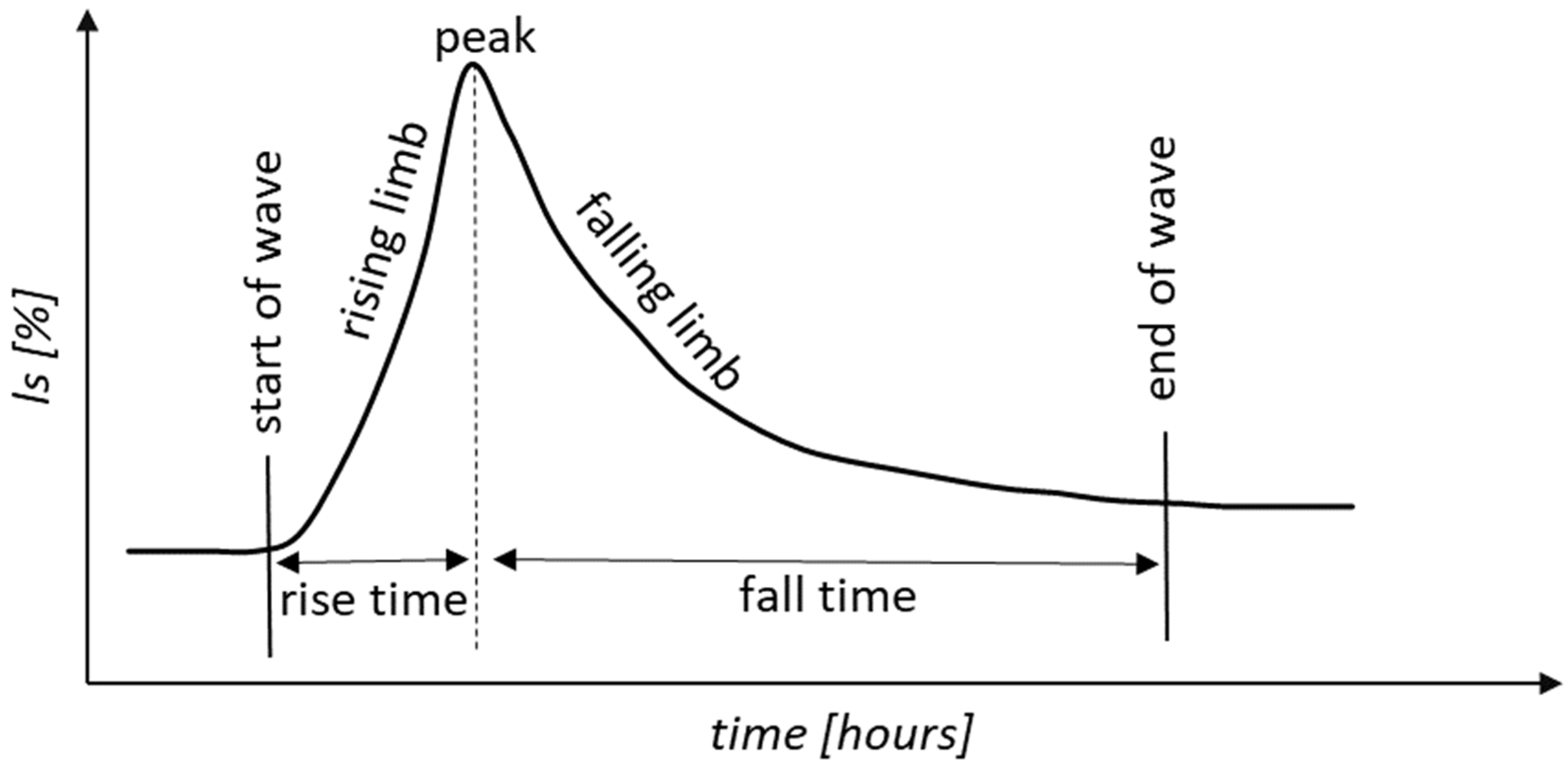
Parameters of the waves showing the course of the suspended solids load (peak, rise time, duration of the rising and falling phases) were determined by analyzing the sedimentogram (Figure 2). The beginning/end of the wave is at the point of inflection of the rising/falling limb, where an intensive increase/decrease in the share of suspended solids in the total loads of suspension and dissolved material begins.
In order to determine the functional dependencies, the relationships between the selected development indicators (the area of sealed areas and the density of roads and canals) and the average share of suspended solids in individual types of genetic floods were calculated. The relationships were determined separately for the rising and falling phases of the sedimentogram wave. The model adjusted R-squared values and p-values were reported. These optimal relationships are illustrated by graphs. All of the analyses were performed using Statistica software ver. 14.0 [60].

3. Results and Discussion

3.1. Hydrological and Fluvial Features of Floods of Various Origins—Statistical Approach

Statistical characteristics of selected flood parameters of diverse origins are presented in Figure 3. The analysis of the charts shows that with regard to all features, the urbanized catchments (Si4, Si5) stand out against the background of the discussed catchments. The highest average and maximum specific runoff were found in these catchments during floods caused by continuous rainfall (respectively: avg. 44.5 L∙s−1∙km−2 and max. 458.3 L∙s−1∙km−2 and 37.7 L∙s−1∙km−2 and 403.7 L∙s−1∙km−2). These catchments are also characterized by high values of the maximum specific runoff after rainstorm (Si4—458.3 L∙s−1∙km−2, Si5—291.7 L∙s−1∙km−2), exceeding more than 20 times the average specific runoff in other catchments during the same flood. It is interesting that the median of specific runoff during floods of snowmelt origin was the lowest in the urbanized catchments, although the maximum values observed in them were high and similar to those obtained in the suburban catchments (Su2, Si5). These results confirm the different importance of sealed surfaces in the process of runoff formation during diverse types of floods. Accelerated melting of the snow cover and increased evaporation within urban roads, car parks, developed areas, etc. (in February and March) reduce surface retention and, consequently, reduce river runoff during the main phase of spring or mid-winter snowmelt. On the other hand, high-intensity rainstorms (in July) accelerate the surface water runoff in the urbanized areas with significantly limited infiltration and interception.
In the outlets of the urbanized catchments (Si4, Si5), the highest concentrations of suspended solids occurred in all types of floods, especially the snowmelt-induced ones (Figure 3). Their maximum values were respectively: 1463 mg∙L−1 and 1112 mg∙L−1. Meanwhile, during the floods of the same origin, in the outlets of the forest and suburban catchments, they ranged from 34 mg∙L−1 (Su1—forest catchment) to 182 mg∙L−1 (Si2—suburban catchment). There were also no statistically significant differences between the medians in these catchments. The contrast in the course of suspended solids transport in the urbanized areas and other catchments was conditioned by the different size, efficiency and permeability of the supply areas and sources of sediment supply to the riverbeds that sometimes reach the watershed. The most efficient supply sources were roads and the rainwater drainage system, whose total density in the urbanized catchments reached 17.6 km∙km−2 and was then several times higher than in the forest catchments (2.5 km∙km−2). These roads mostly require winter maintenance treatments, i.e., the use of sand with salt [61].
During the floods caused by rainstorm, the highest spatial and temporal variation of Cs was also found in particular studied outlets (Figure 3). The maximum Cs in the outlet of the forest catchment was 42 mg∙L−1 (Su1), in the suburban area—117 mg∙L−1 (Su3), and below the centrum of Kielce, it reached as much as 865 mg∙L−1 (Si4). The average values of Cs in all the outlets of forest and suburban catchments were comparable with the values obtained in other upland catchments of central Poland [62]. The described distribution of suspension concentration indicates fundamental differences in the efficiency of supply sources and suspension transport mechanisms in the urbanized and other catchments. In the former, the efficiency of the sources of sediment supply to the canals and the dynamics of suspension transport were several times higher for similar specific runoff.
On the other hand, the floods caused by continuous rainfall are characterized by the lowest Cs values: medium (from 12 to 54 mg∙L−1) and maximum (from 52 to 546 mg∙L−1). Although the delivery of the suspended material from the urbanized areas still plays a dominant role here, due to the low average rainfall intensity, the time of its delivery to the riverbed is prolonged [63].
It is worth noting that a small water reservoir captures a significant part of the transported suspension during the year (approx. 16% during the year, and 12% during floods), which is reflected in lower values of Cs in the outlet Si3 recorded below the dam.
The highest concentration of dissolved material (Cd) was associated with the floods of snowmelt origin. In the winter season, a mixture of salt and sand is commonly used for the winter maintenance of roads, parking lots and sidewalks. Salt solutions are delivered to the riverbed by the surface runoff process [64]. In the urbanized catchment, the maximum Cd reached 1159 mg∙L−1 (Si4) (Figure 3), and in the forest catchment, it only reached 213 mg∙L−1 (Su1). In turn, the values of the average Cd in the same outlets were respectively: 479 mg∙L−1 and 138 mg∙Lv1. A similar spatial distribution of the concentration of this material, but with its lower values, was observed during the floods caused by rainfall (continuous, rainstorm).
The specific suspended sediment load (Ls) showed a very large spatial and temporal variation, clearly referring to the course of the specific runoff and the use of the catchment. As a result, its highest values Ls were recorded during the rainstorm-induced floods in the urbanized catchments (270 g∙s−1∙km−2—Si4, 187 g∙s−1∙km−2—Si5), and the lowest—in the forest catchments (2.1 g∙s−1∙km−2—Su1, 4.0 g∙s−1∙km−2—Si1). Similar relationships between the impact of the urbanized area and the size of the suspension load were indicated by Smith and Wilcock [12], and Russell et al. [65].
The floods of snowmelt origin and those associated with continuous rainfall were characterized by much lower values of discharged specific suspended sediment load. Gellis [51] drew attention to this phenomenon, indicating that long-term or previous rainfall events flush sediment from the system.
A characteristic feature of the specific dissolved material load (Ld) during floods of diverse origin was its relatively small spatial differentiation (Figure 3), conditioned mainly by the volume and variability of the specific runoff from the catchment in particular outlets. During the peak of the floods, the rivers are supplied with low-mineralized surface runoff water. Ld reached the highest values during the snowmelt. In the urbanized catchment, it was 98 g∙s−1∙km−2 (Si4), in the suburban catchment—30 g∙s−1∙km−2 (Su3) and in the forest only—11 g∙s−1∙km−2 (Su1).
The share of suspended solids (ls) in the fluvial transport of the two considered types of loads in the range of maximum values during the rainstorm floods varied from 19% (Si3—with a water reservoir) to 79% (Si4). The share was almost two times lower in the group of suburban catchments (40%), and the lowest—in the forest catchments (32%). A similar range of variabilities and their spatial arrangement was documented during the floods caused by continuous rainfall and snowmelt. The analysis showed that the origin of the flood did not determine the amount of suspended solids, but it was determined by the way the catchment was used.

3.2. Analysis of the Course of Selected Floods

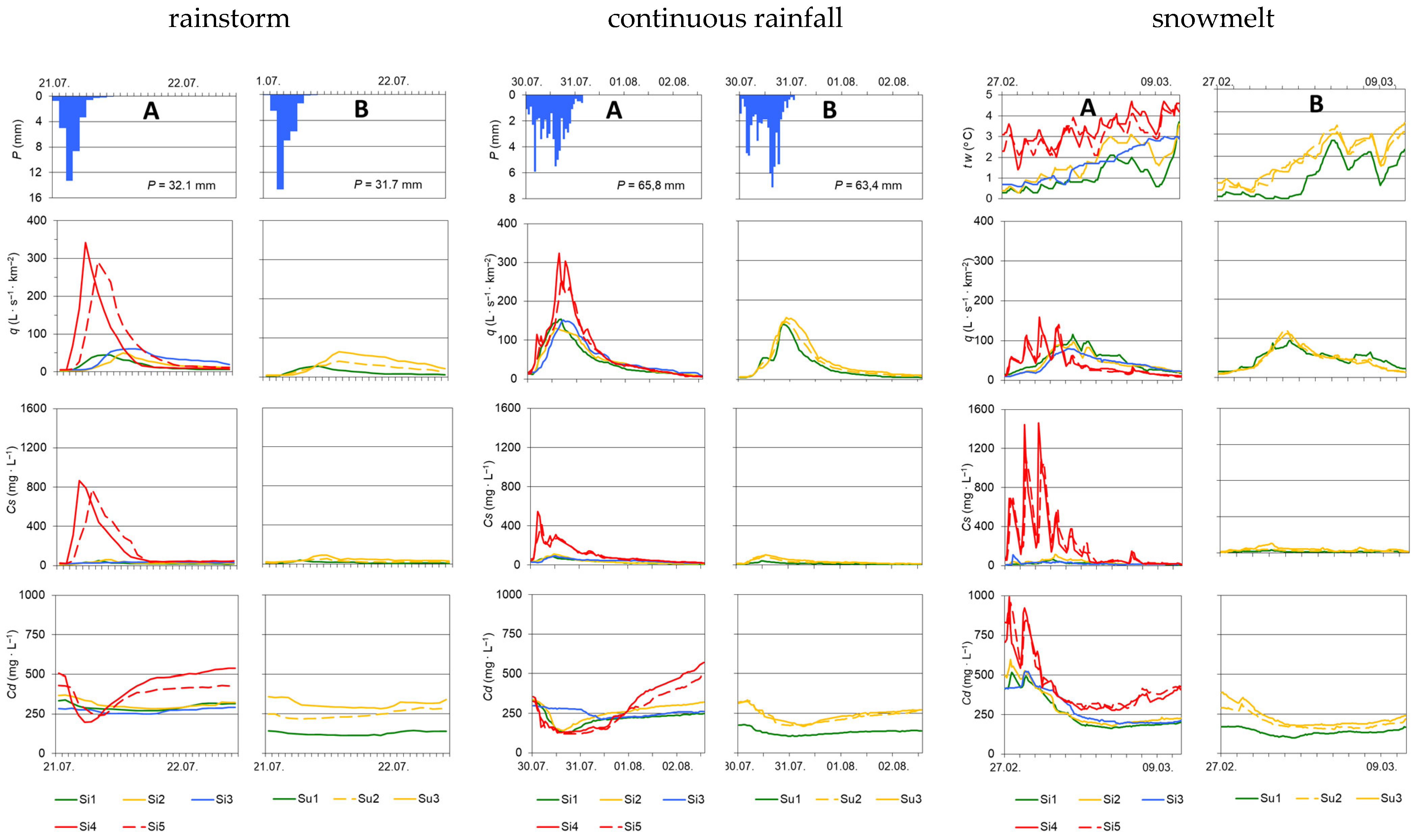
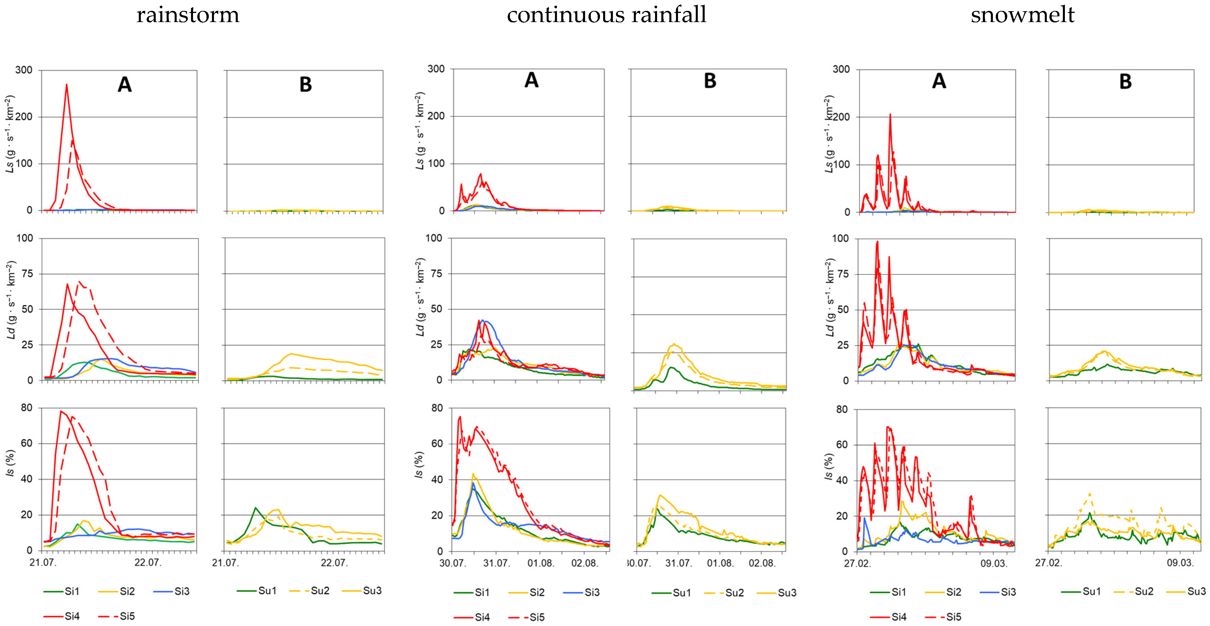
Out of 11 floods of diverse origin, one representative of each category, i.e., a flood caused by rainstorm, continuous rainfall and snowmelt, was selected for further detailed analysis of the suspension share. Firstly, selected hydrometeorological conditions of the occurrence of these hydrological events were presented (precipitation—during the rain-induced floods, water temperature—during snowmelt floods), and then the hydrographs for specific runoff, concentration of suspension and dissolved material (Figure 4) as well as their loads were showed on separate charts for the Silnica and the Sufraganiec catchments (Figure 5).

3.2.1. Causes of Floods

The flash flood on 21 July 2001 was caused by rainstorm with a rainfall total of 32.1 mm (over the Silnica catchment area) and 31.7 mm (the Sufraganiec catchment area) and the maximum hourly intensity of 13.3 and 14.6 mm∙h−1, respectively (Figure 4). The effective precipitation in the catchment of the Silnica reached 3.4 mm, and in the catchment of the Sufraganiec, it reached 5.7 mm. The surface runoff coefficient in the urbanized catchment (Si4) was then 46% higher than in the suburban catchment (Su3).
A flood caused by continuous rainfall occurred during 30 July–2 August 2000 and was caused by the rainfall lasting 28 h (in the Silnica catchment) and 26 h (in the Sufraganiec catchment), with a total amount and maximum intensity of 65.8 mm and 63.4 mm, and 5.9–7.1 mm∙h−1, respectively (Figure 4). In the Silnica catchment, the amount of effective precipitation was 19.1 mm, and in the Sufraganiec catchment, it was 11.6 mm. The preceding precipitation within 120 h was over 40 mm in both catchments [45].
A snowmelt flood (radiation type) in both catchments occurred during 27 February–10 March 1999 (Figure 4). In the first three days of the flood, the air temperature during the day increased to 7.1 °C, and at night it dropped to −4.3 °C. In the following days, the air temperature reached even 12.6 °C, and at night it did not fall below 0 °C. Within the city, as a result of a much faster increase in air temperature than in the neighboring areas, the snow cover started to melt faster, which contributed to an increase in the temperature of the river water (Figure 4). In the Silnica riverbed, the average water temperature increased in the section Si1–Si2, from 1.1 to 1.8 °C. Melting of the ice cover on the retention reservoir contributed to a slight drop in water temperature in the outlet of Si3 to 1.7 °C, and in another outlet located within the city (Si4) it increased abruptly to 3.3 °C. The snow cover pollution on roads, parking lots and sidewalks absorbed more sunlight and ablated faster. In this section of the Silnica, about 90 outlets of rainwater channels were documented, including eight (8) with permanent outflow, through which water with a temperature of several degrees higher than in the river flowed in. During this flood, the diurnal cycle of water temperature changes was particularly noticeable. They also had the lowest amplitude of water temperature. On the other hand, in the Sufraganiec riverbed, the average water temperature in the forest outlet (Su1) was 1.0 °C, and in the suburban one—1.9 °C (Su3).

3.2.2. River Runoff

During the flood caused by rainstorm, the maximum specific runoff (q) in the forest catchment (Su1) reached 38.3 L∙s−1∙km−2, while in the urbanized one (Si4)—348.1 L∙s−1∙km−2 (Figure 4). The surface runoff coefficient in the urbanized catchment of the Silnica reached 28.9% (Si4) and was higher than the value determined in the catchment of the Sufraganiec (18.3%—Su3). The flood wave concentration time in the Silnica catchment was 2.5 h, and in the Sufraganiec catchment—6.5 h.
The maximum specific runoff associated with continuous rainfall occurred in the urbanized catchments: in the catchment of the Silnica, it reached 306.2 L∙s−1∙km−2 (Si4), and in the catchment of the Sufraganiec 121.2 L∙s−1∙km−2 (Su3). The concentration time in the forest catchment was about 5 h longer than in the urbanized catchment.

3.2.3. Concentration of Suspended Solids

During the summer flash flood, the maximum Cs in the Su1 outlet (closing the forest catchment) was 27.9 mg∙L−1, and in the Si4 outlet (urbanized catchment), it was over 30 times higher and reached 865.3 mg∙L−1. It should be emphasized that in the studied catchments, concentration showed a similar spatial distribution to the specific runoff (Figure 4).
The highest values of Cs during the flood caused by continuous rainfall were found in the outlets closing the catchments with the highest degree of urbanization: Si4—545.9 mg∙L−1 and Si5—411.2 mg∙L−1. However, these values were much lower than during the flood caused by the rainstorm, while their spatial differentiation was similar. The maximum value of the Cs in the remaining catchments did not exceed 115 mg∙L−1 (Si2).
During the snowmelt-induced flood, the highest Cs was observed in the afternoon hours in the outlets of the urbanized catchments: 1463.2 mg∙L−1 (Si4) and 1112.3 mg∙L−1 (Si5) (Figure 4). At the same time, in the forest and suburban catchments, they ranged from 31.2 to 115.3 mg∙L−1. The contrast in the course of suspended solids transport in the urbanized and other catchments was conditioned by the different size, efficiency and permeability of the supply areas and sources of sediment supply to the riverbeds that sometimes reach the watershed. Roads were the most efficient supply sources here. A study by Bąk et al. [66] during a snowmelt flood (23 February 2012) in a stormwater catchment (62 ha) located in the city of Kielce showed that the average Cs was as high as 5514 mg∙L−1. The importance of roads in the delivery of sediment to river beds was presented in Poland [67,68,69,70,71].
The analyzed flood was preceded by a long period (38 days) with low water levels and snow cover. This favored the deposition of sand used for winter road maintenance. The peak of the suspended solids concentration in the examined outlets was delayed by several hours in relation to the peak of the discharge. The smallest differences in time were recorded in the outlets closing the urbanized catchments. Low water temperature during snowmelt floods causes its high viscosity, which favors the retention of clastic material in suspension and its transport over longer distances than during summer rain-induced floods [72,73].

3.2.4. Concentration of Dissolved Material

The greatest variation in the time of concentration and the peak of the dissolved material occurred in the flood caused by the rainstorms. In the first phase of the flood, the greatest decrease in the Cd was recorded in the outlets closing the urbanized catchments, and the smallest in the outlets: Si3 (below the water reservoir) and Su1 (forest catchment) (Figure 4). The decrease in Cd was the result of accelerated water circulation in the catchments with a large share of sealed surfaces, a dense drainage network and small retention capacity. In the Si4 and Si5 outlets, the lowest Cd (respectively: 199 and 241 mg∙L−1) occurred during the peak flow of the runoff, and in the remaining outlets with a delay of 1 to 7 h. It was related to the phenomenon of more concentrated waters being displaced by infiltrating rainwater. After the flood wave passed, the Cd increased the fastest in the outlets closing the urbanized catchments, reaching the pre-flood level after less than a day. It was there that the surface runoff ended the soonest and the river in this section was again supplied mainly with the water from the water reservoir and canals with a permanent outflow. In the latter case, the increased Cd was caused by impurities.
During the flood caused by continuous rainfall, in its first phase, the largest decrease in the Cd occurred in the outlets Si4 and Si5, and the smallest—in Si3 and Su1 (Figure 4). In the first case, it was related to the rapid surface runoff through the urban drainage system and direct precipitation onto the water surface of the riverbed which is wide in this section. Only in the Si4 and Si5 outlets, the lowest Cd (129 and 120 mg∙L−1) occurred during the peak flow of the runoff, in the others with a delay of 3 to 9 h, and below the water reservoir—only after 19 h. This delay resulted from the displacement of old highly-mineralized waters from the catchment area, including from the retention reservoir. The phenomenon of displacement of water from the catchment area during floods caused by continuous rainfall had been presented in many works [74,75,76]. Low Cd lasted the longest in the urban section of the Silnica. Due to the difficult infiltration, its supply with intra-cover runoff waters was the most limited here. In the remaining catchments, where the time of contact with the ground was longer, the increase in the Cd was faster. After the flood wave, the growth rate of Cd was the highest in the outlets located below the urbanized area. This is the result of a rapid change in the way the river is supplied, because surface runoff from the city area ended earlier than in other catchments, and at the same time the importance of subsurface runoff and water inflow from the upper part of the catchment, including the retention reservoir, has increased.
The highest Cd occurred in the first phase of the snowmelt flood, before the peak of the specific runoff. Its maximum values were recorded during the increase in flows in the afternoon, reaching in the urbanized catchments: 993 mg∙L−1 (Si4) and 956 mg∙L−1 (Si5) (Figure 4). At the same time, in the forest and suburban catchments, they ranged from 168 mg∙L−1 (Su1) to 519 mg∙L−1 (Si2). High values of Cd in the urbanized catchments and the increased ones in the suburban catchments resulted from the use of salt for winter road maintenance [77,78,79]. In the urban section, the supply of dissolved material to the canal clearly decreased only on the third day of the flood. During the peak flow of the runoff, the lowest Cd (98 mg∙L−1) occurred only in the Su1 outlet (forest catchment), and in the remaining outlets with a delay of 10 h (Su3) to about 60 h in the urbanized catchments (279 and 291 mg∙L−1). The largest shift in time in the outlets closing the urbanized catchments proves that the large resources of dissolved material originate from transport pollution. Then, a slow increase in Cd was recorded in all the outlets, and the largest was observed in the Si4 and Si5 outlets. According to [73], the increase in the Cd in the second phase of the flood is a reflection of the formation of supply sources during the flow regression.

3.2.5. Specific Suspended Sediment Load

During the flood caused by the rainstorm, the highest values of the specific suspended sediment load (Ls) and its greatest spatial differentiation were recorded (Figure 5). The maximum Ls occurred in the urbanized catchment—270 g∙s−1∙km−2 (Si4), and was similar to the load during an overflow in a small, urbanized catchment area [80]. Specific suspended sediment load in forest and suburban catchments did not exceed 4 g∙s−1∙km−2 (Su3).
The values of Ls during the flood caused by continuous rainfall were much lower (max. 79 g∙s−1∙km−2—Si4) and showed less spatial differentiation than during the flash flood (Figure 5). In the outlets of the forest and suburban catchments, the differences in suspended solids transport were not so clear and varied in the range from 2.9 g∙s−1∙km−2 (Su1) to 13.4 g∙s−1∙km−2 (Si2).
During the snowmelt flood, the Ls showed a greater daily irregularity than the runoff. In the urbanized catchments, the Ls reached the highest values: 207 g∙s−1∙km−2 (Si4) and 127 g∙s−1∙km−2 (Si5), and in the others only from 2.0 (Su1) to 10.1 g∙s−1∙km−2 (Si2) (Figure 5).
In general, regardless of the origin of the flood, the maximum transport of the suspension load took place during the peak of the flow or in the phase of wave propagation. Rivers with an unbalanced hydrological regime carry the majority of the annual load of the material during floods [46,81].
During the floods that occurred in the mountain catchments of southern Poland (Carpathians) and lasting up to a high percentage of days a year, over 95% of the annual Ls is carried away, and during catastrophic floods—even 10 times more than in an average year [73]. On the other hand, in the upland catchments of central Poland, the share of flood waters in the discharge of suspended solids reaches 70% of the annual load [82], and in the urbanized catchments, it may even exceed 90% [50]. The fluvial system associated with urban development favors the occurrence of extensive areas of linear sediment supply, which in many cases, may directly reach the watershed. In addition, poorly permeable or impermeable surfaces are conducive to the rapid formation of surface runoff and the flushing of particulate matter accumulated during rainless periods. Rivers draining the area of northern Poland (flowing into the Baltic Sea) discharge about 80% of the annual load of suspension during floods [76].

3.2.6. Specific Dissolved Material Load

During the flood caused by the rainstorm, the distribution of the dissolved material load (Ld) was clearly related to the course of the river outflow. The maximum values of Ld occurred in the urbanized catchments: Si4—68 g∙s−1∙km−2, Si5—70 g∙s−1∙km−2 and they coincided with the outflow peaks. On the other hand, in the suburban catchments, with the visible influence of urbanization processes, it varied from 9 g∙s−1∙km−2 (Su2) to 19 g∙s−1∙km−2 (Su3). In forest catchments, this load ranged from 3.3 g∙s−1∙km−2 (Su1) to 12.7 g∙s−1∙km−2 (Si1) (Figure 5).
A characteristic feature of the flood caused by continuous rainfall was a relatively low temporal and spatial variability of the Ld (15.4–42.4 g∙s−1∙km−2). The highest value was found in the Si3 outlet below the water reservoir, from which the retained water with an increased Cd material flowed out. Among the analyzed flood types, all the discharge curves of the Ld were most similar to the outflow hydrograph (Figure 5).
The Ld in the snowmelt flood showed a very large spatial and temporal variation, clearly referring to the use of the catchment area of the specific runoff course (Figure 5). The maximum values of the Ld occurred in the urbanized catchments: in the Si4 and Si5 outlets—99 and 85 g∙s−1∙km−2, respectively, and in the remaining areas, they ranged from 11.4 to 27.8 g∙s−1∙km−2 (Figure 5).

3.2.7. Share of Suspended Solids

The greatest spatial and temporal differentiation of the suspended solids (ls) share was recorded during the flash flood in July 2001. It is worth emphasizing that the sum of the 5-day rainfall preceding the flood was 34 mm, so the soil moisture conditions were close to average. The shortest time of concentration in the ls was observed in the outlets closing the urbanized catchments (Si4: t = 3 h, ls = 76.7%; Si5: t = 5 h, ls = 73.2%). At the same time, in the remaining outlets, this share ranged only from 5.7% to 9.0%, and peaked after 6–15 h. The maximum ls were much lower than during floods of another origin (Si1: ls = 13.8%, Su3: ls = 20.7%). The most even course of the sedimentogram was recorded in the Si3 outlet located below the water reservoir (Figure 5).
During the largest rain-induced flood caused by continuous rain, the changes in the percentage of suspended solids in the total load showed a similar spatial distribution as in the previous flood, but in the urbanized catchments they reached lower values in the peaks, and in the remaining ones higher. The maximum ls was found after four (4) and five (5) hours from the beginning of the flood in the outlets closing the catchments with the highest degree of urbanization (Si4: ls = 75.4%, Si5: ls = 69.6%), while at the same time in the other catchments, it ranged from 4.0% (Su3) to 14.7% (Si1). It was only after 9–13 h that the maximum occurred in them, reaching 24.2% in Su1 and 43.5% in Si2 (Figure 5).

3.3. Average Share of Suspended Solids and Dissolved Material Loads during Floods

The research results concern 11 floods of diverse origin, including those caused by rainstorm and continuous rainfall (four and three, respectively) and spring and mid-winter snowmelt (four).
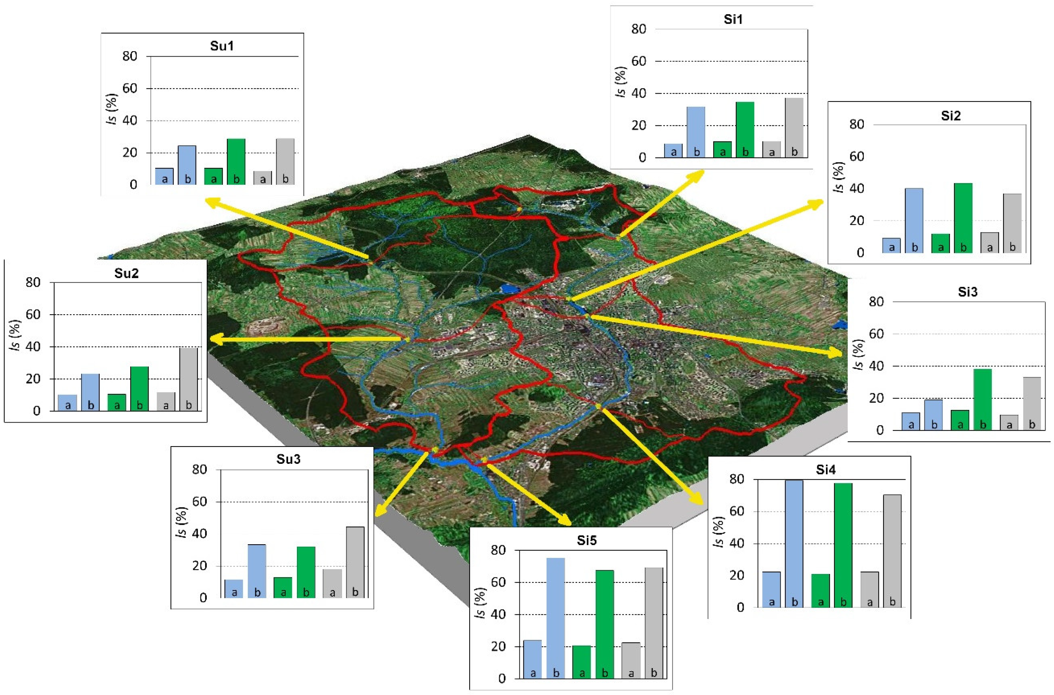
During the floods caused by rainstorm, the average value of the percentage share of the suspended solids load in the total loads (dissolved material and suspended solids) was significantly different in urbanized areas and other catchments (forest and suburban) (Figure 6). In the former, the average ls was over two times higher. In the Si4 outlet, it amounted to 24.5%, and in the Si5 outlet 25.9% (Table 2). The highest hourly ls occurred in the above-mentioned outlets, reaching 79.3% and 75.3%, respectively. In the catchments with other use, this share did not exceed 40%, which indicates the dominant importance of the transport of dissolved material in all phases of the flood (Figure 6, Table 2).
During the floods caused by continuous rainfall, the average ls was still recorded in the urbanized catchments, but with less dominance in comparison to flash floods. A decrease in these values was documented only in the former, both in terms of the average and maximum values (Table 2).
During the snowmelt-induced floods, both the average and maximum values of ls in the outlets located below the city center were documented, but the latter were the lowest among the discussed types of floods (70.3%—Si4, 69.3%—Si5). During the snowmelt floods in as many as four outlets, the highest values of the ls were recorded (Figure 6, Table 2).
The variability of the suspended solids transport during the year is mainly influenced by the dynamics of snowmelt and the amount and intensity of the rainfall, as well as the stock and the possibility of supplying the material from various sources. During floods, the major volume of the annual load of suspended solids is carried out of the catchment. During catastrophic floods, the load carried may be greater than during several “average” years [2,73,83]. For example, from the catchment area of Kamienica Nawojowska in 1970, as much as 99.7% of the annual Ls was discharged during floods [84]. Such transport dynamics characterizes mountain rivers with high flow irregularities. Upland rivers, characterized by moderate irregularity of flow, discharge a smaller Ls during floods [54,85]. For example, the Biała Nida discharges up to 71% of the annual Ls during floods [62], and the Łososina up to 89% [86].
The average time of occurrence of the maximum ls shows a great diversity depending on the flood origin and land use in catchments. The shortest average concentration time characterized the floods caused by rainstorm: from 4.3 to 5.5 h in the outlets of urbanized catchments, 6.5–8.0 h in the forest catchments, and 7.5–12.3 h in the suburban catchments (Figure 7). The average number of hours counted until the peak of the suspended solids share during the flood caused by continuous rainfall ranged from 9.7 h (Si4) to 24 h in the catchment with a water reservoir (Si3). Definitely the longest concentration times were recorded during the snowmelt floods, but their spatial arrangement was similar to the previous one (Si4—20.8 h, Si3—33.8 h) (Figure 7).
Based on the conducted analysis, the distribution of the ls in the longitudinal profile of the Silnica was significantly influenced by the water reservoir located above the Si3 outlet. This reservoir, despite the fact that it is small and flows through, modifies the share of the suspended solids transport, i.e., it “quenches” it during the floods caused by rainstorm, and increases its value during the floods caused by continuous rainfall and snowmelt.

3.4. Selected Characteristics of Catchment Use Vs. the Share of Suspended Solids during Floods

The above analyses showed that the percentage share of the suspended solids (total of two loads: suspended solids and dissolved material) in the particular outlets of the Silnica and the Sufraganiec was clearly differentiated and conditioned by the manner of use of particular catchments. In order to determine the functional dependencies, the relationships between the selected development indicators (the area of sealed areas and the density of roads and channels) and the average share of suspended solids in particular types of genetic floods were calculated. The relationships were determined separately for the rising and falling phases of the sedimentogram wave. This is due to a different mechanism of load delivery to the riverbed and fluvial transport processes.
With the increase in the catchment management indices, the share of the suspended solids load in relation to the dissolved material increased in all types of floods. In their initial phases, the growth gradient was definitely higher than in the phases after the peak. The relationships are described by logarithmic equations with high coefficients of determination, at the significance level from 0.001 to 0.01 (Figure 8). With regard to the area of sealed areas, as the areas of material and water supply to riverbeds, the highest value of the coefficient of determination was reached in the rising phase of waves caused by rainstorm (adj. R2 = 0.89), and the lowest—by snowmelt (adj. R2 = 0.79). In the falling phase, the empirical data matched slightly less in the above-mentioned types of waves, except for the floods caused by continuous rainfall (adj. R2 = 0.90). Similar relationships between these variables (with a high Pearson correlation coefficient) in relation to the flood waves in the streams of eastern Melbourne were presented by [87]. The positive correlation with more than 99% confidence between and human activities across a wide area of central Japan was presented Siakeu et al. [88].
The impact of the density of roads and channels as a drainage system of the catchments (especially the urbanized ones) turned out to be even more important than the one discussed above, as higher values of determination coefficients were obtained both in the rising and falling wave phases in all types of floods. In the rising wave phase during the rain/induced floods, higher matching values were obtained (adj. R2 = 0.94–0.95) than in the snowmelt flood (adj. R2 = 0.89). In the rising flood phase, the coefficients of determination were slightly lower and shaped in a similar way in all the analyzed flood types (rainfall: adj. R2 = 0.91–0.95; snowmelt adj. R2 = 0.78). It should be noted that the largest deviations from the trend line were recorded in the Si3 outlet, which is related to, among others, the sedimentation of the suspended solids and debris dragged in the bowl of the reservoir, as well as with the precipitation and absorption of chemical substances taking place in it.
The conducted analysis indicates that in the studied catchments, as the sealed surfaces, including hardened roads, and the density of the road and channel network increase, the value of the average ls during floods of diverse origins will continue to increase. Despite some similarities, it should be emphasized that the share of Ls compared to the load of dissolved material Ld will be the highest during flash floods and the lowest during snowmelt.

4. Conclusions

In the rivers draining small catchments located in Kielce, as in the whole of Poland, in terms of annual average values, the transport of dissolved material definitely dominates over the clastic material. However, during floods, this relation changes significantly, especially in the urbanized catchments.
This is the result of the impact of diverse areas and sources of supply affecting the mechanisms of clastic and dissolved material supply to riverbeds and its discharge. The internal structure of fluvial transport indicates that it is a reflection of the dominant type of land use in the catchment, under conditions of diverse anthropopressure. The variability of the mutual relations between the two types of loads discharged from the river catchments depends on the genetic type of the flood and its phase. It is particularly visible in the urbanized catchments, where the outflow regime is unbalanced and resembles the outflow rhythm of mountain rivers.
During floods of diverse origin, the average percentage share of the suspended solids load in the total load of suspended solids and dissolved material differs significantly. The highest spatial and temporal differentiation of the ls was observed during the rain-induced floods (caused by both the rainstorm and the continuous rainfall). Its largest share occurred in the outlets of the urbanized catchments and reached 80%, and in the remaining ones, it ranged only from 4 to 15%. In the urbanized catchments, the time of occurrence of the maximum ls during the flash flood was definitely shorter than during the flood caused by the continuous rainfall. During the snowmelt floods, the ls showed a clear daily rhythm of changes (similarly to the runoff), which in turn was related to the changes in air temperature. This rhythm was particularly visible in the outlets located below the city center, i.e., those closing the sub-catchments with the largest sealed areas. In these outlets, the maximum ls was of approx. 70%, and in the outlets of the forest and suburban catchments—in the range of 6–19%.
The findings are:
  • The land use, and in particular, the share of sealed surfaces, the density of the drainage network, water reservoirs, regulation of riverbeds and seasonal human activity, including the use of sand and salt for winter road maintenance, modify (in the forest and suburban catchments) and determine (in the urbanized catchments) both the spatial and temporal distribution of the ls in the fluvial transport.
  • In the urbanized catchments, in comparison to the forest, agricultural and suburban ones, the role of summer rain-induced floods in shaping the outflow is clearly increasing, and of those caused by the snowmelt—in shaping the fluvial transport. The transformation of the flood waves of the suspended solids share in the urbanized areas consists, among others, a significant shortening of their concentration time in the first phase of the flood (rising limb).
  • Urbanized areas, compared to other types of land use of similar size, produce much more dissolved substances and fine-grained sediment, and this has a significant impact on the dynamics, size and variability of the share of particular types of load in fluvial transport during floods.
  • Defined relationships between selected indicators of management of particular sub-catchments and the ls in fluvial transport, with high and statistically significant coefficients of determination, make it possible to forecast changes in the structure of fluvial transport as anthropogenic transformations in the catchment increase.
The obtained results, in addition to the cognitive aspects, have a utilitarian significance because they have been used for almost 20 years in the spatial planning of Kielce, especially in the drafting of the documentation of hydrotechnical facilities for the purposes of their reconstruction, dredging riverbeds and organizing flood protection of the city [89]. The presented results constitute a case study and can be used for comparative analyses of catchments characterized by a similar way and arrangement of land use.

Author Contributions

Conceptualization, T.C. and R.S.; methodology, T.C. and R.S.; software, R.S.; validation, T.C. and R.S.; formal analysis, T.C. and R.S.; investigation, T.C. and R.S.; resources, T.C.; data curation, T.C.; writing—original draft preparation, T.C. and R.S.; writing—review and editing, T.C. and R.S.; visualization, T.C. and R.S. All authors have read and agreed to the published version of the manuscript.

Funding

This research was funded under the Jan Kochanowski University in Kielce grant agreement, number SUPB.RN.21.254.

Data Availability Statement

Not applicable.

Conflicts of Interest

The authors declare no conflict of interest.

References

  1. Grove, A.T. The dissolved and solid load carried by some West African rivers. J. Hydrol. 1972, 16, 287–300. [Google Scholar] [CrossRef]
  2. Froehlich, W. The carrying out of suspended and dissolved load in the Kamienica Nawojowska and Łubinka catchment basins during the flood in 1970. Stud. Geomorph. Carpatho-Balcanica 1972, 6, 105–119. [Google Scholar]
  3. Babiński, Z. The relationship between suspended and bed load transport in river channels. IAHS Publ. 2005, 291, 182–188. [Google Scholar]
  4. Alexandrov, Y.; Cohen, H.; Laronne, J.B.; Reid, I. Suspended sediment load, bed load, and dissolved load yields from a semiarid drainage basin: A 15-year study. Water Resour. Res. 2009, 45, W08408. [Google Scholar] [CrossRef]
  5. Martínez-Salvador, A.; Conesa-García, C. Estimation of suspended sediment and dissolved solid load in a Mediterranean semiarid karst stream using log-linear models. Hydrol. Res. 2019, 50, 43–59. [Google Scholar] [CrossRef] [Green Version]
  6. Merchán, D.; Luquin, E.; Hernández-García, I.; Campo-Bescós, M.A.; Giménez, R.; Casalí, J.; Del Valle de Lersundi, J. Dissolved solids and suspended sediment dynamics from five small agricultural watersheds in Navarre, Spain: A 10-year study. Catena 2019, 173, 114–130. [Google Scholar] [CrossRef]
  7. Gregory, K.J.; Walling, D.E. Drainage Basin: Form and Processes; Edward Arnold: London, UK, 1973. [Google Scholar]
  8. Zwoliński, Z. Geomorphic Adjustment of the Parsęta Channel to the Present-Day River Regime; Dokumentacja Geograficzna; Institute of Geography and Spatial Organization PAS: Warsaw, Poland, 1989. [Google Scholar]
  9. Smolska, E. Funkcjonowanie Systemu Korytowego w Obszarze Młodoglacjalnym na Przykładzie Górnej Szeszupy (Pojezierze Suwalskie); University of Warsaw: Warsaw, Poland, 1996. [Google Scholar]
  10. Krzemień, K.; Sobiecki, K. Transport of disolved and suspended matter in small catchments of the Wieliczka Foothills near Łazy. Prace Geogr. 1998, 103, 83–100. [Google Scholar]
  11. Chalov, S.; Zavadsky, A.; Belozerova, E.; Bulacheva, M.; Jarsjö, J.; Thorslund, J.; Yamkhin, J. Suspended and dissolved matter fluxes in the upper Selenga river basin. Geogr. Environ. Sustain. 2012, 5, 78–94. [Google Scholar] [CrossRef] [Green Version]
  12. Smith, S.; Wilcock, P. Upland sediment supply and its relation to watershed sediment delivery in the contemporary mid-Atlantic Piedmont (USA). Geomorphology 2015, 232, 33–46. [Google Scholar] [CrossRef]
  13. Zeleňáková, M.; Kubiak-Wójcicka, K.; Weiss, R.; Weiss, E.; Abd Elhamid, H.F. Environmental risk assessment focused on water quality in the Laborec River watershed. Ecohydrol. Hydrobiol. 2021, 21, 641–654. [Google Scholar] [CrossRef]
  14. Obolewski, K.; Habel, M.; Chalov, S. River sediment quality and quantity: Environmental, geochemical and ecological perspectives. Ecohydrol. Hydrobiol. 2021, 21, 565–569. [Google Scholar] [CrossRef]
  15. Szatten, D.; Habel, M.; Babiński, Z. Influence of Hydrologic Alteration on Sediment, Dissolved Load and Nutrient Downstream Transfer Continuity in a River: Example Lower Brda River Cascade Dams (Poland). Resources 2021, 10, 70. [Google Scholar] [CrossRef]
  16. Ciupa, T. Relations between fluvial load types in highland catchments of central Poland. In Hydrology in the Protection and Landscape Environment; II National Hydrological Congress of the Association of Polish Hydrologists; Magnuszewski, A., Ed.; Monographs of Committee of Environmental Engineering PAS: Warsaw, Poland, 2014; Volume 2, pp. 381–391. [Google Scholar]
  17. Gil, E.; Słupik, J. The influence of the plant cover and land use on the surface runoff and wash down during heavy rain. Stud. Geomorph. Carpatho-Balcanica 1972, 6, 181–189. [Google Scholar]
  18. Brinkmann, W.L.F. Dissolved and suspended loads of the regulated River Nidda in the Rhine-Main area. IAHS Publ. 1983, 141, 347–357. [Google Scholar]
  19. Lenzi, M.A.; Marchi, L. Suspended sediment load during floods in a small stream of the Dolomites (northeastern Italy). Catena 2000, 39, 267–282. [Google Scholar] [CrossRef]
  20. Cohen, H.; Laronne, J.B. High rates of sediment transport by flash floods in the southern Judean Desert, Israel. Hydrol. Process. 2005, 19, 1687–1702. [Google Scholar] [CrossRef]
  21. Alexandrov, Y.; Laronne, J.B.; Reid, I. Intra-event and interseasonal behaviour of suspended sediment in flash floods of the semiarid Northern Negev, Israel. Geomorphology 2007, 85, 85–97. [Google Scholar] [CrossRef]
  22. Kijowska, M.; Bochenek, W. Dynamics of suspended material carried out from the flysch Bystrzanka catchment during selected rainfall events in the period of 1997–2008. Quaest. Geogr. 2011, 30, 47–56. [Google Scholar] [CrossRef] [Green Version]
  23. Karimaee Tabarestani, M.; Zarrati, A.R. Sediment transport during flood event: A review. Int. J. Environ. Sci. Technol. 2015, 12, 775–788. [Google Scholar] [CrossRef] [Green Version]
  24. Gellis, A.C.; Myers, M.K.; Noe, G.B.; Hupp, C.R.; Schenk, E.R.; Myers, L. Storms, channel changes, and a sediment budget for an urban-suburban stream, Difficult Run, Virginia, USA. Geomorphology 2017, 278, 128–148. [Google Scholar] [CrossRef] [Green Version]
  25. Haddadchi, A.; Hicks, M. Understanding the effect of catchment characteristics on suspended sediment dynamics during flood events. Hydrol. Process. 2020, 34, 1558–1574. [Google Scholar] [CrossRef]
  26. Song, Y.; Song, X.; Shao, G.; Hu, T. Effects of Land Use on Stream Water Quality in the Rapidly Urbanized Areas: A Multiscale Analysis. Water 2020, 12, 1123. [Google Scholar] [CrossRef] [Green Version]
  27. Dymek, D.; Zgłobicki, W.; Baran-Zgłobicka, B. The Impact of Mosaic Land Use and Land Cover on the Quality of River Waters (Case Study: Lubelskie Province, E Poland). Land 2021, 10, 1318. [Google Scholar] [CrossRef]
  28. Jokiel, P. Woda na Zapleczu Wielkiego Miasta: Możliwości Wykorzystania i Problemy Ochrony Zasobów i Obiektów Wodnych w Małej Zlewni Strefy Podmiejskiej Łodzi; Uniwersytet Łódzki, IMGW: Warszawa, Poland, 2002. [Google Scholar]
  29. Akan, A.O.; Houghtalen, R.J. Urban Hydrology, Hydraulics, and Stormwater Quality. Engineering Applications and Computer Modeling; Wiley: Hoboken, NJ, USA, 2003. [Google Scholar]
  30. Barszcz, M.; Banasik, K. The analysis of flood phenomenon in urbanized catchment—Sluzew Creek case study (Suburb of Warsaw). In Hydrological Extremes in Small Basins; Chełmicki, W., Siwek, J., Eds.; Euromediterranean Network of Representative and Experimental Basins, Jagiellonian University, Institute of Geography and Spatial Management Cracow: Kraków, Poland, 2008; p. 25. [Google Scholar]
  31. Li, S.; Gu, S.; Liu, W.; Han, H.; Zhang, Q. Water quality in relation to land use and land cover in the upper Han River Basin, China. Catena 2008, 75, 216–222. [Google Scholar] [CrossRef]
  32. Mallin, M.A. Comparative impacts of stormwater runoff on water quality of an urban, a suburban, and a rural stream. Environ. Monit. Assess. 2008, 159, 475–491. [Google Scholar] [CrossRef]
  33. Jacobson, C.R. Identification and quantification of the hydrological impacts of imperviousness in urban catchments: A review. J. Environ. Manag. 2011, 92, 1438–1448. [Google Scholar] [CrossRef]
  34. Łajczak, A. Transport of suspended sediment by the Vistula River basin upstream of Kraków, southern Poland, and the human impact during the second half of the 20th century. IAHS Publ. 2012, 356, 49–56. [Google Scholar]
  35. McGrane, S. Impacts of urbanisation on hydrological and water quality dynamics, and urban water management: A review. Hydrol. Sci. J. 2016, 61, 2295–2311. [Google Scholar] [CrossRef] [Green Version]
  36. Bartnik, A. Mała Rzeka w Dużym Mieście. Wybrane Aspekty OBIEGU Wody na Obszarze Zurbanizowanym na Przykładzie Łódzkiej Sokołówki; Uniwersytet Łódzki: Łódź, Poland, 2017. [Google Scholar]
  37. Baran-Zgłobicka, B.; Godziszewska, D.; Zgłobicki, W. The Flash Floods Risk in the Local Spatial Planning (Case Study: Lublin Upland, E Poland). Resources 2021, 10, 14. [Google Scholar] [CrossRef]
  38. Yazdi, M.N.; Sample, D.J.; Scott, D.; Wang, X.; Ketabchy, M. The effects of land use characteristics on urban stormwater quality and watershed pollutant loads. Sci. Total Environ. 2021, 773, 145358. [Google Scholar] [CrossRef]
  39. Walling, D.E. Suspended sediment and solute yields from a small catchment prior to urbanization. In Fluvial Processes in Instrumented Watersheds; Gregory, K.J., Walling, D.E., Eds.; Institute of British Geographers: London, UK, 1974; pp. 169–192. [Google Scholar]
  40. Kibler, D.F. Urban Stormwater Hydrology; American Geophysical Union: Washington, DC, USA, 1982. [Google Scholar]
  41. Tramblay, Y.; Saint-Hilaire, A.; Ouarda, T.B.M.J.; Moatar, F.; Hecht, B. Estimation of local extreme suspended sediment concentrations in California Rivers. Sci. Total Environ. 2010, 408, 4221–4229. [Google Scholar] [CrossRef] [PubMed] [Green Version]
  42. Becouze-Lareure, C.; Dembélé, A.; Coquery, M.; Cren-Olivé, C.; Bertrand-Krajewski, J.-L. Assessment of 34 dissolved and particulate organic and metallic micropollutants discharged at the outlet of two contrasted urban catchments. Sci. Total Environ. 2019, 651 Pt 2, 1810–1818. [Google Scholar] [CrossRef] [PubMed]
  43. Ferreira, C.S.S.; Walsh, R.P.D.; Kalantari, Z.; Ferreira, A.J.D. Impact of Land-Use Changes on Spatiotemporal Suspended Sediment Dynamics within a Peri-Urban Catchment. Water 2020, 12, 665. [Google Scholar] [CrossRef] [Green Version]
  44. Ciupa, T.; Suligowski, R. Impact of the City on the Rapid Increase in the Runoff and Transport of Suspended and Dissolved Solids During Rainfall—The Example of the Silnica River (Kielce, Poland). Water 2020, 12, 2693. [Google Scholar] [CrossRef]
  45. Ciupa, T.; Suligowski, R.; Wałek, G. Impact of an urban area on the dynamics and features of suspended solids transport in a small catchment during floods. Ecohydrol. Hydrobiol. 2021, 21, 595–603. [Google Scholar] [CrossRef]
  46. Wolman, M.G.; Miller, J.P. Magnitude and frequency of forces in geomorphic processes. J. Hydrol. 1960, 68, 54–74. [Google Scholar] [CrossRef]
  47. Wotling, G.; Bouvier, C. Impact of urbanization on suspended sediment and organic matter fluxes from small catchments in Tahiti. Hydrol. Process. 2002, 16, 1745–1756. [Google Scholar] [CrossRef]
  48. Absalon, D.; Czaja, S.; Jankowski, A.T. Factors influencing floods in the urbanized and industrialized areas of the Upper Silesia Industrial Region in the 19th and 20th centuries (the Kłodnica catchment case study). Geogr. Pol. 2007, 80, 97–109. [Google Scholar]
  49. García–Ruiz, J.M.; Regüés, D.; Alvera, B.; Lana–Renault, N.; Serrano–Muela, P.; Nadal-Romero, E.; Navas, A.; Latron, J.; Martí–Bono, C.; Arnáez, J. Flood generation and sediment transport in experimental catchments affected by land use changes in the Central Pyrenees. J. Hydrol. 2008, 356, 245–260. [Google Scholar] [CrossRef] [Green Version]
  50. Ciupa, T. The Impact of Land Use Runoff and Fluvial Transport in Small River Catchments: Based on the Sufraganiec and Silnica Rivers (Kielce, Poland); Jan Kochanowski University of Humanities and Sciences: Kielce, Poland, 2009. [Google Scholar]
  51. Gellis, A.C. Factors influencing storm-generated suspended-sediment concentrations and loads in four basins of contrasting land use, humid-tropical Puerto Rico. Catena 2013, 104, 39–57. [Google Scholar] [CrossRef]
  52. Krajewski, A.; Gładecki, J.; Banasik, K. Transport of Suspended Sediment During Flood Events In A Small Urban Catchment. Acta Sci. Pol. Formatio Circumiectus 2018, 17, 119–127. [Google Scholar] [CrossRef]
  53. Ciupa, T. Hydrological effects of urbanization as exemplified by the Silnica and Sufraganiec river catchments (Kielce, Poland). Folia Geogr. Ser. Geogr.-Phys. 2009, 40, 5–25. [Google Scholar]
  54. Michalczyk, Z. (Ed.) Ocena Warunków Występowania Wody i Tworzenia się Spływu Powierzchniowego w Lublinie; Wyd. UMCS: Lublin, Poland, 2012. [Google Scholar]
  55. Available online: https://meteomodel.pl (accessed on 1 September 2022).
  56. Available online: https://bdot10k.geoportal.gov.pl (accessed on 1 September 2022).
  57. Szeląg, B.; Suligowski, R.; Studziński, J.; De Paola, F. Application of logistic regression to simulate the influence of rainfall genesis on storm overflow operations: A probabilistic approach. Hydrol. Earth Syst. Sci. 2020, 24, 595–614. [Google Scholar] [CrossRef] [Green Version]
  58. Suligowski, R. Maksymalny Wiarygodny Opad na Wyżynie Kieleckiej; Wyd. UJK: Kielce, Poland, 2013. [Google Scholar]
  59. Ciupa, T. Chemical denudation in the catchments of the Holy Cross Mts. and Nida Basin. Landf. Anal. 2012, 20, 9–16. [Google Scholar]
  60. TIBCO Statistica® User’s Guide, Version 14.0. December 2020. Available online: https://docs.tibco.com/pub/stat/14.0.0/doc/html/UsersGuide/GUID-058F49FC-F4EF-4341-96FB-A785C2FA76E9-homepage.html (accessed on 5 December 2022).
  61. Jackson, R.B.; Jobbágy, E.G. From icy roads to salty streams. Proc. Natl. Acad. Sci. USA 2005, 102, 14487–14488. [Google Scholar] [CrossRef] [PubMed] [Green Version]
  62. Ciupa, T. Współczesny Transport Fluwialny w Zlewni Białej Nidy; Wyd. WSP: Kielce, Poland, 1991. [Google Scholar]
  63. Froehlich, W. The role of land use in varying the suspended load during continuous rainfall (Kamienica Nawojowska catchment, Flysch Carpathians). Geogr. Pol. 1978, 41, 27–37. [Google Scholar]
  64. Prowse, C.W. The impact of urbanization on major ion flux through catchments: A case study in southern England. Water Air Soil Pollut. 1987, 32, 277–292. [Google Scholar] [CrossRef]
  65. Russell, K.; Vietz, G.; Fletcher, T.D. Global sediment yields from urban and urbanizing watersheds. Earth Sci. Rev. 2017, 168, 73–80. [Google Scholar] [CrossRef]
  66. Bąk, L.; Górski, J.; Górska, K.; Szeląg, B. Suspended Solids and Heavy Metals Content of Selected Rainwater Waves in an Urban Catchment Area: A Case Study. Ochr. Srod. 2012, 34, 49–52. [Google Scholar]
  67. Wałek, G. The Influence of Roads on Surface Runoff Formation in the Urbanized Area on the Example of Silnica River Catchment in Kielce; Jan Kochanowski University: Kielce, Poland, 2019. [Google Scholar]
  68. Froehlich, W.; Walling, D.E. The role of unmetalled roads as a sediment source in the fluvial systems of the Polish Flysch Carpathians. IAHS Publ. 1997, 245, 159–168. [Google Scholar]
  69. Kroczak, R.; Bryndal, T.; Bucała, A.; Fidelus, J. The development, temporal evolution and environmental influence of an unpaved road network on mountain terrain: An example from the Carpathian Mts. (Poland). Environ. Earth Sci. 2016, 75, 250. [Google Scholar] [CrossRef]
  70. Bryndal, T.; Kroczak, R. Reconstruction and characterization of the surface drainage system functioning during extreme rainfall: The analysis with use of the ALS-LIDAR data-the case study in two small flysch catchments (Outer Carpathian, Poland). Environ. Earth Sci. 2019, 78, 215. [Google Scholar] [CrossRef]
  71. Zgłobicki, W.; Telecka, M.; Skupiński, S. Assessment of Short-Term Changes in Street Dust Pollution with Heavy Metals in Lublin (E Poland)—Levels, Sources and Risks. Environ. Sci. Pollut. Res. 2019, 26, 35049–35060. [Google Scholar] [CrossRef] [PubMed] [Green Version]
  72. Nordin, C.F. A Preliminary Study of Sediment Transport Parameters of Rio Puerco Near Bernardo, New Mexico; Professional Paper 462-C; United States Geological Survey: Washington, DC, USA, 1963. [Google Scholar]
  73. Froehlich, W. Mechanizm Transportu Fluwialnego i Dostawy Zwietrzelin do Koryta w Górskiej Zlewni Fliszowej; Institute of Geography and Spatial Organization PAS: Warsaw, Poland, 1982; Volume 143. [Google Scholar]
  74. Pearce, A.J.; Stewart, M.K.; Sklash, M.G. Storm runoff generation in humid headwater catchments. 1. Where does the water come from? Water Resour. Res. 1986, 22, 1263–1272. [Google Scholar] [CrossRef]
  75. Hooper, R.P.; Christophersen, N.; Peters, N.E. Modelling streamwater chemistry as a mixture of soilwater end members—An application to tile Panola Mountain catchment. J. Hydrol. 1990, 116, 321–343. [Google Scholar] [CrossRef]
  76. Kostrzewski, A.; Stach, A.; Zwoliński, Z. Transport of suspended load in the Parseta River during the flash flood of June 1988, Poland. Geogr. Pol. 1994, 63, 63–73. [Google Scholar]
  77. Löfgren, S. The chemical effects of de-icing salt on soiland stream water of five catchments in Southeast Sweden. Water Air Soil Pollut. 2001, 130, 863–868. [Google Scholar] [CrossRef]
  78. Thunqvist, E.L. Regional increase of mean chloride concentration in water due to the application of deicingsalt. Sci. Total Environ. 2004, 325, 29–37. [Google Scholar] [CrossRef]
  79. Gardner, K.M.; Royer, T.V. Effect of road salt application on seasonal chloride concentrations and toxicity in south-central Indiana streams. J. Environ. Qual. 2010, 39, 1036–1042. [Google Scholar] [CrossRef] [Green Version]
  80. Szeląg, B.; Górski, J.; Bąk, Ł.; Górska, K. The Impact of Precipitation Characteristics on the Washout of Pollutants Based on the Example of an Urban Catchment in Kielce. Water 2021, 13, 3187. [Google Scholar] [CrossRef]
  81. Święchowicz, J. Linkage of Slope and Fluvial Processes in Sediment and Solute Export from a Foothill Catchment in the Carpathian Foothills of South Poland; Institute of Geography and Spatial Management of the Jagiellonian University: Cracow, Poland, 2002. [Google Scholar]
  82. Świeca, A. Wpływ Czynników Antropogenicznych na Rzeczny Odpływ Roztworów i Zawiesin na Międzyrzeczu Wisły i Bugu; Rozpr. Habil. 61; UMCS: Lublin, Poland, 1998. [Google Scholar]
  83. Cyberski, J. Sedymentacja rumowiska w Zbiorniku Rożnowskim. Prace PIHM 1969, 96, 21–42. [Google Scholar]
  84. Froehlich, W. Dynamics of Fluvial Transport in the Kamienica Nawojowska; Geographical Studies PAS: Wroclaw, Poland; Warsaw, Poland, 1975; Volume 114. [Google Scholar]
  85. Rodzik, J.; Ciupa, T.; Janicki, G.; Kociuba, W.; Tyc, A.; Zgłobicki, W. Współczesne przemiany rzeźby Wyżyn Polskich. In Współczesne Przemiany Rzeźby Polski; Kostrzewski, A., Krzemień, K., Migoń, P., Starkel, L., Winowski, M., Zwoliński, Z., Eds.; Bogucki Wyd. Naukowe: Poznań, Poland, 2021; pp. 333–414. [Google Scholar]
  86. Biernat, T. Areas supplying weathered material and the mechanism of transportation of the suspended material in the Łososina catchment area (Holy Cross Mountain, central Poland). Quaest. Geogr. 1985, 1, 61–73. [Google Scholar]
  87. Hatt, B.; Fletcher, T.; Walsh, C.; Taylor, S.L. The Influence of Urban Density and Drainage Infrastructure on the Concentrations and Loads of Pollutants in Small Streams. Environ. Manag. 2004, 34, 112–124. [Google Scholar] [CrossRef] [PubMed]
  88. Siakeu, J.; Oguchi, T.; Aoki, T.; Esaki, Y.; Jarvie, H.P. Change in river in suspended sediment concentration in central Japan in response to late 20th century human activities. Catena 2004, 55, 231–254. [Google Scholar] [CrossRef]
  89. Ciupa, T.; Suligowski, R. Water Problems in Urban Areas. In Quality of Water Resources in Poland; Zeleňáková, M., Kubiak-Wójcicka, K., Negm, A., Eds.; Springer International Publishing AG: Berlin/Heidelberg, Germany, 2021; pp. 399–422. [Google Scholar]
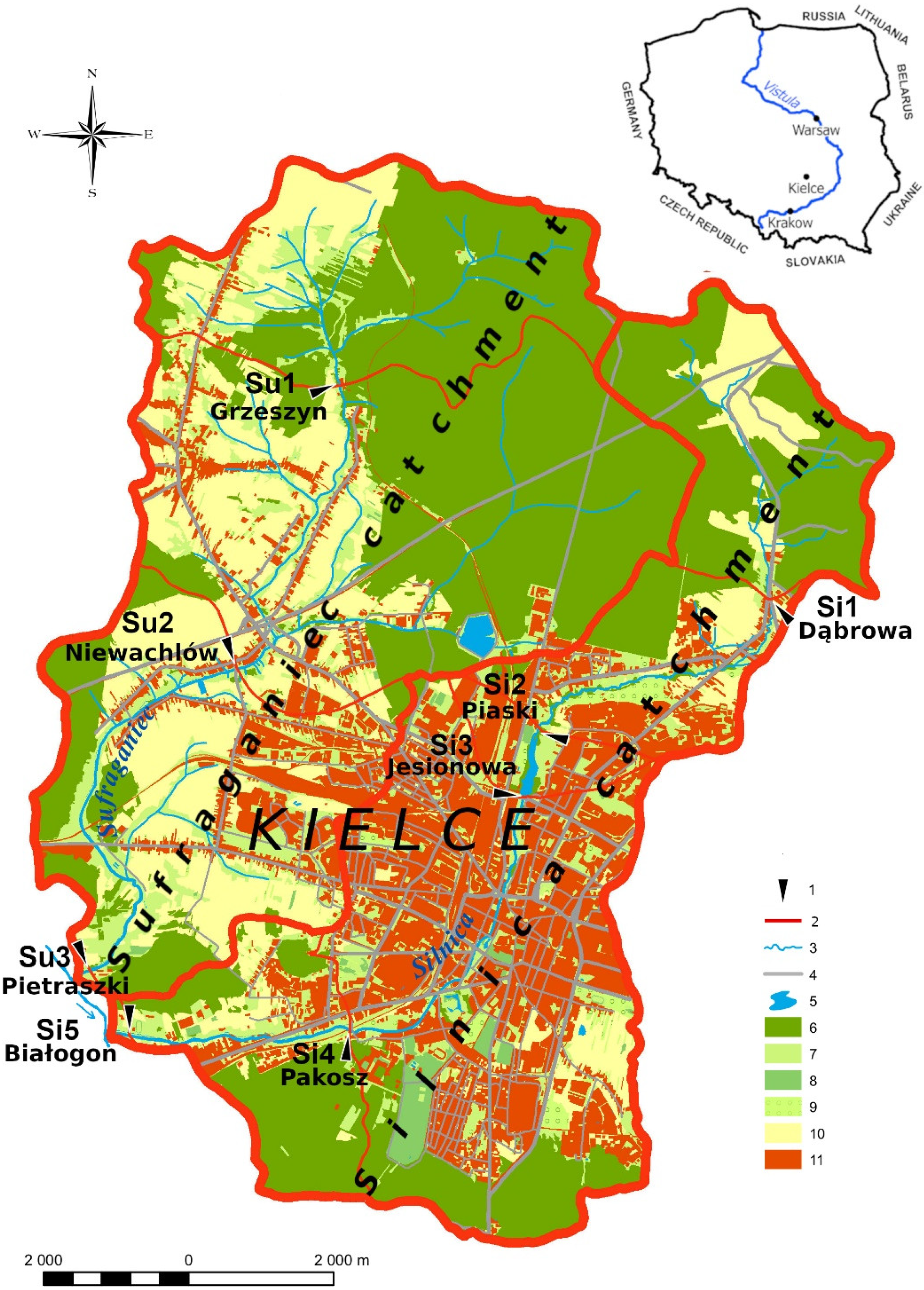
Figure 1. Land use and outlets in the Silnica and Sufraganiec catchments. 1—outlet, 2—watershed divide, 3—river, 4—road, 5—water reservoirs, 6—forests, 7—permanent grassland, 8—green areas, 9—orchards and gardens, 10—arable land, 11—impervious areas (buildings, roads, parking lots, etc.). Source: own study based on the Topographic Data Base BDOT10k [56].
Water 15 00090 g001
Figure 2. Illustration (interpretation) of different wave characteristics.
Water 15 00090 g002
Figure 3. Statistical characteristics of specific runoff (q), concentration of suspended solids (Cs) and dissolved material (Cd), specific suspended sediment load (Ls), specific dissolved sediment load (Ld) and share of suspension load (Ls) during floods caused by rainstorm (blue), continuous rainfall (green) and snowmelt (gray) in the catchments of Silnica (A) and Sufraganiec (B).
Water 15 00090 g003
Figure 4. Course of precipitation (P), water temperature (tw), specific runoff (q), suspension concentration (Cs), concentration of dissolved material (Cd) during selected floods caused by rainstorm, continuous rainfall and snowmelt in the catchments of the Silnica (A) and the Sufraganiec (B). The colors indicate catchment areas: red—urbanized, orange—suburban, green—forest, blue—with a water reservoir. For the snowmelt flood, the shape of its wave and its parameters in the forest and suburban catchments were similar. The peak of the runoff occurred on the fifth day from the beginning of the flood, and the maximum specific runoff ranged from 94.0 L∙s−1∙km−2 (Su1) to 121.3 L∙s−1∙km−2 (Su2). The most even runoff occurred in the Si3 outlet, which was influenced by the retention reservoir. The maximum specific runoff reached the value of 79.1 L∙s−1∙km−2, whereas the largest daily amplitude of runoff changes occurred in the outlets located below the city center (Si4 and Si5). This intensification of the dynamics of the daily rhythm of runoff is a characteristic feature of urbanized catchments. During this flood, there were several distinct runoff peaks, and the largest of them (respectively: Si4—159.5 L∙s−1∙km−2 and Si5—140.2 L∙s−1∙km−2) took place two days ahead of the peaks in the remaining outlets. The reasons for this phenomenon include limited infiltration, earlier melting of the snow cover and acceleration of surface runoff in the urbanized areas. In these two outlets, on the fifth day from the beginning of the flood, a fairly rapid decrease in the runoff was noted, while in the other outlets, it was only when the culmination occurred. Significant shortening of the flood wave subsidence time in the urbanized catchments is the result of limited, and in some places, even disappearing, subsurface and groundwater runoff. A similar mechanism of formation of the meltwater runoff and its spatial variation were documented during other floods of this origin [50].
Water 15 00090 g004
Figure 5. Specific suspended sediment load (Ls) and specific dissolved sediment load (Ld) and share of suspended load (ls) during floods caused by rainstorm, continuous rainfall and snowmelt in the catchments of the Silnica (A) and the Sufraganiec (B). Colors represent catchments: red—urban, orange—sub-urban, green—forest, blue—with a reservoir during a typical radiation snowmelt flood, the daily rhythm of changes in the ls in the studied outlets was related to changes in air temperature. It was particularly clear in the Si4 and Si5 outlets. At that time, the highest ls and its high daily variation were recorded there. Its highest values (respectively: 70.3% and 69.2%) were observed in the afternoon, in the 50th and 54th hour from the beginning of the flood. At the same time, in other sections, it ranged from 6.3% (Si3) to 19.1% (Su3). However, the largest ls (respectively: 10.4% and 32.0%) occurred here only after 102 and 74 h from the beginning of the flood (Figure 5).
Water 15 00090 g005
Figure 6. Average (a) and maximum (b) values of the hourly share of the suspended solids load (ls in %) in the total load (Ls + Ld) during floods caused by rainstorm (blue), continuous rainfall (green) and snowmelt (gray) in the catchments of the Silnica and the Sufraganiec.
Water 15 00090 g006
Figure 7. Average number of hours counted until the peak of ls share (%) (rising time) in the catchment of the Silnica outlets (A) and the Sufraganiec outlets (B). 1—rainstorm, 2—continuous rainfall, 3—snowmelt.
Water 15 00090 g007
Figure 8. Relations between the indicators: average share of sealed areas (Ia %) and density of roads and channels Drc (km·km−2) and the share of suspended solids load (ls %) in three (3) types of floods in their rising (solid line) and falling (dashed line) phases, in the catchments of the Silnica and the Sufraganiec. Colors indicate catchment areas: red—urbanized, orange—suburban, green—forest, blue—with a water reservoir.
Water 15 00090 g008
Table 1. Physiographic parameters and selected types of land use and land use indicators for the Sufraganiec and Silnica river catchments. Colors represent catchments: red—urban, orange—sub-urban, green—forest, blue—with a reservoir.
RiverOutlet
(Name)
Physiographic ParametersLand Use
Area
(km2)
River Lenght
(km)
Mean SlopeAverage Catchment Height
(m asl.)
Forests
(%)
Meadows
(%)
Arable Land
(%)
Impervious Areas
(%)
Density
of Road Network
(km·km−2)
Density of Covered and Open Canals (km·km−2)
River (‰)Catchment (‰)
SilnicaSi1 (Dąbrowa)9.234.2714.8664.5360.872.912.93.64.64.841.16
Si2 (Piaski)15.488.7811.6659.0339.051.215.09.912.76.081.58
Si3 (Jesionowa)17.889.8810.6758.8331.844.915.39.117.47.141.99
Si4 (Pakosz)42.614.498.3752.0302.429.616.34.330.212.674.97
Si5 (Białogon)49.3717.817.3353.2297.432.717.04.127.611.834.65
SufraganiecSu1 (Grzeszyn)13.614.5020.9868.1355.765.511.717.01.72.030.46
Su2 (Niewachlów)42.259.6912.0854.3330.459.09.723.03.42.880.83
Su3 (Pietraszki)61.9315.888.3848.8313.046.714.725.76.75.271.72
Table 2. Average and maximum values of the hourly share of the suspended solids load (ls in %) in the total load (Ls + Ld) during floods of diverse origins.
RiverOutletls (%)
Rainstorm (N = 4)Continuous (N = 3)Snowmelt (N = 4)
MeanMaxMeanMaxMeanMax
SilnicaSi110.131.810.634.810.437.5
Si211.640.112.643.512.837.0
Si310.519.012.538.39.832.9
Si424.579.322.677.624.070.3
Si525.975.323.269.624.869.3
SufraganiecSu110.124.310.928.79.028.7
Su210.223.211.127.812.239.3
Su312.835.713.132.017.544.4
The bolded font indicates the maximum value in the particular outlet. Colors represent catchments: red—urban, orange—sub-urban, green—forest, blue—with a reservoir.
Disclaimer/Publisher’s Note: The statements, opinions and data contained in all publications are solely those of the individual author(s) and contributor(s) and not of MDPI and/or the editor(s). MDPI and/or the editor(s) disclaim responsibility for any injury to people or property resulting from any ideas, methods, instructions or products referred to in the content.