Article

Signatures of Urbanization in Temperate Highland Peat Swamps on Sandstone (THPSS) of the Blue Mountains World Heritage Area

School of Science, Western Sydney University, Locked Bag 1797, Penrith, NSW 2751, Australia
*
Author to whom correspondence should be addressed.
Water 2022, 14(22), 3724; https://doi.org/10.3390/w14223724
Submission received: 8 October 2022 / Revised: 14 November 2022 / Accepted: 14 November 2022 / Published: 17 November 2022
(This article belongs to the Section Soil and Water)

Abstract

:
Urban freshwater ecosystems exhibit distinct patterns of elevated major ions (calcium, potassium and bicarbonate) and metals, referred to as the ‘urban geochemical signature’. However, the implications of this urban fingerprint at the water-sediment interface within sensitive freshwater systems are not well-known. Temperate Highland Peat Swamps on Sandstone are unique freshwater wetlands found within and surrounding the high-conservation value Greater Blue Mountains World Heritage Area and are a listed ‘endangered ecological community’ in Australia. Water and sediment chemistry were assessed within four urban and four naturally vegetated swamp catchments, through field monitoring and novel laboratory techniques (including X-ray diffraction). Urban swamps had distinct elemental signatures compared to naturally vegetated swamps. Urban swamp water displayed increased pH, elevated ionic strength, major ions (calcium and bicarbonate) and metals (strontium, barium, manganese and iron). Urban swamp sediment had higher calcium, with calcium hydroxide detected at two urban sites. Urban development and concrete drainage infrastructure in swamp catchments modify natural hydrology and water chemistry. Findings suggest swamp sediments may act as sinks of metals and alkalinity, with urbanization remaining a potential source. However, the consequences for high-conservation value systems are not well understood. As urbanization continues to expand, this has implications for fragile freshwater environments worldwide.

1. Introduction

Urbanization is a significant anthropogenic issue that is expanding on a global scale and placing increasing pressure on freshwater and terrestrial ecosystems [1]. Urban waterways exhibit key characteristics, including altered natural hydrology, modified water chemistry, elevated nutrient levels and alkalinization, termed ‘urban stream syndrome’ [2,3]. High coverage of impervious surfaces, such as concrete, building materials and stormwater infrastructure, contribute to increased surface runoff and are commonly associated with the degradation of water quality in urban areas [4,5]. Urban waterways worldwide are increasingly being recognized as exhibiting a distinct ‘urban geochemical signature’ [6], as urban inputs such as stormwater and weathering of urban infrastructure contribute to enhanced inputs of elements and nutrients, including elevated calcium, bicarbonate, potassium, magnesium and sulfate [7,8,9,10].
Sediments collected from urbanized catchments worldwide can be strongly impacted by urban development, with elevated metals and nutrient enrichment compared to sediment in non-urban catchments [11,12,13,14]. The sediment acts as a sink, particularly in urban ecosystems, as elements accumulate over time [15,16]. The transport and availability of sediment in urban waterways can be reduced by urban pavements, as measured by catchment imperviousness [11]. Increasing metal loads may drive structural breakdown [17] and result in increased elemental export [18]. This is particularly the case for peat swamps and wetland systems, with the sediment record indicating evidence of anthropogenic markers correlated with increasing human activities [19,20]. Sediment provides a temporal record of changes and can be used to understand changes to ecosystem function due to urbanization.
Increasingly, research has linked the weathering of urban derived materials, particularly the dissolution and weathering of concrete, with modified water chemistry including elevated calcium and modified pH [4,21,22,23,24]. The urban alkalinization process can be characterized as the dissolution of calcium hydroxide (lime; Ca(OH)2), a common component of concrete, which dissociates in the presence of water to increase pH to a potential maximum of 12.5 [25] Reaction 1. This can react with atmospheric carbon dioxide (CO2) and if this exceeds solubility precipitation of calcium carbonate (or calcite; CaCO3) can occur [25] Reaction 2. Previous research has also observed increased calcium concentrations in urban riparian sediment [12,14,26], which suggests that excess calcium may be accumulating in urban sediments.
Ca(OH)2(S) = Ca2+ + 2OH
Ca2+ + HCO3 → CaCO3(S) + H+
The Greater Blue Mountains Area (GBMA) was listed as a World Heritage Area in 2000 due to its exceptional biodiversity values that reflect unique evolutionary adaptations occurring within Australia since the post-Gondwana period [27,28]. Covering 1.04 million hectares, this region incorporates eight protected reserves, and areas of urban and agricultural land use in New South Wales (NSW), south-eastern Australia [29]. The ecological, cultural, and economic value of this region is significant within Australia and reflects Outstanding Universal Value (OUV), which emphasizes the importance of conserving the natural condition of this area [27,30]. The GBMA is managed under Federal and State legislation, including the Environment Protection and Biodiversity Conservation Act 1999 (Commonwealth; EPBC Act), the Biodiversity Conservation Act 2016 (NSW; BC Act), National Parks and Wildlife Act 1974 (NSW; NPW Act) and Wilderness Act 1987 (NSW) [27], and the Greater Blue Mountains World Heritage Area Strategic Plan [31]. This region is recognized to be vulnerable to the effects of climate change, bushfires and human activities such as mining [29,30]. Urban development is also a key concern, and as the population of Greater Sydney continues to expand this places increasing pressure on the fringing ecosystems of the GBMA [30,31]. The Blue Mountains, with a population of approximately 80,000, is one of two cities worldwide that is encompassed within a World Heritage National Park [32]. Management of the region and national parks seeks to protect natural environments from human degradation. However, urban development still occurs within the Blue Mountains, particularly along major highway corridors, which poses a threat to fragile natural environments within and along the national park boundaries in this region [29,30].
Temperate Highland Peat Swamps on Sandstone (THPSS) are unique peat swamps overlaying sandstone geology across the Blue Mountains and Southern Highlands regions that contain distinct vegetation communities dominated by sedges and shrubs [33,34]. They are listed as an ‘endangered ecological community’ under the EPBC Act 1999 (criterion two), as they have a limited geographic distribution and are at risk of ongoing threats [35]. They are also recognized as having important biodiversity value within the GBMA [30]. Many THPSS are found within the Blue Mountains region of NSW, west of Sydney, at altitudes of 500–1000 m and their distribution is restricted to a combined area of less than 2000 ha [36]. Urban encroachment within this region poses a threat to THPSS, including urban runoff, water pollution, weeds, and invasive species [30]. It is estimated that almost one third of THPSS are impacted by urbanization [37], and many swamp catchments occur along the fringe or fall outside the World Heritage boundary in urban centers of the Blue Mountains, making them vulnerable to habitat loss and degradation.
The effects of urban development on sediment structure, geomorphology and carbon storage [33,38,39], water chemistry [34,40] and potential differences in surface sediment elemental composition within urban swamp catchments in the Blue Mountains has been identified [40]. However, the potential influence of catchment urbanization on water chemistry and sediment mineralogy interactions has not been previously studied in these systems. This study aimed to further enhance knowledge of possible links between urban development, concrete materials, and physical and chemical properties of THPSS. The key questions addressed were: (i). Do urban swamps have modified water chemistry relative to naturally vegetated catchments; and (ii). Does sediment from urban swamps exhibit altered chemical composition and mineralogy compared to naturally vegetated catchments? The dilute, low nutrient and acidic nature of THPSS makes them a model system to investigate how urban inputs alter the natural geochemical signature of sensitive freshwater wetlands. As urbanization continues to expand globally, learnings from THPSS contribute to our understanding of how fragile freshwater environments might be impacted by urban geochemical modification.

2. Materials and Methods

2.1. Study Area

The geology of the Blue Mountains region is dominated by Permo-Triassic quartz sandstone and inter-bedded claystone [41,42]. THPSS are considered stable systems, with carbon dating of sediment cores dated to approximately 9000 to over 15,000 years [33,43]. THPSS in the Blue Mountains region experiences a temperate climate, with a mean annual rainfall of 1399.6 mm at Katoomba [44], however, during the sampling period conditions were dry and rainfall was below average. Water quality within THPSS is typically acidic, dilute, poorly buffered, and dominated by sodium and chloride [34,40].
This study was conducted at swamps from four urban and four naturally vegetated catchments across the Blue Mountains region, west of Sydney, NSW within the Hawkesbury-Nepean catchment (Table 1; Figure 1). These eight swamps do not represent swamps across the entire study area but were chosen to provide a broad assessment of urban land uses on a small number of THPSS. Urban (located on the national park fringe) and naturally vegetated (located within the GBMA) classifications were determined using satellite images to calculate the total percentage of impervious area (IA%) and the percentage of Directly Connected Impervious Area (DCIA%) of each catchment. This approach followed the methods outlined by [45], using the conservative assumption of low-density residential land use in each swamp catchment. All sites had vegetation communities consistent with the THPSS listing, however, urban sites were observed to have greater disturbance and a higher presence of exotic species.

2.2. Monitoring of Water Chemistry

Surface water was collected from the exit stream at each swamp on three occasions between April and June 2018. This study was the first of its kind in THPSS and did not aim to conduct a seasonal or multi-year investigation. The study included parameters that were shown to be important in contrasting water and sediment quality in urban and non-urban catchments in previous studies of THPSS [34,36,37,38,39,40]. This current study included more a detailed examination of several parameters, including nutrients, a more extensive suite of metals and conducted the first minerology examination of urban and non-urban THPSS sediment cores.
Water physiochemical properties (five repeated measures once the meter had stabilized) were tested in the field, including pH (pH units) and electrical conductivity (EC; μS cm −1) using a calibrated TPS AQUA-Cond-pH meter, and dissolved oxygen (DO; percentage (%)) and temperature (°C) using a calibrated YSI ProODO meter. Turbidity was tested using a HACH 2100P Turbidimeter (five replicates per swamp). Due to dry conditions, surface water at Mount Hay was only sampled in April 2018. Nutrients (nitrates (mg L−1 NO3) and reactive phosphates (mg L−1 PO43−)) were tested using a HACH Drel Spectro-photometer (DR/2400; cadmium reduction method 8171, calibrated as per manufacturer’s instructions), each with five replicates per swamp.
Duplicate 500 mL grab water samples were collected (unfiltered) from surface water in sterilized plastic containers, stored at 4 °C and acidified (0.1 mL of nitric acid) to preserve samples for cation and metal analysis. Determination of major ions and metals followed standard methods (APHA method 4110 and APHA method 2320-B, analyzed using inductively coupled plasma optical emission spectrometry (ICP-OES) and inductively coupled plasma mass spectrometry (ICP-MS) [47]). The major ions that were assessed included cations calcium, magnesium, potassium, sodium, and anions sulfate, chloride, bicarbonate and carbonate. Trace elements included aluminium, arsenic, barium, cadmium, chromium, cobalt, copper, iron, lead, lithium, manganese, molybdenum, nickel, strontium, titanium, uranium and zinc. As molybdenum and uranium were not detected at either catchment type, they were excluded from subsequent analysis.

2.3. Sediment Sample Collection and Testing

2.3.1. Sample Collection

Sediment cores were collected from each site over the course of two days using cleaned polyvinyl chloride (PVC) pipe (55 mm × 500 mm). All cores were collected in close proximity (5–20 m) to the swamp exit stream and main drainage channel. The top layer of vegetation was moved aside, and the pipe was eased in approximately 40 cm or until it hit the resistant layer. After extraction, cores were immediately wrapped in clingfilm and frozen (−18 °C) until analysis.
Frozen cores were thawed and the outer layer was cleaned away using a scalpel. The sediment color of each layer was determined using a Munsell Soil Color chart. A subsample (approximately 5–10 g) was collected from each layer from the center of the left-hand side of the core and placed in sterile PTFE tubes (50 mL). Once thawed, readings for pH (pH units; using a TPS Aqua-CP Conductivity/pH meter) and redox (Eh; measured in millivolts (mV) using a TPS WP-80D Dual pH-mV meter) were taken at 5 cm intervals along the right-hand side of the core. Samples from each core were dried in the PTFE tubes (with lid removed) in a Labec laboratory incubator S4218 (Laboratory Equipment Pty Ltd., Marrickville, Australia) for up to 48 h at 30 °C.

2.3.2. Mineralogy

The elemental composition and mineralogy of sediment samples from each layer per core was analyzed using a Bruker D8 Advance X-ray Diffractometer (XRD) with a copper K-alpha radiation source and LynxEye detector. All sediment samples were ground into a fine powder using a mortar and pestle. The analysis included a 5–80 degree 2θ scan (duration 4 h) with a step rate of 0.02 degrees, 3.5 s time per step and rotation off. A divergence and anti-scattering slit size of 12.0 mm and a generator voltage of 40 kV were used. Analysis of all XRD results was undertaken using Bruker’s EVA software [48], with spectra compared with CaCO3 and Ca(OH)2 standards using the Powder Diffraction File (PDF) database from the International Centre for Diffraction Data (ICDD).

2.4. Data Analysis

2.4.1. Statistical Analysis

Water quality data were analyzed using IBM SPSS Statistics version 22. Water physiochemical attributes, major anions and cations were averaged for each site. EC results from Lawson in June 2018 were excluded due to suspected equipment error and no water samples were obtained from Mount Hay from May-June 2018 due to dry conditions. Each water quality parameter was analysed using a mixed linear model, where the fixed factor was the catchment type and the random variable was the sampling event (to incorporate variability over time). For all analyses conducted, statistical significance was established at the 0.05 level. Any values that were below detection limits were attributed as half of the minimum detection value for analysis [7,49], however, were indicated as below detection in the figures shown. Principal Component Analysis (PCA) was conducted across all sites and sampling events using the ‘PCA’ function in the FactoMineR package in R v4.1.1 [50,51]. EC for Lawson for the second sampling event was averaged from the first and third sampling events for the purpose of the PCA analysis due to missing data. Mo and U were excluded from the PCA analysis as they were not detected at any sites.

2.4.2. Water Quality Modelling

The PHREEQC software program (version 3.1.7.9213) with the LLNL database package was used to calculate ionic activities and determine the ionic strength of water [52]. Phases considered included atmospheric carbon dioxide (pCO2 = −3.5), portlandite (log K = 22.55) and calcite (log K = 1.84). Solution speciation was calculated, and saturation index (SI) was determined based on SI = log IAP/Ks, where IAP indicates the ion activity product and Ks refers to the thermodynamic solubility product of the relevant phase.

3. Results

3.1. Water Chemistry

3.1.1. Physiochemical Properties

Urban swamps had significantly higher pH (mean 6.20 pH units), compared to the naturally vegetated catchments (mean 4.87 pH units), and the range of values did not overlap (p < 0.001; Table 2). EC in urban swamps (mean 116.30 µS cm −1) was 2.55 times greater than the non-urban catchments (mean 45.57 µS cm −1; p < 0.01). Mean DO was also 33.50% higher in the non-urban catchments compared to the urban sites (p < 0.01).
Nitrate and reactive phosphates concentrations showed no significant differences between urban and non-urban swamps (Table 2). Additionally, median reactive phosphate values were equal (0.20 mg L−1 PO43-) for each catchment type. Turbidity was not observed to significantly differ between catchment types, and there was variability between sampling events.

3.1.2. Water Ionic Composition of Major Cations and Anions

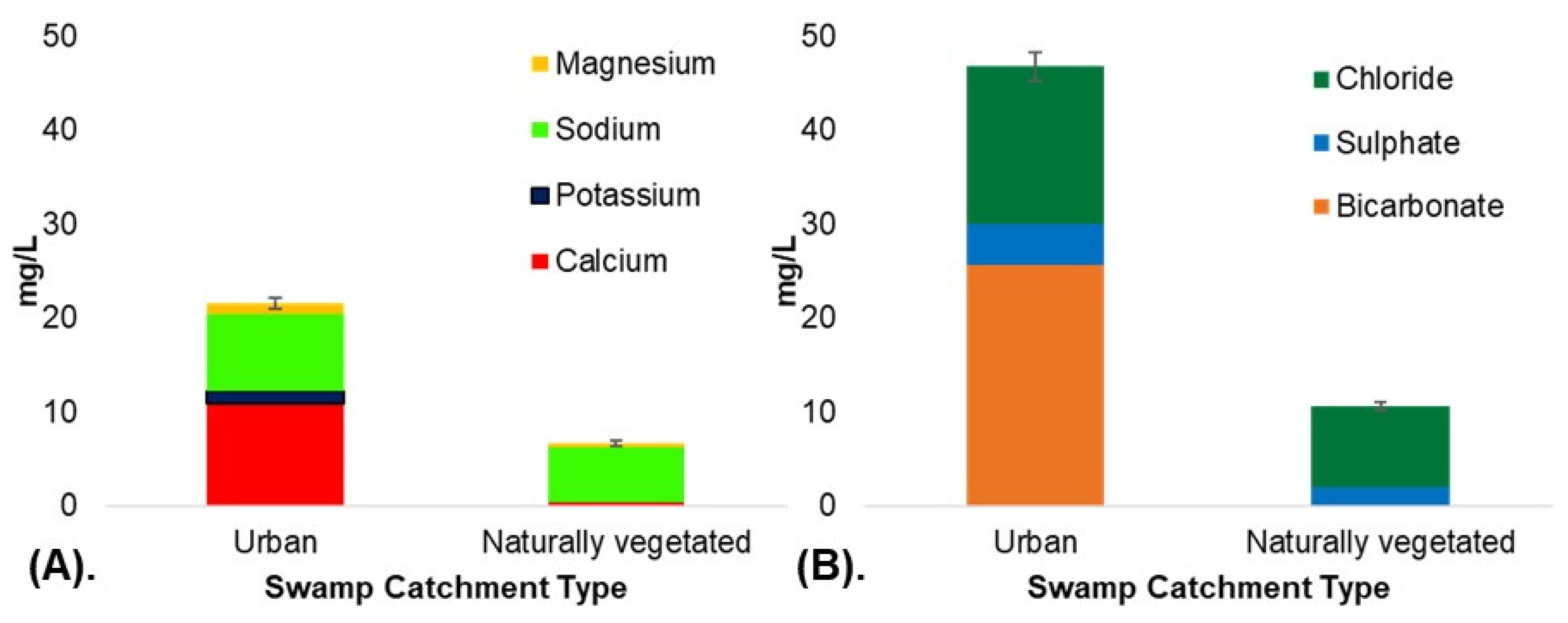
Urban swamp water exhibited differences in ionic composition compared to the naturally vegetated swamps (Table 3; Figure 2). Calcium was below detection in the naturally vegetated swamp catchments (excluding at Kings Tableland) and 19.82 times higher (mean 10.90 mg L−1) in the urban swamps (p < 0.001). Bicarbonate was below detection in all naturally vegetated swamps, however, was present in significantly higher quantities in the urban swamps (mean 25.67 mg L−1; p < 0.001). The ratio of Ca: HCO3- was 1:2 in naturally vegetated swamps and 1:1 in urban swamps (Table 3). Urban catchments also had significantly higher potassium, magnesium, chloride and sulfate concentrations compared to the non-urban swamps (Table 3). Sodium was naturally present at all sites, however, was significantly higher within the urban catchments (mean 8.19 mg L−1) compared to the non-urban swamps (mean 5.87 mg L−1; p < 0.001).
Ionic strength (IS) was greater in the urban swamp catchments (mean 0.0015 M) compared to the naturally vegetated catchments (mean 0.0004 M; Table 3). There was a strong correlation between IS and EC (R2 = 0.91; see Supplementary data Figure S1a). When calcium alone (converted to Moles) was compared with EC, the correlation was 0.82 (see Supplementary data Figure S1b), suggesting that calcium is contributing to the overall EC and ionic strength.

3.1.3. Elemental Loads

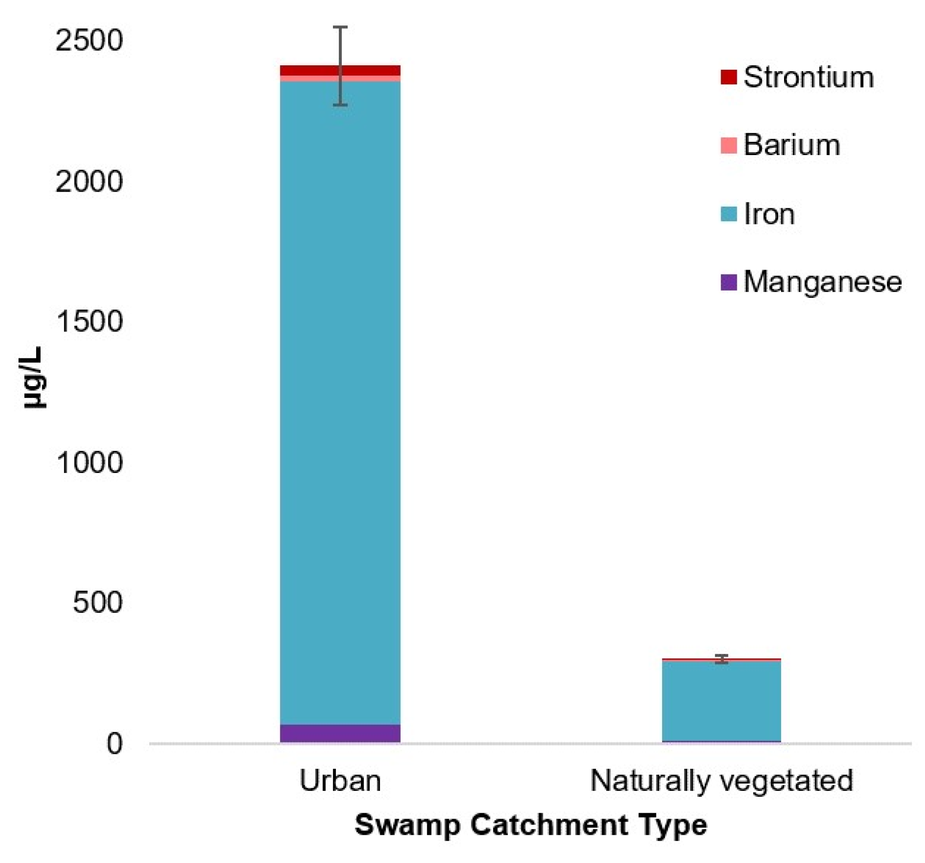
Urban swamps exhibited statistically significant differences in strontium, barium, manganese and iron, suggesting that the metal signature of the urban THPSS differs from naturally vegetated catchments (Table 4; Figure 3). A suite of metals not detected in the non-urban swamps were present in the urban catchments, however, these were not statistically significant. This included nickel, chromium, cobalt, arsenic and lithium (Table 4).
Strontium concentrations in urban swamps were 9.68 times higher than in naturally vegetated swamps (mean 37.26 µg L−1; p < 0.001). Urban swamps had significantly higher levels of barium, by 3.23 times, compared to the non-urban swamps (p < 0.001). Manganese was significantly higher within the urban (mean 68.93 µg L−1) compared to the naturally vegetated swamps (mean 9.73 µg L−1; p < 0.01). Iron was one of the most abundant elements detected across all sites, however, there was more than an eight-fold difference in iron concentrations between urban (mean 2288.10 µg L−1) and naturally vegetated (mean 281.73 µg L−1) catchments (Table 4; p < 0.001).
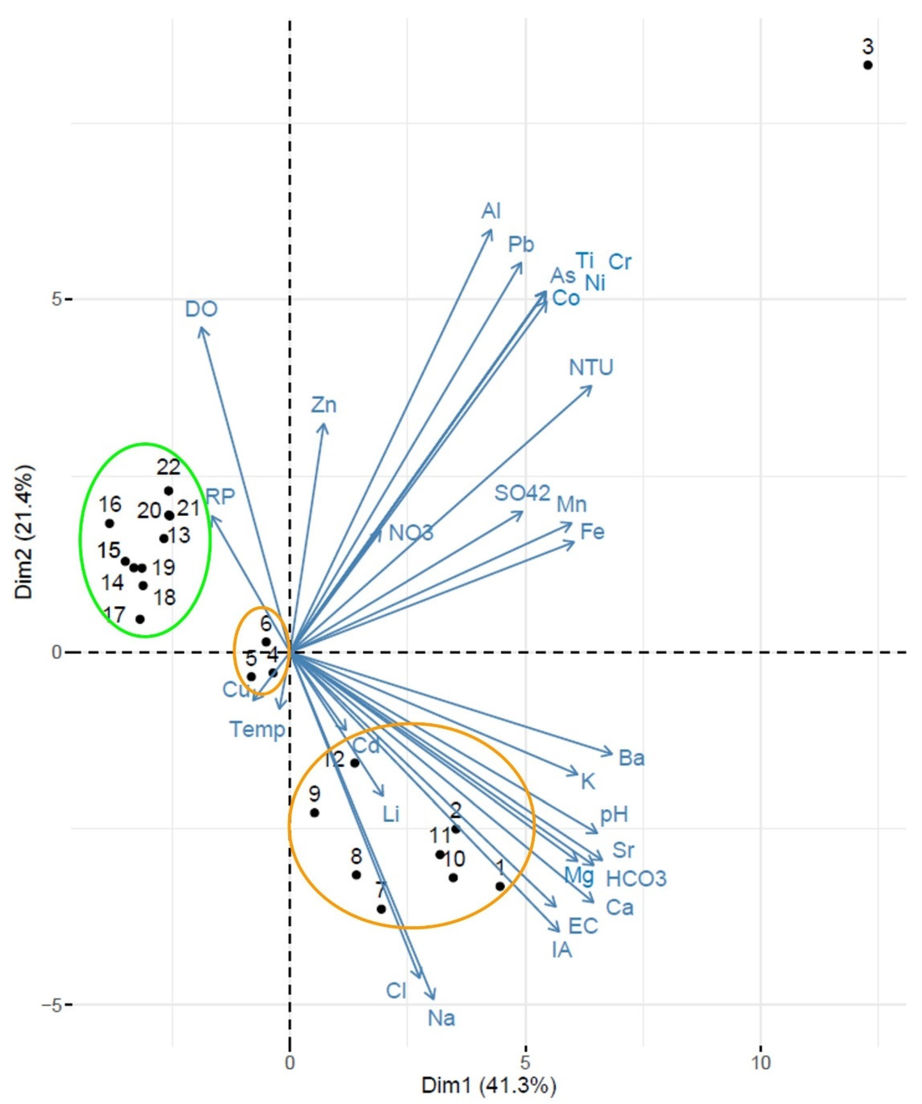
The PCA highlighted that there were differences between catchment types, with the first and second principal components reflecting approximately 63% of variance (PC1 41.3% and PC2 21.4%; see Supplementary data Tables S1–S3). Urban sites (1–3, 7–12) and naturally vegetated sites (numbered 13–22) showed distinct groups (Figure 4). The urban site at Wentworth Falls (numbered 4–6) was separate from the other three urban sites, being closer to the naturally vegetated sites. There was also consistency within sites over time. Impervious area (IA) showed an association with pH, electrical conductivity, calcium, magnesium, bicarbonate, strontium, potassium and barium (Figure 4).

3.2. Sediment Chemistry

3.2.1. Physical and Chemical Characterization of Sediment

All eight sediment cores can be broadly classified as having a peat/organic rich layer of 5–10 cm in depth overlaying clay or sandy-clay (see Supplementary data Figure S2). The peat/organic layers contained variable amounts of dark black (10YR 2/1) material primarily as decomposed detrital materials, mixed with more structured brown root material (5YR 3/2), which combines to the reported 10YR 2/2 for the majority of samples at 0–10 cm depths. Below this organic-rich layer, each core (excluding Hat Hill where the clay layer was lost during extraction due to suction) contained a dark brown (7.5YR 3/2) to black (10YR 2/1) fine clay layer with variable amounts of coarse, unsorted sand grains (up to 5%). There was limited evidence of redoximorphic features within the clay layers, which were field moist at the time of sampling but were not saturated.
There was no clear difference in pH and Eh between the catchment types (see Supplementary data Figure S2). Surface layer pH ranged from 5 to 6 pH units for the majority of cores, which is in line with the anticipated pH of water at equilibrium with atmospheric CO2 and humic acid. The exception was naturally vegetated Hat Hill, which was slightly more acidic at 4.31 pH units. Conversely, urban Lawson and Bullaburra had surface pH that was approaching neutral at 6.40 and 6.96 pH units, respectively. All sediment cores generally exhibited a decrease in pH (increasing acidity) between the organic/peat-rich surface materials and clay layer at depths (excluding Hat Hill). The Eh results also showed a decreasing trend with depth, with the highest readings within the surface layers and the lowest readings at depth. The mixing and exposure to atmospheric conditions within the surface layers are evident and persist through the peat layers that readily allow mixing with surface water. At depth, the permeability is lower due to the clay (and to a lesser extent sandy-clay), which would not readily facilitate mixing with oxygenated surface water conditions.

3.2.2. Mineralogy

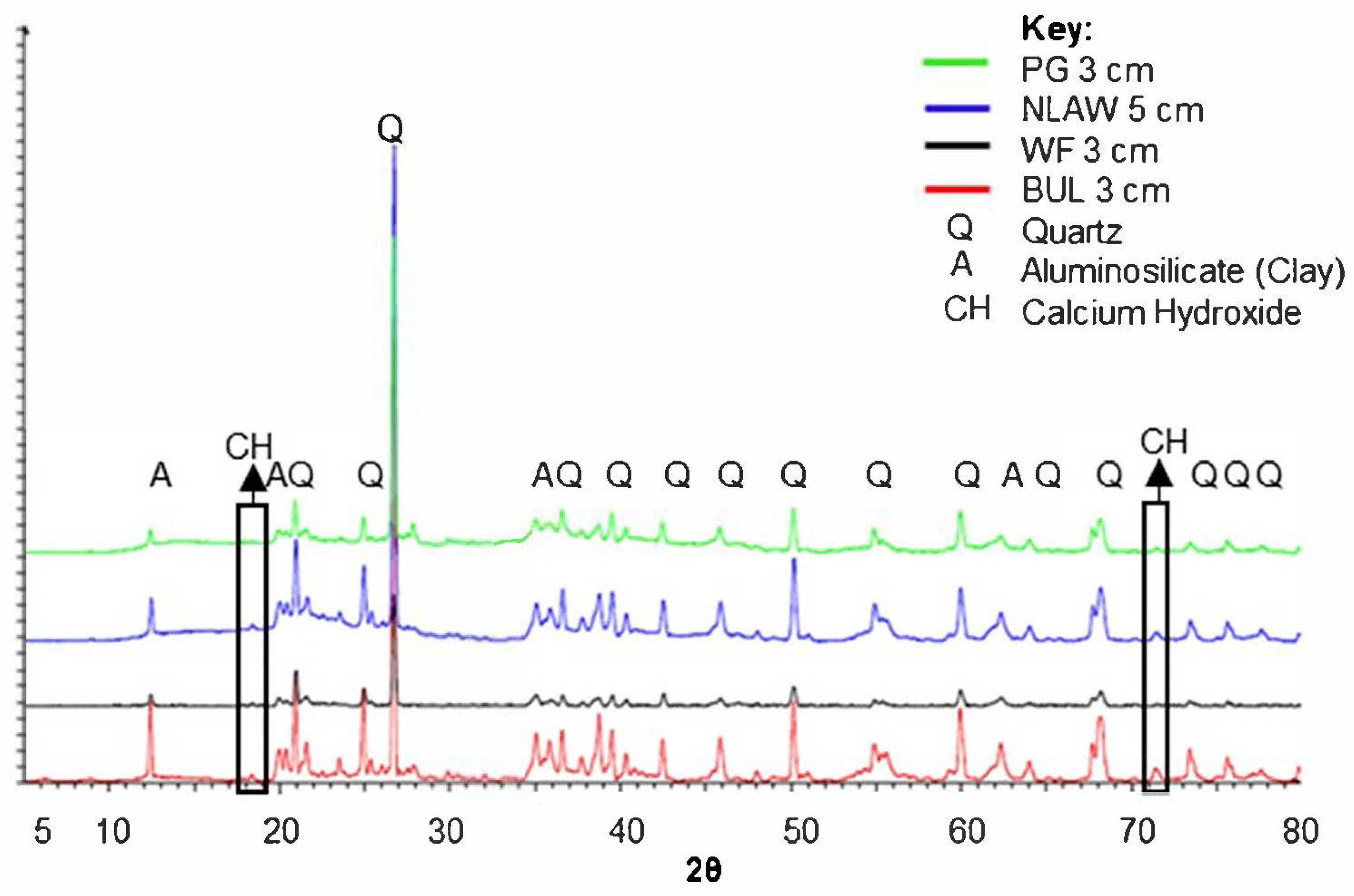
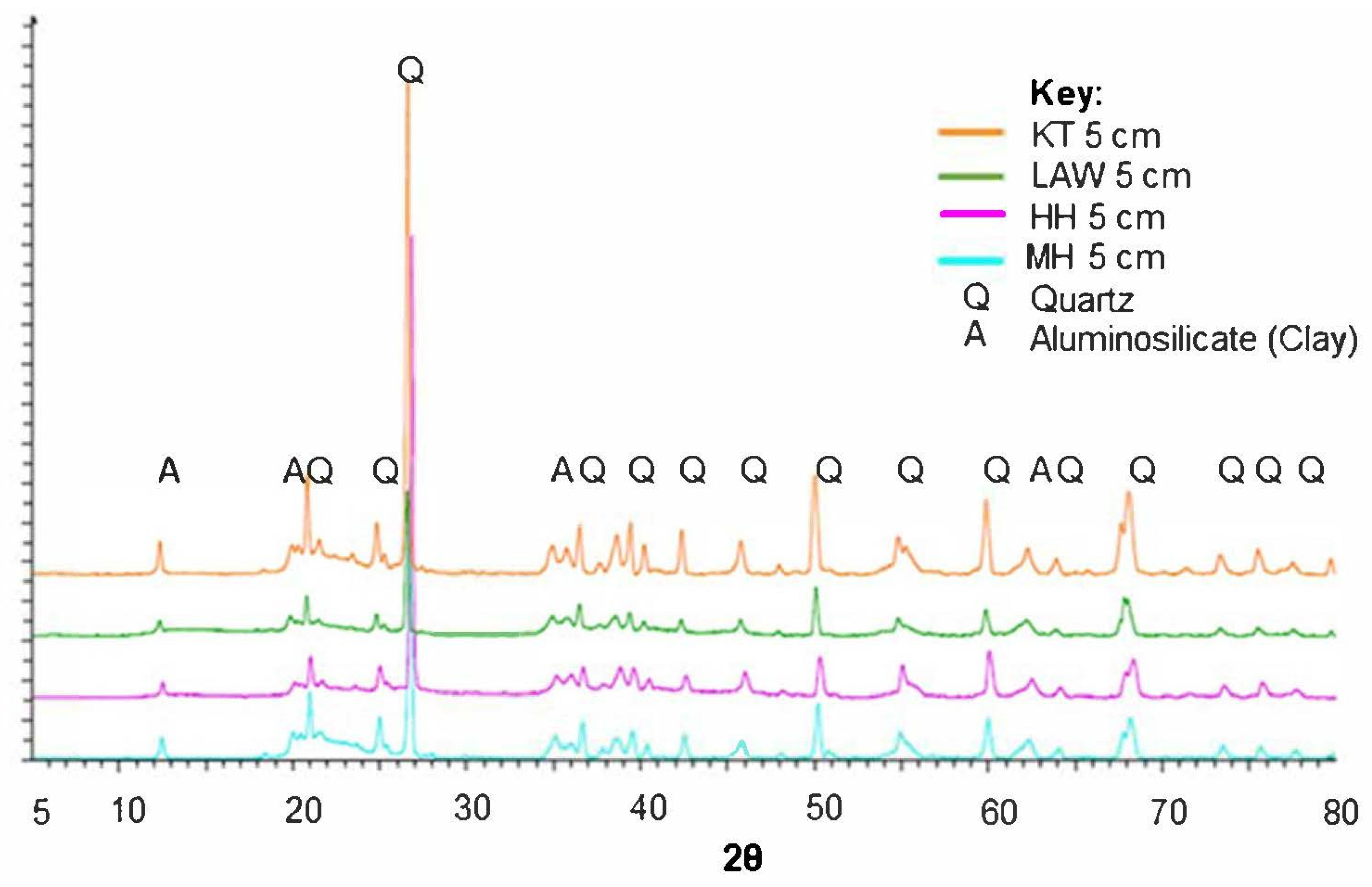
Surface sediment samples (top 3–5 cm) of the cores for all sites showed a mix of quartz, organics, and trace amounts of aluminosilicate materials. Multiple peaks throughout all samples show high crystallinity quartz, which is indicative of the dominant geology of the region, Hawkesbury sandstone (Figure 5 and Figure 6). Results suggested the presence of Ca(OH)2 in the surface sediment of two of the urban swamps, Bullaburra and Popes Glen, which was not present in any of the naturally vegetated swamps (Figure 5). This was particularly evident at 18 degrees 2θ and 71.5 degrees 2θ. However, the peaks for Ca(OH)2 were not clearly visible in the other two urban swamps (North Lawson and Wentworth Falls). There was also no clear evidence of CaCO3 in surface sediment from either catchment type (Figure 5 and Figure 6). It cannot be concluded that CaCO3 was not present (at a very low amount), due to the high crystallinity quartz in each sample, as this may have masked the presence of other elements and mineral structures. Spectra for surface samples from the naturally vegetated catchments remained consistent and did not exhibit any presence of Ca(OH)2 or CaCO3. Instead, all samples from the naturally vegetated THPSS were dominated by aluminosilicate materials (clay) and quartz (Figure 6).
There was variability in mineralogy by depth, as the surface layer of all cores contained more organic matter, resulting in the XRD samples being more amorphous, and quartz remained the dominant structure detected across all sites. A comparison by the depth of the two urban sites which exhibited the presence of Ca(OH)2 in the surface sediment (Bullaburra and Popes Glen) revealed that Ca(OH)2 was present at the positions of 18 degrees 2θ and 71.5 degrees 2θ throughout the soil profiles (see Supplementary data Figures S3 and S4). For the urban Bullaburra core, Ca(OH)2 exhibited the largest peak in the surface layer (3 cm) and this decreased with depth (see Supplementary data Figure S3). However, this trend was reversed in the urban Popes Glen core, with the largest peak for Ca(OH)2 observed in the deepest layer (19 cm) and decreasing in the higher layers (see Supplementary data Figure S4).
The Saturation Index (SI) for CaCO3 in the naturally vegetated swamps had a mean of 10−6.4 for all sites (Table 5). This low value observed in naturally vegetated THPSS suggests that CaCO3 is unlikely to be present as a precipitate in the sediment profile. However, the urban sites had higher and more variable CaCO3 SI values. Bullaburra (at 10−1.69) and Popes Glen (10−2.88) had values approaching equilibrium for CaCO3, suggesting that CaCO3 precipitation is more likely. North Lawson (10−3.23) and Wentworth Falls (10−4.66) also had higher SI values compared to the non-urban swamps, however to a lesser extent than Bullaburra and Popes Glen. Wentworth Falls did not appear to be as impacted as the other urban sites, with an SI value that was closer to those of the naturally vegetated catchments. The SI for Ca(OH)2 exhibited low values for all sites, which suggests the Ca(OH)2 is not thermodynamically favored, however values were slightly higher in the urban catchments (mean of 10−15 compared to 10−18.7 in the naturally vegetated catchments). Goethite (αFeOOH) values were positive, indicating that iron oxide precipitate is forming within the THPSS sites, and values were slightly higher in urban swamps due to elevated pH.

4. Discussion

The GBMA is a high conservation value region, however, urbanization and encroachment have the potential to place increasing pressure on fragile natural environments, such as THPSS, despite their legislative listings and heritage status. Findings from this study demonstrated that water in urban swamps had modified water chemistry, with elevated pH, EC, concentrations of major ions (particularly calcium and bicarbonate) and metals (including strontium, barium, manganese and iron) compared to non-urban catchments. The current study provides the first detailed examination yet conducted on THPSS mineralogy. This revealed that sediment from urban swamps had altered mineralogy, with a greater presence of calcium, particularly in the form of Ca(OH)2, compared to non-urban sites. This is in line with typical characteristics of urbanized catchments worldwide [8,10,13,53], previous findings from swamps within the GBMA [34,36,38], and patterns of evidence that strongly suggest that urban materials and impervious surfaces such as concrete remain a potential source of elevated calcium and alkalinity within sensitive freshwater systems [4,6,8]. However, this research is the first to investigate links between catchment urbanization, water chemistry and mineralogy of sediment within a sensitive freshwater wetland. The degree of modification identified within urban THPSS is lower relative to geochemical changes seen in other higher density urban catchments (such as [10,14,24]). However, findings are in line with concerns raised regarding the high threat of water pollution and urban development to the GBMA [30]. Whilst urban waterways typically have elevated nitrogen and phosphorus concentrations [2], this study revealed that nitrate and phosphate concentrations were not significantly enriched in urban THPSS. This study reinforces the potential impact that urbanization can have on fragile, acidic, dilute freshwater ecosystems, particularly in lands surrounding and within a recognized World Heritage Area. It is acknowledged that the study was conducted over a relatively short period of time and further longer-term studies are recommended.

4.1. Calcium and Urban Development

Calcium levels were elevated in urban swamp water and were associated with overall EC and greater ionic strength. This trend corresponds with global findings of higher calcium in urban waterways [7,10,24], and previous research within THPSS [34,40]. There is also evidence worldwide of elevated calcium in urban sediment profiles [12,13]. An increase in calcium concentrations of over 2000 times in urban riparian sediment (classified as >18% impervious area; mean 1184.96 mg kg−1) compared to non-urban catchments (<5% impervious area; mean 0.56 mg kg−1) was observed in the Georges River catchment in south-eastern Australia [14]. Findings from THPSS reflect this trend of elevated calcium, being almost 20 times greater in urban swamp water compared to non-urban sites, and highlights how sediment can act as a key sink for metals and alkalinity in urban catchments.
At the sediment-water interface, extensive research has examined the legacy of urbanization on sediment (such as in streams and wetlands), particularly in Europe (see [49]). The ratio of Ca: HCO3 predicted that precipitation of calcium phases was more likely in urban sediment. This was supported by the results of the mineralogical investigation, where trace levels of Ca(OH)2 were only observed to be present in two urban THPSS (Bullaburra and Popes Glen). Increased inputs of calcium and bicarbonate in urban catchments alters the equilibrium state and promotes CaCO3 precipitation. It is important to note that Ca(OH)2 is metastable in waters in equilibrium with atmospheric CO2 and ultimately CaCO3 will be formed. These reactions are mediated by acidity, alkalinity and the partial pressure of CO2. There were differences in the pH of BMUS sediment between catchment types, with surface sediment from naturally vegetated BMUS being more acidic (mean 5.2 pH units) than the urban swamps (mean 5.8 pH units).
The low natural background levels of calcium and alkalinity in regional geology, coupled with increasing encroachment of urban infrastructure within THPSS catchments [34,42], suggests that impervious materials such as concrete and urban stormwater infrastructure (including gutters and pipes) may contribute to increasing calcium above background concentrations within these systems, with the potential to accumulate in the sediment. This is further highlighted by the associations shown between impervious area and key elements such as calcium, bicarbonate and pH in Figure 4. The detection of Ca(OH)2 in sediment from two of the urban swamps is of interest, indicating the potential for urban modification within these poorly buffered systems, particularly as Ca(OH)2 is a common component of concrete. Calcium levels also decreased with depth, suggesting that calcium is not sourced from groundwater, but rather is coming from surface inputs, which could include urban runoff [7,24]. However, further research is required to characterize sources of elements, interactions between sediment and water, and the ecological implications of these sinks of nutrients is poorly understood in these ecosystems.

4.2. Altered Chemical Signature of Urban Ecosystems

Globally, it is recognized that aquatic ecosystems, including rivers, lakes and wetlands, with urban catchments exhibit altered elemental composition, elevated concentrations of metals, greater ionic strength and higher pH compared to background conditions [2,12,13,24,53,54,55,56]. This is supported by findings from this study, as urban THPSS demonstrated a modified ionic signature compared to naturally vegetated catchments. Whilst elemental loading still occurred, the signature of urban Wentworth Falls was more similar to the non-urban catchments despite having higher impervious cover (as shown in Figure 4), however, this may be impacted by interactions with the adjacent Wentworth Falls Lake. Findings from this study reflect the trends of previous water quality monitoring at this site [57,58,59]. Wentworth Falls Lake is an artificial impoundment which has resulted to partial flooding of areas of the swamp [60]. This may contribute to elevating the depth of the water table in unflooded sections of the swamp, thereby modifying natural hydrology. Additionally, Wentworth Falls Lake has also received upgrades to stormwater infrastructure, such as biofiltration systems, to reduce urban runoff into the swamp area [61]. This highlights the need for further research and monitoring to investigate the role of stormwater mitigation on improving water quality in swamp systems.
Elevated metals in water and sediment have previously been identified within urban areas [11,54,62,63]. This study builds on previous research to highlight that trace metals associated with urban development can accumulate in fragile, acidic and dilute wetlands. Iron, aluminium and manganese were dominant in THPSS, which is typical of undisturbed catchments in the Blue Mountains and reflect the influence of the sandstone geology [64] and ultimately the role of pH in regulating metal mobility. However, in urban swamp waters strontium and barium were significantly elevated compared to naturally vegetated catchments, whilst some trace metals (nickel, chromium, cobalt, arsenic and lithium) were only detected in urban swamps. Elevated strontium and barium have previously been associated with the weathering of urban materials, such as concrete and associated materials including fly ash [63,65,66,67,68]. These findings suggest that urban inputs may alter the elemental fingerprint of fragile freshwater ecosystems, however, the implications of elevated metals in these environments remain uncertain.
Contrary to global trends in urban waterways, nitrogen and phosphorus in water did not differ between catchment types [2,7,24,69]. The Blue Mountains region is naturally nutrient poor, however, highly urbanized waterways in the area have recorded nutrient enrichment [57,70]. Previous research by [71] suggested that ammonium was elevated in sediment in urban swamp catchments, however, found that nitrate levels were typically below detection methods across both urban and non-urban swamps, which reflects trends of this study. This suggests that elemental composition, along with pH and ionic strength, appear to be key factors driving differences between THPSS, not nutrient enrichment.

4.3. Relationships between Catchment Urbanization and Wetland Chemistry

There has been an increasing number of published studies making associations between the role of urban development, a high coverage of concrete surfaces in urban catchments and the modification of natural chemistry of water and sediment [4,6,7,10,24,53]. In particular, the dissolution of urban materials, such as concrete [25], poses a source of urban geochemical alteration for sensitive aquatic environments. Due to the global extent of urbanization and widespread documented sources of contamination such as stormwater runoff and weathering of urban materials, this has potential far-reaching implications for fragile, freshwater systems and the modification of natural wetland geochemistry. Findings from this study of THPSS suggest that urban swamps have elevated major anions, cations and trace metals in water, which can also accumulate in the sediment, and urban inputs are suspected as contributing to this modified elemental signature. Findings from the current study highlight the magnitude of the increased calcium content in both water and sediment of urban THPSS, compared to non-urban swamps. The current research also provides new insights into how the minerology of urban wetland sediment can act as a key sink for metals, calcium and other major ions. However, the ecological implications of this magnitude of change in water chemistry and accumulation within the sediment profile in fragile freshwater systems is not well-known.
Altering the chemical conditions of fragile freshwater wetlands may have significant implications for natural ecosystem functioning and biotic communities, such as leading to ecosystem shifts or weed invasions. This is a key suspected effect of urban geochemical modification of freshwater systems that requires further investigation. Urban runoff and stormwater are recognized to impact biotic communities through increased nutrient and pollutant levels, for example promoting weed species [72]. Weed invasion is recognized as a key threat within THPSS and the GBMA more broadly [29,30,35]. Recent research has suggested that modified physiochemical conditions, particularly elevated pH, in urban THPSS alters the abundance and composition of microbial communities, which has implications for nutrient cycling and decomposition rates [71]. The current study revealed that nitrogen and phosphorus concentrations were not significantly increased in urban THPSS, compared to non-urban swamps. This was in contrast to expectations, according to the global urban stream syndrome [2,3].
Links between catchment geological properties, chemical characteristics of the biotic community (such as aquatic plants), and urban land uses are increasingly being identified [73]. For example, [73] suggests that as carbon is a limiting factor for aquatic stream and lake vegetation, elevated bicarbonate concentrations (from geology and urban sources) can influence the distribution of species able to utilize bicarbonate under low CO2 conditions for photosynthesis, thereby altering community composition. This highlights how urban development within the catchments of sensitive freshwater systems can contribute to a shift in natural conditions, thereby potentially altering the composition of the vegetation and biotic community adapted to those conditions. This is of particular concern in regions such as the GBMA, as many endemic and endangered species are found within these specialized habitats.
Management of freshwater systems impacted by catchment urbanization can be complex. Remediation and strategies to improve swamp condition and water quality are possible [37], such as using revegetation and soft engineering works to manage stormwater runoff and limit channelization. This current research shows that further investigation into the legacy effects of urbanization in the sediment profile of wetlands would be beneficial. The current research also suggests that it is unlikely that urban swamps will return to a pre-urban state after they become degraded. The long-term implications of catchment urbanization requires further investigation. It would be highly desirable to study wetland water and sediment chemistry over a longer time period, including before versus after a wetland catchment is modified by urban development [74]. For example, research indicates that urban development is associated with modifying the natural geomorphology, hydrology and functioning of swamps, which can lead to desiccation, shifts in vegetation communities or modified biogeochemical cycles and carbon storage [33,38,39]. This raises questions as to how to better manage or protect vulnerable freshwater ecosystems, such as THPSS that occur on the fringe of an important World Heritage Area, in the face of increasing future population growth and urban development.

5. Conclusions

This current study demonstrates that catchment urbanization has the potential to substantially alter the natural geochemistry of freshwater environments. Urban THPSS had modified water chemistry, with elevated pH, altered ionic strength and composition and higher concentrations of several metals (including strontium and barium). Sediment from urban swamps displayed higher calcium and the presence of Ca(OH)2 was recorded at two of the urban swamps. These findings support previous research identifying that urban ecosystems exhibit altered water and sediment chemistry compared to non-urban catchments [8,14]. THPSS are poorly buffered, acidic, naturally dilute ecosystems that are vulnerable to degradation due to urban activities [34,36,37,38,39,40]. This study identifies novel interactions between water and sediment chemistry within a high-conservation value freshwater ecosystem, suggesting links between urban inputs, water chemistry and mineralogy of swamp sediments. It also highlights the potential for swamp sediments to be a sink for urban inputs, such as calcium, which may have long-lasting effects on the environment. However, the impact of urbanization on sediment is still poorly understood and further research is required to determine specific pathways and links between urban inputs, such as concrete sources, and the chemistry of urban freshwater environments. Further research should also investigate seasonal and multi-year studies. Urbanization is a global issue facing fragile, freshwater wetlands. Urban encroachment into natural ecosystems poses an increasing concern, particularly within a recognized World Heritage Area such as the GBMA which is at risk of further deterioration of conditions and biodiversity values. Examination of the water-sediment interface offers an important insight into changes to water chemistry and longer-term records within the sediment of urban inputs into sensitive freshwater systems. Lessons learnt from the effects of urban development on THPSS could be used to identify and target management strategies to better conserve these and other similar environments for the future.

Supplementary Materials

The following supporting information can be downloaded at: https://www.mdpi.com/article/10.3390/w14223724/s1; Figure S1: Electrical conductivity compared to (a). ionic strength (Moles; M) and (b). calcium (M); Figure S2: Summary of Redox (mV; indicated in green) and pH (pH units; indicated in blue) data for sediment cores from urban Temperate Highland Peat Swamps on Sandstone (THPSS) (a). Bullaburra, (b). Wentworth Falls, (c). North Lawson, (d). Popes Glen, and naturally vegetated THPSS catchments (e). Mount Hay, (f). Hat Hill, (g). Lawson and (h). Kings Tableland; Table S1: Eigenvalues for the Principal Component Analysis (PCA) conducted in R for the eight Temperate Highland Peat Swamps on Sandstone (THPSS) assessed in the Blue Mountains; Table S2: Summary of variables for the Principal Component Analysis (PCA) conducted in R for the eight Temperate Highland Peat Swamps on Sandstone (THPSS) assessed in the Blue Mountains; Table S3: Summary of individuals for the Principal Component Analysis (PCA) conducted in R for the eight Temperate Highland Peat Swamps on Sandstone (THPSS) assessed in the Blue Mountains; Figure S3: X-ray diffraction (XRD) spectra for sediment samples from the core collected from urban Bullaburra (BUL) Temperate Highland Peat Swamps on Sandstone (THPSS), where samples were collected at a depth of 3 cm (red), 10 cm (green) and 15 cm (blue); Figure S4: X-ray diffraction (XRD) spectra for sediment samples from the core collected from urban Popes Glen (PG) Temperate Highland Peat Swamps on Sandstone (THPSS), where samples were collected at a depth of 3 cm (light green), 10 cm (blue) and 19 cm (red).

Author Contributions

Conceptualization: R.C., J.K.R. and I.A.W.; methodology, R.C., J.K.R. and I.A.W.; formal analysis, R.C. and J.K.R.; writing—original draft preparation, R.C.; writing—review and editing, R.C., J.K.R. and I.A.W.; visualization, R.C.; supervision, J.K.R. and I.A.W. All authors have read and agreed to the published version of the manuscript.

Funding

The senior author conducted this research as part of a Master of Research degree using funding, equipment and facilities provided by Western Sydney University.

Data Availability Statement

Data supporting the findings of this study are available from the corresponding author upon email request.

Acknowledgments

We would like to acknowledge Richard Wuhrer and Laurel George from Advanced Materials Characterization Facility at Western Sydney University. Thank you to Michael Franklin, Sue Cusbert and Russell Thomson for their assistance with this project, and National Parks and Wildlife Service for permission to collect samples in the Blue Mountains National Park.

Conflicts of Interest

The authors declare no conflict of interest.

References

  1. Kaushal, S.S.; McDowell, W.H.; Wollheim, W.M. Tracking evolution of urban biogeochemical cycles: Past, present, and future. Biogeochemistry 2014, 121, 1–21. [Google Scholar] [CrossRef]
  2. Paul, M.J.; Meyer, J.L. Streams in the urban landscape. Ann. Rev. Ecol. Syst. 2001, 32, 333–365. [Google Scholar] [CrossRef]
  3. Walsh, C.J.; Roy, A.H.; Feminella, J.W.; Cottingham, P.D.; Groffman, P.M.; Morgan, R.P. The urban stream syndrome: Current knowledge and search for a cure. J. N. Am. Benthol. Soc. 2005, 24, 706–723. [Google Scholar] [CrossRef]
  4. Wright, I.A.; Davies, P.J.; Findlay, S.J.; Jonasson, O.J. A new type of water pollution: Concrete drainage infrastructure and geochemical contamination of urban waters. Mar. Freshw. Res. 2011, 62, 1355–1361. [Google Scholar] [CrossRef]
  5. Kaushal, S.S.; Likens, G.E.; Utz, R.M.; Pace, M.L.; Grese, M.; Yepsen, M. Increased river alkalinization in the eastern U.S. Environ. Sci. Technol. 2013, 47, 10302–10311. [Google Scholar] [CrossRef]
  6. Chambers, L.G.; Chin, Y.P.; Filippelli, G.M.; Gardner, C.B.; Herndon, E.M.; Long, D.T.; Lyons, W.B.; Macpherson, G.L.; McElmurry, S.P.; McLean, C.E.; et al. Developing the scientific framework for urban geochemistry. Appl. Geochem. 2016, 67, 1–20. [Google Scholar] [CrossRef]
  7. Moore, J.; Bird, D.L.; Dobbis, S.K.; Woodward, G. Nonpoint source contributions drive elevated major ion and dissolved inorganic carbon concentrations in urban watersheds. Environ. Sci. Technol. Let. 2017, 4, 198–204. [Google Scholar] [CrossRef]
  8. Kaushal, S.S.; Wood, K.L.; Galella, J.G.; Gion, A.M.; Haq, S.; Goodling, P.J.; Haviland, K.A.; Reimer, J.E.; Morel, C.J.; Wessel, B.; et al. Making ‘chemical cocktails’—Evolution of urban geochemical processes across the periodic table of elements. Appl. Geochem. 2020, 119, 104632. [Google Scholar] [CrossRef]
  9. Kaushal, S.S.; Likens, G.E.; Pace, M.L.; Reimer, J.E.; Maas, C.M.; Galella, J.G.; Utz, R.M.; Duan, S.; Kryger, J.R.; Yaculak, A.M.; et al. Freshwater salinization syndrome: From emerging global problem to managing risks. Biogeochemistry 2021, 154, 255–292. [Google Scholar] [CrossRef]
  10. MacAvoy, S.E.; Lunine, A. Anthropogenic influences on an urban river: Differences in cations and nutrients along an urban/suburban transect. Water 2022, 14, 1330. [Google Scholar] [CrossRef]
  11. Thornton, I. Metal contamination of soils in urban areas. In Soils in the Urban Environment; Bullock, P., Gregory, P.J., Eds.; Blackwell Scientific Publications: Oxford, UK, 1991; pp. 47–75. [Google Scholar]
  12. King, S.A.; Buckney, R.T. Invasion of exotic plants in nutrient-enriched urban bushland. Austral Ecol. 2002, 27, 573–583. [Google Scholar] [CrossRef]
  13. Bain, D.J.; Yesilonis, I.D.; Pouyat, R.V. Metal concentrations in urban riparian sediments along an urbanization gradient. Biogeochemistry 2012, 107, 67–79. [Google Scholar] [CrossRef]
  14. Grella, C.; Renshaw, A.; Wright, I.A. Invasive weeds in urban riparian zones: The influence of catchment imperviousness and soil chemistry across an urbanization gradient. Urban Ecosyst. 2018, 21, 505–517. [Google Scholar] [CrossRef]
  15. Poleto, C.; Charlesworth, S.; Laurenti, A. Urban aquatic sediments. In Sedimentology of Aqueous Systems; Poleto, C., Charlesworth, S., Eds.; Blackwell Publishing: Oxford, UK, 2010; pp. 129–146. [Google Scholar]
  16. Davies, J.; Charlesworth, S.M. Urbanization and stormwater. In Water Resources in the Built Environment: Management Issues and Solutions; Booth, C.A., Charlesworth, S.M., Eds.; Wiley-Blackwell: Oxford, UK, 2014; pp. 211–222. [Google Scholar]
  17. Macdonald, B.C.T.; Reynolds, J.K.; Kinsela, A.S.; Reilly, R.J.; van Oploo, P.; Waite, T.D.; White, I. Critical coagulation in sulfidic sediments from an east-coast Australian acid sulfate landscape. Appl. Clay Sci. 2009, 46, 166–175. [Google Scholar] [CrossRef]
  18. Åström, M.E.; Nystrand, M.; Gustafsson, J.P.; Österholm, P.; Nordmyr, L.; Reynolds, J.K.; Peltola, P. Lanthanoid behaviour in an acidic landscape. Geochim. Cosmochim. Acta 2010, 74, 829–845. [Google Scholar] [CrossRef]
  19. Åström, M.E.; Yu, C.; Peltola, P.; Reynolds, J.K.; Österholm, P.; Nystrand, M.I.; Augustsson, A.; Virtasalo, J.J.; Nordmyr, L.; Ojala, A.E. Sources, transport and sinks of beryllium in a coastal landscape affected by acidic soils. Geochim. Cosmochim. Acta 2018, 232, 288–302. [Google Scholar] [CrossRef]
  20. Fiałkiewicz-Kozieł, B.; De Vleeschouwer, F.; Mattielli, N.; Fagel, N.; Palowski, B.; Pazdur, A.; Smieja-Król, B. Record of Anthropocene pollution sources of lead in disturbed peatlands from Southern Poland. Atmos. Environ. 2018, 179, 61–68. [Google Scholar] [CrossRef]
  21. Davies, P.J.; Wright, I.A.; Jonasson, O.J.; Findlay, S.J. Impact of concrete and PVC pipes on urban water chemistry. Urban Water J. 2010, 7, 233–241. [Google Scholar] [CrossRef]
  22. Grella, C.; Wright, I.A.; Findlay, S.J.; Jonasson, O.J. Geochemical contamination of urban water by concrete stormwater infrastructure: Applying an epoxy resin coating as a control treatment. Urban Water J. 2016, 13, 212–219. [Google Scholar] [CrossRef]
  23. Borris, M.; Österlund, H.; Marsalek, J.; Viklander, M. An exploratory study of the effects of stormwater pipeline materials on transported stormwater quality. Water Sci. Technol. 2017, 76, 247–255. [Google Scholar] [CrossRef]
  24. Kaushal, S.S.; Duan, S.; Doody, T.R.; Haq, S.; Smith, R.M.; Newcomer Johnson, T.A.; Newcomb, K.D.; Gorman, J.; Bowman, N.; Mayer, P.M.; et al. Human-accelerated weathering increases salinization, major ions, and alkalinization in fresh water across land use. Appl. Geochem. 2017, 83, 121–135. [Google Scholar] [CrossRef] [PubMed]
  25. Wright, I.A.; Khoury, R.; Ryan, M.M.; Belmer, N.; Reynolds, J.K. Laboratory study of impacts of concrete fragment sizes on wetland water chemistry. Urban Water J. 2018, 15, 61–67. [Google Scholar] [CrossRef]
  26. Cannon, W.F.; Horton, J.D. Soil geochemical signature of urbanization and industrialization—Chicago, Illinois, USA. Appl. Geochem. 2009, 24, 1590–1601. [Google Scholar] [CrossRef]
  27. New South Wales National Parks and Wildlife Service. The Greater Blue Mountains Area World Heritage Nomination. Available online: https://www.environment.gov.au/system/files/pages/50d276f9-337f-4d9f-85f5-120ded99fc85/files/gbm-nomination.pdf (accessed on 12 November 2020).
  28. United Nations Educational, Scientific and Cultural Organization. Greater Blue Mountains Area. Available online: https://whc.unesco.org/en/list/917 (accessed on 20 August 2019).
  29. Department of Agriculture, Water and the Environment. State Party Report on the State of Conservation of the Greater Blue Mountains Area World Heritage Property (Australia). Available online: https://www.environment.gov.au/system/files/resources/ef7799c2-866e-4dc8-8a87-3a0066124183/files/state-party-report-state-conservation-greater-blue-mountains-area-world-heritage-property.pdf (accessed on 28 September 2021).
  30. International Union for Conservation of Nature. Greater Blue Mountains Area 2020 Conservation Outlook Assessment. Available online: https://worldheritageoutlook.iucn.org/explore-sites/wdpaid/220294 (accessed on 6 December 2020).
  31. New South Wales National Parks and Wildlife Service. Greater Blue Mountains World Heritage Area Strategic Plan. Available online: https://www.environment.nsw.gov.au/-/media/OEH/Corporate-Site/Documents/Parks-reserves-and-protected-areas/Parks-plans-of-management/greater-blue-mountains-world-heritage-area-strategic-plan-080491.pdf (accessed on 28 September 2021).
  32. Blue Mountains City Council. Local Government Area. Available online: http://bmcc.nsw.goc.au/council/councillors-and-elections/local-governmnet-area (accessed on 11 November 2020).
  33. Fryirs, K.; Freidman, B.; Williams, R.; Jacobsen, G. Peatlands in eastern Australia? Sedimentology and age structure of Temperate Highland Peat Swamps on Sandstone (THPSS) in the Southern Highlands and Blue Mountains of NSW, Australia. Holocene 2014, 24, 1527–1538. [Google Scholar] [CrossRef]
  34. Belmer, N.; Wright, I.A.; Tippler, C. Urban geochemical contamination of high conservation value upland swamps, Blue Mountains, Australia. Water Air Soil Pollut. 2015, 226, 332–337. [Google Scholar] [CrossRef]
  35. Department of Agriculture, Water and the Environment. Temperate Highland Peat Swamps on Sandstone. Available online: http://www.environment.gov.au/node/14561 (accessed on 12 November 2020).
  36. Belmer, N.; Tippler, C.; Wright, I.A. Aquatic ecosystem degradation of high conservation value upland swamps, Blue Mountains Australia. Water Air Soil Pollut. 2018, 229, 98. [Google Scholar] [CrossRef]
  37. Hensen, M.; Mahony, E. Reversing drivers of degradation in Blue Mountains and Newnes Plateau Shrub Swamp endangered ecological communities. Australas. Plant Conserv. J. Aust. Netw. Plant Conserv. 2010, 18, 5–6. [Google Scholar]
  38. Cowley, K.L.; Fryirs, K.A.; Hose, G.C. Identifying key sedimentary indicators of geomorphic structure and function of upland swamps in the Blue Mountains for use in condition assessment and monitoring. Catena 2016, 147, 564–577. [Google Scholar] [CrossRef]
  39. Cowley, K.L.; Fryirs, K.A. Forgotten peatlands of eastern Australia: An unaccounted carbon capture and storage system. Sci. Total Environ. 2020, 730, 139067. [Google Scholar] [CrossRef]
  40. Carroll, R.; Reynolds, J.K.; Wright, I.A. Geochemical signature of urbanization in Blue Mountains Upland Swamps. Sci. Total Environ. 2020, 699, 134393. [Google Scholar] [CrossRef]
  41. van der Beek, P.; Pulford, A. Cenozoic landscape development in the Blue Mountains (SE Australia): Lithological and tectonic. J. Geol. 2001, 109, 35–56. [Google Scholar] [CrossRef]
  42. Pickett, J. Layers of time: The Blue Mountains and their geology. In Blue Mountains and Their Geology; Alder, J.D., Ed.; Geological Survey of New South Wales: Sydney, Australia, 2011. [Google Scholar]
  43. Mooney, S.; Martin, L. The unique and surprising environments of Temperate Highland Peat Swamps on Sandstone (THPSS) in the Blue Mountains, NSW. Australas. Plant Conserv. J. Aust. Netw. Plant Conserv. 2016, 24, 18–22. [Google Scholar]
  44. Bureau of Meteorology. Monthly Climate Statistics for Australian Locations—Summary Statistics for Katoomba (Farnells Rd). Available online: http://www.bom.gov.au/climate/averages/tables/cw_063039.shtml (accessed on 20 August 2019).
  45. United States Environmental Protection Agency. Estimating Change in Impervious Area (IA) and Directly Connected Impervious Areas (DCIA) for New Hampshire Small MS4 Permit; Small MS4 Permit Technical Support Document, April 2011; National Service Centre for Environmental Publications: Cincinnati, OH, USA, 2011. [Google Scholar]
  46. Department of the Environment. Australia World Heritage Areas. Available online: https://data.gov.au/dataset/ds-dga-83191acf-287d-4acf-86dc-b3caa15bf97f/distribution/dist-dga-430602f0-0f54-4ff7-840f-120c50c3d93a/details?q= (accessed on 12 November 2020).
  47. American Public Health Association. Standard Methods for the Examination of Water and Wastewater, 22nd ed.; American Public Health Association: Washington, DC, USA, 2012. [Google Scholar]
  48. Bruker. DIFFRAC.SUITE User Manual: DIFFRAC.EVALUATION Package; DIFFRAC.EVA: Karlsruhe, Germany, 2011. [Google Scholar]
  49. Johnson, C.C.; Demetriades, A.; Locutura, J.; Tore Ottesen, R. (Eds.) Mapping the Chemical Environment of Urban Areas; John Wiley & Sons Ltd: Chichester, UK, 2011. [Google Scholar]
  50. Lȇ, S.; Josse, J.; Husson, F. FactoMineR: An R package for multivariate analysis. J. Stat. Softw. 2008, 25, 1–18. [Google Scholar] [CrossRef] [Green Version]
  51. R Core Team. R: A Language and Environment for Statistical Computing; R Foundation for Statistical Computing: Vienna, Austria, 2021. [Google Scholar]
  52. Parkhurst, D.L.; Appelo, C.A.J. Description of Input and Examples for PHREEQC Version 3—A Computer Program for Speciation, Batch-Reaction, One-Dimensional Transport, and Inverse Geochemical Calculations; U.S. Geological Survey Techniques and Methods; U.S. Department of the Interior and U.S. Geological Survey: Denver, CO, USA, 2013; Book 6, Chapter A43; p. 497. [Google Scholar]
  53. Tippler, C.; Wright, I.A.; Davies, P.J.; Hanlon, A. The influence of concrete on the geochemical qualities of urban streams. Mar. Freshw. Res. 2014, 65, 1009–1017. [Google Scholar] [CrossRef]
  54. Rate, A.W. Multielement geochemistry identifies the spatial pattern of soil and sediment contamination in an urban parkland, Western Australia. Sci. Total Environ. 2018, 627, 1106–1120. [Google Scholar] [CrossRef]
  55. Machowksi, R.; Rzetala, M.A.; Rzetala, M.; Maksymilian, S. Anthropogenic enrichment of the chemical composition of bottom sediments of water bodies in the neighborhood of a non-ferrous metal smelter (Silesian Upland, Southern Poland). Nature 2019, 9, 14445. [Google Scholar] [CrossRef] [Green Version]
  56. Stets, E.G.; Sprague, L.A.; Oelsner, G.P.; Johnson, H.M.; Murphy, J.C.; Ryberg, K.; Vecchia, A.V.; Zuellig, R.E.; Falcone, J.A.; Riskin, M.L. Landscape drivers of dynamic change in water quality of U.S. rivers. Environ. Sci. Technol. 2020, 54, 4336–4343. [Google Scholar] [CrossRef]
  57. Blue Mountains City Council. Blue Mountains Waterways Health Report 2017; Blue Mountains City Council: Katoomba, Australia, 2007. [Google Scholar]
  58. Blue Mountains City Council. Blue Mountains Waterways 2019 Interim Health Report. Available online: https://www.bmcc.nsw.gov.au/documents/2019-blue-mountains-waterways-health-report (accessed on 15 December 2020).
  59. Blue Mountains City Council. Assessment of Potential Recreational Swimming Locations in the Blue Mountains City Council Local Government Area. Available online: https://www.bmcc.nsw.gov.au/sites/default/files/docs/Water%20quality%20assessment%20of%20potential%20recreational%20swimming%20locations%20-%20Blue%20Mountains%20City%20Council%20-%20updated%20Sep%202020.pdf (accessed on 15 December 2020).
  60. Office of Environment & Heritage. Wf021: Wentworth Falls Lake. Available online: https://www.environment.nsw.gov.au/heritageapp/ViewHeritageItemDetails.aspx?ID=1170639 (accessed on 7 December 2020).
  61. Blue Mountains City Council. Wentworth Falls Lake Reserve Plan of Management. Available online: https://www.bmcc.nsw.gov.au/sites/default/files/docs/2021-06-29_Enclosure_Item12_Part1.pdf (accessed on 20 October 2021).
  62. Pouyat, R.V.; McDonnell, M.J. Heavy metal accumulations in forest soils along an urban-rural gradient in southeastern New York, USA. Water Air Soil Pollut. 1991, 57–58, 797–807. [Google Scholar] [CrossRef]
  63. Connor, N.P.; Sarraino, S.; Frantz, D.E.; Bushaw-Newton, K.; Macavoy, S.E. Geochemical characteristics of an urban river: Influences of an anthropogenic landscape. Appl. Geochem. 2014, 47, 209–216. [Google Scholar] [CrossRef]
  64. Price, P.; Wright, I.A. Water quality impact from the discharge of coal mine wastes to receiving streams: Comparison of impacts from an active mine with a closed mine. Water Air Soil Pollut. 2016, 227, 155. [Google Scholar] [CrossRef]
  65. Graham, I.J.; Goguel, R.L.; St John, D.A. Use of strontium isotopes to determine the origin of cement in concretes: Case examples from New Zealand. Cem. Concr. Res. 2000, 30, 1105–1111. [Google Scholar] [CrossRef]
  66. Christian, L.N.; Banner, J.L.; Mack, L.E. Sr isotopes as tracers of anthropogenic influences on stream water in the Austin, Texas, area. Chem. Geol. 2011, 282, 84–97. [Google Scholar] [CrossRef]
  67. Müllauer, W.; Beddoe, R.E.; Heinz, D. Leaching behavior of major and trace elements from concrete: Effect of fly ash and GGBS. Cem. Concr. Compos. 2015, 58, 129–139. [Google Scholar] [CrossRef]
  68. Vollpracht, A.; Brameshuber, W. Binding and leaching of trace elements in Portland cement pastes. Cem. Concr. Res. 2016, 79, 76–92. [Google Scholar] [CrossRef]
  69. Hogan, D.M.; Walbridge, M.R. Urbanization and nutrient retention in freshwater wetlands. Ecol. Appl. 2007, 17, 1142–1155. [Google Scholar] [CrossRef]
  70. Wright, I.A.; Burgin, S. Comparison of sewage and coal-mine wastes on stream macroinvertebrates within an otherwise clean upland catchment, southeastern Australia. Water Air Soil Pollut. 2009, 204, 227. [Google Scholar] [CrossRef]
  71. Christiansen, N.A.; Fryirs, K.A.; Green, T.J.; Hose, G.C. The impact of urbanization on community structure, gene abundance and transcription rates in microbes of upland swamps of Eastern Australia. PLoS ONE 2019, 14, e0213275. [Google Scholar] [CrossRef] [Green Version]
  72. Leishman, M.R.; Hughes, M.T.; Gore, D.B. Soil phosphorus enhancement below stormwater outlets in urban bushland: Spatial and temporal changes and the relationship with invasive plants. Aust. J. Soil Res. 2004, 42, 197–202. [Google Scholar] [CrossRef]
  73. Iversen, L.L.; Winkel, A.; Baastrup-Sphor, L.; Hinke, A.B.; Alahuhta, J.; Baattrup-Pedersen, A.; Birk, S.; Brodersen, P.; Chambers, P.A.; Ecke, F.; et al. Catchment properties and the photosynthetic trait composition of freshwater plant communities. Science 2019, 366, 878–881. [Google Scholar] [CrossRef]
  74. Underwood, A.J. On Beyond BACI: Sampling Designs that Might Reliably Detect Environmental Disturbances. Ecol. Appl. 1994, 4, 3–15. [Google Scholar] [CrossRef]
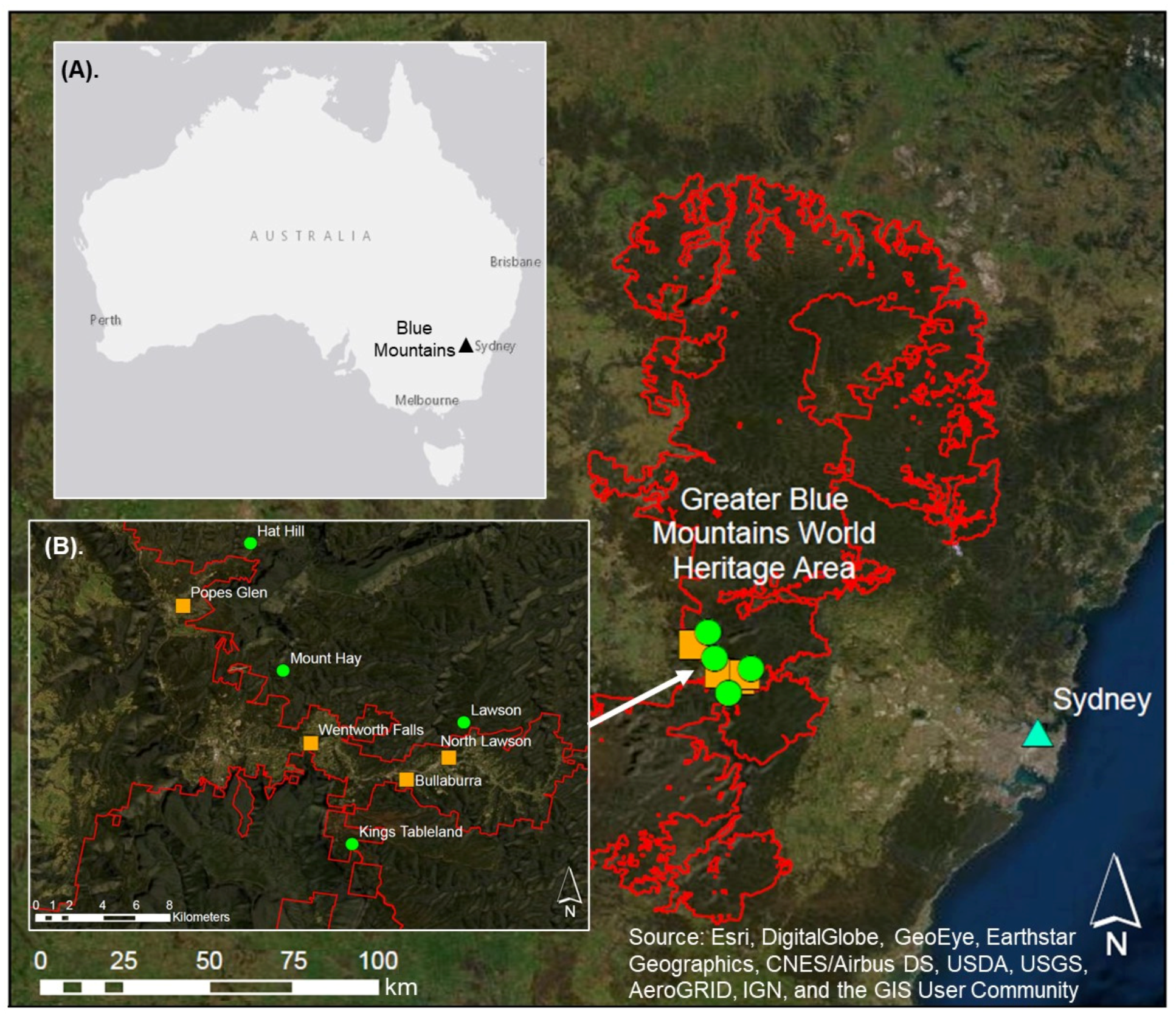
Figure 1. The location of the study region in the Blue Mountains (inset (A)), west of Sydney (blue triangle), NSW, Australia, with the boundary of the Greater Blue Mountains World Heritage Area shown in red [46]; Creative Commons Attribution 4.0]. Inset (B) outlines the Temperate Highland Peat Swamps on Sandstone (THPSS) sites, including urban (orange squares) and naturally vegetated (green circles) THPSS catchments.
Water 14 03724 g001
Figure 2. Comparison of the mean (+/− standard error) ionic signature of water in urban (n = 4) and naturally vegetated (n = 4) Temperate Highland Peat Swamps on Sandstone (THPSS) catchments from April to June 2018, including (A) major cations and (B) major anions.
Water 14 03724 g002
Figure 3. Comparison of mean (+/− standard error) concentrations of statistically significant metals in water between urban (n = 4) and naturally vegetated (n = 4) Temperate Highland Peat Swamps on Sandstone (THPSS) catchments over the course of the study (April–June 2018).
Water 14 03724 g003
Figure 4. Principal Components Analysis (PCA) of water quality parameters and impervious area from four urban (outlined in orange) and four naturally vegetated (outlined in green) Temperate Highland Peat Swamps on Sandstone (THPSS) from April–June 2018 (excluding Mount Hay). Sites are numbered as urban Bullaburra (1–3), Wentworth Falls (4–6), North Lawson (7–9), and Popes Glen (10–12), and naturally vegetated Mount Hay (13), Hat Hill (14–16), Lawson (17–19), and Kings Tableland (20–22). Variables are indicated as impervious area (IA), pH, electrical conductivity (EC), dissolved oxygen (DO), temperature (Temp), turbidity (NTU), nitrates (NO3), reactive phosphates (RP), calcium (Ca), bicarbonate alkalinity as CaCO3 (referred to as HCO3), magnesium (Mg), potassium (K), aluminium (Al), strontium (Sr), barium (Ba), iron (Fe), manganese (Mn), sulfate (SO42), cobalt (Co), arsenic (As), nickel (Ni), chromium (Cr), titanium (Ti), lead (Pb), zinc (Zn), copper (Cu), cadmium (Cd) and lithium (Li).
Water 14 03724 g004
Figure 5. XRD spectra for surface sediment samples (0–5 cm) from urban (n = 4) Temperate Highland Peat Swamps on Sandstone (THPSS) catchments (from 5–80 degrees 2θ). Sites are indicated as Bullaburra (BUL; red), Wentworth Falls (WF; black), North Lawson (NLAW; dark blue) and Popes Glen (PG; light green). The y axis refers to intensity. Quartz is indicated as Q, aluminosilicate as A and calcium hydroxide as CH. Peaks at 18 degrees 2θ and 71.5 degrees 2θ are indicative of calcium hydroxide.
Water 14 03724 g005
Figure 6. XRD spectra for surface sediment samples (0–5 cm) from naturally vegetated (n = 4) Temperate Highland Peat Swamps on Sandstone (THPSS) catchments (from 5–80 degrees 2θ). Sites are indicated as Mount Hay (MH; light blue), Hat Hill (HH; pink), Lawson (LAW; dark green) and Kings Tableland (KT; orange). The y axis refers to intensity. Quartz is indicated as Q and aluminosilicate as A.
Water 14 03724 g006
Table 1. The location and details of the eight Temperate Highland Peat Swamps on Sandstone (THPSS) study sites from which water and sediment were collected.
Swamp NameCatchment TypeLatitude and
Longitude
Elevation above Sea Level at Sampling Location (m)Swamp Area (ha)Total
Impervious Area within Catchment (IA%)
Percentage Directly
Connected Impervious Area (DCIA%)
(1). BullaburraUrban−33.727319, 150.4129287550.6825.039.54
(2). Wentworth FallsUrban−33.707627, 150.3613138809.9322.417.90
(3). North LawsonUrban−33.713851, 150.4271956951.1523.158.35
(4). Popes GlenUrban−33.633639, 150.29233610100.8234.3016.30
(5). Mt HayNaturally
vegetated
−33.668644, 150.3465089203.920.000.00
(6). Hat HillNaturally
vegetated
−33.599941, 150.3287829674.100.000.00
(7). LawsonNaturally
vegetated
−33.696739, 150.4440276659.100.000.00
(8). Kings TablelandNaturally
vegetated
−33.76210, 150.383737806.060.180.002
Table 2. Summary of water physiochemical properties for Temperate Highland Peat Swamps on Sandstone (THPSS) in urban (n = 4) and naturally vegetated (n = 4) catchments from April-June 2018 sampling.
AttributesF Statisticd.fp ValueUrban CatchmentsNaturally Vegetated Catchments
RangeMeanMedianRangeMeanMedian
pH50.381, 200.000 **5.56–7.096.206.084.56–5.404.874.81
Electrical Conductivity (µS cm−1)18.801, 190.000 **45.10–169.90116.30137.4525.30–79.1045.5749.70
Dissolved Oxygen (% saturation)11.981, 200.002 *3.20–91.4051.5250.0575.00–102.5085.0283.45
Temperature (°C)0.511, 18.010.483 (ns)6.60–16.9010.598.956.20–24.7011.859.40
Turbidity (NTU)2.921, 20 0.103 (ns)1.57–88.5013.527.040.73–19.803.002.18
Nitrates (mg L−1 NO3-)0.021, 18.120.890 (ns)0.10–0.800.380.400.00–1.100.370.35
Reactive Phosphates (mg L−1 PO43-)1.711, 18.010.207 (ns)0.02–1.350.270.200.04–2.390.320.20
Notes: Significance is indicated as * = p< 0.01, ** = p < 0.001 and ns = not significant. d.f. denotes the degrees of freedom (numerator, denominator).
Table 3. Summary of water chemistry results from urban and non-urban Temperate Highland Peat Swamps on Sandstone (THPSS) between April–June 2018.
Major IonsF Statisticd.f.p ValueUrban CatchmentsNaturally Vegetated Catchments
RangeMeanMedianRangeMeanMedian
Calcium61.721, 420.000 **2.10–20.0010.9012.000.25 ˟–1.300.550.25
Potassium24.291, 420.000 **0.25 ˟–2.801.290.900.25 ˟0.25 ˟0.25 ˟
Sodium16.541, 40.250.00 **4.80–13.008.197.554.00–7.405.876.00
Magnesium46.741, 40.390.00 **0.60–1.901.231.200.25 ˟–0.800.540.70
Bicarbonate Alkalinity as CaCO342.861, 40.350.000 **5.00–56.0025.6722.500.002.50 ˟2.50 ˟
Sulfate6.731, 40.170.013 *0.5 ˟–11.004.463.000.5 ˟–6.002.401.00
Chloride16.691, 420.000 **6.00–36.0016.7414.006.00–11.008.629.00
Calculated Ionic Strength (M)---0.0005–0.00200.00150.00160.0002–0.00060.00040.0004
Ratio Ca:HCO3----0.75:1–1.4:11:10.95:10.3:1–1:11:20.3:1
Notes: Significance is indicated as * = p < 0.05, ** = p < 0.001. Data is presented as mg L−1, unless otherwise specified. ˟ denotes values that were below the detection limit. d.f. refers to degrees of freedom (numerator, denominator) and—indicates that statistical analysis was not required for the attribute. Units for ionic strength are in Moles (M).
Table 4. Summary of metals in water between urban (n = 4) and naturally vegetated (n = 4) Temperate Highland Peat Swamps on Sandstone (THPSS) catchment types (mean from the three sampling events).
Major ionsF Statisticd.f.p ValueUrban CatchmentsNaturally Vegetated Catchments
RangeMeanMedianRangeMeanMedian
Aluminium0.061, 40.140.81 (ns)5 ˟–1200.00214.4470.0080.00–290.00159.55120.00
Manganese7.571, 420.009 *2.5 ˟–260.0068.9317.002.5 ˟–31.009.959.00
Iron15.401, 40.130.00 **250.00–7100.002288.151300.0058.00–630.00281.73270.00
Nickel1.731, 420.20 (ns)0.5 ˟–1.000.560.500.5 ˟0.5 ˟0.5 ˟
Zinc2.631, 420.11 (ns)0.5 ˟–25.008.706.000.5 ˟–34.0013.146.50
Barium27.731, 420.00 **3.00–36.0018.6318.004.00–9.005.775.00
Cadmium0.471, 40.130.50 (ns)0.05 ˟–48.003.640.300.05 ˟–22.001.930.35
Chromium1.731, 40.140.20 (ns)0.5 ˟–2.000.670.500.5 ˟0.5 ˟0.5 ˟
Lead0.741, 40.410.40 (ns)0.5 ˟–8.001.370.500.5 ˟–2.000.750.50
Strontium55.841, 40.130.00 **11.00–75.0037.2638.001.40–7.903.852.65
Cobalt1.731, 40.0100.20 (ns)0.5 ˟–2.000.670.500.5 ˟0.5 ˟0.5 ˟
Copper0.181, 40.130.6740.5 ˟–94.0015.173.000.5 ˟–60.0017.003.50
Arsenic1.731, 40.25(ns)0.5 ˟–3.000.780.500.5 ˟0.5 ˟0.5 ˟
Lithium2.041, 40.110.20 (ns)0.5 ˟–1.000.540.500.5 ˟0.5 ˟0.5 ˟
Titanium2.301, 40.130.16 (ns)0.5 ˟–12.001.960.500.5 ˟–1.700.620.50
Notes: Significance is indicated as * = p< 0.01, ** = p < 0.001 and ns = not significant. Data is presented as µg L−1. ˟ denotes values that were below the detection limit. d.f. denotes the degrees of freedom (numerator, denominator).
Table 5. Saturation Index (SI) in log for calcite (CaCO3), portlandite (Ca(OH)2) and goethite (αFeOOH) in water from urban (n = 4) and naturally vegetated (n = 4) Temperate Highland Peat Swamps on Sandstone (THPSS) catchments.
Swamp NameCatchment TypeLog SI
CaCO3Ca(OH)2αFeOOH
(1). BullaburraUrban−1.69−12.946.66
(2). Wentworth FallsUrban−4.66−16.705.54
(3). North LawsonUrban−3.23−15.285.69
(4). Popes GlenUrban−2.88−15.136.21
(5). Mt HayNaturally vegetated−6.46−17.895.06
(6). Hat HillNaturally vegetated−6.57−18.834.37
(7). LawsonNaturally vegetated−6.38−19.173.79
(8). Kings TablelandNaturally vegetated−6.20−19.023.91
Publisher’s Note: MDPI stays neutral with regard to jurisdictional claims in published maps and institutional affiliations.