Article

Agricultural Productive Carrying Capacity Improve and Water Optimal Allocation under Uncertainty Based on Remote Sensing Data in Lancang County, Southwest China

Center for Agricultural Water Research in China, China Agricultural University, Beijing 100083, China
*
Author to whom correspondence should be addressed.
Water 2022, 14(22), 3641; https://doi.org/10.3390/w14223641
Submission received: 27 August 2022 / Revised: 19 September 2022 / Accepted: 22 September 2022 / Published: 11 November 2022
(This article belongs to the Special Issue Numerical Modeling of Water Flow, Nutrients and Sediment Transport)

Abstract

:
Through the reasonable calculation of water resources, evaluating the irrigation carrying capacity of farmland under the constraints of water resources is crucial for optimizing the spatial distribution of agricultural production and ecology and rationally adjusting the scale of agricultural production. This paper proposes an optimization framework based on Type 2 fuzzy chance-constrained programming (T2FCCP) to solve the problem of regional water resources optimal allocation and evaluation of farmland irrigation carrying capacity under uncertain conditions. To illustrate the applicability of the proposed framework, this paper conducts a case study on Lancang County, Puer City, Yunnan Province. Methods, such as watershed harmony evaluation method, remote sensing data, and shared socioeconomic pathways (SSPs), are applied and integrated into the proposed optimization framework to systematically deal with uncertainties in water resource systems and agricultural systems. The results include the costs and benefits of regional water and soil resources systems, water resources optimal allocation, and crop planting structure results under different SSPs in Lancang County, Puer City. The results also show that the total cost under T2FCCP is about 5% lower than that under fuzzy chance-constrained programming (FCCP) and about 17% lower than that under chance-constrained programming (CCP). By 2025, the water resources carrying capacity of different tributaries in Lancang County, Puer City will increase, and based on the evaluation results of agricultural production irrigation carrying capacity, suggestions are given to ensure agricultural production carrying capacity.

1. Introduction

Territorial spatial planning is a spatial and temporal arrangement for the development and protection of territorial space in a certain area, a guideline for national spatial development, a spatial blueprint for sustainable development, and the basic basis for various development, protection, and construction activities. The proposal of “dual evaluation” is an important prerequisite for adhering to ecological priority and green development in the new era of ecological civilization, and it is the basic basis for delineating “three districts and three lines” and optimizing the spatial pattern of land [1]. With the successive development of territorial and spatial planning at all levels, the dual evaluation work as its precondition has attracted widespread attention in the industry. As the basic basis for optimizing the territorial spatial pattern and the precondition for compiling territorial spatial planning, the importance of “resource and environmental carrying capacity evaluation” and “suitability evaluation of territorial space development” (hereinafter referred to as “dual evaluation”) has become increasingly prominent [1,2]. The evaluation of resources and environment carrying capacity refers to the comprehensive evaluation of natural resource endowment and ecological environment background [2]. It is supposed to determine the carrying capacity level of the land space under the direction of ecological protection, agricultural production, urban construction, and other functions; it also refers to the comprehensive support level of natural resources, environmental capacity, and ecological service functions for human activities within a certain land space. The evaluation of the suitability of land space development refers to the suitability of land space for different development and utilization methods, such as urban construction and agricultural production. It is supposed to evaluate the suitability of the land space for urban construction and agricultural production on the basis of evaluating the carrying capacity of resources and environment [3]. The concept of carrying capacity originated in ancient Greece and was originally defined as “the maximum number of organisms that can survive under certain resource and environmental conditions”. With the deepening of research, the connotation of carrying capacity has been continuously enriched, and it has gradually become clear that carrying capacity is an indicator to measure the coordination relationship between the resource environment system and the human social–economic life. Then, the carrying capacity refinement concepts such as water resources carrying capacity and water environment carrying capacity were proposed. The balance of water supply and demand is an important prerequisite for regional water resources allocation and efficient utilization [4]. In recent years, the sustained and rapid development of China’s economy and society has caused dislocation and imbalance in the water resources of some regions. It is urgent to take into account the regional water resources occurrence conditions and development-utilization needs in territorial and spatial planning, and to comprehensively ensure that regional economic, social, ecological and other development goals fully adhere to the principle of “determining the city by water, determining the land by water, determining the people by water, and determining the production by water”, and constantly strengthen the rigid constraints of water resources [3,4]. It is of great significance to strengthen the rigid constraints of water resources in national land space planning. It is an important task to improve the natural resource governance system and enhance the natural resource governance capacity under the background of ecological civilization construction. On the one hand, it can strengthen the supervision of water resources in the implementation of territorial space planning and the control of natural resource use. On the other hand, it can promote the coordination between the development and utilization of land space and the spatial and temporal distribution of water resources, and effectively avoid resource and environmental problems, such as regional water resource supply and demand contradictions, over exploitation, water environment deterioration, and water ecological damage. It is a powerful measure to implement the water resources management requirements in national land and space planning. It is necessary to further strengthen the research on water balance and to formulate a plan for the balance of water supply and demand, to optimize production, living, and ecological water use structure and spatial layout, and to strictly implement water resource management requirements in land and space planning. This is supposed to promote high-quality economic and social development and meet the inherent requirements of people’s high-quality life under the new situation. From the perspective of sustainable utilization of water resources, it systematically plans the spatial planning pattern of land along the river, along the stream, along the lake and the coastal areas, coordinate the rational development and utilization of water resources to achieve a balance between supply and demand of water resources [5]. Taking the strengthening of rigid constraints on water resources as the background color of the “one map” of national land and space planning, it will powerfully and effectively promote the balance and coordination of population, resources, and environment, and promote the unification of economic, social, and ecological benefits. According to the “Guidelines for the Compilation of the Overall Planning of Municipal Land and Space” and “Guidelines for the Evaluation of Resource and Environmental Carrying Capacity and the Suitability of Land and Space Development”, the evaluation of agricultural production carrying capacity under the constraints of water resources is an important part of the evaluation of resources and environmental carrying capacity. Based on the current development stage, economic–technological level, production–lifestyle, and ecological protection goals, the calculation of the maximum reasonable scale of water resources within a certain area can support agricultural production. The evaluation of agricultural production carrying capacity under the constraints of water resources has important significance. The evaluation of resource and environmental carrying capacity plays a fundamental role in land and space planning and is an important means of social–economic development and ecological civilization construction in the “new era” [6]. In the new round of territorial space planning, strengthening the bottom-line constraints on resources and the environment, and promoting ecological optimization and green development have become important prerequisites and basic guarantees for the harmonious development of cities in the future. The sufficient and reasonable guarantee of agricultural water resources is an important prerequisite to ensure the growth of crops and the water demand of ecosystem at the same time. The evaluation and analysis of agricultural production carrying capacity under the constraints of water resources is related to food and ecological security and is an important part of the evaluation of resources environment carrying capacity. It is an important support for the comprehensive, strategic, coordinated, basic, and binding aspects of the municipal overall planning under the implementation of Xi Jinping’s ecological civilization thought and overall national security concept [5,6]. There are many domestic and foreign studies on the improvement of water resources carrying capacity in uncertain and complex environments [6,7,8,9,10]. For example, Ren et al. combine the characteristics of water resources, social economy and other aspects of the study area, select the corresponding indicators, establish the water resources carrying capacity evaluation index system based on the regional water resources metabolism theory, then evaluate and analyze the water resources carrying capacity of the study area. Ren et al. used data envelopment analysis (DEA) and the Malmquist index to conduct a spatiotemporal analysis of the water use efficiency in the study area, combined with the water use structure of different cities, to explore the spatial and temporal factors affecting water use efficiency and provide a corresponding basis for analyzing the uncertain factors in water resources, social economy and other aspects. Falk-Enmark et al. studied the limits of water use in some developing countries with simple mathematical calculations, which provided a basis for the special study of water resources carrying capacity. Considering the trend of global warming, Harris et al. studied the carrying capacity of water resources for agriculture in a certain production area and used this as a measure of regional development potential. Based on the “exposure–sensitivity–adaptability” framework and Earth observation data, Zhang et al. assessed the ecological vulnerability of the Yellow River Basin in different policy periods through the ecological vulnerability evaluation index system. Zhang et al. assessed the spatial variation of ecological vulnerability (EV) in the Yellow River Basin from 2001 to 2019, based on the normalized vegetation index (NDVI) and gross primary product (GPP), to provide guidance for appropriate planning of ecological restoration in the Yellow River Basin. Liu et al. used satellite and monitoring well observations to reveal trends in groundwater storage change (GWSC), which exhibited geographic heterogeneity along the southeastern side of the Hu Huanyong Line in China from 1979 to 2012. Li et al. established an optimal irrigation schedule model based on chance-constrained programming for typical crops in Minqin County, formulated optimal irrigation schedules under different hydrological years, and analyzed water use risks. Huang used an interactive algorithm to couple interval parameter programming and chance-constrained programming, developed inexact chance-constrained planning, and established a corresponding agricultural water quality management model with the goal of maximizing agricultural economic benefits. The model gives different agricultural economic benefits under different water quality constraints, and decision makers can choose the appropriate agricultural planting mode according to the actual local situation. Nematian addressed stochastic, fuzzy uncertainty in water resource management, and established an extended two-stage stochastic programming model. The optimal utilization scheme of water resources under different violation probabilities is given. Maqsood et al. coupled interval fuzzy programming with two-stage stochastic programming and established an interval fuzzy two-stage stochastic programming model for interval, fuzzy, and stochastic multiple uncertainties in water resources system. Many uncertainties and complexities exist in the water resources system and agricultural production resource system of Lancang County, Puer City, Yunnan Province. Due to this complication, the uncertainty optimization technology is applied to the water resources optimal allocation in Lancang County. At the same time, considering the analysis and improvement of agricultural irrigation production carrying capacity at the county scale of Lancang County, this kind of research is still very limited in Yunnan Province. The uncertainties and complexities of the water resources system and agricultural production resource system, such as the changes in hydrometeorological elements and socioeconomic policies, can be represented by the type-2 fuzzy programming, chance-constrained programming, and 0–1 integer programming in the uncertainty optimization method. This is really required and important for the environmental planning and management of the mountain monsoon climate region under the conditions of climate change and human activities.
Therefore, in response to the above anxieties, this study aimed to develop a Type-2 fuzzy chance-constrained programming (T2FCCP) model combined with shared socioeconomic pathways (SSPs) and harmony evaluation for solving the problem of agricultural water resources optimal allocation and evaluation of the resources and environment carrying capacity in Lancang County under uncertain conditions. The main content of this paper included the following: (1) the establishment of a T2FCCP model through the integration of the methods of Type-2 triangular fuzzy sets and chance-constrained programming into an optimization model; (2) the system cost and benefit in different years, where the results of water resources optimal allocation and changes in crop planting structure are reflected under three different SSPs; (3) introducing the harmony evaluation method to evaluate the water resources carrying capacity of different tributaries in Lancang County under different years; and (4) the Type-2 fuzzy chance-constrained programming (T2FCCP) model is applied on the improvement of agricultural production carrying capacity and the water resources optimal allocation in uncertain and complex environments. The framework of this study is shown in Figure 1. The methods and results of this study are compared with the previous research in Table 1.
This paper is organized as follows. In Section 2, the situation of Lancang Lahu Autonomous County, Puer City, Yunnan Province is briefly introduced, including geographic location, administrative area, geographic and climate information, overview of water resources, and agricultural resources, etc. Section 3 describes the formulation of a T2FCCP model and its solution process, as well as the harmony evaluation method. Data collection in Lancang County, the results, analysis, and discussions are presented in Section 4, and the paper is concluded in Section 5.

2. Overview of the Studying Area

Lancang County is an area under the jurisdiction of Puer City, located in the southwest of Yunnan Province, with Lancang River in the east of county seat. It is located at the coordinates of east longitude 99°29′–100°35′, north latitude 22°01′–23°16′, the area is located in the southern section of Nushan Mountains of the Hengduan Mountains. The terrain is low in the southeast and high in the northwest. Six rivers and five mountains are criss-crossed, with an altitude of 578–2516 m (the lowest is Mengkuang in Yakou Township, and the highest is Maliheishan in Xincheng Township). The terrain is strongly cut. The mountain range is close to north-south or north-north-east. The territory is located in the south subtropical zone, with a warm and humid subtropical mountain monsoon climate with distinct dry and rainy seasons. The terrain in the territory is complex. The altitude difference is large, and the three-dimensional climate is very obvious. The average annual rainfall is 1700 mm, and the annual average temperature is 19.0 °C. The county has a total area of 8807 square kilometers, making it the second largest county at the county (city, district) level in Yunnan Province. The county border is adjacent to 7 counties (districts), namely Jinggu, Cuiyun, Menghai, Menglian, Ximeng, Cangyuan, and Shuangjiang. There are two sections in the west and southwest bordering Myanmar, and the border is 80.563 km long. The county seat is located in Menglangba, 1054 m above sea level, 588 km away from the provincial capital Kunming, and 173 km away from the seat of Simao Municipal Government [10].
At the end of 2003, the total population of the county was 470,600, including 433,900 agricultural population and 36,700 non-agricultural population. There are Lahu, Han, Wa, Hani, and other ethnic groups living in the county. The minority population is 362,900, accounting for 77.12% of the total population, of which 199,300 are the main ethnic group Lahu, accounting for 42.24% of the total population.
In 2003, the county governed two towns, Menglang and Shangyun, and 21 townships (including 8 ethnic townships), Donglang, Donghui, Laba, Qianliu, Xincheng, Donghe, Dashan, Nanling, Nuozhadu, Qianmai, Sakai, Huimin, Zhutang, Fubon, Ankang, Wendong, Fudong, Xuelin, Mujia, Zhanfahe, and Nuofu, with 155 village committees and 4 community residents committees.

2.1. The Water Resources System in Lancang County

Lancang County belongs to the Lancang River system as a whole, and the larger tributaries of the Lancang River system in the territory include Shangyun River, Heihe River, Mangpa River, and Nanlang River. The territory is mainly composed of volcanic rocks and carbonate rocks, with tectonic erosion and karst erosion landforms. Karst caves, dead streams and underground rivers are relatively developed in carbonate rock areas. The Nanlang River is a first-class tributary of the lower Lancang River flowing through Lancang County. It originates from the Gan River in Zhutang Township, and is about 33 km long to the source, with a drainage area of about 420 km2. The average maximum flow for many years is approximately 110 m3/s. Lancang County is rich in groundwater resources, and the exploitable groundwater resources are higher than the national average leve. The karst water content is particularly rich, with the old Zhutang factory—Mianxupu—Greenland River—Ganhe—Tianshengqiao underground river being the most significant. The existing forms of groundwater mainly include pore water, bedrock fissure water, and karst fissure water. Porewater mainly occurs in Quaternary clay, silty clay, and sandy soil. It mainly receives infiltration recharge from rainwater, and discharges runoff to low-lying valleys and underlying bedrock. The dynamic change of groundwater is large, the water richness is weak, and the water permeability is poor [11]. Bedrock fissure water mainly occurs in volcanic rocks, metamorphic rocks, sand, and shale, with weak to moderate water richness and weak to moderate water permeability. Relatively speaking, the groundwater content in volcanic rocks and sandstones is relatively rich. Karst fissure water mainly occurs in limestone, dolomitic limestone, dolomite, and calcareous dolomite. On the basis of the development of structural fissures, dissolved fissures, dissolved pores, karst caves, and underground rivers are relatively developed, and the karst water that occurs is rich in karst water. The water is strong, and it is a medium to strong aquifer.

2.2. The Agricultural Resources System in Lancang County

In accordance with the requirements of “stabilizing area, focusing on unit yield, increasing total output, and improving efficiency”, take the stable development of grain production as the primary goal of characteristic agricultural development, strictly protect arable land, stabilize grain sown area, optimize production layout and variety structure, and pay close attention to science and technology [12]. Grain increase measures, vigorously implementing the high-yield grain creation project, further increase the demonstration and promotion of high-quality and improved japonica rice in the cold and cool mountainous areas, improve the unit yield level, increase the total output, and ensure the safety of grain production. In 2020, the sown area of grain crops in the county was 1.2078 million mu, with the output of 257,100 tons. While stabilizing grain production, actively adjust the agricultural industrial structure so that the county’s agricultural industrial structure can be further optimized. According to the industrial structure adjustment idea of “relying on resource advantages and developing characteristic agriculture”, through government guidance, market operation, policy support, variety improvement, and base-driven methods, animal husbandry, fishery, cane sugar, flue-cured tobacco, vegetables, fruits, rubber, and other characteristic industries should be vigorously developed.

3. Methods

3.1. Type-2 Triangular Fuzzy Sets

The construction of secondary membership function and defuzzification of type-2 fuzzy sets (T2FS) are formulated in this section, the first step is to fuzzify the parameters into traditional fuzzy parameters. Suppose h1, h2, h3, … are the values of the fuzzy parameters cij, respectively, and there exists at least one pair of ij such that hihj. The fuzzification process of the fuzzy parameter cij is as follows:
(1)
Calculate the relative distance matrix D = |dij|t×t, where dij = |hihj|;
(2)
Calculate the average of relative distances d i ¯ = i = 1 t d i j / ( t 1 ) ;
(3)
Introduce the pairwise comparison number pij, p i j = d j ¯ / d i ¯ , the pairwise matrix P = |pij|t×t;
(4)
Calculate the real weight wj of hj, w j = 1 / i = 1 t p i j ;
(5)
Calculate the core a 2 of the fuzzy number, a 2 = i = 1 t w i h i ;
(6)
Define the mean deviation σ, choose and calculate s = i = 1 t w i | h i a 2 | to replace σ;
(7)
Define η as the distance from the left end to the right end of the fuzzy number, select and calculate η = a 2 h l h r a 2 ,   h l = i A w i h i / i A w i , h r = i B w i h i / i B w i , A = {i|hi < a2, iI}, B = {i|hi > a2, iI};
(8)
Calculate a1 = a2 − 3(1 + η) ησ/(1 + η2), a3 = a2 + 3(1 + η) σ/(1 + η2). From this, the traditional fuzzy number F = (a1, a2, a3) of cij can be obtained.
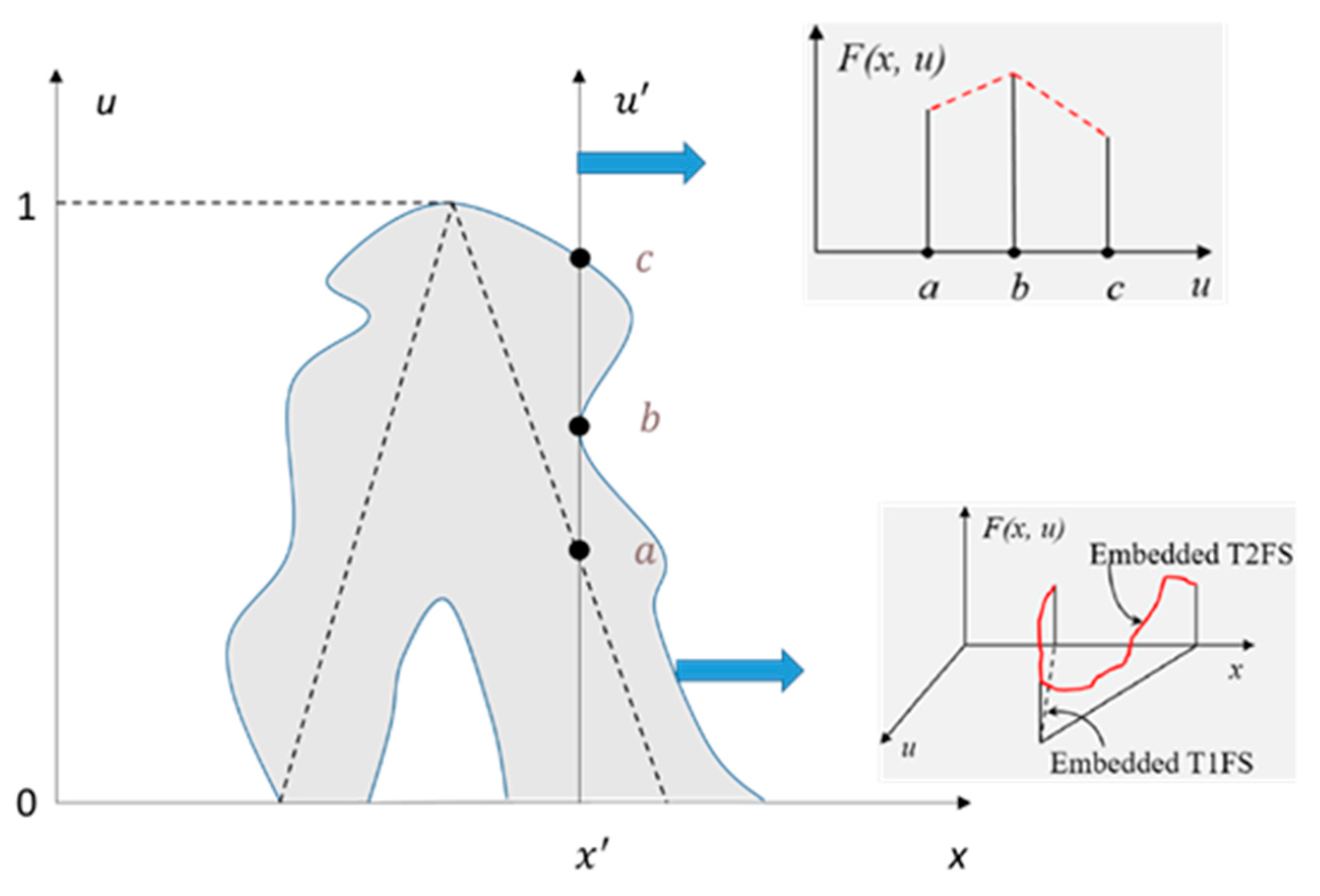
Fuzzy numbers, such as triangular fuzzy numbers, trapezoidal fuzzy numbers, Gaussian fuzzy numbers, and interval fuzzy numbers, are often used to deal with uncertain parameters with fuzzy characteristics in irrigation districts’ water resources management systems. However, the membership function of a fuzzy number is not necessarily a simple triangular function, a trapezoidal function, a Gaussian function, or an interval function; it may also be fuzzy. Therefore, the type-2 fuzzy introduces a sub-membership function to describe the uncertainty of the membership function. Its image is shown in Figure 2, where each membership degree corresponds to a series of unfixed numbers, posing a considerable obstacle to practical application. Therefore, an extra type reduction is required to convert T2FS into conventional T1FS so that they can be defuzzified to give crisp outputs. In the second step, the traditional fuzzy parameters are further fuzzified into type-2 fuzzy parameters, according to the value of the sub-membership degree, the type-2 fuzzy sets are divided into generalized type-2 fuzzy sets, triangular type-2 fuzzy sets and interval type-2 fuzzy sets. The triangular type-2 fuzzy sets represent a special type of type-2 fuzzy sets. With complexity between the general type-2 fuzzy set and the interval type-2 fuzzy set, it can achieve a balance between the sufficient representation of information and the high complexity of the calculation. So, in this study, the type-2 triangular fuzzy number is selected to deal with more complex fuzzy uncertainty parameters. Especially, the secondary membership function A ˜ = ( a 1 , a 2 , a 3 ; θ l , θ r ) of a type-2 triangular fuzzy sets is defined in the form:
μ ˜ A ˜ ( x ) = { ( x a 1 a 2 a 1 θ l x a 1 a 2 a 1 , x a 1 a 2 a 1 , x a 1 a 2 a 1 + θ r x a 1 a 2 a 1 ) ,   i f   x [ a 1 , a 1 + a 2 2 ] ( x a 1 a 2 a 1 θ l a 2 x a 2 a 1 , x a 1 a 2 a 1 , x a 1 a 2 a 1 + θ r a 2 x a 2 a 1 ) ,   i f   x [ a 1 + a 2 2 , a 2 ] ( a 3 x a 3 a 2 θ l x a 2 a 3 a 2 , a 3 x a 3 a 2 , a 3 x a 3 a 2 + θ r x a 2 a 3 a 2 ) ,   i f   x [ a 2 , a 2 + a 3 2 ] ( a 3 x a 3 a 2 θ l a 3 x a 3 a 2 , a 3 x a 3 a 2 , a 3 x a 3 a 2 + θ r a 3 x a 3 a 2 ) ,   i f   x [ a 2 + a 3 2 , a 3 ]
where a 1 , a 2 , a 3 are the true values and θ l , θ r are two parameters that characterize the fuzzy uncertainty of the primary membership of T2TFS.
The third step is to de-fuzzify the type-2 fuzzy parameters into definite values through the key-value-based reduction method. Suppose ξ ˜ is a type-2 fuzzy variable and μ ˜ ξ ˜ ( x ) is a secondary membership function. Introduce optimistic key value C V * [ μ ˜ ξ ˜ ( x ) ] , pessimistic key value C V * [ μ ˜ ξ ˜ ( x ) ] and key value C V [ μ ˜ ξ ˜ ( x ) ] to replace μ ˜ ξ ˜ ( x ) [13]. Then, ξ ˜ can be expressed as ξ ˜ = { α 1   α 2   α 3 m   1.0   n , where α1, α2, and α3 are the primary membership degrees of ξ ˜ , and m, 1.0, and n are the corresponding secondary membership degrees, respectively.
P o s { ξ ˜ α } = sup r α   μ ξ ˜ ( r ) = { 1.0   i f   0 α α 2 n   i f   α 2 α α 3 0   i f   α 3 < α 1.0
N e c { ξ ˜ α } = 1 sup r < α   μ ξ ˜ ( r ) = { 1.0   i f   0 α α 1 m   i f   α 1 < α α 2 0   i f   α 2 < α 1.0
C r { ξ ˜ α } = 1 2 ( P o s { ξ ˜ α } + N e c { ξ ˜ α } ) = { 1.0   i f   0 α α 1 1 + m 2   i f   α 1 < α α 2 n 2   i f   α 2 α α 3 0   i f   α 3 < α 1.0
where P o s { ξ ˜ α } is the Likelihood measure, N e c { ξ ˜ α } is the Necessity measure, and C r { ξ ˜ α } is the Credibility measure.
From this, the relevant key figures can be calculated as follows:
C V * ( ξ ) ˜ = sup α [ 0 , 1 ] ( α P o s { ξ ˜ α } )
C V * ( ξ ) ˜ = sup α [ 0 , 1 ] ( α N e c { ξ ˜ α } )
C V ( ξ ) ˜ = sup α [ 0 , 1 ] ( α C r { ξ ˜ α } )
where C V * ( ξ ) ˜ is the optimistic key value, C V * ( ξ ) ˜ is the pessimistic key value, and C V ( ξ ) ˜ is the key value.
Finally, according to the centroid method x x μ ˜ ξ ˜ ( x ) / x μ ˜ ξ ˜ ( x ) , the two-type fuzzy parameters can be de-fuzzified to certain values [14].

3.2. Chance-Constrained Programming (CCP)

Chance-constrained programming (CCP) is profitable for dealing with random uncertainty and analyzing the hazard of violating constraints. Consider an ordinary probabilistic stochastic linear programming as follows:
{ M i n   C ( t ) X A ( t ) X B ( t ) x j 0 ,   x j X ,   j = 1 , 2 , , n
where X is the decision variable, A(t), B(t), and C(t) are bunches with random components defined on a probability space T, t T. To solve this programming, a ‘counterpart’ deterministic edition will be defined. This can be achieved by using a CCP model, which consists of mending a certain level of probability p i [ 0 ,   1 ] for every constraint i . p i is a given degree of probability for constraint i (i.e., significance degree, which indicates the admissible risk of constraint defaulting), implying that the constraint i should be pleased with at least a probability degree of 1 − p i . The set of feasible solutions is accordingly restricted by the following constraints:
P r [ { t | A i ( t ) X b i ( t ) } ] 1 p i ,   A i ( t ) A ( t ) ,   i = 1 , 2 , , m
Taking p i = 0.01, 0.05, 0.10, 0.15, and 0.20, it means that the probability of this constraint being satisfied are 0.99, 0.95, 0.9, 0.85, and 0.8, respectively.
The constraint is generally nonlinear, and the bunch of feasible constraints is the convex only for some specific distributions and certain levels of p i , for example, when (i) aij is deterministic and bi is random (for all pi values), (ii) aij and bi are separate random coefficients, with pi maxr=1,2,…,R(1 − q r ), where qr is the probability consorted with the realization r, or (iii) aij and bi all have Gaussian distributions, with pi 0.5. When aij is deterministic and bi is random for model (8), given the distribution function of bi(t) as F[bi(t)], then b i ( t ) i ( p ) = F 1 ( p i ) . According to the description of distribution function, we have:
P r [ { t | b i ( t ) b i ( t ) ( p i ) } ] = p i
P r [ { t | b i ( t ) ( p i ) b i ( t ) } ] = 1 p i
If A i X = b i ( t ) ( p i ) , then P r [ { t | A i X b i ( t ) } ] = 1 p i ; if A i X b i ( t ) ( p i ) , thus P r [ { t | A i X b i ( t ) } ] 1 p i . Therefore, when aij is deterministic and bi is random, the constraint becomes linearization:
A i X b i ( t ) ( p i ) ,   i
where b i ( t ) ( p i ) = F i 1 ( p i ) , given the accumulative distribution function of bi, and the probability of defaulting constraint i. The problem with Equation (12) can only reflect the instance when A is deterministic. If both A and B are uncertain, the bunch of feasible constraints may become more complex. One potential method to deal with uncertainties in A, B and C is combining the type-2 fuzzy programming with the CCP framework, where type-2 fuzzy sets are used for reflecting the uncertainty in A and C [15].

3.3. Type-2 Fuzzy Chance-Constrained Programming (T2FCCP) Construction and Its Solution

Through incorporating the type-2 fuzzy programming (T2FP) within the chance-constrained programming (CCP) framework, a type-2 fuzzy chance-constrained programming (T2FCCP) model can be formulated. Combined with the actual situation of the cost and benefit of agricultural water and soil resources system in Lancang County, Puer City, Yunnan Province [16,17,18,19,20], it can be defined as follows:
M i n f = i = 1 I j = 1 J [ s c ˜ i I · C I A i j · t = 1 T C I i j t / ( C E i · F E i ) + G C ˜ i I · W I A i j · t = 1 T W I i j t / W I i j t + B C ˜ i I · T I A i j · t = 1 T ε i t · W Q T i t + T C ˜ i I · C I A i j · t = 1 T δ i t · W T Q i t ] + i = 1 I j = 1 J P C ˜ i j I · ( C I A i j + W I A i j + T I A i j )
The above objective function is limited by several constraints, including the following [20,21,22,23,24,25].
(1)
Surface water supply constraints
j = 1 J C I A i j · C I i j t C E i · F E i C W i t + S R i ( t 1 )
C r { P S ˜ W · t = 1 T C W i t T S ˜ W i } 1 λ c
(2)
Groundwater supply constraints
C r { j = 1 J P G ˜ W · W I A i · t = 1 T ( W I i t / F E ) T G ˜ W i } 1 λ w
(3)
Water demand constraints
j = 1 J ( C I i t · C I A i j + W I i t · W I A i j + T I i t · T I A i j ) + δ i t · W T Q i t · C E i · F E i · C I A i j + E P ˜ i t I · ( C I A i j + W I A i j + T I A i j ) W R ˜ i t I
(4)
Water balance constraints
S R i ( t 1 ) = S R i ( t 2 ) + C W i ( t 1 ) j = 1 J C I A i j · [ C I i j ( t 1 ) / ( C E i · F E i ) ]   S R i 0 = 0
(5)
Water distribution constraints
j = 1 J [ C I A i j · t = 1 T C I i j t + W I A i j · t = 1 T W I i j t + T I A i j · t = 1 T T I i j t + C I A i j · t = 1 T ( δ i t · W T Q i t · C E i · F E i ) ] 1 μ j = 1 J ( d j × P j )
(6)
Cropping area constraints
C I A m i n , i j C I A i j C I A m a x , i j
W I A m i n , i j W I A i j W I A m a x , i j
T I A m i n , i j T I A i j T I A m a x , i j
(7)
Food security constraints
j = 1 n [ Y A G i j · ( C I A i j + W I A i j + T I A i j ) ] P O i · P f
(8)
Water transfer constraints
ε i t , δ i t = { 0 ,   C I i j t · C I A i j + W I i j t · W I A i j + T I i j t · T I A i j + E P ˜ i t I W D ˜ m i n , i t I 1 ,   C I i j t · C I A i j + W I i j t · W I A i j + T I i j t · T I A i j + E P ˜ i t I < W D ˜ m i n , i t I
(9)
Structure constraints
C I i j t 0 ;   W I i j t 0 ;   T I i j t 0 ;   S R i t 0 ;   C W i t 0 ;   C I A i j 0 ;   W I A i j 0 ;   T I A i j 0
where i, j, and t represent tributaries, crops, and time interval, respectively; f is the cost of system (¥106); s c ˜ i I , G C ˜ i I , B C ˜ i I , and T C ˜ i I are the canal irrigation cost (yuan/m3), well irrigation cost (yuan/m3), reclaimed water treatment, distribution, operation and maintenance costs (yuan/m3), and water resource dispatch cost (yuan/m3), respectively; C I A i j , W I A i j , and T I A i j are the i tributary j crop canal irrigation area (hm2), i tributary j crop well irrigation area (hm2), and i tributary j crop reclaimed water irrigation area (hm2), respectively; P C ˜ i j I is the planting cost (yuan/hm2); C I i j t and W I i j t are the net canal irrigation water volume (m3/hm2) and net well irrigation water volume (m3/hm2), respectively; C E i and F E i are the canal water utilization coefficient and effective use coefficient of field water, respectively; ε i t and δ i t are 0–1 variables; W Q T i t and W T Q i t are the reclaimed water quota and external water transfer quota (m3/hm2), respectively; C W i t is the canal water supply (m3); S R i ( t 1 ) is the residual surface water (m3); P S ˜ W is the canal irrigation water intake coefficient; T S ˜ W i is the surface water availability (m3); λ c is the confidence level of canal irrigation; P G ˜ W is the well irrigation water intake coefficient; T G ˜ W i is the groundwater availability (m3); W I A i is the well irrigation area of i tributary (hm2); λ w is the confidence level of well irrigation; E P ˜ i t I is the effective precipitation; W R ˜ i t I is the water requirements to ensure the basic normal growth of crops (m3); μ is the effective utilization rate of cultivated land irrigation water; d j is the irrigation water quota for the j th major crop (m3/hm2); P j is the proportion of the sown area of the j th major crop (%); C I A m a x , i j and C I A m i n , i j are the maximum canal irrigation area (hm2) and minimum canal irrigation area (hm2), respectively; W I A m a x , i j and W I A m i n , i j are the maximum well irrigation area (hm2) and minimum well irrigation area (hm2), respectively; T I A m a x , i j and T I A m i n , i j are the maximum reclaimed water irrigation area (hm2) and minimum reclaimed water irrigation area (hm2), respectively; Y A G i j is the yield (kg/hm2); P O i is the population for i tributary; P f is the food demand per capita (kg/capita); W D ˜ m i n , i t I is the minimum water requirement (m3/hm2).
The process of solving the type-2 fuzzy chance—constrained programming model (T2FCCP) is as follows. (1) According to the weight determination method and the parameter probability distribution, construct the type-2 fuzzy parameters. (2) According to the parameter probability distribution, construct random parameters. (3) Then, through the key-value-based type-2 fuzzy reduction method and chance constraint method, the type-2 fuzzy parameters and random parameters are converted into deterministic parameters. Through the above steps, the optimization model is solved. Choosing different agricultural water and soil resources system violation probabilities and three shared socio-economic paths (SSPs), they are brought into the optimization model to solve, the relationship between system violation probability, shared socio-economic pathways (SSPs) and system costs, water resources optimal allocation, and crop planting structure is obtained.

3.4. Harmony Evaluation Method

By establishing a set of indicators and evaluation criteria, the fuzzy membership method is adopted, each index is uniformly mapped to [0, 1] by using the piecewise function, and the comprehensive index reflecting the degree of regional harmony is calculated to characterize the degree of harmony of the object to be evaluated. This method is called “single index quantification–multiple index synthesis integration of multi criteria (SMI-P)” evaluation method [26,27].
(1)
Single-index quantification. According to the relationship between the changes from small to large indicators and the changes in the harmony degree of their representations, they can be divided into positive indicators and reverse indicators. The positive index harmony degree increases with the increase of the index value; the reverse index harmony degree decreases with the increase of the index value. Suppose a, b, c, d, and e are the worst value, poor value, passing value, better value and optimal value of a positive or negative index, respectively. Using feature points (a, 0), (b, 0.3), (c, 0.6), (d, 0.8), and (e, 1), then the calculation formula of harmony degree of the positive index and the reverse index are, respectively:
D S I i = { 0 ,   x i < a i 0.3 x i a i b i a i ,   a i x i < b i 0.3 + 0.3 x i b i c i b i ,   b i x i < c i 0.6 + 0.2 x i c i d i c i ,   c i x i < d i 0.8 + 0.2 x i d i e i d i ,   c i x i < d i 1 ,   e i x i
D S I i = { 1 ,   x i < e i 0.8 + 0.2 d i x i d i e i ,   e i x i < d i 0.6 + 0.2 c i x i c i d i ,   d i x i < c i 0.3 + 0.3 b i x i b i c i ,   c i x i < b i 0.3 a i x i a i b i ,   b i x i < a i 0 ,   a i x i
where D S I i is the harmony degree of the i-th indicator at time t, i = 1, 2, …, n, n is the number of indicators; x i is the indicator value of the i-th indicator at time t.
(2)
Multi-indicator synthesis. Based on the calculation of the harmony degree of a single index, the harmony degree of each subsystem and the water resources–economic society–ecological environment system is calculated separately according to the method of weighted summation. Assume that the value of a quantitative index at time t is Y i ( t ) , its harmony degree is D S I i ( Y i ( t ) ) , then the water resources subsystem harmony degree (WHD), the economic and social subsystem harmony degree (SEHD), and the environmental subsystem harmony degree (EHD) are, respectively:
D W H ( t ) = i = 1 n 1 ω i × D S I i ( Y 1 i ( t ) )
D S E H ( t ) = i = 1 n 2 ω i × D S I i ( Y 2 i ( t ) )
D E H ( t ) = i = 1 n 3 ω i × D S I i ( Y 3 i ( t ) )
where D W H ( t ) , D S E H ( t ) , and D E H ( t ) take values from 0 to 1, n 1 , n 2 , and n 3 are the number of subsystem indicators, respectively, and w i is the index weight calculated by using the entropy weight method and the analytic hierarchy process.
(3)
Multi-criteria integration. Based on the WHD, SEHD, and EHD calculated above, the water resources–economical society–environmental system harmony degree (WSEHD) is calculated by the weighted sum method, and the formula is
D W S E H ( t ) = k 1 D W H ( t ) + k 2 D S E H ( t ) + k 3 D E H ( t )
where the value of D W S E H ( t ) ranges from 0 to 1; k 1 , k 2 , and k 3 are weights of the corresponding subsystems; all take 1/3. In order to intuitively and objectively reflect the harmony level of the water resources–economical society–ecological environment system, according to the calculation results of WSEHD, seven harmony levels are set with a step size of 0.2, as shown in Table 2.

4. Application

4.1. Data Preparation

According to a special report on three-year data of rural and agricultural production in Lancang County, Puer, Yunnan Province and the investigation, monitoring, and analysis of groundwater pollution in Lancang County, the irrigation water sources in the agricultural water and soil resources system of Lancang County are addressed from four aspects: surface water, groundwater, reclaimed water, and circulating water. According to the historical flow data of Lancang County, the available water resources in the basin and their related probabilities are obtained, and they are divided into three flow levels: flood season, normal season, and dry season. They are used as basis scenarios for the calculation of agricultural production irrigation carrying capacity. Since the available water volume of surface water and groundwater has both random and fuzzy attributes, it is represented by type-2 fuzzy sets, and the violation probability on the right-hand side is set to 0.01, 0.05, 0.10, 0.15, and 0.20 for analysis, and 0–1 programming represents whether reclaimed water and external water transfer are required for agricultural irrigation. The main food crops in Lancang County include wheat, maize and rice, and the main cash crops include beans and potatoes. Their agricultural land use data are the 2019–2021 Lancang-Mekong River Basin Land Use Cover Data, which is China’s Resource Satellite (HJ-1/CCD) interpretation with a resolution of 30 m. The most effective way to realize the combination of remote sensing data and mathematical model is to use data assimilation technology. In this study, the sequential assimilation method is used to combine agricultural land use data and the mathematical model, observation error, and model error are fully considered. The population distribution data are the population spatial distribution data of the 1 km × 1 km grid in the Lancang-Mekong River Basin (National Qinghai-Tibet Plateau Scientific Data Center) [27,28,29,30].

4.2. Result Analysis and Discussions

4.2.1. Water Resources Optimal Allocation in Lancang County

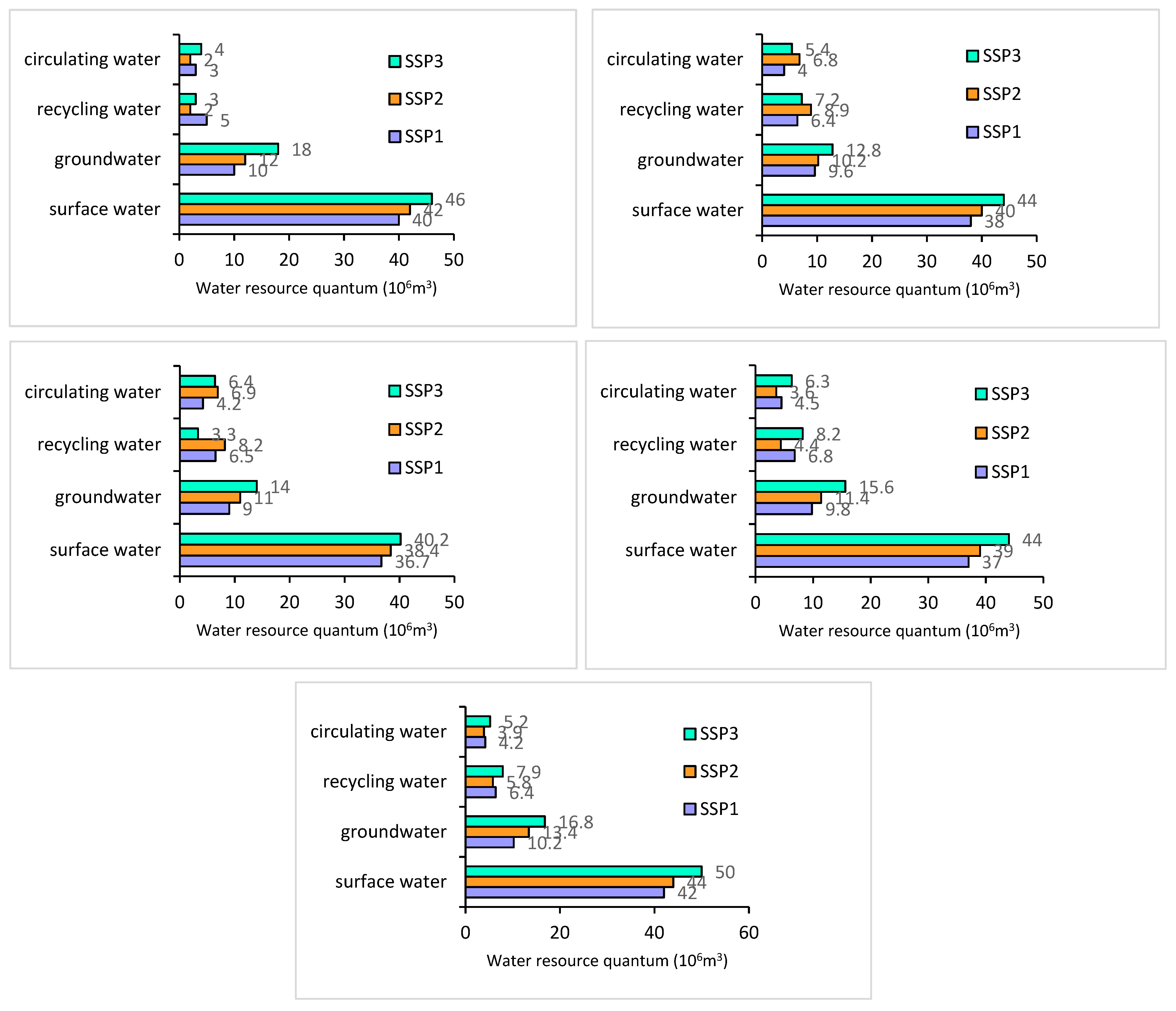
Figure 3 shows that, in five years, the surface water volume is the largest, which varies within 3.5~5 × 10⁷ m3, followed by the groundwater volume, which varies within 1~1.5 × 10⁷ m3. From SSP1 to SSP3, both surface water and groundwater volume are increasing. The water volume of reclaimed water and circulating water is relatively small, below 1 × 10⁷ m3, and the water volume under SSP2 in 2022 and 2023 is the largest under the three SSPs. However, in other years, the amount of water under SSP2 is the least, below 5 × 10⁶ m3 [31,32].

4.2.2. Planting Area Results of Different Crops in Lancang County

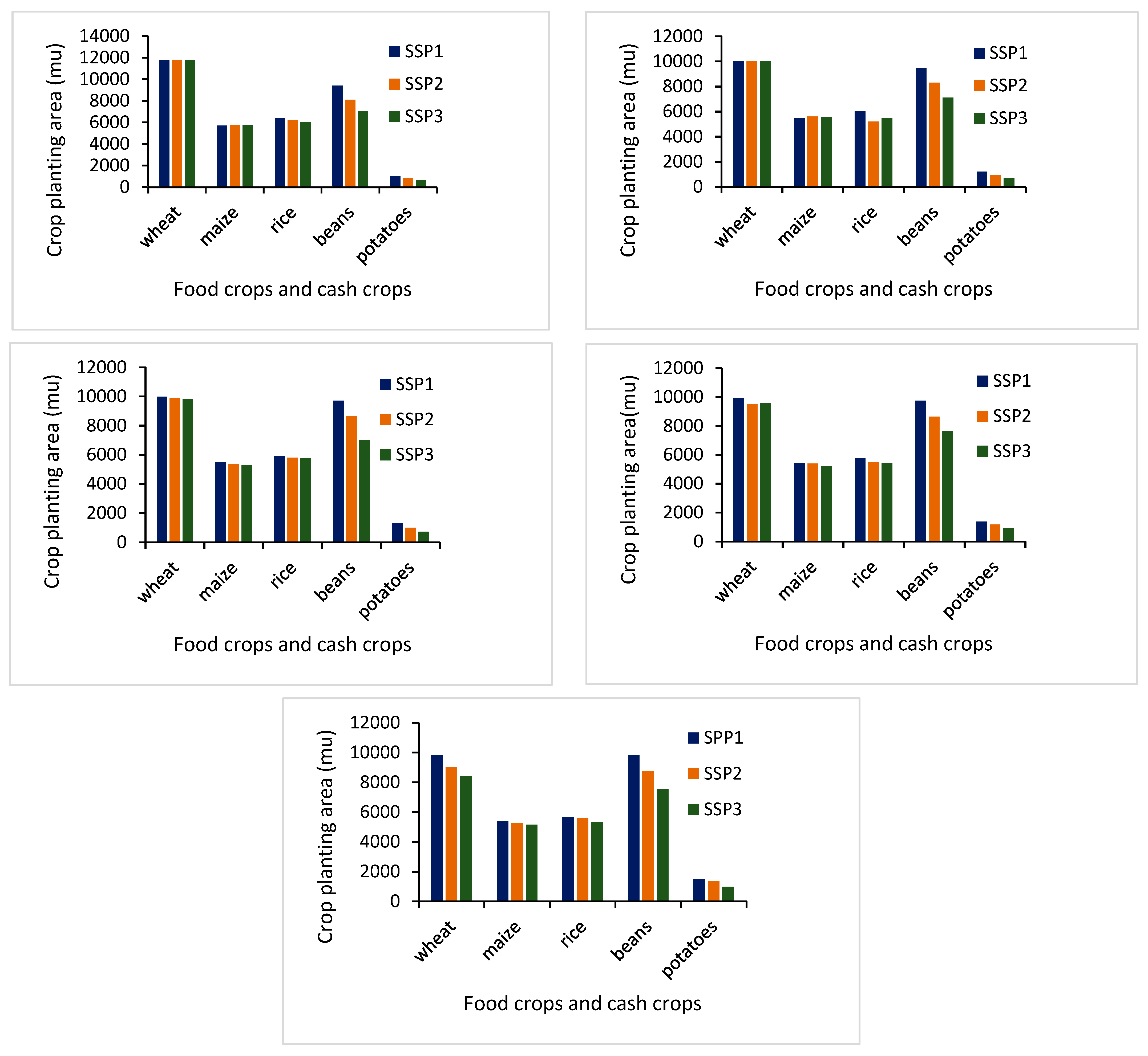
Figure 4 shows that, among food crops, the planting area of wheat is the largest. From 2021 to 2024, the planting area of wheat is about 10,000 mu under three SSPs. In 2025, the change is more dramatic, from SSP1 to SSP3, where it will decrease from 10,000 mu to 8000 mu [33]. The planting area of rice is slightly larger than that of maize, and both vary within 4000–6000 mu. Among cash crops, the planting area of soybean is much larger than that of potato, and the planting area of potato is less than 2000 mu, showing a downward trend from SSP1 to SSP3. In five years, from SSP1 to SSP3, the planting area of soybean dropped from about 10,000 mu to about 7000 mu.

4.2.3. The System Costs and Benefits in Lancang County

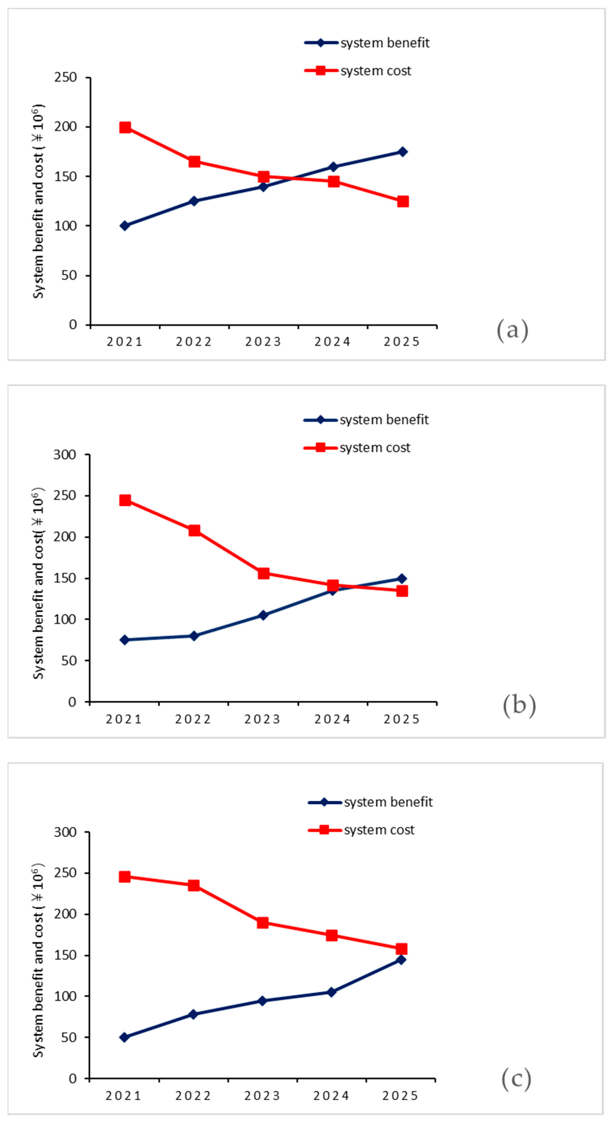
Figure 5a–c show that, under three SSPs, the cost of the water and soil resources system in Lancang County all showed a downward trend; from ¥2 × 10⁸ to about ¥1.2 × 10⁸ under SSP1; from ¥2.5 × 10⁸ to about ¥1.4 × 10⁸ under SSP2; and from ¥2.5 × 10⁸ to about ¥1.5 × 10⁸ under SSP3; the benefits all showed an upward trend; from ¥1 × 10⁸ to about ¥1.7 × 10⁸ under SSP1; from ¥7.5 × 10⁷ to about ¥1.5 × 10⁸ under SSP2; and from ¥5 × 10⁷ to about ¥1.5 × 10⁸ under SSP3. However, under SSP3, the cost of Lancang County’s water and soil resources system is always higher than the benefit. Under SSP1, the cost and benefit will be the same at the end of 2023, and under SSP2, the cost and benefit will be the same at the end of 2024, both at around¥1.5 × 10⁸. Then, the benefit exceeds the cost [34,35].

4.2.4. Harmony Evaluation in Lancang County

Based on the evaluation criteria of the harmony of water resources–economic society–ecological environment system, establish its evaluation index system, select the current year 2021, 2022 and the three planning years 2023, 2024, and 2025 for harmony evaluation [36]. The calculation results of WSEHD are shown in Table 3. In terms of time, with the passage of time, the harmony of the tributaries of Lancang County has gradually improved. It shows that water system connectivity and ecological restoration projects have a certain role in alleviating the water supply pressure, ecological environmental protection, and economic–society development in Yunnan Province. Most areas will change from a close to harmony level in 2021 to a basic harmonious level in 2025. Only the Nanlang River will gradually improve from the basic dissonance level in 2021 to the basic harmonious level. This is related to factors, such as poor natural resource endowment and underdeveloped economy, affecting the area near the Nanlang River.

4.2.5. Evaluation of Agricultural Production Irrigation Carrying Capacity in Lancang County

In the evaluation of agricultural production irrigation carrying capacity under the rigid constraints of water resources, it is necessary to strengthen the bottom-line constraints of resources and environment. As a constraint condition, water resources are affected by climate change conditions in different years, and the characteristics of instability are more obvious. Affected by the changes in water resources, such as precipitation, reclaimed water and circulating water, the irrigation water requirements of crops in wet years and dry years also have significant differences.
Therefore, in the process of carrying out the evaluation of agricultural production irrigation carrying capacity under the rigid constraints of water resources, this study will analyze the irrigation carrying capacity of agricultural production through a variety of water resource flow levels scenarios in Lancang County, in order to obtain objective carrying results of the agricultural production irrigation carrying capacity. In agricultural production, farmland is divided into paddy field, dry land, and vegetable land. This study aims to analyze the irrigation carrying capacity of agricultural production under the rigid constraints of water resources for farmland that needs artificial irrigation.
Considering the analysis of Lancang County’s water resources bulletin data in the past five years, due to the continuous economic and social development of Lancang County, population growth, and other factors, the structure of water use in Lancang County has changed to a certain extent. According to the Lancang County Water Resources Bulletin in recent years, the precipitation in Lancang County of 2021 will be 24.30% higher than the multi-year average, and the total water resources will be 32.80% higher than the multi-year average, which is a wet year. In 2022, the precipitation in Lancang County will be 26.20% lower than the multi-year average, and the total water resources will be 36.40% lower than the multi-year average, which is a dry year. Therefore, the water use structure of Lancang County in 2021 and 2022 is analyzed, and the evaluation of Lancang County’s farmland irrigation carrying capacity under the conditions of recent wet and dry years has a strong temporal representativeness.
Groundwater will affect the root growth of crops through soil moisture and play an important role in the growth and development of crops. Therefore, in the process of analysis, it is possible to consider reducing groundwater exploitation for non-agricultural purposes, and to use the non-agricultural irrigation water as a premise in the process. In this way, the structure of agricultural irrigation water is obtained. Then, it is possible to estimate the irrigation area that can be supported in agricultural production, providing a basis for formulating a water supply and demand balance plan [36,37].
(1)
Dry year scenario
In 2021, the total water resources of Lancang County accounted for 12.596 billion m3, and the total water supply was 26.078 billion m3. The water supply and utilization data of various water resources are shown in Table 4.
According to the use of water for non-agricultural production activities, including the conditions of preferential use of surface water for water use in production, life, and ecology, the water use structure in the case of preferential use of groundwater for farmland irrigation in Lancang County in 2021 was analyzed. The analysis results are shown in Table 5.
Under this hypothetical scenario analysis, in that year, the irrigation water of 11.052 billion m3 farmland in Lancang County exceeded the groundwater resource by 246 million m3. Since 2021 is a dry year, the irrigated farmland area of Lancang County that can carry 16,200 mu is calculated based on the comprehensive irrigation quota under the precipitation frequency of 75% of the dry year. If the farmland is irrigated according to 60% of the actual total groundwater resources in that year, it can only carry 8170 mu of irrigated farmland. If it needs to reach the level of the irrigated area of the year, 6.512 billion m3 of non-groundwater must be transferred for irrigation.
(2)
Wet year scenario
In 2022, the total water resources of Lancang County will be 135.68 billion m3, and the total water supply will be 280.2 billion m3. The water supply and utilization data of various water resources are shown in Table 6.
According to the conditions that surface water is preferentially used for water use in non-agricultural production activities, including water use in production, living, and ecology, the water use structure in Lancang County under the condition of preferential use of groundwater for farmland irrigation in 2022 is analyzed. The analysis results are shown in Table 7.
Under this hypothetical scenario analysis, the irrigation water of 14.06 billion m3 farmland in Lancang County can use groundwater, far less than 60% of the total groundwater resources of the year. Since 2022 is a non-dry year, the area of irrigated farmland that can be carried in Lancang County is 22,300 mu according to the comprehensive irrigation quota at 50% of the precipitation frequency.
(3)
Planning Scenario
Therefore, without considering the external transfer of irrigation water, refer to the scenarios in recent years to ensure that in the event of a dry year, the area of reasonable irrigated cultivated land that will not be affected is still guaranteed, which is 60% of the average annual groundwater resources in Lancang County. That is, 6.628 billion m3 is the upper limit of agricultural irrigation that groundwater in Lancang County can carry. The irrigation quota of Lancang County in normal years is used to estimate the irrigation carrying capacity of farmland that can be carried by groundwater in Lancang County in the future, with an area of no more than 23,580 mu.
In fact, since it is not yet possible to fully use groundwater for agricultural irrigation, and other industries do not use groundwater for water use, the above carrying capacity area is an extreme upper limit in the planning scenario.

4.2.6. Cost Comparison between CCP, FCCP, T2FCCP Model and Status Quo

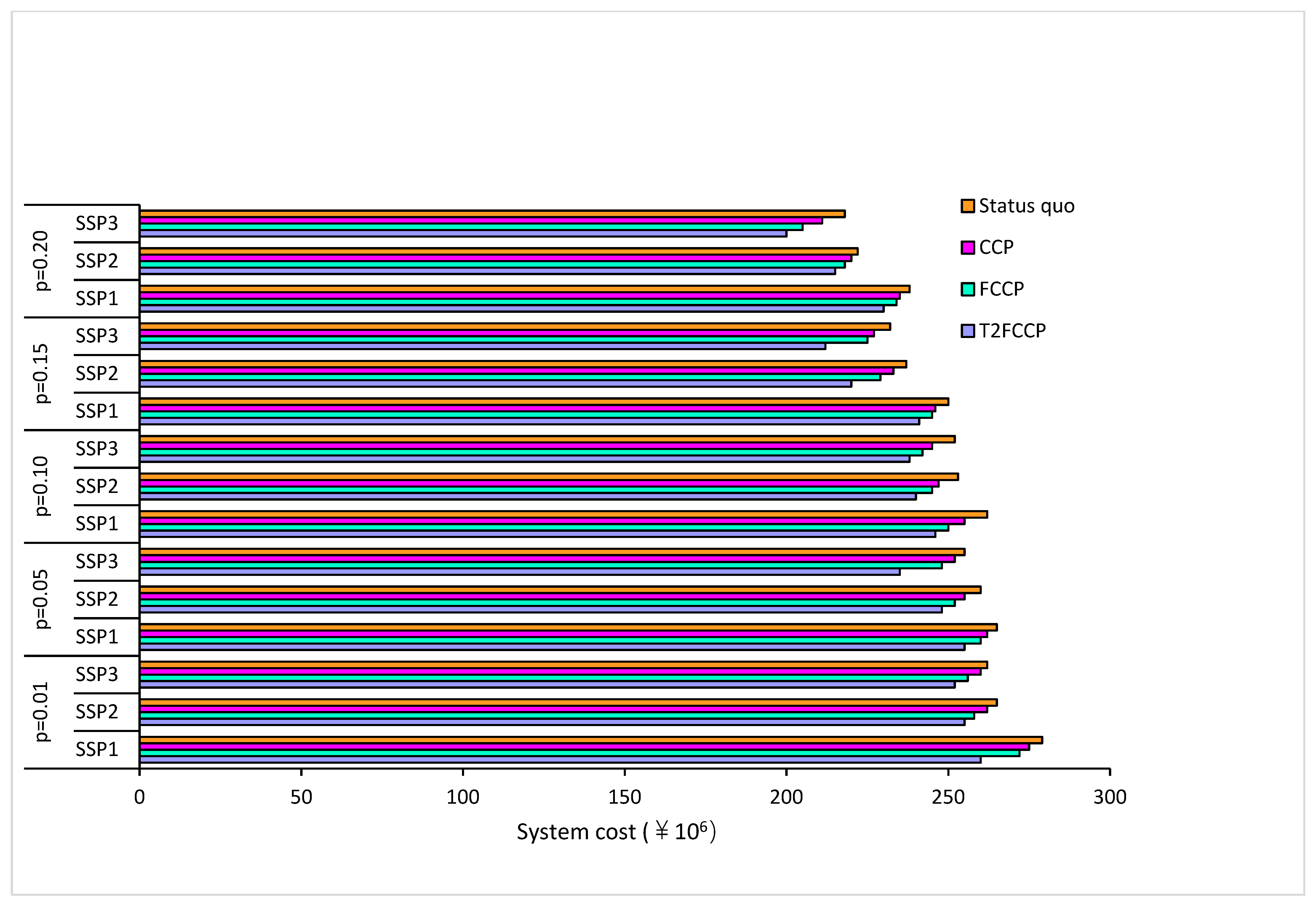
In terms of the cost of water and soil resources system in Lancang County, the results obtained by the CCP, FCCP, T2FCCP model and status quo vary within ¥2 × 10⁸~¥2.75 × 10⁸. As shown in Figure 6, under different system default probabilities, the cost gradually decreases from SSP1 to SSP3, and the cost of T2FCCP model is the lowest among four results.

5. Conclusions

In this research, a decision-making framework for water and soil resources management in Lancang County is designed [38]. Nowadays, there are few related studies about the improvement of agricultural production irrigation carrying capacity and the water resources optimal allocation in uncertain and complex environments using uncertainty optimization techniques. The high uncertainty and complexity in the social, economic, environmental, and policy data of Lancang County, Puer City, Yunnan Province can be well reflected in the Type 2 fuzzy chance-constrained programming model. Type 2 fuzzy sets are now adopted in considering the objective function and constraints of mathematical programming. The uncertainty of right-hand parameters in the constraints is represented by chance constraint programming. The water distribution constraints in constraints require the combined irrigation of surface water, groundwater, reclaimed water and circulating water shall not exceed the maximum comprehensive irrigation quota of farmland. Based on this, the agricultural production irrigation carrying capacity in Lancang County under different hydrological year scenarios is determined. The results obtained include the costs and benefits of the water and soil resources system, the optimal allocation of water resources, and the adjustment of planting structure schemes under different SSPs. The theory of harmony evaluation is introduced to evaluate the harmony degree of water resources carrying capacity of different tributaries in Lancang County. The comparison of the system cost obtained by the T2FCCP, FCCP, CCP model and status quo under different violation probabilities shows that the introduction of the Type 2 fuzzy sets can effectively reduce the cost of the agricultural water and soil resources system.
Lancang County, Puer City, Yunnan Province is located on the southwestern border of China and Myanmar and belongs to the Lancang–Mekong River Basin [39,40]. However, specific details for some portions were simplified. The natural factors (mainly meteorological conditions) and social factors (such as economic, social, management and technical conditions) of the region, as well as the issue of inter-basin water transfer projects should be fully considered. Therefore, how to express the ecological water supply and crop water demand with complex uncertainties is a difficult problem [41,42]. In addition, this study only considers the economic goal. In order to better achieve the sustainable development of regional agriculture, it can be considered to add social goals and ecological environment goals, and to introduce multi-objective optimization algorithms, such as evolutionary algorithm, particle swarm algorithm, tabu search, decentralized search, simulated annealing, artificial immune system, and ant colony algorithm to solve [43]. Moreover, new equipment and new technologies in agricultural water conservancy, such as distributed agricultural management practices and engineering techniques, and BMPs in agricultural non-point source pollution control, can be reflected in the model. These themes deserve further research to improve the framework.

Author Contributions

The study and the writing of the manuscript were carried out with contributions from all the authors. Writing—original draft preparation, Y.Z.; supervision, P.Y. All authors have read and agreed to the published version of the manuscript.

Funding

This research was financially supported by National Natural Science Foundation of China’s continuation of funding projects for innovative research groups (No. 51621061), Planning and Design of Donghui Ten Thousand Mu Modern Agricultural Science and Technology Demonstration Park in Lancang County, Yunnan Province (No. 69190031) and Research on multi-dimensional regulation model of water resources in ecological farmland in southern Xinjiang (No. 69112002).

Conflicts of Interest

The authors declare no conflict of interest and are grateful to Mo Li in the School of Water Conservancy & Civil Engineering, Northeast Agricultural University, for her support and encouragement in our research.

References

  1. Cao, R.; Huang, G.H.; Chen, J.P.; Li, Y.P.; He, C.Y. A chance-constrained urban agglomeration energy model for cooperative carbon emission management. Energy 2021, 223, 119885. [Google Scholar] [CrossRef]
  2. Cao, R.; Huang, G.H.; Chen, J.P.; Li, Y.P. A fractional multi-stage simulation-optimization energy model for carbon emission management of urban agglomeration. Sci. Total Environ. 2021, 774, 144963. [Google Scholar] [CrossRef]
  3. Cao, R.; Jin, X.M. Distribution Characteristics of Soil Moisture in the Three Rivers Headwaters Region, China. J. Environ. Inf. Lett. 2021, 6, 55–65. [Google Scholar] [CrossRef]
  4. Gu, W.; Shao, D.; Tan, X.; Shu, C.; Wu, Z. Simulation and optimization of multi-reservoir operation in inter-basin water transfer system. Water Res. Manag. 2017, 33, 3401–3412. [Google Scholar] [CrossRef]
  5. Chen, S.; Shao, D.; Tan, X.; Gu, W.; Lei, C. An interval multistage classified model for regional inter- and intra-seasonal water management under uncertain and nonstationary condition. Agric. Water Manag. 2017, 191, 98–112. [Google Scholar] [CrossRef]
  6. Zhang, C.L.; Li, M.; Guo, P. Two-Stage Stochastic Chance-Constrained Fractional Programming Model for Optimal Agricultural Cultivation Scale in an Arid Area. J. Irri. Drain. Eng. 2017, 143, 0001216. [Google Scholar] [CrossRef]
  7. Zhang, C.L.; Guo, P. An inexact CVaR two-stage mixed-integer linear programming approach for agricultural water management under uncertainty considering ecological water requirement. Ecol. Ind. 2018, 92, 342–353. [Google Scholar] [CrossRef]
  8. Zhang, C.L.; Li, M.; Guo, P. An interval multistage joint-probabilistic chance-constrained programming model with left-hand-side randomness for crop area planning under uncertainty. J. Clean. Prod. 2017, 167, 1276–1289. [Google Scholar] [CrossRef]
  9. Zhang, Y.; Yang, P.; Liu, X.; Adeloye, A.J. Simulation and Optimization Coupling Model for Soil Salinization and Waterlogging Control in the Urad Irrigation Area, North China. J. Hydrol. 2021, 607, 127408. [Google Scholar] [CrossRef]
  10. Zhang, Y.Q.; Yang, P.L. Agricultural Water Optimal Allocation Using Minimum Cross-Entropy and Entropy-Weight-Based TOPSIS Method in Hetao Irrigation District, Northwest China. Agriculture 2022, 12, 853. [Google Scholar] [CrossRef]
  11. Zhang, X.; Liu, K.; Wang, S.; Wu, T.; Li, X.; Wang, J.; Wang, D.; Zhu, H.; Tan, C.; Ji, Y. Spatiotemporal evolution of ecological vulnerability in the Yellow River Basin under ecological restoration initiatives. Ecol. Indic. 2022, 135, 108586. [Google Scholar] [CrossRef]
  12. Zhang, X.; Liu, K.; Li, X.; Wang, S.; Wang, J. Vulnerability assessment and its driving forces in terms of NDVI and GPP over the Loess Plateau, China. Phys. Chem. Earth Parts A B C 2022, 125, 103106. [Google Scholar] [CrossRef]
  13. Liu, K.; Li, X.K.; Long, X. Trends in groundwater changes driven by precipitation and anthropogenic activities on the southeast side of the Hu Line. Environ. Res. Lett. 2021, 16, 094032. [Google Scholar] [CrossRef]
  14. Maqsood, I.; Huang, G.H.; Scott Yeomans, J. An interval parameter fuzzy two-stage stochastic program for water resources management under uncertainty. Eur. J. Oper. Res. 2005, 167, 208–225. [Google Scholar] [CrossRef]
  15. Akhtari, S.; Sowlati, T. Hybrid optimization-simulation for integrated planning of bioenergy and biofuel supply chains. Appl. Energy 2020, 259, 114124. [Google Scholar] [CrossRef]
  16. Shabani, N.; Sowlati, T. A hybrid multi-stage stochastic programming-robust optimization model for maximizing the supply chain of a forest-based biomass power plant considering uncertainties. J. Clean. Prod. 2016, 112, 3285–3293. [Google Scholar] [CrossRef] [Green Version]
  17. Kamjoo, A.; Maheri, A.; Dizqah, A.M.; Putrus, G.A. Multi-objective design under uncertainties of hybrid renewable energy system using NSGA-II and chance constrained programming. Int. J. Electr. Power Energy Syst. 2016, 74, 187–194. [Google Scholar] [CrossRef]
  18. Daneshvar, M.; Mohammadi-Ivatloo, B.; Zare, K. Two-stage optimal robust scheduling of hybrid energy system considering the demand response programs. J. Clean. Prod. 2020, 248, 119267. [Google Scholar] [CrossRef]
  19. Cui, H.; Guo, P.; Li, M.; Guo, S.; Zhang, F. A multi-risk assessment framework for agricultural land use optimization. Stoch. Environ. Res. Risk Asses. 2019, 33, 563–579. [Google Scholar] [CrossRef]
  20. Li, M.; Guo, P.; Singh, V.P.; Yang, G. An uncertainty-based framework for agricultural water-land resources allocation and risk evaluation. Agric. Water Manag. 2016, 177, 10–23. [Google Scholar] [CrossRef]
  21. Sun, H.Y.; Wang, S.F.; Hao, X.M. An Improved Analytic Hierarchy Process Method for the evaluation of agricultural water management in irrigation districts of north China. Agric. Water Manag. 2017, 179, 324–337. [Google Scholar] [CrossRef]
  22. Zhang, F.; Guo, S.; Ren, C.; Guo, P. Integrated IMO-TSP and AHP Method for Regional Water Allocation under Uncertainty. J. Water Res. Plan. Manag. 2018, 144, 04018025. [Google Scholar] [CrossRef]
  23. Zhao, J.; Li, M.; Guo, P.; Zhang, C.; Tan, Q. Agricultural Water Productivity Oriented Water Resources Allocation Based on the Coordination of Multiple Factors. Water 2017, 9, 490. [Google Scholar] [CrossRef]
  24. Chen, S.; Wang, S.; Shukla, M.K.; Wu, D.; Guo, X.; Li, D.; Du, T. Delineation of management zones and optimization of irrigation scheduling to improve irrigation water productivity and revenue in a farmland of Northwest China. Prec. Agric. 2020, 21, 655–677. [Google Scholar] [CrossRef]
  25. Ren, C.; Guo, P.; Li, M.; Li, R. An innovative method for water resources carrying capacity research—Metabolic theory of regional water resources. J. Environ. Manag. 2016, 167, 139–146. [Google Scholar] [CrossRef]
  26. He, L.; Wang, S.; Peng, C.; Tan, Q. Optimization of Water Consumption Distribution Based on Crop Suitability in the Middle Reaches of Heihe River. Sustainability 2018, 10, 2119. [Google Scholar] [CrossRef] [Green Version]
  27. Wang, S.F.; Singh, V.P. Spatio-Temporal Variability of Soil Water Content under Different Crop Covers in Irrigation Districts of Northwest China. Entropy 2017, 19, 410. [Google Scholar] [CrossRef] [Green Version]
  28. Gui, Z.Y.; Li, M.; Guo, P. Simulation-based inexact fuzzy semi-infinite programming method for agricultural cultivated area planning in the Shiyang River basin. J. Irri. Drain. Eng. 2017, 143, 0001118. [Google Scholar] [CrossRef]
  29. Zhang, C.L.; Li, M.; Guo, P. Trend detection and stochastic simulation prediction of streamflow at Yingluoxia hydrological station, Heihe River Basin, China. Front. Agric. Sci. Eng. 2017, 4, 81–96. [Google Scholar] [CrossRef] [Green Version]
  30. Zhang, F.; Li, M.; Guo, S.; Zhang, C.; Guo, P. Integrated uncertain models for runoff forecasting and crop planting structure optimization of the Shiyang River Basin, north-west China. Front. Agric. Sci. Eng. 2018, 5, 177–187. [Google Scholar] [CrossRef]
  31. Gui, Z.; Zhang, C.; Li, M.; Guo, P. Risk analysis methods of the water resources system under uncertainty. Front. Agric. Sci. Eng. 2015, 2, 205–215. [Google Scholar] [CrossRef]
  32. Lu, H.W.; Huang, G.H.; Liu, L.; He, L. An interval-parameter fuzzy-stochastic programming approach for air quality management under uncertainty. Environ. Eng. Sci. 2008, 25, 895–910. [Google Scholar] [CrossRef]
  33. Huang, G.H.; He, L.; Zeng, G.M.; Lu, H.W. Identification of Optimal Urban Solid Waste Flow Schemes under Impacts of Energy Prices. Environ. Eng. Sci. 2008, 25, 685–696. [Google Scholar] [CrossRef]
  34. He, L.; Huang, G.H.; Lu, H.W.; Zeng, G.M. Optimization of surfactant-enhanced aquifer remediation for a laboratory BTEX system under parameter uncertainty. Environ. Sci. Technol. 2008, 42, 2009–2014. [Google Scholar] [CrossRef] [PubMed]
  35. He, L.; Huang, G.H.; Zeng, G.; Lu, H. An Interval Mixed-Integer Semi-Infinite Programming Method for Municipal Solid Waste Management. J. Air Waste Manag. Ass. 2012, 59, 236–246. [Google Scholar] [CrossRef]
  36. He, L.; Huang, G.H.; Zeng, G.M.; Lu, H.W. Identifying optimal regional solid waste management strategies through an inexact integer programming model containing infinite objectives and constraints. Waste Manag. 2009, 29, 21–31. [Google Scholar] [CrossRef]
  37. Lu, H.W.; Huang, G.H.; He, L. A Two-Phase Optimization Model Based on Inexact Air Dispersion Simulation for Regional Air Quality Control. Water Air Soil. Poll. 2010, 211, 121–134. [Google Scholar] [CrossRef]
  38. Lu, H.W.; Huang, G.H.; He, L. Inexact rough-interval two-stage stochastic programming for conjunctive water allocation problems. J. Environ. Manag. 2009, 91, 261–269. [Google Scholar] [CrossRef]
  39. Lu, H.W.; Huang, G.H.; He, L. An inexact rough-interval fuzzy linear programming method for generating conjunctive water-allocation strategies to agricultural irrigation systems. Appl. Math. Model. 2011, 35, 4330–4340. [Google Scholar] [CrossRef]
  40. He, L.; Huang, G.H.; Lu, H.W. Greenhouse gas emissions control in integrated municipal solid waste management through mixed integer bilevel decision-making. J. Hazar. Mater. 2011, 193, 112–119. [Google Scholar] [CrossRef]
  41. He, L.; Huang, G.H.; Lu, H.W. Bivariate interval semi-infinite programming with an application to environmental decision-making analysis. Eur. J. Oper. Res. 2011, 211, 452–465. [Google Scholar] [CrossRef]
  42. He, L.; Huang, G.; Lu, H.; Wang, S.; Xu, Y. Quasi-Monte Carlo based global uncertainty and sensitivity analysis in modeling free product migration and recovery from petroleum-contaminated aquifers. J. Hazar. Mater. 2012, 219–220, 133–140. [Google Scholar] [CrossRef] [PubMed]
  43. Shi, B.; Lu, H.W.; Ren, L.X.; He, L. A fuzzy inexact two-phase programming approach to solving optimal allocation problems in water resources management. Appl. Math. Model. 2014, 38, 5502–5514. [Google Scholar] [CrossRef]
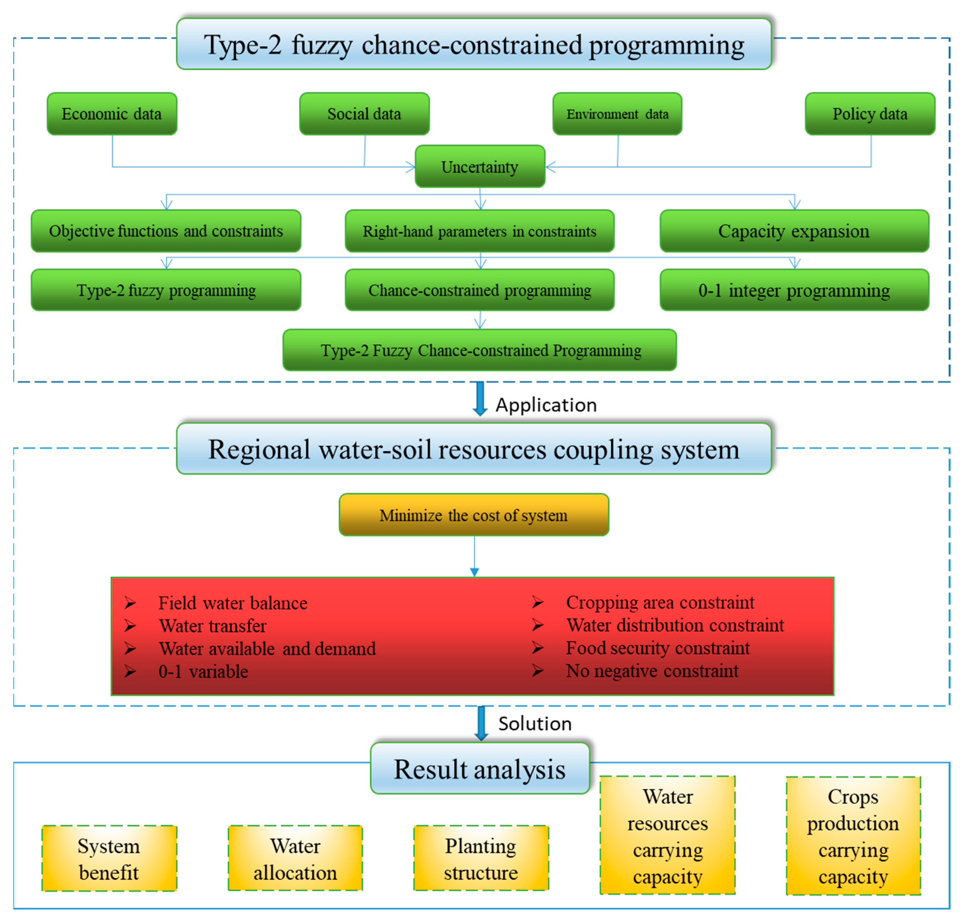
Figure 1. Decision support framework of resources and environment management for Lancang County.
Water 14 03641 g001
Figure 2. Membership function of type-2 fuzzy sets.
Water 14 03641 g002
Figure 3. Results of multiple water sources optimal allocation in 2021–2025 under different SSPs.
Water 14 03641 g003
Figure 4. Planting areas for different crops in 2021–2025 under different SSPs.
Water 14 03641 g004
Figure 5. System benefit and cost in 2021–2025 under different SSPs.
Water 14 03641 g005
Figure 6. System cost calculated by the CCP, FCCP, T2FCCP model and status quo in SSPs under different probabilities.
Water 14 03641 g006
Table 1. Summary of research on regional water resources optimal allocation.
DocumentAuthorLocationMethodHow to Use Optimization ModelIndex for Water AllocationTemporal ScaleSpatial ScaleScenarios
An inexact modeling approach for supporting water resources allocation under natural and social complexities in a border city of China and MyanmarChen et al., 2021Southwest ChinaITSFCCPReflect the trade-offs between the system benefits and risksFuzzy sets, discrete
intervals, probability distribution and credibility levels
2005–2016Prefecture-level cityFlow levels
A Stochastic Optimization Model for Agricultural Irrigation Water Allocation Based on the Field Water CycleYan et al., 2018Northwest ChinaTSCCPConsidering field water cycle processDifferent crops and months2000–2015Irrigation District
level
Different flow levels and constraint-violation risk levels
Efficient and Economical Allocation of Irrigation Water under a Changing Environment: a Stochastic Multi-Objective Nonlinear Programming ModelYan et al., 2018Northwest ChinaSMONLPTrade-offs between NEB and IWUEDifferent crops and monthsFrom April to September in 2016Irrigation District
level
weighting factor of objective functions and violating probability
This studyZhang et al., 2022Southwest ChinaT2FCCPConjunction with the Harmony Evaluation MethodHarmony level2021–2025County areaThree SSPs
Table 2. Harmonious grading of water resources-economic society-ecological environment system.
WSEHD0(0, 0.2)[0.2, 0.4)[0.4, 0.6)[0.6, 0.8)[0.8, 1)1
Harmony leveltotally discordantless harmoniousbasic dissonanceclose to harmonybasic harmonymore harmoniouscomplete harmony
Table 3. Current year and planning year WSEHD calculation results and harmony level.
20212022202320242025
NumberTributariesWSEHD Harmony LevelWSEHD Harmony LevelWSEHD Harmony LevelWSEHD Harmony LevelWSEHD Harmony Level
1Shangyun River0.42 close to harmony0.41 close to harmony0.48 close to harmony0.62  basic harmony0.64  basic harmony
2Hei River0.43 close to harmony0.42 close to harmony0.54 close to harmony0.63  basic harmony0.71  basic harmony
3Mangpa River0.46 close to harmony0.51 close to harmony0.47 close to harmony0.65  basic harmony0.74  basic harmony
4Nanlang River0.36 basic dissonance0.38 basic dissonance0.42 close to harmony0.44  close to harmony0.72  basic harmony
Table 4. The amount of water resources and their utilization for Lancang County in 2021.
Total Water ResourcesTotal Amount of Water Resources Is Higher than the Average over the YearsPrecipitation Is Higher than the Multi-Year AverageGroundwater ResourcesFarmland Irrigation Water ConsumptionNon-Farmland Irrigation Water ConsumptionGroundwater SupplySurface Water SupplyReclaimed Water VolumeTotal Water Supply
125.96−28.62%−35.72%108.06110.52115.34118.0878.0812.8260.78
Unit: 106 m3.
Table 5. Agricultural water consumption in Lancang County under the assumption of non-agricultural priority use of surface water in 2021.
Total Surface Water Supply and Reclaimed WaterNon-Agricultural Water Use Exceeds Surface WaterRemaining after Deduction of Groundwater60% of the Groundwater Resources of the Year
80.2170.62135.2864.85
Unit: 106 m3.
Table 6. The amount of water resources and their utilization for Lancang County in 2022.
Total Water ResourcesTotal Amount of Water Resources Is Higher than the Average over the YearsPrecipitation Is Higher than the Multi-Year AverageGroundwater ResourcesFarmland Irrigation Water ConsumptionNon-Farmland Irrigation Water ConsumptionGroundwater SupplySurface Water SupplyReclaimed Water VolumeTotal Water Supply
135.6825.48%28.20%112.6556.4858.2565.430.518.2280.2
Unit: 106 m3.
Table 7. Agricultural water consumption in Lancang County under the assumption of non-agricultural priority use of surface water in 2022.
Total Surface Water Supply and Reclaimed WaterNon-Agricultural Water Use Exceeds Surface WaterRemaining after Deduction of Groundwater60% of the Groundwater Resources of the Year
85.2866.4140.667.6
Unit: 106 m3.
Publisher’s Note: MDPI stays neutral with regard to jurisdictional claims in published maps and institutional affiliations.