
Improving Mean Annual Precipitation Prediction Incorporating Elevation and Taking into Account Support Size


Abstract
1. Introduction
2. Materials and Methods
2.1. Study Area and Data
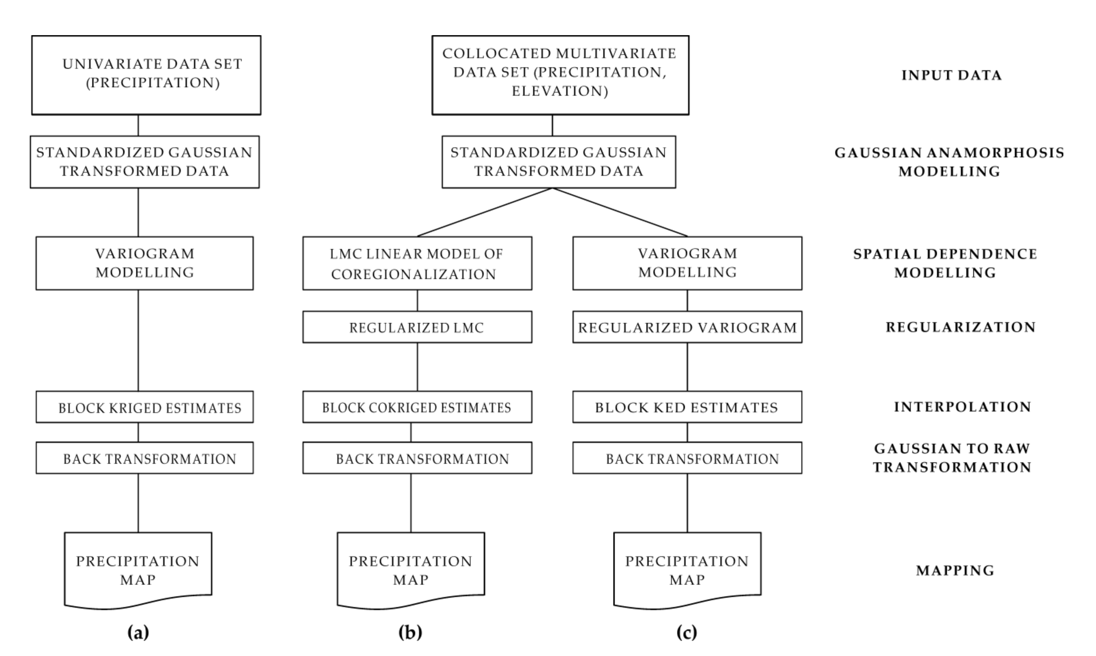
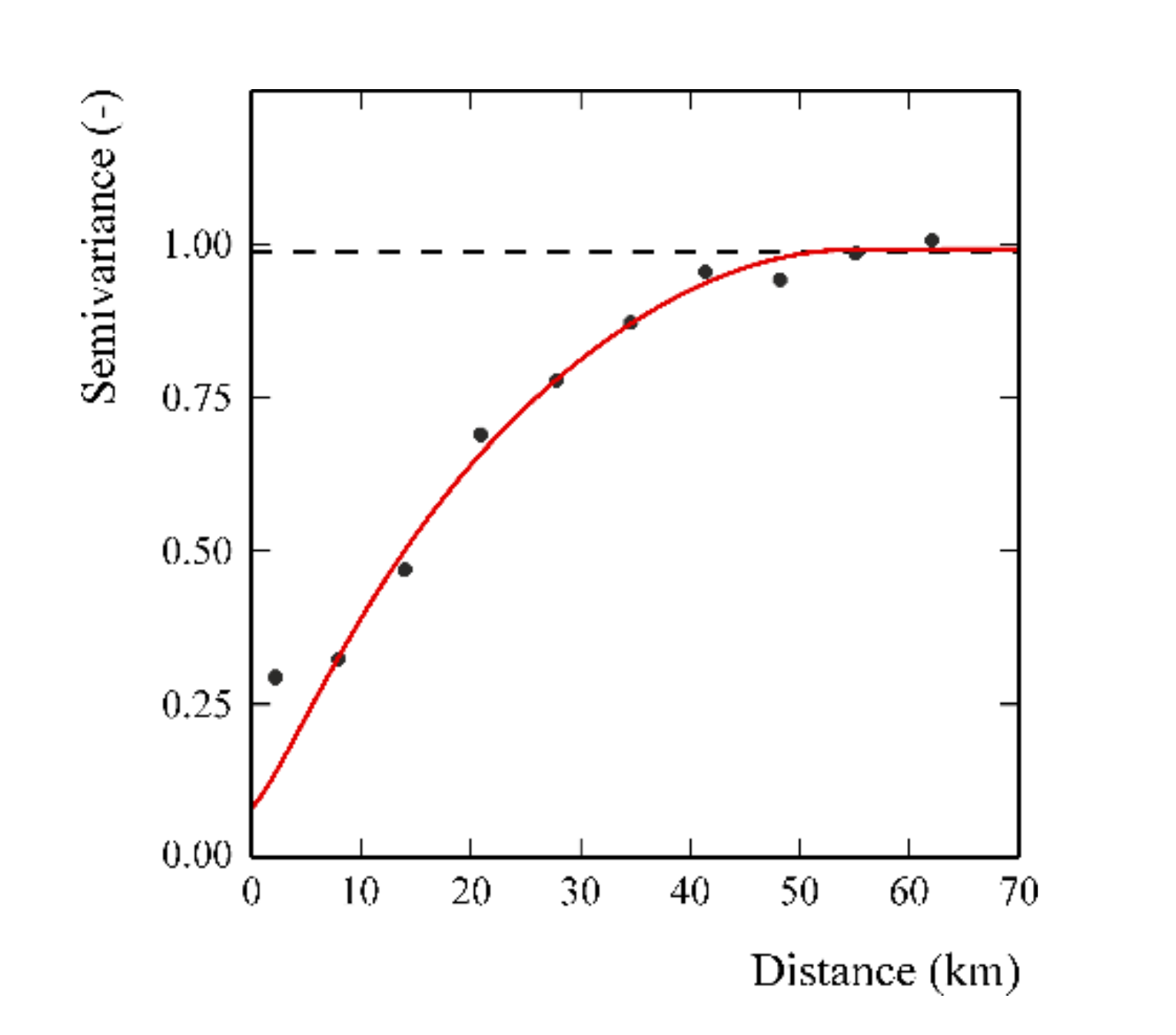
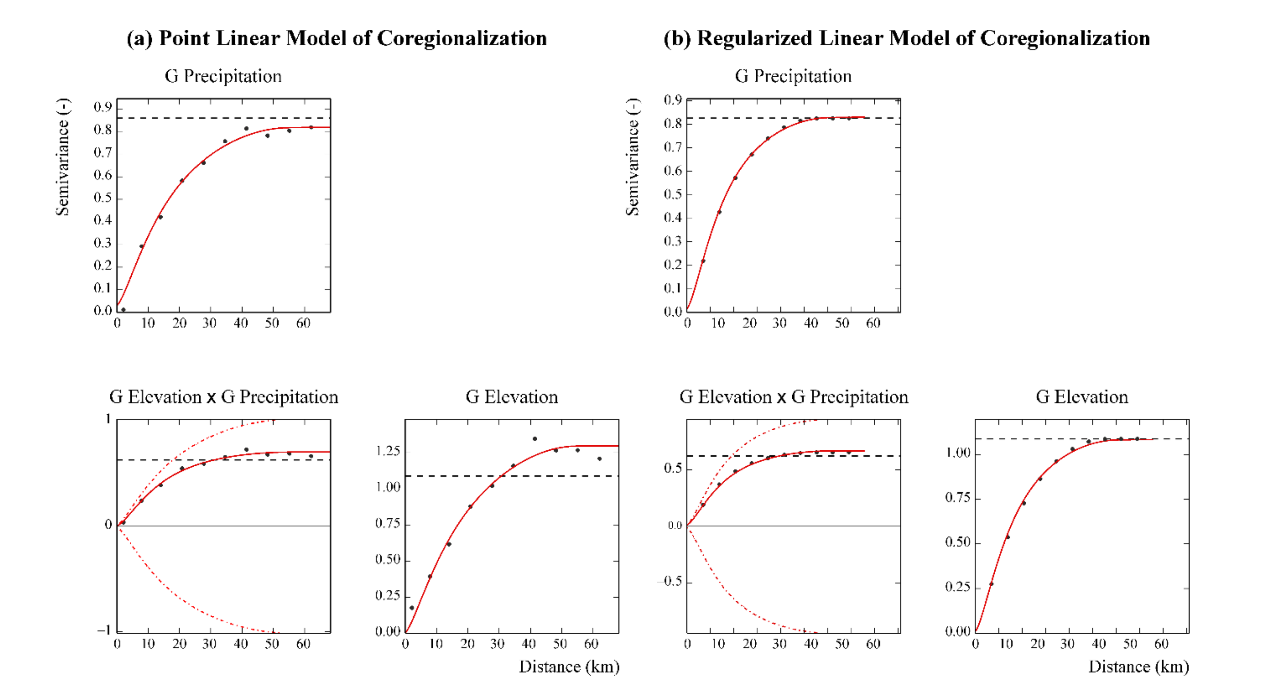
2.2. Geostatistical Approach
2.3. Validation Procedure
- Class 1 (10 precipitation data): elevation between 3 and 120 m a.s.l.
- Class 2 (9 precipitation data): elevation between 160 and 286 m a.s.l.
- Class 3 (9 precipitation data): elevation between 304 and 498 m a.s.l.
- Class 4 (9 precipitation data): elevation between 550 and 1358 m a.s.l.
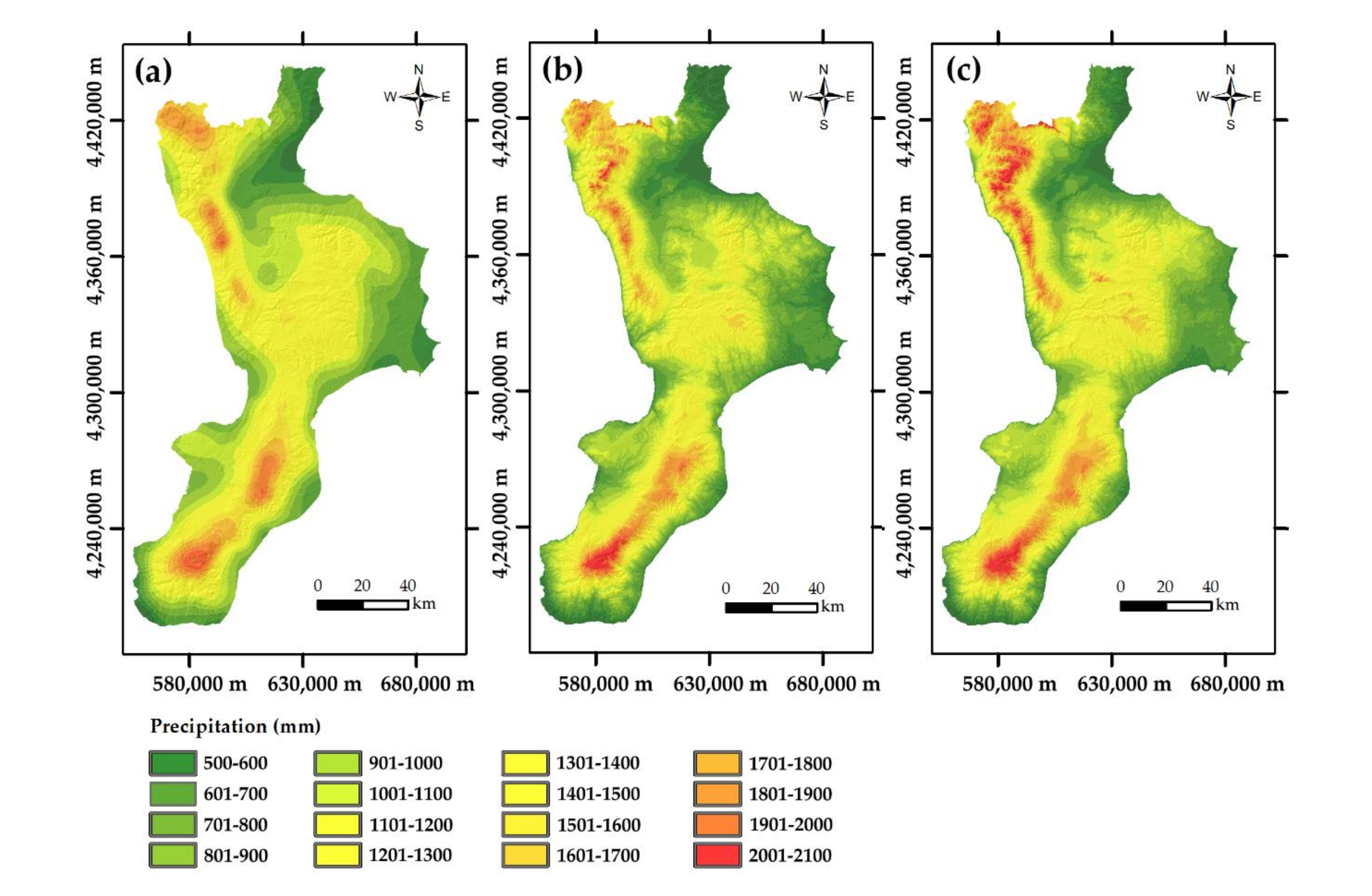
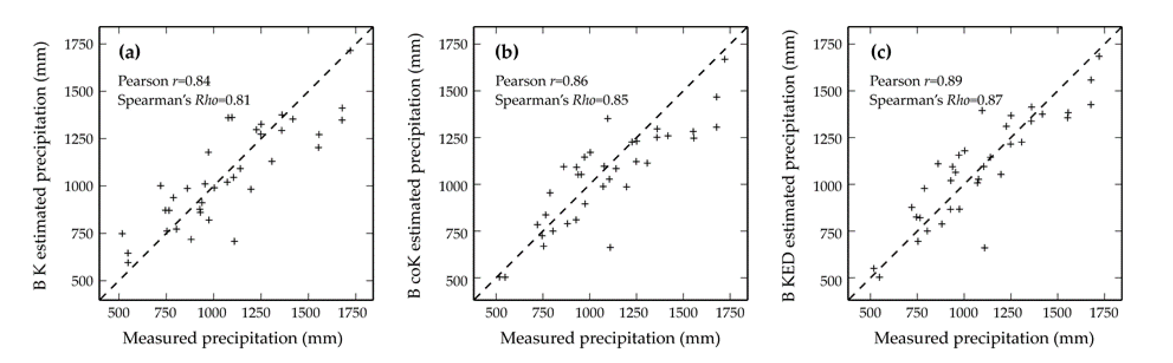
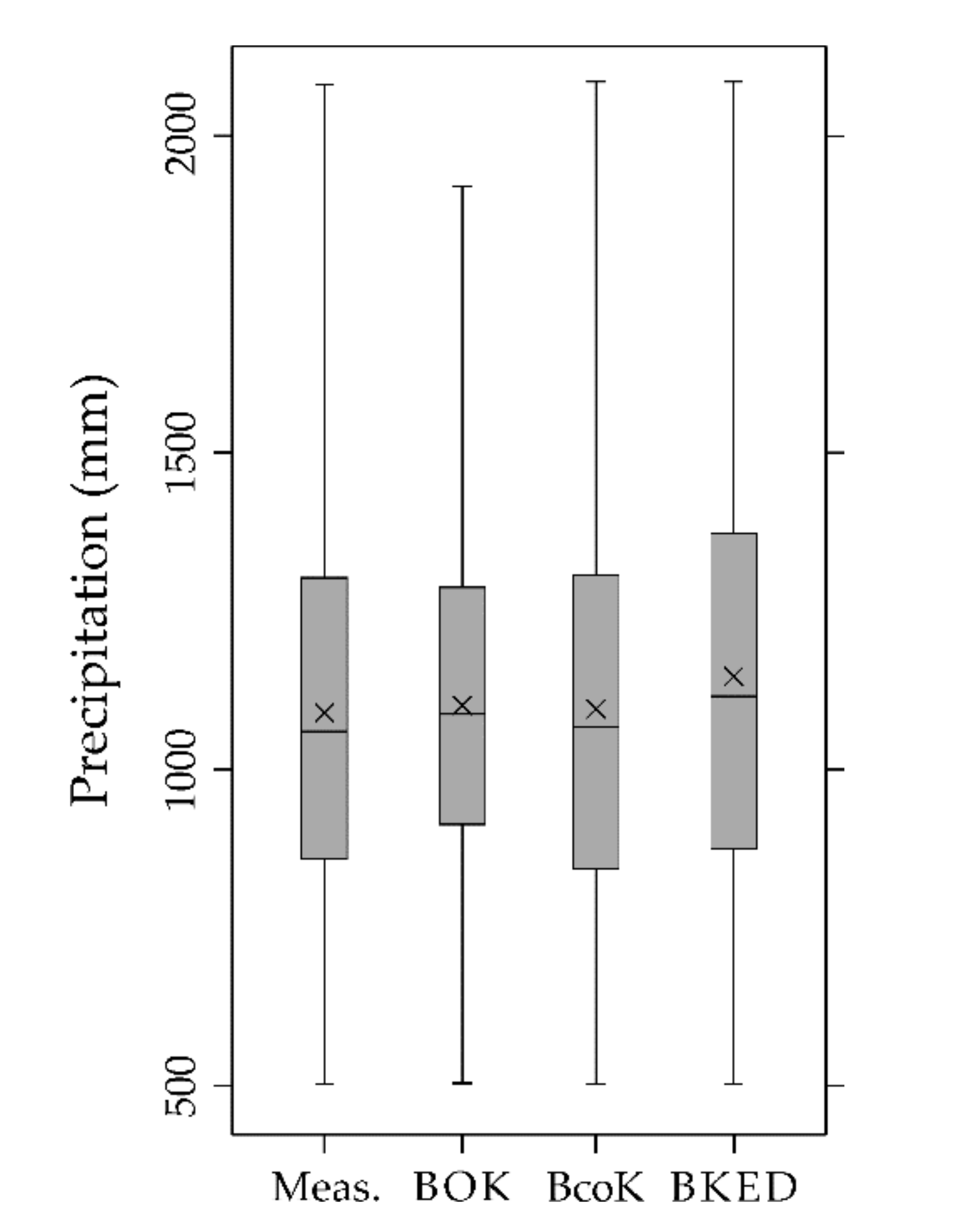
3. Results
4. Discussion
5. Conclusions
Author Contributions
Funding
Institutional Review Board Statement
Informed Consent Statement
Data Availability Statement
Acknowledgments
Conflicts of Interest
References
- Molden, D.; Vithanage, M.; de Fraiture, C.; Faures, J.M.; Gordon, L.; Molle, F.; Peden, D. Water Availability and Its Use in Agriculture. In Treatise on Water Science; Wilderer, P., Ed.; Elsevier Science: Amsterdam, The Netherlands, 2011; Volume 4, pp. 707–732. ISBN 978-0-44453-193-3. [Google Scholar]
- Deraisme, J.; Humbert, J.; Drogue, G.; Freslon, N. Geostatistical Interpolation of Rainfall in Mountainous Areas. In geoENV III—Geostatistics for Environmental Applications; Monestiez, P., Allard, D., Froidevaux, R., Eds.; Springer: Dordrecht, The Netherlands, 2001; pp. 57–66. [Google Scholar]
- Grimes, D.I.F.; Pardo-Igúzquiza, E. Geostatistical analysis of rainfall. Geogr. Anal. 2010, 42, 136–160. [Google Scholar] [CrossRef]
- Su, Y.; Zhao, C.; Wang, Y.; Ma, Z. Spatiotemporal variations of precipitation in China using surface gauge observations from 1961 to 2016. Atmosphere 2020, 11, 303. [Google Scholar] [CrossRef]
- Bostan, P.A.; Heuvelink, G.B.M.; Akyurek, S.Z. Comparison of regression and kriging techniques for mapping the average annual precipitation of Turkey. Int. J. Appl. Earth Obs. Geoinf. 2012, 19, 115–126. [Google Scholar] [CrossRef]
- Matheron, G. The Theory of Regionalized Variables and Its Applications; Ecole Nationale Superieure des Mines de Paris: Paris, France, 1971; Volume 5. [Google Scholar]
- Buttafuoco, G.; Lucà, F. Accounting for elevation and distance to the nearest coastline in geostatistical mapping of average annual precipitation. Environ. Earth Sci. 2020, 79, 11. [Google Scholar] [CrossRef]
- Lloyd, C.D. Multivariate Interpolation of Monthly Precipitation Amount in the United Kingdom; Springer: Dordrecht, The Netherlands, 2010; pp. 27–39. [Google Scholar]
- Szentimrey, T.; Bihari, Z.; Szalai, S. Comparison of Geostatistical and Meteorological Interpolation Methods (What is What?). In Spatial Interpolation for Climate Data: The Use of GIS in Climatology and Meteorology; ISTE: London, UK, 2010; pp. 45–56. ISBN 978-1-90520-970-5. [Google Scholar]
- Hengl, T.; AghaKouchak, A.; Percěc Tadić, M. Methods and data sources for spatial prediction of rainfall. In Rainfall: State of the Science; Testik, F.Y., Gebremichael, M., Eds.; American Geophysical Union: Washington, DC, USA, 2010; pp. 189–214. ISBN 978-1-11867-023-1. [Google Scholar]
- Burrough, P.; McDonnell, R.A. Principles of Geographical Information Systems; Oxford University Press: London, UK, 1998; p. 330. [Google Scholar]
- Diodato, N. The influence of topographic co-variables on the spatial variability of precipitation over small regions of complex terrain. Int. J. Climatol. 2005, 25, 351–363. [Google Scholar] [CrossRef]
- Collins, F.C.; Bolstad, P.V. A comparison of spatial interpolation techniques in temperature estimation. In Proceedings of the Third International Conference/Workshop on Integrating GIS and Environmental Modeling, Santa Fe, NM, USA, 21–25 January 1996; National Center for Geographic Information Analysis (NCGIA): Santa Barbara, NM, USA, 1996; pp. 122–134. [Google Scholar]
- Roe, G.H. Orographic precipitation. Annu. Rev. Earth Planet. Sci. 2005, 33, 645–671. [Google Scholar] [CrossRef]
- Hartkamp, D.; De Beurs, K.; Stein, A.; White, J.W. Interpolation Techniques for Climate Variables Interpolation; CIMMYT: Mexico City, Mexico, 1999; ISBN 1405-7484. [Google Scholar]
- Brunsdon, C.; McClatchey, J.; Unwin, D.J. Spatial variations in the average rainfall-altitude relationship in Great Britain: An approach using geographically weighted regression. Int. J. Climatol. 2001, 21, 455–466. [Google Scholar] [CrossRef]
- Kumari, M.; Singh, C.K.; Basistha, A.; Dorji, S.; Tamang, T.B. Non-stationary modelling framework for rainfall interpolation in complex terrain. Int. J. Climatol. 2017, 37, 4171–4185. [Google Scholar] [CrossRef]
- Lucà, F.; Buttafuoco, G.; Terranova, O. 2.03—GIS and Soil A2—Huang, Bo BT—Comprehensive Geographic Information Systems; Elsevier: Oxford, UK, 2018; pp. 37–50. ISBN 978-0-12-804793-4. [Google Scholar]
- Gotway, C.A.; Ferguson, R.B.; Hergert, G.W.; Peterson, T.A. Comparison of Kriging and Inverse-Distance Methods for Mapping Soil Parameters. Soil Sci. Soc. Am. J. 1996, 60, 1237–1247. [Google Scholar] [CrossRef]
- Chilès, J.-P.; Delfiner, P. Geostatistics: Modeling Spatial Uncertainty, 2nd ed.; Wiley Series in Probability and Statistics; John Wiley & Sons, Inc.: Hoboken, NJ, USA, 2012; ISBN 9781118136188. [Google Scholar]
- Dubrule, O. Comparing splines and kriging. Comput. Geosci. 1984, 10, 327–338. [Google Scholar] [CrossRef]
- Hutchinson, M.F. Interpolating mean rainfall using thin plate smoothing splines. Int. J. Geogr. Inf. Syst. 1995, 9, 385–403. [Google Scholar] [CrossRef]
- Goovaerts, P. Geostatistical approaches for incorporating elevation into the spatial interpolation of rainfall. J. Hydrol. 2000, 228, 113–129. [Google Scholar] [CrossRef]
- Hevesi, J.A.; Istok, J.D.; Flint, A.L. Precipitation Estimation in Mountainous Terrain Using Multivariate Geostatistics. Part I: Structural Analysis. J. Appl. Meteorol. 1992, 31, 661–676. [Google Scholar] [CrossRef]
- Lloyd, C.D. Assessing the effect of integrating elevation data into the estimation of monthly precipitation in Great Britain. J. Hydrol. 2005, 308, 128–150. [Google Scholar] [CrossRef]
- Berndt, C.; Rabiei, E.; Haberlandt, U. Geostatistical merging of rain gauge and radar data for high temporal resolutions and various station density scenarios. J. Hydrol. 2014, 508, 88–101. [Google Scholar] [CrossRef]
- Gabriele, S.; Chiaravalloti, F.; Procopio, A. Radar-rain-gauge rainfall estimation for hydrological applications in small catchments. Adv. Geosci. 2017, 44, 61–66. [Google Scholar] [CrossRef][Green Version]
- Gómez-Hernández, J.J.; Cassiraga, E.F.; Guardiola-Albert, C.; Rodríguez, J.Á. Incorporating Information from a Digital Elevation Model for Improving the Areal Estimation of Rainfall. In geoENV III—Geostatistics for Environmental Applications; Monestiez, P., Allard, D., Froidevaux, R., Eds.; Springer: Dordrecht, The Netherlands, 2001; pp. 67–78. [Google Scholar]
- Martínez-Cob, A. Estimation of mean annual precipitation as affected by elevation using multivariate geostatistics. Water Resour. Manag. 1995, 9, 139–159. [Google Scholar] [CrossRef]
- Pardo-Igúzquiza, E. Comparison of geostatistical methods for estimating the areal average climatological rainfall mean using data on precipitation and topography. Int. J. Climatol. 1998, 18, 1031–1047. [Google Scholar] [CrossRef]
- Bárdossy, A.; Pegram, G. Interpolation of precipitation under topographic influence at different time scales. Water Resour. Res. 2013, 49, 4545–4565. [Google Scholar] [CrossRef]
- Haiden, T.; Pistotnik, G. Intensity-dependent parameterization of elevation effects in precipitation analysis. Adv. Geosci. 2009, 20, 33–38. [Google Scholar] [CrossRef]
- Gotway, C.A.; Young, L.J. Combining incompatible spatial data. J. Am. Stat. Assoc. 2002, 97, 632–648. [Google Scholar] [CrossRef]
- Goovaerts, P. Geostatistics for Natural Resources Evaluation; Oxford University Press: New York, NY, USA, 1997; ISBN 0195115384. [Google Scholar]
- Longobardi, A.; Buttafuoco, G.; Caloiero, T.; Coscarelli, R. Spatial and temporal distribution of precipitation in a Mediterranean area (southern Italy). Environ. Earth Sci. 2016, 75, 1–20. [Google Scholar] [CrossRef]
- Buttafuoco, G.; Caloiero, T.; Guagliardi, I.; Ricca, N. Drought assessment using the reconnaissance drought index (RDI) in a southern Italy region. In Proceedings of the 6th IMEKO TC19 Symposium on Environmental Instrumentation and Measurements, Reggio Calabria, Italy, 24–25 June 2016; pp. 52–55. [Google Scholar]
- Webster, R.; Oliver, M.A. Geostatistics for Environmental Scientists; Statistics in Practice; John Wiley & Sons, Ltd.: Chichester, UK, 2007; ISBN 9780470517277. [Google Scholar]
- Wackernagel, H. Multivariate Geostatistics: An Introduction with Applications; Springer: Berlin/Heidelberg, Germany, 2003; ISBN 3540441425. [Google Scholar]
- Matheron, G. Principles of geostatistics. Econ. Geol. 1963, 58, 1246–1266. [Google Scholar] [CrossRef]
- Armstrong, M. Basic Linear Geostatistics; Springer: Berlin/Heidelberg, Germany, 1998; ISBN 978-3-540-61845-4. [Google Scholar]
- Myers, D.E. Co-Kriging—New Developments. In Geostatistics for Natural Resources Characterization; Verly, G., David, M., Journel, A.G., Marechal, A., Eds.; Springer: Dordrecht, The Netherlands, 1984; pp. 295–305. ISBN 978-94-010-8157-3. [Google Scholar]
- Deutsch, C.V.; Journel, A.G. GSLIB: Geostatistical Software Library, 2nd ed.; Oxford University Press: New York, NY, USA, 1998; ISBN 0195100158. [Google Scholar]
- Gotway, C.A.; Hartford, A.H. Geostatistical methods for incorporating auxiliary information in the prediction of spatial variables. J. Agric. Biol. Environ. Stat. 1996, 1, 17–39. [Google Scholar] [CrossRef]
- Castrignanò, A.; Buttafuoco, G.; Quarto, R.; Vitti, C.; Langella, G.; Terribile, F.; Venezia, A. A combined approach of sensor data fusion and multivariate geostatistics for delineation of homogeneous zones in an agricultural field. Sensors 2017, 17, 2794. [Google Scholar] [CrossRef]
- Bleines, C.; Deraisme, J.; Geffroy, F.; Jeannée, N.; Perseval, S.; Rambert, F. Isatis Technical References; Geovariances: Avon, France, 2018. [Google Scholar]
- Yang, Y.; Zhao, C.; Sun, L.; Wei, J. Improved Aerosol Retrievals Over Complex Regions Using NPP Visible Infrared Imaging Radiometer Suite Observations. Earth Space Sci. 2019, 6, 629–645. [Google Scholar] [CrossRef]
- Yang, X.; Zhao, C.; Luo, N.; Zhao, W.; Shi, W.; Yan, X. Evaluation and Comparison of Himawari-8 L2 V1.0, V2.1 and MODIS C6.1 aerosol products over Asia and the oceania regions. Atmos. Environ. 2020, 220, 117068. [Google Scholar] [CrossRef]
- Voltz, M.; Webster, R. A comparison of kriging, cubic splines and classification for predicting soil properties from sample information. J. Soil Sci. 1990, 41, 473–490. [Google Scholar] [CrossRef]
- Agterberg, F.P. Trend Surface Analysis. In Spatial Statistics and Models; Gaile, G.L., Willmott, C.J., Eds.; Springer: Dordrecht, The Netherlands, 1984; pp. 147–171. ISBN 978-90-481-8385-2. [Google Scholar]
- Carrera-Hernández, J.J.; Gaskin, S.J. Spatio temporal analysis of daily precipitation and temperature in the Basin of Mexico. J. Hydrol. 2007, 336, 231–249. [Google Scholar] [CrossRef]


| Data Set | Estimation Method | MAE (mm) | RMSEP (mm) | MRE (-) | G (-) |
|---|---|---|---|---|---|
| Whole validation set (37) | BOK 1 | 135.11 | 173.68 | 0.13 | 54.92 |
| BcoK 1 | 130.72 | 165.77 | 0.12 | 62.41 | |
| BKED 1 | 112.80 | 144.89 | 0.11 | 75.67 | |
| Elevation class 1 (10) | BOK 1 | 120.09 | 142.44 | 0.18 | 97.73 |
| BcoK 1 | 62.10 | 67.55 | 0.08 | 99.35 | |
| BKED 1 | 73.30 | 81.52 | 0.10 | 99.17 | |
| Elevation class 2 (9) | BOK 1 | 137.49 | 162.35 | 0.14 | 97.42 |
| BcoK 1 | 133.12 | 150.11 | 0.14 | 97.78 | |
| BKED 1 | 133.64 | 149.67 | 0.14 | 97.83 | |
| Elevation class 3 (9) | BOK 1 | 213.46 | 251.01 | 0.17 | 94.79 |
| BcoK 1 | 223.32 | 253.14 | 0.18 | 95.18 | |
| BKED 1 | 197.90 | 227.08 | 0.17 | 96.37 | |
| Elevation class 4 (9) | BOK 1 | 84.40 | 119.82 | 0.07 | 99.18 |
| BcoK 1 | 118.88 | 147.62 | 0.10 | 98.63 | |
| BKED 1 | 58.89 | 75.50 | 0.04 | 99.69 |
| Data Set | Estimation Method | r (-) | Rho (-) |
|---|---|---|---|
| Elevation class 1 (10) | BOK 1 | 0.89 | 0.79 |
| BcoK 1 | 0.97 | 0.89 | |
| BKED 1 | 0.96 | 0.81 | |
| Elevation class 2 (9) | BOK 1 | 0.52 | 0.57 |
| BcoK 1 | 0.42 | 0.45 | |
| BKED 1 | 0.45 | 0.42 | |
| Elevation class 3 (9) | BOK 1 | 0.74 | 0.57 |
| BcoK 1 | 0.64 | 0.52 | |
| BKED 1 | 0.72 | 0.60 | |
| Elevation class 4 (9) | BOK 1 | 0.81 | 0.58 |
| BcoK 1 | 0.86 | 0.82 | |
| BKED 1 | 0.91 | 0.90 |
Publisher’s Note: MDPI stays neutral with regard to jurisdictional claims in published maps and institutional affiliations. |
© 2021 by the authors. Licensee MDPI, Basel, Switzerland. This article is an open access article distributed under the terms and conditions of the Creative Commons Attribution (CC BY) license (http://creativecommons.org/licenses/by/4.0/).
Share and Cite
Buttafuoco, G.; Conforti, M. Improving Mean Annual Precipitation Prediction Incorporating Elevation and Taking into Account Support Size. Water 2021, 13, 830. https://doi.org/10.3390/w13060830
Buttafuoco G, Conforti M. Improving Mean Annual Precipitation Prediction Incorporating Elevation and Taking into Account Support Size. Water. 2021; 13(6):830. https://doi.org/10.3390/w13060830
Chicago/Turabian StyleButtafuoco, Gabriele, and Massimo Conforti. 2021. "Improving Mean Annual Precipitation Prediction Incorporating Elevation and Taking into Account Support Size" Water 13, no. 6: 830. https://doi.org/10.3390/w13060830
APA StyleButtafuoco, G., & Conforti, M. (2021). Improving Mean Annual Precipitation Prediction Incorporating Elevation and Taking into Account Support Size. Water, 13(6), 830. https://doi.org/10.3390/w13060830