
A Stepwise GIS Approach for the Delineation of River Valley Bottom within Drainage Basins Using a Cost Distance Accumulation Analysis


 , ,
, ,
Abstract
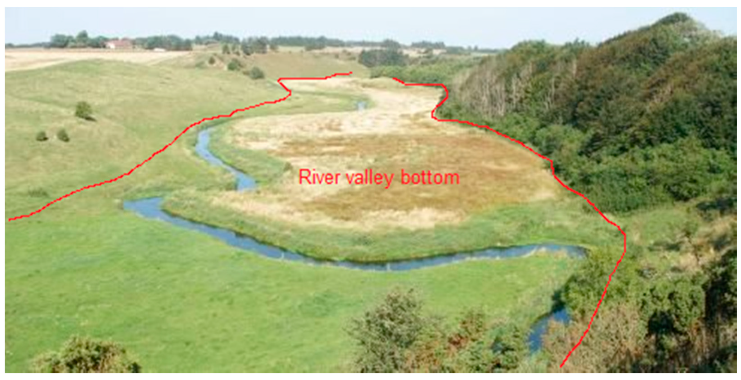
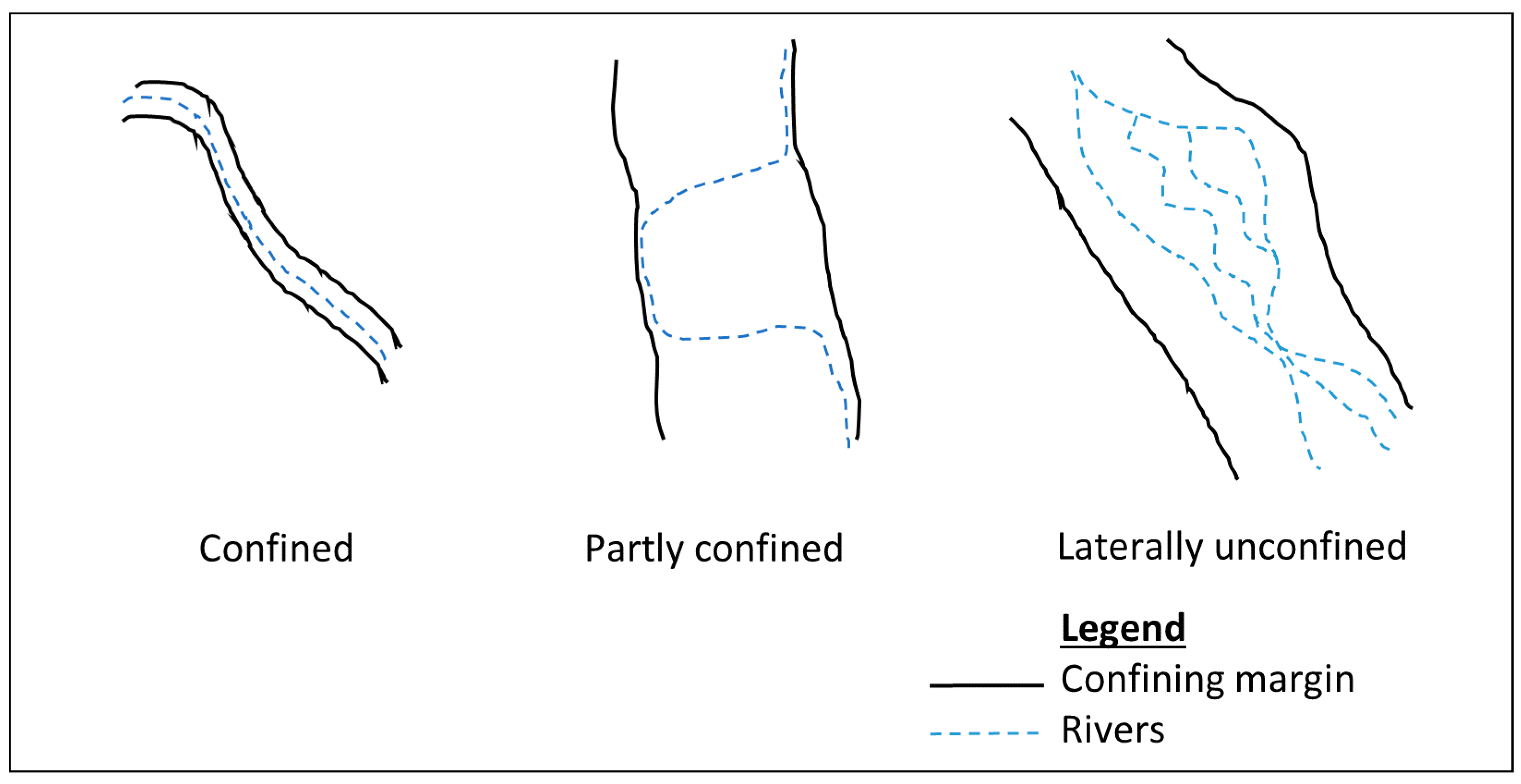
1. Introduction
2. Materials and Methods
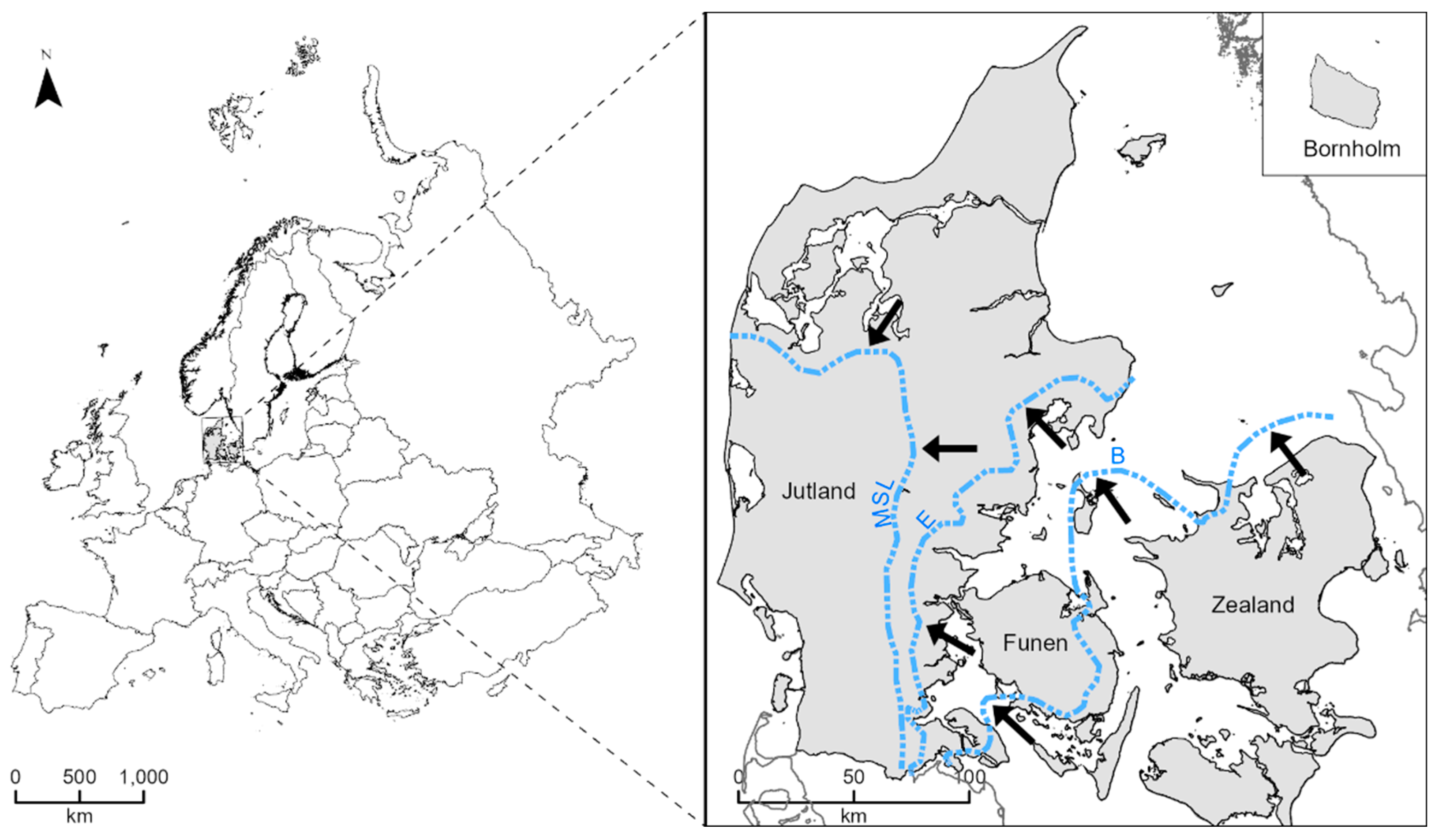
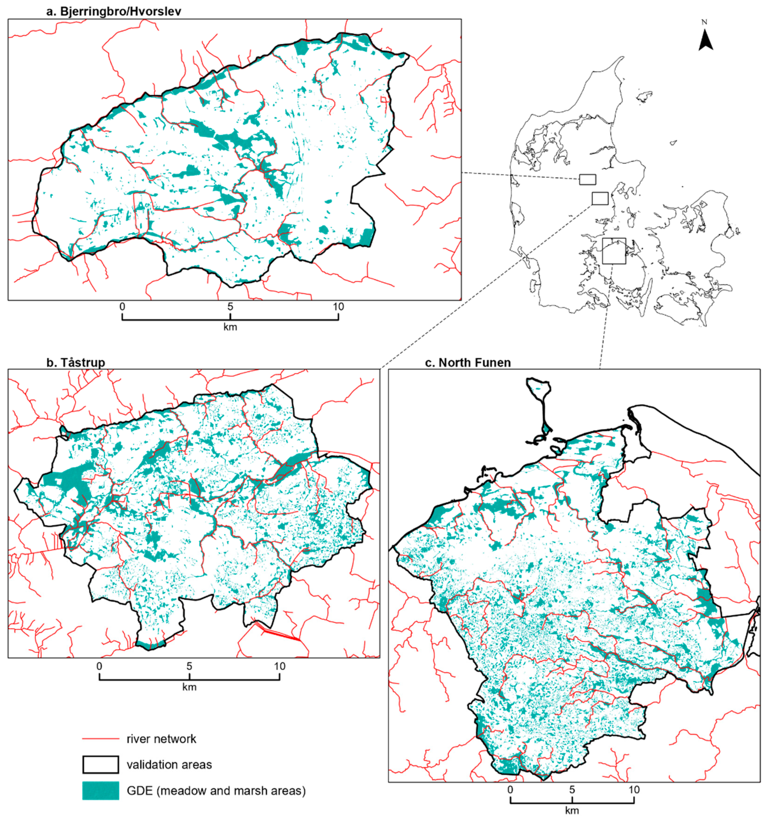
2.1. Study Area
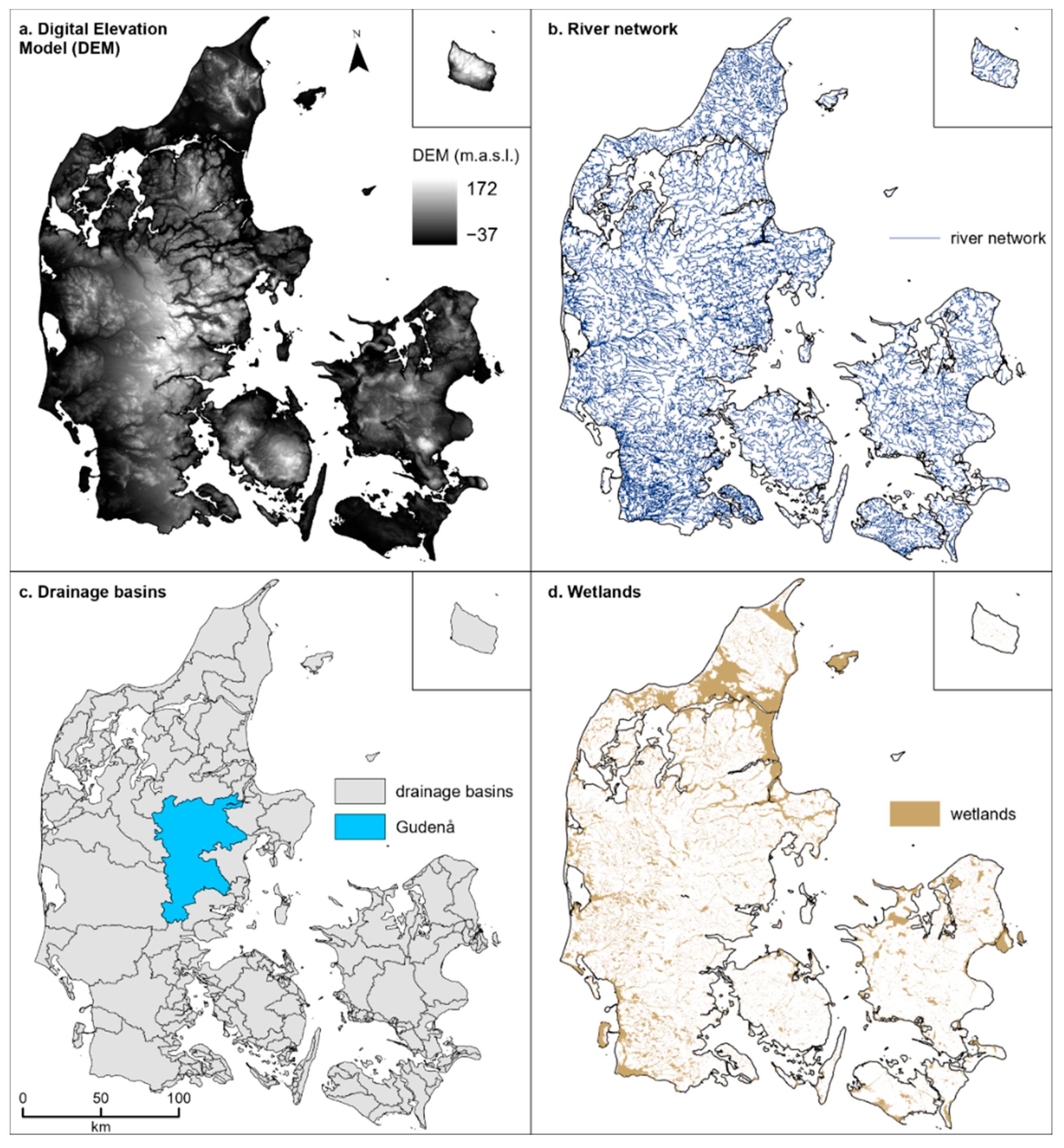
2.2. Data
3. Methodology
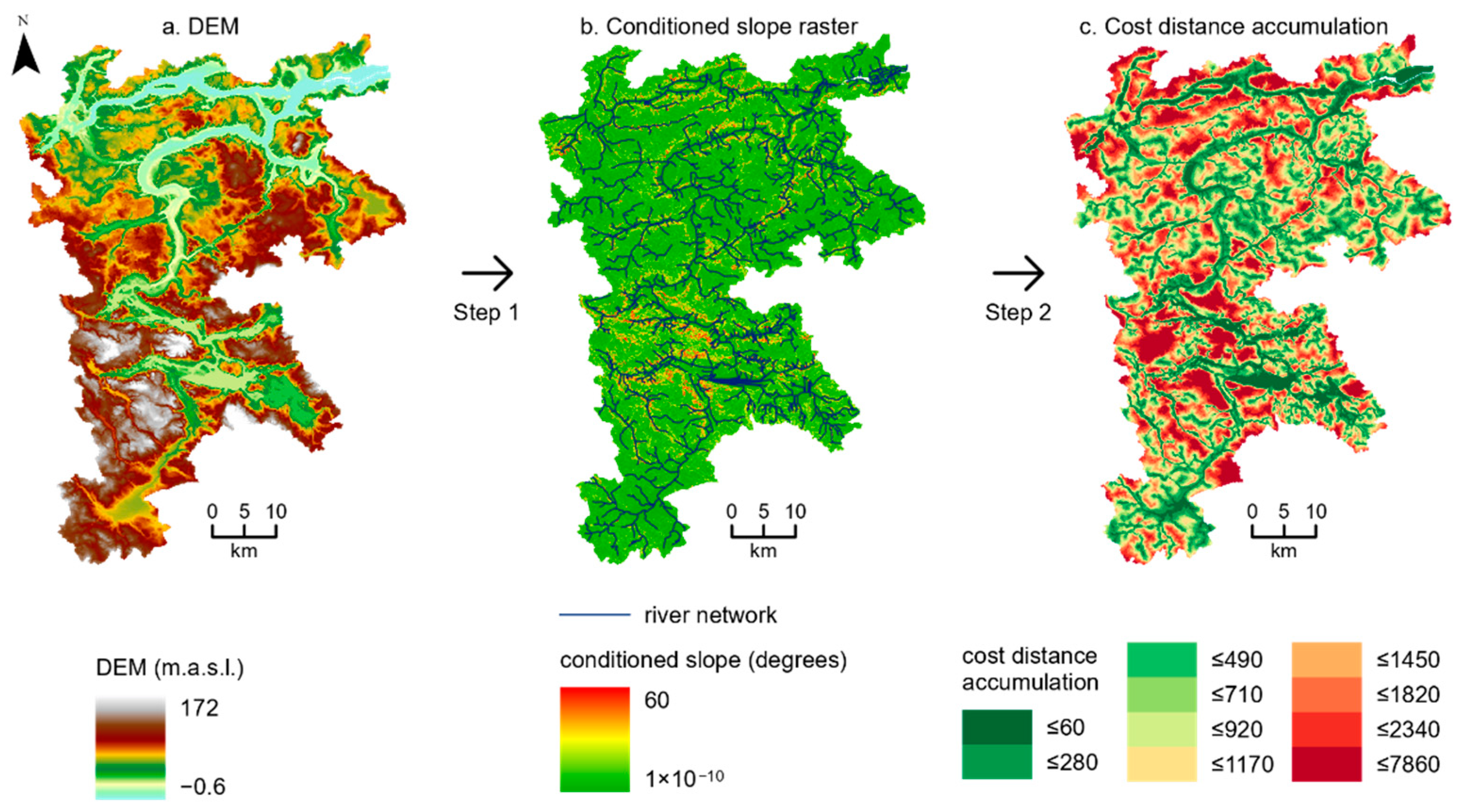
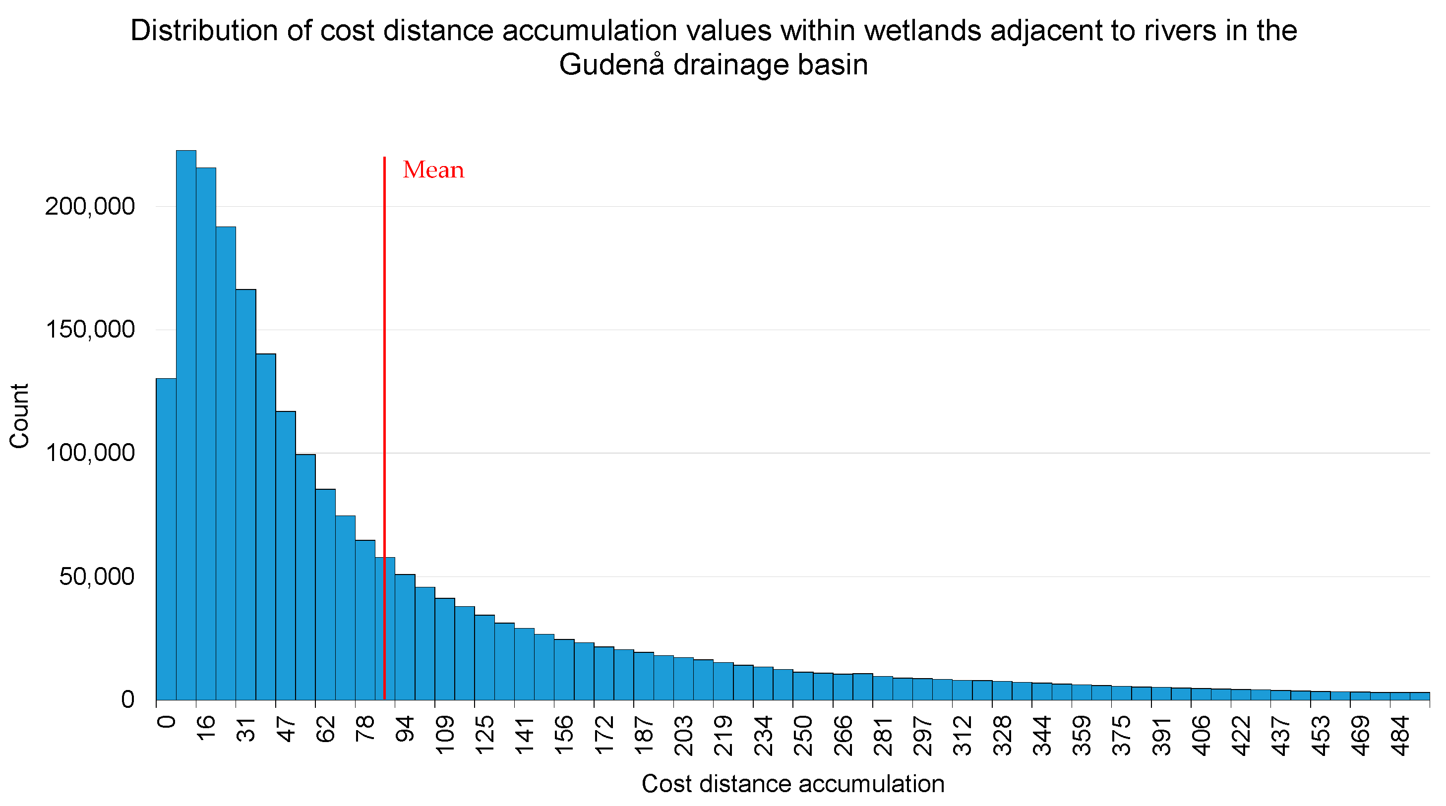
3.1. Cost Distance Accumulation
3.2. A Stepwise GIS Approach
4. Results
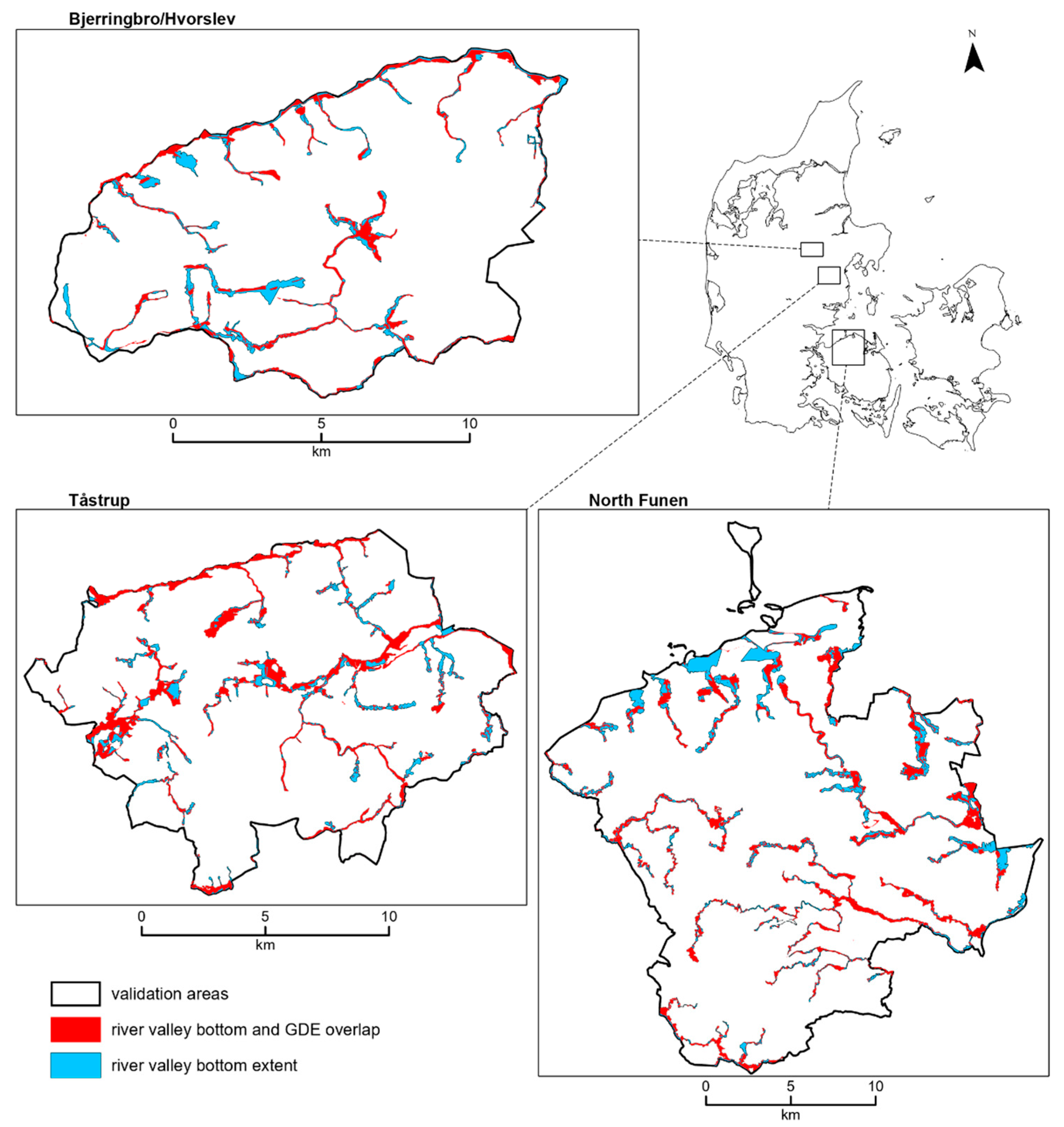
4.1. River Valley Bottom Map of Denmark
4.2. Validation
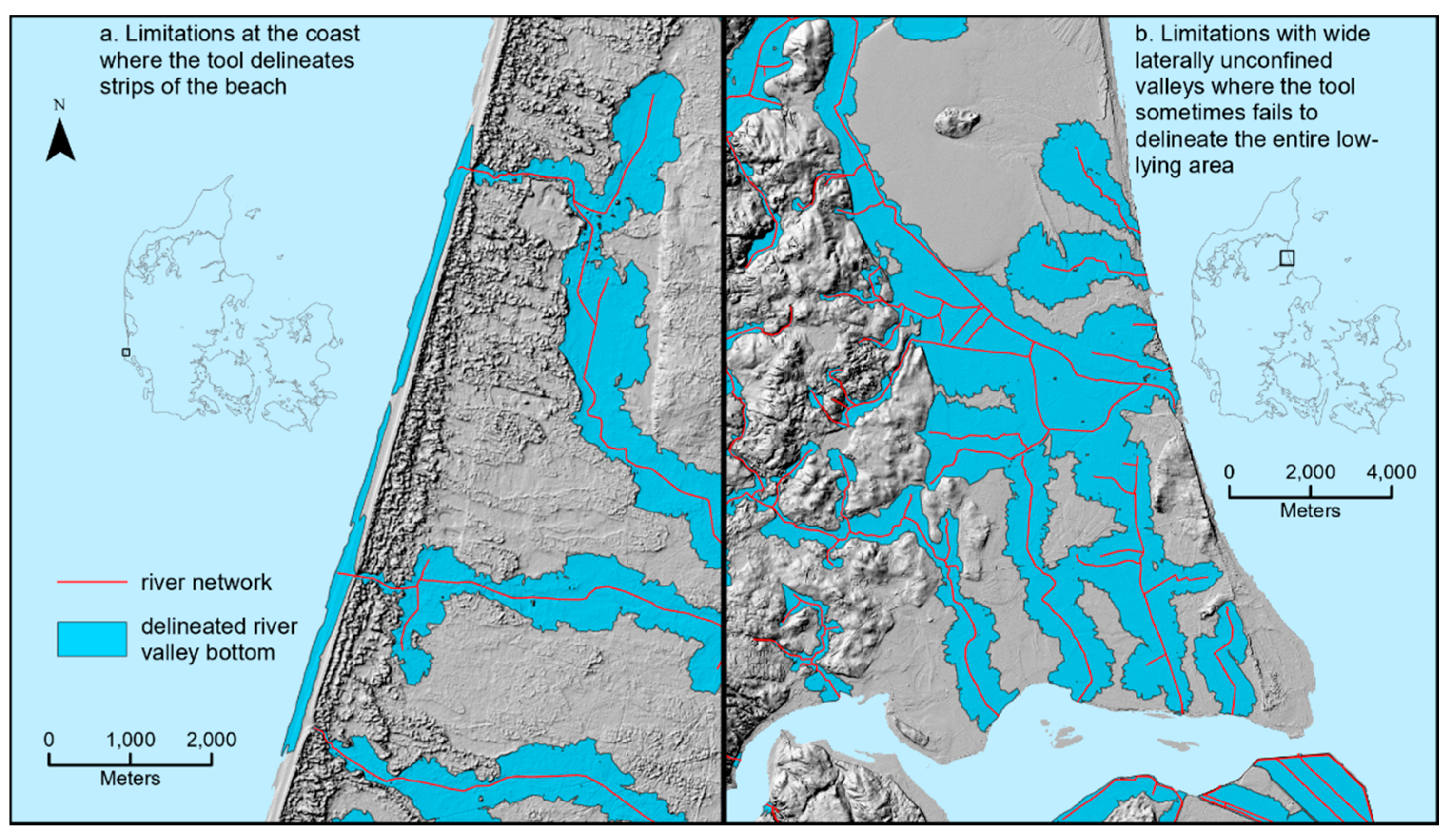
5. Discussion
6. Conclusions
Author Contributions
Funding
Institutional Review Board Statement
Informed Consent Statement
Data Availability Statement
Acknowledgments
Conflicts of Interest
References
- Chowdary, V.M.; Ramakrishnan, D.; Srivastava, Y.K.; Chandran, V.; Jeyaram, A. Integrated Water Resource Development Plan for Sustainable Management of Mayurakshi Watershed, India using Remote Sensing and GIS. Water Resour. Manag. 2009, 23, 1581–1602. [Google Scholar] [CrossRef]
- Langhoff, J.H.; Rasmussen, K.R.; Christensen, S. Quantification and regionalization of groundwater-surface water interaction along an alluvial stream. J. Hydrol. 2006, 320, 342–358. [Google Scholar] [CrossRef]
- Dahl, M.; Nilsson, B.; Langhoff, J.H.; Refsgaard, J.C. Review of classification systems and new multi-scale typology of groundwater-surface water interaction. J. Hydrol. 2007, 344, 1–16. [Google Scholar] [CrossRef]
- McGraw-Hill. Dictionary of Earth Science, 2nd ed.; McGraw-Hill: New York, NY, USA, 2003; p. 468. [Google Scholar]
- Gallant, J.C.; Dowling, T.I. A multiresolution index of valley bottom flatness for mapping depositional areas. Water Resour. Res. 2003, 39. [Google Scholar] [CrossRef]
- Hynes, H.B.N. The stream and its valley. SIL Proc. 1922–2010 1975, 19, 1–15. [Google Scholar] [CrossRef]
- Nardi, F.; Vivoni, E.R.; Grimaldi, S. Investigating a floodplain scaling relation using a hydrogeomorphic delineation method. Water Resour. Res. 2006, 42. [Google Scholar] [CrossRef]
- Fryirs, K.A.; Wheaton, J.M.; Brierley, G.J. An approach for measuring confinement and assessing the influence of valley setting on river forms and processes. Earth Surf. Proc. Land. 2016, 41, 701–710. [Google Scholar] [CrossRef]
- Wheaton, J.M.; Fryirs, K.A.; Brierley, G.; Bangen, S.G.; Bouwes, N.; O’Brien, G. Geomorphic mapping and taxonomy of fluvial landforms. Geomorphology 2015, 248, 273–295. [Google Scholar] [CrossRef]
- Brierley, G.; Fryirs, K. Geomorphology and River Management: Applications of the River Styles Framework; John Wiley & Sons: Hoboken, NJ, USA, 2005. [Google Scholar]
- Roberts, M.C.; Rood, K.M. The Role of the Ice Contributing Area in the Morphology of Transverse Fjords, British-Columbia. Geogr. Ann. Ser. A Phys. Geogr. 1984, 66, 381–393. [Google Scholar] [CrossRef]
- Clayton, K. Quantification of the impact of glacial erosion on the British Isles. Trans. Inst. Br. Geogr. 1996, 21, 124–140. [Google Scholar] [CrossRef]
- Hallet, B.; Hunter, L.; Bogen, J. Rates of erosion and sediment evacuation by glaciers: A review of field data and their implications. Glob. Planet. Chang. 1996, 12, 213–235. [Google Scholar] [CrossRef]
- Kirkbride, M.; Mathews, D. The role of fluvial and glacial erosion in landscape evolution: The Ben Ohau Range, New Zealand. Earth Surf. Proc. Land. 1997, 22, 317–327. [Google Scholar] [CrossRef]
- Montgomery, D.R. Valley formation by fluvial and glacial erosion. Geology 2002, 30, 1047–1050. [Google Scholar] [CrossRef]
- Hicks, D.M.; Mcsaveney, M.J.; Chinn, T.J.H. Sedimentation in Proglacial Ivory Lake, Southern Alps, New-Zealand. Arct. Alp. Res. 1990, 22, 26–42. [Google Scholar] [CrossRef]
- Summerfield, M.A.; Kirkbride, M.P. Climate and Landscape Response. Nature 1992, 355, 306. [Google Scholar] [CrossRef]
- Hebdon, N.J.; Atkinson, T.C.; Lawson, T.J.; Young, I.R. Rate of glacial valley deepening during the late Quaternary in Assynt, Scotland. Earth Surf. Proc. Land. 1997, 22, 307–315. [Google Scholar] [CrossRef]
- Lidmar-Bergstrom, K. A long-term perspective on glacial erosion. Earth Surf. Proc. Land. 1997, 22, 297–306. [Google Scholar] [CrossRef]
- Gilbert, J.T.; Macfarlane, W.W.; Wheaton, J.M. The Valley Bottom Extraction Tool (V-BET): A GIS tool for delineating valley bottoms across entire drainage networks. Comput. Geosci. 2016, 97, 1–14. [Google Scholar] [CrossRef]
- Dilts, T.E.; Yang, J.; Weisberg, P.J. Mapping Riparian Vegetation with Lidar Data; ArcUser Online: Redlands, CA, USA, 2010; pp. 18–21. [Google Scholar]
- McKean, J.; Nagel, D.; Tonina, D.; Bailey, P.; Wright, C.W.; Bohn, C.; Nayegandhi, A. Remote Sensing of Channels and Riparian Zones with a Narrow-Beam Aquatic-Terrestrial LIDAR. Remote Sens. 2009, 1, 1065–1096. [Google Scholar] [CrossRef]
- Roux, C.; Alber, A.; Bertrand, M.; Vaudor, L.; Piegay, H. “Fluvial Corridor”: A new ArcGIS toolbox package for multiscale riverscape exploration. Geomorphology 2015, 242, 29–37. [Google Scholar] [CrossRef]
- Burby, R.J.; French, S.P. Coping with Floods—the Land-Use Management Paradox. J. Am. Plann. Assoc. 1981, 47, 289–300. [Google Scholar] [CrossRef]
- Mount, J.F. California Rivers and Streams: The Conflict between Fluvial Process and Land Use; Univ of California Press: Berkeley, CA, USA, 1995. [Google Scholar]
- Ovesen, N.B.; Iversen, H.L.; Larsen, S.E.; Müller-Wohlfeil, D.-I.; Svendsen, L.M. Afstrømningsforhold i Danske Vandløb; Danish Centre For Environment And Energy: Roskilde, Denmark, 2000. [Google Scholar]
- Pedersen, S.A.S.; Huuse, M.; Redfern, J.; Heron, D.P.L.; Dixon, R.J.; Moscariello, A.; Craig, J. Glaciodynamic sequence stratigraphy. In Glaciogenic Reservoirs and Hydrocarbon Systems; Geological Society of London: London, UK, 2012; Volume 368. [Google Scholar]
- Houmark-Nielsen, M. Chapter 5—Pleistocene Glaciations in Denmark: A Closer Look at Chronology, Ice Dynamics and Landforms. In Developments in Quaternary Sciences; Ehlers, J., Gibbard, P.L., Hughes, P.D., Eds.; Elsevier: Amsterdam, The Netherlands, 2011; Volume 15, pp. 47–58. [Google Scholar]
- Breuning-Madsen, H.; Jensen, N.H.; Jakobsen, B.H.; Platou, S.W. Okkerkortlægning: Potentielt Svovlsure Jorder i Jylland; Department of Geosciences and Natural Resource Management, University of Copenhagen: Copenhagen, Denmark, 1984. [Google Scholar]
- Nilsson, B.; Wiese, M.B.; Tougaard, L.; Højberg, A.L.; Troldborg, L.; Greve, M.H.; Greve, M.B.; Tind, S.L. Forstudium til Vurdering af Udbredelse og Påvirkning af Grundvandsafhængige Terrestriske Økosystemer i Det Udrænede og Drænede Landskab; Geological Survey of Denmark and Greenland: Copenhagen, Denmark, 2014. [Google Scholar]
- CIS. CIS Technical Report No. 8. Technical Report on Methodologies Used for Assessing Groundwater Dependent Terrestrial Ecosystems; CIS Technical Report No. 2014-081; Publications Office of the EU: Luxembourg, 2014. [Google Scholar]
- Murphy, P.N.C.; Ogilvie, J.; Arp, P. Topographic modelling of soil moisture conditions: A comparison and verification of two models. Eur. J. Soil Sci. 2009, 60, 94–109. [Google Scholar] [CrossRef]
- White, B.; Ogilvie, J.; Campbell, D.M.H.; Hiltz, D.; Gauthier, B.; Chisholm, H.K.; Wen, H.K.; Murphy, P.N.C.; Arp, P.A. Using the Cartographic Depth-to-Water Index to Locate Small Streams and Associated Wet Areas across Landscapes. Can. Water Resour. J. 2012, 37, 333–347. [Google Scholar] [CrossRef]
- Agren, A.M.; Lidberg, W.; Stromgren, M.; Ogilvie, J.; Arp, P.A. Evaluating digital terrain indices for soil wetness mapping—A Swedish case study. Hydrol. Earth Syst. Sci. 2014, 18, 3623–3634. [Google Scholar] [CrossRef]
- Lidberg, W.; Nilsson, M.; Agren, A. Using machine learning to generate high-resolution wet area maps for planning forest management: A study in a boreal forest landscape. Ambio 2020, 49, 475–486. [Google Scholar] [CrossRef]


| Tool | Data Requirements | Algorithm | Reference |
|---|---|---|---|
| (1) Height Above River (HAR) | DEM and stream network | Flooding | [21] |
| (2) River Bathymetry Toolkit (RBT) | DEM | Flooding | [22] |
| (3) Multi-resolution Valley Bottom Flatness (MRVBF) | DEM | Slope | [5] |
| (4) Fluvial Corridor Toolbox | DEM | Slope | [23] |
| (5) Valley Bottom Extraction Toolbox (V-BET) | DEM and stream network | Slope | [20] |
| Area | Valley Bottom and GDE Intersection (km2) | Valley Bottom Extent (km2) | Overlap (%) |
|---|---|---|---|
| Bjerringbro/Hvorslev | 5.2 | 9.5 | 55 |
| Tåstrup | 10.6 | 15.7 | 67 |
| North Funen | 24.2 | 43.9 | 55 |
Publisher’s Note: MDPI stays neutral with regard to jurisdictional claims in published maps and institutional affiliations. |
© 2021 by the authors. Licensee MDPI, Basel, Switzerland. This article is an open access article distributed under the terms and conditions of the Creative Commons Attribution (CC BY) license (http://creativecommons.org/licenses/by/4.0/).
Share and Cite
Sechu, G.L.; Nilsson, B.; Iversen, B.V.; Greve, M.B.; Børgesen, C.D.; Greve, M.H. A Stepwise GIS Approach for the Delineation of River Valley Bottom within Drainage Basins Using a Cost Distance Accumulation Analysis. Water 2021, 13, 827. https://doi.org/10.3390/w13060827
Sechu GL, Nilsson B, Iversen BV, Greve MB, Børgesen CD, Greve MH. A Stepwise GIS Approach for the Delineation of River Valley Bottom within Drainage Basins Using a Cost Distance Accumulation Analysis. Water. 2021; 13(6):827. https://doi.org/10.3390/w13060827
Chicago/Turabian StyleSechu, Gasper L., Bertel Nilsson, Bo V. Iversen, Mette B. Greve, Christen D. Børgesen, and Mogens H. Greve. 2021. "A Stepwise GIS Approach for the Delineation of River Valley Bottom within Drainage Basins Using a Cost Distance Accumulation Analysis" Water 13, no. 6: 827. https://doi.org/10.3390/w13060827
APA StyleSechu, G. L., Nilsson, B., Iversen, B. V., Greve, M. B., Børgesen, C. D., & Greve, M. H. (2021). A Stepwise GIS Approach for the Delineation of River Valley Bottom within Drainage Basins Using a Cost Distance Accumulation Analysis. Water, 13(6), 827. https://doi.org/10.3390/w13060827