Article

Downstream State and Water Security in the Mekong Region: A Case of Cambodia between Too Much and Too Little Water

Faculty of Development Studies, Royal University of Phnom Penh, Phnom Penh 12156, Cambodia
Water 2021, 13(6), 802; https://doi.org/10.3390/w13060802
Submission received: 29 December 2020 / Revised: 23 February 2021 / Accepted: 1 March 2021 / Published: 15 March 2021
(This article belongs to the Special Issue Managing Climate Risks to Water Security)

Abstract

:
Cambodia has too much water during the wet season, and too little water remains in the dry season, which drives a relentless cycle of floods and droughts. These extremes destroy crops, properties, infrastructure, and lives and contribute to poverty. Thus, water management is key to the development of Cambodia. This article seeks to answer the question why Cambodia is vulnerable to floods and drought and how these conditions undermine the country’s development. It also examines what can be done to improve the country’s water resource management and the livelihoods of its population. The article examines water resource availability in Cambodia, its management regimes, and the policy implications in answering these research questions. The article looks at three case studies: first, the Stung Chreybak irrigation scheme in the Tonle Sap region; second, the Lower Sesan 2 Dam (LS2) in the Sesan, Srepok, and Sekong (3S) basin in Cambodia; and third, the transboundary water management in the Mekong Delta. It concludes that water management has been equated to irrigation management. However, the irrigation system in Cambodia has been inadequate to cope with the tremendous volume of water. Furthermore, water management has been complicated by the hydropower dams in the Upper Mekong region and the rubber dams in Vietnam’s Mekong Delta. These contribute to high water insecurity in Cambodia.

1. Introduction

Cambodia has too much water during the wet season, and too little water remains in the dry season, which drives a relentless cycle of floods and droughts. These extremes have destroyed crops, properties, infrastructure, and lives. In addition to earlier periods of conflict, these conditions have contributed to poverty. This article seeks to answer the question why Cambodia is so vulnerable to flood and drought and how these conditions undermine the country’s development. It also examines what can be done to improve the country’s water resource management and the livelihoods of the population. In answering these questions, the article examines water resource availability in Cambodia, its management regimes, and the external implications. In doing so, the article analyzes three case studies: first, the Stung Chreybak irrigation scheme in the Tonle Sap region; second, the Lower Sesan 2 Dam (LS2) in the Sesan, Srepok, and Sekong (3S) basin in Cambodia; and third, the transboundary water management in the Mekong Delta.
The too much water could be referred to as a flood, while little water to water scarcity could be referred to as drought. Floods and water scarcity are two forms of water insecurity. Water security is defined as the reliable availability of an acceptable quantity and quality of water for health, livelihoods, and production, coupled with an acceptable level of water-related risks [1]. The United Nation (UN) (2013) [2] defines water security as “the capacity of a population to safeguard sustainable access to adequate quantities of acceptable quality water for sustaining livelihoods, human well-being, and socio-economic development, for ensuring protection against water-borne pollution and water-related disasters, and for preserving ecosystems in a climate of peace and political stability” Water security underlies all dimensions of human health and people’s well-being and is fundamental to food and energy production [3].
This paper takes the conceptual discussion above to analyze water security in Cambodia. Floods and droughts have led to water security issues in many parts of Cambodia. However, it is beyond the scope of this study to understand water security across the entire country.

2. General Context and Literature Review

A bulk of the literature discusses water security concerning humans and society. Jepson et al. [4] argue that society depends on water for human survival. Water is essential for agriculture, energy production, transportation, and many other activities, which sustain human life. Humans build societies, spaces, and places in association with water availability, and so cultures and practices are created as a result of human interaction with water and hydrology. On the other hand, water and hydrology shape society, culture, lifestyle, and the social process, such as a floating life in the Tonle Sap Lake [5]. As the hydrological regime and physical flows change, it changes the culture and social process. Thus, water security is related to hydrological and social processes [4]. Not only humans but also ecosystems rely on water. They rapidly deteriorate in the absence of water, thus endangering many livelihoods and resources they provide [1,3,6].
There are two schools of thought concerning water security. First, it concerns the physical water availability in quantity and quality and its safe uses for livelihoods, health, economic production, and ecosystems. A handful of studies from this school of thought discuss the physical availability of water; water use for household consumption, economic production, and ecosystems; the scales of water use (household, nation-state, river basin); and the different drivers that influence water use, such as climate change, armed conflict, and economic growth. They also identify the solutions to water problems through building water storage, water infrastructure, water supply technologies, and policy reform [1,2,4,6]. The second school of thought concerns the interstate conflicts or water wars over the shares of water from the international river basin [7,8,9].
At present, however, water resources are under pressure due to an increasing population, urbanization, industrialization, land-use changes, natural disasters, and climate change. These have affected the availability, access, and safe use of water resources. Falkenmark et al. [10] in 1989 came up with a method of measuring water scarcity based on the per capita annual renewable freshwater available, and they define the region with less than 1000 m3 per capita per year as being water insecure. Moreover, some countries have a high water per capita per year but still face water scarcity. These are countries in sub-Saharan Africa, where renewable water resources per capita are 1700 m3 per year. Despite this, these countries remain water insecure, as water cannot be restored for their use, given the lack of water infrastructures; thus, their population is at risk because they have very little access to and control over water. In 2009, the Water Resources Vulnerability Index was developed to measure water security. the index is defined as the ratio of total annual withdrawals to available water resources. A country is defined as being water scarce if the ratio of water withdrawal to water availability exceeds 40% [11]. Furthermore, the International Water Management Institute (IWMI) introduced the concept of economic water scarcity, through which a country develops an infrastructure for improving water management. A country is defined as water secure if less than 25% of the water from the river is withdrawn for human purposes and where there is a significant improvement in the water infrastructure to meet human needs [12,13].
Floods are another form of water security issue. Floods can be defined as a temporary covering of land by water outside its normal confines. Flooding is a natural phenomenon. A natural flood cannot be considered a threat, as in the Tonle Sap Lake and the Mekong floodplain. However, floods in intensively used catchments are often influenced by people through land use, river changing, etc. [14]. Floods can also occur in a river when the flow rate exceeds the capacity of a river channel. Elements exposed to floods could be harmed. However, damages by floods depend on the vulnerability of the exposed elements. Three basic areas of flood vulnerabilities can be distinguished: social and cultural, economic, and ecological vulnerabilities. Social and cultural vulnerabilities refer to the loss of life, health impacts (injuries), loss of vitality, stress, social impact, loss of personal articles, and loss of cultural heritage. Economic vulnerability alludes to direct and indirect financial losses by damage to property assets, basic materials and goods, reduced productivity, and relief efforts. Ecological vulnerability comprises anthropogenic pollution of waters, soils, and ecological systems with their biota [15] Krause [16] studied the frequent and low-intensity flooding in Gloucestershire, UK, and argues that frequent floods result in increased preparedness and reduced vulnerability. In the city of Dresden in Germany, people implemented flood protection measures after the flood in 2002, such as raising the embankment and implementing a dike system to control floods. Kreibich and Thieken [17] noted that flood protection reduced vulnerability during the 2005/2006 floods. Indeed, structural protections against flood can have perverse effects such as increasing vulnerability by forgetting the risk, and so urbanization goes on or even increases in flood-prone areas, or by putting people at a new risk [15]. Van Koningsveld et al. [18] examined the interactions between floods and people that have shaped Dutch society, its institutions, and its flood protection system over the centuries, and found out that the Dutch human–flood system is shifting from coping strategies to protection strategies [18]. In the context of climate change, the adaptation registry is becoming increasingly important. In terms of flood risk, the promotion of adaptation and the resilience of territories and societies question the protection and primacy of structural measures [18]. Central to these continuous interactions of humans and floods is the attempt of humans to minimize flood risk. Since flood risk is the combined effect of hazard, exposure, and vulnerability, humans attempt to alter one or more of these factors. Changes in technology have affected the flooding regime in the Yellow River. The siltation of reservoirs during floods has affected society [19].
Thus, the degree of water security depends on the capacity of the society and ecosystem to respond to water insecurities through building infrastructures and investing in technologies to make water available and accessible for health, livelihoods, ecosystems, and productive economies [6]. On the other hand, societies and ecosystems can adapt and build resilience to the changing water quantity and quality and safe use [20]. In addition, according to Jepson et al. [4], water security concerns “securing the ability to engage with and benefit from the sustainable hydro-social process that supports water flows, water quality, and water services in supports of human capacities and well-being” [4].
Another school of thought concerns international river basin management and the conflict between riparian states that could cause water wars. Among 261 international river basins worldwide, water and other riparian resources from one river basin could be shared by two or more countries. An international river may be managed for multiple uses such as hydropower development, food production, industrial development, municipal water supplies, recreation, or a combination of all these. Different user groups in riparian countries often have difficulty reaching an agreement on the equitable sharing of water resources between upstream and downstream states [7]. The increasing competition for limited freshwater resources along international rivers could escalate interstate conflicts. Water conflicts can be related to water quality, quantity, and ecosystem issues [8,9]. These developments would lead to political tensions and even armed conflicts, as in the 1967 war that took place over the water between Israel and Arab states in the Jordan River. World Bank President Ismail Serageld in 1995 stated this would lead to a water war in the 21st century [8,9,10].
Hence, rather than going to war over water, co-riparian states often choose to cooperate and share river resources and benefits. Globally, Wolf [7] found no water wars within the 261 international river basins across the globe. In the Mekong River basin, many studies have identified no major conflict, and riparian states cooperate to manage and share benefits from the Mekong River, despite interstate tensions because of the building of large-scale hydropower dams [21,22].

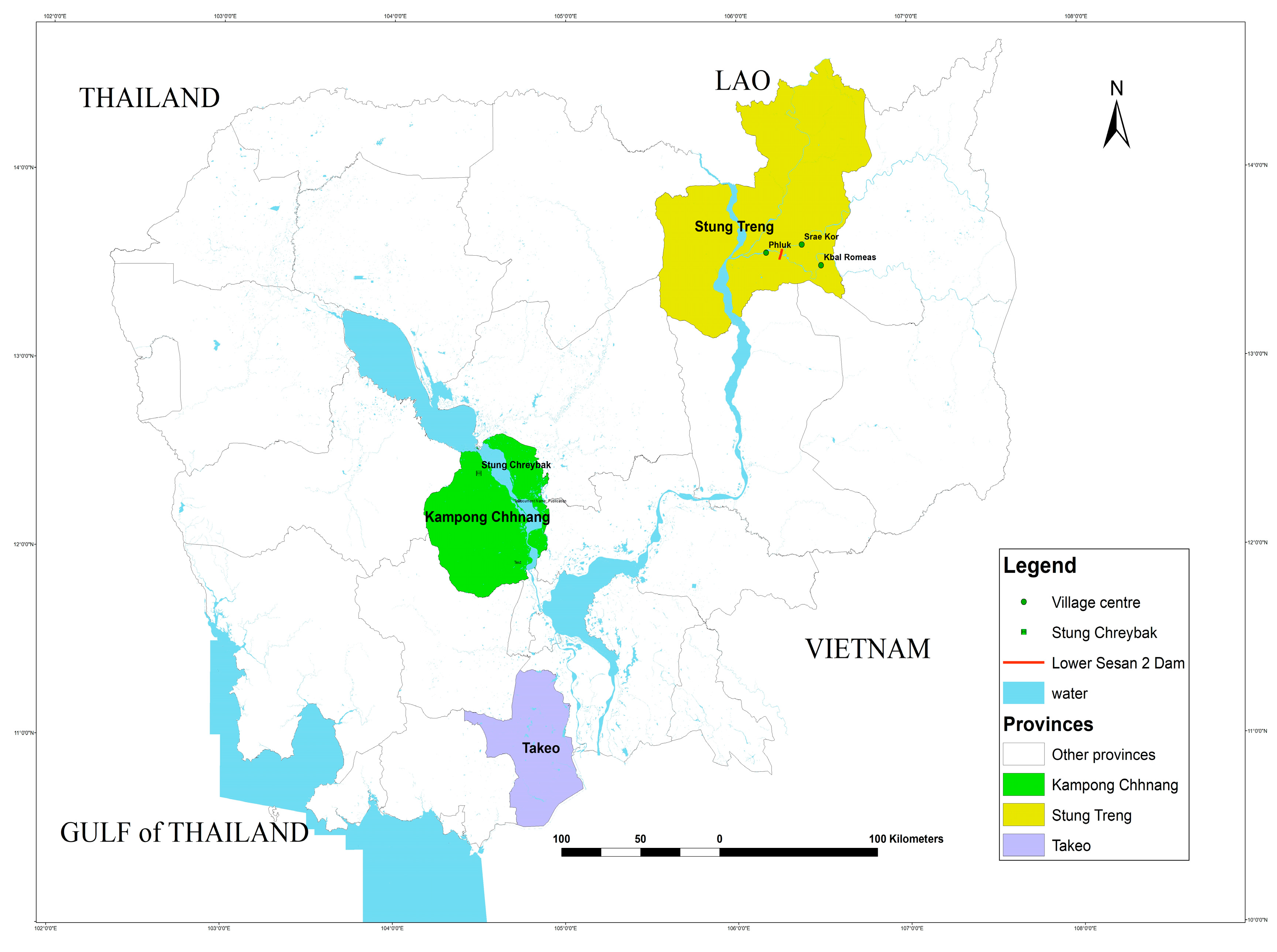
3. Materials and Methods

The paper focuses on areas where critical water issues, particularly the problem of too much or too little water, affect the livelihood security of rural communities and risk impairing the functioning and sustainability of ecosystem services. Three case studies in three specific regions in Cambodia were selected to look at water security (Table 1): a case study on the Lower Sean 2 dam (LS2) 3S region in Cambodia, a second case study on the transboundary water management in the Mekong Delta, and a third case study on the Stung Chreybak irrigation scheme in the Tonle Sap Lake.
The Sesan, Srepok, and Sekong (3S) river basin is the largest tributary of the Mekong River (Figure 1), covering 78,579 km2, about 10% of the Mekong River basin, and spanning over the three countries of Laos (29%percent), Cambodia (33%), and Vietnam (38%) [23]. These rivers flow from Vietnam and Laos to Cambodia and meet the Mekong River at Stung Treng. In the 3S basin, Vietnam built 15 hydropower dams, Cambodia built two dams, and Laos built one dam. The case study looked at the hydropower dam and selected the Lower Sesan 2 Dam (LS2) for a detailed investigation of how the hydropower dam contributed to water security. The empirical study was undertaken between January and May 2017, and it looked at how hydropower dams have affected the water and livelihood security of local communities. The research selected two villages for detailed studies, namely Srae Kor and Kbal Romeas. The researcher organized two focused group discussions (FGDs), one in Srae Kor and one in Kbal Romeas with five and seven villagers, respectively. The researcher also interviewed 10 representatives of the provincial government and provincial departments, including agriculture, fisheries, environment, water resources, rural development, energy, women and education, and district authority. The researcher asked essential questions, including the impacts of the LS2 on the river system, livelihoods of river-dependent people, fisheries and water resources, flood and drought events, local government involvement in addressing villager concerns, and the intervention of the national government.
The Tonle Sap region is located in the center of Cambodia. It consists of the largest freshwater lake, known as the Tonle Sap Lake, surrounded by a floodplain, rice fields, and sub-river basins. Around the lake, many irrigation schemes were built and operated. Stung Chreybak irrigation is one of these schemes, located in the West Tonle Sap region in Kampong Chhnang Province, that can irrigate 10,367 ha of farmlands in 15 villages in two districts (Tukpos and Rolea Phier). It was selected for a detailed study of how it contributes to water security. Empirical studies were conducted between July and September 2016 to collect both primary and secondary data. The researcher gathered data from semi-structured interviews with stakeholders at the national and community levels and through two focus group discussions (FGDs) in the Chreybak and Trapang Trabek communities in Kampong Chhnang Province. The researcher asked questions related to the scheme operations, management, sharing of benefits, and drought and flooding issues. In total, the researcher interviewed 10 people drawn from the United Nations Development Program (UNDP), Asian Development Bank (ADB), NGOs in Cambodia, national and local government agencies, and community representatives. The interviews focused on the water management activities and programs run by each organization, the policies and legal frameworks in place to support these activities, the capacity of each organization to address water management issues, the level of participation among local communities and stakeholders, and the challenges and opportunities that exist in improving water management in the study areas. FGDs were held in Chreybak and Trapang Trabek communities, and members of the Farmer Water User Communities (FWUCs), village chiefs, and commune councilors participated. The FGDs focused on the roles of the FWUCs, management, and the use of water. At Phnom Penh, the Mekong River splits into two rivers—the Bassac and Mekong Rivers. The Bassac River flows from Cambodia to Vietnam over a distance of 190km. Transboundary water management in the Bassac River basin between Cambodia and Vietnam has been critical, and flood and drought have caused a water security issue in Cambodia. Thus, the researcher selected transboundary water management in the Mekong Delta as a case study to examine the water security issues in Cambodia. The empirical study was conducted between March and December 2015. The researcher undertook this work under the Mekong River Commission (MRC) project of improving transboundary river management in the Lower Mekong River basin between Cambodia and Vietnam, funded by the World Bank. The study relied on secondary and primary data, collected using structured and semi-structured interviews held with stakeholders in Takeo Province and a focus group discussion (FGD) with officials and community representatives from along the border with Vietnam in Takeo Province. The study interviewed 10 officers at the provincial level, including representatives from the Provincial Department of Water Resources and Meteorology, agriculture, rural development, fisheries, women development, the district officer, the commune chief, and members of FWUCs. Two focus group discussions were conducted, with three to five people participating in each, including members of the commune councils, village chiefs, and members of FWUCs. The researcher questioned interviewees on problems of flooding, droughts, transboundary water management challenges, the capacities of government agencies and communities to address water management issues, and the participation of local communities and stakeholders to respond to water security issues.
Both qualitative and quantitative analytical approaches were employed to analyze the collected primary and secondary data. The qualitative and quantitative data were analyzed based on the information generated from the FGDs, the three case studies, the history of water governance issues in Cambodia, the legal and institutional frameworks, the performance and management of water issues, and the challenges and opportunities for improving water governance. Given the small sample size, the researcher used Excel to analyze quantitative data. The data were entered into Excel sheets and processed into percentages, figures, and tables. These percentages, tables, and figures were supported by qualitative information.

4. Results and Discussion

4.1. Water Resources in Cambodia

Cambodia covers an area of 181,035 km2. About 86% (156,000 km2) of Cambodian territory falls in the Mekong catchments. Geographically, Cambodia is a lowland and downstream country in the Mekong River basin (MRB). Hence, Cambodia has abundant water resources. About 120.6 km3 of water comes from within the Cambodian territory, and another 355.5km3 flows from outside via the Mekong River. The total renewable water resources (TRWR) in Cambodia are estimated at 476 km3 annually. The TRWR per capita in Cambodia is estimated at 30,352km3. These data suggest that Cambodia has abundant water resources (Table 2).
Only a small proportion of water resources flowing through Cambodia are used. About 2 million m3 of water is used in Cambodia each year, with agriculture being the largest user, accounting for 94% of usage. Irrigation water withdrawal consumes an estimated 1,928,000 m3 annually. The rest of the water is used for domestic and industrial applications. The total amount of water withdrawal per capita is estimated at 159 m3/year.
The internal water resources of Cambodia originate from five main river basins. These include: (1) the Tonle Sap River basin, (2) the Upper Mekong River basin, (3) the 3S river basin, (4) the Mekong Delta, and (5) the coastal river basin. The Tonle Sap River basin comprises 16 sub-river basins, the Upper Mekong River basin has 5 sub-river basins, the 3S basin has 3 sub-river basins, the Mekong Delta has 8 sub-river basins, and the coastal river basin has 8 sub-river basins. These rivers and sub-rivers provide abundant water resources for Cambodia. The Mekong River is the source of external water resources flowing into Cambodia and then to the South China Sea, providing Cambodia with abundant water resources. The abundant water resources can be too much sometimes, causing flooding in the wet season, but these waters discharge into the sea, emptying many canals and rivers, causing drought in Cambodia.
The researcher undertook three case studies in three different regions to study water security, particularly floods and droughts, how it has affected Cambodia’s development, and what can be done to improve it. Table 3 presents the summaries and the detailed characteristics of the three case studies concerning water security.

4.2. Water Management in Cambodia

Cambodia has a diverse range of freshwater sources, including rivers, streams, and lakes, most of which are designated as state property. The effective management of such water is key to the development of Cambodia. However, water management in Cambodia has long been dominated by a centralized management system [25,26]. The centralized water management in Cambodia is devoted to the development and management of irrigation systems. In this regard, water management has been equated at large to irrigation development and management.
There are over 2525 irrigation schemes in Cambodia, categorized into small (50 to 200 ha), medium (200 to 5,000 ha), and large (>5,000 ha) scale. There are a total of 47 large-, 1243 medium-, and 1254 small-scale schemes [27]. These correspond to a total annual irrigated area of some 498,200 ha for large-scale, 931,900 ha for medium-scale, and 131,290 ha for small-scale schemes, giving a total irrigated area of 1,561,390 ha. Of the total number of irrigation schemes, about 1926 of them have potential for rehabilitation [27].
Of the 2525 schemes, only 6% function well, 32% function partially, and 62% do not function as intended. More than 2400 irrigated systems need rehabilitation or reconstruction [28]. Anyhow, irrigation in Cambodia could take annually only 1.928 km3/year. These are a relatively small proportion of irrigation schemes that could take water from large volumes of total renewable water resources.
Among many functional irrigation schemes, the researcher picked up the Stung Chreybak irrigation scheme to study the efficiency and effectiveness of managing the too much and too little water. The Stung Chrey Bak catchment covers approximately 790 km2 and follows the Stung Chrey Bak River. Its headwater originates in the Chrieve Mountain in the west of Kampong Chhnang Province. The river then flows eastward approximately 76 km toward the Tonle Sap Lake.
Khmer Rouge built the Stung Chreybak irrigation scheme in 1976. After the Khmer Rouge, this scheme was dysfunctional and unused, and large parts of the canal system were damaged as a result of a lack of management and maintenance. In 1985, an NGO known as the American Friend Service Committee (AFSC) took initiatives to rehabilitate the Stung Chreybak irrigation scheme, supplying water to irrigate large farming areas in the downstream part of the Stung Chreybak basin. Furthermore, in 2001, the Stung Chreybak irrigation schemewas again rehabilitated by the EU Support Program known as the PRASAC.
This scheme could irrigate 10,367 ha, and 15 villages in two districts—Tukpos and Rolear Phier—in Kampong Chhnang Province benefit from this scheme. The scheme is structured into seven sub-schemes, most of the sub-themes were designed for both wet and dry-season rice, and only two sub-schemes were only for wet-season rice. The whole scheme irrigates 9626 ha of wet-season rice and 741 ha of dry-season rice (Table 4).
In the wet season, from May to October, water is abundant in the scheme and sub-schemes. The upper sub-schemes release water downstream and flood the downstream schemes, particularly in Chreybak and Trapaing Trabek communities. Water discharges gradually increase from May, peak at 270 million cubic meters (MCM) in September, fall from October to December, and then level out until April. Annually, the Stung Chreybak River discharges totally about 289 MCM to the Tonle Sap Lake. However, from January to April, there is not enough water, and thus, the upstream scheme retains water, leading to a shortage of water downstream.
Indeed, the scheme was designed and built to provide the wet-season supplementary irrigation only. As a result, this scheme does not retain water during the wet season for later uses in the dry season. Flawed designs concerning hydrological and geographical realities have also contributed to the existing scheme falling into disrepair, with failure already built into the design and occurring during construction. Despite its upgrade by the AFSC and PRASAC after the Khmer Rouge, it is still inefficient in dealing with too much water in the wet season and too little water in the dry season.
On the other hand, of the total water volume from the Stung Chreyback River (289 MCM), only about 90 MCM, or 31%, is used to irrigate the wet-season rice in seven irrigation schemes across the river basin. However, small farmlands (around one hectare per household) do not rely very much on irrigation schemes, as it should be, as they can use rainwater to irrigate their rice paddy. Nevertheless, using water from the irrigation canal such as Stung Chreybak will be a burden for small farmers, as they need to pump water using water pumps, which involves a fuel cost and other costs. Thus, many farmers choose to use rainwater water. The water volume of 90 MCM from seven sub-schemes of Stung Chreybak is not fully used, and so, it releases downstream to the Tonle Sap Lake.
Consequently, during the wet season, the sub-schemes open up the water gates to release water downstream, worrying about the collapse of the dikes. The water floods the downstream areas in Trapang Trabek and Chreybak areas heavily. From May to October, the water rises in the Tonle Sap Lake, and it flows into the Stung Chreybak River Basin in the downstream areas, flooding the Trepang Trabek and Chreyback areas, damaging crops and paddy rice. About 615 ha of paddy fields in Trapang Trabek and Chreyback communities, out of 1065 ha, are heavily flooded between May and October, and the wet-season rice cannot be cultivated during this period.
From October to December, floods start receding from the Trepang Trabek and Chreybak sub-schemes areas toward the Tonle Sap Lake. Farmers in Trapang Trabek, Chreybak, and Tang Krasan start cultivating the recession and dry-season rice, effective from October to December. About 741 ha of rice fields in these communities are cultivated with recession rice and dry-season rice, of which about 510 ha in the Trepang Trabek sub-scheme are irrigated using a large volume of water from the Tonle Sap River. However, four sub-schemes upstream, covering 3676 ha, face a drought and are not operational in the dry season, as they have no water. In addition, three sub-schemes downstream, covering 5950 ha, also experience severe drought.
The conflict between upstream and downstream areas happens every year during the drought period. Between 2000 and 2010, efforts were made to facilitate the conflicts between upstream and downstream communities by the Provincial Department of Water Resources. A Farmer Water User Community (FWUC) was established, which brought villagers together to negotiate water management in the Stung Chreybak irrigation scheme. It took a long time and great efforts to make the communities to communicate on sharing water and negotiating the procedures to open up the water gates and release water downstream. Despite that, the conflict remains unresolved. The irrigation system has been employed to manage water resources in the country. However, irrigation system management has been less compared to the volume of water flowing across the irrigation schemes and Cambodia in the wet season. However, irrigation systems across the country do not store water for dry-season uses. Therefore, Cambodia faces a water shortage in the dry season. The irrigation scheme does neither address water issues such as flood and drought, nor improves water for agriculture. Agriculture remains vulnerable to water shortages or floods. Thus, the country will continue to face too much water in the wet season and too little water in the dry season in the long run if water resource management is not adequately improved. In conclusion, the irrigation system has been employed to manage water resources in the country.

4.3. Hydropower Developments and Issues beyond Water Security

There is an assumption that dams can reduce flood events and increase the dry-season flow, which is essential for agriculture in the downstream region. It sounds promising for building more dams in the Mekong River basin. This section examines hydropower development in the Mekong River basin and assesses whether it contributes to improving water security in Cambodia in particular.
Indeed, between 1965 and 2005, 22 major dams were constructed in four lower Mekong countries, with active storage capacities of about 15,328 million cubic meters (MCM) [30]. After the 1990s, many hydropower dams were built in different countries in the Mekong region. China put into operation 65 water dams along the Lancang River and its tributaries. It planned to build 23 dams on the Lancang River [31]. Among the 23 planned dams, 11 mainstream dams were built between 1993 and 2020, with an electricity-generating capacity of 21,310 MW and a storage capacity of 47,644 MCM (Table 5).
Laos planned to build nine mainstream dams, and Cambodia planned two dams. Two mainstream hydropower dams in Laos were built (Xayabuiri and Don Sahong), and four more dams are under planning. In addition, 132 hydropower projects are being proposed, planned, and built on the tributaries in the lower Mekong River basin—25 hydropower dams are operational, 13 dams are under construction, 23 dams are licensed, and 74 dams are planned [30]. Some 42 hydropower dams have been planned and built in the 3S river basin—3 hydropower dams were built on the Sekong River, 8 on the Sesan River, and 7 on the Srepok River—and 23 hydropower dams are under planning [32].
The total water storage capacity of the Mekong River dams will reach 130 billion cubic meters in the future (Table 4). Between 1992 and 2019, China’s Mekong River dams held back and/ thus, made the water level in the Mekong River downstream area relatively low compared with the predicted level. However, hydropower dam operations have considerably altered the flow of the Mekong River, sometimes causing heavy floods. As a consequence, Cambodia has experienced frequent droughts and floods in the past two decades. The floods in 1996, 2000, and 2011 destroyed crops, livelihoods, houses, infrastructure, and roads worth thousands of dollars [33]. The floods in 2000 killed 350 people and caused US $ 150 million’s worth of damage to crops and infrastructure [34]. In 2011, a heavy flood killed 247 people and damaged property worth US$ 521 million, with 220,000 ha of rice fields destroyed [33]. Not only floods but also droughts occurred around the Tonle Sap Lake. The most severe droughts occurred in 2002 and 2012, which led to crop damages, a lack of food, and disease [35]. The drought in 2002 affected more than two million people and destroyed more than 100,000 ha of paddy fields [36]. The drought in 2012 devastated 9990 ha of paddy fields and affected 122,297 ha across the country. Floods accounted for 70% of rice production losses between 1998 and 2002, while droughts accounted for 20% losses, inducing significant food security [37].
From 2014 to 2015, Cambodia experienced a severe drought. The drought in Cambodia continued in 2016, and the Royal Government of Cambodia declared a state emergency due to a lack of water for human consumption. The Royal Government of Cambodia (RGC) took a step to distribute water to its populations across the country. In the Mekong Delta in Vietnam, more than two million Vietnamese and many of Vietnam’s rice production areas were impacted by low water levels and severe saline intrusion in 2016, resulting in over US $ 670 million of losses. In March 2016, China released water from its upstream dams to relieve the severe drought in Vietnam [38].
The drought continued in 2019–2020. The reverse flow from the Mekong River to the Tonle Sap Lake takes place from mid-May to mid-October. However, in 2019, the main reverse flow into the Tonle Sap Lake started in August. In 2020, the reverse flow of the Tonle Sap Lake started late on August 4. The delay in the reverse flow of water from the Mekong River to the Tonle Sap Lake happened due to the low water level in the Mekong River. The seasonal changes in the monthly flow volume up to August 31 for the Tonle Sap Lake compared with water volumes in 2018 and 2019 are significantly low. Also, in July and August 2020, the water volume in the lake was critical compared with the previous year (2019) and historical minimum levels in the same period. This reveals that the Tonle Sap Lake (TSL) is still affected by low inflows from the Mekong River and insufficient rainfall in the surrounding sub-catchments [39].
The LS2 is one of many hydropower projects in the Mekong region. It was chosen to study how hydropower dams contribute to water security issues. This dam was built by the Hydropower Lower Sesan 2, a joint venture between the subsidiary Hydrolancang International Energy (HIE) of China’s Huaneng Group, the Royal Group of Cambodia (RG), and the Electricity of Vietnam (EVN) to generate electricity, control floods, and increase the dry-season flow for agriculture. The HIE provided the largest share (51%) of the project’s costs, while the RG contributed 39%, and the EVN contributed 10% to the share [40]. The cost of building the LS2 was US$ 816 million [41]. It is located about 1.5 km downstream from where the Sesan River meets the Srepok River and 25 km from the confluence with the Mekong River mainstream. Clearing of the reservoir area for the LS2 began in March 2013. The construction of the LS2 started in February 2014 and was completed in 2017. Prime Minister Hun Sen presided over the ceremonial opening of the LS2 on 25 September 2017. At full capacity, the LS2 generates 400 MW of electricity. It is the first large dam on the Cambodian section of the 3S Rivers [42].
Dams in the 3S basin, including the LS2, have produced water security downstream of the Sesan and Srepok Rivers, and particularly in Srae Kor, Phluk, and Kbal Romeas communities, resulting in increased dry-season water flows, decreased wet-season flows, and also occasional heavy and unpredictable floods. All these events harm the local environment, as well as fisheries, biodiversity levels, and people. Indeed, the hydropower dam is not always operated to control floods, and often in the wet season, when the reservoir is full, water is released, leading to flooding downstream. Villagers confirmed that floods occurred almost every year since 1996, not necessarily caused by the LS2, but by other dams in Vietnam and Laos.
After the building of the LS2, water level fluctuations occurred between a half and one meter within a single day below the dam. The water level in the reservoir stays almost the same year-round, and the fish habitat in the reservoir is changing from a flowing river to a homogeneous flow reservoir, and this reduces the variability in the species and catchability so that there is no longer a seasonal difference in the fish catch. Thus, there seems no seasonality, only homogenizing water flow conditions, and fish stocks are not replenished, as there is no connectivity to the 3S and the Mekong River system. Thus, the reservoir acts as a sink to the fish, which over time will most likely reduce the diversity in the reservoir itself and the adjacent rivers. The study found that the fish size does not change from the peak season to the low season in the reservoir area, whereas the fish size changes in the area above and below the reservoir area. This is an indication of a lack of seasonality in the reservoir areas. Above the reservoir, water level fluctuations of between a half and one meter within a single day also occurred during the study period.
Villagers along the Sesan and Srepok Rivers refer to these abrupt and unpredictable fluctuations in the level of the Sesan River as Tonle-checkout or crazy river, and these events have continued in Srae Kor, Kbal Romeas, and Phluk since that time, causing damage to rice crops and property (personal communication with villagers, 15 to 18 May 2017). Following the construction of many hydropower dams along the Sesan and Srepok Rivers in Vietnam, dry-season flows at the confluence of the 3S rivers in Cambodia have increased by 28%, while wet-season flows have decreased by 4% [32]. As a result, the dry-season flows are sometimes comparable to the wet-season flows, a phenomenon described as homogenized flow. Thus, the increased dry-season flow has resulted in areas that used to be dry in the dry season and have become permanently inundated and in an area that used to be flooded in the wet season and has become dry, leading to reduced river productivity.
The construction of the LS2 has disrupted the river flow and the migration of fish within the 3S basin. It has also reduced the number of fish that could breed in the areas due to degraded habitats and fluctuating water levels. The LS2 has blocked fish migration routes upstream. No migratory fish species will be able to migrate past the dam onto the upstream tributaries of the Sesan and Srepok Rivers when it is operational. The 3S rivers are home to 329 fish species—133 species in Sesan, 213 species in Sekong, and 240 species in Srepok [43]. The LS2 has impacted fisheries, and fish catch would drop by 9.3% basin-wide, amounting to approximately 200,000 tons of fish each year [44]. The data collected by the Inland Fisheries Research and Development Institutes (IFReDI) in Cambodia as part of the MRC’s Fish Abundance and Diversity Monitoring Project in the 3S rivers from 2007 to 2014 for a pre-closure period of the LS2 and from May 2017 to April 2018 for the post-closure period of the LS2 [45] indicate the reduction in many fish species in the 3S rivers (Table 6).
The fish concentration varied between upstream and downstream of the LS2 and between the reservoir area and the river above it. About 75% of the interviewed villagers reported no sign of a fish reduction in the reservoir areas, as there is more water. However, they complained that the river area upstream of the old Srae Kor (Muoy and Pir) and Kbal Romeas villages were not rich in fish. About 25% of interviewed villagers reported no fish abundance below the LS2, particularly in the Phluk village.
Dams have also induced environmental security. This has an impact on forest resources alongside rivers, fish habitats, and the rivers’ ecosystems. The LS2 submerged 30,000ha of forestland, 1290ha of agricultural land, 218ha of grassland, and 47ha of bush forest, plus existing water bodies [42]. About 2003ha of community forest areas in the Srae Kor commune and 1307ha in the Kbal Romeas commune were also lost to the dam site. The LS2 also affected 10,399ha of economic and forest land concessions that the RGC previously granted to six private companies. About 150ha of spirit forest areas protected by communities, 35ha of graveyards, and about 65ha of ancestor domains were lost to the LS2, too. About 846 households lost their access to their community forest areas (personal communication with villagers, 15 to 18 May 2017).
Dams have also produced human security. The LS2 has affected 846 families in six villages. The affected populations were relocated to four different resettlement sites, covering 4000 ha. At the time of this study, about 85% of the affected families agreed to relocate to new resettlement sites, but 15% refused to leave their villages. The LS2 developer built infrastructures such as roads, markets, health centers, temples, schools, and houses to accommodate the relocated households affected by the LS2. Ethnic groups from affected villages, including Lao, Phnong, Prove, and Kreung, adapted to the new living environments of man-built structures. They switched from a cashless tradition to a rural-market-based community, where buying and selling have become common in everyday life. The free collection of water and fish from rivers, the non-timber forest products (NTFP) from forest areas, and agricultural products from paddy fields were replaced by paying to obtain them from a marketplace. In doing so, the villagers used their savings and cash from the compensation to buy water, fish, and meat for food. In addition, they used the money compensated by the LS2 developer to purchase motorcycles, TVs, and other items, such as phones, electrical fans, and other materials. As a consequence, many villagers are concerned that they may dry up their cash sooner.
Unlike in the old villages, houses in the new villages were constructed with toilets and water tanks in the backyards. The LS2 developer dug several water wells in the resettlement areas to provide water to the relocated households for domestic use. Villagers in the new Kbal Romeas and Srae Kor villages expressed that they did not get used to water wells, and they provided only small quantities of water, unlike their old villages, where water was available in large quantities year-round. To collect water, villagers had to wake up in the early morning and queue for several minutes, waiting for their turn to collect water. Due to heavy use by many hands in the new villages, some water wells went out of order in short periods, and few did not pump water, particularly during the hottest months of March and April 2017. Thus, the water was not enough for villagers in the studied villages. In this situation, the LS2 developer provided water trucks to carry water to supply to the villagers, one per resettlement site. A water truck took water two times a day, equivalent to 10,000 L (one trip for 5000 L), to each resettlement site for the villagers’ use and the LS2 developer’s use. If villagers took water from the water trucks, they had to wait for at least three days to one week in the queue. Due to the high demand for water in each village, sometimes villagers could get water and at other times not. Thus, sometimes, some households bought water for their use. About 58% of villagers expressed that they used to purchase water; one tank of 1000 L costs 20,000 riels and can be used for at least five days to one week.
Fish is not freely available at resettlement sites, as each is located about 3 to 5km from the Sesan and Srepok Rivers. Instead, villagers buy fish from fish sellers or marketplaces near their homes and sometimes learn to eat different fish species, which they never ate before, such as sea fish. The price of sea fish is around 5000–6000 riels per kilogram, equivalent to US$ 1.25–1.50, more expensive than fish caught from Sesan and Srepok Rivers, but the quality is relatively low.
Interviewed villagers in studied villages expressed that the compensated farmlands could be farmed, as most of them were bushlands. Villagers complained that it would take time for them to transform the bushlands into agricultural lands. In the first year, they were not able to grow any crop or rice on the lands. In addition, there was neither water nor an irrigation scheme to provide water to irrigate the rice or other crops. Thus, buying foods using their compensated cash was the best choice for villagers in the studied villages.
Furthermore, the new houses are connected to electricity grids. Electricity is not free for the relocated households, only cheaper than ordinary villages, which is 350 riels (US$ 0.087) per kilowatt (kW). Villagers seem to enjoy life in the new villages, as they are exposed to modern facilities such as electric fans, telephones, and TVs. However, they complain about the electricity bills, as they were not used to a monthly payment. These are typically new experiences and worrisome for ethnic resettlers in the new villages.
Hydropower, such as that from the LS2, has altered the river flow and the volume of the flow. It has also triggered water level fluctuation, particularly during the peak demand for electricity, and created homogenized flows in the rivers between the wet and the dry season below the dam. However, when storms or natural disasters occur, the hydropower dam releases large volumes of water downstream, avoiding failure or breakdown of the dam structure, which could cause heavy floods below the dam. These water events are forms of water security issues, created by hydropower dams. More than that, hydropower dams induce environmental and human security issues resulting from the destruction of forest areas, wildlife and fish habitats, and human habitats. This has also transformed the human system of ethnic groups from a rural-river-based community to a rural-market-based community/where buying and selling has become a way of life for ethnic communities.

4.4. River Embankments in the Mekong Delta and Water Security in Cambodia

The Mekong Delta covers approximately 29,285km2 in Cambodia and 35,200 km2 in Vietnam [47,48]. Cambodia’s Mekong Delta (CMD) has suffered heavily from flooding and drought, particularly in areas along the border with Vietnam. It happens because of the Chinese hydropower dams on the Lancang River in China; the Vietnamese dams in the 3S basin, the Laotian dams, and other dams in the Lower Mekong River basin release water annually 129 km3 downstream. About 400 billion cubic meter (BCM) of water flows through Cambodia to Vietnam annually before entering the South China Sea [49]. However, Vietnam’s Mekong Delta (VMD), which is home to about 20 million people by 2020, has a heavy flood control system or August dike in the past two decades to block water flowing from Cambodia to Vietnam’s Mekong River. This is to ensure that the flood cannot enter the early summer–autumn rice fields before rice harvesting in the VMD. After harvesting, some lengths of the dikes are cut to release floodwater into the fields. About 1.2 to 1.9 million ha of land in the VMD has flooded annually [48].
Thus, Vietnam needs to protect the land in the VMD of about 30,000 km2 for agriculture and requires this area to be flooded to a depth of about 20cm. For this purpose, Vietnam has built heavy embankments and dike systems to control floods and protect agricultural lands from flooding. It needs about 6000 million m3 of water, about 1.5% of the Mekong River discharge in the wet season, and Vietnam has built conduits, ditches, embankments, and dike systems to mitigate these problems [49,50,51,52].
The natural floodplains in the VMD have been divided by channel networks into many compartments surrounded by low and high ring dikes. The low ring dikes have an average crest level of about 2.0 to 2.5m above sea level (a.s.l.), and the high ring dikes aiming at flood protection typically have an average crest level of about 4.0 to 4.5 m a. s.l. The low ring dikes protect the second rice crop until harvest in August, while the high ring dikes are for flood protection and control [50,51,52]. The total length of the high ring dikes is about 1300 km, and that of the low ring dikes is 13,300 km. Some 980 sluice gates of 3 to 100 m width and 20,500 sluice gates with widths less than 3m were constructed [49]. The flood discharge and floodplain inundation are modified by human activities by closing the sluice gates at the beginning of the flood season and by pumping water out of the dike ring compartments at the end of the flood season. There are more than 1000 man-made canals—massive engineering structures for transport, salinity protection, land reclamation and urbanization, and storm protection. The channel network has about 45,000 segments equivalent to 87,500 km length in total [50].
At the border areas between Vietnam and Cambodia, along the Vinh Te Canal, in 1999, Vietnam built rubber dams to control floods flowing from across the Cambodian border, for instance, the Tha La and Tra Su rubber dams. (Rubber dams are flexible membrane structures placed across channels, streams, and rivers as a substitute for traditional earth and concrete dams. A rubber dam consists of civil works, a dam bag, an anchor, filling drainage facilities, and a control system. It is made of strength canvas as a reinforced framework and a rubber layer, which ensures tightness of the rubber layers. It can be inflated by air, water, or a combination of both to raise the upstream water level and partially or completely deflated to allow passage of flood flows. See Zhang, X.Q., Tam, P.W.M and Zheng, W. Construction, operation, and maintenance of rubber dams. Canadian Journal of Civil Engineering, 2002, 29, 409–420. DOI: 10.1139/L02-016.) More rubber dams were built later to increase the flood control capacity [53,54]. In this situation, large volumes of the Mekong floods cannot flow downstream and, thus, flood Cambodia, particularly in Takeo Province. About one-third (approximately 840,000 ha) of Cambodia’s Mekong Delta is low-lying ground with elevation at 10 m above sea level or even lower (0 m). This area is prone to flooding during the wet season and is used for rice farming. Rice is the most abundant crop. A flood could last from 3 to 6 months and with a depth varying from 1 to more than 4 m [55].
The closed areas with year-round or partial flood control embankments in the VMD reduce the natural retention capacity for floods and change the flow regime in Vietnam, and this allows Vietnamese farmers to cultivate rice and other crops productively between May and October every year. In October, Vietnamese farmers complete the harvests, and then, they start opening up the water gates of the flood control system. This causes the flood to recede and flow downstream into Vietnam immediately.
As Cambodia does not have a proper water control system, the opening up of water gates in Vietnam takes more water downstream and Cambodia starts having less water for farming and other activities. This has affected Cambodian farmers who do recession rice farming in Cambodia’s Mekong Delta when the Mekong waters recede. Drought comes to replace the flood from November onward. About 54,000 ha of dry-season rice along the Cambodia–Vietnam border in Takeo Province is affected by drought every year [55].
Embankments could redirect the natural way of flooding and change the flood behavior substantially in terms of flow velocity and the height of water tables. They have affected the aquatic ecosystem of about 239,959 ha located in Cambodia’s Mekong Delta, comprising rivers and lakes, wetlands, flooded shrubland or grassland, flooded forests, marshes or swamps, reservoirs, and mangrove forests. The construction of river embankments and resident protection along the border area has affected both the flow regime and fish migration between Cambodia and Vietnam. It has affected 287 fish species in the Mekong Delta, of which 245 species are whitefish, 27 are blackfish, 9 are exotic species, and 7 are endangered species [47].
The Mekong Delta in Cambodia is home to six million people who live in 3840 villages in 10 provinces. Due to lack of flood management infrastructure, Cambodia experiences severe floods every year along the border areas, particularly in Takeo Province. Takeo Province was home to about 844,906 people in 2015. Flood damage usually occurred in 6 districts near the border areas out of 10 districts of Takeo Province. Along the border area in Vietnam, four to five rubber dams were constructed to control floods, and their operations worsened the flooding situation, prolonging the flooding duration in Cambodia. In the years 2000 and 2011, when there was a big flood in Cambodia, the depth reached up to 8 m. About 186,000ha of wet-season rice in Takeo Province is affected by annual flood [55].
Apart from flooding, the province experiences droughts in the upper delta part due to the lack of an available water source in the dry season. Thus, the hydropower dams and rubber dams have made Cambodia’s territory and the river system reservoir of the Mekong River a high-water-security area in the region [55]. The most severe droughts occurred in 2002, 2012, 2015, and 2016. They damaged rice production and caused disease and a lack of food. The drought in 2002 affected more than two million people and destroyed more than 100,000 ha of paddy fields [35]. The drought in 2012 destroyed 9990 hectares of paddy fields and affected 122,297 hectares across the country. Floods accounted for 70% of rice production losses between 1998 and 2002, while droughts accounted for 20% of rice production losses. Floods and droughts have induced significant food insecurity [36]. The CMD’s provinces such as Takeo, Prey Veng, and Svay Rieng have been affected by floods and droughts [55].
There are concerns that plans for agricultural development and intensification near the border pose a considerable pollution risk resulting from increased use of fertilizers and pesticides. As the water level in the Bassac River in the dry season is low, the sea tide rises and reverses its flow into the Bassac River, as far as the border areas between the two countries. This salt intrusion has affected farmlands in Cambodia and reduced their productivity.
In conclusion, embankments and rubber dams have been heavily constructed in the VMD to control floods. Their operations cause heavy floods and droughts in Cambodia, affecting the lives of millions of people. Transboundary water management in the delta has failed to address water security concerns on both sides of the border. A regional mechanism, such as the MRC, has been dumped with many principles and procedures but without ground solutions.

5. Conclusions

Cambodia has too much water in the wet season. The volume is too huge to be handled by competent authorities. The water infrastructure is inadequate to cope with this volume. Water resource management through irrigation management is too small to deal with the large volume of water. Thus, a large volume of water in the wet season becomes very destructive to livelihoods and infrastructures. Hence, Cambodia has only a channel that water flows through, and when it stops, there is no water remaining. Thus, irrigation management cannot be equated to water management in Cambodia, and it should be replaced by large-scale reservoir construction and water diversion schemes. Rethinking water management should be highly considered, bringing together social, environmental, and engineering approaches into holistic water management.
While Cambodia’s irrigation system is too small to deal with the huge volume of water from the Mekong River and inside the country, hydropower dams in China, in the lower Mekong River basin, and the 3S rivers discharge large volumes of water to Cambodia. However, Vietnam in the Mekong Delta locks the Mekong River with rubber dams and dike systems in August each year to allow the rice to be harvested, causing heavy floods in Cambodia. The hydropower dams in the upper Mekong River and the rubber dams in the Lower Mekong River in Vietnam have made Cambodia a reservoir of the Mekong River basin.
Given Cambodia’s increasing vulnerability to water insecurity, water resource management is key to the country’s future development. Yet it remains at the mercy of riparian countries, both upstream and downstream. At the same time, Cambodia’s water policy has been largely consigned as irrigation management, and agriculture suffers heavily due to water shortages, while flooding damages crops and agriculture almost every year. The country has suffered from internal large-scale river and lake reclamations. This is a crucial challenge for Cambodia that future generations must deal with.
Thus, water management in Cambodia has to be compressive, moving away from either an irrigation or agriculture focus to a wet-dry-season water management focus that balances the too much and too little water between the wet and dry seasons. In this approach, the natural river systems and lakes would be restored and protected to channel and store water for use in the dry season. Large-scale reservoir construction would realize this objective and reduce wet-season floods and increase dry-season water availability.
At the local level, community-based water management should play an essential role in local water management. It would provide opportunities for local communities to participate in water management and help reduce the government burden on water management. It would also address the needs of local people in effective participatory water management at a low cost. It would build local ownership and decision-making power in the interests of local communities in water resource management, aligned with national policies.
At the regional level, the acts of riparian states either upstream or downstream contradicts the 1995 MRC Agreement, particularly Article 3, and has harmful effects on the environment, natural resources, aquatic life, people, and the ecological balance of the Mekong River basin, resulting from development works in the basin. (Article 3, 1995 MRC Agreement, states, “To protect the environment, natural resources, aquatic life and conditions, and ecological balance of the Mekong River Basin from pollution or other harmful effects resulting from any development plans and uses of water and related resources in the Basin.”) The acts of riparian states, signatory to the 1995 MRC Agreement, put Cambodia at high risk of water insecurity and transform large areas of this country into a reservoir of the Mekong River. Transboundary water governance remains a key challenge to the Mekong region, and it is a crisis in the Mekong River Cooperation that needs international attention. It is time to reform the MRC and revise the MRC Agreement for sustainable Mekong Development.

Funding

This research received no external funding.

Institutional Review Board Statement

Not applicable for studies not involving humans or animals.

Informed Consent Statement

Informed consent was obtained from all subjects involved in the study.

Data Availability Statement

Materials are available on request by corresponding author.

Acknowledgments

The author thanks the dean of the Faculty of Development Studies, Royal University of Phnom Penh, Cambodia, for his support for this research. The author also thanks Sean Vichet at WorldFish Cambodia for his support in providing a map of the study sites.

Conflicts of Interest

The author declares no conflict of interest.

References

  1. Grey, D.; Sadoff, C.W. Sink or Swim? Water security for growth and development. Water Policy 2007, 9, 545–571. [Google Scholar] [CrossRef]
  2. United Nations. Water Security and the Global Water Agenda; Policy and Analytical Briefs. 2013. Available online: https://www.unwater.org/publications/water-security-global-water-agenda/ (accessed on 25 October 2020).
  3. Srinivasan, V.; Konar, M.; Sivapalan, M. A dynamic framework for water security. Water Secur. 2017, 1, 12–20. [Google Scholar] [CrossRef]
  4. Jepson, W.; Budds, J.; Eichelberger, L.; Harris, L.; Norman, E.; O’Reilly, K.; Peason, A.; Shah, S.; Shinn, J.; Staddon, C. Advancing human capabilities for water security: A relational approach. Water Secur. 2017, 1, 46–52. [Google Scholar] [CrossRef]
  5. Sithirith, M.; Grundy-Warr, C. Floating Live of the Tonle Sap; Regional Center for Social Science, Chiang Mai University: Chiang Mai, Thailand, 2013. [Google Scholar]
  6. Varis, O.; Keskinen, M.; Kummu, M. Four dimensions of water security with a case of the indirect role of water in global food security. Water Secur. 2017, 1, 36–45. [Google Scholar] [CrossRef]
  7. Wolf, A. Conflict and Cooperation along International Waterways. Water Policy 1998, 1, 251–265. [Google Scholar] [CrossRef]
  8. Homer-Dixon, T. Environmental Scarcities and Violent Conflict. Int. Secur. 1994, 19, 5–40. [Google Scholar] [CrossRef] [Green Version]
  9. Gleditsch, N.P.; Furlong, K.; Hegre, H.; Lacina, B.; Owen, T. Conflicts over Shared Rivers: Resource Scarcity or Fuzzy Boundaries? Polit. Geogr. 2006, 25, 361–382. [Google Scholar] [CrossRef]
  10. Falkenmark, M.; Lundqvist, J.; Widstrand, C. Macro-scalewater scarcity requires micro-scale approaches: Aspects of vulnerability in semi-arid development. J. Water Resour. Plan. Manag. 2006, 132, 129–132. [Google Scholar] [CrossRef]
  11. Raskin, P.; Gleick, P.; Kirshen, P.; Pontius, G.; Strzepek, K. Comprehensive Assessment of the Freshwater Resources of the World. In Water Futures: Assessment of Long-range Patterns and Problems; Stockholm Environmental Institute: Stockholm, Sweden, 1997. [Google Scholar]
  12. Seckler, D.; Barker, R.; Amarasinghe, U. Water scarcity in the twenty-first century. Int. J. Water Resour. Dev. 1999, 15, 29–42. [Google Scholar] [CrossRef]
  13. Sullivan, C. Calculating a Water Poverty Index. World Dev. 2002, 30, 1195–1210. [Google Scholar] [CrossRef]
  14. Schanze, J. Flood Risk Management—A Basic Framework. In Flood Risk Management: Hazards, Vulnerability and Mitigation Measures; NATO Science Series; Schanze, J., Zeman, E., Marsalek, J., Eds.; Springer: Dordrecht, Germany, 2006; Volume 67. [Google Scholar] [CrossRef]
  15. Messner, F.; Meyer, V. Flood damage, vulnerability and risk perception—Challenges for flood damage research. In Flood Risk Management: Hazards, Vulnerability and Mitigation Measures; NATO Science Series; Schanze, J., Zeman, E., Marsalek, J., Eds.; Springer: Dordrecht, Germany, 2006; Volume 67. [Google Scholar] [CrossRef] [Green Version]
  16. Krause, F. One Man’s Flood Defense Is Another Man’s Flood: Relating through water flows in Gloucestershire, England. Soc. Nat. Resour. 2016, 1920, 1–15. [Google Scholar] [CrossRef]
  17. Kreibich, H.; Thieken, A.H. Coping with floods in the city of Dresden, Germany. Nat. Hazards 2009, 51, 423–436. [Google Scholar] [CrossRef] [Green Version]
  18. Van Koningsveld, M.; Mulder, J.P.M.; Stive, M.J.F.; Van Der Valk, L.; Van Der Weck, A.W. Living with sea-level rise and climate change: A case study of the Netherlands. J. Coastal Res. 2008, 242, 367–379. [Google Scholar] [CrossRef] [Green Version]
  19. Chen, Y.; Syvitski, J.P.M.; Gao, S.; Overeem, I.; Kettner, A.J. Socio-economic impacts on flooding: A 4000-year history of the yellow river, China. Ambio 2012, 41, 682–698. [Google Scholar] [CrossRef] [PubMed] [Green Version]
  20. Asian Development Bank. Strategy and Action Plan for the Greater Mekong Subregion Southern Economic Corridor; ADB: Manila, Philippines, 2010. [Google Scholar]
  21. Pearse-Smith, S. Water War in the Mekong Basin? Asia Pac. Viewp. 2012, 53, 147–162. [Google Scholar] [CrossRef]
  22. Onishi, K. Reassessing Water Security in the Mekong: The Chinese Rapprochement with Southeast Asia. J. Nat. Resour. Policy Res. 2011, 3, 393–412. [Google Scholar] [CrossRef]
  23. Constable, D. Atlas of the 3S Basins; IUCN: Bangkok, Thailand, 2015. [Google Scholar]
  24. FAO. FAO Database. 2020. Available online: http://www.fao.org/nr/water/aquastat/data/query/results.html (accessed on 24 August 2020).
  25. Kummu, M. Water management in Angkor: Human impacts on hydrology and sediment transportation. J. Environ. Manag. 2009, 90, 1413–1421. [Google Scholar] [CrossRef]
  26. Ojendal, J. Sharing the Good: Modes of Managing Water Resources in the Lower Mekong River Basin; Göteborg University Department of Peace and Development Research: Goteborg, Sweden, 2000. [Google Scholar]
  27. Ministry of Water Resources and Meteorology. CICIS Database; MOWRAM: Phnom Penh, Cambodia, 2019. [Google Scholar]
  28. Center for Agriculture Development Study. Inventory of Irrigation Schemes and Famer Water User Communities in Cambodia; CEDAC and Water Program; CEDAC: Phnom Penh, Cambodia, 2009. [Google Scholar]
  29. Cambodian Development Research Institute. Hydrological Analysis in Support of Irrigation Management: A Case Study of Stung Chrey Bak Catchment, Cambodia; CDRI Working Paper Series No. 59; CDRI: Phnom Penh, Cambodia, 2011; p. 55. [Google Scholar]
  30. Mekong River Commission. Thematic Report on the Positive and Negative Impacts of Hydropower Development on the Social, Environmental, and Economic Conditions of the Lower Mekong River Basin; The Council Study; MRC Secretariat: Vientiane, Laos, 2017. [Google Scholar]
  31. Qingsheng, M. Why China Built Dams along the Lancang River. CGTN, Dated 25th August 2020. Available online: https://news.cgtn.com/news/2020-07-23/Why-has-China-built-dams-along-the-Lancang-River-SmLDy7Yq08/index.html (accessed on 11 November 2020).
  32. Piman, T.; Cochrane, T.A.; Arias, M.E.; Green, A.; Dat, N.D. Assessment of Flow Changes from Hydropower Development and Operations in Sekong, Sesan, and Srepok Rivers of the Mekong Basin. J. Water Resour. Plan. Manag. 2013, 139, 723–732. [Google Scholar] [CrossRef]
  33. Mekong River Commission. Flood Situation Report; MRC Technical Paper No. 36; Mekong River Commission: Vientiane, Laos, 2011; p. 57. [Google Scholar]
  34. National Committee on Disaster Management. Disaster Management in Cambodia; NCDM: Phnom Penh, Cambodia, 2002. [Google Scholar]
  35. Phnom Penh Post. Drought Hits Cambodian Rice Export. Available online: https://www.phnompenhpost.com/business/drought-hits-cambodias-rice-exports (accessed on 21 August 2020).
  36. Nguyen, H.; Shaw, R. Adaptation to Droughts in Cambodia. In Droughts in Asian Monsoon Region (Community, Environment and Disaster Risk Management); Shaw, R., Nguyen, H., Eds.; Emerald Group Publishing Limited: Bingley, UK, 2011; Chapter 3; Volume 8, pp. 49–66. [Google Scholar]
  37. Royal Government of Cambodia. National Adaptation Program of Action to Climate Change (NAPA); Ministry of Environment: Phnom Penh, Cambodia, 2006; p. 125. [Google Scholar]
  38. Eyler, B.; Kwan, R.; Weatherby, C. Turned Off the Tap on the Mekong River; Stimson Center: Washington, DC, USA, 2019; Available online: https://www.stimson.org/2020/new-evidence-how-china-turned-off-the-mekong-tap/ (accessed on 25 October 2020).
  39. Mekong River Commission. Weekly Wet Season Situation Report in the Lower Mekong River Basin for August 25–31, 2020; MRC Secretariat: Vientiane, Laos, 2020. [Google Scholar]
  40. Phnom Penh Post. Electricity for Vietnam. 1 June 2011. Available online: http://www.phnompenhpost.com/national/electricity-vietnam (accessed on 15 July 2017).
  41. Power Engineering Consulting Joint-Stock Company No1 and Key Consultants Cambodia. Environmental Impact Assessment for Feasibility Study of Lower Sesan 2 Hydropower Project, Stung Treng Province, Cambodia; KCC: Phnom Penh, Cambodia, 2008; p. 235. [Google Scholar]
  42. Key Consultants Cambodia. Environmental Impact Assessment for Feasibility Study of Lower Sesan 2 Hydropower Project; KCC: Phnom Penh, Cambodia, 2009. [Google Scholar]
  43. Baran, E.; Samadee, S.; Shwu Jiau, T.; Thanh Cong, T. Fish and Fisheries in the Sekong, Sesan and Srepok Basins (3S Rivers, Mekong Watershed), with Special Reference to the Sesan River; Project Report—Challenge Program on Water & Food Mekong Project MK3 Optimizing the Management of a Cascade of Reservoirs at the Catchment Level; ICEM: Hanoi, Vietnam, 2013. [Google Scholar]
  44. Ziv, G.; Baran, E.; Nam, S.; Rodríguez-Iturbe, I.; Levin, S.A. Trading-off fish biodiversity, food security, and hydropower in the Mekong River Basin. PNAS 2012, 109, 5609–5614. [Google Scholar] [CrossRef] [PubMed] [Green Version]
  45. Halls, A.S.; Paxton, B.R.; Hall, N.; Hortle, K.G.; So, N.; Chea, T.; Chheng, P.; Putrea, S.; Lieng, S.; Peng Bun, N. Integrated Analysis of Data from MRC Fisheries Monitoring Programmes in the Lower Mekong Basin; MRC Technical Paper No. 33; MRC: Phnom Penh, Cambodia, 2013; p. 130. [Google Scholar]
  46. The Inland Fisheries Research and Development Institute. Monitoring System for Fisheries Management and Evaluation of the LSS2 Dam; Fisheries Administration: Phnom Penh, Cambodia, 2019; p. 45. [Google Scholar]
  47. Mak, S.; Pheng, S.; Khuon, K.; Sin, C.; Tes, S.; Chea, T.; Vang, R.; Sou, V. Profile of the Sub-Area Stung Treng (SA-6C); Cambodia National Mekong Committee: Phnom Penh, Cambodia, 2011; p. 145. [Google Scholar]
  48. Anh Tuan, L.; Flood Risk Reduction and Climate Change Responses to Rice Production in the Mekong River Delta of Vietnam. Can Tho University: Can Tho City, Vietnam. Available online: File:///C:/Users/maksith/Downloads/LeAnhTuan_CTU_VN_FullPaper_5Jul2010.pdf (accessed on 20 September 2020).
  49. Le Thi Viet Hoa, L.; Huu Nhan, H.N.; Wolanski, E.; Cong, T.T.; Shigeko, H. The combined impact on the flooding in Vietnam’s Mekong River delta of local man-made structures, sea level rise, and dams upstream in the river catchment. Estuar. Coast. Shelf Sci. 2006, 71, 110–116. [Google Scholar]
  50. Hung, N.N.; Delgado, J.M.; Tri, V.K.; Hung, L.M.; Merz, B.; Bárdossy, A.; Apel, H. Floodplain hydrology of the Mekong Delta, Vietnam. Hydrol. Process 2012, 26, 674–686. [Google Scholar] [CrossRef] [Green Version]
  51. Yasuyuki, K. Canal development and intensification of rice cultivation in the Mekong delta: A Case study in Can Tho province Vietnam. Southeast Asian Stud. 2001, 39, 70–85. [Google Scholar]
  52. Huy, S.N. Methodology and Adapted Measures in Mekong Delta for Sustainable Development in the Climate Change Scenarios; Technical Report; National Research Project, Water Resource University: Hanoi, Vietnam, 2010. [Google Scholar]
  53. Gesellschaft für Internationale Zusammenarbeit. Water Management in the Upper Mekong Delta. Pre-Feasibility Study for the An Giang/Kien Giang Floodway Project; GIZ: Hanoi, Vietnam, 2016; Available online: https://www.unique-landuse.de/images/publications/vereinheitlicht/Water-Management-in-the-upper-Mekong-Delta.pdf (accessed on 11 November 2020).
  54. Le, T.N.; Bregt, A.K.; van Halsema, G.E.; Hellegers, P.J.G.J.; Nguyen, L.-D. Interplay between land-use dynamics and changes in hydrological regime in the Vietnamese Mekong Delta. Land Use Policy 2018, 73, 269–280. [Google Scholar] [CrossRef] [Green Version]
  55. Sithirith, M. Transboundary Cooperation between Cambodia and Vietnam: Integrated Water Resources Management in the Mekong Delta; Consultancy Report; Cambodia National Mekong Committee: Phnom Penh, Cambodia, 2015; p. 56. [Google Scholar]
Figure 1. Map of the studied areas.
Water 13 00802 g001
Table 1. Summary of the survey methods in the studied sites.
Case StudiesNo. of Studied VillagesNo. of InterviewsPeople InterviewedFocused Group Discussions (FGDs)Questions to be DiscussedDuration of the Studies
The Lower Sean 2 dam (LS2) in the Sesan, Srepok, and Sekong (3S) region02 villages (Srae Kor and Kbal Romeas)10 peopleRepresentatives of provincial government, Provincial Department of Agriculture, Provincial Fisheries Cantonment, Provincial Department of Environment, Provincial Department of Water Resources and Meteorology, Provincial Department of Rural Development, Provincial Department of Energy, Provincial Department of Women Development, Provincial Department of Education, and District Authority
  • 02 FGDs—one in each village
  • 12 villagers
  • Impacts of the LS2 on the river system, livelihoods of river-dependent people, fisheries and water resources, and flood and drought events
  • Flood and drought events related to the LS2
  • Local government involvement in addressing villager concerns and intervention of the national government to improve livelihood security
January–May 2017
The Stung Chreybak irrigation scheme in the Tonle Sap region02 villages (Chreybak and Trapang Trabek)10 peopleUnited Nation Development Program (UNDP), Asian Development Bank (ADB), 3 NGOs, Ministry of Water Resources and Meteorology, Provincial Department of Water Resources, and 3 community representatives
  • 02 FGDs—one in each village
  • 10 participants (5 participants in each group)
  • Water management issues, flood and drought, affecting rice farming
  • Policies, legal and institutional framework
  • Capacity of communities to address water management issues
  • Challenges and opportunities that exist in improving water management
  • Roles played by the Farmer Water User Communities (FWUCs), as well as the management and use of water
July–September 2016
Transboundary water management in the Bassac River at the border areas between Cambodia and Vietnam in Takeo ProvinceN/A10 peopleRepresentatives of Provincial Department of Water Resources and Meteorology, Agriculture, Provincial Department of Rural Development, Provincial Fisheries Cantonment, Provincial Department of Women Development, district officer, commune chief, and 3 members of FWUCs
  • 02 FGDs
  • 8 participants
  • Water issues related to flood, drought, and other issues
  • Responses to water issues—integrated transboundary water management
  • Capacity of government agencies and communities to address water management issues
  • Regional cooperation
March–December 2015
Table 2. Availability of water resources and their uses in Cambodia.
Water ResourcesVolume of Water
Internal renewable water resources120.6 km3/year
External renewable water resources355.5 km3/year
Total renewable water resources (TRWR)476.1 km3/year
TRWR per capita30,352 m3/year
Source: [24].
Table 3. Case studies on water security in different regions of Cambodia.
Case StudiesStung Chreybak Irrigation SchemeLower Sesan 2 Dam (LS2)Transboundary Water Resource Management in Mekong Delta
Changing LandscapeThe Stung Chreybak irrigation scheme is built to extract water from the Stung Chreybak River that flows over 76 km from the Cardamom Mountain to the Tonle Sap Lake to irrigate 10,367 ha of wet- and dry-season rice. Its drainage area is 790 km2. It was built by the Khmer Rouge in 1976 and then rehabilitated by the American Friend Service Committee (AFSC) in 1985 and the European’s Program for Rehabilitation in the Agriculture Sector Cambodia (PRASAC) program in 2001.The LS2 is one of many hydropower projects in the Mekong region, built by the Hydropower Lower Sesan 2. The LS2 submerges 30,000ha of forestland, 1,290ha of agricultural land, 218ha of grassland, 47ha of bush forest, 10,399ha of economic and forest concession land, and water bodies. About 150 ha of spirit forest, 35ha of graveyards, and about 65ha of ancestor domain land are lost to the LS2. The Mekong Delta covers approximately 29,285km2 in Cambodia and 35,200 km2 in Vietnam. Vietnam built a seasonal dike or August dike in the past two decades for flood control and the protection of 30,000 km2 for agriculture.
Water Security—Floods and DroughtsThe Stung Chreybak River contributes about 289 million cubic meters (MCM) per annum to the Tonle Sap River. A large chunk of the Stung Chreybak area in Trapang Trabek and Chreybak schemes is heavily flooded in the wet season. In the dry season, four sub-schemes in the upper region of the Stung Chreybak River experience drought, while in Trapeng Trabek, farmers take water from the Tonle Sap Lake to irrigate the dry-season rice.
  • Dams, including the LS2, increase dry-season water flows and decrease wet-season water flows.
  • Water level fluctuations occurred between a half and one meter within a single day below the dam.
  • The water level in the reservoir stays almost the same year-round, and the fish habitat in the dam’s reservoir has changed from a flowing river to a homogeneous flow reservoir.
  • There is no longer a seasonal difference in the fish catch. Thus, there seem no seasonality.
  • Hydropower dams in the 3S region in Vietnam, Laos, and China release large volumes of floods to the Mekong Delta.
  • Vietnam has closed down the water gates along the Cambodia–Vietnam border to slow down the floods into Vietnam.
  • Large areas along the Cambodia–Vietnam border in Cambodia are flooded heavily every year.
  • When Vietnamese farmers complete the rice harvest, Vietnam opens up the water gates to allow the flood to enter Vietnam. Then, Cambodia starts having droughts due to a lack of proper water storage systems to store water for the dry season’s uses. Then Cambodia experiences droughts between October and March.
Environmental Security These scheme designs by the Khmer Rouge and later designs have contributed to the existing scheme falling into disrepair, with failure already built into the design and occurring during construction.
Indeed, fish migrate from the Tonle Sap River to the Stung Chreybak river via the Trepang Krasang scheme. Fish are abundant in the river system. However, the irrigation schemes and sub-schemes have blocked fish migration upstream. Nonetheless, fisheries have been ignored in irrigation management.
  • The LS2 submerged 30,000ha of forestland, 1,290ha of agricultural land, 218ha of grassland, and 47ha of bush forest, plus existing water bodies. It has an impact on forest resources alongside rivers.
  • The construction of the LS2 has disrupted water flows and the migration of fish. Fish cannot migrate through the dam to the upstream Sesan and Srepok Rivers when it is operational.
The river embankments, dikes, and rubber dams have blocked fish migration from Cambodia to Vietnam. It has affected fish productivity in the Mekong Delta system.
There are concerns that plans for agricultural development and intensification near the border pose a considerable pollution risk resulting from increased use of fertilizers and pesticides. As the water level in the Bassac River in the dry season is low, the sea tide rises and reverses its flow into the Bassac River, as far as to the border areas between the two countries. The salt intrusion has affected farmlands in Cambodia and reduced their productivity.
Human Security Due to a shortage of water for agriculture, there is a tension between upstream communities and downstream communities over water use.
  • The ethnic groups from the affected villages have adapted to new living environments of man-built structures. They have switched from a cashless tradition to a rural-market-based community, where buying and selling become common in everyday life.
  • Villagers experienced water shortage and did not get used to water wells in the resettlement areas.
  • Villagers complained that it would take time for them to transform the bushlands into agricultural lands. In the first year, they were not able to grow any crop on the farmland.
  • Electricity is not free for the relocated households. However, villagers complain about the electricity bills.
  • About 846 households were affected by the LS2.
  • Flood damage usually has occurred in 6 of 10 districts of Takeo Province in Cambodia along the border area with Vietnam.
  • In the years 2000 and 2011, when there was a big flood in Cambodia, the depth reached up to 8 m. About 186,000ha of wet-season rice in Takeo Province is affected by the annual flood.
  • Apart from flooding, the province experiences drought that occurs in the upper delta.
  • The hydropower dams and rubber dams have made Cambodia’s territory and river system a reservoir of the Mekong River and a high-water-security area in the region.
Table 4. The Stung Chreyback irrigation scheme and sub-scheme.
Sub-schemeIrrigated Demand (m3)Irrigated Areas (ha)Dry or Wet Season
Wet SeasonDry Season
1. Pok Pen5,528,142621 Wet (May–Dec)
2. Antreut2,982,170335 Wet (May–Dec)
3. Trapeang Khlong8,249,5469206Wet (May–Dec)
4. Svay Chek16,023,6001800 Wet (May–Dec)
5. Tang Krasan49,975,1205500120Wet (May–Dec) Dry (Jan–March)
6. Chreybak3,745,700350105Wet (May–Dec) Dry (Jan–March)
7. Trapang Trabek366,000100510Early wet (May–June) Dry (Nov–Mar)
Total90,155,2789626741
Source: [29].
Table 5. Hydropower dams in the Mekong River basin.
CountryMainstream DamTributary DamTotalTotal Capacity (MW)Storage Capacity (MCM)
Cam21921507320,555
Laos99110020,90757,477
Thailand0777453.6
Vietnam0151525833156
China2365 a882131047,644
Total3419723150,618128,836
Source: [31]. a This figure is cited from Qingsheng, Meng. (2020). Why China built dams along the Lancang River. CGTN, dated 25 August 2020.
Table 6. The abundance of fish species in the 3S rivers before and after construction of the LS2.
River BasinNo. of Identified Fish Species in the Pre-dam PeriodNo. of Identified Species in the Post-dam PeriodDifference in No. of Identified Species
No.%
Sesan2101704019
Srepok1951029348
Sekong2471549338
Source: [46].
Publisher’s Note: MDPI stays neutral with regard to jurisdictional claims in published maps and institutional affiliations.

