
The Impacts of Land-Use Input Conditions on Flow and Sediment Discharge in the Dakbla Watershed, Central Highlands of Vietnam


Abstract
:
1. Introduction
2. Materials and Methods
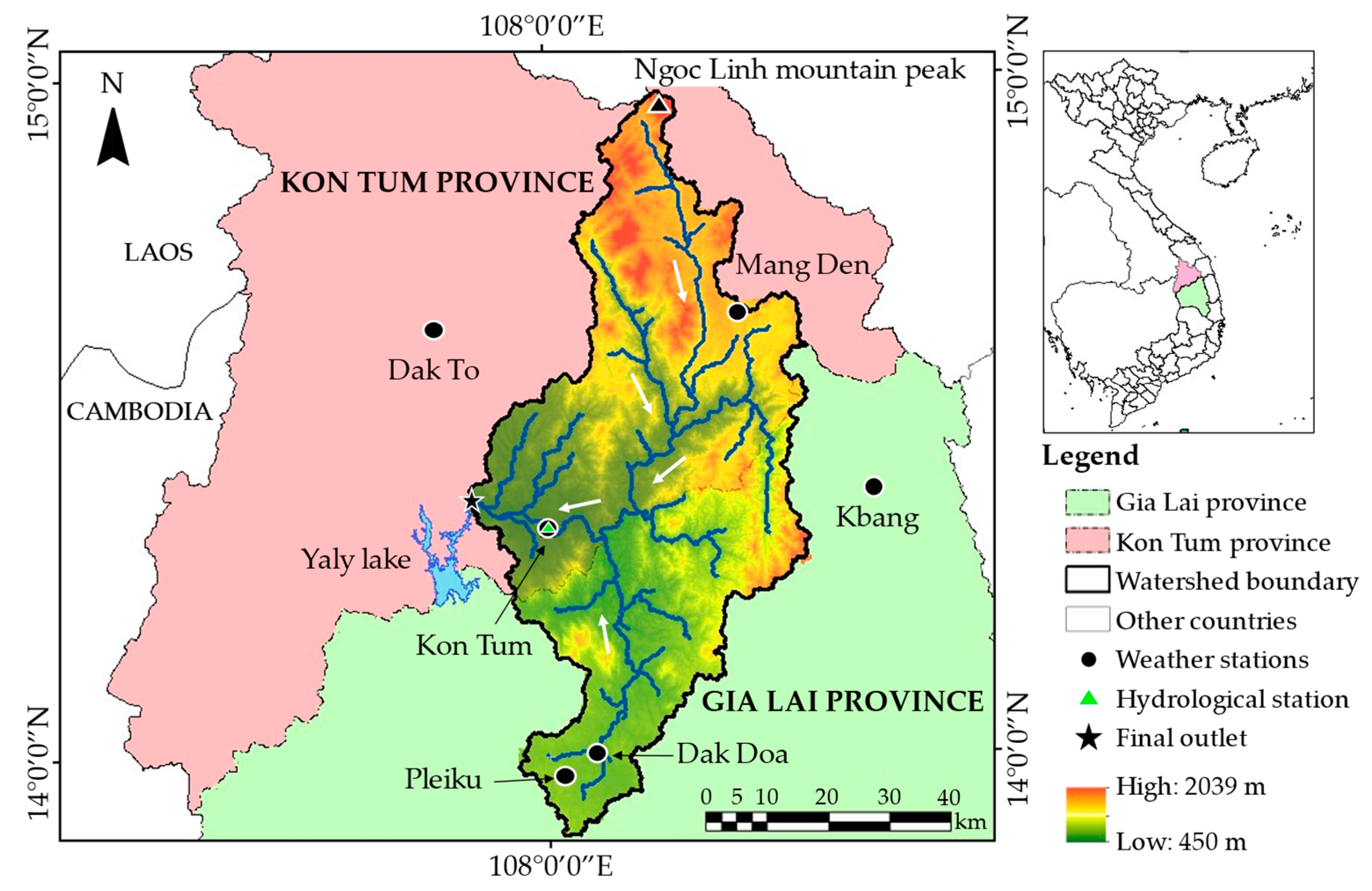
2.1. Study Area
2.2. Input Data
2.3. Methods
2.3.1. Brief Description of SWAT
2.3.2. SWAT Application
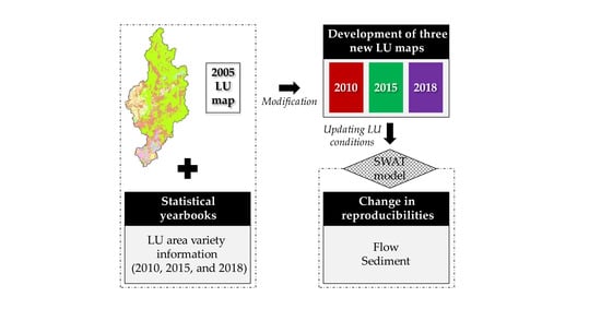
2.3.3. Land-Use Change Update Module
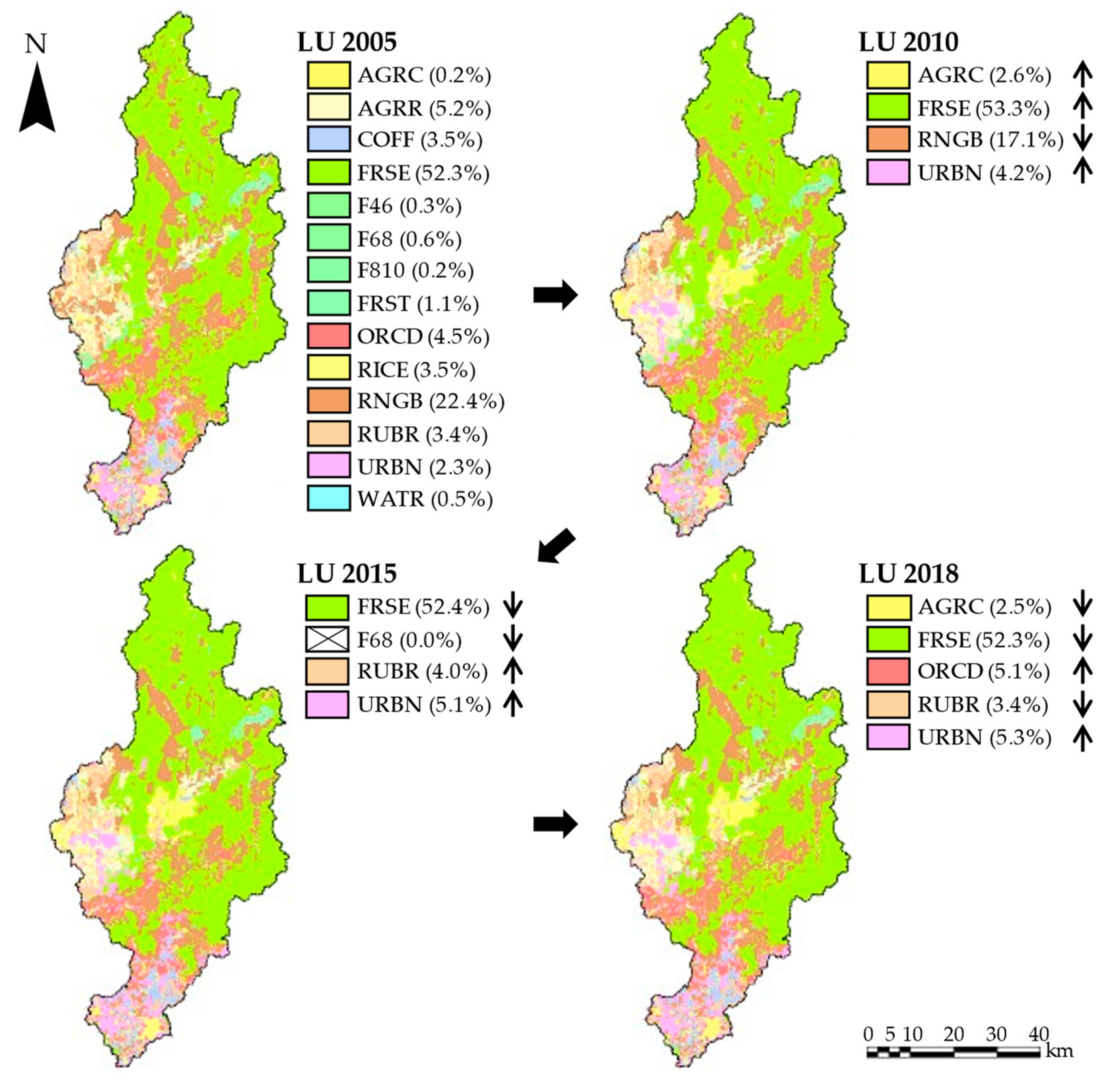
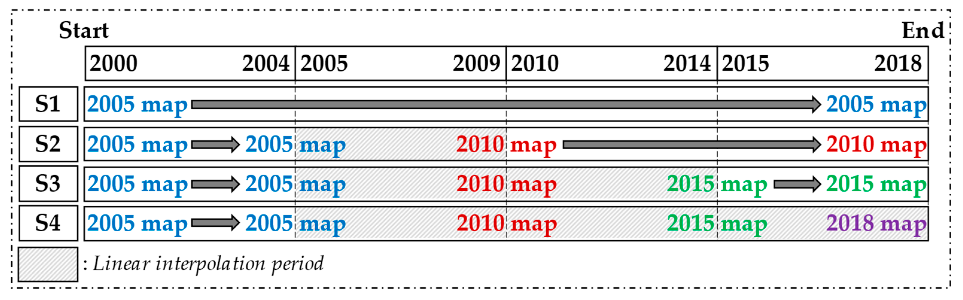
2.3.4. Preparation of Land-use Maps in 2010, 2015 and 2018 and Land-use Scenario Settings
2.3.5. Model Performance Evaluation
2.3.6. Uncertainty Analysis Method
3. Results
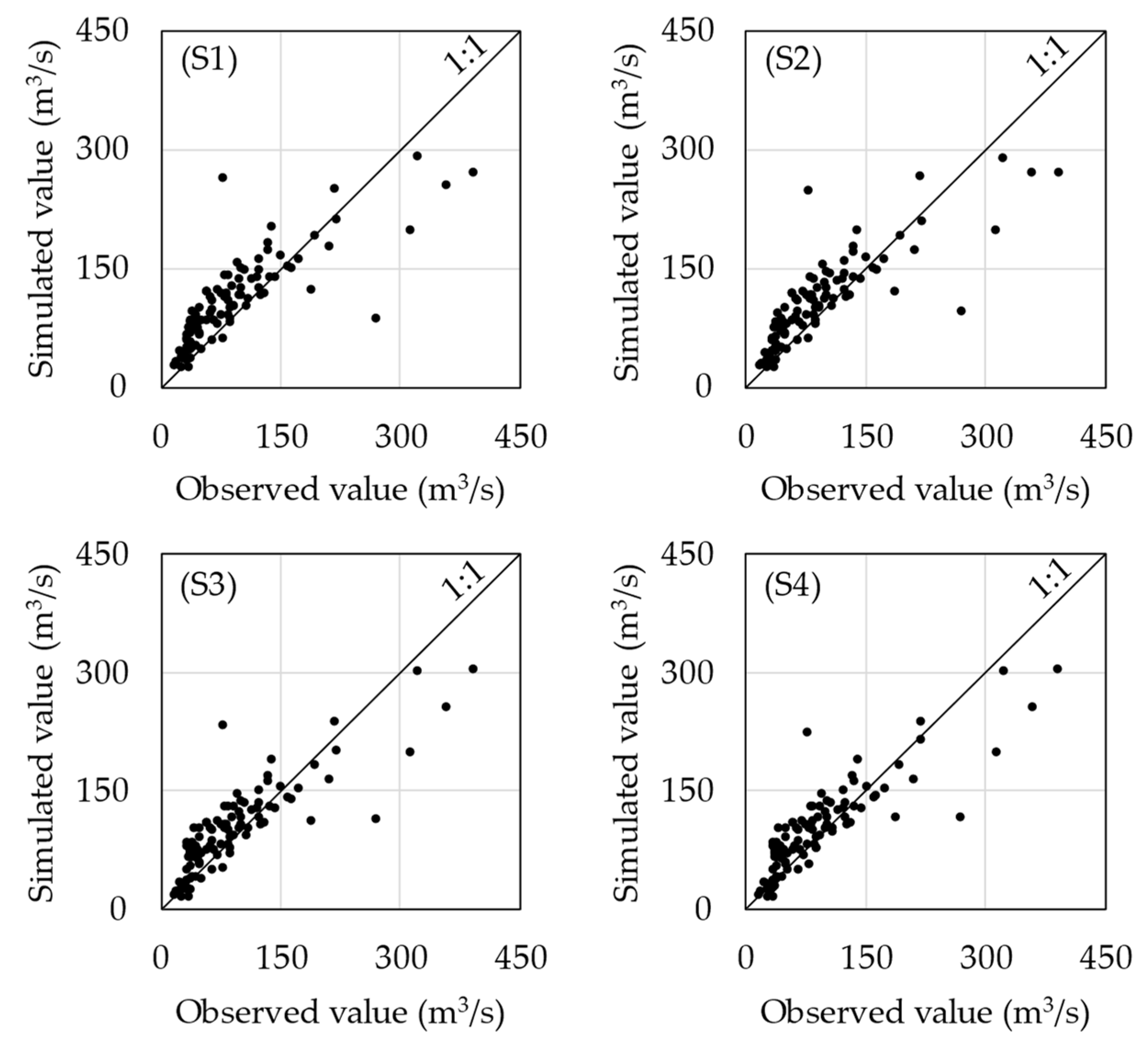
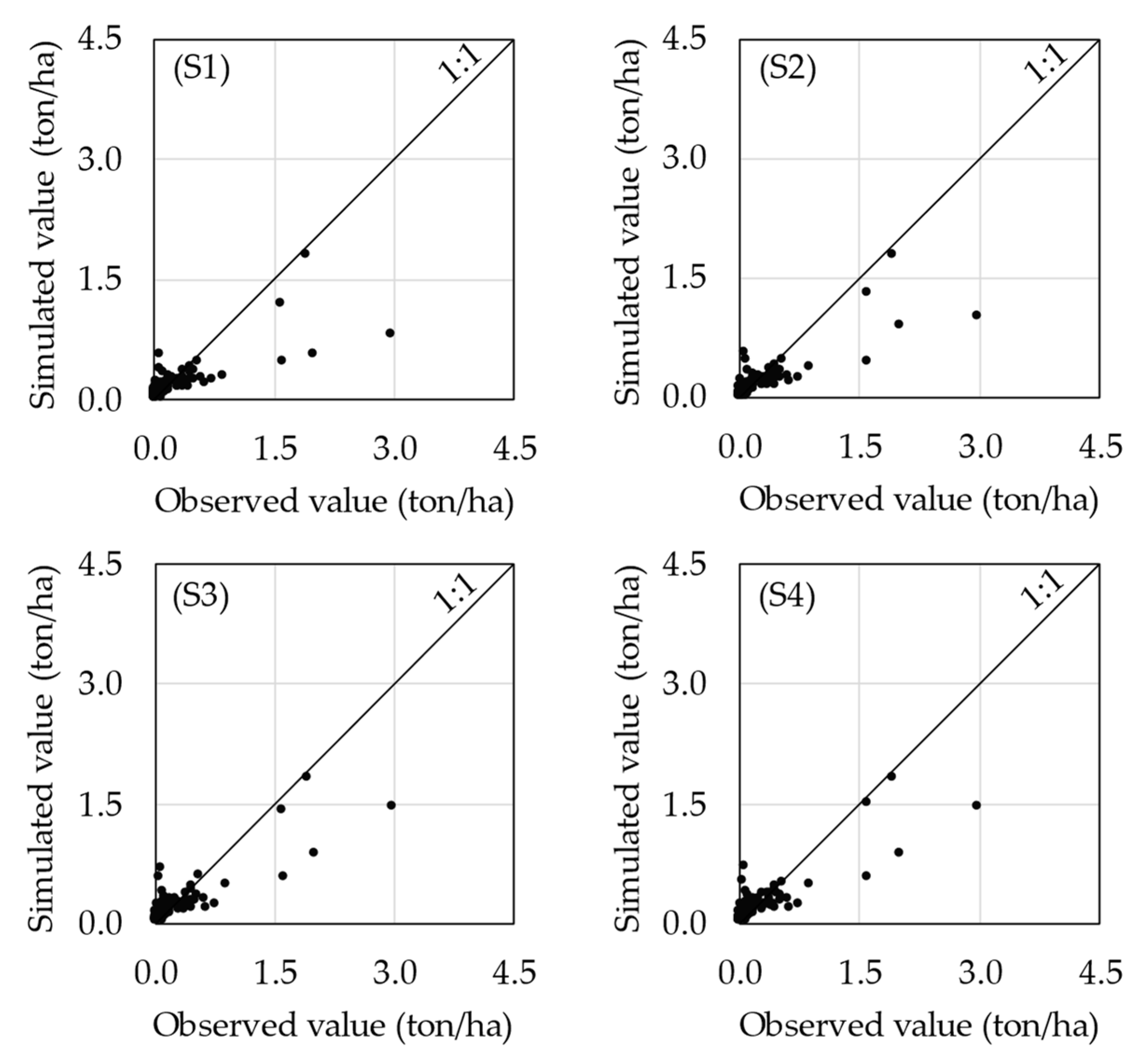
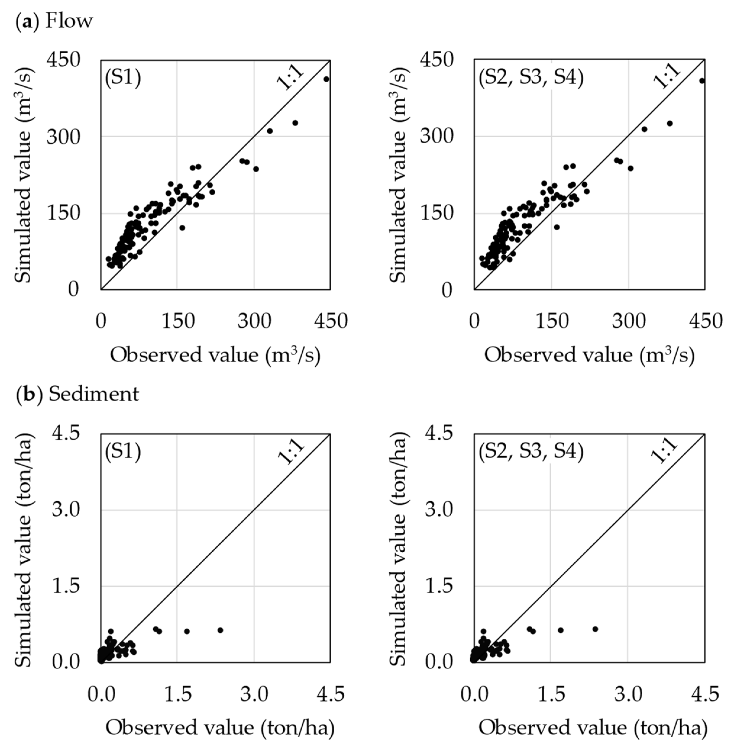
3.1. Reproducibility of Flow and Sediment in the Calibration Period (2000–2009)
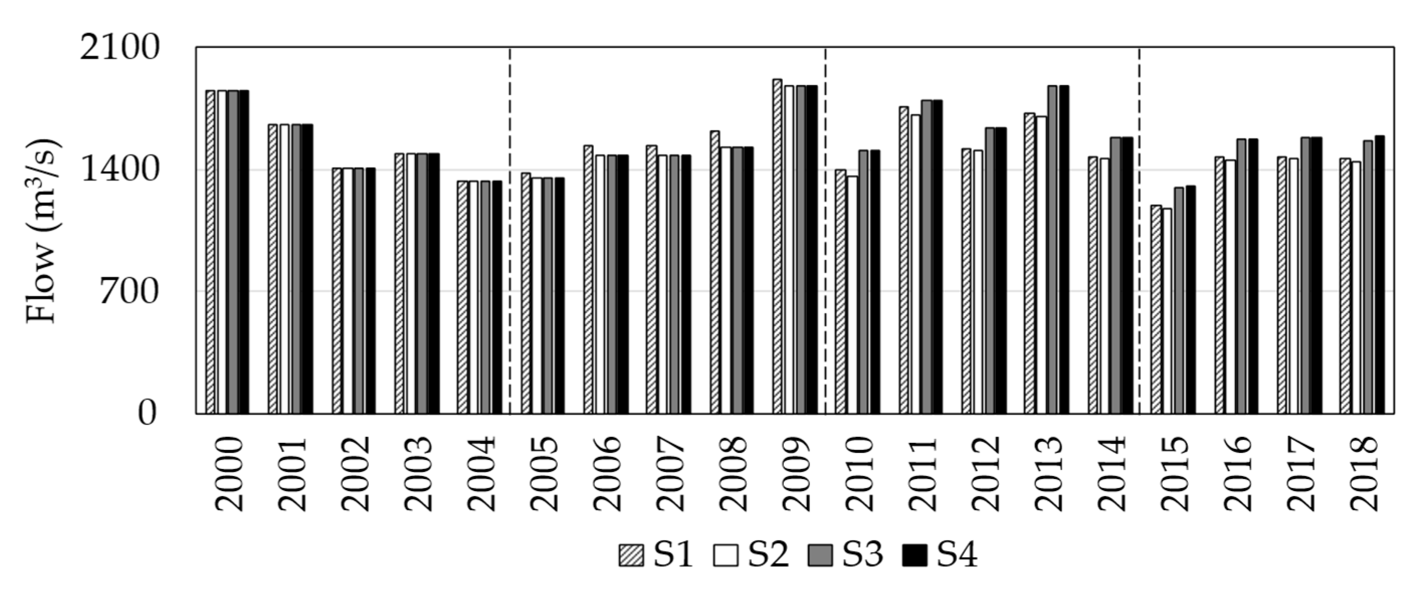
3.2. The Influence of Land-Use Update on Flow in the Validation Period (2010–2018)
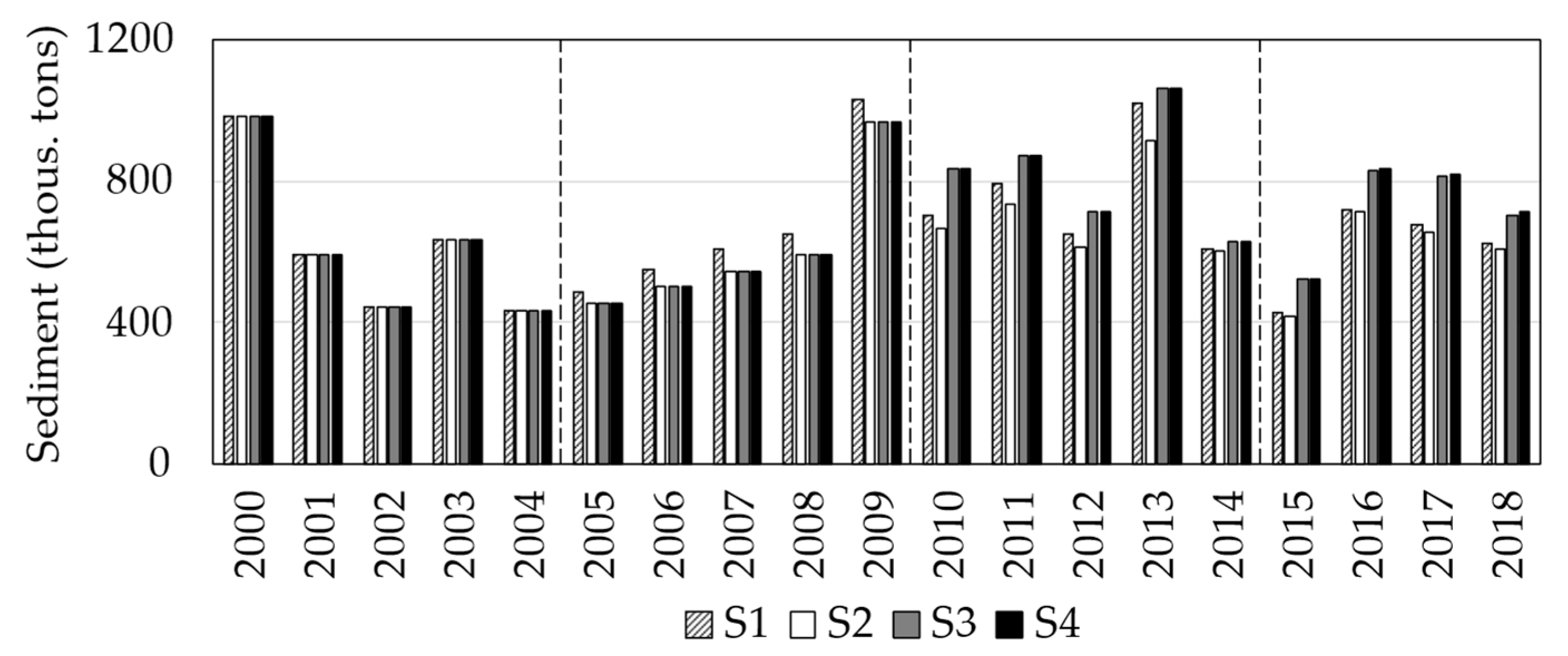
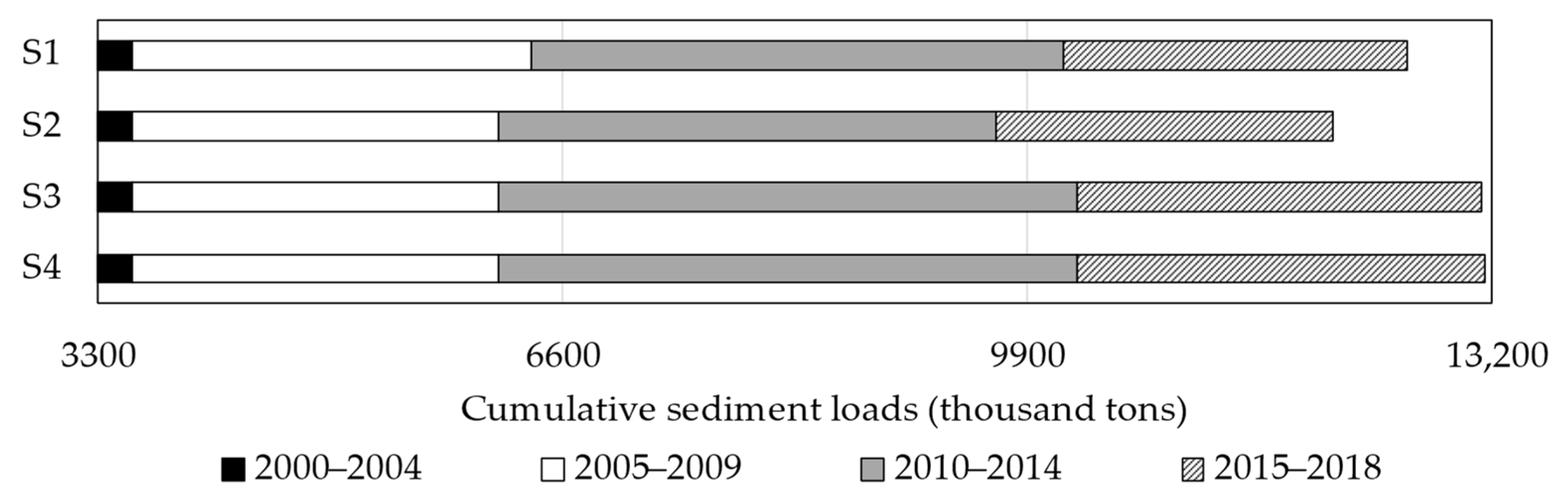
3.3. The Influence of Land-Use Update on Sediment in the Validation Period (2010–2018)
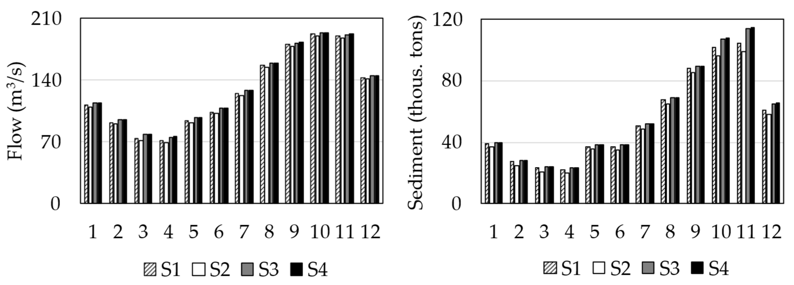
3.4. The Responses of Flow and Sediment to the Different Land-Use Input Conditions
4. Discussion
4.1. Importance of Land-Use Update For improving Modeling Performance
4.2. Influence of Land-Use Update for Flow and Sediment Simulation
4.3. Land-Use Policies in the Region for the Future, Including the Dakbla Watershed, and the Contribution from the Model Simulation
5. Limitation of the Study
6. Conclusions
- Three land-use maps were hypothetically established based on the local policy changes for land uses and the local statistic yearbook, and their effectiveness in improving the accuracy of the SWAT model outputs was confirmed.
- The impact of land-use changes on flow and sediment was expressed by the multiyear updated land-use input conditions more accurately than by the single static land-use condition at the watershed scale.
- The reproducibility of sediment simulation was more sensitive than the flow simulation.
- The updated land-use effects were higher for the rainy season than the dry season.
- S4 showed the best performance for reproducing the flow and sediment discharge trends.
Author Contributions
Funding
Conflicts of Interest
References
- Tingting, L.V.; Xiaoyu, S.; Dandan, Z.; Zhenshan, X.; Jianming, G. Assessment of soil erosion risk in Northern Thailand. Int. Arch. Photogramm. Remote Sens. Spat. Inf. Sci. XXXVII 2008, 8, 703–708. [Google Scholar]
- Nontananandh, S.; Changnoi, B. Internet GIS, based on USLE modeling, for assessment of soil erosion in Songkhram watershed, Northeastern of Thailand. Kasetsart J. Nat. Sci. 2012, 46, 272–282. [Google Scholar]
- Aflizar; Saidi, A.; Husnain; Indra, R.; Darmawan; Harmailis; Somura, H.; Wakatsuki, T.; Masunaga, T. Soil erosion characterization in an agricultural watershed in West Sumatra, Indonesia. Tropics 2010, 19, 29–42. [Google Scholar] [CrossRef] [Green Version]
- Li, M.; Shi, X.; Shen, Z.; Yang, E.; Bao, H.; Ni, Y. Effect of hillslope aspect on landform characteristics and erosion rates. Environ. Monit. Assess. 2019, 191, 598. [Google Scholar] [CrossRef]
- Somura, H.; Kunii, H.; Yone, Y.; Takeda, I.; Sato, H. Importance of considering nutrient loadings from small watersheds to a lake–A case study of the Lake Shinji watershed, Shimane Prefecture, Japan. Int. J. Agric. Biol. Eng. 2018, 11, 124–130. [Google Scholar] [CrossRef] [Green Version]
- Li, Z.; Liu, W.Z.; Zhang, X.C.; Zheng, F.L. Impacts of land use change and climate variability on hydrology in an agricultural catchment on the Loess Plateau of China. J. Hydrol. 2009, 377, 35–42. [Google Scholar] [CrossRef]
- Zettam, A.; Taleb, A.; Sauvage, S.; Boithias, L.; Belaidi, N.; Sánchez-Pérez, J.M. Modelling hydrology and sediment transport in a semi-arid and anthropized catchment using the SWAT model: The case of the Tafna river (Northwest Algeria). Water 2017, 9, 216. [Google Scholar] [CrossRef] [Green Version]
- Hallouz, F.; Meddi, M.; Mahé, G.; Alirahmani, S.; Keddar, A. Modeling of discharge and sediment transport through the SWAT model in the basin of Harraza (Northwest of Algeria). Water Sci. 2018, 32, 79–88. [Google Scholar] [CrossRef] [Green Version]
- Yuan, L.; Forshay, K.J. Using SWAT to evaluate streamflow and lake sediment loading in the Xinjiang river basin with limited data. Water 2019, 12, 39. [Google Scholar] [CrossRef] [PubMed] [Green Version]
- Son, N.T.; Binh, N.D.; Shrestha, R.P. Effect of land use change on runoff and sediment yield in Da river basin of Hoa Binh province, Northwest Vietnam. J. Mount. Sci. 2015, 12, 1051–1064. [Google Scholar]
- Munoth, P.; Goyal, R. Impacts of land use land cover change on runoff and sediment yield of Upper Tapi River Sub-Basin, India. Int. J. River Basin Manag. 2019, 18, 177–189. [Google Scholar] [CrossRef]
- Makhtoumi, Y.; Li, S.; Ibeanusi, V.; Chen, G. Evaluating water balance variables under land use and climate projections in the upper Choctawhatchee river watershed, in Southeast US. Water 2020, 12, 2205. [Google Scholar] [CrossRef]
- Li, Y.; Chang, J.; Luo, L.; Wang, Y.; Guo, A.; Ma, F.; Fan, J. Spatiotemporal impacts of land use land cover changes on hydrology from the mechanism perspective using SWAT model with time-varying parameters. Hydrol. Res. 2019, 50, 244–261. [Google Scholar] [CrossRef]
- Marhaento, H.; Booij, M.J.; Rientjes, T.H.M.; Hoekstra, A.Y. Sensitivity of streamflow characteristics to different spatial land-use configurations in tropical catchment. J. Water Resour. Plan. Manag. 2019, 145, 04019054. [Google Scholar] [CrossRef]
- Bieger, K.; Hörmann, G.; Fohrer, N. Detailed spatial analysis of SWAT-simulated surface runoff and sediment yield in a mountainous watershed in China. Hydrol. Sci. J. 2015, 60, 1–17. [Google Scholar] [CrossRef]
- Pai, N.; Saraswat, D. SWAT2009_LUC: A tool to activate the land use change module in SWAT 2009. Trans. ASABE 2011, 54, 1649–1658. [Google Scholar] [CrossRef]
- Tam, N.V. A Simple Tool for Creating TxtInOut Files for Simulating Land Use Change with SWAT. 2012. Available online: https://github.com/tamnva/SWAT_LUC (accessed on 20 June 2020).
- Moriasi, D.N.; Pai, N.; Steiner, J.L.; Gowda, P.H.; Winchell, M.; Rathjens, H.; Starks, P.J.; Verser, J.A. SWAT-LUT: A desktop graphical user interface for updating land use in SWAT. JAWRA J. Am. Water Resour. Assoc. 2019, 55, 1102–1115. [Google Scholar] [CrossRef] [Green Version]
- Martinelli, M.; Machado, E.H. Static and dynamic maps, developed from an analytical or synthesis reasoning, in school geographic Atlas: The methodological feasibility. Rev. Bras. Cartogr. 2014, 66, 899–920. [Google Scholar]
- Wang, Q.; Liu, R.; Men, C.; Guo, L.; Miao, Y. Effects of dynamic land use inputs on improvement of SWAT model performance and uncertainty analysis of outputs. J. Hydrol. 2018, 563, 874–886. [Google Scholar] [CrossRef]
- Wagner, P.D.; Bhallamudi, S.M.; Narasimhan, B.; Kumar, S.; Fohrer, N.; Fiener, P. Comparing the effects of dynamic versus static representations of land use change in hydrologic impact assessments. Environ. Model. Softw. 2019, 122, 103987. [Google Scholar] [CrossRef]
- Zhang, H.; Li, H.; Chen, Z. Analysis of land use dynamic change and its impact on the water environment in Yunnan plateau lake area-A case study of the Dianchi Lake drainage area. Procedia Environ. Sci. 2011, 10, 2709–2717. [Google Scholar]
- Son, N.T.; Huong, H.L.; Phuong, T.T.; Loc, N.D. Application of SWAT model to assess land use and climate changes impacts on hydrology of Nam Rom river basin in Vietnam. Preprints 2020, 1–17. [Google Scholar]
- Aghsaei, H.; Dinan, N.M.; Moridi, A.; Asadolahi, Z.; Delavar, M.; Fohrer, N.; Wagner, P.D. Effects of dynamic land use/land cover change on water resources and sediment yield in the Anzali wetland catchment, Gilan, Iran. Sci. Total Environ. 2020, 712, 136449. [Google Scholar] [CrossRef]
- Cuong, L.V. Irrigation Planning Kon Tum During a Period from 2011 to 2020 and Orientation to 2025; Central Vietnam Institute for Water Resources: Hanoi City, Vietnam, 2012; 200p. [Google Scholar]
- Prime Minister. The Rubber Development Planning up to 2015 and Vision to 2020; Prime Minister: Hanoi City, Vietnam, 2009; 6p. [Google Scholar]
- NASA and Japan ASTER Program. ASTER Global Digital Elevation Model (GDEM). Available online: https://asterweb.jpl.nasa.gov/gdem.asp (accessed on 10 June 2020).
- Bao, N.T.; Pryor, T.L. The relationship between global solar radiation and sunshine duration in Vietnam. Renew. Energ. 1997, 11, 47–60. [Google Scholar]
- Arnold, J.G.; Srinivasan, R.; Muttiah, R.S.; Williams, J.R. Large area hydrologic modeling and assessment. Part I: Model devel-opment. J. Am. Water Resour. Assoc. 1998, 34, 73–89. [Google Scholar] [CrossRef]
- Rostamian, R.; Jaleh, A.; Afyuni, M.; Mousavi, S.F.; Heidarpour, M.; Jalalian, A.; Abbaspour, K.C. Application of a SWAT model for estimating runoff and sediment in two mountainous basins in central Iran. Hydrol. Sci. J. 2008, 53, 977–988. [Google Scholar] [CrossRef]
- Somura, H.; Arnold, J.; Hoffman, D.; Takeda, I.; Mori, Y.; Di Luzio, M. Impact of climate change on the Hii River basin and salinity in Lake Shinji: A case study using the SWAT model and a regression curve. Hydrol. Process. 2009, 23, 1887–1900. [Google Scholar] [CrossRef]
- Tram, V.N.Q.; Liem, N.D.; Loi, N.K. Simulating surface flow and baseflow in Poko catchment, Kon Tum province, Vietnam. J. Water Clim. Chang. 2018, 10, 494–503. [Google Scholar] [CrossRef]
- Hussain, F.; Nabi, G.; Wu, R.S.; Hussain, B.; Abbas, T. Parameter evaluation for soil erosion estimation on small watersheds using SWAT model. Int. J. Agric. Biol. Eng. 2019, 12, 96–108. [Google Scholar] [CrossRef] [Green Version]
- Tibebe, D.; Bewket, W. Surface runoff and soil erosion estimation using the SWAT model in the Keleta Watershed, Ethiopia. Land Degrad. Dev. 2011, 22, 551–564. [Google Scholar] [CrossRef]
- Mosbahi, M.; Benabdallah, S.; Boussema, M.R. Assessment of soil erosion risk using SWAT model. Arab. J. Geosci. 2013, 6, 4011–4019. [Google Scholar] [CrossRef]
- Williams, J.R. Sediment routing for agricultural watersheds. JAWRA J. Am. Water Resour. Assoc. 1975, 11, 965–974. [Google Scholar] [CrossRef]
- Abbaspour, K.C.; Yang, J.; Maximov, I.; Siber, R.; Bogner, K.; Mieleitner, J.; Zobrist, J.; Srinivasan, R. Modelling hydrology and water quality in the prealpine/alpine Thur watershed using SWAT. J. Hydrol. 2007, 333, 413–430. [Google Scholar] [CrossRef]
- R Core Team. R: A Language and Environment for Statistical Computing; R Foundation for Statistical Computing: Vienna, Austria, 2016. [Google Scholar]
- Ministry of Agriculture and Rural Development. The Criteria for the Identification and Classification of Forests; Ministry of Agriculture and Rural Development: Hanoi City, Vietnam, 2009; 5p. [Google Scholar]
- Gia Lai Provincial People’s Council. Rubber Trees Development Under the Rubber Development Project in Gia Lai Province from 2008 to Present; Gia Lai Provincial People’s Council: Gia Lai Province, Vietnam, 2015. [Google Scholar]
- Kon Tum Provincial People’s Committee. The Status of Forest in Kon Tum Province; Kon Tum Provincial People’s Committee: Kon Tum Province, Vietnam, 2016; 5p. [Google Scholar]
- Ministry of Agriculture and Rural Development. Crop Conversion for the Inefficient Rubber Areas; Ministry of Agriculture and Rural Development: Hanoi City, Vietnam, 2018. [Google Scholar]
- Moriasi, D.N.; Gitau, M.W.; Pai, N.; Daggupati, P. Hydrologic and water quality models: Performance measures and evaluation criteria. Am. Soc. Agric. Biol. Eng. 2015, 58, 1763–1785. [Google Scholar]
- Santhi, C.; Arnold, J.G.; Williams, J.R.; Dugas, W.A.; Srinivasan, R.; Hauck, L.M. Validation of the SWAT model on a large river basin with point and nonpoint sources. J. Am. Water Resour. Assoc. 2001, 37, 1169–1188. [Google Scholar] [CrossRef]
- Nash, J.; Sutcliffe, J.V. River flow forecasting through conceptual models. Part I-A discussion of principles. J. Hydrol. 1970, 10, 282–290. [Google Scholar] [CrossRef]
- Saleh, A.; Arnold, J.G.; Gassman, P.W.; Hauck, L.M.; Rosenthal, W.D.; Williams, J.R.; McFarland, A.M.S. Application of SWAT for the Upper North Bosque river watershed. Trans. ASAE 2000, 43, 1077–1087. [Google Scholar] [CrossRef]
- Gupta, H.V.; Sorooshian, S.; Yapo, P.O. Status of automatic calibration for hydrologic models: Comparison with multilevel expert calibration. J. Hydrol. Eng. 1999, 4, 135–143. [Google Scholar] [CrossRef]
- Awotwi, A.; Anornu, G.K.; Quaye-Ballard, J.A.; Annor, T.; Forkuo, E.K.; Harris, E.; Agyekum, J.; Terlabie, J.L. Water balance re-sponses to land-use/land-cover changes in the Pra River Basin of Ghana. Catena 2019, 182, 1986–2025. [Google Scholar] [CrossRef]
- Stéphenne, N.; Lambin, E. A dynamic simulation model of land-use changes in Sudano-sahelian countries of Africa (SALU). Agric. Ecosyst. Environ. 2001, 85, 145–161. [Google Scholar] [CrossRef]
- Tripathi, M.; Panda, R.; Raghuwanshi, N. Identification and prioritisation of critical sub-watersheds for soil conservation management using the SWAT model. Biosyst. Eng. 2003, 85, 365–379. [Google Scholar] [CrossRef]
- Anand, J.; Gosain, A.; Khosa, R. Prediction of land use changes based on Land Change Modeler and attribution of changes in the water balance of Ganga basin to land use change using the SWAT model. Sci. Total Environ. 2018, 644, 503–519. [Google Scholar] [CrossRef]
- Dunning, C.M.; Black, E.; Allan, R.P. Later wet seasons with more intense rainfall over Africa under future climate change. J. Clim. 2018, 31, 9719–9738. [Google Scholar] [CrossRef] [Green Version]
- Seth, A.; Rauscher, S.A.; Biasutti, M.; Giannini, A.; Camargo, S.J.; Rojas, M. CMIP5 projected changes in the annual cycle of pre-cipitation in monsoon regions. J. Clim. 2013, 26, 7328–7351. [Google Scholar] [CrossRef]
- Yustika, R.D.; Somura, H.; Yuwono, S.B.; Arifin, B.; Ismono, H.; Masunaga, T. Assessment of soil erosion in social forest-dominated watersheds in Lampung, Indonesia. Environ. Monit. Assess. 2019, 191, 726. [Google Scholar] [CrossRef] [PubMed]
- Somura, H.; Takeda, I.; Arnold, J.; Mori, Y.; Jeong, J.; Kannan, N.; Hoffman, D. Impact of suspended sediment and nutrient loading from land uses against water quality in the Hii River basin, Japan. J. Hydrol. 2012, 450, 25–35. [Google Scholar] [CrossRef]
- National Assembly of Vietnam. Land Law; National Assesmbly of Vietnam: Hanoi City, Vietnam, 2013; 124p. [Google Scholar]
- Prime Minister. Project for Forest Protection, Restoration and Sustainable Development in the Central Highlands from 2016 to 2030; Prime Minister: Hanoi City, Vietnam, 2018; 6p. [Google Scholar]
- Ministry of Agriculture and Rural Development. The Sustainable Forestry Development Strategies for the Period 2021–2030, and a Vision to 2050; Ministry of Agriculture and Rural Development: Hanoi City, Vietnam, 2019; 149p. [Google Scholar]
- Mengistu, A.G.; Van Rensburg, L.D.; Woyessa, Y.E. Techniques for calibration and validation of SWAT model in data scarce arid and semi-arid catchments in South Africa. J. Hydrol. Reg. Stud. 2019, 25, 1–18. [Google Scholar] [CrossRef]
- Cho, J.; Bosch, D.; Lowrance, R.; Strickland, T.; Vellidis, G. Effect of spatial distribution of rainfall on temporal and spatial uncertainty of SWAT output. Trans. ASABE 2009, 52, 1545–1556. [Google Scholar] [CrossRef]
- Khoi, D.N.; Suetsugi, T. The responses of hydrological processes and sediment yield to land-use and climate change in the Be river catchment, Vietnam. Hydrol. Process. 2014, 28, 640–652. [Google Scholar] [CrossRef]
- Phomcha, P.; Wirojanagud, P.; Vangpaisal, T.; Thaveevouthti, T. Predicting sediment discharge in an agricultural watershed: A case study of the Lam Sonthi watershed, Thailand. ScienceAsia 2011, 37, 43–50. [Google Scholar] [CrossRef]
- Chandra, P.; Patel, P.; Porey, P.; Gupta, I. Estimation of sediment yield using SWAT model for Upper Tapi basin. ISH J. Hydraul. Eng. 2014, 20, 291–300. [Google Scholar] [CrossRef]
- Oeurng, C.; Sauvage, S.; Sánchez-Pérez, J.M. Assessment of hydrology, sediment and particulate organic carbon yield in a large agricultural catchment using the SWAT model. J. Hydrol. 2011, 401, 145–153. [Google Scholar] [CrossRef] [Green Version]


| Items | Flow (m3/s) | TSS (mg/L) |
|---|---|---|
| Min/Max | 6.8/3500 | 1.0/1699.3 |
| Median | 66.3 | 34.1 |
| Mean ± SD | 94.7 ± 106.0 | 80.9 ± 93.0 |
| Monthly Flow | Monthly Sediment | |||||
|---|---|---|---|---|---|---|
| R2 | NSI | PBIAS | R2 | NSI | PBIAS | |
| (%) | (%) | |||||
| Static LU Condition | ||||||
| Calibration (2000–2009) | 0.78 | 0.70 | −8.1 | 0.74 | 0.66 | 31.5 |
| Validation (2010–2018) | 0.68 | 0.62 | −14.6 | 0.63 | 0.54 | 18.4 |
| Updated LU Conditions | ||||||
| Calibration (2000–2009) | ||||||
| S2, S3, S4 | 0.78 | 0.71 | −11.2 | 0.75 | 0.67 | 29.2 |
| Validation (2010–2018) | ||||||
| S2 | 0.68 | 0.64 | −16.3 | 0.63 | 0.55 | 18.6 |
| S3 | 0.70 | 0.65 | −8.0 | 0.67 | 0.62 | 2.1 |
| S4 | 0.70 | 0.65 | −7.4 | 0.67 | 0.62 | 1.1 |
| Target Components | RD (S2 vs. S1) | RD (S3 vs. S1) | RD (S4 vs. S1) |
|---|---|---|---|
| Surface runoff | −2.5% | 5.1% | 5.2% |
| Groundwater | 0.8% | −1.4% | −1.5% |
| Water yields | −1.7% | −1.0% | −1.0% |
| Evapotranspiration | −5.3% | 1.6% | 1.8% |
| Sediment yields | −24.3% | 25.7% | 27.1% |
Publisher’s Note: MDPI stays neutral with regard to jurisdictional claims in published maps and institutional affiliations. |
© 2021 by the authors. Licensee MDPI, Basel, Switzerland. This article is an open access article distributed under the terms and conditions of the Creative Commons Attribution (CC BY) license (http://creativecommons.org/licenses/by/4.0/).
Share and Cite
Tram, V.N.Q.; Somura, H.; Moroizumi, T. The Impacts of Land-Use Input Conditions on Flow and Sediment Discharge in the Dakbla Watershed, Central Highlands of Vietnam. Water 2021, 13, 627. https://doi.org/10.3390/w13050627
Tram VNQ, Somura H, Moroizumi T. The Impacts of Land-Use Input Conditions on Flow and Sediment Discharge in the Dakbla Watershed, Central Highlands of Vietnam. Water. 2021; 13(5):627. https://doi.org/10.3390/w13050627
Chicago/Turabian StyleTram, Vo Ngoc Quynh, Hiroaki Somura, and Toshitsugu Moroizumi. 2021. "The Impacts of Land-Use Input Conditions on Flow and Sediment Discharge in the Dakbla Watershed, Central Highlands of Vietnam" Water 13, no. 5: 627. https://doi.org/10.3390/w13050627