
The Terraces of the Anti-Atlas: From Abandonment to the Risk of Degradation of a Landscape Heritage

National School of Forest Engineering, BP 511, Avenue Moulay Youssef, Tabriquet, Salé 11 015, Morocco
Water 2021, 13(4), 510; https://doi.org/10.3390/w13040510
Submission received: 15 October 2020
/
Revised: 7 February 2021
/
Accepted: 8 February 2021
/
Published: 16 February 2021
(This article belongs to the Special Issue Terraced Landscapes and Hydrological-Geological Hazards)
Abstract
:The Anti-Atlas is subject to an intense rural exodus. The agricultural terraces built for several centuries have been abandoned. They are gradually deteriorating. The risks of runoff and erosion are becoming significant. The objective was to study the effect of the abandonment of terraces on the risks of runoff and erosion in the territory of two villages, Tizerkine and Timzemzit. After the characterization of the soil surface conditions, the extent of erosion and the risk of runoff were qualified according to the age of abandonment. Erosion was assessed by estimating the “soil surface factor” (PAP/CAR method) and infiltration by the double ring method. The abandonment of the terraces has led to a reduction in the plant cover of the soil surface and its opening and to enhancing its compaction. The risk of runoff is high. A year of abandonment reduced the infiltration from 301.8 mm/h (SD: 105.8 mm/h) to 129.6 mm/h (SD: 28.9 mm/h). Furthermore, 5 years of abandonment reduced it to 62.9 mm/h (SD: 14.9 mm/h). The walls of the terraces are gradually being destroyed with an increasing age of abandonment. More than half (57%) of the terraced slope surface has suffered moderate to high water erosion. More than 11% of the surfaces are severely degraded after 20 years of abandonment. The heritage made up of these managed slopes is being lost. Particular attention must be paid to these landscapes in order to better rehabilitate and develop them.
1. Introduction
The Anti-Atlas is characterized by its arid slopes managed in terraces by ancestral populations. Valleys to the summit, on slopes of 40 to 60%, extend from stepped terraces supported by walls [1]. However, the soil losses for this mountain range are high [2,3]. Degraded argan forest is observed over large areas, which accentuates the process of desertification [4,5]. The climatic hazards characteristic of this arid region and the economic contrast between the urban and rural areas have gradually led to a massive rural exodus of young “Amazigh” populations to the country’s large cities (Casablanca, Marrakech and Laâyoune) and to Europe (France, Belgium, Germany and Holland) [6,7].
Thus, the vast slopes managed in terraces are neglected. As a result of their abandonment, the terraces are gradually deteriorating, and their role in soil and water conservation is less and less assured. The abandoned plots, whose wall has collapsed, present a systematic compaction of anthropogenic and climatic origin of the superficial soil horizons [8]. This compaction is leading to a decrease in the infiltration process and, therefore, an increase in runoff [9]. These arable plots are thus threatened in the short term by the amplification of erosion phenomena. For the populations upstream, the consequences are a reduction in cultivated areas, decrease in agricultural productivity and increase in the violence of floods, compromising sustainable agricultural development projects. In a downstream logic, this state of affairs is causing the premature silting up of the dams necessary for the irrigation of intensive crops in the plains of Souss-Massa [1].
This region, yet at the heart of Morocco’s endemic argan forest, has not seen many studies to understand the effect of the abandonment of the terraces on the hydrological functioning of the soils, slopes and basins. This study focused on the territory of two villages, “Tizerkine” and “Timzemzit”, representative of the Western Anti-Atlas, 7 km south of the “Souk El Arba des Aït Baha” center. The main objective related to the study of the effects of the abandonment of the terraces on the surface conditions, the hydrological behavior of the soils and the development of erosion forms. The surface conditions and hydrological behavior of the soils on the terraces still plowed and the abandoned terraces (for 1 year, 2 years, 5 years and 20 years) were compared.
2. Materials and Methods
2.1. Presentation of the Study Area
The villages of “Tizerkine” and “Timzemzit”, forming the same human unit, culminate at altitudes of 735 and 715 m, respectively (Figure 1). The territory extends over rugged terrain with slopes of around 40 to 60%. The geologic bedrock is a complex with two distinct sets of characteristics: weathered, friable and erosion-sensitive eruptive rocks and a minority hard substrate of quartzite and basalt.
The pedological complex belongs to that of the slopes of Jbel Lkist. The dominant soils are poorly developed modal soils. The textures are silty–sandy, and the soils are sensitive to the beat of raindrops (crust formation). The soils become encrusted after the first rainy events, often stormy, in late fall–early winter. The annual rainfall at the Aït Baha station is 211 mm, with a coefficient of variation of 54% over 39 years (1980–2018). The maximum daily rains at the Ait Baha station with return periods of 2, 10 and 100 years are, respectively, 42.6, 64.0 and 90.6 mm [10]. The mean annual temperature is 25 °C, with a minimum of 5 °C and a maximum of 36.8 °C. The pluviometric regime is of the Winter–Autumn–Spring–Summer type, with a Martonne index of 6 mm/°C. The climate is thus arid and characterized by significant inter- and intra-annual variability [11].
The vegetation is steppe, xerophilic and thermophilic [4]. The argan (Argania spinosa)-grazed formations have an average density of 40 trees per hectare and are characterized by a virtual absence of a shrub and herbaceous layer. We note the presence of argan forest undergrowth with an association of cactoid euphorbia. Extensive crops are quite common and mainly consist of barley.
2.2. Mapping of the Degradation of Terraces
2.2.1. Preliminary Phase
From the observation of the signs of degradation of the stone wall and with the help of the population, the ages of the abandonment of the different sets of terraces were determined. Prospecting the land with the peasants showed us that the land was abandoned in waves, during the same period and globally on the same slopes. The abandonment age was roughly estimated and was used as an indication for the cessation of agricultural activities on the terraced plots. This approximation will undoubtedly have had an effect on the accuracy of the results and on the cause–effect relationship between land abandonment and soil behavior. Different, but approximately similar, places can be found in the same age group. We defined 5 abandonment age groups (Table 1).
2.2.2. Mapping of the Abandonment and Degradation of Terraces
Twenty transects (20) were distributed, from one end to the other, over the entire territory of the two villages, taking into account the heterogeneous landscape of the environment. With a group of volunteer peasants who know their territories, we proceeded to describe the terraces and determine their ages of abandonment along these transects and on the neighboring slopes.
A GPS was used to locate this information spatially. A comparison with the photointerpretation provided the data necessary to delimit the different sets of terraces of the same age of abandonment. The transfer of data on a topographic background to 1/50,000th by the GIS software made it possible to extrapolate the data necessary to characterize the abandonment phenomenon and to understand the extent of the deterioration of the terraces.
2.3. Characterization of Soil Surface Conditions
The surface states were characterized by the point-quadrat method. On each terrace, around the infiltration observation sites, three 1 m transects were randomly installed. Every 2 cm, the state of the surface was characterized: an open surface, OS (the presence of clods, galleries and free pebbles); a closed surface (crust and pebbles trapped in the soil matrix); a surface covered by vegetation, VC (vegetation, litter and loose stones); and a bare surface, BS. Each 1 m transect provided 100 observation points. The surface parameters are expressed in %. The compaction of the soil surface was observed by measuring the penetration resistance (PEN kg/cm²) using a pocket penetrometer at 10 points around each infiltration observation site. The PEN expresses the resistance of the soil to the penetration of a steel cylinder 5 mm in diameter and 5 mm in height. Around each site, three soil samples were taken with a cylinder 7.5 cm in diameter and 7.5 cm in height to measure the bulk density of the soil (db g/cm3) [12].
All of these parameters make it possible to characterize the surface conditions of the soils in terms of cover, closure and compaction, in relation to the age of the abandonment of the terraces. These parameters affect the infiltration capacity for water in the soil, the occurrence of runoff and, therefore, soil erosion.
2.4. Evaluation of the Effects of Abandoning Terraces on the Process of Water Infiltration into the Soil
The method of double concentric rings (internal diameter, 20 cm) was used to assess the infiltration capacity (if, mm/h) of surface soil horizons in the field [13]. The method consists of following the height of the water that seeps into the soil inside the internal cylinder for 45 min with a time step of 5 min (until stabilization). The value of the final (constant) infiltration is often reached by around 30–35 min. The outer cylinder serves to prevent lateral infiltration into the inner cylinder; the water is supposed to flow vertically.
The infiltration tests were carried out on a couple of terraces for each of the states: terraces still plowed, terraces abandoned for 1 year, terraces abandoned for 5 years, terraces abandoned for 10 years and terraces abandoned for at least 20 years. This made a total of 10 terraces. On each of the terraces, three repetitions of the infiltration test were carried out. The final infiltration for each test was calculated as the average of the last two measurements (at 40 and 45 min).
2.5. Assessment of the Impact of Degradation of Terraces on the Erosion Process
In the field, the qualitative assessment of erosion was conducted by estimating the “soil surface factor” (SSF). The SSF, ranging from 0 to 100, is an index that assesses the state of degradation of a slope (plot) by water erosion [14,15]. It consists of observing the plot and assigning values to the degrees of the factors linked to the erosion process, thus making it possible to classify the plots by the degree of erosion: soil movement, surface litter, stones on the soil surface, witnesses of erosion, flow model, ravines, and gullies.
For each age group of abandonment and degradation, two estimates of the “SSF” were made on two terraces. The calculation of the “SSF” was then performed by adding the values assigned to the various factors related to the erosion process. The associated erosion degrees are summarized in the Table 2.
3. Results and Discussion
3.1. The Abandonment of the Terraces in the Territory of the Villages of Tizerkine and Timzemzit
Throughout the territory of Tizerkine–Timzemzit (283.9 ha), only a quarter (24.9%) of the terraces remain maintained by the population and are still used for a fairly low and very irregular crop production (grains and straws of cereals, and argan fruit), and the rest have been abandoned (Figure 2, Table 3). Just over three percent (3.3%) were abandoned during the year 2017–2018. Almost 12% were so 10 years ago. More than half of the area occupied by abandoned terraces has been there for at least 20 years (56.2%). This is partly explained by the intense and recurrent droughts that Morocco has experienced since the 1980s and, in particular, in the Anti-Atlas. Indeed, the droughts in the region have been intense since the 1960s and continue to be so today. In Ait Baha, in 1961, the precipitation was 68 mm, which represents a very low level of average precipitation (28.4%) [10,16].
The mapping of the abandonment of terraces shows that the abandonment of agricultural land has been progressive in time and space. The reduction in agricultural activities in these villages in particular and in the Anti-Atlas in general began from the independence of the Kingdom, with the departure of the settlers, who encouraged the workers of the region to follow them to France. Faced with the agroecological hostility of the region, emigration increased during the 1960s and 1970s to Europe in the search for employment (France, Belgium, Holland and Germany) and to the big cities of the Kingdom for the search for business opportunities (Casablanca). The authors in [7] noted that during the last few decades (since the 1980s), the Souss-Massa plain, which has experienced significant socioeconomic development through the installation of intensive agriculture and the development of the tourism sector, has increased, even more, the emigration of young people from the mountains in search of job opportunities and business activities. The mountain has emptied in favor of the plain and the towns.
With the blatant reduction in the workforce in these villages (the departure of young boys), the terraces furthest from the villages were abandoned first. Gradually, over time, it became the case that only the terraces close to the houses are still used to produce a little grain and cereal straw for the domestic animals still kept in the pseudofarms. The rest of the families still there are only there to maintain ownership of the land. For major work, such as the maintenance of the walls of the terraces and the cleaning of the matfia (water cisterns), the households call on external labor from other arid regions of the Kingdom such as “Kalaâ des Sraghna” and “R’hamna”.
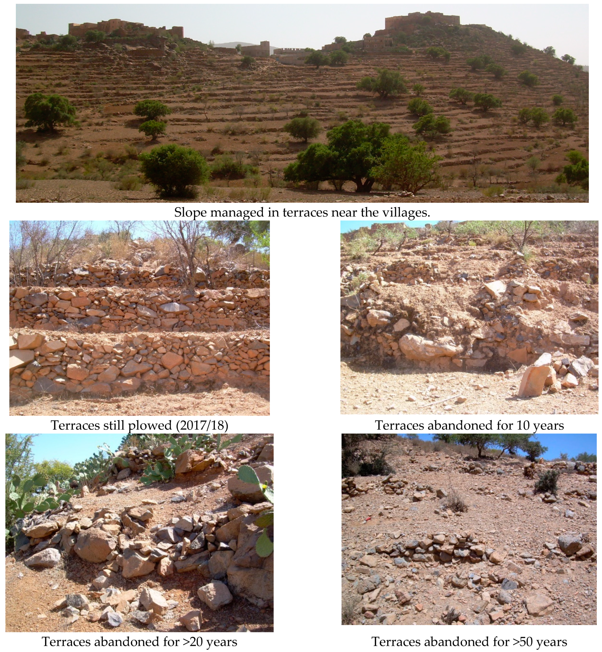
The abandonment of terraces is, therefore, not a recent phenomenon in this region. However, it is now that the negative consequences for the soil and the landscape are starting to appear and are becoming spectacular. Other authors have shown it in the Anti-Atlas as well [17]. The abandonment of terraces, mainly due to social driving forces (little exchange between generations and emigration) rather than natural or ecological (droughts or a lack of water resources), is leading to land degradation and the loss of an important cultural heritage (Figure 3).
3.2. Effects of the Abandonment of Terraces on the Conditions of Soil Surfaces
The results of the field observations (Table 4) show that the abandonment of terraces has contributed strongly and quickly from the first year to the reduction in the quality of the soil surface conditions. Indeed, the cessation of tillage activities (plowing with traditional plows), de-stoning and fertilization (the addition of manure) is leading, on the one hand, to a reduction in the opening of the surface and its cover, and the plants at ground level, and on the other hand, the compaction of the surface layer (7.5 cm) and the formation of a surface crust. This crust can reach thicknesses of 2 to 3 mm. Indeed, soils with silty or sandy loam textures are vulnerable to the beating of raindrops. The surface aggregates are inconsistent, and the surface easily loses its structure. A denser layer consisting of fine particles forms on the surface. It strongly impacts the ability of the soil to allow water infiltration [9,18].
The differences are significant between the terraces still cultivated and those abandoned in the first year of abandonment. Indeed, the abandonment of terraces for a year leads to a reduction of 28.4% in the opening of the surface of the ground and 34.5% in its plant cover (at ground level) and a compaction of 20%. After 10 years of abandonment, these effects become more pronounced. The opening and surface coverage are reduced by 83.6% and 63.5%, respectively. The compaction of the surface is even higher. The resistance to penetration and the bulk density of the surface increase by 60% and 18.2%, respectively. These results confirm those of [19,20,21], who showed that the abandonment of terraces contributes to the gradual loss of the agronomic quality of soils. The soils not or little worked regularly become “frozen” (compacted) in the eyes of the peasants. They store less water, and crop productivity drops.
According to these results, the abandonment of terraces reaches the maximum of its harmful effects on the quality of the soil surface from the fifth year. The differences are not significant between 5, 10 and 20 years of abandonment for the opening, the vegetation cover and the compaction of the surface.
3.3. Effect of Abandonment of Terraces on Soil Infiltration Capacities
Even if it is difficult to indicate a cause-and-effect relationship between the abandonment of terraced land and the hydrological behavior of the soils, the results (Table 5) allow us to affirm that when a terrace is abandoned, the final infiltration capacity of the surface layer of the soil drops by 57.06% in the first year (with an alpha risk of 5%) and 79.16% after five years. After the first five years of abandonment, it continues to decrease but not significantly. This shows that the reduction in the soil infiltration capacity of abandoned terraces is closely related to the effects on the quality of the soil surface. The reduction in plant cover and the openness of the surface as well as its compaction lead to a decrease in the capacity of water to infiltrate the soil. Several authors, including [22,23,24], showed that in arid zones, the infiltration capacity of a soil is governed by its surface condition. The reduction in plant cover, the closing of the soil surface (crust) and its compaction are the main factors in the drop in the rate of water infiltration into the soil. Working in the Rif in a semiarid climate and on marly substrates, [25,26] showed that the abandonment of land leads to an increase in the amount and frequency of runoff and, therefore, to the appearance of forms of ravine erosion on sloping slopes.
The results of the double ring infiltration test show that soil compaction is significant during the first five years of abandonment. The final infiltration capacity is reduced by more than half compared to that of a plowed plot. The volume occupied by the porosity of the soil is less and less important as the duration of the abandonment increases. After five years of abandonment, the soil compaction reaches a maximum and, therefore, no longer changes significantly.
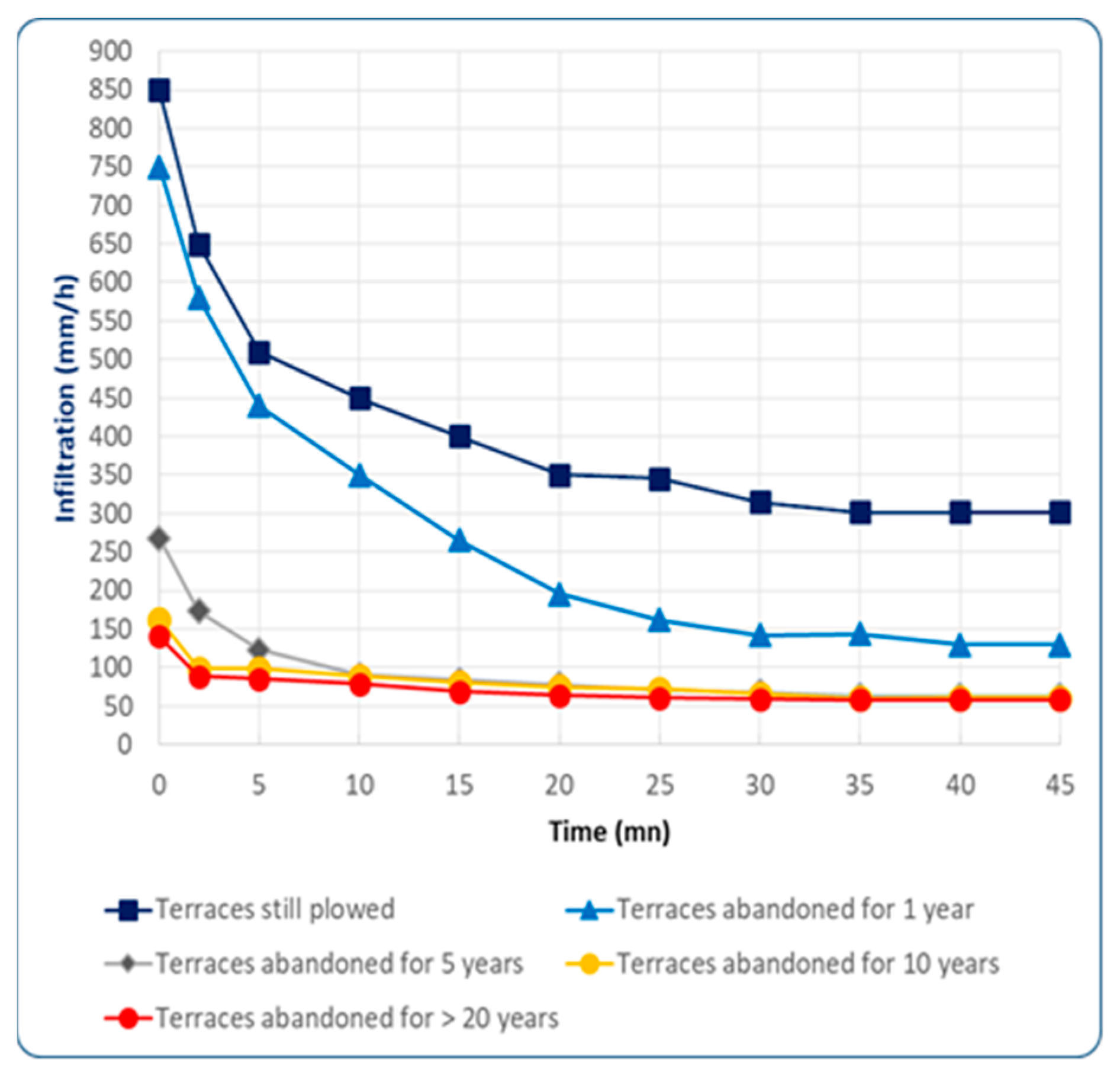
Figure 4 shows the change in the water infiltration capacity (if, mm/h) in the soil as a function of time for the different abandonment ages studied. It is notable that the abandonment of the terraces reduces, in addition to the final infiltration capacity, the volume of water infiltrated over time in a drastic manner. The rate of infiltration stabilizes from the 25th minute for 1 year of abandonment at a very low rate compared to that for terraces still plowed. For 5 years of abandonment, the threshold is reached from the 10th minute. Even more impacted for the ages of 10 and >20, it reaches the plateau at 5 min with a very low value of around 60 mm/h. These reductions are explained by changes in the surface conditions of the soils of abandoned terraces: surface closure (crust), compaction, less vegetation and litter. With the reduction in infiltration capacity, the abandoned terraces over large areas are believed to be responsible for the increasingly flashing, intense and frequent floods in the Anti-Atlas and the surrounding plains.
The closure of the soil surface condition and its compaction by the abandonment of the terraces impacting the reduction in the capacity for water infiltration into the soil on the sloping sides of the Anti-Atlas would undoubtedly result in an increase in runoff responsible for triggering water erosion. The degradation of the slopes, whose terraces have been abandoned, is inevitable.
Around the study area, the terraces have mostly been abandoned for over 20 years. At the watershed scale, infiltration is, thus, considerably reduced in favor of runoff. The hydrological behavior of those watersheds could be entirely modified and deserves being studied quantitatively.
This confirms that the maintenance of agricultural activities (plowing, manuring and crops) on the terraces and their maintenance improve their capacities to allow infiltration, to store rainwater and to produce less runoff. Taking this into account, the Moroccan Government, with the support of the UNDP, has developed a payment mechanism for ecosystem services (PES) based on the maintenance and planting (almond trees) of the terraces in the Western Anti-Atlas [27].
3.4. Erosive Process and Soil Degradation of Abandoned Terraces
The results of the qualitative method of PAP/CAR [13] show that the longer a terrace has been abandoned, the more active the erosion process. Thus, a plot with a wall in good condition will have a stable degree of erosion. The initial stage of the erosive process on plots with degraded walls is characterized by the appearance of white spots and a sparse and undeveloped distribution of rock fragments. The diffuse runoff appearing on the abandoned terraces washes the surface of the soil and carries away fine elements and organic matter. The stones appear and become numerous on the surface. Therefore, in just 5 years of a lack of maintenance, a plot may already have a degree of erosion, but low. After 20 years, the signs of erosion (the accumulation of stones, the abrasion of the surface layer of the soil, and rills) double in intensity, and we reach a moderate erosion stage. Linear erosion becomes active through rills, which can develop into gullies, due to the concentration of runoff. Finally, after 50 years of neglect, the soil surface factor, “SSF”, is multiplied by five, and the intensity of the erosive process reaches a critical stage characterized by the frequent presence of gullies. Some abandoned slopes are transformed into badlands (Figure 5).
The comparison of the results obtained with this method with the mapping of the ages of abandonment of the terraces (Figure 2) made it possible to affirm, at the scale of the territory studied, that:
- Of the managed slopes, 16% are exposed to a low degree of erosion;
- Of the managed slopes, 46% are exposed to a moderate degree of erosion;
- Of the managed slopes, 11% are exposed to a critical degree of erosion.
The abandonment of terraces increases the erosion process in the short term. With age, the runoff becomes more and more important, becomes more concentrated and acquires stronger erosion forces. Rills widen over time, especially in the middle and at the bottom of abandoned slopes. The supporting walls of the terraces deteriorate more and more with the age of abandonment because of the runoff that creates the paths with the slope. The stones fall, and water circulation holes are formed. With the lack of maintenance, the walls of the terraces fulfill their role of conserving soil (fertility) and water less and less.
The use of the SSF demonstrated the consequences of this infiltration drop for the erosion phenomenon due to the runoff from abandoned terraces. For terraces that have been abandoned for 5 and 10 years, the degree of erosion is low, but the phenomenon exists. Today, 56% of the managed slopes consist of terraces abandoned for at least 20 years; the degree of erosion for these is moderate. If no action is taken to combat this phenomenon of abandonment, their soils will very soon be threatened by a critical degree of erosion. This is illustrated by the 11% of slopes occupied by terraces abandoned for about fifty years.
In general, vegetation has an important role in soil conservation [28,29]. However, in the study area, little spontaneous vegetation developed on the abandoned terraces. This can be explained primarily by the arid conditions limiting vegetative development, and also by the impoverishment of the soil due to the exploitation of the land for several generations [19]. The lack of plant cover exposes the soil to heavy rains, to the abrasive action of heavy runoff and, therefore, to a high risk of erosion [10].
The loss of agricultural potential at the level of the terraces strongly compromises rural development and compromises the sustainability of the cultural heritage that these landscapes constitute in the Anti-Atlas [17]. Indeed, the degradation of natural resources (water, soil and vegetation) is a factor in the discouragement of the population, which favors the rural exodus and, at the same time, the abandonment of the terraces.
4. Conclusions
The study of the evaluation of the impacts of the degradation of terraces on the phenomenon of infiltration, on the one hand, and on the process of erosion, on the other hand, is open to criticism. First, the estimate of the SSF is qualitative, while the erosion should be studied quantitatively for more relevance. Second, the heterogeneity of a soil tends to hide the decrease in the final infiltration capacity that we are trying to demonstrate. This complexity makes it difficult to demonstrate a cause–effect relationship between land abandonment and the hydrological behavior of soils.
This study is, in a way, an introduction to the issue of land degradation in the Western Anti-Atlas. The Western Anti-Atlas, subject to an intense rural exodus, has known, for several decades, a phenomenon of the abandonment of agricultural land located on slopes managed in terraces (steps) since time immemorial. This situation is resulting in their gradual degradation, and the risks of runoff and erosion are becoming significant both upstream (the loss of agricultural land and landscape) and downstream (sudden floods, floods and the silting up of dams).
The main objective of this study was to introduce this issue. The inventory has been described in the territory of the villages of Tizerkine and Timzemzit, belonging to the province of Chtouka-Ait Baha. The extent of erosion (the degradation of terraces) as well as the risk of the occurrence of runoff was qualified according to the age of abandonment of the terraces (still plowed and 1, 5, 10 and >20 years). The surface condition was described by the point-quadrat method, the infiltration capacity was measured by the double ring method (Muntz method), and erosion was studied by estimating the soil surface factor via the PAP/CAR method.
It emerges that across this arid zone, only a quarter of the terraces are still maintained by the population around the dwellings and used for subsistence farming. The rest are abandoned. Today, 56.2% of the developed slopes consist of terraces that have been abandoned for at least 20 years.
The descriptions of the surface conditions show that the abandonment of terraces drastically reduces the opening and the vegetative cover of the soil surface and increases its closure and compaction. The differences are significant after only one year of abandonment.
The infiltration measurements show that one year of abandonment is sufficient for the soil surface to lose 40% of its infiltration capacity. After 5 years, the slopes lose more than 2/3 of their capacity to allow water infiltration. The risks of runoff and erosion are becoming significant. The upstream risks are a loss of land and landscapes, and the downstream risks are dangerous floods and floods.
From the degradation point of view of the terraced slopes, 16% are exposed to a low degree of erosion, 46% are exposed to a moderate degree of erosion, and 11% are exposed to a critical degree of erosion. The abandonment of the terraces has led to their degradation, and relatively intense forms of erosion are already present. The heritage that these developed slopes constitute is being lost.
This study should be followed by other work to better (1) understand the socioeconomic functioning of these terraced spaces, once populated and productive, and (2) understand and control the effects of these developments and their abandonment on the risks of runoff and erosion over all the sloping areas of the Anti-Atlas. Through these studies, possibilities for rehabilitation and development could be identified. The Moroccan government, with the support of its international partners (UNDP), has launched a project to set up mechanisms for the payment for the ecosystem services (PES) provided by these slopes developed for their rehabilitation.
These heritage spaces require special attention to their rehabilitation and conservation. It can be argued that spaces not yet abandoned (24.7%) can be preserved. The strengthening of intergenerational links through training and education (schooling), the promotion of local knowhow, the search for crop varieties adapted to climate change (less demanding in terms of water), and the establishment of a solidarity mechanism, such as payment for ecosystem services, between the mountain producing water and the plain using this essential resource for the sustainability of new intensive agricultural systems oriented towards the export of fruits and vegetables to Europe and America should be pursued. The role of women is very important in the management of these landscapes. It must be strengthened by promoting their emancipation. These landscapes are part of the “Arganeraie” biosphere reserve (ABR). They could constitute a research and training laboratory for Ibn Zohr University. Scientific communities and civil society have a lot to do in these mountainous and heritage areas. The establishment and development of museums on cultural heritage in the ABR provided for by the National Agency for the Development of Oasis and Argan Zones is an opportunity to be exploited.
Funding
This research received no external funding
Institutional Review Board Statement
Not applicable
Informed Consent Statement
Not applicable.
Data Availability Statement
Not applicable
Conflicts of Interest
The authors declare no conflict of interest
References
- Ziyadi, M. Vivre dans les Montagnes Arides ou Subarides: L’Aménagement des Pentes dans l’Anti Atlas Central et Occidental (Maroc). Ph.D. Thesis, Université Nancy 2, Nancy, France, 2001; 428p. [Google Scholar]
- AEFCS. Programme National d’Aménagement des Bassins Versants (PNABV); Administration des Eaux et Forêts et la Conservation des Sols: Rabat, Morocco, 1995. [Google Scholar]
- Ouabderh, S. Etude Hydrologique de l’Oued Ighzer El Arba au Niveau de la Commune de Drarga, Plaine de Souss. Master’s Thesis, Faculté des Sciences et Techniques, Université Sidi Mohamed Ben Abdellah Fès, Fès, Morocco, 2014; 38p. [Google Scholar]
- Benabid, A. Flore et Écosystèmes du Maroc. Evaluation et Préservation de la Biodiversité; Ibis Press: Lake Worth, FL, USA, 2000; 360p, ISBN 2910728137. [Google Scholar]
- Bouabid, R.; Rouchdi, M.; Badraoui MDiab, A.; Louafi, S. Assessment of Land Desertification Based on the MEDALUS Approach and Elaboration of an Action Plan: The Case Study of the Souss River Basin, Morocco; Secretary of State for Water and Environment: Rabat, Morocco, 2010. [CrossRef]
- Fattet, M. Diagnostic des Terrasses Comme Technique Paysanne de Gestion des Ressources en Eau dans l’Anti-Atlas Occidental: Cas de deux Douars Tizerkine et Timzemzit. Bachelor Thesis, Université Saint Jérôme, Saint Etienne, France, 2007; 85p. [Google Scholar]
- Charef, M.; Amsidder, A.; Achaba, A.; El Achmit, J.; Zefzaf, A.; Lacroix, T. La Migration des Jeunes de la Région Souss Massa: Perceptions, Déterminants et Développement; Observatoire Régional des Migrations Espaces et Société (ORMES); Université Ibn Zohr: Agadir, Morocco, 2009; 88p. [Google Scholar]
- Besson, F. Diagnostic et Analyse des Techniques Traditionnelles de Gestion des Sols et de la Fertilité dans l’Anti-Atlas Occidental: Cas de Deux Douars Tizerkine et Timzemzit. Bachelor Thesis, Université Saint Jérôme, Saint Etienne, France, 2007; 78p. [Google Scholar]
- Sabir, M. Impact du Pâturage dans un Milieu Aride sur les Caractéristiques Physiques et Hydrologiques d’un sol Brun Calcaire, Aarid, Haute Moulouya, Maroc. Ph.D.Thesis, IAV Hassan II, Rabat, Morocco, 1994. [Google Scholar]
- Daide, F. Modélisation Hydraulique des Crues du Bassin Versant de l’Oued Tamraght, Souss Massa. Master’s Thesis, Faculté des Sciences et Techniques, Université Sidi Mohammed Ben Abdellah, Fès, Morocco, 2016; p. 63. [Google Scholar]
- Driouech, F. Distribution des Précipitations Hivernales sur le Maroc dans le Cadre d’un Changement Climatique: Descente d’Échelle et Incertitudes. Ph.D. Thesis, INP Toulouse, Toulouse, France, 2010; 164p. [Google Scholar]
- Klute, A.; Page, A.L. (Eds.) Methods of Soil Analysis, 2nd ed.; Agronomy No. 9; American Society of Agronomy, Soil Science Society of America: Madison, WI, USA, 1982; 2p. [Google Scholar]
- Bouwer, H. Intake rate: Cylinder infiltrometer. In Methods of Soil Analysis, Part I. Physiscal and Mineralogical Methods. Agronomy Monograph No. 9, 2nd ed.; American Society of Agronomy, Soil Science Society of America: Madison, WI, USA, 1986. [Google Scholar]
- PAP/CAR. Directives pour la Cartographie et la Mesure des Processus d’Érosion Hydrique dans les Zones Côtières Méditerranéennes; PAP-8/PP/GL.1. Split, Centre d’Activités Régionales pour le Programme d’Actions Prioritaires (PAM/PNUE), en Collaboration avec la FAO; FAO: Rome, Italy, 1998; 84p. [Google Scholar]
- Faleh, A.; Maktite, A. Cartographie des zones vulnérables à l’érosion hydrique à l’aide de la méthode PAP/CAR et SIG en amont du barrage Allal El Fassi, Moyen Atlas (Maroc). Pap. Geogr. 2014, 59–60, 71–82. [Google Scholar] [CrossRef] [Green Version]
- Ed-Daoudi, S. Evolutions et Changements des Extrêmes Pluviométriques au Niveau de la Zone Souss-Massa-Draa (Maroc): L’Aspect Sécheresse. Master’s Thesis, Département des Sciences de la Terre, Faculté des Sciences et Techniques, Marrakech, Morocco, 2014; 99p. [Google Scholar]
- Boselli, V.; Ouallali, A.; Briak, H.; Houssni, M.; Kassout, J.; El Ouahrani, A.; Michailidi, E.M. System Dynamics Applied to Terraced Agroecosystems: The Case Study of Assaragh (Anti-Atlas Mountains, Morocco). Water 2020, 12, 1693. Available online: https://www.mdpi.com/2073-4441/12/6/1693 (accessed on 15 October 2020). [CrossRef]
- Augeard, B.; Kao, C.; Chaumont, C.; Vauclin, M. Mechanisms of surface runoff genesis on a subsurface drained soil affected by surface crusting: A field investigation. Phys. Chem. Earth Parts A/B/C 2005, 30, 598–610. [Google Scholar] [CrossRef]
- Aziki, S. L’Agriculture Irriguée et l’Aménagement d’un Espace Rural Méridional Marocain en Plein Mutation: Le Cas de Souss-Aval. Ph.D. Thesis, Université d’Aix Marseille 2, Marseille, France, 1983; 387p. [Google Scholar]
- Ballais, J.L. Terrasses de culture et Jessours du Maghreb oriental. Méditerranée 1990, 71, 51–53. [Google Scholar] [CrossRef]
- Humbert, A. L’Anti-Atlas: Une montagne paysanne moribonde? In Crises et Mutations des Agricultures de Montagne, Actes du Colloque International de Clermont-Ferrand (12–13 Décembre 2002) en Hommage au Professeur Christian Mignon; CERAMAC: Clermont-Ferrand, France, 2003; pp. 61–72. [Google Scholar]
- Sabir, M.; Barthès, B.; Roose, E. Recherche d’indicateurs des risques de ruissellement et d’érosion sur les principaux sols des montagnes méditerranéennes du rif occidental (Maroc). Sécheresse 2004, 15, 105–110. [Google Scholar]
- Al Karkouri, J.; Laouina, A. Roose E. et Sabir M. Capacité d’Infiltration et Risques d’Érosion des Sols dans la Vallée des Béni Boufrah-Rif Central (Maroc); Bulletin Réseau Erosion N° 21; IRD Montpellier: Montpellier, France, 2009; pp. 342–353. [Google Scholar]
- Brou, Y.T.; Emram, A.; Laouina, A.; Chaker, M.; Coupleux, S.; Boujrouf, S. Changement des états de surface, précipitations automnales et vulnérabilité des sols dans le bassin versant du Bouregreg au Maroc. Érudit Rev. Rev. Sci. L’Eau J. Water Sci. 2013, 26, 81–87. [Google Scholar] [CrossRef] [Green Version]
- Al Karkouri, J. Dégradation du Milieu Naturel dans le Bassin Versant de Beni Boufrah (Rif Central, Maroc): Analyse des Facteurs et des Processus, Essai de Quantification et de Modélisation Spatiale. Ph.D. Thesis, Université Mohamed V, Rabat, Morocco, 2003; 392p. [Google Scholar]
- Tribak, A.; El Garouani, A.; Abahrour, M. L’érosion hydrique dans les séries marneuses tertiaires du Pré-Rif Oriental: Agents, processus et évaluation quantitative. Rev. Mar. Sci. Agron. Vét. 2012, 1, 47–52. [Google Scholar]
- PNUD. Une Approche d’Economie Circulaire pour la Conservation de l’Agro-Biodiversité dans la Région du Souss Massa Draa au Maroc EC-SMD; Rapport de Mise en Œuvre du Projet; Programme des Nations Unies pour le Développement: Rabat, Morocco, 2019.
- Roose, E. Introduction à la gestion conservatoire de l’eau, de la biomasse et de la fertilité des sols (GCES); Bulletin Pédologique FAO 70; FAO: Rome, Italy, 1994; 420p. [Google Scholar]
- Labreuche, J. Impacts sur la structure du sol: Les sols protégés par la couverture végétale. Perspect. Agric. 2009, 357, 37–42. [Google Scholar]
Figure 1.
Geographical location of the study area: territory of villages Tizerkine and Timzemzit.
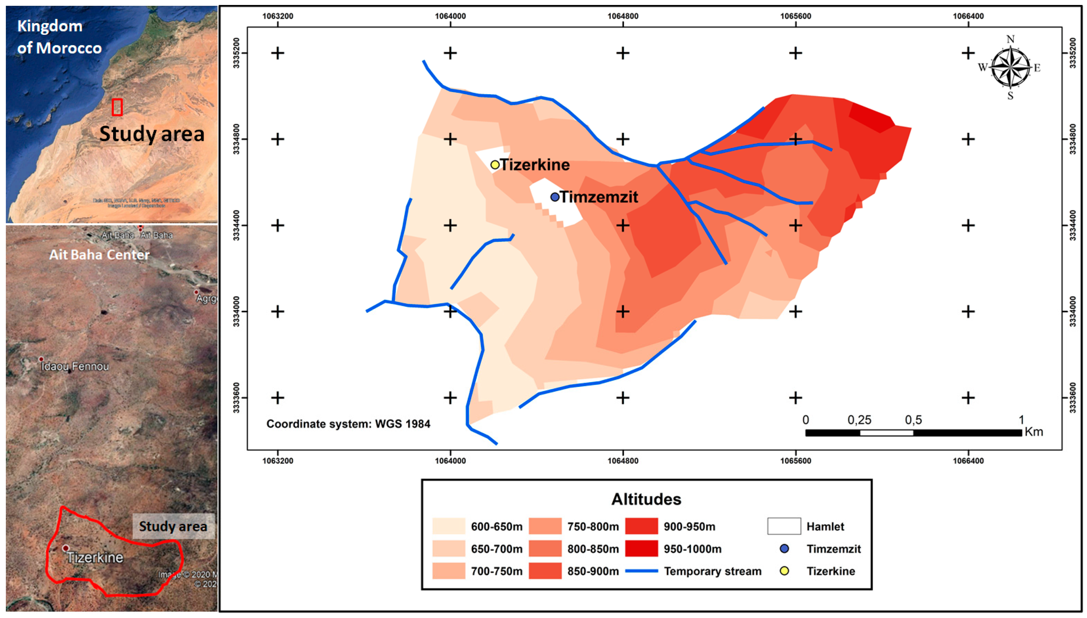
Figure 2.
Mapping of the age of abandonment of the terraces in the villages of Tizerkine and Timzemzit, Ait Baha, Western Anti-Atlas, Morocco.
Figure 2.
Mapping of the age of abandonment of the terraces in the villages of Tizerkine and Timzemzit, Ait Baha, Western Anti-Atlas, Morocco.
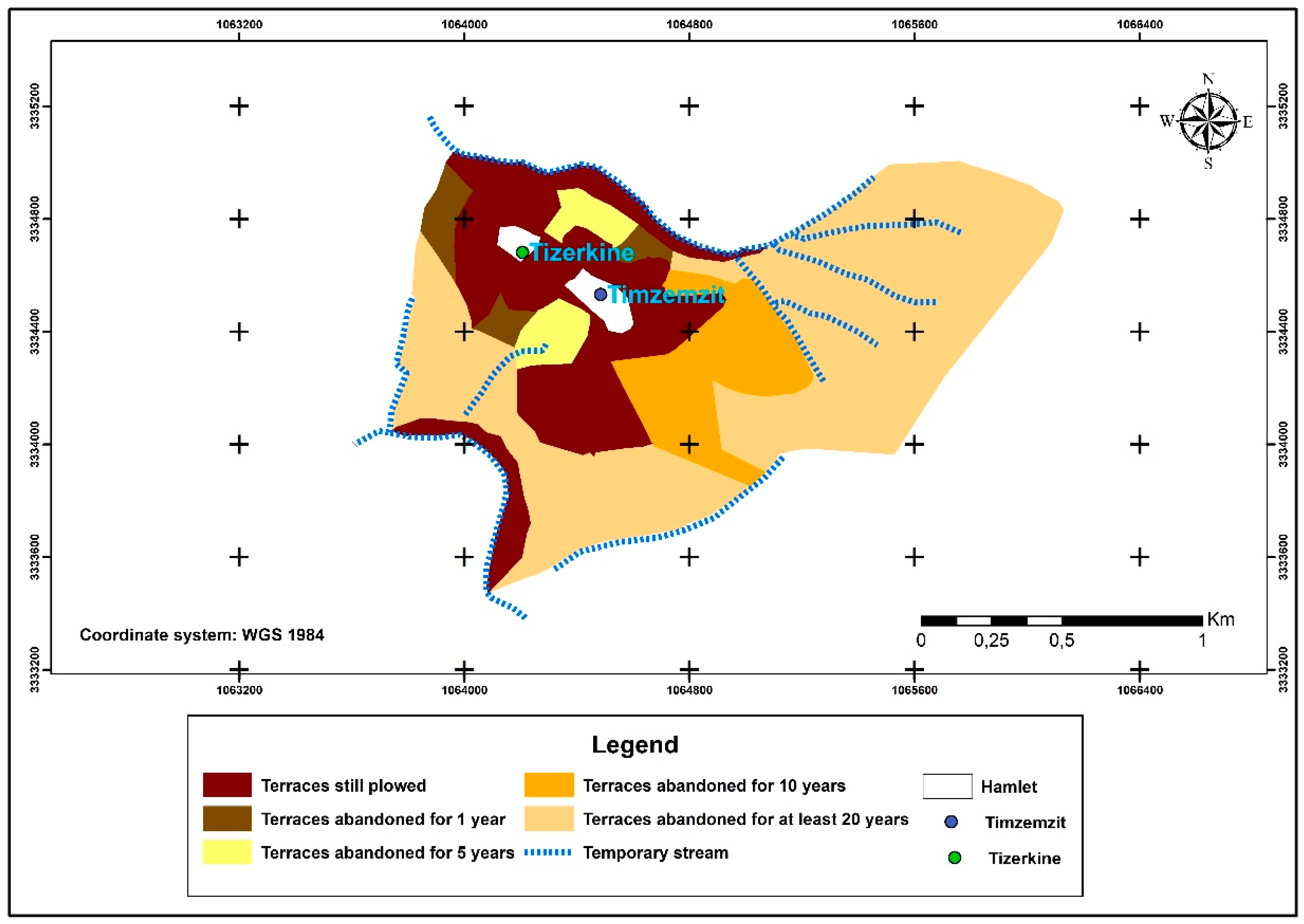
Figure 3.
States of the terraces in the territory of Tizerkine–Timzemzit.

Figure 4.
Water infiltration curves in the soil according to the age of abandonment of the terraces in the village of Tizerkine and Timzemzit, Ait Baha, Western Anti-Atlas, Morocco.
Figure 4.
Water infiltration curves in the soil according to the age of abandonment of the terraces in the village of Tizerkine and Timzemzit, Ait Baha, Western Anti-Atlas, Morocco.

Figure 5.
The average change in the SSF according to the years of abandonment of the terraces in the hamlets of Tizerkine and Timzemzit, Ait Baha, Western Anti-Atlas, Morocco.
Figure 5.
The average change in the SSF according to the years of abandonment of the terraces in the hamlets of Tizerkine and Timzemzit, Ait Baha, Western Anti-Atlas, Morocco.


Table 1.
The 5 age groups of abandonment of terraces in the territories of Tizerkine and Timzemzit, Western Anti-Atlas, Morocco.
Table 1.
The 5 age groups of abandonment of terraces in the territories of Tizerkine and Timzemzit, Western Anti-Atlas, Morocco.
| Class | States of the Terraces | Number of Years of Abandonment |
|---|---|---|
| 1 | Good state of conservation | 0 |
| 2 | Medium | 1 |
| 3 | Degraded | 5 |
| 4 | Very degraded | 10 |
| 5 | Collapsed | >20 |
Table 2.
Degrees of erosion as a function of the soil surface factor (SSF) [13].
Table 2.
Degrees of erosion as a function of the soil surface factor (SSF) [13].
| SSF | Degree of Erosion |
|---|---|
| 0–20 | Stable |
| 21–40 | Low |
| 41–60 | Moderate |
| 61–80 | Critical |
| 91–100 | Severe |
Table 3.
Evolution of the areas of abandoned terraces in the territory of Tizerkine and Timzemzit, Ait Baha, Western Anti-Atlas, Morocco.
Table 3.
Evolution of the areas of abandoned terraces in the territory of Tizerkine and Timzemzit, Ait Baha, Western Anti-Atlas, Morocco.
| Abandoned Terraces Ages | Area (ha) | % |
|---|---|---|
| Terraces still plowed (2017/18) | 70.7 | 24.9 |
| Terraces abandoned for 1 year | 9.4 | 3.3 |
| Terraces abandoned for 5 years | 11.1 | 3.9 |
| Terraces abandoned for 10 years | 33.1 | 11.7 |
| Terraces abandoned for at least 20 years | 159.7 | 56.2 |
| Total | 284 | 100.0 |
Table 4.
Evolution of the soil surface condition according to the age of abandonment of the terraces in the village of Tizerkine, Anti-Atlas.
Table 4.
Evolution of the soil surface condition according to the age of abandonment of the terraces in the village of Tizerkine, Anti-Atlas.
| Ages of Abandonment of Terraces | Average of the Surface Parameters | |||||||
|---|---|---|---|---|---|---|---|---|
| OS % | s | VC % | s | PEN kg/cm² | s | db g/cm3 | s | |
| Terraces still plowed (2017/18) | 75.8 a | 20.4 | 55.6 a | 5.5 | 1.0 a | 0.1 | 1.1 a | 0.1 |
| Terraces abandoned for 1 year | 54.3 b | 31.6 | 36.4 b | 6.7 | 1.2 b | 0.2 | 1.1 a | 0.1 |
| Terraces abandoned for 5 years | 25.3 c | 8.5 | 19.6 c | 2.4 | 1.7 c | 0.1 | 1.3 b | 0.2 |
| Terraces abandoned for 10 years | 12.4 d | 5.3 | 20.3 c | 5.2 | 1.6 c | 0.2 | 1.3 b | 0.1 |
| Terraces abandoned for at least 20 years | 11.5 d | 4.0 | 15.2 c | 3.2 | 1.7 c | 0.2 | 1.4 b | 0.2 |
OS: open surface; VC: covered surface; PEN: penetration resistance; db: bulk density of soil; s: standard deviation. a,b,c,d: the values of the same column followed by the same letter are not significantly different (α = 5%).
Table 5.
Evolution of the average final infiltration capacity (if) according to the age of abandonment of the terraces in the villages of Tizerkine and Timzemzit, Ait Baha, Western Anti-Atlas, Morocco.
Table 5.
Evolution of the average final infiltration capacity (if) according to the age of abandonment of the terraces in the villages of Tizerkine and Timzemzit, Ait Baha, Western Anti-Atlas, Morocco.
| Ages of Abandonment of Terraces | if (mm/h) | Standard Deviation (mm/h) | Coefficient of Variation (%) |
|---|---|---|---|
| Terraces still plowed (2017/18) | 301.8 a | 105.8 | 35.06 |
| Terraces abandoned for 1 year | 129.6 b | 28.9 | 22.30 |
| Terraces abandoned for 5 years | 62.9 c | 14.9 | 23.69 |
| Terraces abandoned for 10 years | 60.9 c | 12.5 | 20.53 |
| Terraces abandoned for at least 20 years | 58.3 c | 10.6 | 18.18 |
a,b,c: the values followed by the same letter are not significantly different (α = 5%).
Publisher’s Note: MDPI stays neutral with regard to jurisdictional claims in published maps and institutional affiliations. |
© 2021 by the author. Licensee MDPI, Basel, Switzerland. This article is an open access article distributed under the terms and conditions of the Creative Commons Attribution (CC BY) license (http://creativecommons.org/licenses/by/4.0/).
Share and Cite
MDPI and ACS Style
Sabir, M. The Terraces of the Anti-Atlas: From Abandonment to the Risk of Degradation of a Landscape Heritage. Water 2021, 13, 510. https://doi.org/10.3390/w13040510
AMA Style
Sabir M. The Terraces of the Anti-Atlas: From Abandonment to the Risk of Degradation of a Landscape Heritage. Water. 2021; 13(4):510. https://doi.org/10.3390/w13040510
Chicago/Turabian StyleSabir, Mohamed. 2021. "The Terraces of the Anti-Atlas: From Abandonment to the Risk of Degradation of a Landscape Heritage" Water 13, no. 4: 510. https://doi.org/10.3390/w13040510
Note that from the first issue of 2016, this journal uses article numbers instead of page numbers. See further details here.