System Dynamics Applied to Terraced Agroecosystems: The Case Study of Assaragh (Anti-Atlas Mountains, Morocco)

 ,
,  , ,
, ,  , and
, and
Abstract
1. Introduction
2. Materials and Methods
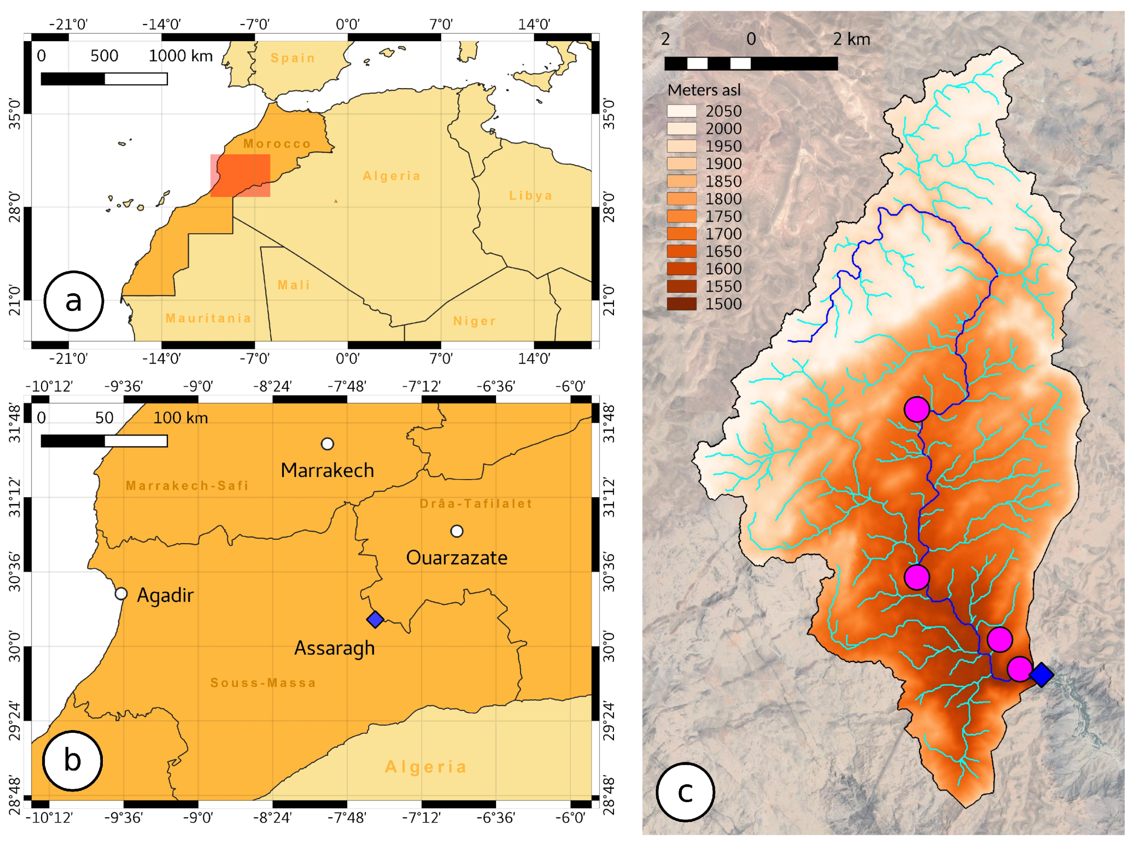
2.1. Case Study
2.1.1. General Overview
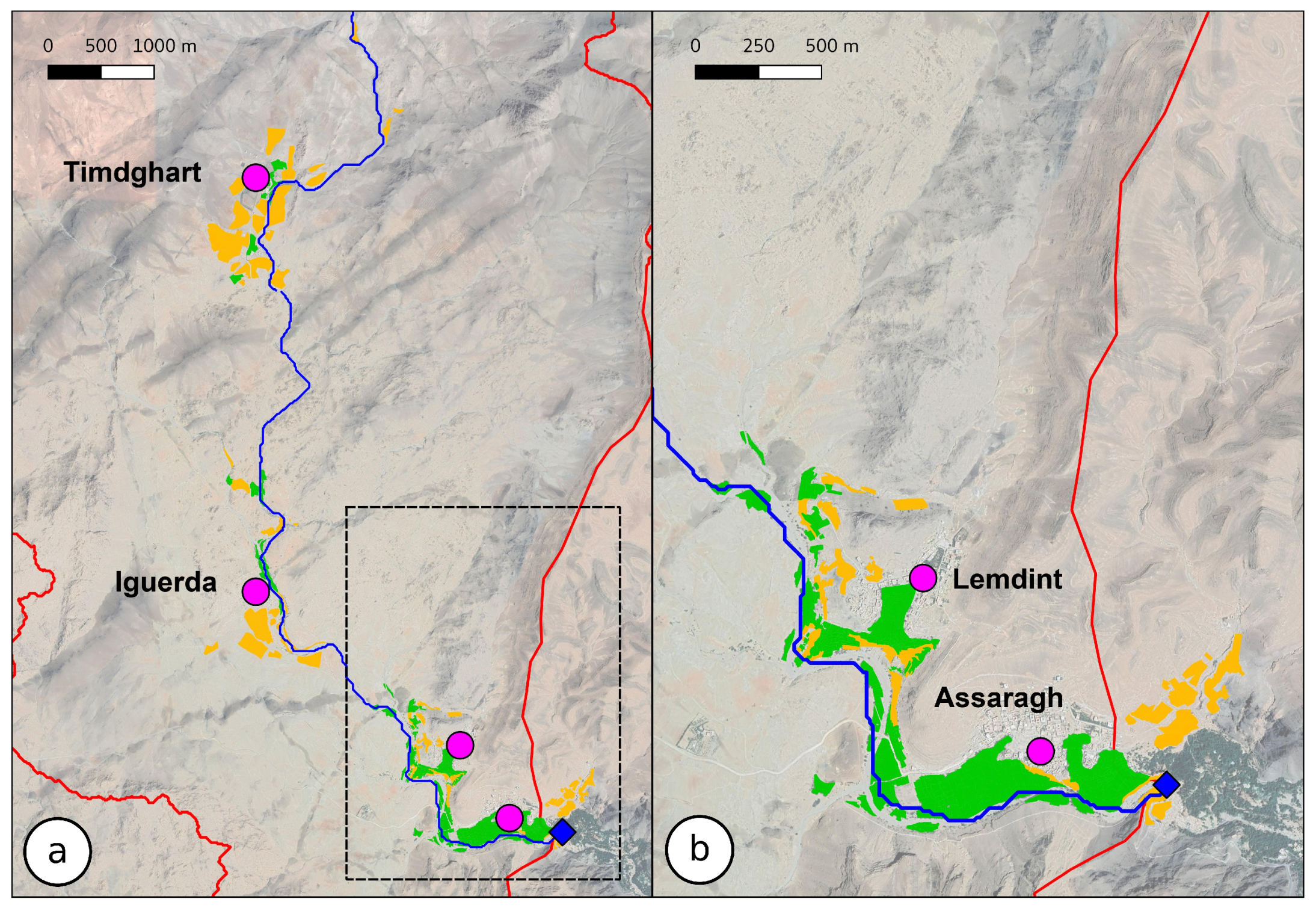
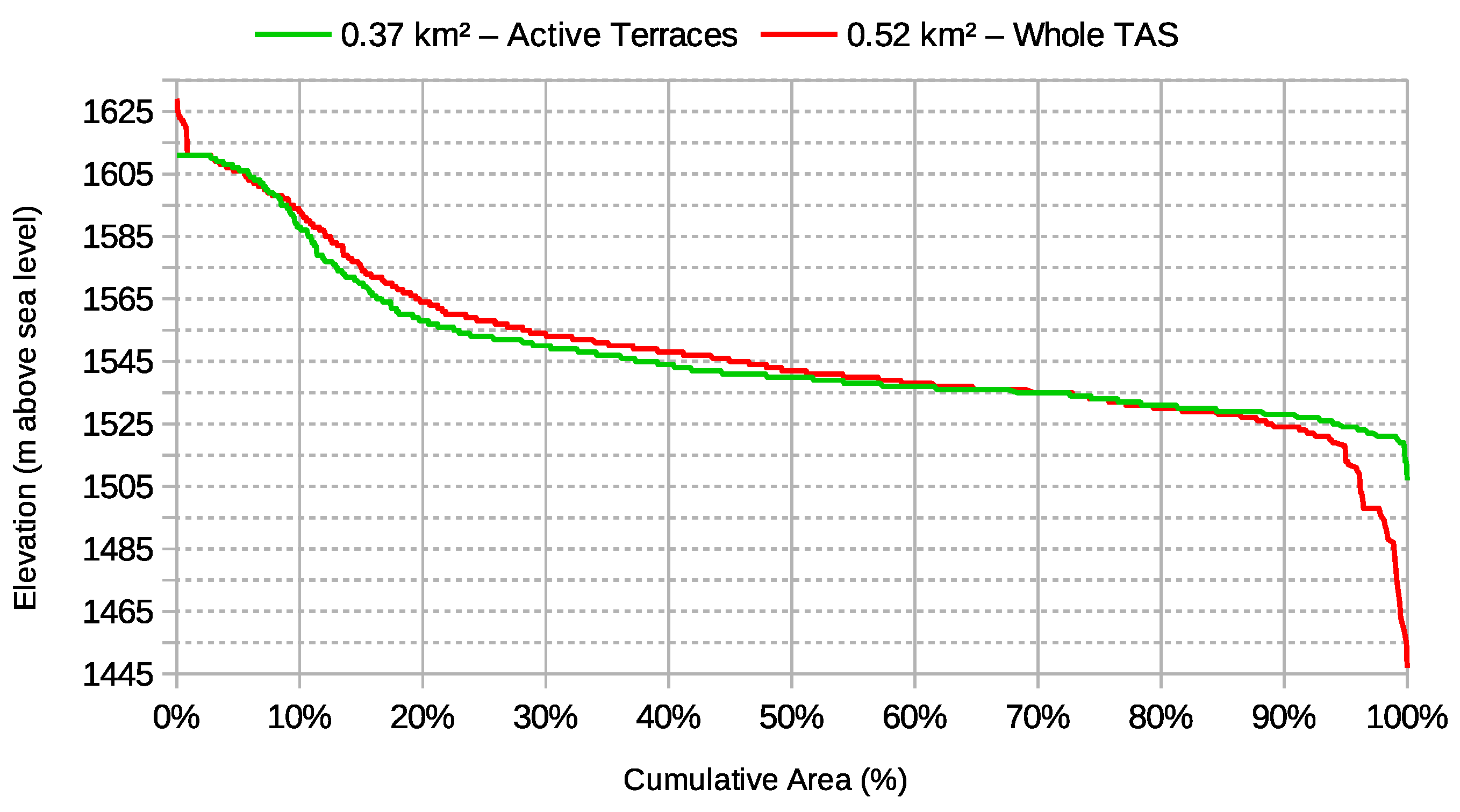
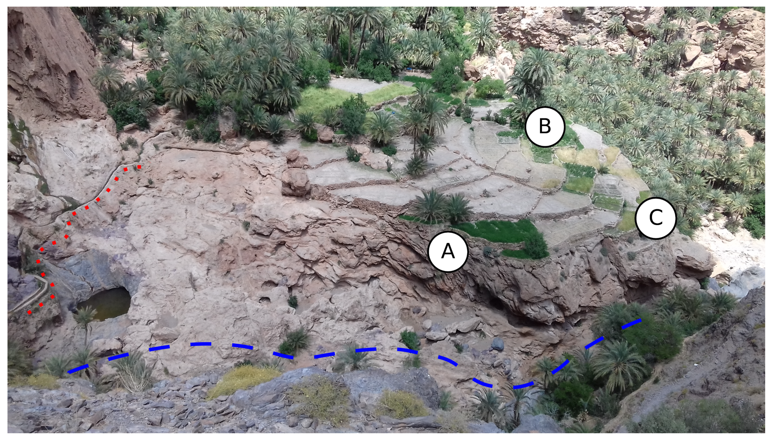
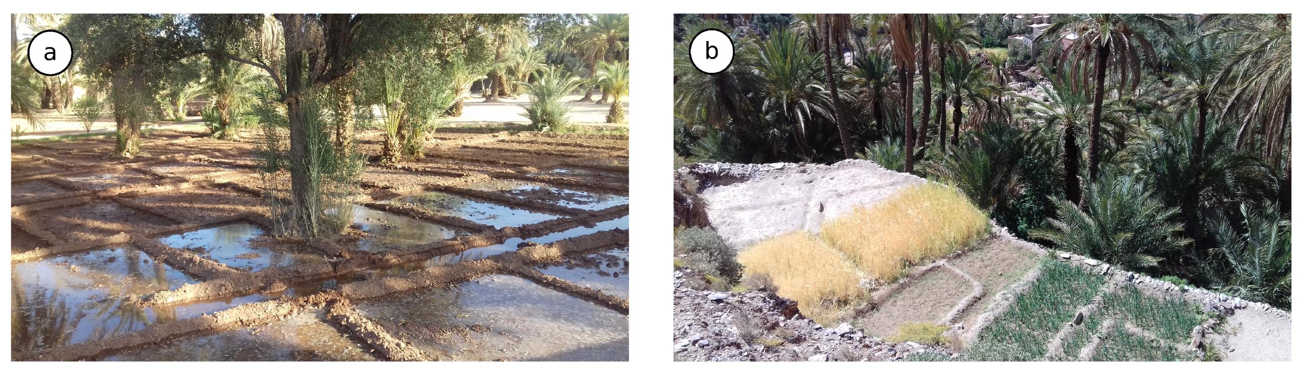
2.1.2. The Assaragh TAS
2.2. Conceptualization of the Case Study through SD
2.2.1. Definition of SD
2.2.2. Modelling Process
2.2.3. Selected Literature Review on Water Resources and Ecosystems Related Problems
2.2.4. The Model for Assaragh Case Study
2.3. Data Collection
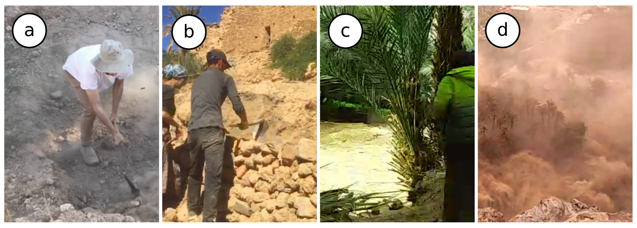
2.3.1. Field Surveys and Unstructured Data Collection
2.3.2. Terrain, Meteorological and Demographic Data
2.3.3. Structured Data Collection
2.4. Data Analysis
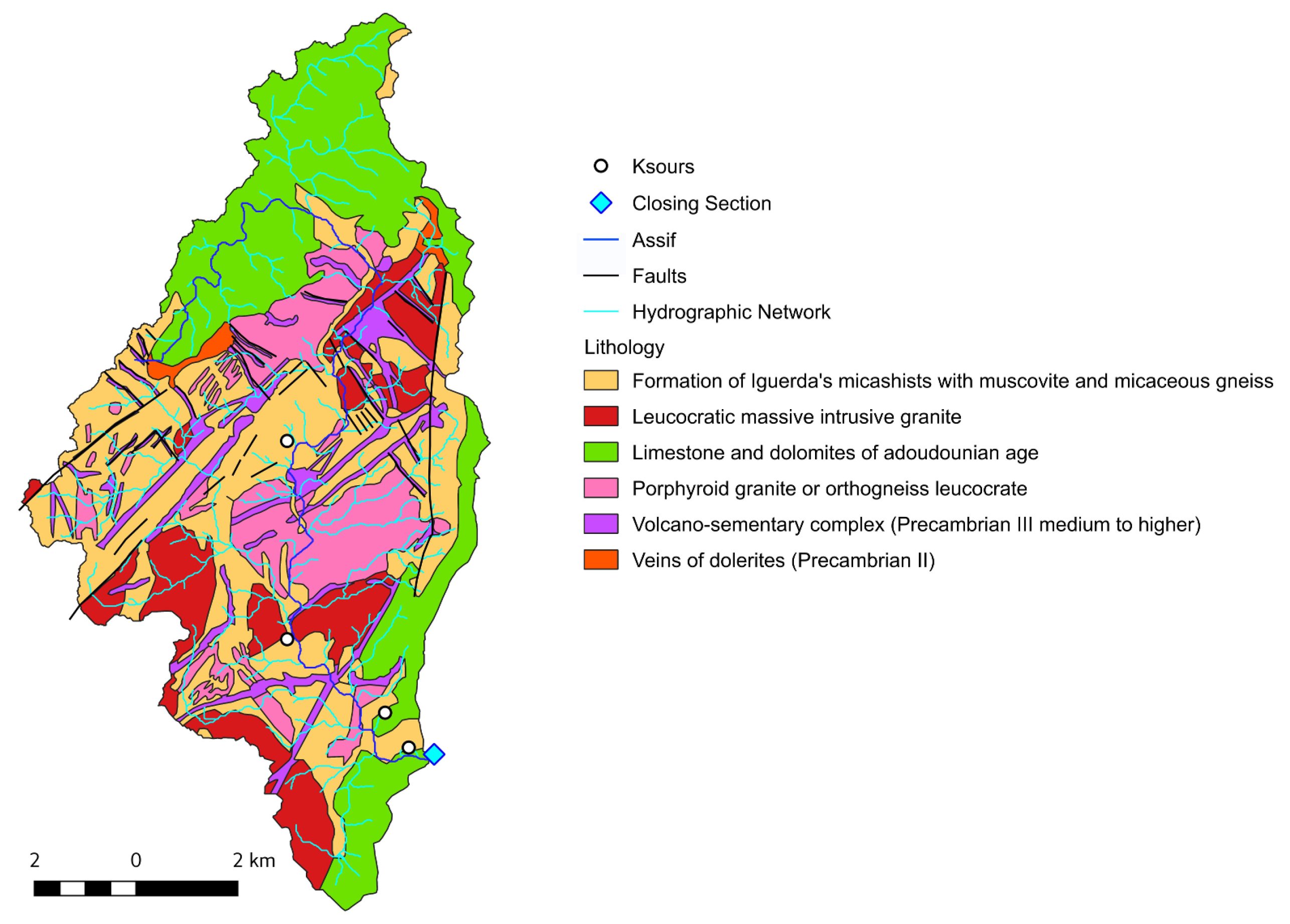
2.4.1. Geological Data
2.4.2. Climatic Data
2.4.3. Water Resources Balance
2.4.4. Demographic Data
2.4.5. Agrobiodiversity Assessment
- The main and superior tree layer is mainly composed by palm trees (Phoenix dactylifera). Moroccan oasis are known by their important varietal and genetic diversity of date palm trees [75,76,77,78], in fact Moroccan oases present more than 220 known varieties [79]. Palm trees on one side shade the plots and protect them from wind reducing soil dissecation; they provide mechanical protection from soil erosion and once dead they can be used as construction material for terraces and irrigation channels. Moreover they supply fodder to sheep and cattle that are raised in enclosures and fed with palm leaves mixed with alfalfa and vegetable waste. Several studies have shown essential and diverse bacterial communities associated with root palm tree systems [80,81]. The main arboreal layer close to wadi banks, in some spots, hosts ancient specimens of Celtis australis, Populus alba and Populus nigra as they can naturally occur where the hyporheic flow is more present.
- The secondary arboreal layer is composed mainly by seven species of cultivated tree: olive (Olea europaea), almond (Prunus dulcis), apricot (Prunus armeniaca) pomegranate (Punica granatum), carob (Ceratonia siliqua), fig (Ficus carica) and apple (Malus pumila). The olive tree, identified by the farmers under the denomination of ‘Zitoune’ and the almond tree are the dominant species in the secondary layer. The olive variety Zitoune has been previously identified by genetic markers as ‘Picholine marocaine’ [82]. It is widely spread in Moroccan agroecosystems and largely appreciated by local farmers [11,83]. The preference for olive and almond trees is in agreement with what has been observed by Belarbi et al. [84] in Aoufouss oasis (South of Morocco).
- The herbaceous layer hosts two species of cereals, wheat (Triticum turgidum), known locally under the denomination of ’Amazigh’, and barley (Hordeum vulgare). This layer is dominated by alfalfa (Medicago sativa) used as fodder, and by eight types of vegetable plants destined for local consumption: tomato (Solanum lycopersicum), onion (Allium cepa), carrot (Daucus carota), eggplant (Solanum melongena), faba bean (Vicia faba), courgette (Cucurbita pepo), green pepper (Capsicum annuum) and leek (Allium ampeloprasum). Therefore, association of wheat and barley with other crops was found to be beneficial for sustainable agricultural practices [85]. Assaragh is known also for the production of high quality saffron (Crocus sativus), which is not possible to cultivate downstream of Assaragh, in the Aguinane TAS at an altitude of 300 m lower.
3. Results
3.1. Geology Influences on TAS Structure
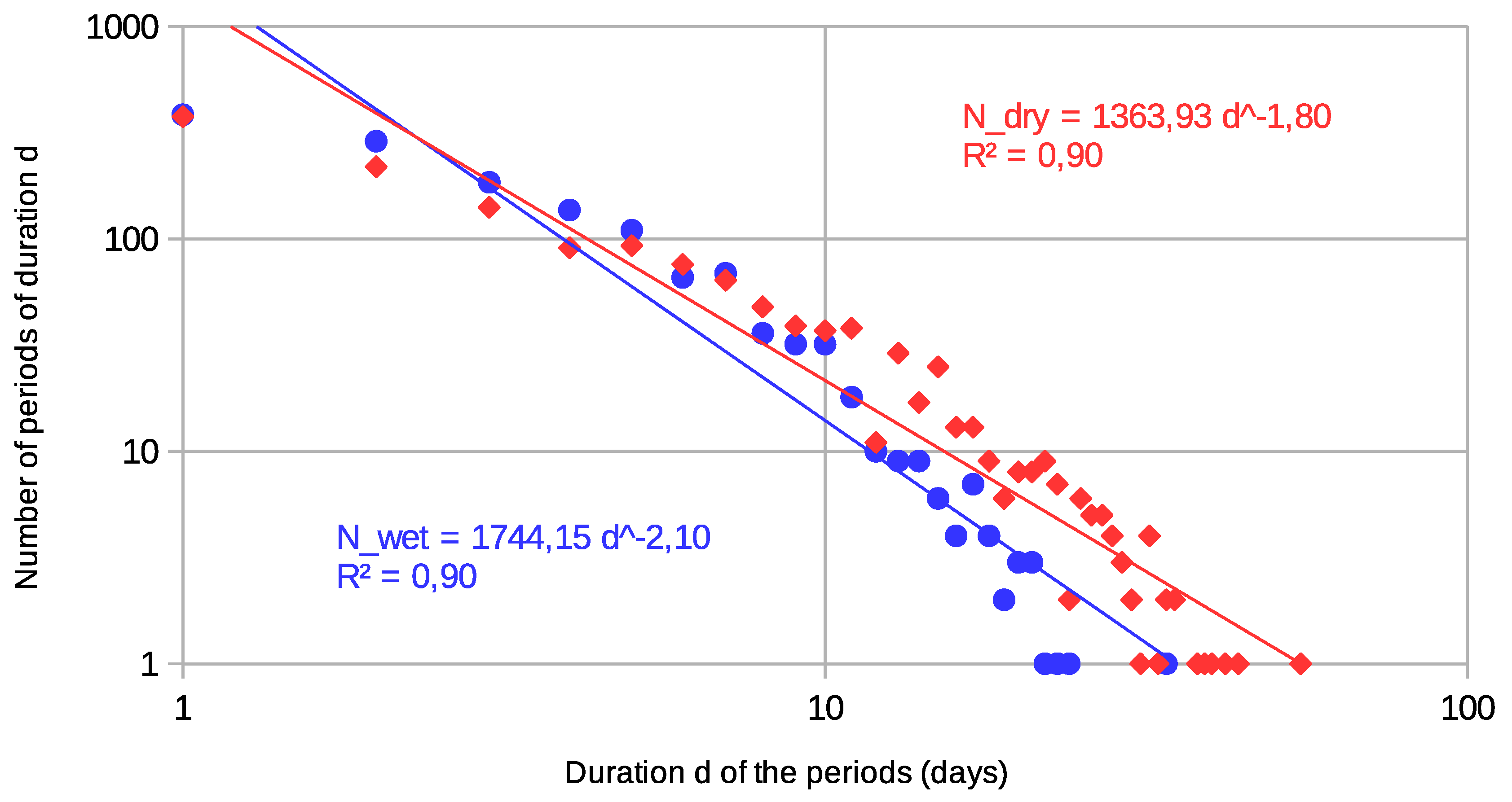
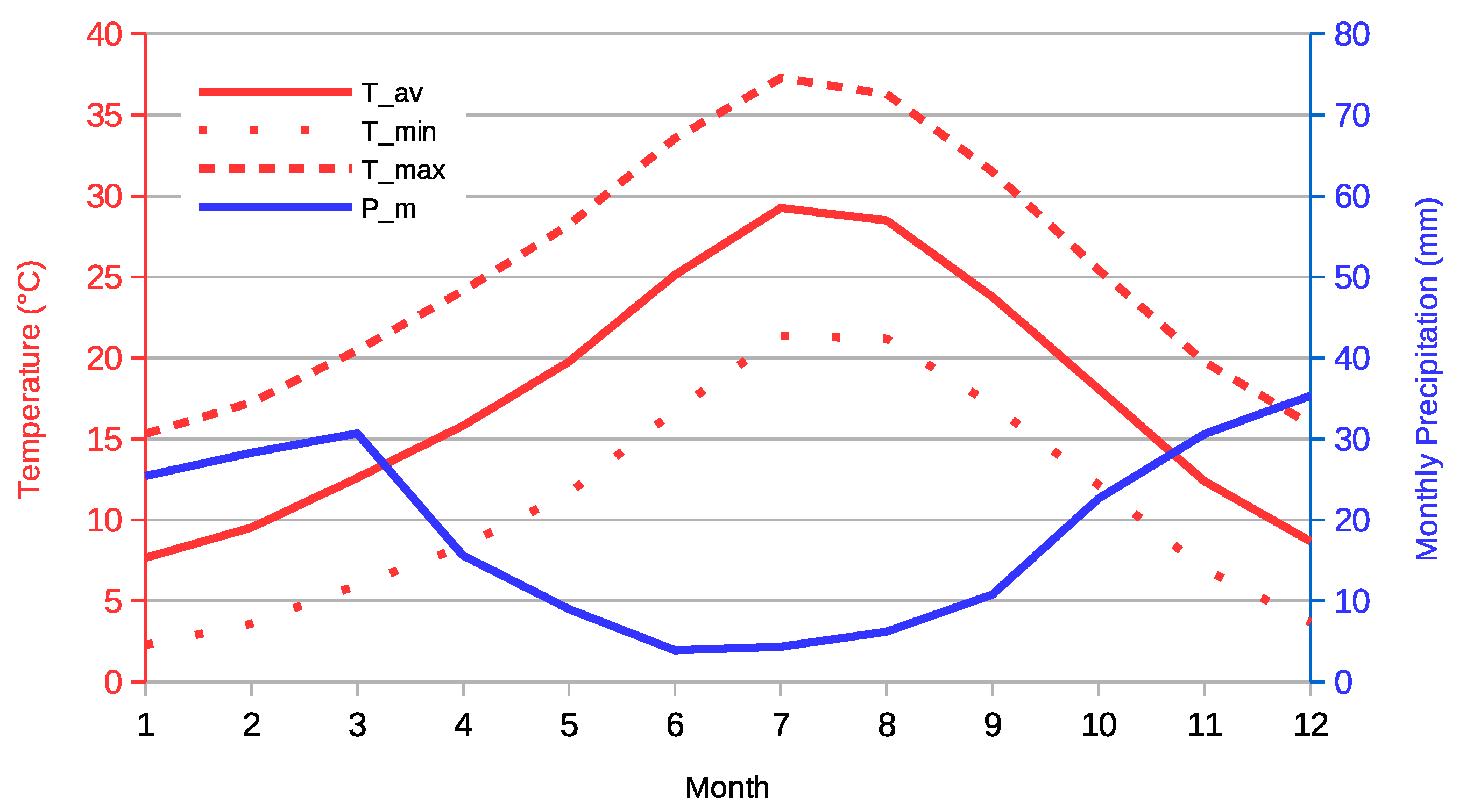
3.2. Climatic Trends and Rainy Days Reduction
3.3. Water Balance at the Basin Scale
3.4. Perception of Groundwater Resources
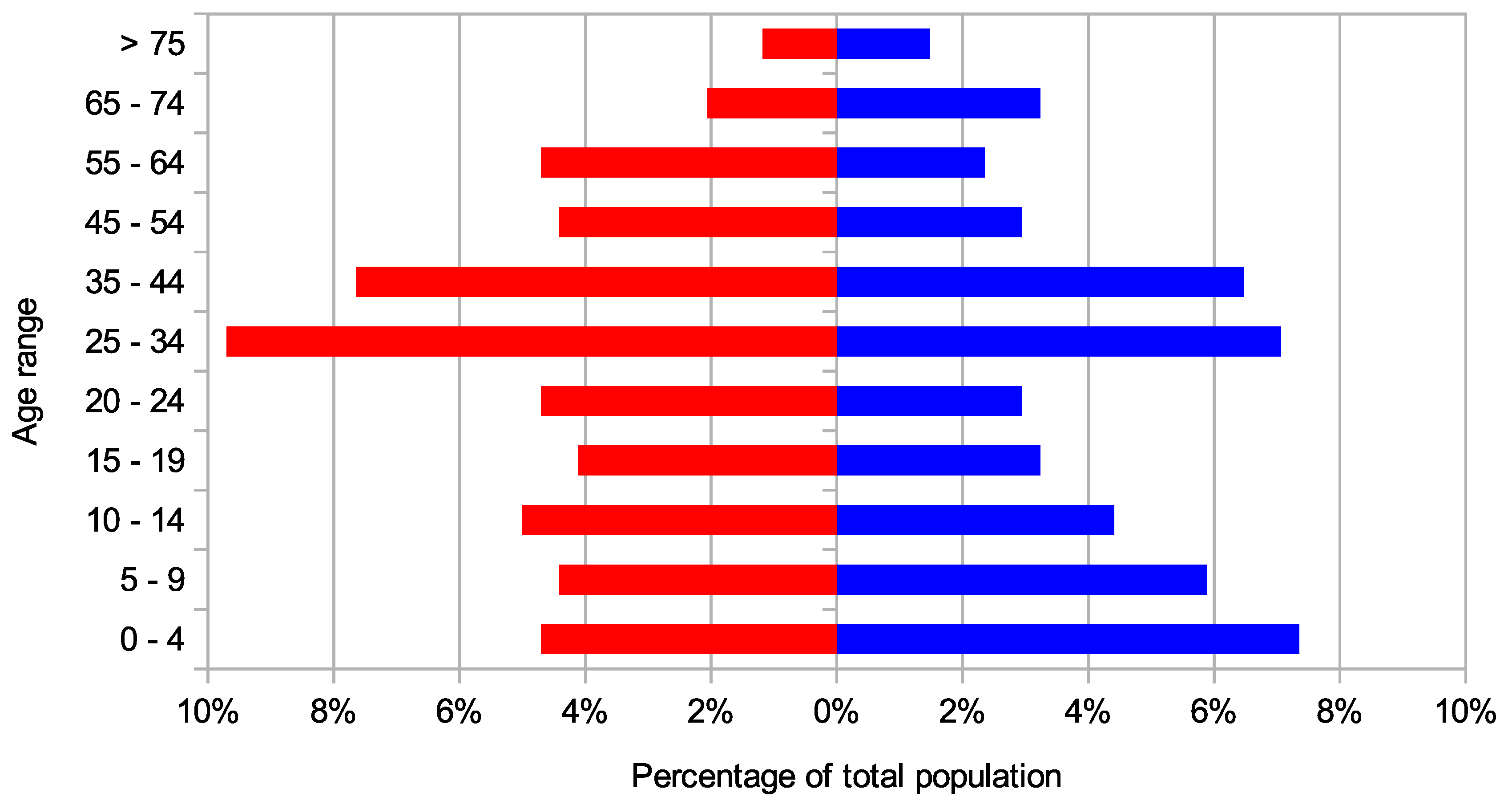
3.5. Demographic, Social and Cultural Dynamics
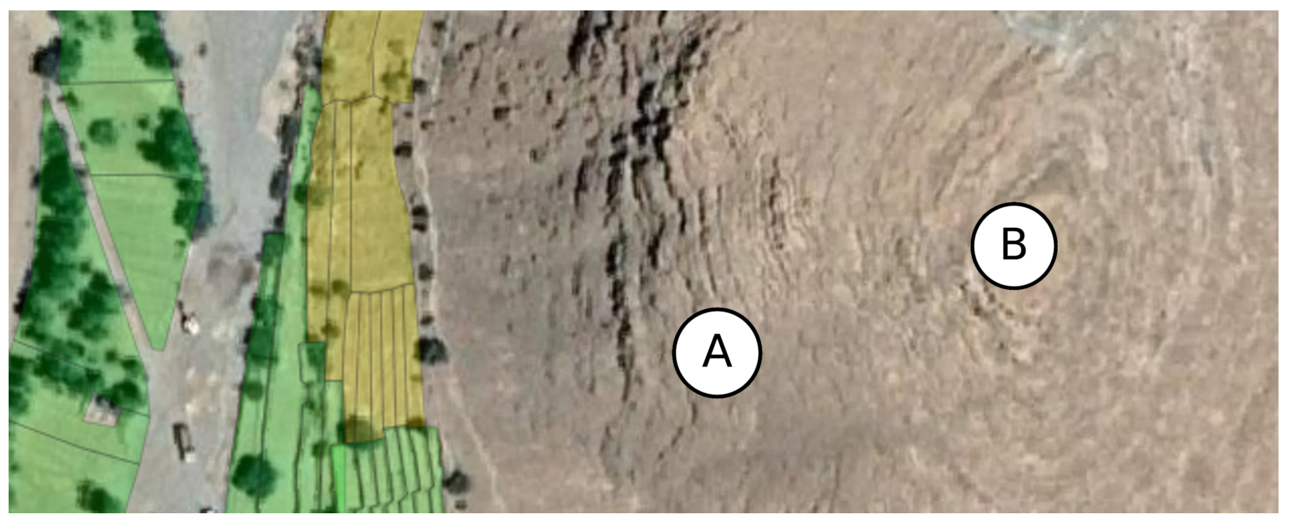
3.6. Mechanical Limitation of TAS Linked To Plant Growth
3.7. Global Dynamics Overview and Trends
4. Discussion
4.1. Possible Actions for Local Initiatives and Policy Makers
- Local primary schools that are generally present in the small ksour community, can offer many possibilities of developing programs aimed at environmental and scientific education based on situated learning in the TAS. There is a vast literature on such experiences [94,95,96,97]. In fact, situated learning is useful not only to teach basic scientific notions, but to promote cultural exchange, as well. Moreover, school activities related to traditional agriculture and irrigation practices can help to build and reinforce the identity of young people [20] hence preserving local culture and developing the social potential of new generations.
- The fundamental role of women in preserving crop productivity, traditional knowledge and achieving food security worldwide in rural communities has been widely recognized by the scientific community [98,99,100,101]. This is also valid in Amazigh communities [102] which today are observing a new rise of women involvement in local politics and social activism [103], thanks also to a process of modernization of a society which has become extremely patriarchal, following historical processes of social and cultural evolution [54]. However, in the past the Amazigh society has always had great female leaders who at times have emerged even in the historical periods most unfavorable to the emancipation of women [103]. In this sense the first action suggested views the empowerment of women in primary education, cultural exchange, TAS management and varieties selection, as a natural following action to take in order to consolidate the expected outcomes of the first one.
- The need for continuous communication and research of innovative educational and participatory tools to interest the new generations and render the actions of women and local communities more effective is vital. In this way the academic community can play a fundamental role through citizen science activities [104,105], in order to empower the two proposed actions. In fact, the third action consists in the creation of scientific participated laboratories in rural communities, laboratories that, in addition to promoting educational methodologies related to the environment and STEMs, promote citizen science projects aimed at the selection and the exchange of plant varieties suitable for future climate scenarios [106,107,108].
4.2. Strengths and Limitations of SD
5. Conclusions
Author Contributions
Funding
Acknowledgments
Conflicts of Interest
Abbreviations
| CLD | Casual Loop Diagram |
| LRWH | Landscape Restoration and Water Harvesting |
| MGP | Morocco Green Plan |
| SD | System Dynamics |
| SMTC | Soil-Moisture Temperature Coupling |
| TAS | Terraced Agroecosystem |
Appendix A. Glossary from Wadi Hydrology
| Wadi: | It refers to a dry (ephemeral) riverbed or creek, in climates ranging from hyper-arid to sub-arid, that contains water only when heavy rain occurs and can present hyporheic flow during the rest of the year. |
| Assif: | It refers to the main branch of the hydrographic network and can be considered as the main wadi. |
| Amot: | Generally it is the closing section. In the case of an endorheic basin it coincides with the area that collects the outflow. |
| Khettara: | It is the local version of a qanat (Remini 2015 [109]), and it is made by a gently sloping underground channel to transport water from an aquifer or water well to the surface; this technique does not stress the aquifer, naturally draining it, avoiding forced water withdrawal. |
Appendix B. Demographic Details

| Demography | Occupational Status for at Least 15 Years (%) | ||||||||||
|---|---|---|---|---|---|---|---|---|---|---|---|
| Ksour | Pop. | Families | M | F | Empr. | Free. | Publ. | Empl. | Fami. | Coop. | Other |
| Timdghart | 340 | 64 | 161 | 179 | 0.0 | 42.9 | 1.9 | 25.7 | 27.6 | 1.9 | 0.0 |
| Iguerda | 289 | 48 | 142 | 147 | 0.0 | 6.8 | 2.3 | 39.4 | 0.8 | 50.0 | 0.8 |
| Lemdint | 403 | 86 | 170 | 233 | 0.0 | 48.3 | 1.7 | 14.5 | 35.5 | 0.0 | 0.0 |
| Assaragh | 298 | 60 | 141 | 157 | 0.0 | 42.9 | 1.9 | 25.7 | 27.6 | 1.9 | 0.0 |
| Fifred | 471 | 89 | 214 | 257 | 2.1 | 8.2 | 3.1 | 78.4 | 1.0 | 3.1 | 4.1 |
| Fighil | 264 | 53 | 119 | 145 | 0.0 | 25.0 | 9.4 | 50.0 | 0.0 | 15.6 | 0.0 |
| Azegza | 318 | 66 | 157 | 161 | 0.0 | 15.7 | 17.7 | 63.5 | 0.0 | 3.1 | 0.0 |
| Kiroute | 329 | 68 | 153 | 176 | 3.5 | 14.0 | 19.3 | 63.2 | 0.0 | 0.0 | 0.0 |
| Timzoughine | 163 | 36 | 77 | 86 | 0.0 | 19.2 | 11.5 | 57.7 | 7.7 | 0.0 | 3.8 |
Appendix C. Additional Calculations
| Formula | t | Formula Calibrated on: |
|---|---|---|
| Giandotti (1934) [111] | 5.6 h | North Italian basins with area between 170 and 70,000 km |
| Pilgrim and McDermott (1981) [112] | 4.1 h | Australian basins with area between 0.1 and 250 km |
| NRCS SCS (CN = 85) (1972) [110] | 3.3 h | Rural basins with maximum area of 16 km |
| NRCS SCS (CN = 99) (1972) [110] | 1.7 h | Rural basins with A maximum area of 16 km |
Appendix D. Unstructured Data Collection


Appendix E. Structured Data Collection
| (2.2) | A—How many times during the year is the wadi flooded? |
| (32) | B—How many days are rainy during the year? |
| (250) | C—How many people live in the oasis (Assaragh and Lemdint)? |
| (100) | D—How many people were living in the oasis (Assaragh and Lemdint) when you were a child (from 5 to 12 years old)? |
| (88) | E—How many days were rainy during the year when you were a child (from 5 to 12 years old)? |
| (32) | F—How many times during the year was the wadi flooded when you were a child (from 5 to 12 years old)? |
| (1.8) | 01—In general winters are colder with respect to the past. |
| (5.0) | 02—In general it rains less with respect to the past. |
| (2.3) | 03—In general there is more water available for agriculture. |
| (1.8) | 04—The quality of life in Assaragh is higher with respect to big cities such as Ouarzazate, Marrakech or Agadir. |
| (4.4) | 05—Many young people leave Assaragh to move to big cities or abroad. |
| (5.0) | 06—Summers are warmer with respect to the past. |
| (5.0) | 07—Assaragh had many more cultivated terraces in the past. |
| (5.0) | 08—The terraces were abandoned due to friction between the villagers. |
| (2.1) | 09—The terraces have been abandoned due to the drying up of the springs irrigating them. |
| (4.7) | 10—The abandonment of the terraces is a problem for the village. |
| (3.5) | 11—It is better to use wells with motor pumps than khettaras for irrigation. |
| (2.1) | 12—It is better to have a large field without trees than several small fields with many trees on the edge. |
| (4.2) | 13—Assaragh is much better than I remember in recent years. |
| (2.3) | 14—I have full confidence in the government’s agricultural development policies. |
| (1.0) | 15—People earn much more from farming than in the past. |
| (2.3) | 16—I am familiar with the phenomenon of climate change and I know what we are talking about when we talk about climate change. |
| (1.8) | 17—I would prefer to live in a big city. |
| (3.1) | 18—It is becoming more and more difficult to cultivate in the oasis. |
| (5.0) | 19—Climate change will result in a generally warmer and drier climate. |
| (5.0) | 20—Morocco will not be particularly affected by climate change. |
| Entry | 01 | 02 | 03 | 04 | 05 | 06 | 07 | 08 | 09 | 10 | 11 | 12 | 13 | 14 | 15 |
|---|---|---|---|---|---|---|---|---|---|---|---|---|---|---|---|
| Age | 57 | 66 | 62 | 68 | 75 | 69 | 70 | 45 | 77 | 62 | 61 | 58 | 41 | 56 | 62 |
| Sex | F | M | M | M | F | M | M | M | M | M | M | M | M | M | F |
| A | 2/3 | 1/3 | 2/3 | 2/3 | 1/3 | 2/3 | 2/3 | 1/3 | 1/3 | 1/3 | 1/3 | 1/3 | 1/3 | 1/3 | 1/3 |
| B | 30 | 35 | 30 | 40 | 30 | 30 | 40 | 30 | 30 | 30 | 30 | 30 | 30 | 30 | 35 |
| C | 250 | 250 | 250 | 250 | 250 | 250 | 250 | 250 | 250 | 250 | 250 | 250 | 250 | 250 | 250 |
| D | 100 | 100 | 100 | 100 | 100 | 100 | 100 | 100 | 100 | 100 | 100 | 100 | 100 | 100 | 100 |
| E | 90 | 105 | 60 | 90 | 120 | 105 | 120 | 60 | 90 | 90 | 90 | 60 | 60 | 90 | 90 |
| F | 35 | 45 | 35 | 45 | 55 | 35 | 45 | 35 | 35 | 35 | 35 | 35 | 30 | 35 | 35 |
| 01 | 5 | 5 | 1 | 1 | 5 | 1 | 1 | 1 | 1 | 1 | 1 | 1 | 1 | 1 | 1 |
| 02 | 5 | 5 | 5 | 5 | 5 | 5 | 5 | 5 | 5 | 5 | 5 | 5 | 5 | 5 | 5 |
| 03 | 1 | 1 | 1 | 1 | 5 | 5 | 5 | 5 | 1 | 1 | 5 | 1 | 1 | 1 | 1 |
| 04 | 1 | 1 | 1 | 1 | 5 | 5 | 5 | 1 | 1 | 1 | 1 | 1 | 1 | 1 | 1 |
| 05 | 4 | 4 | 4 | 4 | 3 | 4 | 5 | 4 | 4 | 5 | 5 | 5 | 5 | 5 | 5 |
| 06 | 5 | 5 | 5 | 5 | 5 | 5 | 5 | 5 | 5 | 5 | 5 | 5 | 5 | 5 | 5 |
| 07 | 5 | 5 | 5 | 5 | 5 | 5 | 5 | 5 | 5 | 5 | 5 | 5 | 5 | 5 | 5 |
| 08 | 5 | 5 | 5 | 5 | 5 | 5 | 5 | 5 | 5 | 5 | 5 | 5 | 5 | 5 | 5 |
| 09 | 1 | 1 | 1 | 1 | 5 | 1 | 5 | 1 | 5 | 1 | 1 | 1 | 1 | 5 | 1 |
| 10 | 5 | 1 | 5 | 5 | 5 | 5 | 5 | 5 | 5 | 5 | 5 | 5 | 5 | 5 | 5 |
| 11 | 1 | 5 | 5 | 5 | 1 | 5 | 1 | 4 | 1 | 4 | 5 | 1 | 4 | 5 | 5 |
| 12 | 1 | 5 | 5 | 1 | 1 | 1 | 1 | 1 | 1 | 5 | 1 | 1 | 1 | 5 | 1 |
| 13 | 5 | 5 | 5 | 5 | 1 | 1 | 5 | 1 | 5 | 5 | 5 | 5 | 5 | 5 | 5 |
| 14 | 1 | 5 | 5 | 5 | 1 | 5 | 1 | 1 | 1 | 1 | 1 | 1 | 5 | 1 | 1 |
| 15 | 1 | 1 | 1 | 1 | 1 | 1 | 1 | 1 | 1 | 1 | 1 | 1 | 1 | 1 | 1 |
| 16 | 1 | 5 | 5 | 5 | 1 | 5 | 1 | 1 | 1 | 1 | 1 | 1 | 5 | 1 | 1 |
| 17 | 1 | 5 | 1 | 1 | 1 | 1 | 1 | 1 | 1 | 1 | 1 | 1 | 5 | 1 | 5 |
| 18 | 5 | 5 | 5 | 5 | 1 | 5 | 1 | 1 | 1 | 1 | 1 | 1 | 5 | 5 | 5 |
| 19 | 5 | 5 | 5 | 5 | 5 | 5 | 5 | 5 | 5 | 5 | 5 | 5 | 5 | 5 | 5 |
| 20 | 5 | 5 | 5 | 5 | n.a. | 5 | 5 | 5 | 5 | 5 | 5 | 5 | 5 | 5 | 5 |
References
- Healy, P.F.; Lambert, J.D.H.; Arnason, J.T.; Hebda, R.J. Caracol, Belize: Evidence of Ancient Maya Agricultural Terraces. J. Field Archaeol. 1983, 10, 397–410. [Google Scholar] [CrossRef]
- Sandor, J.A. Ancient agricultural terraces and soils. In Footprints in the Soil: People and Ideas in Soil History; Warkentin, B., Ed.; Elsevier: New York, NY, USA, 2006; pp. 505–534. [Google Scholar]
- Petit, C.; Konold, W.; Höchtl, F. Historic terraced vineyards: Impressive witnesses of vernacular architecture. Landsc. Hist. 2012, 33, 5–28. [Google Scholar] [CrossRef]
- Martin, C. Espaces en Terrasses et Prévention de Risques Naturels en Cévennes; Maison de la Géographie: Montpellier, France, 2006. [Google Scholar]
- Puy, A.; García Avilés, J.M.; Balbo, A.L.; Keller, M.; Riedesel, S.; Blum, D.; Bubenzer, O. Drip irrigation uptake in traditional irrigated fields: The edaphological impact. J. Environ. Manag. 2017, 202, 550–561. [Google Scholar] [CrossRef] [PubMed]
- Romero Martin, L.E.; Gonzalez Morales, A.; Ramon Ojeda, A. Towards a new valuation of cultural terraced landscapes: The heritage of terraces in the Canary Islands (Spain). ANNALES Ser. Hist. Sociol. 2016, 26, 499–512. [Google Scholar] [CrossRef]
- Ziyadi, M.; Dahbi, A.; Aitlhaj, A.; El Ouahrani, A.; El Ouahidi, A.; Achtak, H. Terraced Agroforestry Systems in West Anti-Atlas (Morocco): Incidence of Climate Change and Prospects for Sustainable Development. In Climate Change-Resilient Agriculture and Agroforestry; Springer: Berlin/Heidelberg, Germany, 2019; pp. 1–19. [Google Scholar] [CrossRef]
- Koohafkan, P.; Altieri, M.; Initiative, G. A Methodological Framework for the Dynamic Conservation of Agricultural Heritage Systems; Land and Water Division, The Food and Agriculture Organization (FAO) of the United Nations: Geneva, Switzerland, 2011; pp. 1–61. [Google Scholar]
- Koohafkan, P.; Altieri, M.A. Globally Important Agricultural Heritage Systems: A Legacy for the Future; Food and Agriculture Organization of the United Nations: Rome, Italy, 2011. [Google Scholar]
- UNESCO. UNESCO Examination of nominations for inscription in 2018 on the Representative List of the Intangible Cultural Heritage of Humanity. In Document ITH/18/13.COM/10.b; UNESCO: London, UK, 2018. [Google Scholar]
- Hmimsa, Y.; Ater, M. Agrodiversity in the traditional agrosystems of the Rif mountains (north of Morocco). Biodiversity 2008, 9, 78–81. [Google Scholar] [CrossRef]
- Tarolli, P.; Preti, F.; Romano, N. Terraced landscapes: From an old best practice to a potential hazard for soil degradation due to land abandonment. Anthropocene 2014, 6, 10–25. [Google Scholar] [CrossRef]
- Ater, M.; Hmimsa, Y. Agrodiversité des agroécosystèmes traditionnels du pays Jbala (Rif, Maroc) et produits de terroirs. In Indications Géographiques, Dynamiques Socio-Économiques et Patrimoine Bio-Culturel en Turquie et Dans les Pays Méditerranéens. Options Méditerranéennes A; Ilbert, H., Tekelioglu, Y., Çagatay, S., Tozanli, S., Eds.; CIHEAM: Antalya, Turkey, 2013; Volume 104, pp. 197–208. [Google Scholar]
- Nair, P. An Introduction to Agroforestry; Kluwer Academic Publishers: Dordrecht, The Netherlands, 1993; p. 499. [Google Scholar]
- De Haas, H. Migration and Agricultural Transformations in the Oases of Morocco and Tunisia; KNAG: Utrecht, The Netherlands, 2001. [Google Scholar]
- Myers, N.; Mittermeier, R.A.; Mittermeier, C.G.; Da Fonseca, G.A.B.; Kent, J. Biodiversity hotspots for conservation priorities. Nature 2000, 403, 853. [Google Scholar] [CrossRef]
- Brush, S.B. In situ conservation of landraces in centers of crop diversity. Crop Sci. 1995, 35, 346–354. [Google Scholar] [CrossRef]
- Achtak, H.; Ater, M.; Oukabli, A.; Santoni, S.; Kjellberg, F.; Khadari, B. Traditional agroecosystems as conservatories and incubators of cultivated plant varietal diversity: The case of fig (Ficus carica L.) in Morocco. BMC Plant Biol. 2010, 10, 28. [Google Scholar] [CrossRef]
- Liu, S.L.; Dong, Y.H.; Li, D.; Liu, Q.; Wang, J.; Zhang, X.L. Effects of different terrace protection measures in a sloping land consolidation project targeting soil erosion at the slope scale. Ecol. Eng. 2013, 53, 46–53. [Google Scholar] [CrossRef]
- Barontini, S.; Boselli, V.; Louki, A.; Ben Slima, Z.; Ghaouch, F.E.; Labaran, R.; Raffelli, G.; Peli, M.; Al Ani, A.M.; Vitale, N.; et al. Bridging Mediterranean cultures in the International Year of Soils 2015: A documentary exhibition on irrigation techniques in water scarcity conditions. Hydrol. Res. 2017, 48, 789–801. [Google Scholar] [CrossRef]
- Arnáez, J.; Lasanta, T.; Errea, M.P.; Ortigosa, L. Land abandonment, landscape evolution, and soil erosion in a Spanish Mediterranean mountain region: The case of Camero Viejo. Land Degrad. Dev. 2011, 22, 537–550. [Google Scholar] [CrossRef]
- Barrow, C.J.; Hicham, H. Two complimentary and integrated land uses of the western High Atlas Mountains, Morocco: The potential for sustainable rural livelihoods. Appl. Geogr. 2000, 20, 369–394. [Google Scholar] [CrossRef]
- Agnoletti, M.; Errico, A.; Santoro, A.; Dani, A.; Preti, F. Terraced landscapes and hydrogeological risk. Effects of land abandonment in Cinque Terre (Italy) during severe rainfall events. Sustainability 2019, 11, 235. [Google Scholar] [CrossRef]
- Kizos, T.; Koulouri, M.; Vakoufaris, H.; Psarrou, M. Preserving Characteristics of the Agricultural Landscape through Agri-Environmental Policies: The Case of Cultivation Terraces in Greece. Landsc. Res. 2010, 35, 577–593. [Google Scholar] [CrossRef]
- Fischer, J.; Hartel, T.; Kuemmerle, T. Conservation policy in traditional farming landscapes. Conserv. Lett. 2012, 5, 167–175. [Google Scholar] [CrossRef]
- Agnoletti, M.; Emanueli, F.; Errico, A.; Maggiari, G.; Santoro, A.; Preti, F. Terracing and hydrogeological risk. A study of the environmental disaster of 25 October 2011 in Cinque Terre. In Proceedings of the EGU General Assembly Conference, Vienna, Austria, 12–17 April 2015; Volume 17. [Google Scholar]
- Alejano, L.R.; Veiga, M.; Taboada, J.; Díez-Farto, M. Stability of granite drystone masonry retaining walls: I. Analytical design. Géotechnique 2012, 62, 1013–1025. [Google Scholar] [CrossRef]
- Galletti, C.S.; Ridder, E.; Falconer, S.E.; Fall, P.L. Maxent modeling of ancient and modern agricultural terraces in the Troodos foothills, Cyprus. Appl. Geogr. 2013, 39, 46–56. [Google Scholar] [CrossRef]
- Ruhl, J.; Pasta, S. Plant succession on Sicilian terraces. Ann. Di Bot. 2007, 7. [Google Scholar] [CrossRef]
- Martínez-Fernández, J.; Esteve-Selma, M.A.; Calvo-Sendín, J.F. Environmental and socioeconomic interactions in the evolution of traditional irrigated lands: A dynamic system model. Hum. Ecol. 2000, 28, 279–299. [Google Scholar] [CrossRef]
- Shahbazbegian, M.R.; Turton, A.; Mousavi Shafaee, S.M. Hydropolitical Self-Organization theory; system dynamics to analyse hydropolitics of Helmand transboundary river. Water Policy 2016, 18, 1088–1119. [Google Scholar] [CrossRef]
- Tenza, A.; Gutiérrez Pérez, I.; Martínez-Fernández, J.; Arregui Giménez, A. Understanding the decline and resilience loss of a long-lived social-ecological system: Insights from system dynamics. Ecol. Soc. 2017, 22, 15. [Google Scholar] [CrossRef]
- Di Baldassarre, G.; Wanders, N.; AghaKouchak, A.; Kuil, L.; Rangecroft, S.; Veldkamp, T.I.E.; Garcia, M.; van Oel, P.R.; Breinl, K.; Van Loon, A.F. Water shortages worsened by reservoir effects. Nat. Sustain. 2018, 1, 617–622. [Google Scholar] [CrossRef]
- Sušnik, J.; Vamvakeridou-Lyroudia, L.S.; Savić, D.A.; Kapelan, Z. Integrated System Dynamics Modelling for water scarcity assessment: Case study of the Kairouan region. Sci. Total Environ. 2012, 440, 290–306. [Google Scholar] [CrossRef] [PubMed]
- Forrester, J.W. System dynamics and the lessons of 35 years. In A Systems-Based Approach to Policymaking; De Greene, K.B., Ed.; Springer: Boston, MA, USA, 1993; pp. 199–240. [Google Scholar]
- Buytaert, W.; Friesen, J.; Liebe, J.; Ludwig, R. Assessment and management of water resources in developing, semi-arid and arid regions. Water Resour. Manag. 2012, 26, 841–844. [Google Scholar] [CrossRef]
- Barros, V.R.; Field, C.B. Climate Change 2014: Impacts, Adaptation, and Vulnerability. Part B: Regional Aspects; Cambridge University Press: Cambridge, UK, 2014. [Google Scholar]
- Approaches to the Implementation of the Two Pillars of the MGP. Available online: https://www.ada.gov.ma/en/approaches-implementation-two-pillars-green-morocco-plan (accessed on 30 May 2020).
- His Majesty King Mohammed VI Launches the New Agricultural Strategy ‘GENERATION GREEN 2020–2030’. Available online: https://www.ada.gov.ma/en/news/his-majesty-king-mohammed-vi-launches-new-agricultural-strategy-generation-green-2020-2030 (accessed on 30 May 2020).
- Jenkins, T.N. Putting postmodernity into practice: Endogenous development and the role of traditional cultures in the rural development of marginal regions. Ecol. Econ. 2000, 34, 301–313. [Google Scholar] [CrossRef]
- Schilling, J.; Freier, K.P.; Hertig, E.; Scheffran, J. Climate change, vulnerability and adaptation in North Africa with focus on Morocco. Agric. Ecosyst. Environ. 2012, 156, 12–26. [Google Scholar] [CrossRef]
- Emberger, L. Une Classification Biogéographique des Climats; Recueil, Travaux de Laboratoire Géolo-Zoologique, Faculté des Sciences, Service Botanique: Montpellier, France, 1955; Volume 7, pp. 3–43. [Google Scholar]
- Rankou, H.; Culham, A.; Jury, S.L.; Christenhusz, M.J.M. The endemic flora of Morocco. Phytotaxa 2013, 78, 1–69. [Google Scholar] [CrossRef]
- Benabid, A. Les Écosystèmes Forestiers, Préforestiers et Presteppiques du Maroc: Diversité, Répartition Biogéographique et Problèmes Posés par leur Aménagement; Forêt Méditerranéenne: Marseille, France, 1985. [Google Scholar]
- Benabid, A. Flore et Écosystèmes du Maroc: Evaluation et Préservation de la Biodiversité; Ibis Press: Paris, France, 2000. [Google Scholar]
- Senge, P.M. The Fifth Discipline Fieldbook: Strategies and Tools for Building a Learning Organization; Crown Business: New York, NY, USA, 2014. [Google Scholar]
- Richardson, G.P. Feedback Thought in Social Science and Systems Theory; University of Pennsylvania: Philadelphia, PA, USA, 1991. [Google Scholar]
- Wolstenholme, E.F. Towards the definition and use of a core set of archetypal structures in system dynamics. Syst. Dyn. Rev. 2003, 19, 7–26. [Google Scholar] [CrossRef]
- Mirchi, A.; Madani, K.; Watkins, D.; Ahmad, S. Synthesis of system dynamics tools for holistic conceptualization of water resources problems. Water Resour. Manag. 2012, 26, 2421–2442. [Google Scholar] [CrossRef]
- Wolstenholme, E.F. Qualitative vs quantitative modelling: The evolving balance. J. Oper. Res. Soc. 1999, 50, 422–428. [Google Scholar] [CrossRef]
- Pruyt, E.; Cunningham, S.; Kwakkel, J.H.; De Bruijn, J.A. From data-poor to data-rich: System dynamics in the era of big data. In Proceedings of the 32nd International Conference of the System Dynamics Society, Delft, The Netherlands, 20–24 July 2014. [Google Scholar]
- Prusty, B.A.K.; Chandra, R.; Azeez, P.A. Wetland Science: Perspectives From South Asia; Springer: Berlin/Heidelberg, Germany, 2017; p. 297. [Google Scholar]
- Moulds, S.; O’Keeffe, J.; Djordjevic, S.; Savic, D. Towards a system dynamics model of the Indo-Gangetic Plain for sustainable water resources management. In AGU Fall Meeting Abstracts; AGU: Washington, DC, USA, 2018. [Google Scholar]
- Silverstein, P.A. The diaspora and the cemetery: Emigration and social transformation in a Moroccan oasis community. J. N. Afr. Stud. 2015, 20, 92–108. [Google Scholar] [CrossRef]
- Lal, R. Sequestering carbon in soils of arid ecosystems. Land Degrad. Dev. 2009, 20, 441–454. [Google Scholar] [CrossRef]
- Bijlsma, R.; Loeschcke, V. Genetic erosion impedes adaptive responses to stressful environments. Evol. Appl. 2012, 5, 117–129. [Google Scholar] [CrossRef] [PubMed]
- Xiaoling, P.; Jiping, C. Theory of stability, and regulation and control of ecological system in oasis. Glob. Planet. Chang. 2003, 37, 287–295. [Google Scholar] [CrossRef]
- Benlaghlid, M.; Bouattoura, N.; Monneveux, P.; Borries, C. Les blés des oasis: Etude de la diversité génétique et de la physiologie de l’adaptation au milieu. In Les Systèmes Agricoles Oasiens; Dollé, V., Toutain, G., Eds.; CIHEAM: Tozeur, Tunisia, 1990; Volume 11, pp. 171–195. [Google Scholar]
- Jouve, P. Les oasis du Maghreb, des agro-écosystèmes de plus en plus menacés. Comment renforcer leur durabilité? In Courrier de L’environnement de l’Inra; Institut National de la Recherche Agronomique Délégation Permanente à L’environnement: Paris, Italy, 2012. [Google Scholar]
- Castelli, G.; Castelli, F.; Bresci, E. Mesoclimate regulation induced by landscape restoration and water harvesting in agroecosystems of the horn of Africa. Agric. Ecosyst. Environ. 2019, 275, 54–64. [Google Scholar] [CrossRef]
- Earthdata—Earthdata Search. Available online: https://earthdata.nasa.gov/ (accessed on 12 May 2019).
- Stackhouse, P.W., Jr.; Zhang, T.; Westberg, D.; Barnett, A.J.; Bristow, T.; Macpherson, B.; Hoell, J.M. POWER Release 8.0. 1 (with GIS Applications) Methodology (Data Parameters, Sources, & Validation) Documentation Date December 12, 2018 (All Previous Versions Are Obsolete); Technical Report; NASA: Washington, DC, USA, 2018.
- Reichle, R.H.; Liu, Q.; Koster, R.D.; Draper, C.S.; Mahanama, S.P.P.; Partyka, G.S. Land Surface Precipitation in MERRA-2. J. Clim. 2017, 30, 1643–1664. [Google Scholar] [CrossRef]
- Recensement Générale de la Population et de l’Habitat au Maroc. 2014. Available online: http://rgphentableaux.hcp.ma/ (accessed on 31 May 2020).
- Nasri, S. Caractéristiques et impacts hydrologiques de banquettes en cascade sur un versant semi-aride en Tunisie centrale/Characteristics and hydrological impacts of a cascade of bench terraces on a semi-arid hillslope in central Tunisia. Hydrol. Sci. J. 2007, 52, 1134–1145. [Google Scholar] [CrossRef]
- Strehmel, A.; Jewett, A.; Schuldt, R.; Schmalz, B.; Fohrer, N. Field data-based implementation of land management and terraces on the catchment scale for an eco-hydrological modelling approach in the Three Gorges Region, China. Agric. Water Manag. 2016, 175, 43–60. [Google Scholar] [CrossRef]
- Faure-Muret, A.; Choubert, G.; Dahmani, M.; El Mouatani, A.; Horrenberger, J.C.; Salem, M. Carte géologique du Maroc au 1/100 000—feuille Agadir Melloul. In Notes et Mémoires n°359; Ministère de l’Énergie et des Mines: Rabat, Morocco, 1992. [Google Scholar]
- Bazuhair, S.A.; Al-Gohani, A.; Şen, Z. Determination of monthly wet and dry periods in Saudi Arabia. Int. J. Climatol. 1997, 17, 303–311. [Google Scholar] [CrossRef]
- Şen, Z. Wadi Hydrology; CRC Press: Boca Raton, FL, USA, 2008. [Google Scholar]
- Steenhuis, T.S.; Van der Molen, W.H. The Thornthwaite-Mather procedure as a simple engineering method to predict recharge. J. Hydrol. 1986, 84, 221–229. [Google Scholar] [CrossRef]
- Cargill, K.W. Mathematical Model of the Consolidation/Desiccation Processes in Dredged Material; Technical Report; Environmental Laboratory (US) and Engineer Research and Development Center (US): Vicksburg, MS, USA, 1985.
- De Jong, C.; Cappy, S.; Finckh, M.; Funk, D. A transdisciplinary analysis of water problems in the mountainous karst areas of Morocco. Eng. Geol. 2008, 99, 228–238. [Google Scholar] [CrossRef]
- Barontini, A.; Hmimsa, Y. Agrobiodiversité et pratiques agricoles dans le pays Jbala (Tafza et Bellota). Interaction entre ethnobotanique et linguistique. Revue d’ethnoécologie 2017. [Google Scholar] [CrossRef]
- Ait Hmida, A. Systemes de production et stratégies des agriculteurs dans les oasis de la region d’Errachidia au Maroc. New Medit 2003, 2, 37–43. [Google Scholar]
- Sedra, M.H. Le Palmier Dattier Base de la Mise en Valeur des Oasis au Maroc: Techniques Phoénicicoles et Création D’oasis; INRA Editions: Rabat, Morocco, 2003; p. 265. [Google Scholar]
- Elhoumaizi, M.A.; Devanand, P.S.; Fang, J.; Chao, C.T. Confirmation of ’Medjool’ date as a landrace variety through genetic analysis of ’Medjool’ accessions in Morocco. J. Am. Soc. Hortic. Sci. 2006, 131, 403–407. [Google Scholar] [CrossRef]
- Bodian, A.; El Houmaizi, M.A.; Ndoye Ndir, K.; Hasnaoui, A.; Nachtigall, M.; Wehling, P. Genetic diversity analysis of date palm (Phoenix dactylifera L.) cultivars from Figuig oasis (Morocco) using SSR markers. IJSAT 2012, 2, 96–104. [Google Scholar]
- Harrak, H.; Hamouda, A.; Nadi, M. Évaluation et amélioration de la qualité des pâtes traditionnelles de dattes, produits du terroir des oasis. Cah. Agric. 2018, 27. [Google Scholar] [CrossRef]
- Toutain, G.; Bachra, A.; Chari, A. Cartographie Variétale de la Palmeraie Marocaine; Technical Report; Direction de la Recherche Agronomique: Rabat, Morocco, 1971. [Google Scholar]
- Ferjani, R.; Marasco, R.; Rolli, E.; Cherif, H.; Cherif, A.; Gtari, M.; Boudabous, A.; Daffonchio, D.; Ouzari, H.I. The date palm tree rhizosphere is a niche for plant growth promoting bacteria in the oasis ecosystem. BioMed Res. Int. 2015, 2015. [Google Scholar] [CrossRef]
- Mosqueira, M.J.; Marasco, R.; Fusi, M.; Michoud, G.; Merlino, G.; Cherif, A.; Daffonchio, D. Consistent bacterial selection by date palm root system across heterogeneous desert oasis agroecosystems. Sci. Rep. 2019, 9, 1–12. [Google Scholar] [CrossRef]
- Khadari, B.; Charafi, J.; Moukhli, A.; Ater, M. Substantial genetic diversity in cultivated Moroccan olive despite a single major cultivar: A paradoxical situation evidenced by the use of SSR loci. Tree Genet. Genomes 2008, 4, 213–221. [Google Scholar] [CrossRef]
- Ater, M.; Barbara, H.; Kassout, J. Importance des variétés locales, de l’oléastre et des pratiques traditionnelles de l’oléiculture dans la région de Chefchaouen (Nord du Maroc). In L’oléiculture au Maroc de la Préhistoire à nos jours: Pratiques, Diversité, Adaptation, Usages, Commerce et Politiques. Options Méditerranéennes A; Ater, M., Essalouh, L., Ilbert, H., Moukhli, A., Khadari, B., Eds.; CIHEAM: Montpellier, France, 2016; Volume 118, pp. 109–121. [Google Scholar]
- Belarbi, A.; Boayad, A.; Diaou, M.; Kaassiq, N.; Tidjani Miliki, M. Agrobiodiversité et Durabilité des Systèmes de Production Oasiens dans la Palmeraie d’Aoufouss Errachidia-Maroc; Technical Report; IRCA/INRA: Errachidia, Morocco, 2004. [Google Scholar]
- Wezel, A.; Casagrande, M.; Celette, F.; Vian, J.; Ferrer, A.; Peigné, J. Agroecological practices for sustainable agriculture. A review. Agron. Sustain. Dev. 2014, 34, 1–20. [Google Scholar] [CrossRef]
- Gatot, I.; Perez, P.; Duchesne, J. Modelling the influence of irrigated terraces on the hydrological response of a small basin. Environ. Model. Softw. 2001, 16, 31–36. [Google Scholar] [CrossRef]
- Calsamiglia, A.; Lucas-Borja, M.E.; Fortesa, J.; García-Comendador, J.; Estrany, J. Changes in soil quality and hydrological connectivity caused by the abandonment of terraces in a Mediterranean burned catchment. Forests 2017, 8, 333. [Google Scholar] [CrossRef]
- Jiao, Y.; Zhao, D.; Xu, Q.; Liu, Z.; Ding, Z.; Ding, Y.; Liu, C.; Zha, Z. Mapping lateral and longitudinal hydrological connectivity to identify conservation priority areas in the water-holding forest in Honghe Hani Rice Terraces World Heritage Site. Landsc. Ecol. 2020, 1–17. [Google Scholar] [CrossRef]
- Lesschen, J.P.; Kok, K.; Verburg, P.H.; Cammeraat, L.H. Identification of vulnerable areas for gully erosion under different scenarios of land abandonment in Southeast Spain. Catena 2007, 71, 110–121. [Google Scholar] [CrossRef]
- Arnáez, J.; Lana-Renault, N.; Lasanta, T.; Ruiz-Flaño, P.; Castroviejo, J. Effects of farming terraces on hydrological and geomorphological processes. A review. Catena 2015, 128, 122–134. [Google Scholar] [CrossRef]
- Ait Khandouch, M. L’eau, facteur limitant de l’espace oasien. Le cas des oasis de Skoura et Amkchoud au sud du Maroc (The water: Limiting factor of the oasian space. The case of the oasis Skoura and Amkchoud in the south of Morocco). Bull. L’Assoc. Geogr. Fr. 2000, 77, 52–60. [Google Scholar] [CrossRef]
- Bouras, E.; Jarlan, L.; Khabba, S.; Er-Raki, S.; Dezetter, A.; Sghir, F.; Tramblay, Y. Assessing the impact of global climate changes on irrigated wheat yields and water requirements in a semi-arid environment of Morocco. Sci. Rep. 2019, 9, 1–14. [Google Scholar] [CrossRef]
- Lightfoot, D.R. Moroccan khettara: Traditional irrigation and progressive desiccation. Geoforum 1996, 27, 261–273. [Google Scholar] [CrossRef]
- Krasny, M.E.; Tidball, K.G. Community gardens as contexts for science, stewardship, and civic action learning. Cities Environ. (CATE) 2009, 2, 8. [Google Scholar]
- Castle, J.; Osman, R.; Henstock, V. Coupling ’school experience’ with community service: A case study. Educ. Chang. 2003, 7, 3–20. [Google Scholar]
- Aguilar, O.M.; Krasny, M.E. Using the communities of practice framework to examine an after-school environmental education program for Hispanic youth. Environ. Educ. Res. 2011, 17, 217–233. [Google Scholar] [CrossRef]
- Cuevas, M.V.; Milan, G.L.; Reid, A. Pedagogical implications of situated learning: Environmental workshops in rural Mexico. In The Child’s World: Triggers for Learning; ACER Press: Camberwell, Australia, 2000; p. 344. [Google Scholar]
- Cadima, X.; Terrazas, F.; Salazar, M.; Calderón, R.; Antezana, I.; Iriarte, V.; Ajnota, E.; Gonzales, R.; Ferrufino, N. Preserving biodiversity of Andean roots and tubers: Working with women. Innov. Dev. 2011, 354. Available online: http://hdl.handle.net/10625/49125 (accessed on 12 June 2020).
- Ibnouf, F.O. The value of women’s indigenous knowledge in food processing and preservation for achieving household food security in rural Sudan. J. Food Res. 2012, 1, 238. [Google Scholar] [CrossRef]
- Matsa, W.; Mukoni, M. Traditional science of seed and crop yield preservation: Exploring the contributions of women to indigenous knowledge systems in Zimbabwe. Int. J. Humanit. Soc. Sci. 2013, 3, 234–245. [Google Scholar]
- FSN-Forum. Mainstreaming Gender for Sustainable Soil Management, Report of Activity N161; Technical Report; FAO: Rome, Italy, 2019. [Google Scholar]
- Belahsen, R.; Naciri, K.; El Ibrahimi, A. Food security and women’s roles in Moroccan Berber (Amazigh) society today. Matern. Child Nutr. 2017, 13. [Google Scholar] [CrossRef]
- Aït Frawsen, U.; Ukerdis, L. The Origins of Amazigh Women’s Power in North Africa. Al-Raida J. 2003, 17–23. [Google Scholar] [CrossRef]
- Marlanne, E. Environmental education through citizen science and participatory action research. In Environmental Education and Advocacy: Changing Perspectives of Ecology and Education; Cambridge University Press: Cambridge, UK, 2005; p. 292. [Google Scholar]
- Wals, A.E.J.; Brody, M.; Dillon, J.; Stevenson, R.B. Convergence between science and environmental education. Science 2014, 344, 583–584. [Google Scholar] [CrossRef]
- Thomas, M.; Dawson, J.C.; Goldringer, I.; Bonneuil, C. Seed exchanges, a key to analyze crop diversity dynamics in farmer-led on-farm conservation. Genet. Resour. Crop Evol. 2011, 58, 321–338. [Google Scholar] [CrossRef]
- Bessette, G. Can Agricultural Citizen Science Improve Seed Systems? The Contributions of Crowdsourcing Participatory Variety Selection through On-Farm Triadic Comparisons of Technologies; Technical Report; ICRISAT: Hyderabad, India, 2018. [Google Scholar]
- Van Etten, J.; Beza, E.; Calderer, L.; Van Duijvendijk, K.; Fadda, C.; Fantahun, B.; Kidane, Y.G.; Van de Gevel, J.; Gupta, A.; Mengistu, D.K.; et al. First experiences with a novel farmer citizen science approach: Crowdsourcing participatory variety selection through on-farm triadic comparisons of technologies (tricot). Exp. Agric. 2019, 55, 275–296. [Google Scholar] [CrossRef]
- Remini, B.; Achour, B.; Albergel, J. The qanat of Algerian Sahara: An evolutionary hydraulic system. Appl. Water Sci. 2015, 5, 359–366. [Google Scholar] [CrossRef]
- Mockus, V. Design hydrographs. In National Engineering Handbook, Section 4, Hydrology; McKeever, V., Owen, W., Rallison, R., Eds.; USDA: Washington, DC, USA, 1972; Chapter 21. [Google Scholar]
- Giandotti, M. Previsione delle piene e delle magre dei corsi d’acqua. In Memorie e Studi Idrografici; Servizio Idrografico Italiano: Rome, Italy, 1934. [Google Scholar]
- Pilgrim, D.H.; McDermott, G.E. Design floods for small rural catchments in eastern New South Wales. In First National Local Government Engineering Conference 1981: Reprints of Papers; Institution of Engineers: Barton, Australia, 1981; p. 138. [Google Scholar]


| Parameter | Value | Dimension |
|---|---|---|
| Basin area | 87 | km |
| Perimeter | 72 | km |
| Length of the main branch (or assif) | 24 | km |
| Maximum altitude | 2038 | m asl |
| Average altitude | 1818 | m asl |
| Minimum altitude at closing section | 1506 | m asl |
| Maximum distance between basin and closing section | 15 | km |
| Average slope of the basin | 23.50 | % |
| Average slope of the main branch (or assif) | 2.84 | % |
| Concentration time range (see Table A2) | 5.6−1.7 | h |
| TAS | Active Terraced Surface | Abandoned Terraced Surface | Abandonment Ratio |
|---|---|---|---|
| Assarargh & Lemdint | 0.367 km | 0.154 km | 29.6% |
| Iguerda | 0.056 km | 0.190 km | 77.2% |
| Timdghart | 0.051 km | 0.366 km | 87.9% |
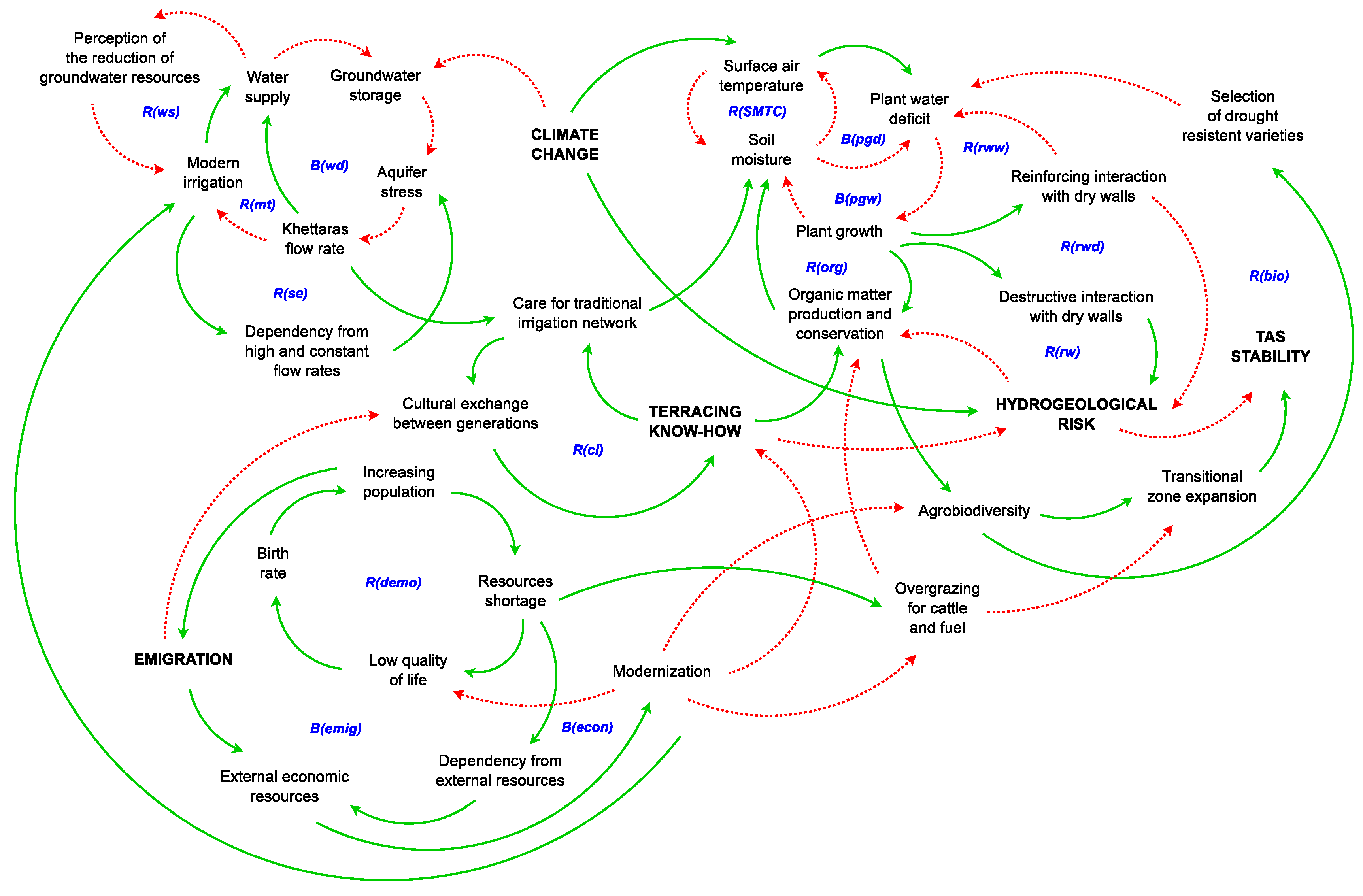
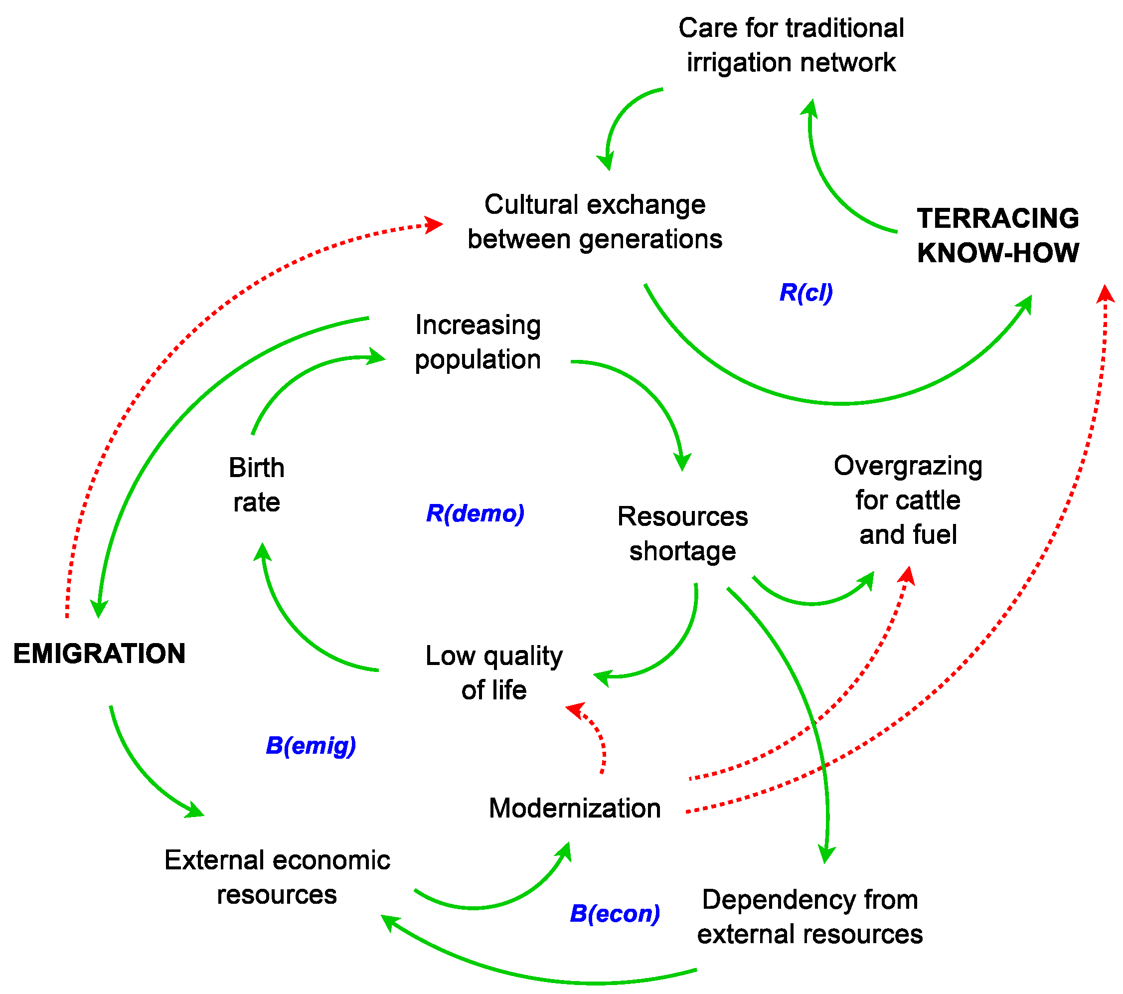
| Water supply | R(ws): | Modern irrigation increases water withdrawal capability and flexibility, increasing Water supply that can mislead the Perception of the reduction of groundwater resources and thus, encouraging a shift towards Modern irrigation to increase groundwater exploitation. |
| Water demand | B(wd) | An Aquifer stress can reduce the Khettaras flow rate which governs Water supply; a reduction in Water supply can increase Groundwater storage, easing the Aquifer stress, increasing Khettaras flow rate. |
| Traditional irrigation drift | R(mt) | Khettaras flow rate decreases, encouraging a drift towards Modern irrigation systems which increases Water supply, thus, reducing Groundwater storage, which cause the increase of Aquifer stress, reducing the Khettaras flow rate. |
| Supply effect | R(se) | Modern irrigation generally creates Dependency from high and constant flow rates increasing Aquifer stress, which by reducing even more the Khettaras flow rate increases dependency from Modern irrigation. |
| Demographic loop | R(demo) | Increasing population leads to a Resources shortage, which implies a Low quality of life, leading to a Birth rate increase. |
| Emigration loop | B(emig) | Emigration leads to an increase of emigrants sending money back to their families increasing External economic resources used to start a Modernization process inside the village, improving the Low quality of life. Higher quality of life reduces the Birth rate, reducing the Increasing population. |
| Economic dependency loop | B(econ) | External economic resources initiates a Modernization process inside the village improving the Low quality of life. Higher quality of life reduces the Birth rate, reducing the Increasing population, thus, reducing the Resources shortage and accordingly the Dependency from External economic resources. |
| Cultural landscape loop | R(cl) | TERRACING KNOW-HOW leads to a better Care for traditional irrigation network allowing a creation for a cultural landscape, that facilitates a Cultural exchange between generations. |
| Soil moisture and temp. | R(SMTC) | An increase in Soil moisture implies a decrease in Surface air temperature and vice versa. |
| Plant growth—wet lim. | B(pgw) | Plant growth decreases Soil moisture, which increases Plant water deficit which limits Plant growth. |
| Plant growth—dry lim. | B(pgd) | Plant growth decreases Soil moisture, which decreases Surface air temperature which, by increasing potential evapotranspiration, increases Plant water deficit which limits Plant growth. |
| Roots reinf. walls—wet loop | R(rww) | Plant growth can present a Reinforcing interaction with dry walls by the consolidation effect exerted by roots; this interaction shades the wall from wind and solar radiation, and the compaction of the stones reduces water runoff; all these effects decrease Plant water deficit promoting Plant growth. |
| Roots reinf. walls—dry loop | R(rwd) | Plant growth can present a Reinforcing interaction with dry walls through the consolidation effect exerted by roots; this interaction decreases HYDROGEOLOGICAL RISK, which generally increases the organic matter flushout. An increase in Organic matter production and conservation promotes Soil moisture which reduces Plant water deficit promoting Plant growth. |
| Roots disrupting walls | B(rw) | Plant growth can present a Destructive interaction with dry walls by the consolidation effect exerted by roots, this interaction increases HYDROGEOLOGICAL RISK, which generally decreases the organic matter flushout. An increase in Organic matter production and conservation promotes Soil moisture which reduces Plant water deficit promoting Plant growth. |
| Drought adaptation | R(bio) | An increase in Agrobiodiversity favors the Selection of drought resistant varieties, which can lead to a reduction of Plant water deficit, thus, to a promotion of Plant growth, which implies an increase in Organic matter production and conservation necessary to develop a higher Agrobiodiversity. |
| Hydrogeological Class | Fracturing | Lithology | % |
|---|---|---|---|
| Land with deep karst circulation | Abundant | Micaschists and gneiss from Iguerda’s buttonhole | 35.6% |
| Hyporheic circulation in wadis and valleys | Uncommon | Plio-quaternary deposits, volcano-sedimentary complex | 27.3% |
| Impermeable or less permeable grounds | Absent | Adoudonian limestones, granites and orthogneiss | 37.1% |
| Year | Duration in Days | Last Day without Rain |
|---|---|---|
| 2005 | 55 | 5 May |
| 1992 | 44 | 29 Jan |
| 2007 | 42 | 7 Jul |
| 2019 | 40 | 22 Jul |
| 2002 | 39 | 4 Jul |
| 2017 | 38 | 25 Nov |
| Parameter | Value |
|---|---|
| Cumulated precipitation in wet season | 150 mm |
| Cumulated precipitation in dry season | 72 mm |
| Cumulated potential evapotranspiration in wet season | 84 mm |
| Cumulated potential evapotranspiration in dry season | 306 mm |
| Ratio cumulated P during wet season over yearly cumulated P | 67% |
| Ratio cumulated during dry season over yearly cumulated | 78% |
| Water surplus in wet season | 66 mm |
| Water deficit in dry season | −234 mm |
| Parameter | Value |
|---|---|
| Cultivated area (active terraces) | 0.474 km |
| Whole terraced area (active and abandoned terraces) | 1.184 km |
| Direct evaporation from bare soil in wet season | 65% |
| Direct evaporation from bare soil in dry season | 90% |
| Base flow plus runoff in wet season | 25% |
| Base flow plus runoff in dry season | 0 % |
| Domestic water need per inhabitant | 200 L/in |
| Number of equivalent inhabitants (animals and people) | 1500 in |
| Parameter | Absolute c. s. m | Absolute h. s. m |
|---|---|---|
| Volume of water available during wet season | 1.305 | 1.305 |
| Volume of water available during dry season | 0.626 | 0.626 |
| Volume of water needed in agriculture during wet season | 0.040 | 0.099 |
| Volume of water needed in agriculture during dry season | 0.145 | 0.362 |
| Water surplus in wet season | 1.265 | 1.206 |
| Water surplus in dry season | 0.481 | 0.264 |
| Domestic water supply for 1500 inhabitants, in wet season | 0.064 | 0.064 |
| Domestic water supply for 1500 inhabitants, in dry season | 0.046 | 0.046 |
| Ksour | Female Population | Male Population | Tot. Population | Number of Households |
|---|---|---|---|---|
| Assaragh & Lemdint | 390 (55.63%) | 311 (44.87%) | 701 | 146 |
| Iguerda | 147 (50.87%) | 142 (49.13%) | 289 | 48 |
| Timdghart | 179 (52.65%) | 161 (47.35%) | 340 | 64 |
© 2020 by the authors. Licensee MDPI, Basel, Switzerland. This article is an open access article distributed under the terms and conditions of the Creative Commons Attribution (CC BY) license (http://creativecommons.org/licenses/by/4.0/).
Share and Cite
Boselli, V.; Ouallali, A.; Briak, H.; Houssni, M.; Kassout, J.; El Ouahrani, A.; Michailidi, E.M. System Dynamics Applied to Terraced Agroecosystems: The Case Study of Assaragh (Anti-Atlas Mountains, Morocco). Water 2020, 12, 1693. https://doi.org/10.3390/w12061693
Boselli V, Ouallali A, Briak H, Houssni M, Kassout J, El Ouahrani A, Michailidi EM. System Dynamics Applied to Terraced Agroecosystems: The Case Study of Assaragh (Anti-Atlas Mountains, Morocco). Water. 2020; 12(6):1693. https://doi.org/10.3390/w12061693
Chicago/Turabian StyleBoselli, Vladimiro, Abdessalam Ouallali, Hamza Briak, Mhammad Houssni, Jalal Kassout, Abdeltif El Ouahrani, and Eleni Maria Michailidi. 2020. "System Dynamics Applied to Terraced Agroecosystems: The Case Study of Assaragh (Anti-Atlas Mountains, Morocco)" Water 12, no. 6: 1693. https://doi.org/10.3390/w12061693
APA StyleBoselli, V., Ouallali, A., Briak, H., Houssni, M., Kassout, J., El Ouahrani, A., & Michailidi, E. M. (2020). System Dynamics Applied to Terraced Agroecosystems: The Case Study of Assaragh (Anti-Atlas Mountains, Morocco). Water, 12(6), 1693. https://doi.org/10.3390/w12061693