
Rivers Try Harder. Reversed “Differential Erosion” as Geological Control of Flood in the Large Fluvial Systems in Poland


Abstract
:1. Introduction
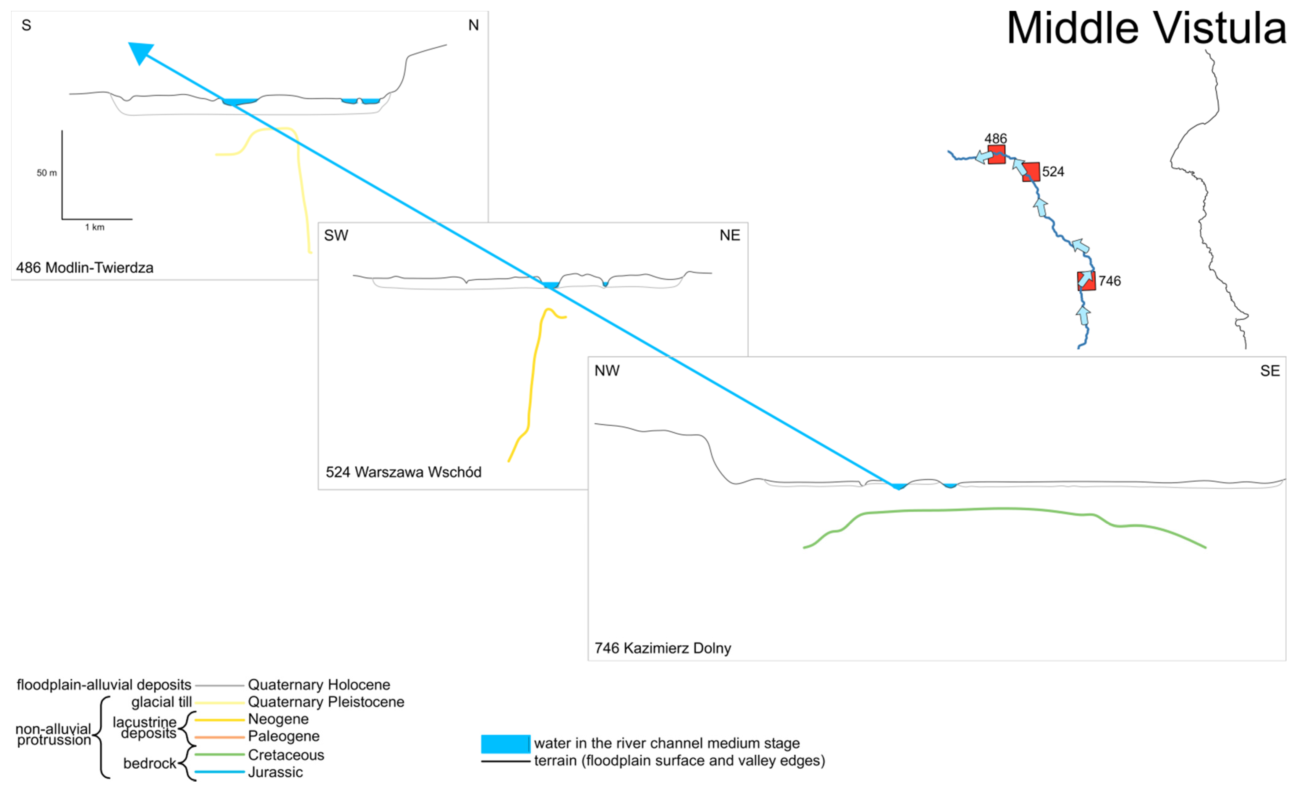
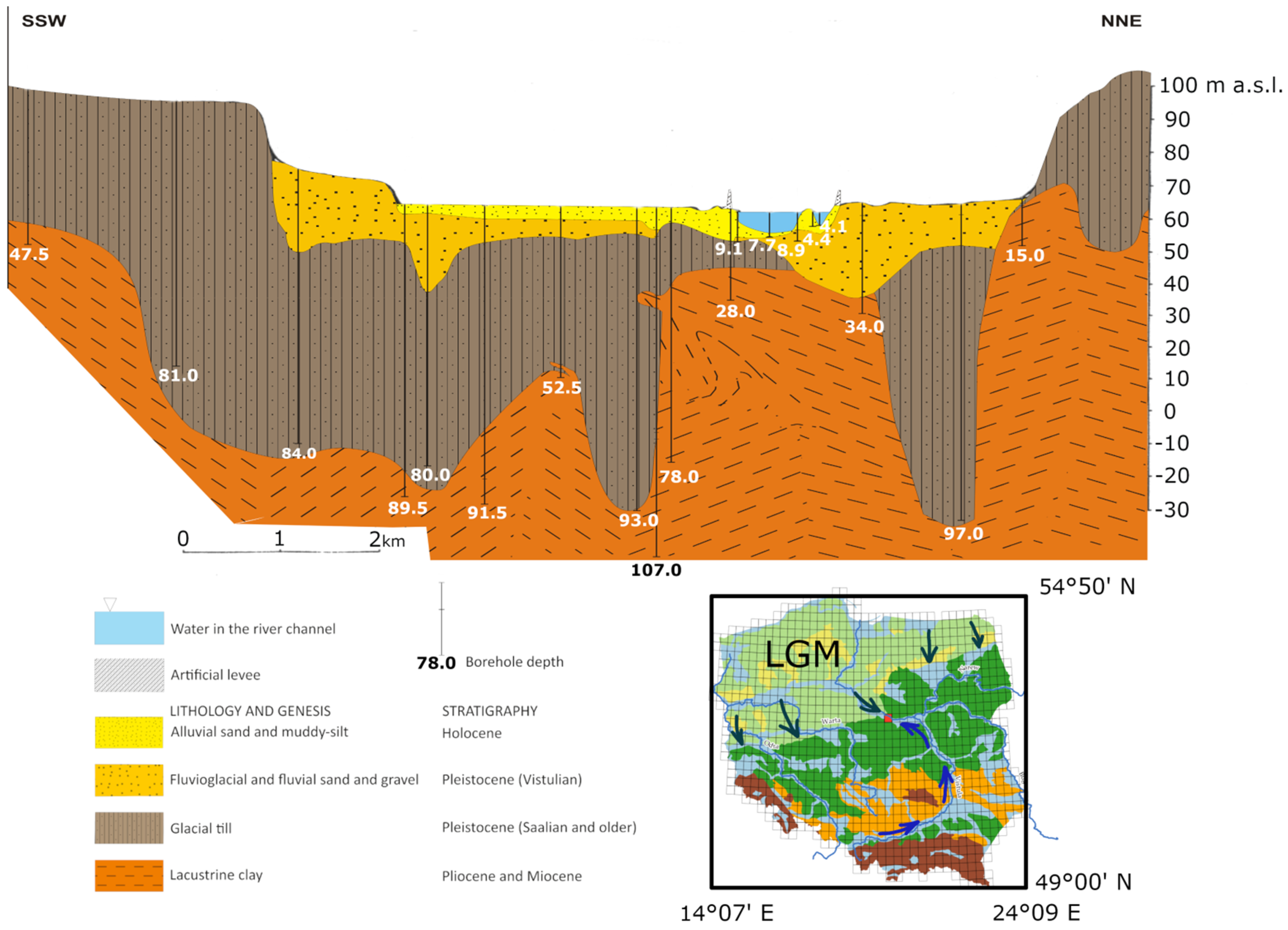
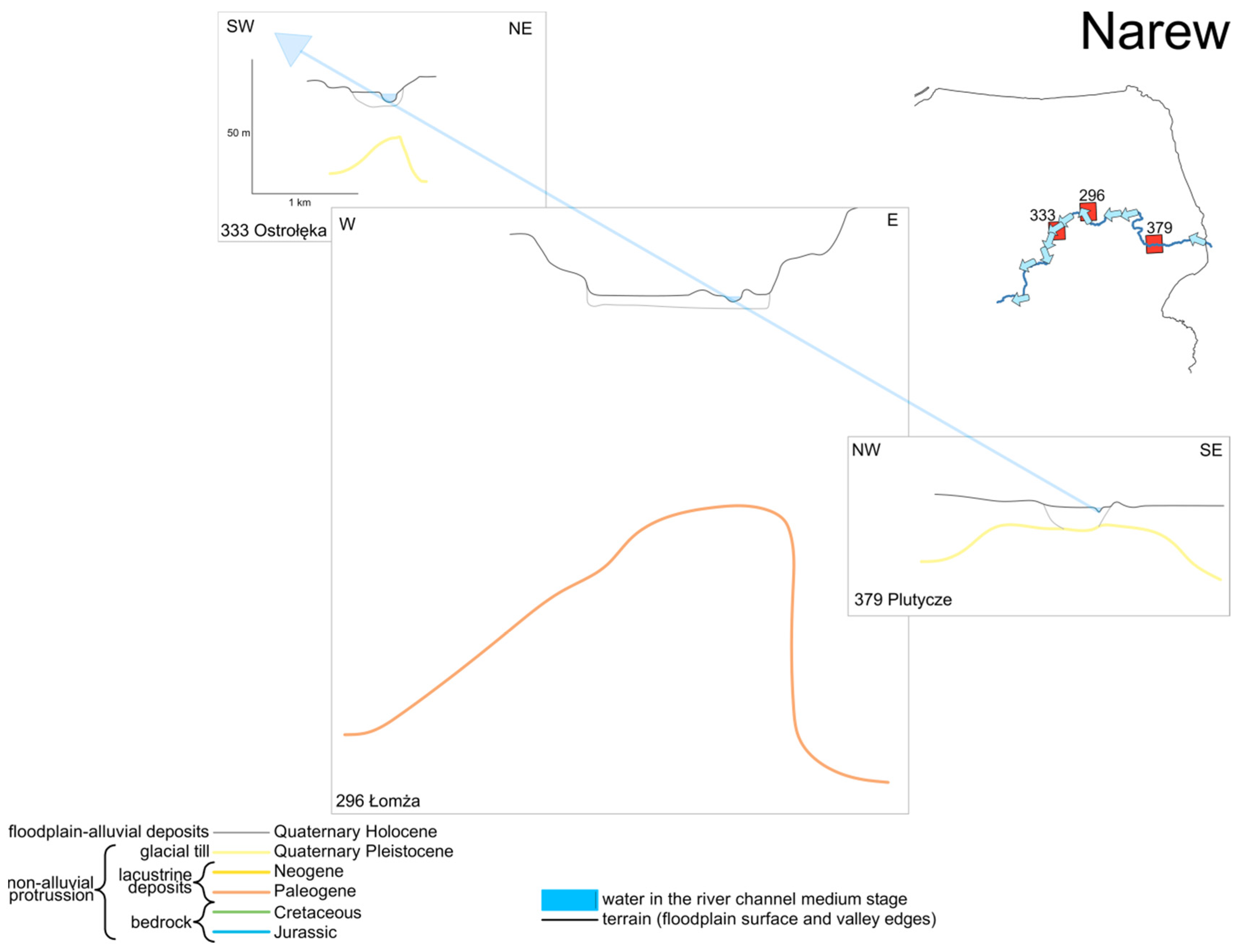
2. Study Area, Materials and Methods
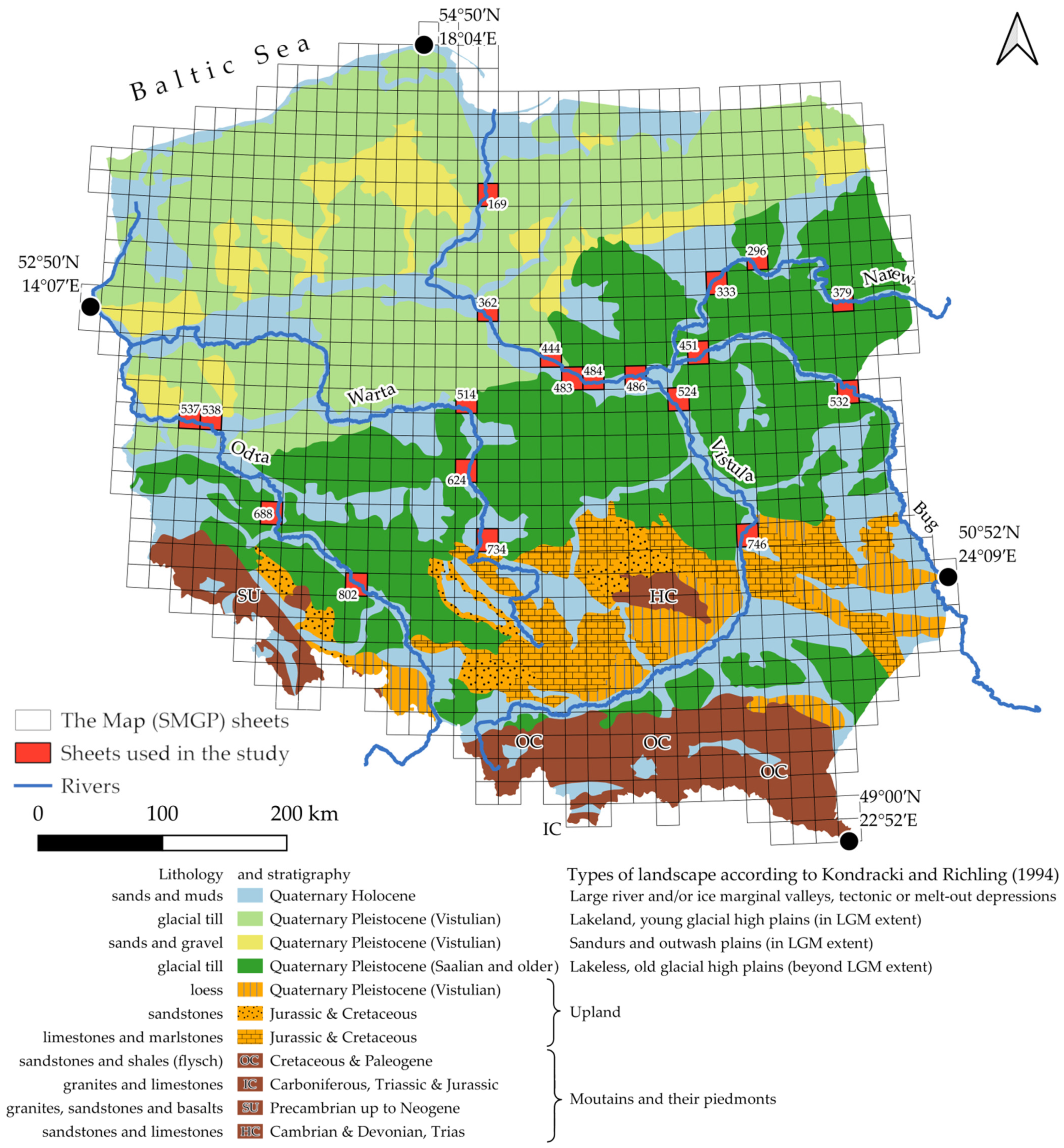
3. Results and Discussion

4. Conclusions
Author Contributions
Funding
Data Availability Statement
Acknowledgments
Conflicts of Interest
References
- Tockner, K.; Stanford, J.A. Riverine flood plains: Present state and future trends. Environ. Conserv. 2002, 29, 308–330. [Google Scholar] [CrossRef] [Green Version]
- Balogh, M.; Kiss, T.; Fiala, K.; Fehérváry, I. Floodplain forms along the lowland Maros River, Hungary. Geogr. Pol. 2020, 93, 51–68. [Google Scholar] [CrossRef]
- Izumida, A.; Uchiyama, S.; Sugai, T. Application of UAV-SfM photogrammetry and aerial lidar to a disastrous flood: Repeated topographic measurement of a newly formed crevasse splay of the Kinu River, central Japan. Nat. Hazards Earth Syst. Sci. 2017, 17, 1505–1519. [Google Scholar] [CrossRef] [Green Version]
- Gouw, M.J.P.; Autin, W.J. Alluvial architecture of the Holocene Lower Mississippi Valley (U.S.A.) and a comparison with the Rhine–Meuse delta (The Netherlands). Sediment. Geol. 2008, 204, 106–121. [Google Scholar] [CrossRef]
- Lóczy, D.; Pirkhoffer, E.; Gyenizse, P. Geomorphometric floodplain classification in a hill region of Hungary. Geomorphology 2012, 147–148, 61–72. [Google Scholar] [CrossRef]
- Macklin, M.G.; Benito, G.; Gregory, K.J.; Johnstone, E.; Lewin, J.; Michczyńska, D.J.; Soja, R.; Starkel, L.; Thorndycraft, V.R. Past hydrological events reflected in the Holocene fluvial record of Europe. CATENA 2006, 66, 145–154. [Google Scholar] [CrossRef]
- Lombardi, R.; Davis, L.; Stinchcomb, G.E.; Munoz, S.E.; Stewart, L.; Therrell, M.D. Fluvial activity in major river basins of the eastern United States during the Holocene. Holocene 2020, 30, 1279–1295. [Google Scholar] [CrossRef]
- Price, S.J.; Ford, J.R.; Cooper, A.H.; Neal, C. Humans as major geological and geomorphological agents in the Anthropocene: The significance of artificial ground in Great Britain. Philos. Trans. R. Soc. A Math. Phys. Eng. Sci. 2011, 369, 1056–1084. [Google Scholar] [CrossRef] [PubMed]
- Brown, A.G.; Tooth, S.; Bullard, J.E.; Thomas, D.S.G.; Chiverrell, R.C.; Plater, A.J.; Murton, J.; Thorndycraft, V.R.; Tarolli, P.; Rose, J.; et al. The geomorphology of the Anthropocene: Emergence, status and implications. Earth Surf. Process. Landf. 2017, 42, 71–90. [Google Scholar] [CrossRef] [Green Version]
- Nikolov, T.; Hristova, R. Anthropocene versus Holocene in the Light of the Principles of Stratigraph. C. R. Acad. Bulg. Sci. 2020, 73, 236–243. [Google Scholar] [CrossRef]
- Falkowski, T.; Ostrowski, P.; Siwicki, P.; Brach, M. Channel morphology changes and their relationship to valley bottom geology and human interventions; a case study from the Vistula Valley in Warsaw, Poland. Geomorphology 2017, 297, 100–111. [Google Scholar] [CrossRef]
- Falkowski, T.; Ostrowski, P.; Bogucki, M.; Karczmarz, D. The trends in the main thalweg path of selected reaches of the Middle Vistula River, and their relationships to the geological structure of river channel zone. Open Geosci. 2018, 10, 554–564. [Google Scholar] [CrossRef]
- Wierzbicki, G.; Ostrowski, P.; Falkowski, T.; Mazgajski, M. Geological setting control of flood dynamics in lowland rivers (Poland). Sci. Total Environ. 2018, 636, 367–382. [Google Scholar] [CrossRef]
- Bujakowski, F.; Falkowski, T. Hydrogeological Analysis Supported by Remote Sensing Methods as A Tool for Assessing the Safety of Embankments (Case Study from Vistula River Valley, Poland). Water 2019, 11, 266. [Google Scholar] [CrossRef] [Green Version]
- Ostrowski, P.; Falkowski, T. Application of Remote Sensing Methods to Study the Relief of Lowland River Valleys with a Complex Geological Structure—A Case Study of the Bug River. Water 2020, 12, 487. [Google Scholar] [CrossRef] [Green Version]
- Falkowski, T. Alluvial bottom geology inferred as a factor controlling channel flow along the Middle Vistula River, Poland. Geol. Q. 2007, 51, 91–102. [Google Scholar]
- Falkowski, T. The application of geomorphological analysis of the Vistula River, Poland in the evaluation of the safety regulation structures. Acta Geol. Pol. 2007, 57, 377–390. [Google Scholar]
- Weckwerth, P. Fluvial responses to the Weichselian ice sheet advances and retreats: Implications for understanding river paleohydrology and pattern changes in Central Poland. Int. J. Earth Sci. 2018, 107, 1407–1429. [Google Scholar] [CrossRef] [Green Version]
- Goudie, A. Alphabetical glossary of geomorphology, version 1. Electron. Ed. Int. Assoc. Geomorphol. 2014, 2014, 84. [Google Scholar]
- Yunus, A.P. Geomorphic and lithologic control on bedrock channels in drainage basins of the Western Arabian Peninsula. Arab. J. Geosci. 2016, 9, 133. [Google Scholar] [CrossRef]
- Migoń, P.; Jancewicz, K.; Różycka, M.; Duszyński, F.; Kasprzak, M. Large-scale slope remodelling by landslides—Geomorphic diversity and geological controls, Kamienne Mts., Central Europe. Geomorphology 2017, 289, 134–151. [Google Scholar] [CrossRef]
- Carlson, B.M.; Schermer, E.R.; Amos, C.B.; Stephenson, W.J.; Sherrod, B.L.; Mahan, S.A. Holocene fault reactivation in the eastern cascades, Washington. Bull. Seismol. Soc. Am. 2018, 108, 2614–2633. [Google Scholar] [CrossRef]
- Glaus, G.; Delunel, R.; Stutenbecker, L.; Akçar, N.; Christl, M.; Schlunegger, F. Differential erosion and sediment fluxes in the Landquart basin and possible relationships to lithology and tectonic controls. Swiss J. Geosci. 2019, 112, 453–473. [Google Scholar] [CrossRef]
- Ngapna, M.N.; Owona, S.; Owono, F.M.; Ateba, C.B.; Tsimi, V.M.; Ondoa, J.M.; Ekodeck, G.E. Assessment of relative active tectonics in Edea–Eseka region (SW Cameroon, Central Africa). J. Afr. Earth Sci. 2020, 164. [Google Scholar] [CrossRef]
- Gaidzik, K.; Herrera, R.M.T. Geomorphic indices and relative tectonic uplift in the Guerrero sector of the Mexican forearc. Geosci. Front. 2017, 8, 885–902. [Google Scholar] [CrossRef] [Green Version]
- Starkel, L. The age of the stages of development of the relief of the Polish Carpathians in the light of the most recent geological investigations. Stud. Geomorphol. Carpath. Balc. 1969, 3, 33–44. [Google Scholar]
- Zuchiewicz, W. Planation surfaces in the Polish Carpatians: Myth or reality? Geogr. Pol. 2011, 84, 155–178. [Google Scholar] [CrossRef] [Green Version]
- Andreucci, B.; Castelluccio, A.; Jankowski, L.; Mazzoli, S.; Szaniawski, R.; Zattin, M. Burial and exhumation history of the Polish Outer Carpathians: Discriminating the role of thrusting and post-thrusting extension. Tectonophysics 2013, 608, 866–883. [Google Scholar] [CrossRef]
- Wierzbicki, G.; Ostrowski, P.; Falkowski, T. Applying floodplain geomorphology to flood management (The Lower Vistula River upstream from Plock, Poland). Open Geosci. 2020, 12, 1003–1016. [Google Scholar] [CrossRef]
- Wierzbicki, G.; Ostrowski, P.; Bartold, P.; Bujakowski, F.; Falkowski, T.; Osiński, P. Urban geomorphology of the Vistula River valley in Warsaw. J. Maps 2021, 1–16. [Google Scholar] [CrossRef]
- Stroeven, A.P.; Hättestrand, C.; Kleman, J.; Heyman, J.; Fabel, D.; Fredin, O.; Goodfellow, B.W.; Harbor, J.M.; Jansen, J.D.; Olsen, L.; et al. Deglaciation of Fennoscandia. Quat. Sci. Rev. 2016, 147, 91–121. [Google Scholar] [CrossRef] [Green Version]
- Patton, H.; Hubbard, A.; Andreassen, K.; Auriac, A.; Whitehouse, P.L.; Stroeven, A.P.; Shackleton, C.; Winsborrow, M.; Heyman, J.; Hall, A.M. Deglaciation of the Eurasian ice sheet complex. Quat. Sci. Rev. 2017, 169, 148–172. [Google Scholar] [CrossRef] [Green Version]
- Dyke, A.S.; Andrews, J.T.; Clark, P.U.; England, J.H.; Miller, G.H.; Shaw, J.; Veillette, J.J. The Laurentide and Innuitian ice sheets during the Last Glacial Maximum. Quat. Sci. Rev. 2002, 21, 9–31. [Google Scholar] [CrossRef]
- Marshall, S.J.; James, T.S.; Clarke, G.K.C. North American Ice Sheet reconstructions at the Last Glacial Maximum. Quat. Sci. Rev. 2002, 21, 175–192. [Google Scholar] [CrossRef]
- Ber, A. The detailed geological map of Poland 1:50,000: The history, present and future. Prz. Geol. 2005, 53, 903–906. [Google Scholar]
- Sawicki, L. Terminologja Regjonalna ziem Polskich, Uchwalona i Polecona Przez Zjazd Geograficzny, Zorganizowany Staraniem Tow. Naucz. Szk. Wyż. w Krakowie 1922; Nakładem Księgarni Geograficznej Orbis: Warsaw, Poland, 1922. [Google Scholar]
- Miller, B.A.; Juilleret, J. The colluvium and alluvium problem: Historical review and current state of definitions. Earth Sci. Rev. 2020, 209. [Google Scholar] [CrossRef]
- Hjulström, F. Studies of the Morphological Activity of Rivers as Illustrated by the River Fyris. Geogr. Ann. 1936, 18, 121–123. [Google Scholar] [CrossRef]
- Worrall, F.; Burt, T.P.; Hancock, G.R.; Howden, N.J.K.; Wainwright, J. The problem of underpowered rivers. Earth Surf. Process. Landf. 2020, 45, 3869–3878. [Google Scholar] [CrossRef]
- Bąkowska, A.; Dobak, D.; Gawriuczenkow, I.; Kiełbasiński, K.; Szczepański, T.; Trzciński, J.; Wójcik, E.; Zawrzykraj, P. Stress-strain behaviour analysis of Middle Polish glacial tills from Warsaw (Poland) based on the interpretation of advanced field and laboratory tests. Acta Geol. Pol. 2016, 66, 562–586. [Google Scholar] [CrossRef] [Green Version]
- Dobak, P.; Kiełbasiński, K.; Szczepański, T.; Zawrzykraj, P. Verification of compressibility and consolidation parameters of varved clays from Radzymin (Central Poland) based on direct observations of settlements of road embankment. Open Geosci. 2018, 10, 911–924. [Google Scholar] [CrossRef]
- Rabarijoely, S. Rigidity of “Warsaw clay” from the Poznań Formation determined by in situ tests. Open Geosci. 2020, 12, 1274–1285. [Google Scholar] [CrossRef]
- Cohen, K.M.; Finney, S.C.; Gibbard, P.L.; Fan, J.X. The ICS International Chronostratigraphic Chart. Episodes 2013, 36, 199–204. [Google Scholar] [CrossRef] [PubMed]
- QGIS Development Team. QGIS 3.10 LTR Geographic Information System. Open Source Geospatial Foundation Projects. 2019. Available online: http://qgis.osgeo.org/ (accessed on 1 February 2021).
- Inkscape Project, Inkscape. 2020. Available online: https://inkscape.org (accessed on 1 February 2021).
- Kondracki, J.; Richling, A. Regiony fizycznogeograficzne [in:] Atlas Rzeczpospolitej Polskiej; Główny Geodeta Kraju: Warsaw, Poland, 1994.
- CBS i PBW Hydroprojekt. Kaskada Dolnej Wisły. Koncepcja 1957 [The Lower Vistula Cascade. The 1957 Concept]; CBS i PBW Hydroprojekt: Warsaw, Poland, 1957. [Google Scholar]
- Szydlowski, M.; Szymkiewicz, R.; Gasiorowski, D.; Hakiel, J.; Zima, P. Hydraulic potential of the Lower Vistula (Poland). E3S Web Conf. 2018, 40, 3011. [Google Scholar] [CrossRef] [Green Version]
- Kucharska, M.; Szwarc, P.K. Detailed Geological Map of Poland 1:50 000; Sheet 451 Wyszków; The Polish Geological Institute—National Research Institute: Warsaw, Poland, 2012. Available online: http://bazadata.pgi.gov.pl/data/smgp/arkusze_skany/smgp0451.jpg (accessed on 1 February 2021).
- Nitrychoruk, J.; Dzierżek, J.; Stańczuk, D. Detailed Geological Map of Poland 1:50 000; Sheet 532 Janów Podlaski; The Polish Geological Institute: Warsaw, Poland, 2003. Available online: http://bazadata.pgi.gov.pl/data/smgp/arkusze_skany/smgp0532.jpg (accessed on 1 February 2021).
- Solon, J.; Borzyszkowski, J.; Bidłasik, M.; Richling, A.; Badora, K.; Balon, J.; Wójcik, B.T.; Chabudziński, Ł.; Dobrowolski, R.; Grzegorczyk, I.; et al. Physico-geographical mesoregions of Poland: Verification and adjustment of boundaries on the basis of contemporary spatial data. Geogr. Pol. 2018, 91, 143–170. [Google Scholar] [CrossRef]
- Bałuk, A.; Petelski, K. Detailed Geological Map of Poland 1:50 000; Sheet 296 Łomża; The Polish Geological Institute—National Research Institute: Warsaw, Poland, 2009. Available online: http://bazadata.pgi.gov.pl/data/smgp/arkusze_skany/smgp0296.jpg (accessed on 1 February 2021).
- Bałuk, A. Description to Detailed Geological Map of Poland 1:50 000; Sheet 333 Ostrołęka; The Polish Geological Institute: Warsaw, Poland, 1993. Available online: http://bazadata.pgi.gov.pl/data/smgp/arkusze_txt/smgp0333.pdf (accessed on 1 February 2021).
- Kmieciak, M. Detailed Geological Map of Poland 1:50 000; Sheet 379 Plutycze; The Polish Geological Institute: Warsaw, Poland, 2003. Available online: http://bazadata.pgi.gov.pl/data/smgp/arkusze_skany/smgp0379.jpg (accessed on 1 February 2021).
- Chachaj, J. Detailed Geological Map of Poland 1:50 000; Sheet 537 Czerwieńsk; The Polish Geological Institute: Warsaw, Poland, 2000. Available online: http://bazadata.pgi.gov.pl/data/smgp/arkusze_skany/smgp0537.jpg (accessed on 1 February 2021).
- Nowak, J. Detailed Geological Map of Poland 1:50 000; Sheet 538 Sulechów; The Polish Geological Institute: Warsaw, Poland, 2000. Available online: http://bazadata.pgi.gov.pl/data/smgp/arkusze_skany/smgp0538.jpg (accessed on 1 February 2021).
- Michalska, E. Detailed Geological Map of Poland 1:50 000; Sheet 688 Ścinawa; The Geological Institute, Poland: Warsaw, Poland, 1979. Available online: http://bazadata.pgi.gov.pl/data/smgp/arkusze_skany/smgp0688.jpg (accessed on 1 February 2021).
- Michalska, E. Detailed Geological Map of Poland 1:50 000; Sheet 802 Oława; The Polish Geological Institute: Warsaw, Poland, 1992. Available online: http://bazadata.pgi.gov.pl/data/smgp/arkusze_skany/smgp0802.jpg (accessed on 1 February 2021).
- Szałamacha, G. Detailed Geological Map of Poland 1:50 000; Sheet 514 Koło; The Polish Geological Institute—National Research Institute: Warsaw, Poland, 1997. Available online: http://bazadata.pgi.gov.pl/data/smgp/arkusze_skany/smgp0514.jpg (accessed on 1 February 2021).
- Klatkowa, H.; Załoba, M. Detailed Geological Map of Poland 1:50 000; Sheet 624 Warta; The Polish Geological Institute: Warsaw, Poland, 1990. Available online: http://bazadata.pgi.gov.pl/data/smgp/arkusze_skany/smgp0624.jpg (accessed on 1 February 2021).
- Ziomek, J.; Gałązka, D. Detailed Geological Map of Poland 1:50 000; Sheet 734 Osjaków; The Polish Geological Institute—National Research Institute: Warsaw, Poland, 2013. Available online: http://bazadata.pgi.gov.pl/data/smgp/arkusze_skany/smgp0734.jpg (accessed on 1 February 2021).
- Kozłowska, M.; Kozłowski, I. Detailed Geological Map of Poland 1:50 000; Sheet 169 Kwidzyn; The Geological Institute: Warsaw, Poland, 1981. Available online: http://bazadata.pgi.gov.pl/data/smgp/arkusze_skany/smgp0169.jpg (accessed on 1 February 2021).
- Łyczewska, J. Detailed Geological Map of Poland 1:50 000; Sheet 362 Ciechocinek; The Geological Institute, Poland: Warsaw, Poland, 1973. Available online: http://bazadata.pgi.gov.pl/data/smgp/arkusze_skany/smgp0362.jpg (accessed on 1 February 2021).
- Skompski, S.; Słowiański, W. Detailed Geological Map of Poland 1:50 000; Sheet 444 Płock; The Geological Institute: Warsaw, Poland, 1962. Available online: http://bazadata.pgi.gov.pl/data/smgp/arkusze_skany/smgp0444.jpg (accessed on 1 February 2021).
- Makowska, A.; Skompski, S. Detailed Geological Map of Poland 1:50 000; Sheet 483 Słubice; The Geological Institute: Warsaw, Poland, 1962. Available online: http://bazadata.pgi.gov.pl/data/smgp/arkusze_skany/smgp0483.jpg (accessed on 1 February 2021).
- Makowska, A.; Ruszczyńska, H.; Kucharska, M.; Wasiluk, R. Detailed Geological Map of Poland 1:50 000; Sheet 484 Wyszogród; The Polish Geological Institute—National Research Institute: Warsaw, Poland, 2005. Available online: http://bazadata.pgi.gov.pl/data/smgp/arkusze_skany/smgp0484.jpg (accessed on 1 February 2021).
- Nowak, J.; Skompski, S. Detailed Geological Map of Poland 1:50 000; Sheet 486 Modlin-Twierdza; The Polish Geological Institute: Warsaw, Poland, 1992. Available online: http://bazadata.pgi.gov.pl/data/smgp/arkusze_skany/smgp0486.jpg (accessed on 1 February 2021).
- Sarnacka, Z. Detailed Geological Map of Poland 1:50 000; Sheet 524 Warszawa Wschód; The Geological Institute: Warsaw, Poland, 1979. Available online: http://bazadata.pgi.gov.pl/data/smgp/arkusze_skany/smgp0524.jpg (accessed on 1 February 2021).
- Dowgiałło, W.D. Detailed Geological Map of Poland 1:50 000; Sheet 746 Kazimierz Dolny; The Geological Institute: Warsaw, Poland, 1981. Available online: http://bazadata.pgi.gov.pl/data/smgp/arkusze_skany/smgp0746.jpg (accessed on 1 February 2021).
- Wierzbicki, G.; Grygoruk, M.; Grodzka-Łukaszewska, M.; Bartold, P.; Okruszko, T. Mire Development and Disappearance due to River Capture as Hydrogeological and Geomorphological Consequences of LGM Ice-Marginal Valley Evolution at the Vistula-Neman Watershed. Geosciences 2020, 10, 363. [Google Scholar] [CrossRef]
- Hauer, C.; Pulg, U. The non-fluvial nature of Western Norwegian rivers and the implications for channel patterns and sediment composition. CATENA 2018, 171, 83–98. [Google Scholar] [CrossRef]
- Hauer, C.; Pulg, U. Buried and forgotten—The non-fluvial characteristics of postglacial rivers. River Res. Appl. 2020, rra.3596. [Google Scholar] [CrossRef] [Green Version]
- Geiger, H. Instream River Training-Stream Design in Oehringen according to Viktor Schauberger’s Principles. Wasserwirtschaft 2013, 103, 47–48. [Google Scholar] [CrossRef]
- Werdenberg, N.; Mende, M.; Sindelar, C. Instream river training: Fundamentals and practical example. In River Flow 2014; CRC Press: Boca Raton, FL, USA, 2014; pp. 1571–1577. [Google Scholar]
- Bagnold, R.A. An Approach to the Sediment Transport Problem from General Physics; US Government Printing Office: Washington, DC, USA, 1966.
- Vayssière, A.; Castanet, C.; Gautier, E.; Virmoux, C.; Dépret, T.; Gandouin, E.; Develle, A.L.; Mokadem, F.; Copard, S.S.; Sabatier, P.; et al. Readjustments of a sinuous river during the last 6000 years in northwestern Europe (Cher River, France): From an active meandering river to a stable river course under human forcing. Geomorphology 2020, 370, 7395. [Google Scholar] [CrossRef]
- Venditti, J.G.; Li, T.; Deal, E.; Dingle, E.; Church, M. Struggles with stream power: Connecting theory across scales. Geomorphology 2020, 366, 6817. [Google Scholar] [CrossRef]
- Bull, W.B. Threshold of critical power in streams. Geol. Soc. Am. Bull. 1979, 90, 453–464. [Google Scholar] [CrossRef]
- Nanson, G.C.; Croke, J.C. A genetic classification of floodplains. Geomorphology 1992, 4, 459–486. [Google Scholar] [CrossRef] [Green Version]
- Wierzbicki, G.; Ostrowski, P.; Mazgajski, M.; Bujakowski, F. Using VHR multispectral remote sensing and LIDAR data to determine the geomorphological effects of overbank flow on a floodplain (the Vistula River, Poland). Geomorphology 2013, 183, 73–81. [Google Scholar] [CrossRef]
- Betz, F.; Lauermann, M.; Cyffka, B. Open Source Riverscapes: Analyzing the Corridor of the Naryn River in Kyrgyzstan Based on Open Access Data. Remote Sens. 2020, 12, 2533. [Google Scholar] [CrossRef]
- Hrabia, B.A.; Strugała, K.M.; Bryndal, T.; Cebulski, J.; Kiszka, K.; Kroczak, R. An integrated approach for investigating geomorphic changes due to flash flooding in two small stream channels (Western Polish Carpathians). J. Hydrol. Reg. Stud. 2020, 31, 731. [Google Scholar] [CrossRef]
- Candel, J.; Kleinhans, M.; Makaske, B.; Wallinga, J. Predicting river channel pattern based on stream power, bed material and bank strength. Prog. Phys. Geogr. Earth Environ. 2020. [Google Scholar] [CrossRef]
- Gu, Z.; Fan, H.; Yang, K. GIS and DEM based analysis of incision and drainage reorganization of the Buyuan River basin in the upper Lancang-Mekong of China since the Late Pleistocene. J. Geogr. Sci. 2020, 30, 1495–1506. [Google Scholar] [CrossRef]
- Tranmer, A.W.; Caamaño, D.; Goodwin, P. Identifying dynamic equilibrium of an undeveloped alluvial stream by extremal hypotheses. CATENA 2020, 194, 4680. [Google Scholar] [CrossRef]
- Tullis, B.; Bradshaw, R. Impact Dissipators; Chanson, H., Ed.; CRC press: Boca Raton, FL, USA, 2015; pp. 131–157. [Google Scholar]
- Roman, M. Ice-flow directions of the last Scandinavian Ice Sheet in central Poland. Quat. Int. 2019, 501, 4–20. [Google Scholar] [CrossRef]
- Brykczyński, M. Valley-side glaciotectonics in the Warsaw Basin and Płock Basin. Pr. Muz. Ziemi 1982, 35, 3–68. [Google Scholar]
- Narloch, W.; Phillips, E.R.; Piotrowski, J.A.; Ćwiek, M. Patterns of deformation within a subglacial shear zone: Implications for palaeo-ice stream bed evolution. Sediment. Geol. 2020, 397, 5569. [Google Scholar] [CrossRef]
- Vestøl, O.; Ågren, J.; Steffen, H.; Kierulf, H.; Tarasov, L. NKG2016LU: A new land uplift model for Fennoscandia and the Baltic Region. J. Geod. 2019, 93, 1759–1779. [Google Scholar] [CrossRef] [Green Version]
- Skompski, S. Stratygrafia osadów czwartorzędowych wschodniej części Kotliny Płockiej. Biul. Inst. Geol. 1969, 220, 175–258. [Google Scholar]
- Wierzbicki, G. Geological Setting Controls on a Floodplain Morphodynamics in the Vistula River Valley near Kępa Polska. Ph.D. Thesis, Warsaw University of Life Sciences SGGW-WULS, Warszawa, Poland, 2015. [Google Scholar]
- Wysota, W.; Molewski, P.; Sokołowski, R.J. Record of the Vistula ice lobe advances in the Late Weichselian glacial sequence in north-central Poland. Quat. Int. 2009, 207, 26–41. [Google Scholar] [CrossRef]
- Fuller, I.C.; Gilvear, D.J.; Thoms, M.C.; Death, R.G. Framing resilience for river geomorphology: Reinventing the wheel? River Res. Appl. 2019, 35, 91–106. [Google Scholar] [CrossRef]
- Coltorti, M.; Dramis, F.; Ollier, C.D. Planation surfaces in Northern Ethiopia. Geomorphology 2007, 89, 287–296. [Google Scholar] [CrossRef]


Publisher’s Note: MDPI stays neutral with regard to jurisdictional claims in published maps and institutional affiliations. |
© 2021 by the authors. Licensee MDPI, Basel, Switzerland. This article is an open access article distributed under the terms and conditions of the Creative Commons Attribution (CC BY) license (http://creativecommons.org/licenses/by/4.0/).
Share and Cite
Bihałowicz, J.S.; Wierzbicki, G. Rivers Try Harder. Reversed “Differential Erosion” as Geological Control of Flood in the Large Fluvial Systems in Poland. Water 2021, 13, 424. https://doi.org/10.3390/w13040424
Bihałowicz JS, Wierzbicki G. Rivers Try Harder. Reversed “Differential Erosion” as Geological Control of Flood in the Large Fluvial Systems in Poland. Water. 2021; 13(4):424. https://doi.org/10.3390/w13040424
Chicago/Turabian StyleBihałowicz, Jan Stefan, and Grzegorz Wierzbicki. 2021. "Rivers Try Harder. Reversed “Differential Erosion” as Geological Control of Flood in the Large Fluvial Systems in Poland" Water 13, no. 4: 424. https://doi.org/10.3390/w13040424
APA StyleBihałowicz, J. S., & Wierzbicki, G. (2021). Rivers Try Harder. Reversed “Differential Erosion” as Geological Control of Flood in the Large Fluvial Systems in Poland. Water, 13(4), 424. https://doi.org/10.3390/w13040424