
The Catastrophe of the Niedów Dam—The Causes of the Dam’s Breach, Its Development, and Consequences


Abstract
1. Introduction
2. Case Study
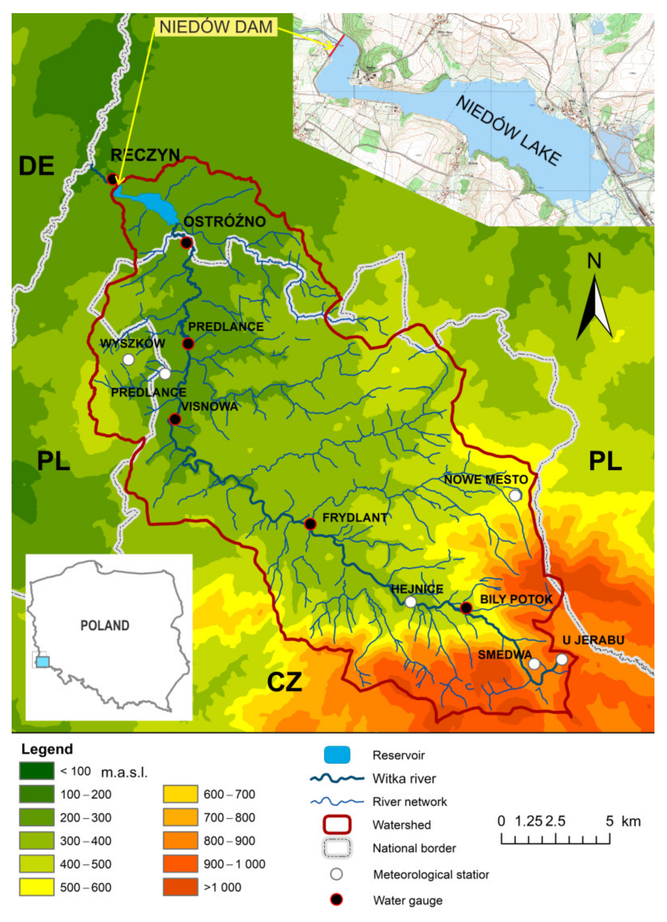
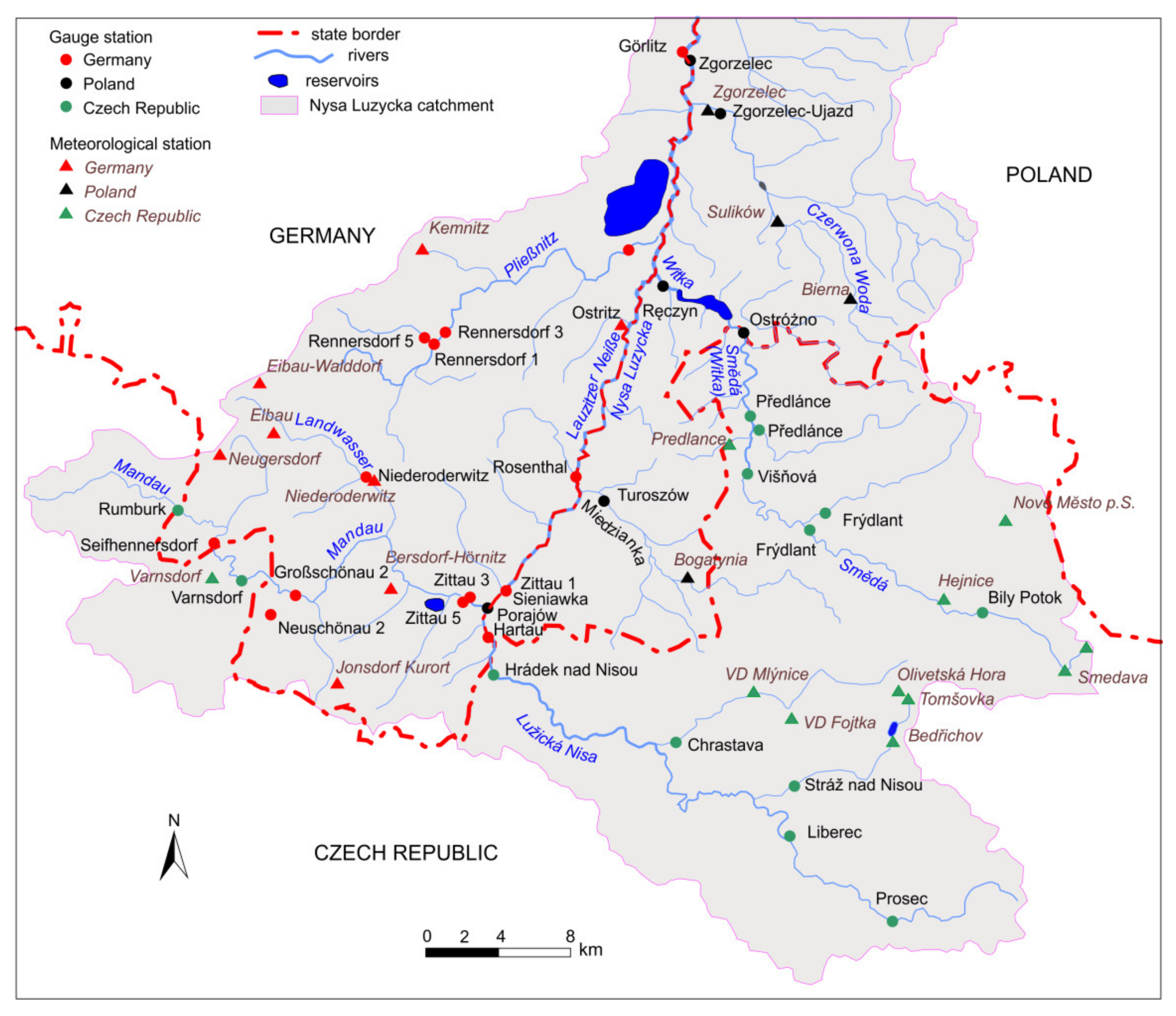
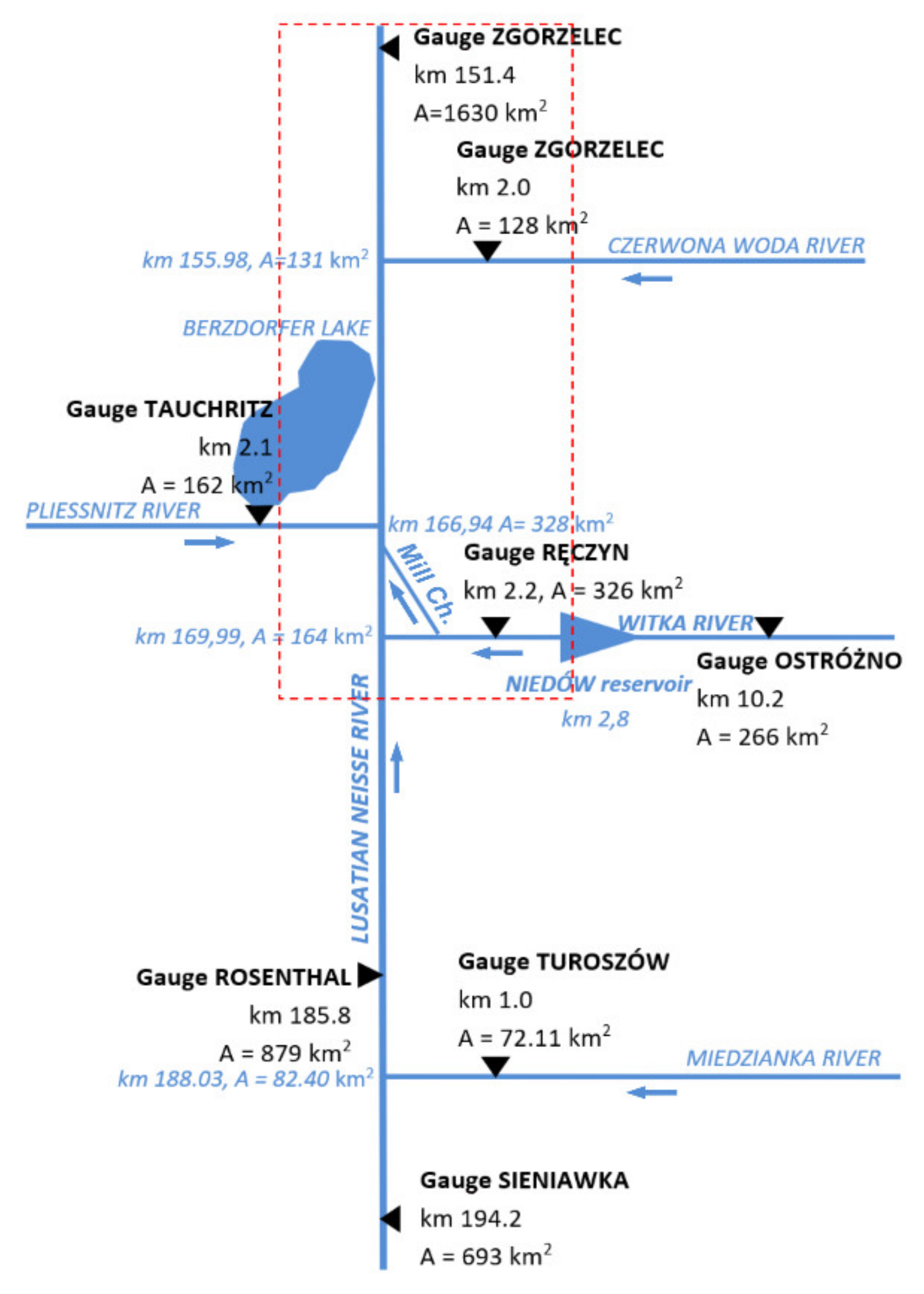
2.1. Description of the Study Area
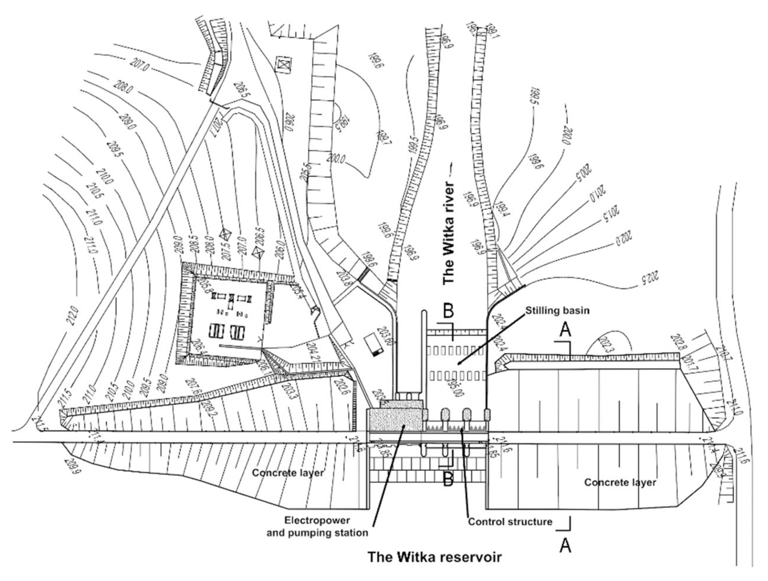
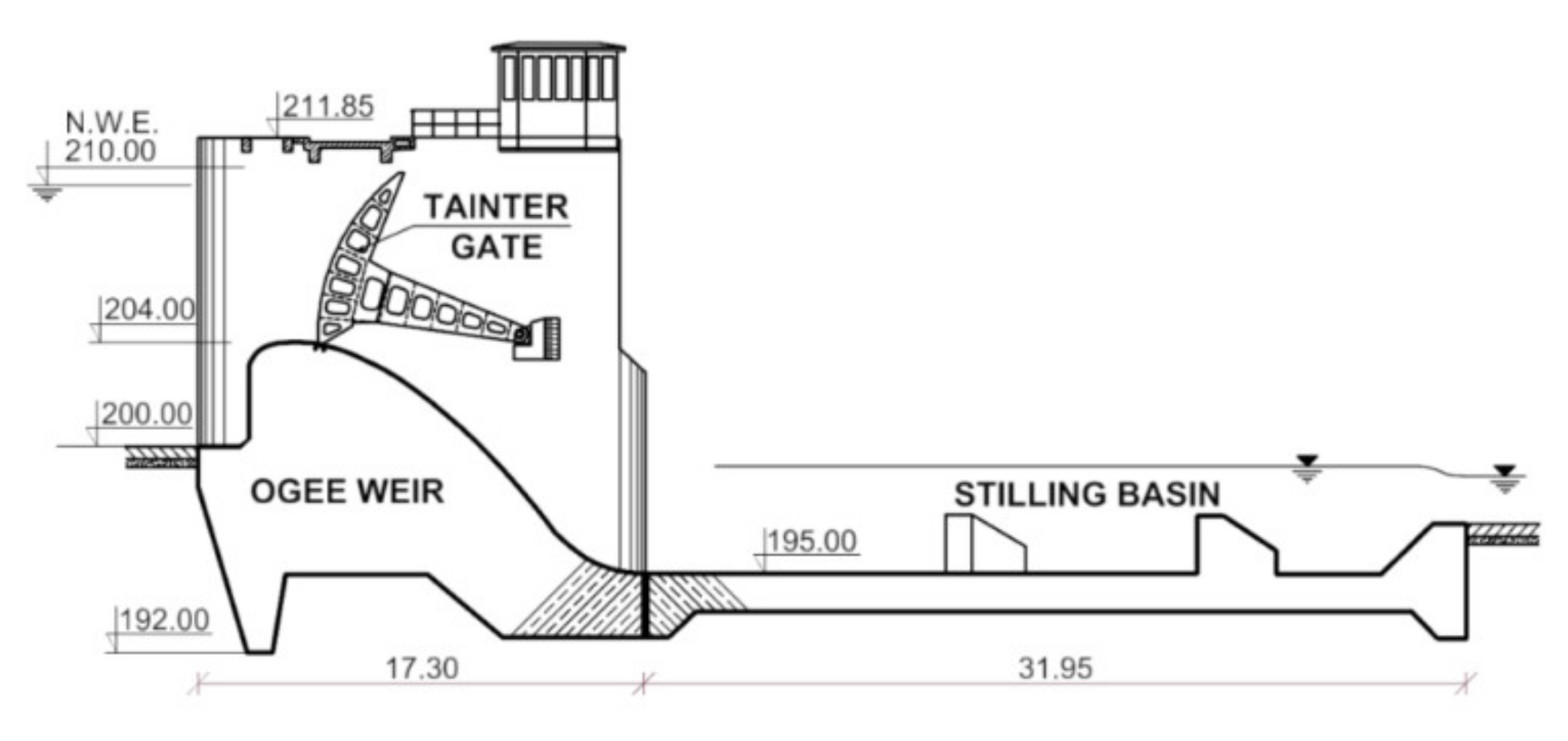
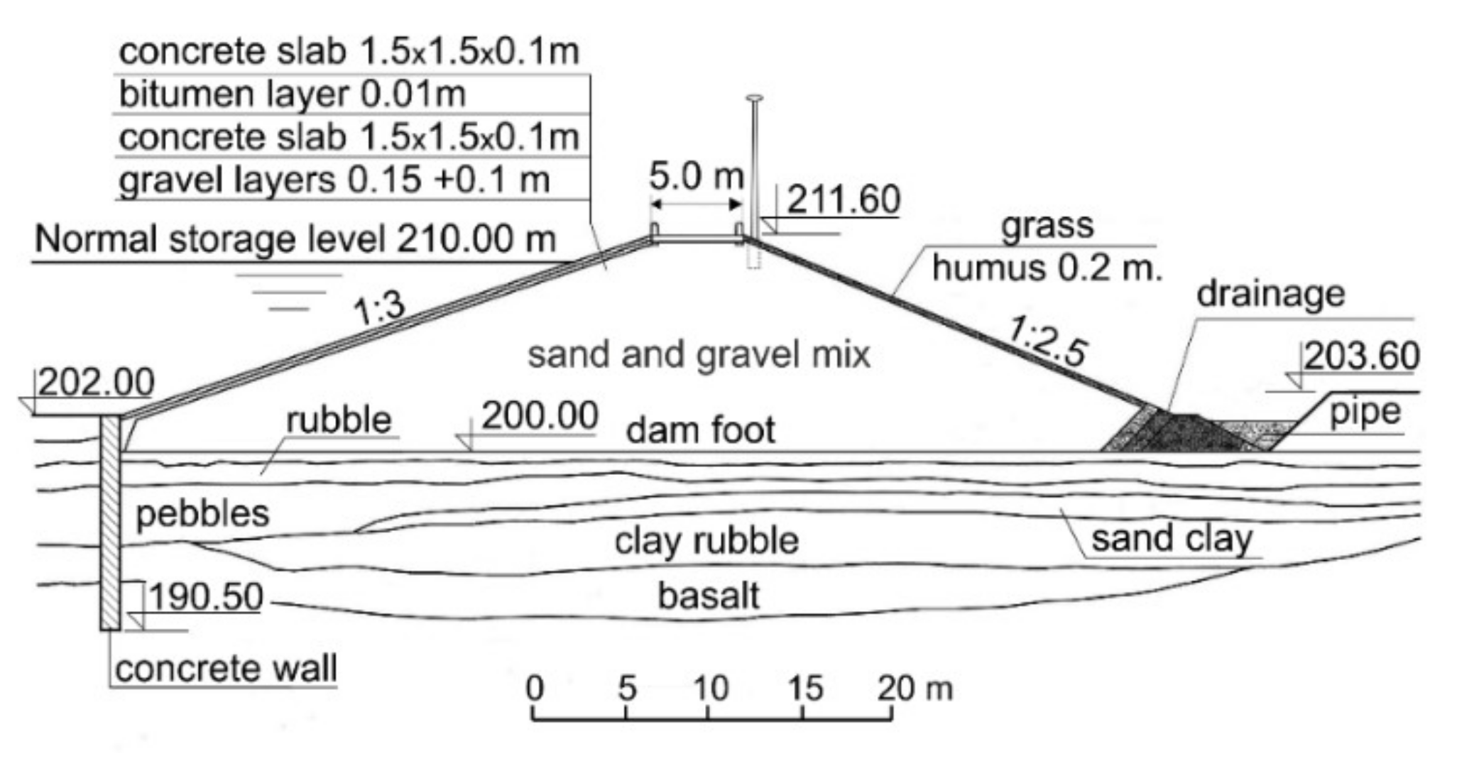
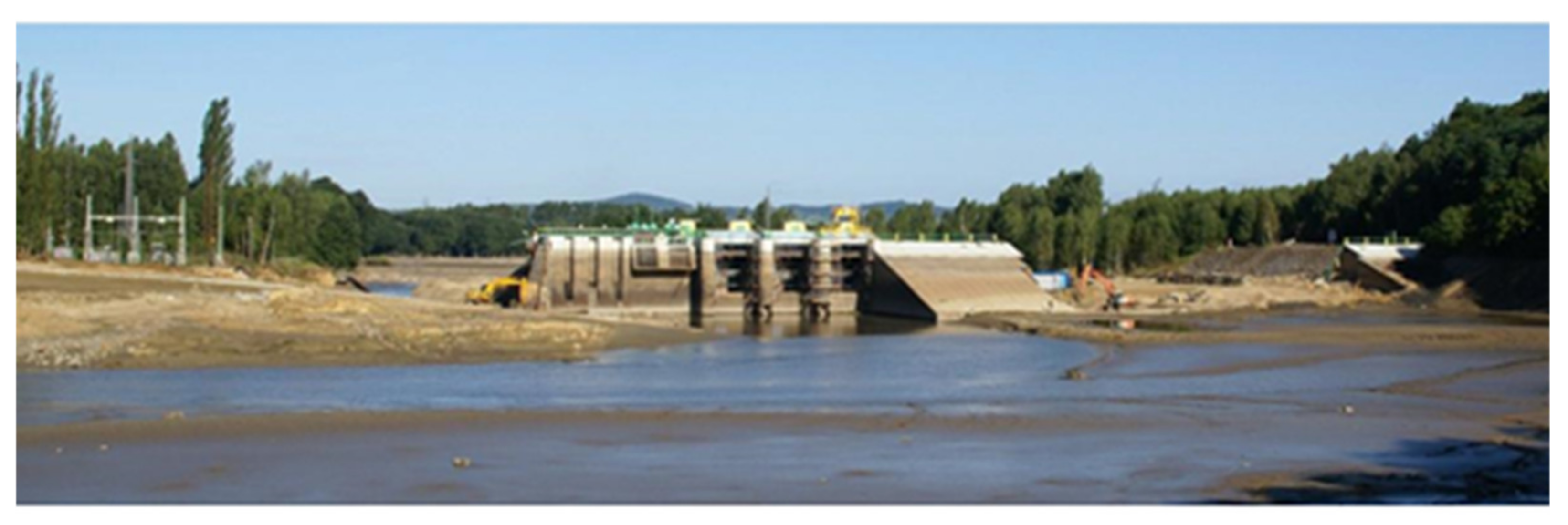
2.2. Description of the Niedów Dam
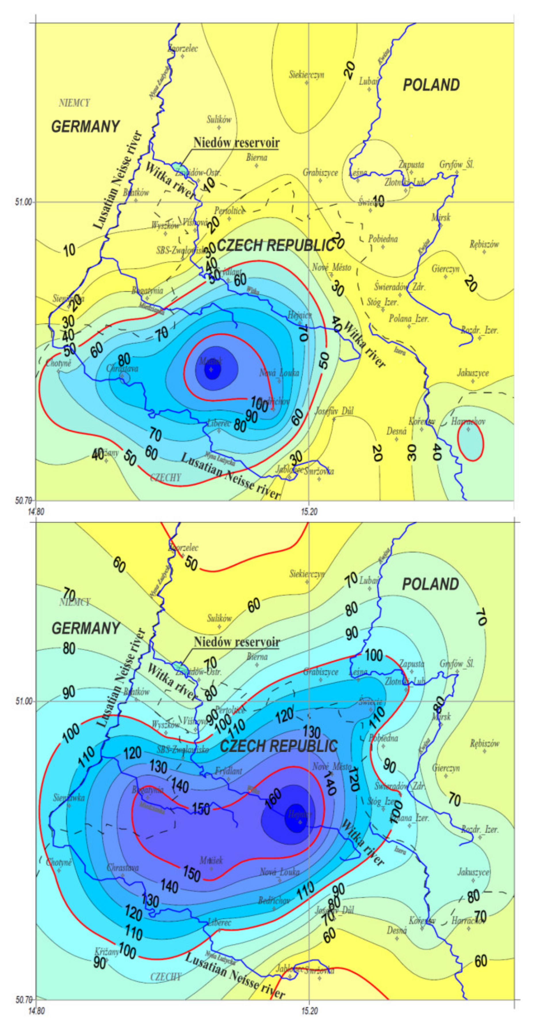
2.3. Meteorological and Hydrological Conditions
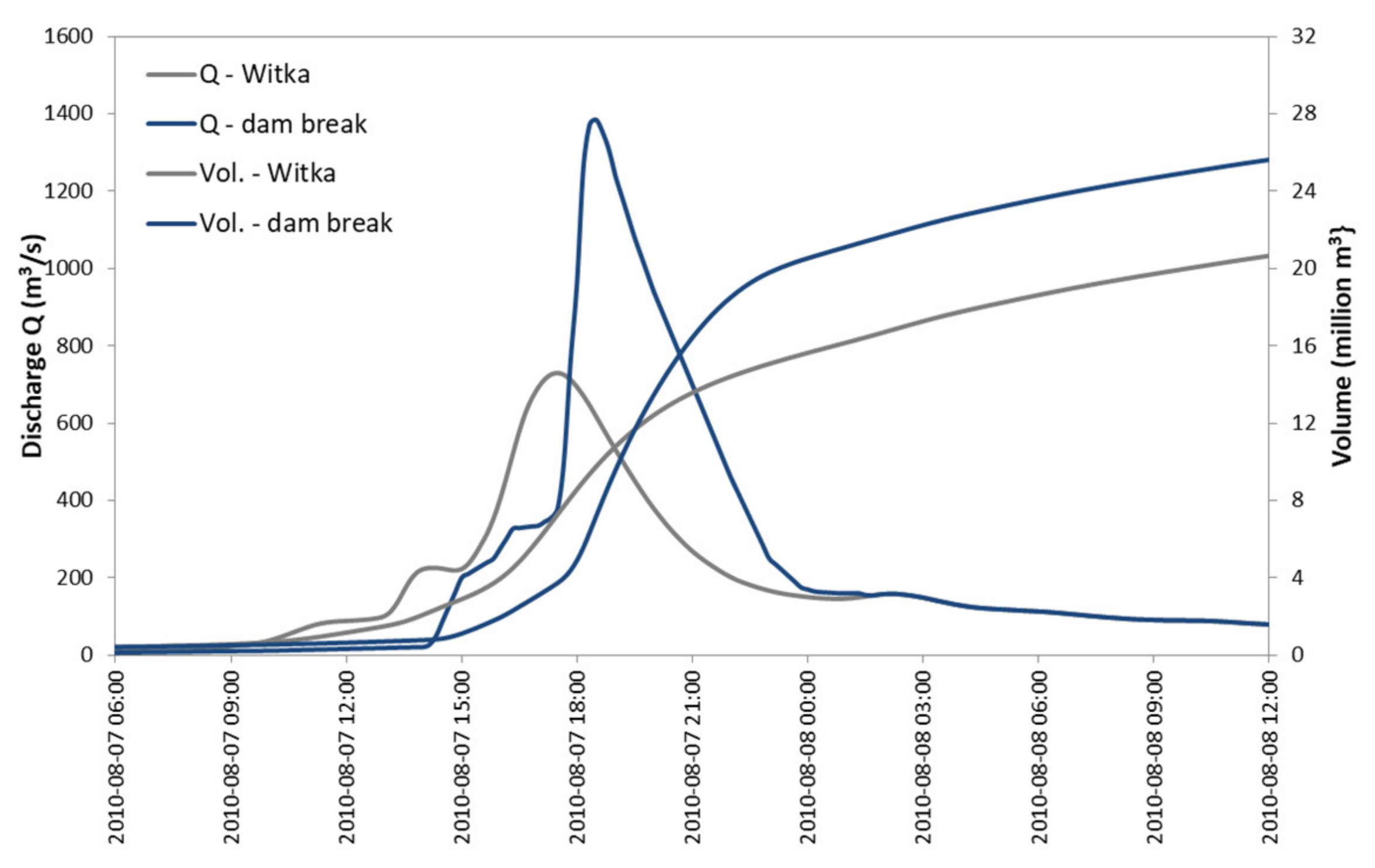
2.4. Dam Failure–Wash Out Mechanism and Breach Characteristics
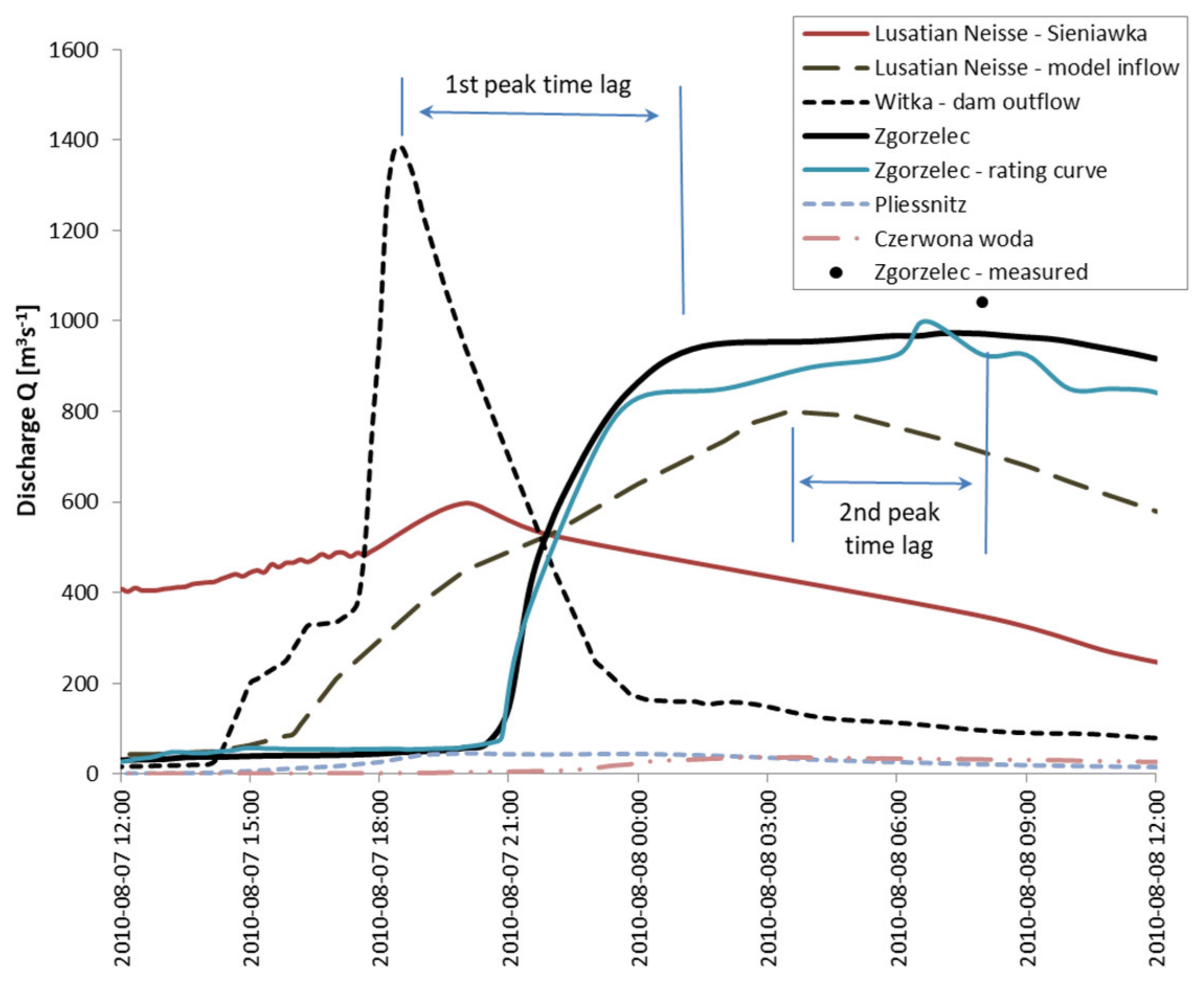
2.5. Flooding Downstream of the Niedów Dam
2.6. Field Observation
3. 2D Modeling of the Food Routing
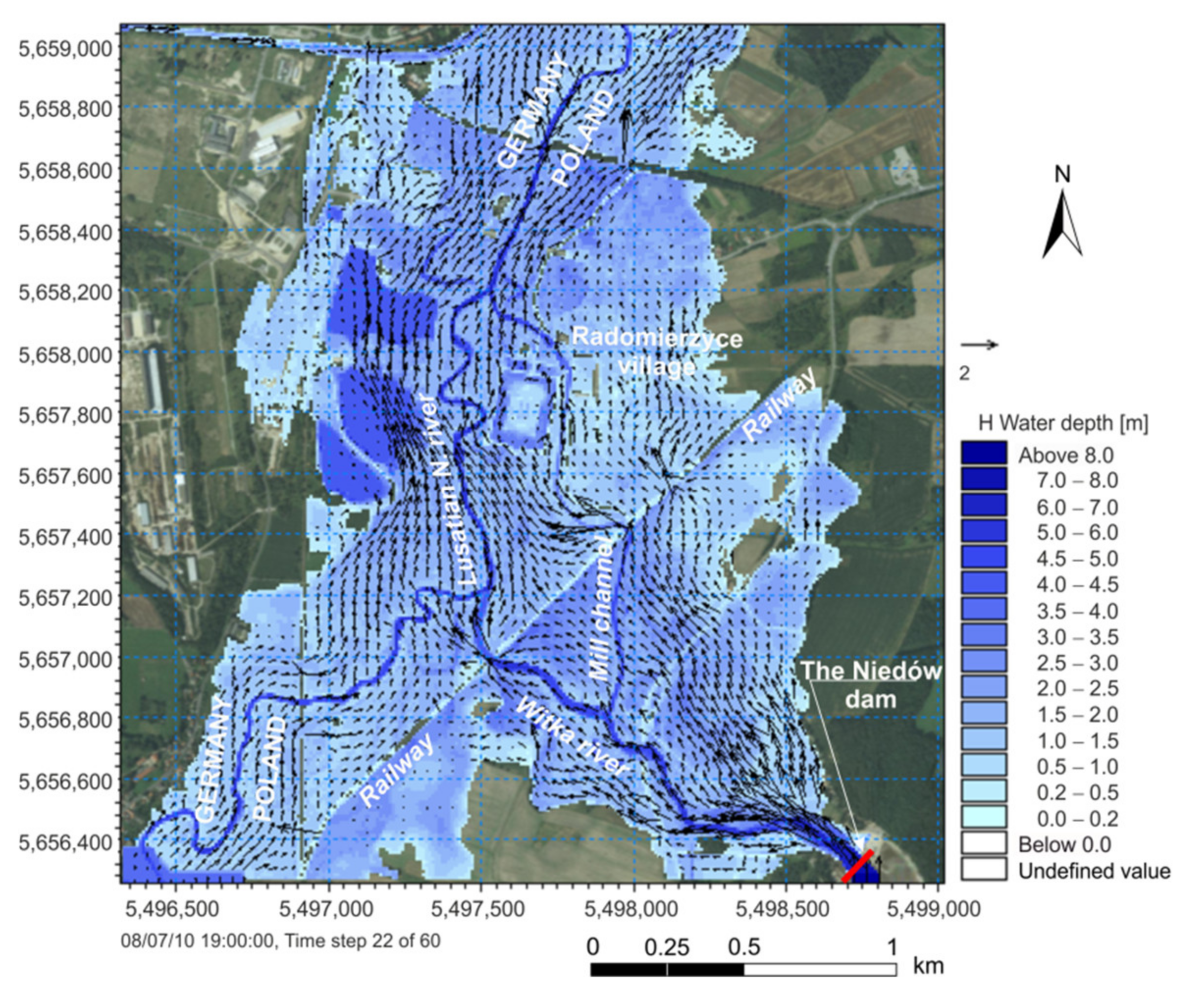
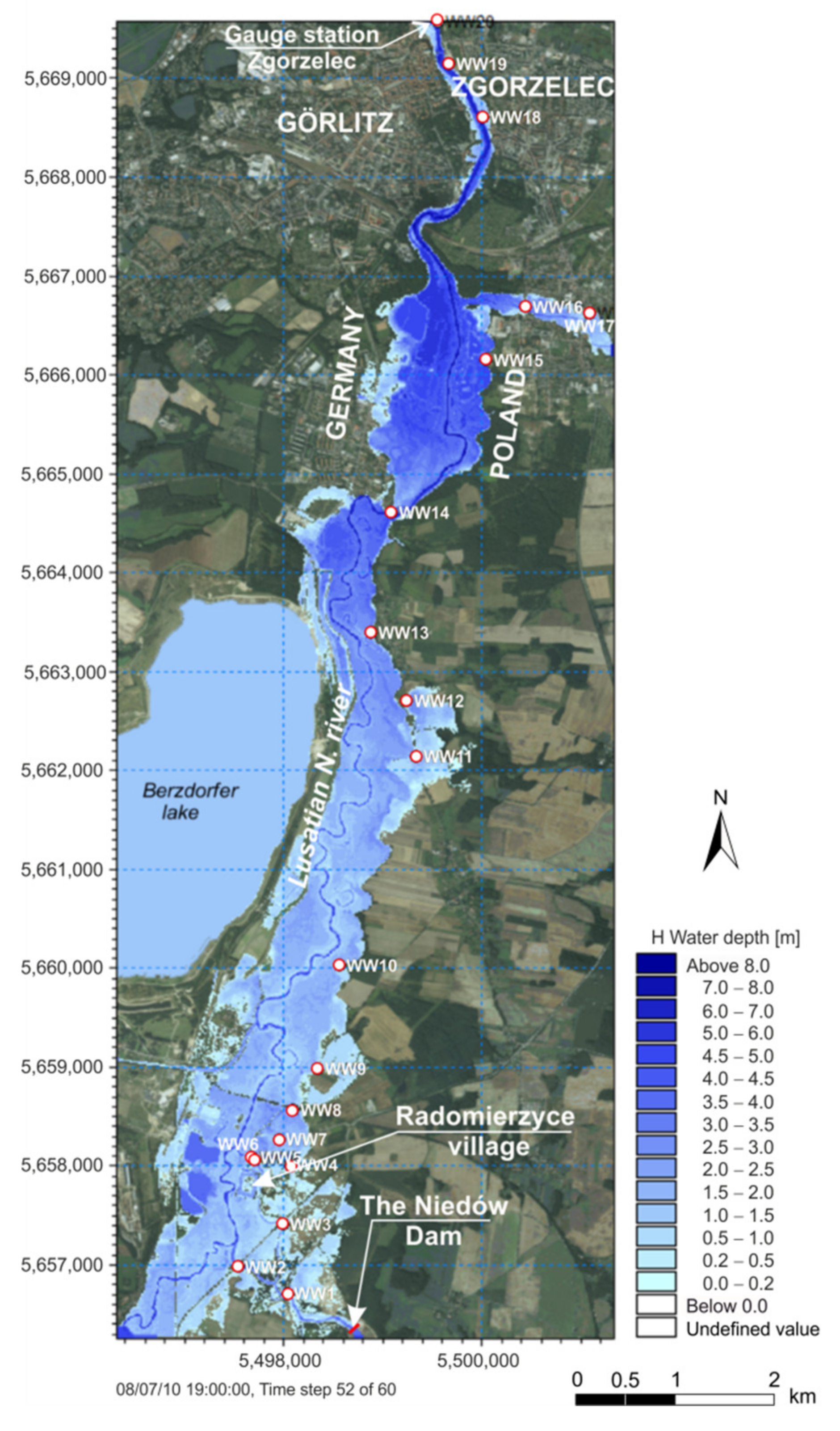
3.1. Model Area and Boundary Conditions
3.2. Model Set Up
3.3. Results Discussion
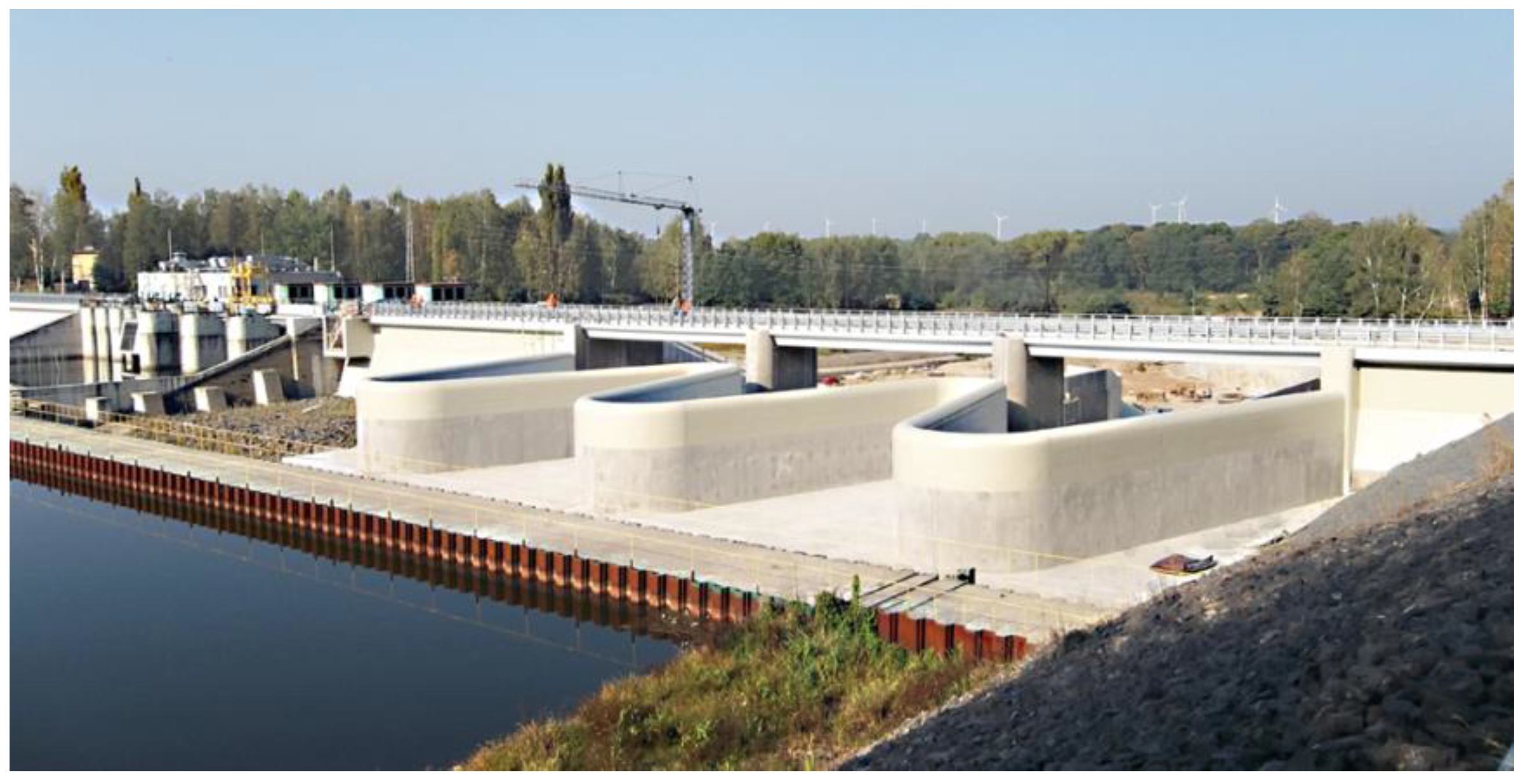
4. The Niedów Dam Restoration
5. Conclusions
Supplementary Materials
Author Contributions
Funding
Institutional Review Board Statement
Informed Consent Statement
Data Availability Statement
Conflicts of Interest
References
- Grant, G. Dam removal: Panacea or Pandora for rivers? Hydrol. Process 2001, 15, 1531–1532. [Google Scholar] [CrossRef]
- Hansen, H.H.; Forzono, E.; Grams, A.; Ohlman, L.; Ruskamp, C.; Pegg, M.A.; Pope, K.L. Exit here: Strategies for dealing with aging dams and reservoirs. Aquat. Sci. 2020, 2, 2–16. [Google Scholar] [CrossRef]
- Ho, M.; Lall, U.; Allaire, M.; Devineni, N.; Kwon, H.H.; Pal, I.; Raff, D.; Wegner, D. The future role of dams in the United States of America. Water Resour. Res. 2017, 53, 982–998. [Google Scholar] [CrossRef]
- ICOLD: Dam Failures—Statistical Analysis; Bulletin 99; International Commission on Large Dams (ICOLD): Paris, France, 1995.
- Ariey, M.; Bridle, R.; Cambridge, M.; Hughes, A.; Sawyer, J.; Spasic-Gril, L.; Williamson, T. Meeting report, ICOLD 2011, Lucerne, Switzerland. Dams Reserv. 2011, 21, 95–100. [Google Scholar] [CrossRef]
- Wu, W. Earthen Embankment Breaching. J. Hydraul. Eng. 2011, 137, 1549–1564. [Google Scholar] [CrossRef]
- Alcrudo, F.; Mulet, J. Description of the Tous Dam break case study (Spain). J. Hydraul. Res. 2007, 45, 45–57. [Google Scholar] [CrossRef]
- Yochum, S.E.; Goertz, L.A.; Jones, P.H. Case study of the Big Bay Dam failure: Accuracy and comparison of breach predictions. J. Hydraul. Eng. 2008, 134, 1285–1293. [Google Scholar] [CrossRef]
- Azeez, O.; Elfeki, A.; Kamis, A.S.; Chaabani, A. Dam break analysis and flood disaster simulation in arid urban environment: The Um Al-Khair dam case study, Jeddah, Saudi Arabia. Nat. Hazards 2020, 100, 995–1011. [Google Scholar] [CrossRef]
- Begnudelli, L.; Sanders, B.F. Simulation of the St. Francis Dam-Break Flood. J. Eng. Mech. 2007, 133, 1200–1212. [Google Scholar] [CrossRef]
- Pilotti, M.; Maranzoni, A.; Tomirotti, M.; Velerio, G. 1923 Gleno Dam Break: Case Study and Numerical Modeling. J. Hydraul. Eng. 2011, 137, 480–492. [Google Scholar] [CrossRef]
- Bureau of Reclamation. Downstream Hazard Classification Guidelines; ACER Tech. Memorandum Rep, No. 11; U.S. Department of the Interior, Bureau of Reclamation: Denver, CO, USA, 1988.
- Froehlich, D.C. Embankment Dam Breach Parameters and Their Uncertainties. J. Hydraul. Eng. 2008, 134, 1708–1721. [Google Scholar] [CrossRef]
- Xu, Y.; Zhang, L.M. Breaching Parameters for Earth and Rockfill Dams. J. Geotech. Geoenviron. Eng. 2009, 135, 1957–1970. [Google Scholar] [CrossRef]
- Zhang, L.M.; Xu, Y.; Jia, J.S. Analysis of earth dam failures: A database approach. Georisk 2009, 3, 184–189. [Google Scholar] [CrossRef]
- Kostecki, S.; Rędowicz, W. The washout mechanism of the Niedów Dam and its impact on the parameters of the flood wave. Procedia Eng. 2014, 91, 292–297. [Google Scholar] [CrossRef][Green Version]
- DHI: MIKE 11—A modeling system for Rivers and Channels. In User Manual; DHI Water Environment Health: Hørsholm, Denmark, 2011.
- Saberi, O. Embankment Dam Failure Outflow Hydrograph Development. Ph.D. Thesis, Graz University of Technology, Graz, Austria, 2016; p. 159. [Google Scholar]
- Borowicz, A.; Urbański, M. Hydraulic Model for the Witka River and the Niedów Reservoir—The Niedów Dam Failure during the Flood in August 2010 and the Determination of Flooded Area; Wrocław University of Science and Technology: Wrocław, Poland, 2011. (In Polish) [Google Scholar]
- Altinakar, M. Modeling Tools for Dam Break Analysis. In Mississippi: National Center for Computational Hydroscience and Engineering; University of Mississippi: Oxford, MS, USA, 2008. [Google Scholar]
- Cleary, P.W.; Prakash, M.; Mead, S.; Tang, X.; Wang, H.; Ouyang, S. Dynamic simulation of dam-break scenarios for risk analysis and disaster management. Int. J. Image Data Fusion 2012, 3, 333–363. [Google Scholar] [CrossRef]
- Cleary, P.W.; Prakash, M.; Mead, S.; Lemiale, V.; Robinson, G.K.; Ye, F.; Ouyang, S.; Tang, X. A scenario-based risk framework for determining consequences of different failure modes of earth dams. Nat. Hazards 2015, 75, 1489–1530. [Google Scholar] [CrossRef]
- Cannata, M.; Marzocchi, R. Two-dimensional dam break flooding simulation: A GIS-embedded approach. Nat. Hazards 2012, 61, 1143–1159. [Google Scholar] [CrossRef]
- Álvarez, M. Two-Dimensional Dam-Break Flood Analysis in Data-Scarce Regions: The Case Study of Chipembe Dam, Mozambique. Water 2017, 9, 432. [Google Scholar] [CrossRef]
- Zhong, D. Dam break threshold value and risk probability assessment for an earth dam. Nat. Hazards 2011, 59, 129–147. [Google Scholar] [CrossRef]
- Teng, J.; Jakeman, A.J.; Vaze, J.; Croke, B.F.W.; Dutta, D.; Kim, S. Flood inundation modelling: A review of methods, recent advances and uncertainty analysis. Environ. Model. Softw. 2017, 90, 201–216. [Google Scholar] [CrossRef]
- Tayefi, V.; Lane, S.N.; Hardy, R.J.; Yu, D. A comparison of one- and two-dimensional approaches to modelling flood inundation over complex upland floodplains. Hydrol. Process. 2007, 21, 3190–3202. [Google Scholar] [CrossRef]
- Vanderkimpen, P.; Peeters, P. Flood modeling for risk evaluation: A MIKE FLOOD sensitivity analysis. In Proceedings of the International Conference on Fluvial Hydraulics (River Flow 2008), Çeșme, Izmir, Turkey, 3–5 September 2008; pp. 2335–2344. [Google Scholar]
- Saberi, O.; Dorfman, C.; Zenz, G. 2-D Hydraulic Modelling of a Dam Break Scenario. Conference: ICOLD 2013. 2013. Available online: https://www.researchgate.net/publication/311807694 (accessed on 15 October 2021).
- Yakti, B.P.; Adityawan, M.B.; Farid, M.; Suryadi, Y.; Nugroho, J.; Hadihardaja, I.K. 2D Modeling of Flood Propagation Due to the Failure of Way Ela Natural Dam. MATEC Web of Conferences 147. 2018. Available online: https://www.matec-conferences.org/articles/matecconf/abs/2018/06/matecconf_sibe2018_03009/matecconf_sibe2018_03009.html (accessed on 15 October 2021).
- Banasiak, R. 1D or/and 2D numerical modelling of river flood—Practical approaches towards flood hazard mapping for the Odra River, Poland. In Proceedings of the 6th IAHR Europe Congress, Warsaw, Poland, 15–18 February 2021. [Google Scholar]
- Shah, M.R.M.; Sidek, L.M.; Yalit, M.R.; Marufuzzaman, M.; Basri, H.; Yaacob, K.M. 2D Hydraulic Modelling of Dam Break Analysis Using MIKE FLOOD for Kenyir Dam. In ICDSME 2019. Proceedings of the 1st International Conference on Dam Safety Management and Engineering (Water Resources Development and Management); Sidek, L., Salih, G.H.A., Boosroh, M.H., Eds.; Springer: Singapore, 2019. [Google Scholar] [CrossRef]
- Jelonek, L.; Wrzeszcz, L.; Zawiślak, J.; Walther, P.; Winkler, U.; Wortha, S.; Srejber, J.; Petr, J. Common Polish, Czech and German Report on the Flood Event on 7–10 August 2010 on the Nysa Łużycka River for the Preliminary Flood Risk Assessment Conform with the EU Art. 4 Flood Directive (2007/60/EG); Institute of Meteorology and Water Management (IMGW): Wrocław, Poland, 2010. (In Polish) [Google Scholar]
- Flood: Zgorzelec under water. Gazeta.pl. Available online: https://www.youtube.com/watch?v=UEFCJWT6HtQ (accessed on 15 October 2021).
- Tokarczyk, T.; Banasiak, R.; Bogusz, A.; Orczykowski, T.; Zdralewicz, M. Assessment of the Niedów Dambreak on the Flood Wave Propagation on the Lusatian Neisse on the Section between the Witka River and the Zgorzelec Gauging Station; Institute of Meteorology and Water Management (IMGW): Wrocław, Poland, 2011. (In Polish) [Google Scholar]
- McCowan, A.D.; Rasmussen, E.B.; Berg, P. Improving the Performance of a Two-dimensional Hydraulic Model for Floodplain Applications. The Institution of Engineers, Australia. Conference on Hydraulics in Civil Engineering, Hobart 28–30 November, Models. Nat. Hazards 2001, 84, 1385–1418. [Google Scholar]
- Kho, F.W.L.; Law, P.L.; Lai, S.H.; Oon, Y.W.; Ngu, L.H.; Ting, H.S. Quantitative dam break analysis on a reservoir earth dam. Int. J. Environ. Sci. Tech. 2009, 6, 203–210. [Google Scholar] [CrossRef]
- Ahmad, S.; Simonović, S.P. Comparison of One-Dimensional and Two-Dimensional Hydrodynamic Modeling Approaches for Red River Basin; Final Report to International Joint Commission; University of Manitoba: Winnipeg, MB, Canada, 1999. [Google Scholar]
- DHI: MIKE21 Flow Model & MIKE 21 Flood Screening Tool. In Hydrodynamic Module; Scientific Documentation: Hørsholm, Denmark, 2017.
- Arcement, G.J.; Schneider, V.R. Guide for selecting Manning’s roughness coefficients for natural channels and flood plains. U.S. Geological Survey. In Water Supply Paper; U.S. Government Publishing Office, Federal Center: Denver, CO, USA, 1989; Volume 2339. [Google Scholar] [CrossRef]
- Morvan, H.; Knight, D.; Wright, N.; Tang, X.; Crossley, A. The concept of roughness in fluvial hydraulics and its formulation in 1D, 2D and 3D numerical simulation models. J. Hydraul. Res. 2008, 46, 191–208. [Google Scholar] [CrossRef]
- Hall, J.W.; Tarantola, S.; Bates, P.D.; Horritt, M.S. Distributed sensitivity analysis of flood inundation model calibration. J. Hydraul. Eng. 2005, 131, 117e126. [Google Scholar] [CrossRef]
- Pappenberger, F.; Beven, K.; Horritt, M.; Blazkova, S. Uncertainty in the calibration of effective roughness parameters in HEC-RAS using inundation and downstream level observations. J. Hydrol. 2005, 302, 46–69. [Google Scholar] [CrossRef]


| Time | Development |
|---|---|
| 15:0 | Outflow from the reservoir–86.1 m3s−1, WL–210.02 m a.s.l., gates I, II, and III open 0.60, 0.61, 0.56 m, respectively. |
| 16:00 | Outflow from the reservoir–261.1 m3s−1, WL 210.21 m a.s.l., gates I, II, and III open 1.50, 1.70, 2.50 m, respectively. |
| 16:10 | A rapid rise in the water level in the reservoir. |
| 16:18 | Water inflow into the power plant and the control room, crew evacuation to the top of the dam, and continuation of manual opening of the gates. |
| 16:40 | The maximum water level at Ostróżno gauge station. |
| 17:00 | Beginning of the flow over the left dam, crew evacuated to the shore of the reservoir, gates I and III open 250 cm, II open 200 cm, outflow 352 m3s−1. |
| 17:15 | Beginning of the flow over the right dam. |
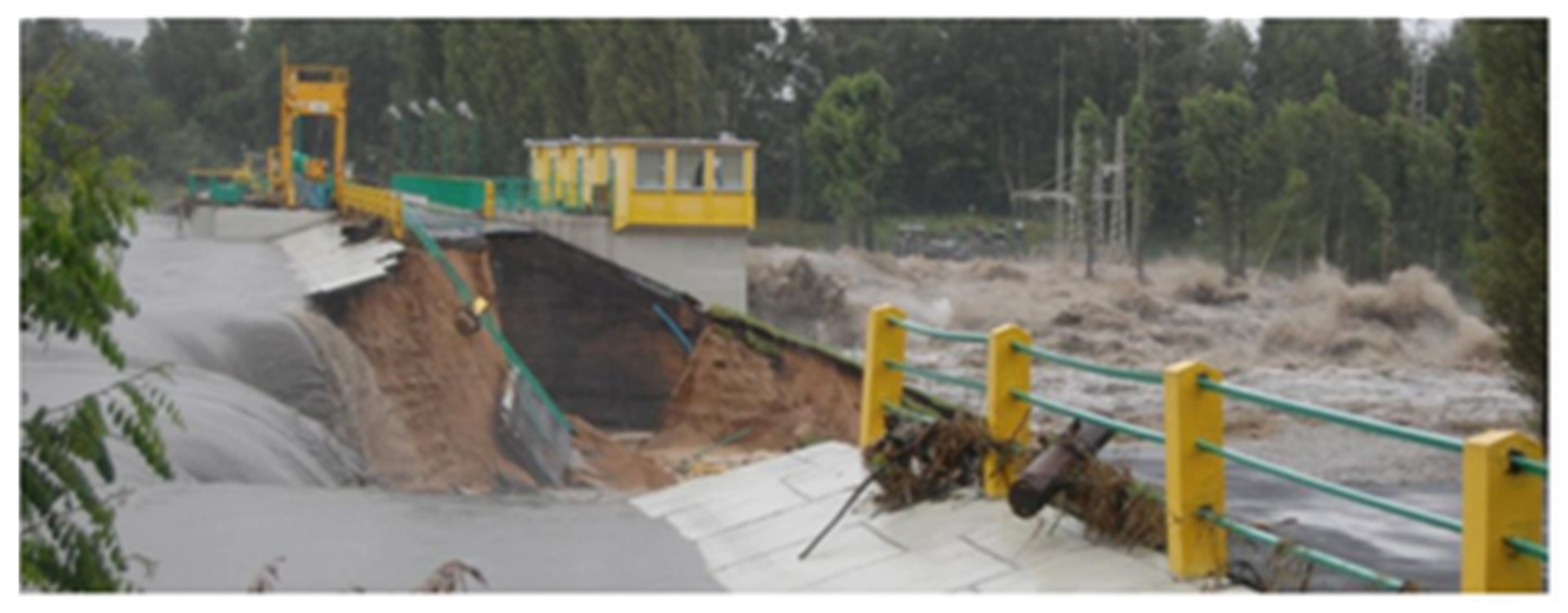
| 17:42 | Water level reaches a maximum of 212.05 m a.s.l. Washing-out of the lee side of the dam, destruction of the road on top of the dam with a length of 40 m on the left side and 30 m on the right side. |
| 18:10 | Water level at 211.60 m a.s.l. The breaching likely reached the dam floor. The collapse of the headwall of the left dam resulted in immense outflow through the breach. |
| 18:47 | The breach of the left dam is finished. The dam is washed out on a length of 106 m. |
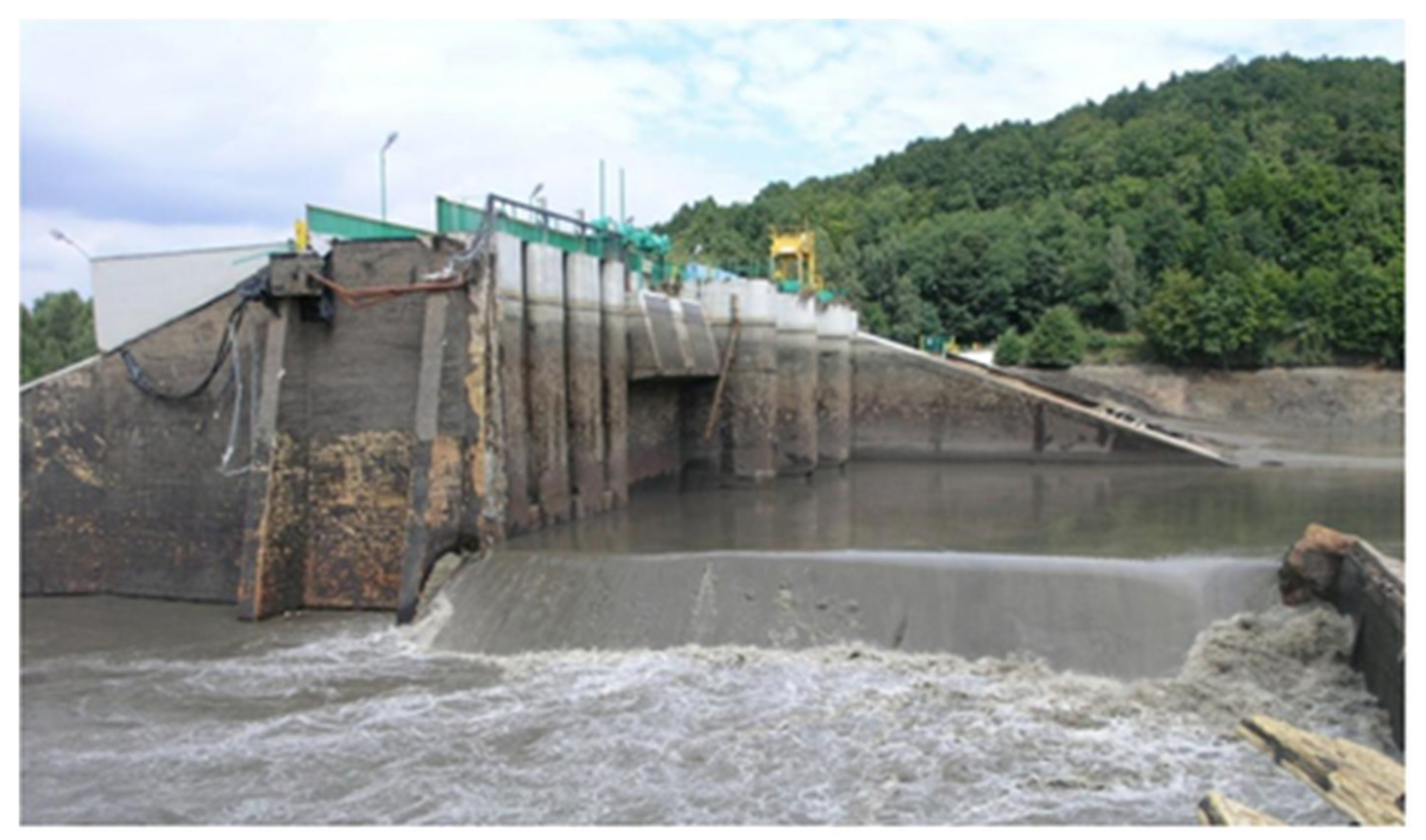
| 18:56 | Water level-209.00 m a.s.l. The right dam continues breaching. |
| 19:25 | The breach of the right dam is complete. The dam is washed out with a width of 58 m. The reservoir releases the remaining water. |
| 21:00 | The reservoir became empty. |
| Hydraulic Characteristics | ||||
|---|---|---|---|---|
| Reservoir Storage to the Crest Level | Surface Area to the Crest Level | Volume Stored Related to Hw | Depth behind Dam at Breach Inception | Peak Discharge |
| V | A | Vw | Hw | Qp |
| (million m3) | (m2) | (m3) | (m) | (m3s−1) |
| 8.310 | 1,900,000 | 8,541,000 | 11.70 | 1380 * |
| Embankment Dimensions | ||||
| Left Dam | Right Dam | |||
| Hd | m | 11.6 | 11.6 | |
| Crest width | Wc | m | 5.0 | 5.0 |
| Bottom width | Wb | m | 68.8 | 68.8 |
| Average width | Wavg | m | 43.5 | 57.25 |
| Upstream slope | Z:1 | - | 0.333 | 0.333 |
| Downstream slope | Z:1 | - | 0.4 | 0.4 |
| Breach Characteristics | ||||
| Left Dam | Right Dam | |||
| Depth above breach (max) | Hb | m | 11.6 | 11.6 |
| Hbavg | m | 6.0 | 9.7 | |
| Top width | Bt | m | 106.0 | 58.0 |
| Bottom width | Bb | m | 21.8 | 58.0 |
| Average width | Bavg | m | 64.0 | 58.0 |
| Eroded volume | Ver | m3 | 25,130 | 20,860 |
| Tf | h | 1.78 | 2.16 | |
| Te | h | 3.0 | 2.75 | |
| Water Marks | H Measured (m) | H Calculated (m) | Difference (m) |
|---|---|---|---|
| WW1 | 200.73 | 200.656 | −0.074 |
| WW2 | 199.04 | 199.121 | 0.081 |
| WW3 | 199.63 | 199.539 | −0.091 |
| WW4 | 197.72 | 197.618 | −0.102 |
| WW5 | 198.03 | 197.470 | −0.56 |
| WW6 | 197.66 | 197.382 | −0.278 |
| WW7 | 197.56 | 197.383 | −0.177 |
| WW8 | 197.22 | 197.327 | 0.107 |
| WW9 | 195.17 | 195.09 | −0.08 |
| WW10 | 193.91 | 193.942 | 0.032 |
| WW11 | 191.53 | 191.312 | −0.218 |
| WW12 | 191.36 | 191.125 | −0.235 |
| WW13 | 190.22 | 190.008 | −0.212 |
| WW14 | 189.09 | 189.203 | 0.113 |
| WW15 | 188.31 | 188.466 | 0.156 |
| WW16 | 188.53 | 188.463 | −0.067 |
| WW17 | 188.77 | 188.727 | −0.043 |
| WW18 | 185.43 | 185.498 | 0.068 |
| WW19 | 184.79 | 184.658 | −0.132 |
| WW20 | 182.77 | 182.754 | −0.0 |
Publisher’s Note: MDPI stays neutral with regard to jurisdictional claims in published maps and institutional affiliations. |
© 2021 by the authors. Licensee MDPI, Basel, Switzerland. This article is an open access article distributed under the terms and conditions of the Creative Commons Attribution (CC BY) license (https://creativecommons.org/licenses/by/4.0/).
Share and Cite
Kostecki, S.; Banasiak, R. The Catastrophe of the Niedów Dam—The Causes of the Dam’s Breach, Its Development, and Consequences. Water 2021, 13, 3254. https://doi.org/10.3390/w13223254
Kostecki S, Banasiak R. The Catastrophe of the Niedów Dam—The Causes of the Dam’s Breach, Its Development, and Consequences. Water. 2021; 13(22):3254. https://doi.org/10.3390/w13223254
Chicago/Turabian StyleKostecki, Stanisław, and Robert Banasiak. 2021. "The Catastrophe of the Niedów Dam—The Causes of the Dam’s Breach, Its Development, and Consequences" Water 13, no. 22: 3254. https://doi.org/10.3390/w13223254
APA StyleKostecki, S., & Banasiak, R. (2021). The Catastrophe of the Niedów Dam—The Causes of the Dam’s Breach, Its Development, and Consequences. Water, 13(22), 3254. https://doi.org/10.3390/w13223254