
Highwater Mark Collection after Post Tropical Storm Dorian and Implications for Prince Edward Island, Canada


Abstract
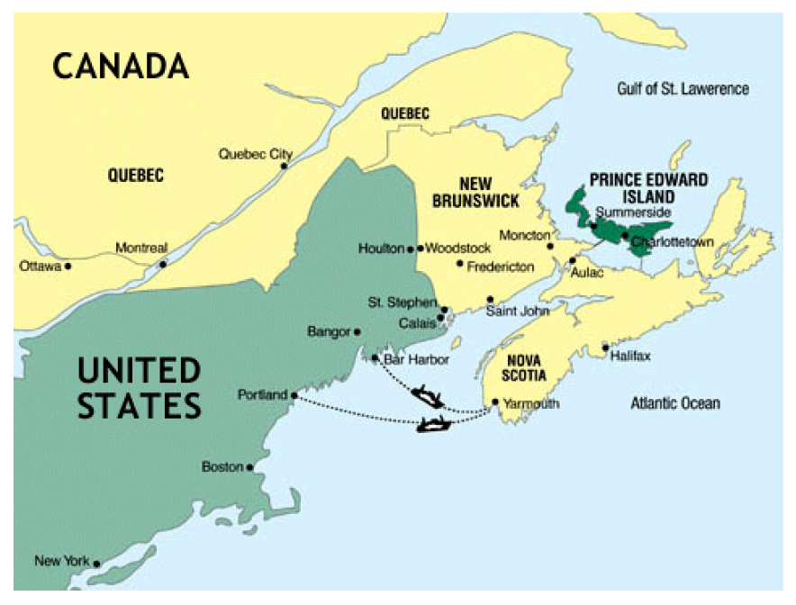
:1. Introduction
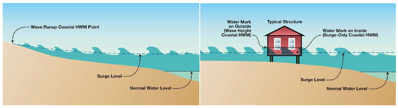
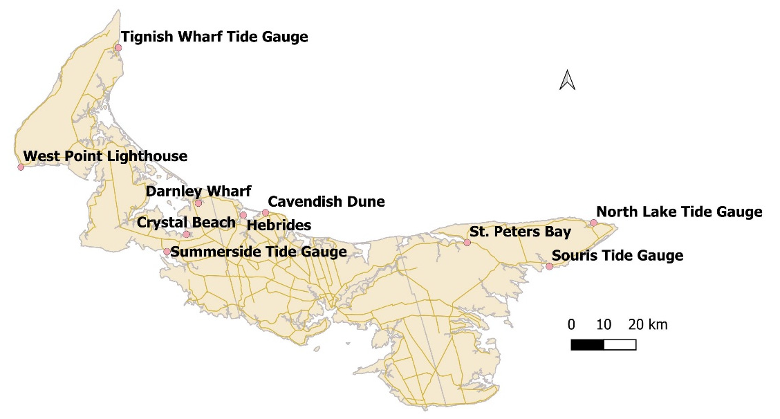
2. Materials and Methods
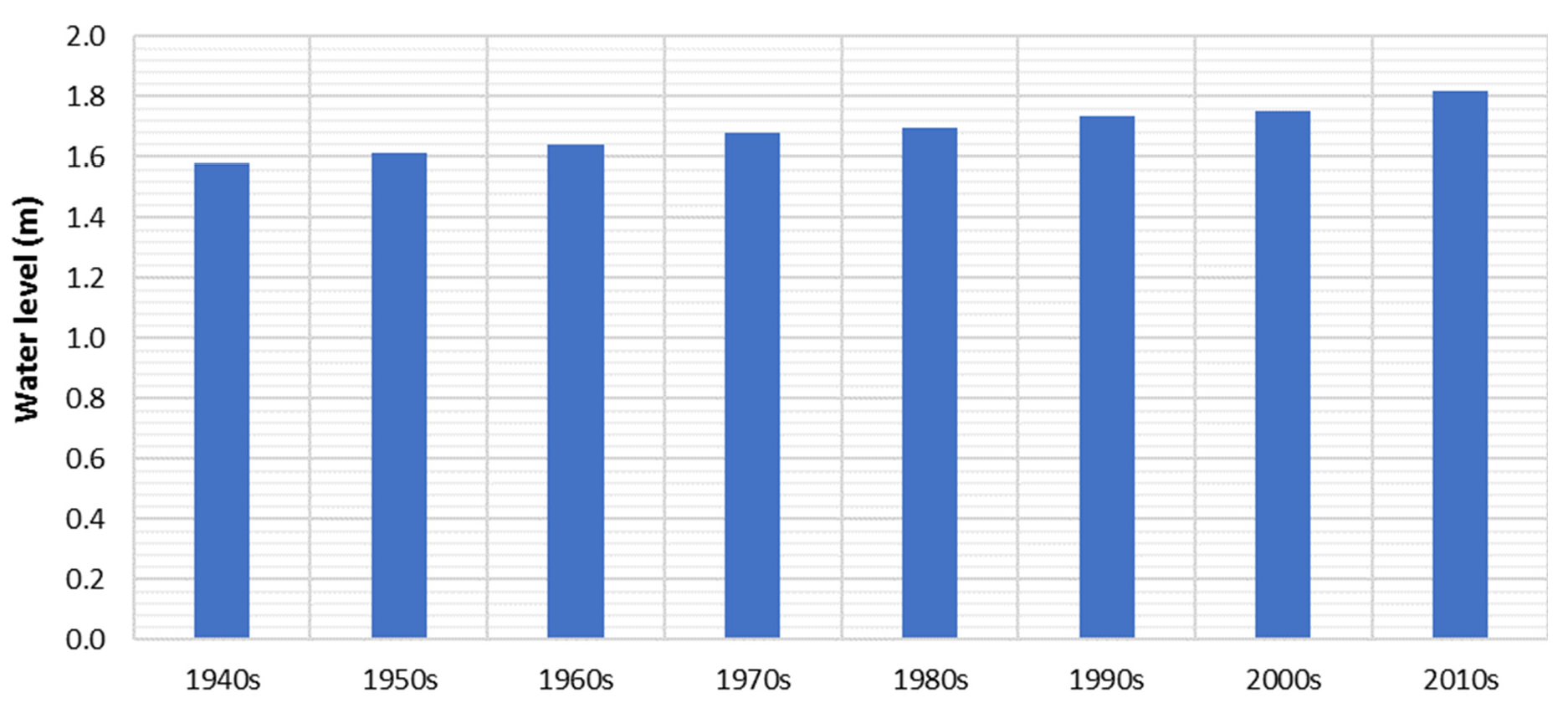
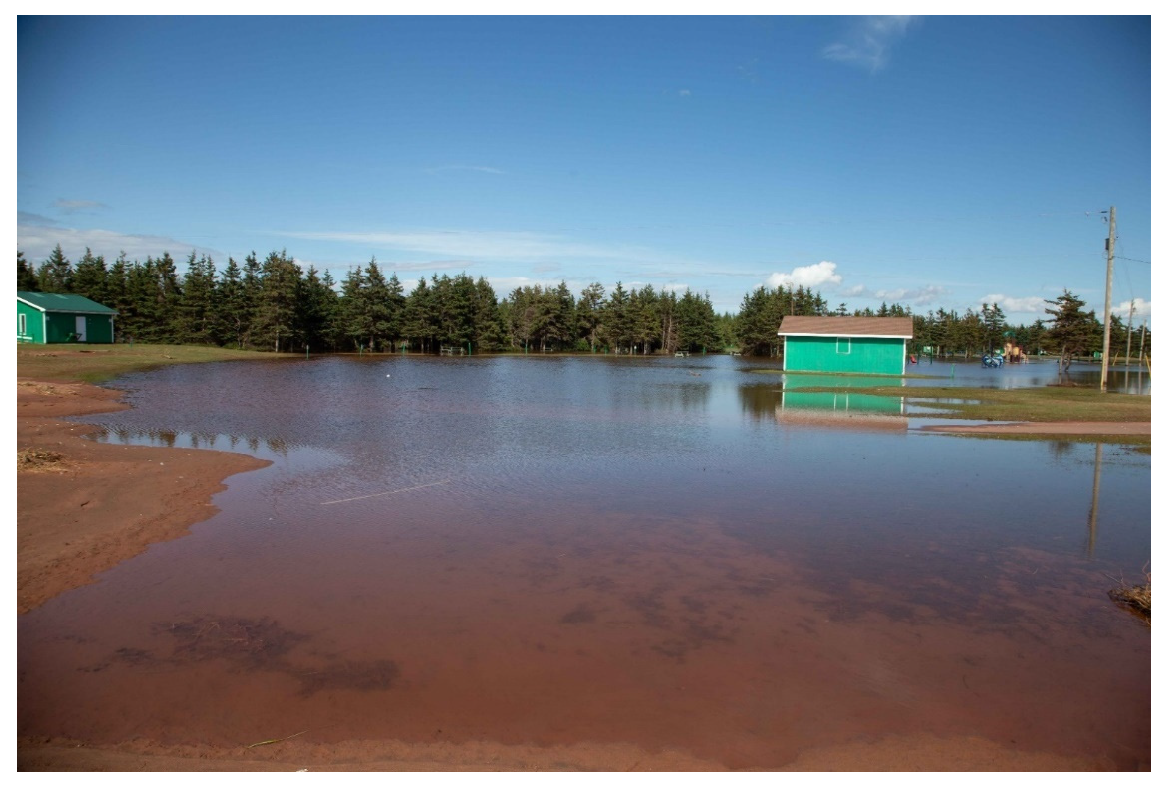
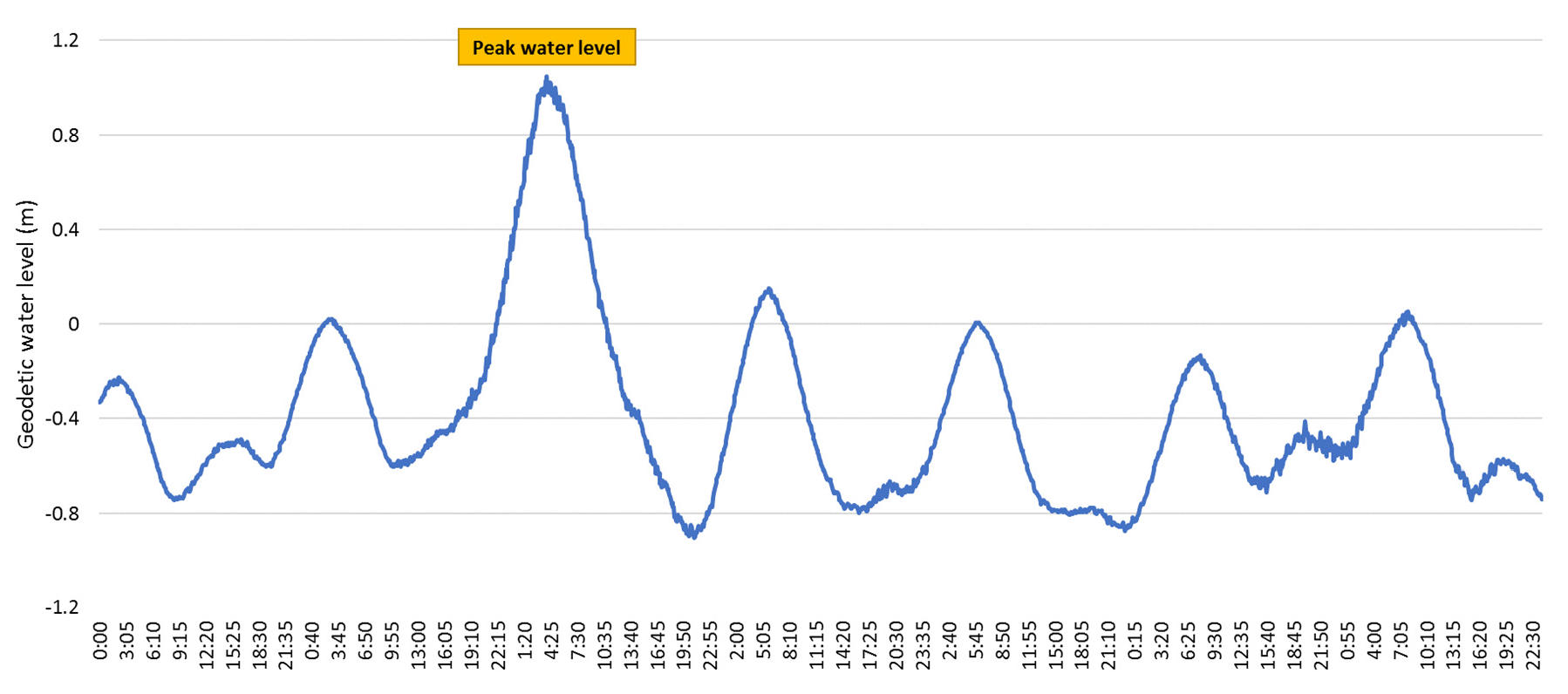
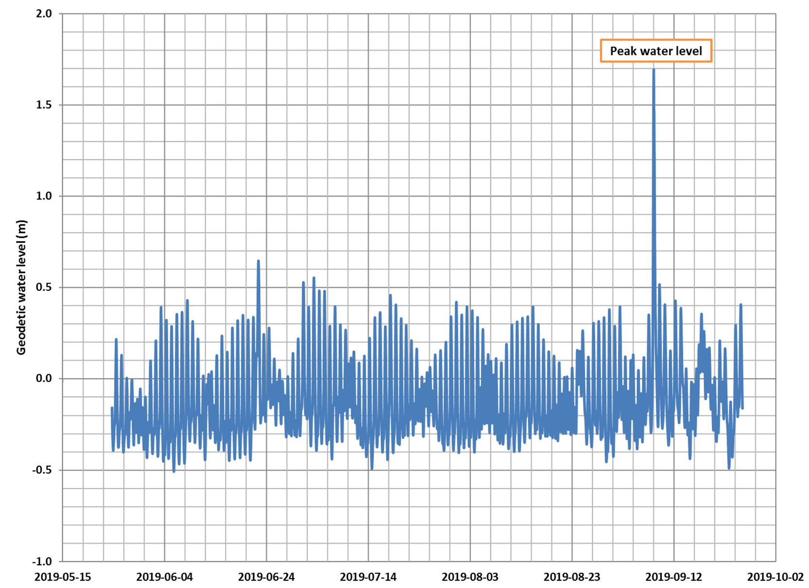
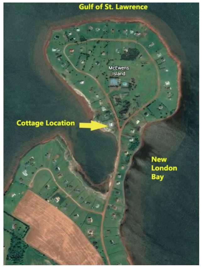
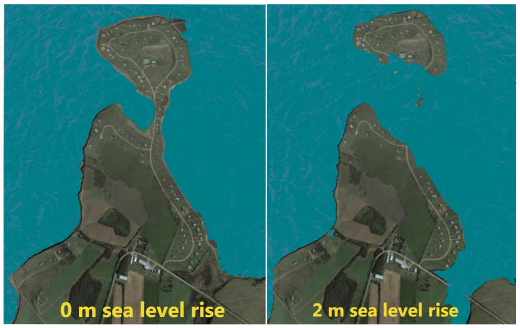
3. Results and Discussion
4. Conclusions
Author Contributions
Funding
Institutional Review Board Statement
Informed Consent Statement
Data Availability Statement
Conflicts of Interest
Appendix A

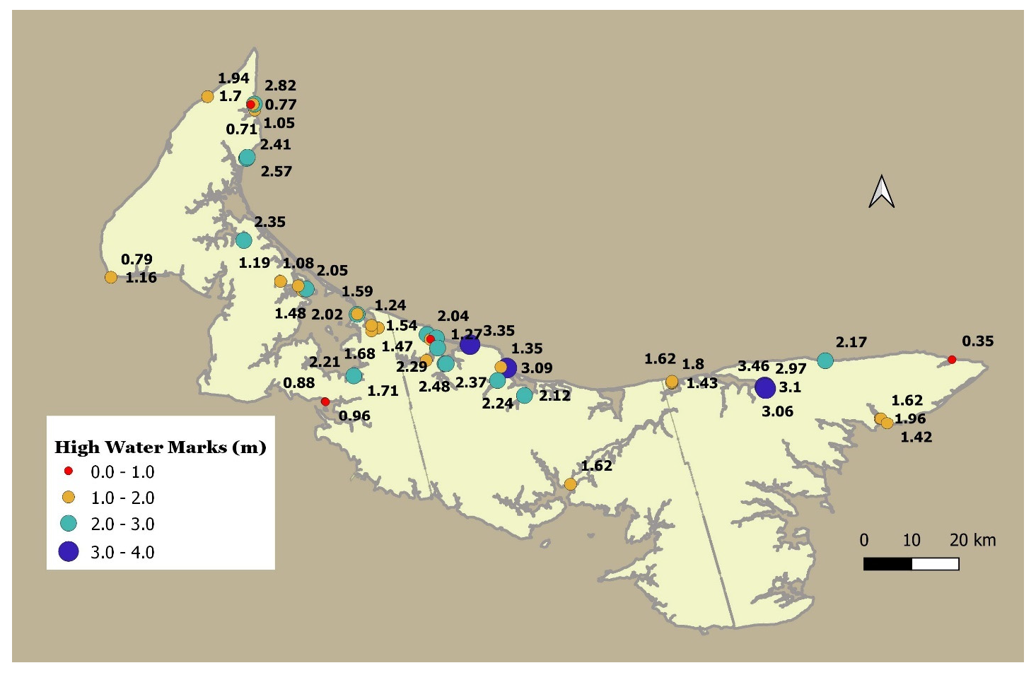
| Location | Longitude | Latitude | Geodetic High-Water Level (CGVD28) (m) | Vertical * Precision (m) | Category (as Defined by URS Group, 2006) |
|---|---|---|---|---|---|
| Baltic River at Cousins field | −63.6459 | 46.5299 | 1.24 | 0.10 | Surge only |
| Bideford Wharf | −63.9165 | 46.6165 | 1.19 | 0.07 | Surge only |
| Cavendish Beach at dune wrack line | −63.3934 | 46.4993 | 3.35 | 0.03 | Wave Runup on dune, Wave Height |
| Charlottetown −1700 tide gauge | −63.1167 | 46.2333 | 1.62 | - | Stilling well |
| Crystal Beach, Lower New Annan—field | −63.7117 | 46.4370 | 1.71 | 0.04 | Surge only |
| Crystal Beach, Lower New Annan—Shore area | −63.7122 | 46.4384 | 2.21 | 0.05 | Wave runup onto shallow cliff |
| Darnley Wharf Tide Gauge | −63.6645 | 46.5242 | 1.68 | - | Stilling well |
| Darnley Wharf Wrack line | −63.6647 | 46.5347 | 1.54 | 0.04 | Wave height. |
| Foxley River—Phillips | −64.0190 | 46.6933 | 2.35 | 0.04 | Surge only |
| French River Wharf Road | −63.5118 | 46.5179 | 2.04 | 0.05 | Wave height |
| French River Cannery Wrack Line at Road | −63.5025 | 46.5088 | 1.27 | 0.12 | Wave height |
| French River Lighthouse at Dune | −63.4859 | 46.5115 | 2.73 | 0.04 | Wave runup onto dune. |
| French River Cannery Wharf—Blackett Bldg. | −63.5021 | 46.5092 | 1.47 | 0.15 | Wave height |
| Hebrides—Hood Cottage | −63.4826 | 46.4918 | 2.17 | 0.03 | Wave height |
| Hebrides—Park | −63.4823 | 46.4925 | 2.29 | 0.04 | Wave height wrack line. |
| Kildare Jacques Cartier Swings | −64.0144 | 46.8493 | 2.41 | 0.02 | Wave height wrack line over cliff. |
| Kildare N or park at beach access | −64.0122 | 46.8517 | 2.57 | 0.02 | Wave height wrack line |
| Kildare Rte. 12 roadside | −64.0123 | 46.8517 | 3.31 | 0.02 | Reference Elevation |
| Lennox Island Wharf-steps | −63.8562 | 46.5996 | 1.48 | 0.05 | Wave height. Wrack line on stairs |
| Lennox Island Tuplin Bldg. | −63.8454 | 46.6026 | 2.05 | 0.05 | Wave height. Wrack line on grass above cliff. |
| Lennox Island Causeway | −63.8676 | 46.6083 | 1.08 | 0.07 | Surge only. Wrack line On N side of causeway |
| Malpeque Harbour at Road | −63.7047 | 46.5553 | 2.02 | 0.04 | Wave height. Wrack line on road |
| Malpeque Harbour—Coop Bldg. | −63.7041 | 46.5560 | 1.59 | 0.08 | Wave height. |
| Naufrage Harbour Wrack Line on Dune | −62.4169 | 46.4679 | 2.17 | 0.05 | Wave runup onto dune |
| New London Wharf | −63.5136 | 46.4688 | 1.47 | 0.03 | Wave height, wrack line. |
| North Lake Wharf Tide Gauge | −62.0686 | 46.4677 | 0.35 | 0.05 | Stilling well |
| North Rustico Inner | −63.2921 | 46.4552 | 1.72 | 0.03 | Surge only |
| North Rustico Lighthouse Outer | −63.2919 | 46.4552 | 3.09 | 0.03 | Wave runup on dune and wooden cribwork |
| North Rustico Wharf Buote | −63.3082 | 46.4570 | 1.35 | 0.02 | Surge only |
| Oyster Bed Bridge—Gillis Wharf | −63.2432 | 46.4031 | 2.12 | 0.03 | Wave runup |
| Rusticoville Bridge | −63.3174 | 46.4314 | 2.24 | 0.02 | Wave runup |
| Savage Harbour Wharf Deck near boats | −62.8382 | 46.4268 | 1.43 | 0.06 | Reference elevation on top of wharf |
| Savage Harbour Wharf east end | −62.8395 | 46.4276 | 1.80 | 0.04 | Wave height, Wrack line |
| Savage Harbour Road near civic number 453 | −62.8382 | 46.4301 | 1.62 | 0.05 | Surge only. Wrack Line on field |
| Skinner’s Pond Harbour Dune | −64.1247 | 46.9656 | 1.94 | 0.04 | Wave runup on dune. |
| Souris Causeway West Seawall | −62.2679 | 46.3563 | 1.96 | 0.02 | Wrack line on Seawall |
| Souris Causeway East Stairs | −62.2654 | 46.3565 | 1.62 | 0.02 | Wrack line on 5th step of stairs |
| Souris Harbour Tide Gauge | −62.2485 | 46.3475 | 1.42 | 0.03 | Stilling well on side of wharf |
| St. Peters Bay Park N end 1 | −62.5836 | 46.4186 | 3.10 | 0.04 | Wave runup. Wrack Line near top of cliff |
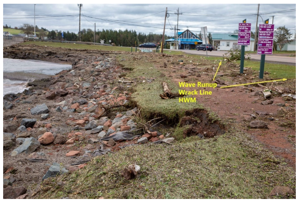
| St. Peters Bay Park N end 2 (Figure A1) | −62.5834 | 46.4184 | 2.97 | 0.04 | Wave runup, Wrack line |
| St. Peters Bay Bridge wrack | −62.5812 | 46.4157 | 3.46 | 0.05 | Wave runup |
| St. Peters Bay Bridge Blowout | −62.5812 | 46.4157 | 3.06 | 0.04 | Wave runup |
| Stanley Bridge Campbellton Rd. Intersection | −63.4620 | 46.4626 | 2.37 | 0.03 | Wave runup |
| Stanley Bridge Wharf | −63.4586 | 46.4628 | 2.48 | 0.03 | Wave runup |
| Summerside Arsenault Fish Mart | −63.7950 | 46.3894 | 0.88 | 0.03 | Surge only |
| Summerside Wharf | −63.7889 | 46.3884 | 0.92 | 0.05 | Stilling well |
| Tignish Shore East end near 210 Cottage Rd | −63.9935 | 46.9413 | 1.70 | 0.04 | Wave height onto cliff evidenced by wrack line. |
| Tignish Shore 14 Cottage Road | −63.9957 | 46.9484 | 0.71 | 0.04 | Surge only |
| Tignish Wharf N side Dune | −63.9948 | 46.9527 | 2.82 | 0.11 | Wave runup onto outer dune |
| Tignish Wharf N side Tide gauge | −63.9983 | 46.9523 | 1.05 | 0.05 | Stilling well |
| Tignish Jude’s Point S Side by COOP | −64.0045 | 46.9516 | 0.77 | 0.05 | Wave Height. Wrack line. Dune erosion |
| West Point Cedar Dunes | −64.3839 | 46.6182 | 0.79 | 0.15 | Wave height. Dune erosion |
| West Point Lighthouse Road | −64.3837 | 46.6194 | 1.16 | 0.05 | Wave height. |
References
- Atlantic Climate Adaptation Solutions Association (ACASA). Coastal Climate Change in Prince Edward Island: Shoreline Protection. 2021. Available online: http://www.gov.pe.ca/photos/original/cle_ShoreProtec.pdf (accessed on 15 October 2021).
- Webster, T. Community High-Water Storm Surge Mapping Network; NS Department of Environment: Halifax, NS, Canada, 2011.
- US Army Corps of Engineers, Dames & Moore. Hurricane Floyd High Water Marks and Inundation Mapping for Eastern North Carolina; FEMA District IV: Atlanta, GA, USA, 2000.
- Fenech, A.; Hedley, N.; Chen, A.; Clark, A. Building a Tool for Visualizing the Impacts of Climate Change on Prince Edward Island, Canada. In Climate Change Adaptation in North America; Filho, W.L., Keenan, J.M., Eds.; Springer Science + Business Media LLC: New York, NY, USA, 2017; pp. 225–238. [Google Scholar]
- Didier, D.; Bernatchez, P.; Boucher-Brossard, G.; Lambert, A.; Fraser, C.; Barnett, R.L.; Van-Wierts, S. Coastal Flood Assessment Based on Field Debris Measurements and Wave Runup Empirical Model. J. Mar. Sci. Eng. 2015, 3, 560–590. [Google Scholar] [CrossRef]
- Duo, E.; Trembanis, A.C.; Dohner, S.; Grottoli, E.; Ciavola, P. Local-scale post-event assessments with GPS and UAV-based quick-response surveys: A pilot case from the Emilia-Romagna (Italy) coast. Nat. Hazards Earth Syst. Sci. 2018, 18, 2969–2989. [Google Scholar] [CrossRef] [Green Version]
- Koenig, T.A.; Bruce, J.L.; O’Connor, J.; McGee, B.D.; Holmes, R.R., Jr.; Hollins, R.; Forbes, B.T.; Kohn, M.S.; Schellekens, M.F.; Martin, Z.W.; et al. Identifying and Preserving High-Water Mark Data; Techniques and Methods; No. 3-A24; United States Geological Survey: Reston, VA, USA, 2016.
- Harris, D.L. Characteristics of the Hurricane Storm Surge; Technical Paper No. 48.; US. Department of Commerce, US. Government Printing Office: Washington, DC, USA, 1963.
- Jardine, D.E.; University of Prince Edward Island, Charlottetown, PE, Canana. Personal communication, 2019.
- LeFaivre, D.; Tessier, B. Unusual Water Level Variations in the St. Lawrence Associated with Hurrican Dorian; Fisheries and Oceans Canada; 19 December 2019; Available online: https://www.qc.dfo-mpo.gc.ca/infoceans/en/infocean/unusual-water-level-variations-st-lawrence-associated-hurricane-dorian (accessed on 9 November 2021).
- Clark, A. A Comparitive Analyis of Conventional and Emerging Methods for Characterizing Coastal Morphology and Change. Master’s Thesis, University of Prince Edward Island, Charlottetown, PE, Canada, 2016. [Google Scholar]
- NRCan. Height Reference System Modernization. 2019. Available online: https://www.nrcan.gc.ca/height-reference-system-modernization/9054#_Canadian_Geodetic_Vertical_1 (accessed on 15 October 2021).
- URS Group, Inc. Final Coastal and Riverine High-Water Mark Collection for Hurricane Katrina in Mississippi, FEMA-1604-DR-MS, Task Orders 413 and 420; Federal Emergency Management Agency (FEMA): Atlanta, GA, USA, 2006.
- Liu, X.; Arnold, S.; Xia, J. A state-of-the-art review on High Water Mark (HWM) determination. Ocean. Coast. Manag. 2014, 102, 178–190. [Google Scholar] [CrossRef]
- Webster, T.; McGuigan, K.; Webster, C. Survey Grade GPS Storm Surge High Water Mapping. Atlantic Climate Adaptation Solutions Association. 2011. Available online: www.atlanticadaptation.ca (accessed on 15 October 2021).
- Wang, X.L.; Feng, Y.; Chan, R.; Isaac, V. Inter-comparison of extra-tropical cyclone activity in nine reanalysis data sets. Atmos. Res. 2016, 181, 133–153. [Google Scholar] [CrossRef] [Green Version]
- Bender, M.A.; Knutson, T.R.; Tuleya, R.E.; Sirutis, J.J.; Vecchi, G.A.; Garner, S.T.; Held, I.M. Modeled Impact of Anthropogenic Warming on the Frequency of Intense Atlantic Hurricanes. In Science; New Series; American Association for the Advancement of Science Stable, 2010; Volume 327, pp. 454–458. Available online: https://www.jstor.org/stable/40508597 (accessed on 15 October 2021).
- Kriebel, D.L.; Geiman, J.D. A Coastal Flood Stage to Define Existing and Future Sea-Level Hazards. J. Coast. Res. 2014, 30, 1017–1024. [Google Scholar] [CrossRef]
- Kruel, S. The Impacts of Sea-Level Rise on Tidal Flooding in Boston, Massachusetts. J. Coast. Res. 2016, 32, 1302–1309. [Google Scholar]


Publisher’s Note: MDPI stays neutral with regard to jurisdictional claims in published maps and institutional affiliations. |
© 2021 by the authors. Licensee MDPI, Basel, Switzerland. This article is an open access article distributed under the terms and conditions of the Creative Commons Attribution (CC BY) license (https://creativecommons.org/licenses/by/4.0/).
Share and Cite
Jardine, D.E.; Wang, X.; Fenech, A.L. Highwater Mark Collection after Post Tropical Storm Dorian and Implications for Prince Edward Island, Canada. Water 2021, 13, 3201. https://doi.org/10.3390/w13223201
Jardine DE, Wang X, Fenech AL. Highwater Mark Collection after Post Tropical Storm Dorian and Implications for Prince Edward Island, Canada. Water. 2021; 13(22):3201. https://doi.org/10.3390/w13223201
Chicago/Turabian StyleJardine, Donald E., Xiuquan Wang, and Adam L. Fenech. 2021. "Highwater Mark Collection after Post Tropical Storm Dorian and Implications for Prince Edward Island, Canada" Water 13, no. 22: 3201. https://doi.org/10.3390/w13223201
APA StyleJardine, D. E., Wang, X., & Fenech, A. L. (2021). Highwater Mark Collection after Post Tropical Storm Dorian and Implications for Prince Edward Island, Canada. Water, 13(22), 3201. https://doi.org/10.3390/w13223201