Article

Climate Change Effects on Fish Passability across a Rock Weir in a Mediterranean River

1
Forest Research Centre (CEF), School of Agriculture, University of Lisbon, Tapada de Ajuda, 1349-017 Lisboa, Portugal
2
Department of Water, Atmosphere and Environment, Institute of Hydrobiology and Aquatic Ecosystem Management, University of Natural Resources and Life Sciences, Vienna, Gregor-Mendel-Straße 33, 1180 Wien, Austria
*
Author to whom correspondence should be addressed.
Water 2021, 13(19), 2758; https://doi.org/10.3390/w13192758
Submission received: 13 September 2021 / Revised: 29 September 2021 / Accepted: 30 September 2021 / Published: 5 October 2021

Abstract

:
Climate change represents a major challenge for the management of native fish communities in Mediterranean rivers, as reductions in discharge may lead to a decrease in passability through small barriers such as weirs, both in temporary and perennial rivers. Through hydraulic modelling, we investigated how discharges from a large hydropower plant in the Tagus River are expected to affect the passability of native freshwater fish species through a rock weir (Pego, Portugal), equipped with a nature-like fish ramp. We considered not only mean daily discharge values retrieved from nearby gauging stations (1991–2005) for our flow datasets, but also predicted discharge values based on climatic projections (RCP) until the end of the century (2071–2100) for the Tagus River. Results showed that a minimum flow of 3 m3 s−1 may be required to ensure the passability of all species through the ramp and that passability was significantly lower in the RCP scenarios than in the historical scenario. This study suggests that climate change may reduce the passability of native fish species in weirs, meaning that the construction of small barriers in rivers should consider the decreases in discharge predicted from global change scenarios for the suitable management of fish populations.

1. Introduction

Rivers have long been among the most endangered ecosystems worldwide, facing multiple threats including the introduction and dispersal of invasive species [1,2], chemical [3] and thermal pollution [4], flow regulation [5,6], longitudinal fragmentation [7] and climate change [8], with the later acting as an enhancer of the previous ones [9,10]. One common consequence of these threats is the gradual loss of suitable habitat, which is particularly worrisome in the case of migratory freshwater fishes, as these migrate along the river (potamodromous) or between the river and sea (diadromous) in different stages of their life cycle to perform critical functions, such as reproduction, feeding and sheltering [11].
Climate change can significantly alter flow regimes [8], leading to the increase of extreme flow events [12,13,14]. In Mediterranean-climate rivers, facing an annual dry season (usually from March to September, being more pronounced from June onwards), increased droughts may further potentiate river fragmentation and loss of suitable habitat due to increased flow intermittency. [15] This issue is particularly relevant as it encompasses the migratory period of potamodromous and diadromous fish species; therefore, interfering directly with their migrations and recruitment, and lately affecting the sustainability of their populations [16].
Fish movement and migration may be further limited by the presence of small barriers such as weirs, which are generally far more numerous than large dams and clearly represent significant barriers to fish migration [17,18]. These instream structures change the depth and velocity patterns, creating vertical drops that change the hydrodynamics of aquatic systems and may prevent the movement of migratory fish to spawning, feeding and refuge areas [19], and thus their permeability should be assessed for a proper management of these populations [20,21]. The permeability of a weir to fish passage (i.e., passability) will depend not only on its structural properties (e.g., length, slope, substrate), but also on the hydraulic conditions (e.g., flow regime), within a given time and area, providing “flow windows” for fish to pass [22,23]. The passability of a given fish species and life history stage through weirs will also depend on key hydraulic variables, namely flow velocity and water depth [23], that structure habitat suitability [24].
The potential combined effects of weir passability along with the climate change-driven increased flow intermittency of rivers is seldom investigated and deserves greater attention. Despite some uncertainty attributed to flow predictions due to different modelling assumptions, studies so far have suggested that in the Mediterranean region, mean monthly flows and annual flow rates are expected to decrease with climate change [25,26]. On the other hand, extreme flow conditions (high flow and low flow magnitudes, and duration) are expected to increase in Mediterranean rivers [27], potentially reducing the suitable habitat area for fish species to be able to overcome barriers.
The use of modelling approaches to determine measures of habitat suitability, such as habitat suitability indexes (HSI), can provide a relative measure of fish passability, based on the available area for fish in specific stages of their life cycle, considering specific flow requirements determined for each species [28]. Habitat suitability curves (HSC) can be developed for this purpose, but often require detailed data at a microhabitat scale, which are typically scarce in large rivers [29]. Recent studies have recommended the use of mesohabitat data (ranging from 10 to 100 m) as the relevant spatial scale of habitat use by fish [30,31] and the use of expert opinion to build HSC based on previous literature and expert knowledge on the species, lowering both the research effort and need for empirical data on habitat use and preference of fishes [32].
For modelling habitat suitability, 2D hydraulic models have the advantage of being more robust and predicting hydraulic conditions more accurately over 1D models, provided that sufficient and good resolution bed topography data is collected, and that model calibration is performed [33,34,35]. Relative measures of fish passability can be estimated based on the suitable habitat and hydraulic conditions (such as water depth and flow velocity) of small instream obstacles over time and space [24,36,37].
The main goal of this study is to evaluate the passability of the low-head Pego weir, in the Tagus River, Central Portugal, to the different migratory fish species, in relation to historical (1991–2005) and future flow conditions based on two global warming scenarios (RCP 4.5 and RCP 8.5), following the reports of ISI-MIP: Inter-Sectoral Impact Model Intercomparison Project [38]. As current projections for the Mediterranean region suggest a decrease in river discharge in the following decades, it is expected that fish passability will be lower under scenarios of low flow conditions, due to the reduction of the submerged area of the weir. Specifically, we expect passability for all species to be lower under global climate change scenarios.

2. Materials and Methods
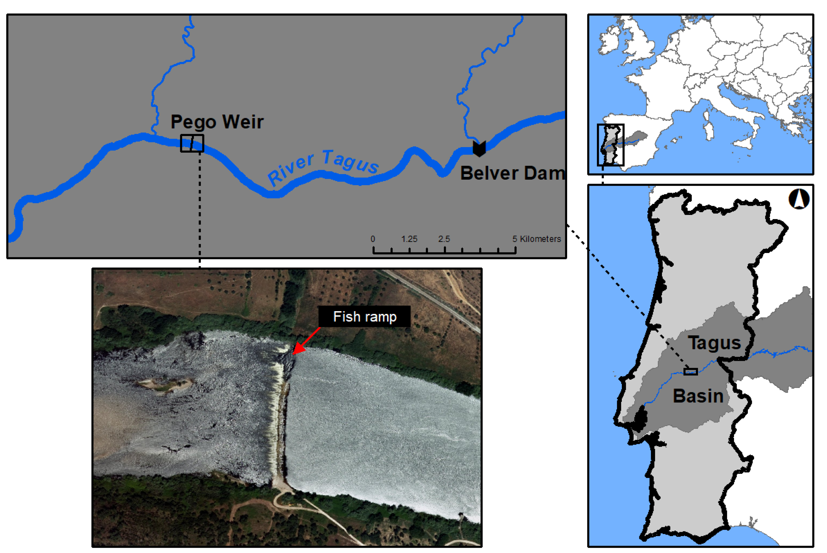
2.1. Study Area

This study was conducted in the Pego weir, located in the Tagus River, close to the municipality of Abrantes, Portugal (Figure 1). The Tagus River is the longest river in the Iberian Peninsula (1110 km), with a drainage area of 80,630 km2 and a hydrological regime typical of a Mediterranean-climate river, with lower flow values in summer months and higher values in winter [39]. Data collected from gauging stations shows that it has a relatively high flow variation coefficient (72.15%), contrasting with a relatively low annual coefficient of variation (7.29%), within the period ranging from 1991 to 2005 [40].
Within this river basin, the Pego weir, a 250 m wide low-head ramped weir, was built between 1992 and 1995, to allow water collection to cool down the turbines from a nearby coal thermal power plant, which has recently ceased activity (Figure 1). The weir features a fish ramp located close to the river’s right bank, which is approximately 20 m long and 4 m wide, at an elevation of 23 m, with a longitudinal slope of 2.5% (Figure S1). Both the weir and the fish ramp present a substrate dominated by rocks and boulders. This structure was built to ensure the passability of the local native fish species. The closest upstream barrier is the Belver dam, one of the main large hydropower plants in the Tagus River basin, located 12 km upstream of the Pego weir, with an installed power of 80.7 MW and a storage capacity of 7.5 hm3. Flow data provided by the Portuguese Environmental Agency and local gauging stations reveal that turbined flows do not exceed 800 m3 s−1 [40]. The Belver dam is a run-of-the-river hydropower plant, with low water retention and a reduced thermal stratification in the water column, with no significant variations in water temperature downstream expected.

2.2. Flow Data and Topographic Survey

Flow data was retrieved from the Portuguese national network on water resources (SNIRH), which aggregates data on discharge and other water quality related parameters collected from gauging and meteorological stations nationwide [40]. Mean daily discharge values were retrieved from the available data recorded in the nearby Belver gauging station (station code: 17J/01A), from 1st January 1991 to 31st December 2005, in line with the historical period considered in the Intergovernmental Panel on Climate Change [38] reports on climate projections (1986–2005). Missing values (approximately 15%) were estimated by linear regression (R2 = 0.934) from mean daily flows recorded in the Almourol gauging station (station code: 17G/02A), approximately 28 km downstream from the study area. It should be noted that there are no tributaries between the Pego weir and the Belver dam, and that inflows in the Pego weir are strongly associated with the turbined flows in Belver [41].
For the climate projections, two global warming scenarios (RCP 4.5 and RCP 8.5) were used, following the reports of ISI-MIP: Inter-Sectoral Impact Model Intercomparison Project [38]. The considered scenarios stand for “Representative Concentration Pathways” (RCP), describing general trajectories of greenhouse gases (GHG) emissions, concentrations and land use emissions until the end of the century (2100), according to specific radiative forcing values, namely 4.5 and 8.5 W m−2. RCP 4.5 is described as a more conservative and moderate scenario, while RCP 8.5 is the extreme one. Particularly for the Tagus River basin, decreases in average monthly flows of 30% and 60% in the late century (2071–2100) were previously estimated following RCP 4.5 and RCP 8.5 trajectories, respectively, when integrating reservoirs and water management processes in the hydrological models for river discharge at Almourol, with a strong decrease in hydropower production under both future climate scenarios being expected [26]. These projections consider the regional warming trends through statistical downscaling and bias correction, as an alternative to regional climatic models, with the goal of preserving warming trends [42]. Focusing on low flows (Q90), as these are expected to be more impacted by climate change, we considered two hydrologic scenarios: one with a reduction of 30% on mean daily discharges (RCP 4.5) and another with a 60% (RCP 8.5) reduction, both until the end of the century (2071–2100), regarding the original discharge dataset retrieved from the gauging stations.

2.3. Suitability Curves and Habitat Modelling

Fish passability was determined by modelling habitat suitability for the native freshwater fish community using River2D, a two-dimensional depth averaged model which combines the hydraulic conditions close to the weir with HSC for each fish species [43]. The key hydraulic variables for which HSC were developed were water depth (above the weir) and flow velocity, similarly to previous studies assessing fish passability in weirs [44,45]. The boundary conditions considered in this model were the inflow section (in m3 s−1) and the water level at the outflow section (in meters), making use of a rating curve of the cross-section that was computed with an acoustic Doppler current profiler (ADCP), that took measurements in the cross-section during several different discharges. Model calibration was done by comparing the modeled values for flow velocity and water depth with the values measured in the field. Field measurements took place at the end of the dry season (September) under different flow conditions. The River2D model ran with a spatial mesh of 2 × 2 m in general, refined to 0.5 × 0.5 m in the weir area, similarly to one used for the topographic survey of the 2D model.
The fish community is composed by a multitude of species with different migratory traits, including: (i) anadromous—Allis shad (Alosa alosa), twaite shad (Alosa fallax) and sea lamprey (Petromyzon marinus), (ii) catadromous—European eel (Anguilla anguilla) and thlinlip grey mullet (Chelon ramada) and (iii) potamodromous species—Iberian barbel (Luciobarbus bocagei). Due to the lack of detailed data on HSC for these species, an expert judgment approach [46,47] following a literature review (Table 1) was used to build the species HSC, based on flow velocity and water depth (Figures S2 and S3 in Supplementary Material). Such approaches based on the application of literature or expert opinion-based data, performed in similar conditions—i.e., when empirical data is scarce and difficult to gather (cost limited, lack of time or reference conditions, species with low detectability such as the diadromous ones)—were applied elsewhere [46,47,48,49,50]. A previous assessment of the river topography allowed for the characterization of the hydraulic conditions (flow velocity and water depth) and for the calibration of the River2D model [41].
To evaluate passability and determine the minimum flow required for each species to pass the weir, a stepwise approach was followed, modelling in steps of 1 m3 s−1 and assessing the response of the habitat suitability index (HSI) throughout the weir and particularly in the fish ramp. This index was calculated as a product of the separate suitability indices: flow velocity index (VSI), water depth index (DSI) and channel index (CSI, which considers the substrate, dominated by rocks and boulders, constant and evenly distributed within the study area and thus with no significant influence in habitat suitability, assuming a constant value in the formula): HSI = VSI × DSI × CSI [43]. Mean HSI values from each scenario were adjusted to a sigmoid function [68], allowing the estimation of HSI for each discharge value of the datasets by interpolation.

2.4. Data Analyses

Quantile distribution of the mean daily discharges from the historical data were analyzed to determine the low flow conditions (Q90, corresponding to the 10th percentile) in the two hydrologic scenarios considered (30% in RCP 4.5 and 60% in RCP 8.5). The comparison of mean daily discharge between each scenario was achieved using the non-parametric Kruskal–Wallis test due to non-normally distributed data (Shapiro–Wilk). A Kruskal–Wallis test (followed by a post hoc Dunn test for pairwise differences) was also performed to investigate differences in HSI between flow scenarios (for each species) and between species (in each scenario). Analyses were conducted in R, version 4.1.0 [69] and Statistica, version 10 [70].

3. Results

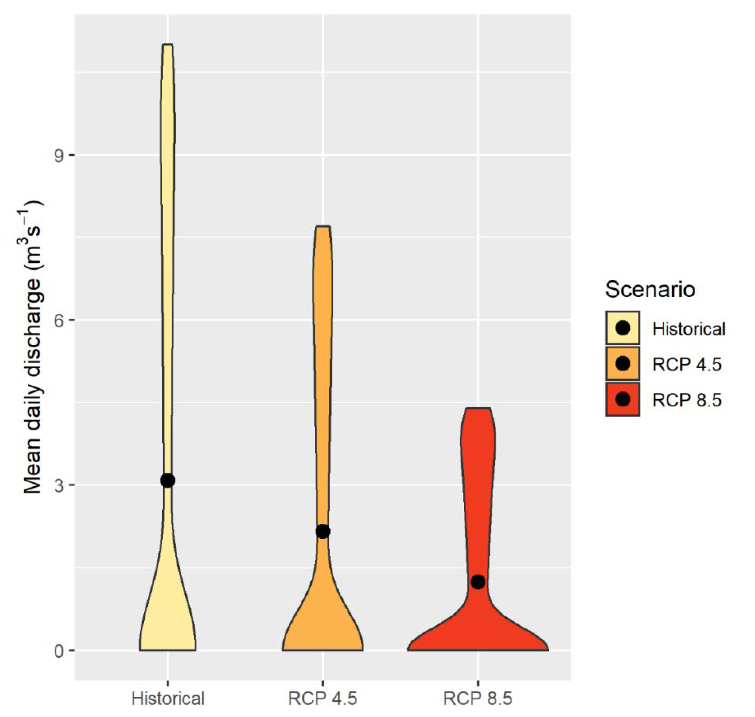
3.1. Flow under Future Climate Change Scenarios

Low flow conditions for the historical period (1991–2005) included discharges from 0 to 11.0 m3 s−1, with null values being recorded in 316 days, mostly between March and September (71%), which is usually considered the dry season in the Mediterranean climate. Mean daily discharge was significantly different between the three scenarios (χ2 = 28.232, df = 2, p < 0.001), being lowest in RCP 8.5 (mean value: 1.2 m3 s−1), intermediate in RCP 4.5 (2.1 m3 s−1) and highest in the historical (3.1 m3 s−1) scenario (Figure 2).

3.2. Minimum Flow Assessment

River2D modelling revealed that under low flow conditions, more than half of the weir was emersed, with the percentage of submersed area varying from 21% (for inflows of 1 m3 s−1) to 42% (for inflows of 11 m3 s−1), which was reflected in a generally low passability close to the ramp for all species. The suitable area allowing fish passage was only observed at a minimum discharge of 3 m3 s−1 (when the fish ramp became submersed), regardless of the species (Figure 3).

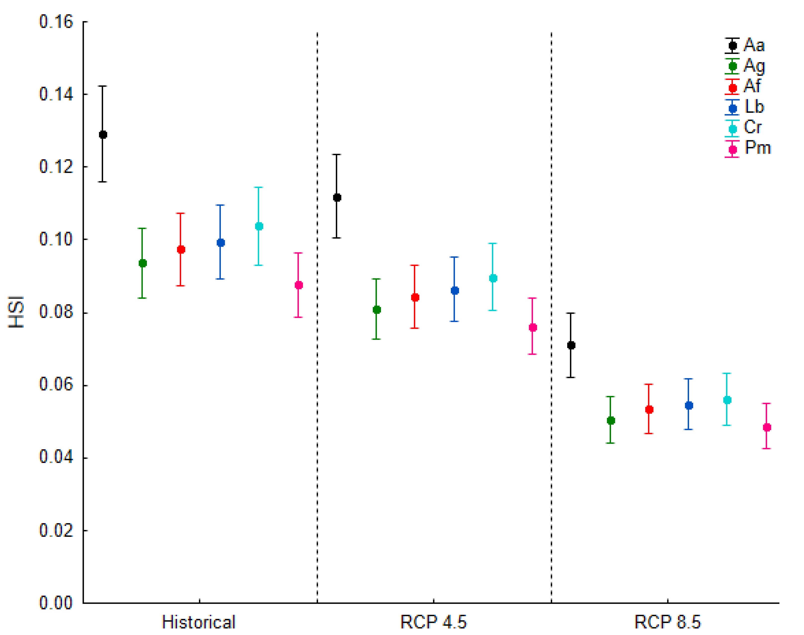
3.3. Passability across Different Climate Change Scenarios

Habitat suitability under low flow conditions was significantly different among species (χ2 = 38.752, df = 5, p < 0.001). Overall, A. alosa had the highest mean HSI (ranging from 0.08 ± 0.11 in RCP 8.5 and 0.13 ± 0.16 in the historical scenario), while P. marinus scored the lowest (mean HSI: 0.06 ± 0.07 in RCP 8.5 and 0.09 ± 0.11 in historical). Both species had significantly different mean HSI when compared to the remaining species (Dunn post hoc test): A. anguilla (mean HSI: 0.05 ± 0.10 RCP 8.5 and 0.09 ± 0.08 in historical), A. fallax (mean HSI: 0.05 ± 0.08 RCP 8.5 and 0.10 ± 0.12 historical), L. bocagei (mean HSI: 0.05 ± 0.08 RCP 8.5 and 0.10 ± 0.12) and C. ramada (mean HSI: 0.06 ± 0.09 RCP 8.5 and 0.10 ± 0.13 historical). Significant differences for HSI between the three scenarios were also observed within each species (χ2 = 58.794, df = 2, p < 0.001) and for pairwise comparisons, with all species attaining higher scores in the historical scenario (Figure 4).

4. Discussion

Changes in hydrology under climate change can lead to shifts in fish habitat suitability and distribution in rivers [71]. For migratory fish species, which shift from different habitats (spawning, feeding, refuge) during their life cycle, this habitat loss is particularly worrisome, particularly in the presence of barriers to fish movement, making it essential to assess how habitat may change in the advent of future flow regimes [16]. However, quantifying the impact of climate change in natural populations is challenging, as different effects are expected depending on the climate model trajectories that are assumed [72], the temporal range (mid or late century) and the effect of climate change on the multiple stressors already acting [73].
In this study, we built flow datasets for the different climatic scenarios—RCP 4.5 and RCP 8.5—by assuming the predicted changes in monthly discharge described by Lobanova et al. [26] for the Tagus River, with reductions of 30 and 60%, respectively, until 2100. Passability for all species occurred at a minimum flow of 3 m3 s−1, and the frequency of null flows and flows lower than the required threshold for fish passage increased in both RCP 4.5 and RCP 8.5 scenarios. This result is particularly relevant as the increase in “zero-flow” day frequency has been reported as a severe threat to hydrological connectivity and species persistence in rivers [74]. By adding the cumulative effect of a small barrier (weir), this means that the decrease in the occurrence of suitable flows for fish populations close to the Pego weir, over the next decades, may lead to an overall decrease in the weir passability to the different fish species.
Passability was found to be significantly lower in the RCP 4.5 and RCP 8.5 scenarios relatively to the historical dataset (1991–2005). Habitat modelling using River2D also revealed that under low flow conditions, passability only occurred in the area covered by the fish ramp, close the right bank. A previous assessment of the Pego weir showed that inflows of at least 30 m3 s−1 are required to allow fish passage across the remaining area of the weir, with all species being able to pass the weir if it was submerged [41]. This further enhances the importance of this fishway for upstream migration, as mean daily discharge will tend to decrease in future climates [8,26], while droughts are expected to increase in frequency and intensity [14,74].
While 2D assessment of fish passability was only performed for low flow conditions, it revealed differences between the different species, which can be explained by their different swimming capacities. Overall, the two clupeid species, A. alosa and A. fallax, had the highest passabilities in all scenarios, attaining the first and second highest HSI values, respectively. Previous studies on nature-like fishways (such as rock ramps) reported higher passability for Alosa species compared to the other ones present in the fish community using the same fishway [75]. Contrastingly, the sea lamprey P. marinus had the lowest passability, even though nature-like fishways are suggested as more adequate for allowing lamprey passage when compared to technical fishways such as pool and Denil fishways [76]. Emphasis on improving attraction efficiency under low conditions, considering the swimming performance and behavior of the different species composing the migratory fish community, should be put into future fishway adjustments (e.g., boulder arrangement: [77]).
The passability of the Pego weir was modelled for different climate scenarios, considering the key hydraulic variables—flow velocity and water depth—that are known to highly influence fish passage in this type of instream structures. As the difficulty in gathering appropriate data for developing HSC would reveal cost and effort-intensive for a large river such as the Tagus River, an expert judgement approach was followed [32,36,49,50]. Coupled with an extensive characterization of the hydraulic conditions in the study area, a relative measure of passability based on the habitat suitability of each species was obtained, proving that this approach may be a useful alternative to empirical studies for fish population management purposes.
Successful fish passage across an instream obstacle is a more complex phenomenon other than depending solely on flow velocity and water depth above the weir. The willingness to negotiate a barrier is also driven by internal factors—the physiological condition, such as fatigue level, migratory phase, age, and body size [78]—as well as individual predisposition to move upstream, and other external factors not accounted on the present study, such as water temperature [79]. Though our modelling approach enabled us to estimate fish passability for different migratory species across a small weir in a large river, considering the critical hydraulic variables, future validation with empirical studies, such as fish telemetry tracking, is essential if we want to effectively use such tools in river conservation and management plans [80].

5. Conclusions

To conclude, this study provided evidence that under low flow conditions, the passability of migratory fish species in the Pego weir is generally low and only occurring through the fish ramp. Results suggest that under future flow regimes, the permeability of the weir to fish passage is likely to further decrease for all species. This highlights the need to account for future impacts of altered flow regimes driven by climate change on fish populations, considering current and future climatic models and flow requirements for each species when modelling habitat suitability and fish passability. Moreover, it is crucial to adapt conditions for obstacle transposition, namely by improving attraction efficiency close to the ramp, followed by monitoring surveys of fishway efficiency. The ongoing transition of fossil fuels to renewable energy occurring in Portugal (and in other countries worldwide), is expected to lead to an adjustment of coal thermal plants (to coal-fired plants using charcoal) or in some cases to a complete shutdown, making the barriers that were built to accommodate its activity obsolete and thus potential targets for removal. This would allow for a more efficient re-establishment of longitudinal connectivity for all fish species.

Supplementary Materials

The following are available online at https://www.mdpi.com/article/10.3390/w13192758/s1, Figure S1: Fish ramp (20 m long, 4 m wide, 23 m elevation, 2.5% longitudinal slope), at the right margin of the Tagus River, incorporated in the Pego weir. Picture retrieved following the study by Ferreira et al.; Figure S2: Suitability curves for the flow velocity at the ramp weir for each species, based on the literature review; Figure S3: Suitability curves for the water depth above the weir for each species, based on the literature review.

Author Contributions

Conceptualization, J.M.S. and M.T.F.; methodology, D.M., J.M.S. and R.R.; software, D.M. and R.R.; formal analysis, D.M., J.M.S. and R.R. and S.S; investigation, D.M., J.M.S. and R.R.; writing—original draft preparation, D.M.; writing—review and editing, J.M.S., M.T.F., R.R. and S.S.; supervision, J.M.S., M.T.F. and S.S.; project administration, M.T.F.; funding acquisition, M.T.F. All authors have read and agreed to the published version of the manuscript.

Funding

The study was funded by PEGOP under the protocol “Passability of the Pego weir by fish species”. The funders had no role in the design of the study; in the collection, analyses, or interpretation of data; in the writing of the manuscript, or in the decision to publish the results.

Institutional Review Board Statement

Not applicable.

Informed Consent Statement

Not applicable.

Acknowledgments

Daniel Mameri was supported by a Ph.D. grant from the FLUVIO—River Restoration and Management program funded by FCT (PD/BD/142885/2018). Rui Rivaes is supported by a research contract under the project RIVEAL—Riparian forest Values and Ecosystem services in uncertain freshwater futures and Altered Landscapes (PTDC/CTA-AMB/29790/2017; www.riveal.pt, accessed on 1 March 2021). José Maria Santos benefited from an Investigator contract (IF/00020/2015) also funded by FCT. The Forest Research Centre (CEF) is a research unit funded by Fundação para a Ciência e a Tecnologia I.P. (FCT), Portugal (UIDB/00239/2020). Finally, the authors would like to thank three anonymous reviewers for their comments that helped improving the manuscript.

Conflicts of Interest

The authors declare no conflict of interest.

References

  1. Bruno, D.; Belmar, O.; Maire, A.; Morel, A.; Dumont, B.; Datry, T. Structural and functional responses of invertebrate communities to climate change and flow regulation in alpine catchments. Glob. Chang. Biol. 2019, 25, 1612–1628. [Google Scholar] [CrossRef] [Green Version]
  2. Capinha, C.; Larson, E.R.; Tricarico, E.; Olden, J.D.; Gherardi, F. Effects of Climate Change, Invasive Species, and Disease on the Distribution of Native European Crayfishes. Conserv. Biol. 2013, 27, 731–740. [Google Scholar] [CrossRef] [PubMed]
  3. Green, F.B.; East, A.G.; Salice, C.J. Will temperature increases associated with climate change potentiate toxicity of environmentally relevant concentrations of chloride on larval green frogs (Lithobates clamitans)? Sci. Total. Environ. 2019, 682, 282–290. [Google Scholar] [CrossRef]
  4. Miara, A.; Vörösmarty, C.J.; Macknick, J.E.; Tidwell, V.C.; Fekete, B.; Corsi, F.; Newmark, R. Thermal pollution impacts on rivers and power supply in the Mississippi River watershed. Environ. Res. Lett. 2018, 13, 034033. [Google Scholar] [CrossRef]
  5. Aristi, I.; Arroita, M.; Larrañaga, A.; Ponsatí, L.; Sabater, S.; von Schiller, D.; Elosegi, A.; Acuña, V. Flow regulation by dams affects ecosystem metabolism in Mediterranean rivers. Freshw. Biol. 2014, 59, 1816–1829. [Google Scholar] [CrossRef]
  6. Schmutz, S.; Bakken, T.H.; Friedrich, T.; Greimel, F.; Harby, A.; Jungwirth, M.; Melcher, A.; Unfer, G.; Zeiringer, B. Response of Fish Communities to Hydrological and Morphological Alterations in Hydropeaking Rivers of Austria. River Res. Appl. 2014, 31, 919–930. [Google Scholar] [CrossRef] [Green Version]
  7. Fuller, M.R.; Doyle, M.W.; Strayer, D.L. Causes and consequences of habitat fragmentation in river networks. Ann. New York Acad. Sci. 2015, 1355, 31–51. [Google Scholar] [CrossRef]
  8. van Vliet, M.T.H.; Franssen, W.H.P.; Yearsley, J.R.; Ludwig, F.; Haddeland, I.; Lettenmaier, D.P.; Kabat, P. Global river discharge and water temperature under climate change. Glob. Environ. Chang. 2013, 23, 450–464. [Google Scholar] [CrossRef]
  9. Dyer, F.; ElSawah, S.; Croke, B.; Griffiths, R.; Harrison, E.; Lucena-Moya, P.; Jakeman, A. The effects of climate change on ecologically-relevant flow regime and water quality attributes. Stoch. Environ. Res. Risk Assess. 2013, 28, 67–82. [Google Scholar] [CrossRef] [Green Version]
  10. Palmer, M.A.; Lettenmaier, D.P.; Poff, N.L.; Postel, S.L.; Richter, B.; Warner, R. Climate Change and River Ecosystems: Protection and Adaptation Options. Environ. Manag. 2009, 44, 1053–1068. [Google Scholar] [CrossRef]
  11. Plesiński, K.; Bylak, A.; Radecki-Pawlik, A.; Mikołajczyk, T.; Kukuła, K. Possibilities of fish passage through the block ramp: Model-based estimation of permeability. Sci. Total. Environ. 2018, 631–632, 1201–1211. [Google Scholar] [CrossRef] [PubMed]
  12. Huntjens, P.; Pahl-Wostl, C.; Grin, J. Climate change adaptation in European river basins. Reg. Environ. Chang. 2010, 10, 263–284. [Google Scholar] [CrossRef] [Green Version]
  13. Lechner, A.; Keckeis, H.; Humphries, P. Patterns and processes in the drift of early developmental stages of fish in rivers: A review. Rev. Fish. Biol. Fish. 2016, 26, 471–489. [Google Scholar] [CrossRef] [Green Version]
  14. Lennox, R.J.; Crook, D.A.; Moyle, P.B.; Struthers, D.P.; Cooke, S.J. Toward a better understanding of freshwater fish responses to an increasingly drought-stricken world. Rev. Fish. Biol. Fish. 2019, 29, 71–92. [Google Scholar] [CrossRef]
  15. Cid, N.; Bonada, N.; Carlson, S.; Grantham, T.; Gasith, A.; Resh, V. High Variability Is a Defining Component of Mediterranean-Climate Rivers and Their Biota. Water 2017, 9, 52. [Google Scholar] [CrossRef] [Green Version]
  16. García-Vega, A.; Sanz-Ronda, F.J.; Fernandes Celestino, L.; Makrakis, S.; Leunda, P.M. Potamodromous brown trout movements in the North of the Iberian Peninsula: Modelling past, present and future based on continuous fishway monitoring. Sci. Total. Environ. 2018, 640–641, 1521–1536. [Google Scholar] [CrossRef]
  17. Bae, M.-J.; Merciai, R.; Benejam, L.; Sabater, S.; García-Berthou, E. Small Weirs, Big Effects: Disruption of Water Temperature Regimes with Hydrological Alteration in a Mediterranean Stream. River Res. Appl. 2015, 32, 309–319. [Google Scholar] [CrossRef]
  18. Belletti, B.; Garcia de Leaniz, C.; Jones, J.; Bizzi, S.; Börger, L.; Segura, G.; Castelletti, A.; van de Bund, W.; Aarestrup, K.; Barry, J.; et al. More than one million barriers fragment Europe’s rivers. Nature 2020, 588, 436–441. [Google Scholar] [CrossRef] [PubMed]
  19. Ordeix, M.; Pou-Rovira, Q.; Sellarès, N.; Munné, A.; Bardina, M.; Casamitjana, A. Fish pass assessment in the rivers of Catalonia (NE Iberian Peninsula). A case study of weirs associated with hydropower plants and gauging stations. Limnetica 2011, 29, 405–426. [Google Scholar]
  20. Amaral, S.D.; Branco, P.; da Silva, A.T.; Katopodis, C.; Viseu, T.; Ferreira, M.T.; Pinheiro, A.N.; Santos, J.M. Upstream passage of potamodromous cyprinids over small weirs: The influence of key-hydraulic parameters. J. Ecohydraulics 2016, 1, 79–89. [Google Scholar] [CrossRef]
  21. Cortes, R.; Peredo, A.; Terêncio, D.; Sanches Fernandes, L.; Moura, J.; Jesus, J.; Magalhães, M.; Ferreira, P.; Pacheco, F. Undamming the Douro River Catchment: A Stepwise Approach for Prioritizing Dam Removal. Water 2019, 11, 693. [Google Scholar] [CrossRef] [Green Version]
  22. Reiser, D.W.; Huang, C.-M.; Beck, S.; Gagner, M.; Jeanes, E. Defining Flow Windows for Upstream Passage of Adult Anadromous Salmonids at Cascades and Falls. Trans. Am. Fish. Soc. 2016, 135, 668–679. [Google Scholar] [CrossRef]
  23. Shaw, E.A.; Lange, E.; Shucksmith, J.D.; Lerner, D.N. Importance of partial barriers and temporal variation in flow when modelling connectivity in fragmented river systems. Ecol. Eng. 2016, 91, 515–528. [Google Scholar] [CrossRef] [Green Version]
  24. Santos, J.M.; Rivaes, R.; Boavida, I.; Branco, P. Structural microhabitat use by endemic cyprinids in a Mediterranean-type river: Implications for restoration practices. Aquat. Conserv. Mar. Freshw. Ecosyst. 2017, 28, 26–36. [Google Scholar] [CrossRef]
  25. Fonseca, A.R.; Santos, J.A. Predicting hydrologic flows under climate change: The Tâmega Basin as an analog for the Mediterranean region. Sci. Total. Environ. 2017, 668, 1013–1024. [Google Scholar] [CrossRef] [PubMed]
  26. Lobanova, A.; Koch, H.; Liersch, S.; Hattermann, F.F.; Krysanova, V. Impacts of changing climate on the hydrology and hydropower production of the Tagus River basin. Hydrol. Process. 2016, 30, 5039–5052. [Google Scholar] [CrossRef]
  27. Sellami, H.; Benabdallah, S.; La Jeunesse, I.; Vanclooster, M. Quantifying hydrological responses of small Mediterranean catchments under climate change projections. Sci. Total. Environ. 2016, 543, 924–936. [Google Scholar] [CrossRef] [PubMed]
  28. Boavida, I.; Jesus, J.B.; Pereira, V.; Santos, C.; Lopes, M.; Cortes, R.M.V. Fulfilling spawning flow requirements for potamodromous cyprinids in a restored river segment. Sci. Total. Environ. 2018, 635, 567–575. [Google Scholar] [CrossRef]
  29. Best, J. Anthropogenic stresses on the world’s big rivers. Nat. Geosci. 2018, 12, 7–21. [Google Scholar] [CrossRef]
  30. Schwartz, J. Use of Ecohydraulic-Based Mesohabitat Classification and Fish Species Traits for Stream Restoration Design. Water 2016, 8, 520. [Google Scholar] [CrossRef] [Green Version]
  31. Spurgeon, J.; Pegg, M.; Parasiewicz, P.; Rogers, J. River-Wide Habitat Availability for Fish Habitat Guilds: Implications for In-Stream Flow Protection. Water 2019, 11, 1132. [Google Scholar] [CrossRef] [Green Version]
  32. Wegscheider, B.; Linnansaari, T.; Ndong, M.; Haralampides, K.; St-Hilaire, A.; Schneider, M.; Curry, R.A. Fish habitat modelling in large rivers: Combining expert opinion and hydrodynamic modellingto inform river management. J. Ecohydraulics 2021, 1–19. [Google Scholar] [CrossRef]
  33. Jowett, I.G.; Duncan, M.J. Effectiveness of 1D and 2D hydraulic models for instream habitat analysis in a braided river. Ecol. Eng. 2012, 48, 92–100. [Google Scholar] [CrossRef]
  34. Baki, A.B.M.; Zhu, D.Z.; Rajaratnam, N. Flow Simulation in a Rock-Ramp Fish Pass. J. Hydraul. Eng. 2016, 142, 04016031. [Google Scholar] [CrossRef]
  35. Tran, T.D.; Chorda, J.; Laurens, P.; Cassan, L. Modelling nature-like fishway flow around unsubmerged obstacles using a 2D shallow water model. Environ. Fluid Mech. 2015, 16, 413–428. [Google Scholar] [CrossRef] [Green Version]
  36. Boavida, I.; Santos, J.M.; Pinheiro, A.N.; Ferreira, M.T. Fish habitat availability simulations using different morphological variables. Limnetica 2011, 30, 393–404. [Google Scholar] [CrossRef]
  37. Rivaes, R.; Boavida, I.; Santos, J.M.; Pinheiro, A.N.; Ferreira, T. Importance of considering riparian vegetation requirements for the long-term efficiency of environmental flows in aquatic microhabitats. Hydrol. Earth Syst. Sci. 2017, 21, 5763–5780. [Google Scholar] [CrossRef] [Green Version]
  38. Warszawski, L.; Frieler, K.; Huber, V.; Piontek, F.; Serdeczny, O.; Schewe, J. The Inter-Sectoral Impact Model Intercomparison Project (ISI–MIP): Project framework. Proc. Natl. Acad. Sci. USA 2013, 111, 3228–3232. [Google Scholar] [CrossRef] [Green Version]
  39. Fazelpoor, K.; Martínez-Fernández, V.; García de Jalón, D. Exploring the hydromorphological response to human pressure in Tagus River (1946–2014) by complementary diagnosis. CATENA 2021, 198, 105052. [Google Scholar] [CrossRef]
  40. APA–Agência Portuguesa do Ambiente, I.P. SNIRH–Sistema Nacional de Informação em Recursos Hídricos; Ministério do Ambiente e Transição Energética: Lisboa, Portugal, 2021. Available online: https://snirh.apambiente.pt/ (accessed on 1 March 2021).
  41. Ferreira, M.T.; Santos, J.M.; Rivaes, R. Avaliação da Transponibilidade do Travessão da Central Termoelétrica do Pego Para Espécies Piscícolas. Relatório Final; Instituto Superior de Agronomia: Lisboa, Portugal; Universidade de Lisboa: Lisboa, Portugal, 2014. [Google Scholar]
  42. Hempel, S.; Frieler, K.; Warszawski, L.; Schewe, J.; Piontek, F. A trend-preserving bias correction–the ISI-MIP approach. Earth Syst. Dyn. 2013, 4, 219–236. [Google Scholar] [CrossRef] [Green Version]
  43. Steffler, P.; Blackburn, J. River2D, Two-Dimensional Depth Averaged Model. of River Hydrodynamics and Fish. In Habitat, Introduction to Depth Averaged Modeling and User’s Manual; University of Alberta: Edmonton, AB, Canada, 2002. [Google Scholar]
  44. Amaral, S.D.; Quaresma, A.L.; Branco, P.; Romão, F.; Katopodis, C.; Ferreira, M.T.; Pinheiro, A.N.; Santos, J.M. Assessment of Retrofitted Ramped Weirs to Improve Passage of Potamodromous Fish. Water 2019, 11, 2441. [Google Scholar] [CrossRef] [Green Version]
  45. Solà, C.; Ordeix, M.; Pou-Rovira, Q.; Sellarès, N.; Queralt, A.; Bardina, M.; Casamitjana, A.; Munné, A. Longitudinal connectivity in hydromorphological quality assessments of rivers. The ICF index: A river connectivity index and its application to Catalan rivers. Limnetica 2011, 30, 273–292. [Google Scholar] [CrossRef]
  46. Adamczyk, M.; Parasiewicz, P.; Vezza, P.; Prus, P.; De Cesare, G. Empirical Validation of MesoHABSIM Models Developed with Different Habitat Suitability Criteria for Bullhead Cottus gobio L. as an Indicator Species. Water 2019, 11, 726. [Google Scholar] [CrossRef] [Green Version]
  47. Parasiewicz, P.; Prus, P.; Theodoropoulos, C.; Alfredsen, K.; Adamczyk, M.; Comoglio, C.; Vezza, P. Environmental Flows Determination and Monitoring with Hydraulic Habitat Models—Pushing the Boundaries of Habitat Models Application. Water 2019, 11, 1950. [Google Scholar] [CrossRef] [Green Version]
  48. Boavida, I.; Dias, V.; Ferreira, M.T.; Santos, J.M. Univariate functions versus fuzzy logic: Implications for fish habitat modeling. Ecol. Eng. 2014, 71, 533–538. [Google Scholar] [CrossRef]
  49. Mouton, A.M.; De Baets, B.; Goethals, P.L.M. Data-driven fuzzy habitat models: Impact of performance criteria and opportunities for ecohydraulics. In Ecohydraulics: An Integrated Approach; Maddock, I., Harby, A., Kemp, P., Wood, P., Eds.; John Wiley & Sons Ltd: Chichester, UK, 2013; pp. 93–107. [Google Scholar]
  50. Parasiewicz, P.; Rogers, J.N.; Vezza, P.; Gortazar, J.; Seager, T.; Pegg, M.; Wiśniewolski, W.; Comoglio, C. Applications of the MesoHABSIM simulation model. In Ecohydraulics: An Integrated Approach; Maddock, I., Harby, A., Kemp, P., Wood, P., Eds.; John Wiley & Sons Ltd: Chichester, UK, 2013; pp. 109–125. [Google Scholar]
  51. Belaud, A.; Carette, A.; Cassou-Leins, F.; Cassou-Leins, J.J. Choix des sites de fraie par la grand alose (Alosa alosa L.) en Moyenne Garonne. Bull. Français de La Pêche et de La Piscic. 2001, 362–363, 869–880. [Google Scholar] [CrossRef] [Green Version]
  52. Caswell, P.A.; Aprahamian, M.W. Use of River Habitat Survey to determine the spawning habitat characteristics of twaite shad (Alosa fallax fallax). Bull. Français de La Pêche et de La Piscic. 2001, 362–363, 919–929. [Google Scholar] [CrossRef]
  53. Maitland, P.S. Ecology of the river, brook and sea lamprey. In Conserving Natura 2000 Rivers Ecology Series No. 5; English Nature: Peterborough, UK, 2003. [Google Scholar]
  54. Pereira, E.; Quintella, B.R.; Mateus, C.S.; Alexandre, C.M.; Belo, A.F.; Telhado, A.; Quadrado, M.F.; Almeida, P.R. Performance of a Vertical-Slot Fish Pass for the Sea Lamprey Petromyzon marinus L. and Habitat Recolonization. River Res. Appl. 2016, 33, 16–26. [Google Scholar] [CrossRef]
  55. Bracken, F.S.A.; Rooney, S.M.; Kelly-Quinn, M.; King, J.J.; Carlsson, J. Identifying spawning sites and other critical habitat in lotic systems using eDNA “snapshots”: A case study using the sea lamprey Petromyzon marinus L. Ecol. Evol. 2018, 9, 553–567. [Google Scholar] [CrossRef] [Green Version]
  56. Mitchell, C.P. Swimming performances of some native freshwater fishes. New Zealand J. Mar. Freshw. Res. 1989, 23, 181–187. [Google Scholar] [CrossRef]
  57. Vagner, M.; Lefrançois, C.; Ferrari, R.S.; Satta, A.; Domenici, P. The effect of acute hypoxia on swimming stamina at optimal swimming speed in flathead grey mullet Mugil cephalus. Mar. Biol. 2008, 155, 183–190. [Google Scholar] [CrossRef]
  58. Lamouroux, N.; Capra, H.; Pouilly, M.; Souchon, Y. Fish habitat preferences in large streams of southern France. Freshw. Biol. 1999, 42, 673–687. [Google Scholar] [CrossRef]
  59. Arai, T.; Kotake, A.; McCarthy, T.K. Habitat use by the European eel Anguilla anguilla in Irish waters. Estuar. Coast. Shelf Sci. 2006, 67, 569–578. [Google Scholar] [CrossRef]
  60. Daverat, F.; Limburg, K.; Thibault, I.; Shiao, J.; Dodson, J.; Caron, F.; Tzeng, W.; Iizuka, Y.; Wickström, H. Phenotypic plasticity of habitat use by three temperate eel species, Anguilla anguilla, A. japonica and A. rostrata. Mar. Ecol. Prog. Ser. 2006, 308, 231–241. [Google Scholar] [CrossRef]
  61. Riley, W.D.; Walker, A.M.; Bendall, B.; Ives, M.J. Movements of the European eel (Anguilla anguilla) in a chalk stream. Ecol. Freshw. Fish. 2011, 20, 628–635. [Google Scholar] [CrossRef]
  62. Johnson, J.H.; Nack, C.C. Habitat use of American eel (Anguilla rostrata) in a tributary of the Hudson River, New York. J. Appl. Ichthyol. 2013, 29, 1073–1079. [Google Scholar] [CrossRef]
  63. Alexandre, C.M.; Quintella, B.R.; Ferreira, A.F.; Romão, F.A.; Almeida, P.R. Swimming performance and ecomorphology of the Iberian barbel Luciobarbus bocagei (Steindachner, 1864) on permanent and temporary rivers. Ecol. Freshw. Fish 2013, 23, 244–258. [Google Scholar] [CrossRef]
  64. Mateus, C.S.; Quintella, B.R.; Almeida, P.R. The critical swimming speed of Iberian barbel Barbus bocagei in relation to size and sex. J. Fish Biol. 2008, 73, 1783–1789. [Google Scholar] [CrossRef]
  65. Santos, J.M.; Silva, A.; Katopodis, C.; Pinheiro, P.; Pinheiro, A.; Bochechas, J.; Ferreira, M.T. Ecohydraulics of pool-type fishways: Getting past the barriers. Ecol. Eng. 2012, 48, 38–50. [Google Scholar] [CrossRef]
  66. Sanz-Ronda, F.J.; Ruiz-Legazpi, J.; Bravo-Córdoba, F.J.; Makrakis, S.; Castro-Santos, T. Sprinting performance of two Iberian fish: Luciobarbus bocagei and Pseudochondrostoma duriense in an open channel flume. Ecol. Eng. 2015, 83, 61–70. [Google Scholar] [CrossRef]
  67. Sanz-Ronda, F.J.; Bravo-Córdoba, F.J.; Fuentes-Pérez, J.F.; Castro-Santos, T. Ascent ability of brown trout, Salmo trutta, and two Iberian cyprinids–Iberian barbel, Luciobarbus bocagei, and northern straight-mouth nase, Pseudochondrostoma duriense–in a vertical slot fishway. Knowl. Manag. Aquat. Ecosyst. 2016, 417, 10. [Google Scholar] [CrossRef] [Green Version]
  68. Theuerkauf, S.J.; Lipcius, R.N. Quantitative Validation of a Habitat Suitability Index for Oyster Restoration. Front. Mar. Sci. 2016, 3. [Google Scholar] [CrossRef] [Green Version]
  69. R: A Language and Environment for Statistical Computing, R Foundation for Statistical Computing, version 4.1.0; R Core Team: Vienna, Austria, 2021.
  70. Statistica (Data Analysis Software System); Version 10; StatSoft, Inc.: Hamburg, Germany, 2011.
  71. Segurado, P.; Branco, P.; Jauch, E.; Neves, R.; Ferreira, M.T. Sensitivity of river fishes to climate change: The role of hydrological stressors on habitat range shifts. Sci. Total. Environ. 2016, 562, 435–445. [Google Scholar] [CrossRef] [PubMed]
  72. Arnell, N.W.; Gosling, S.N. The impacts of climate change on river flow regimes at the global scale. J. Hydrol. 2013, 486, 351–364. [Google Scholar] [CrossRef]
  73. Branco, P.; Santos, J.M.; Amaral, S.; Romão, F.; Pinheiro, A.N.; Ferreira, M.T. Potamodromous fish movements under multiple stressors: Connectivity reduction and oxygen depletion. Sci. Total. Environ. 2016, 572, 520–525. [Google Scholar] [CrossRef]
  74. Jaeger, K.L.; Olden, J.D.; Pelland, N.A. Climate change poised to threaten hydrologic connectivity and endemic fishes in dryland streams. Proc. Natl. Acad. Sci. USA 2014, 111, 13894–13899. [Google Scholar] [CrossRef] [Green Version]
  75. Raabe, J.K.; Hightower, J.E.; Ellis, T.A.; Facendola, J.J. Evaluation of Fish Passage at a Nature-Like Rock Ramp Fishway on a Large Coastal River. Trans. Am. Fish. Soc. 2019, 148, 798–816. [Google Scholar] [CrossRef]
  76. Foulds, W.L.; Lucas, M.C. Extreme inefficiency of two conventional, technical fishways used by European river lamprey (Lampetra fluviatilis). Ecol. Eng. 2013, 58, 423–433. [Google Scholar] [CrossRef] [Green Version]
  77. Muraoka, K.; Nakanishi, S.; Kayaba, Y. Boulder arrangement on a rocky ramp fishway based on the swimming behavior of fish. Limnologica 2017, 62, 188–193. [Google Scholar] [CrossRef]
  78. Castro-Santos, T.; Sanz-Ronda, F.J.; Ruiz-Legazpi, J. Breaking the speed limit–comparative sprinting performance of brook trout (Salvelinus fontinalis) and brown trout (Salmo trutta). Can. J. Fish. Aquat. Sci. 2013, 70, 280–293. [Google Scholar] [CrossRef]
  79. Kemp, P.S.; Russon, I.J.; Vowles, A.S.; Lucas, M.C. The influence of discharge and temperature on the ability of upstream migrant adult river lamprey (Lampetra fluviatilis) to pass experimental overshot and undershot weirs. River Res. Appl. 2011, 27, 488–498. [Google Scholar] [CrossRef]
  80. Samia, Y.; Lutscher, F.; Hastings, A. Connectivity, passability and heterogeneity interact to determine fish population persistence in river networks. J. R. Soc. Interface 2015, 12, 20150435. [Google Scholar] [CrossRef] [PubMed] [Green Version]
Figure 1. Pego weir in the Tagus River, approximately 12 km downstream of the Belver dam.
Water 13 02758 g001
Figure 2. Density distribution of mean daily discharge (m3 s−1) for the historical, RCP 4.5 and RCP 8.5 scenarios, predicted for the Pego weir, based on the climate change projections for the Tagus River.
Water 13 02758 g002
Figure 3. River2D output habitat suitability index for P. marinus (which displayed generally lower HSI values among the species present) in the Pego weir (left) and specifically at the fish ramp (right), for an inflow of 3 m3 s−1. Colored scales are presented for each case (HSI varying from 0-blue to 1-red, water depth from 0 to 5.32 m).
Water 13 02758 g003
Figure 4. Habitat suitability index (HSI) in each scenario for each species: Alosa alosa (Aa), Anguilla anguilla (Ag), Alosa fallax (Af), Luciobarbus bocagei (Lb), Chelon ramada (Cl), Petromyzon marinus (Pm). Mean values and 95% confidence intervals are given by dots and whiskers, respectively.
Water 13 02758 g004
Table 1. Literature considered for the construction of the species habitat suitability curves (HSC), based on key variables that structure fish passability at low-head ramped weirs [45]: flow velocity at the ramp weir and water depth above the weirs.
Common NameScientific NameReferences
Allis shadAlosa alosa[51,52]
Twait shadAlosa fallax[51,53]
Sea lampreyPetromizon marinus[51,54,55,56]
Thinlip grey mulletChelon ramada[51,57,58]
European eelAnguilla anguilla[51,58,59,60,61,62]
Iberian barbelLuciobarbus bocagei[51,63,64,65,66,67]
Publisher’s Note: MDPI stays neutral with regard to jurisdictional claims in published maps and institutional affiliations.

