
Method for Operating Drainage Pump Stations Considering Downstream Water Level and Reduction in Urban River Flooding


Abstract
:1. Introduction
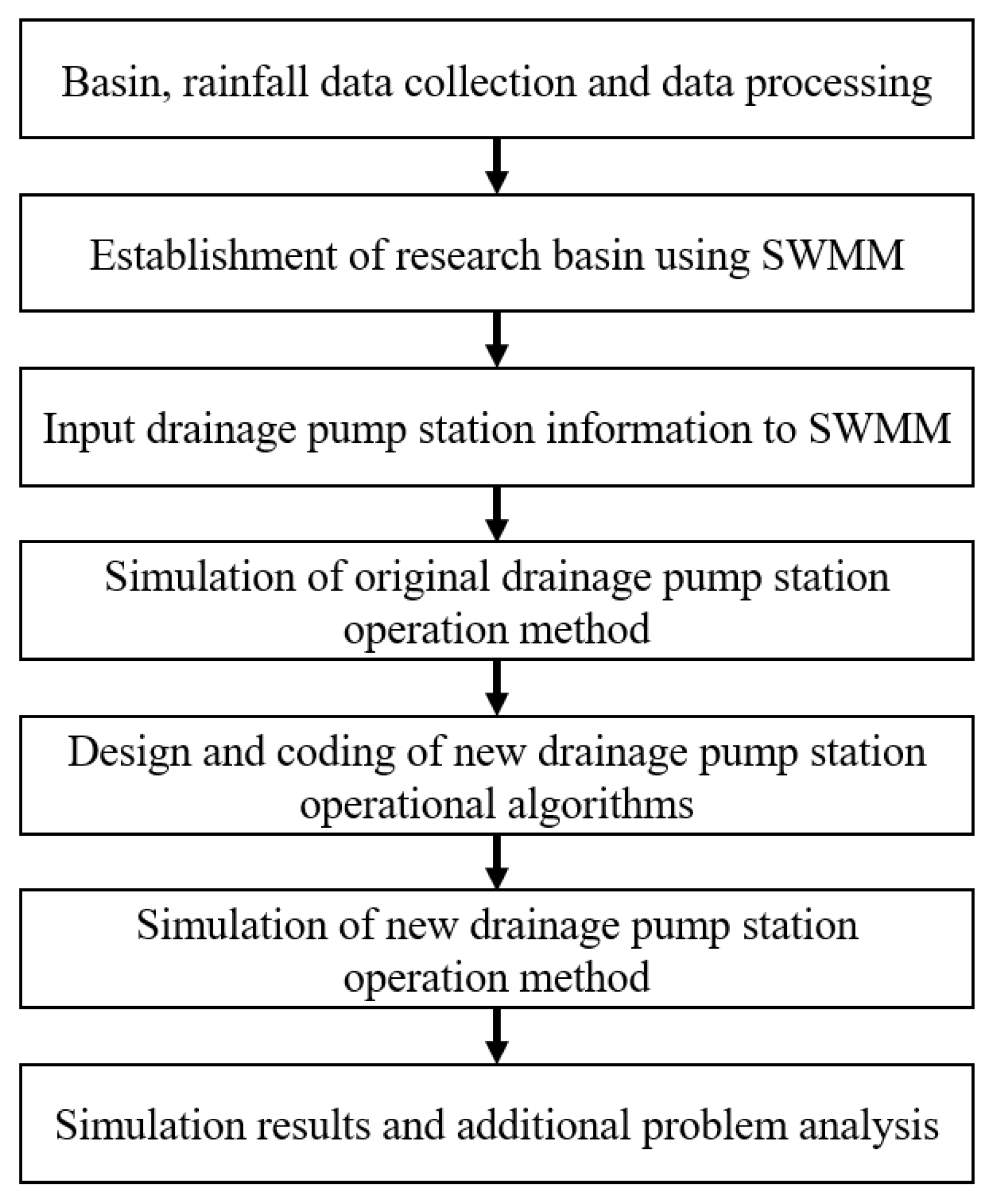
2. Methods
2.1. Outline
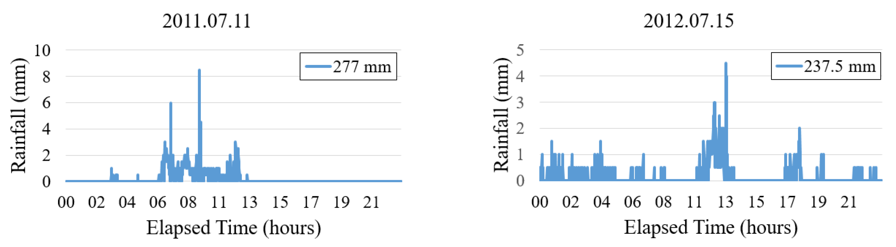
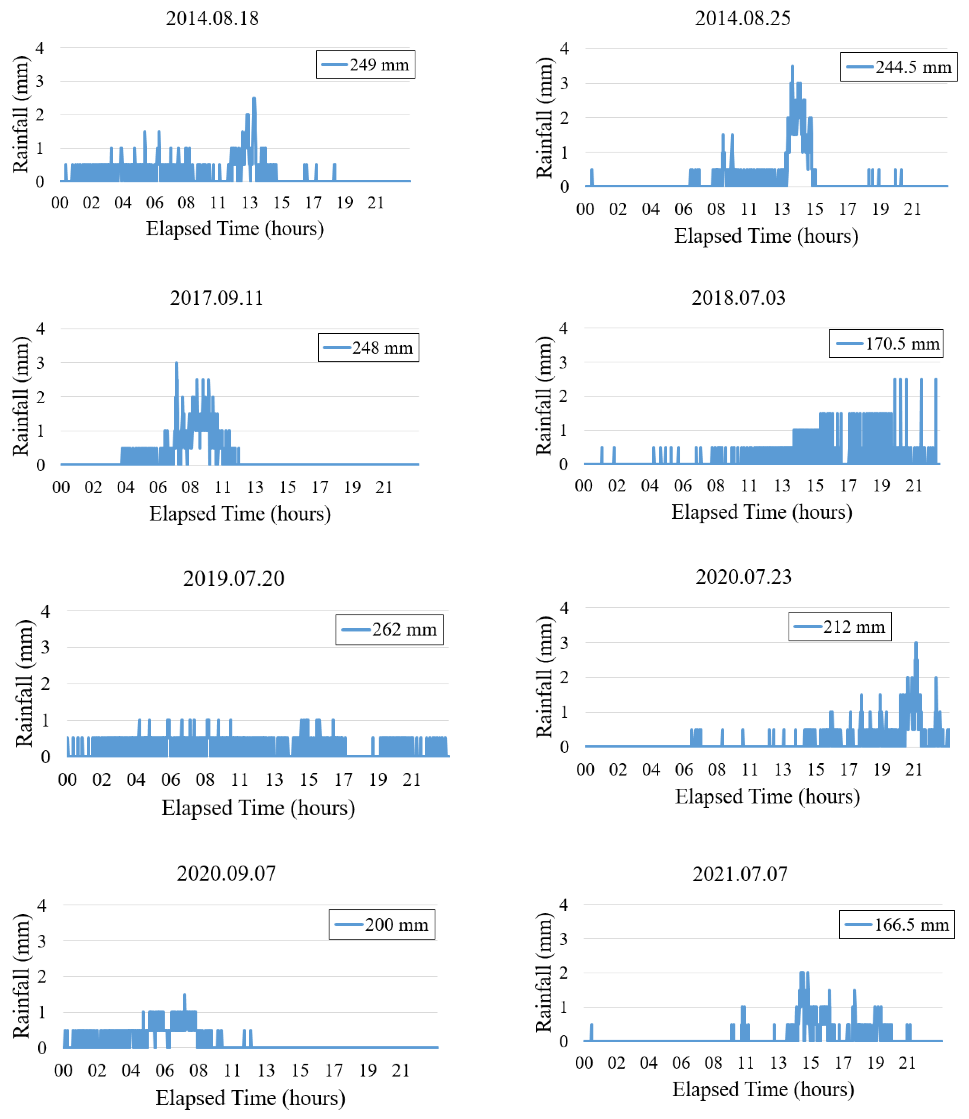
2.2. Rainfall Data
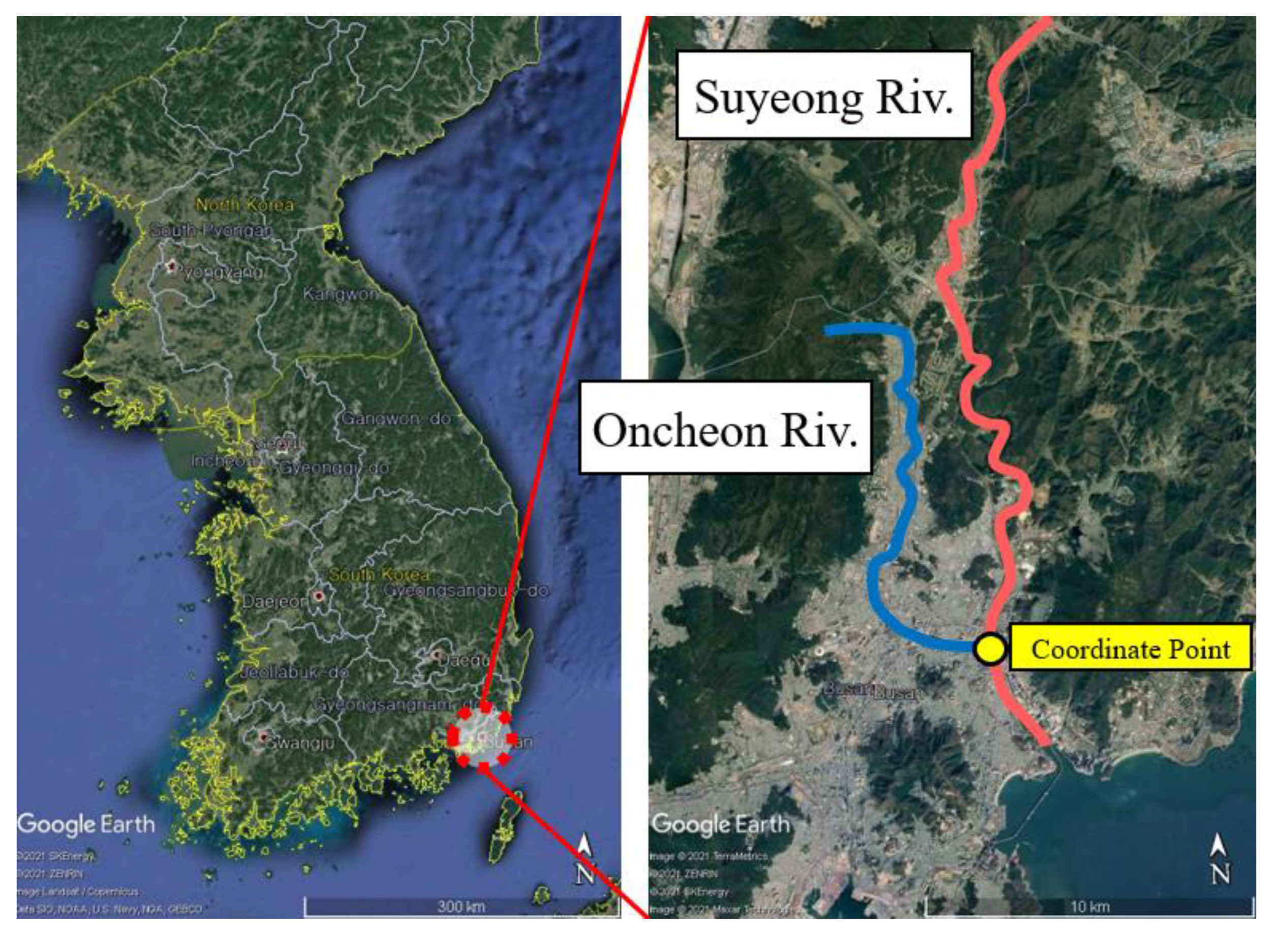
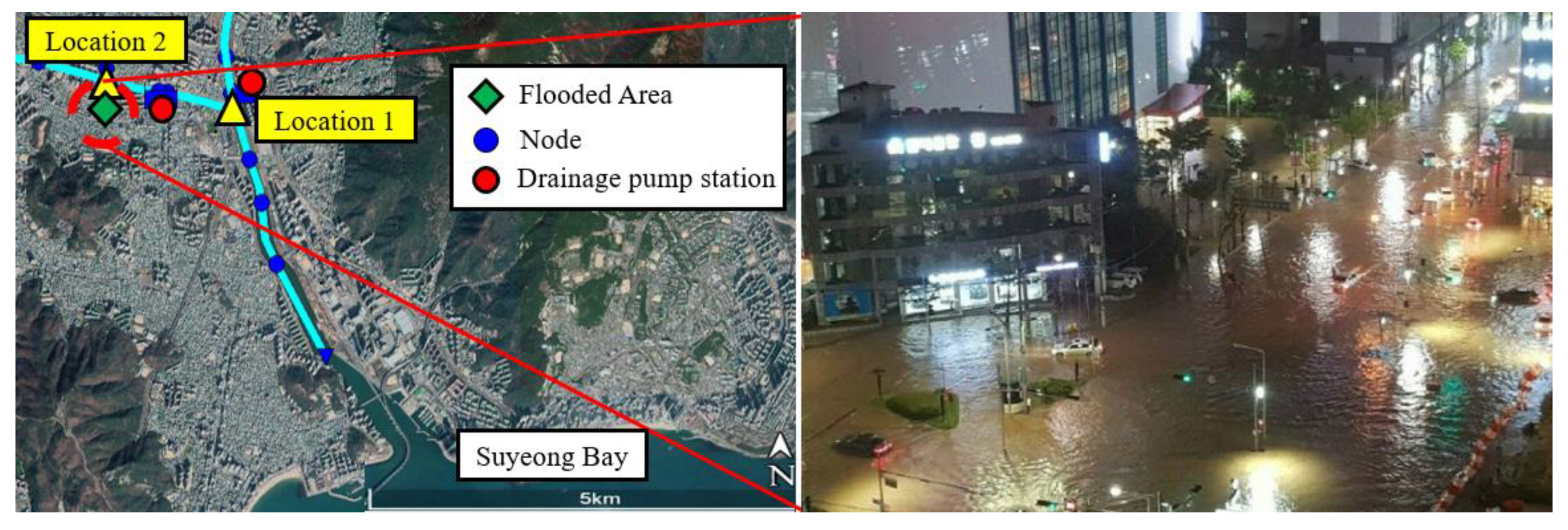
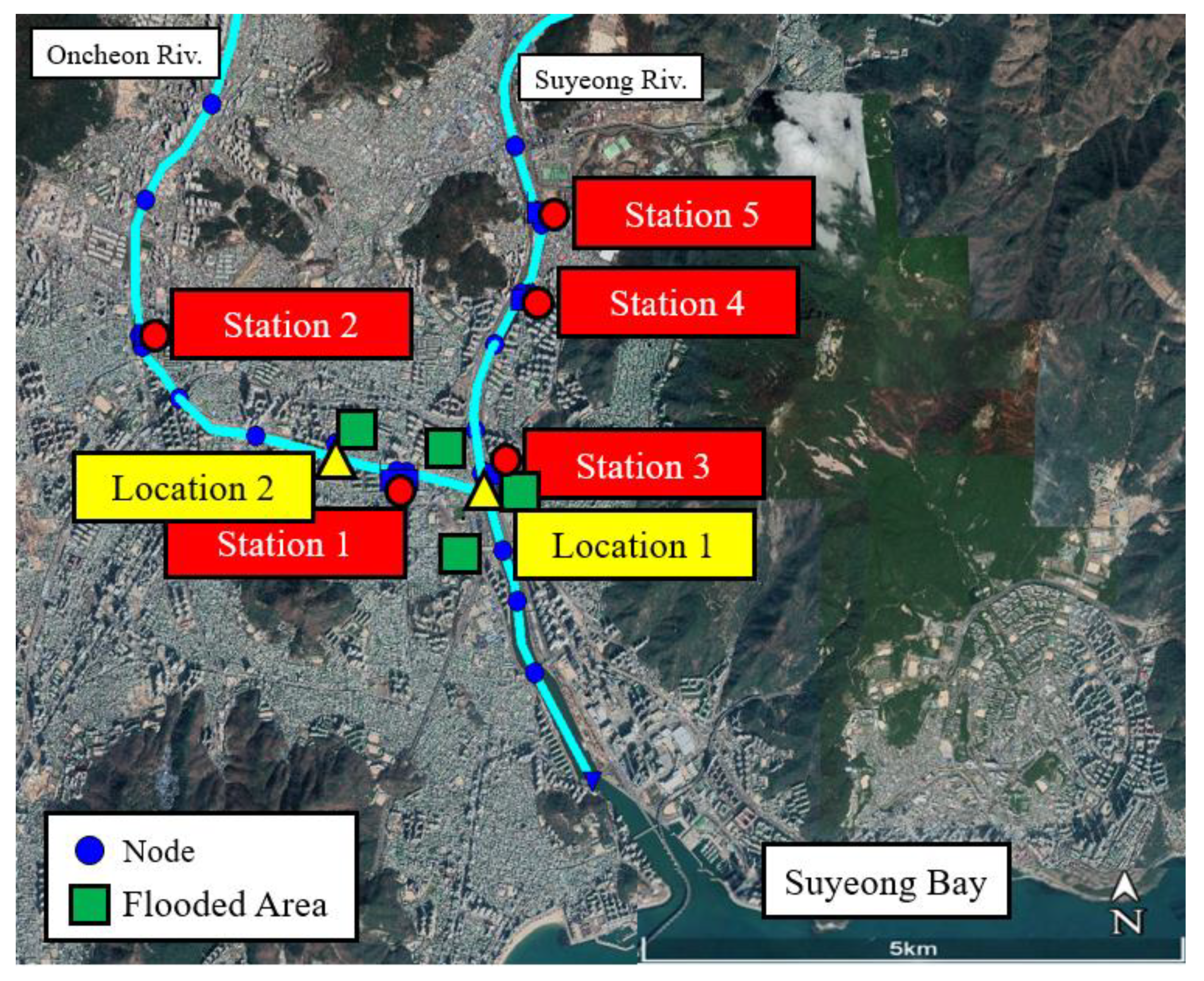
2.3. Research Basin Composition
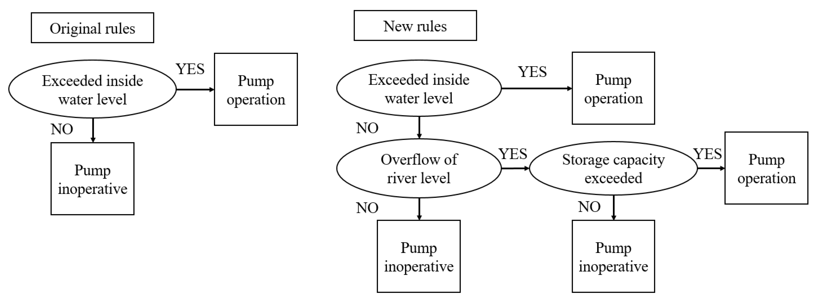
2.4. Algorithm Construction
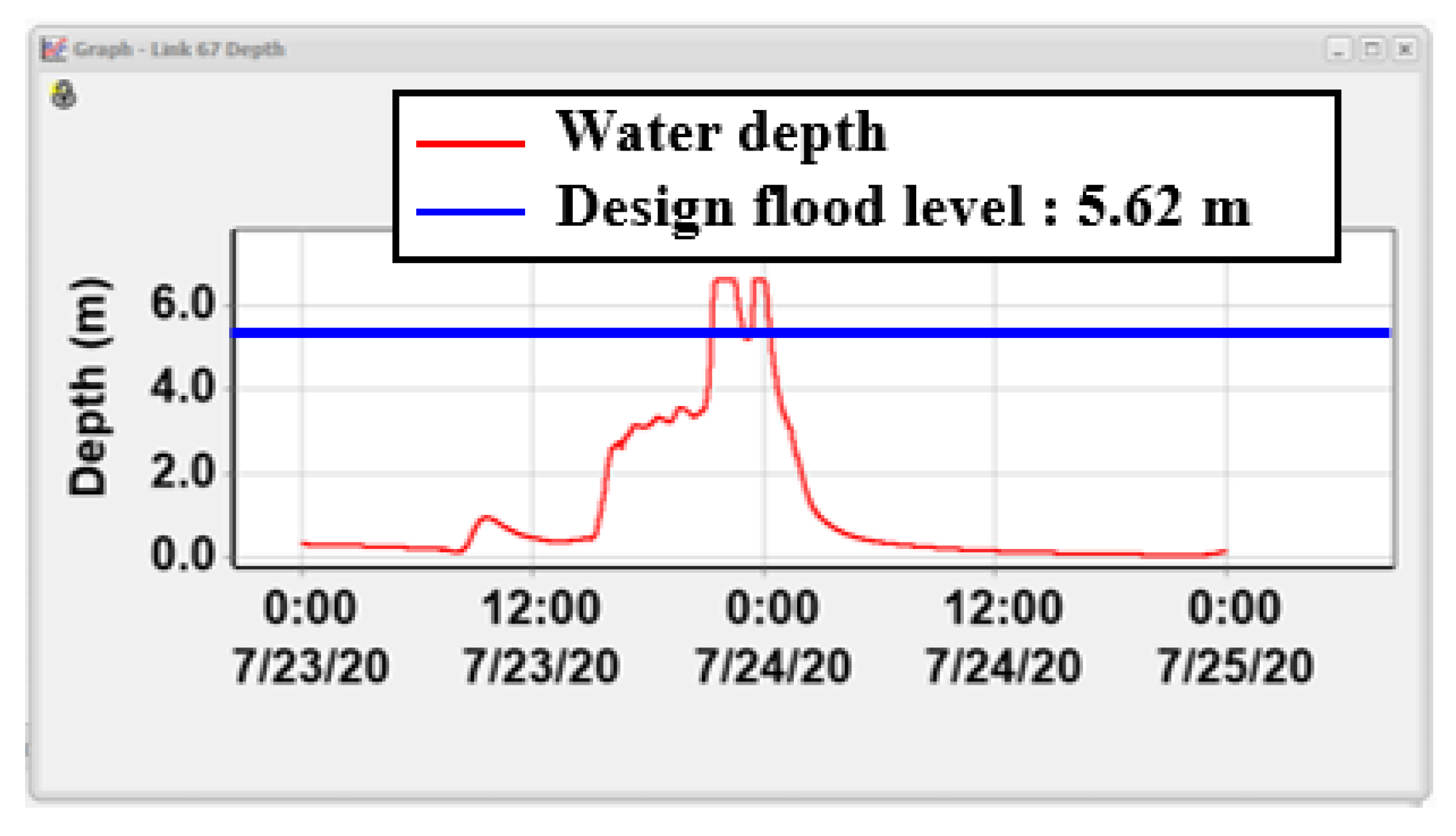
2.5. Validation of the Model
3. Results
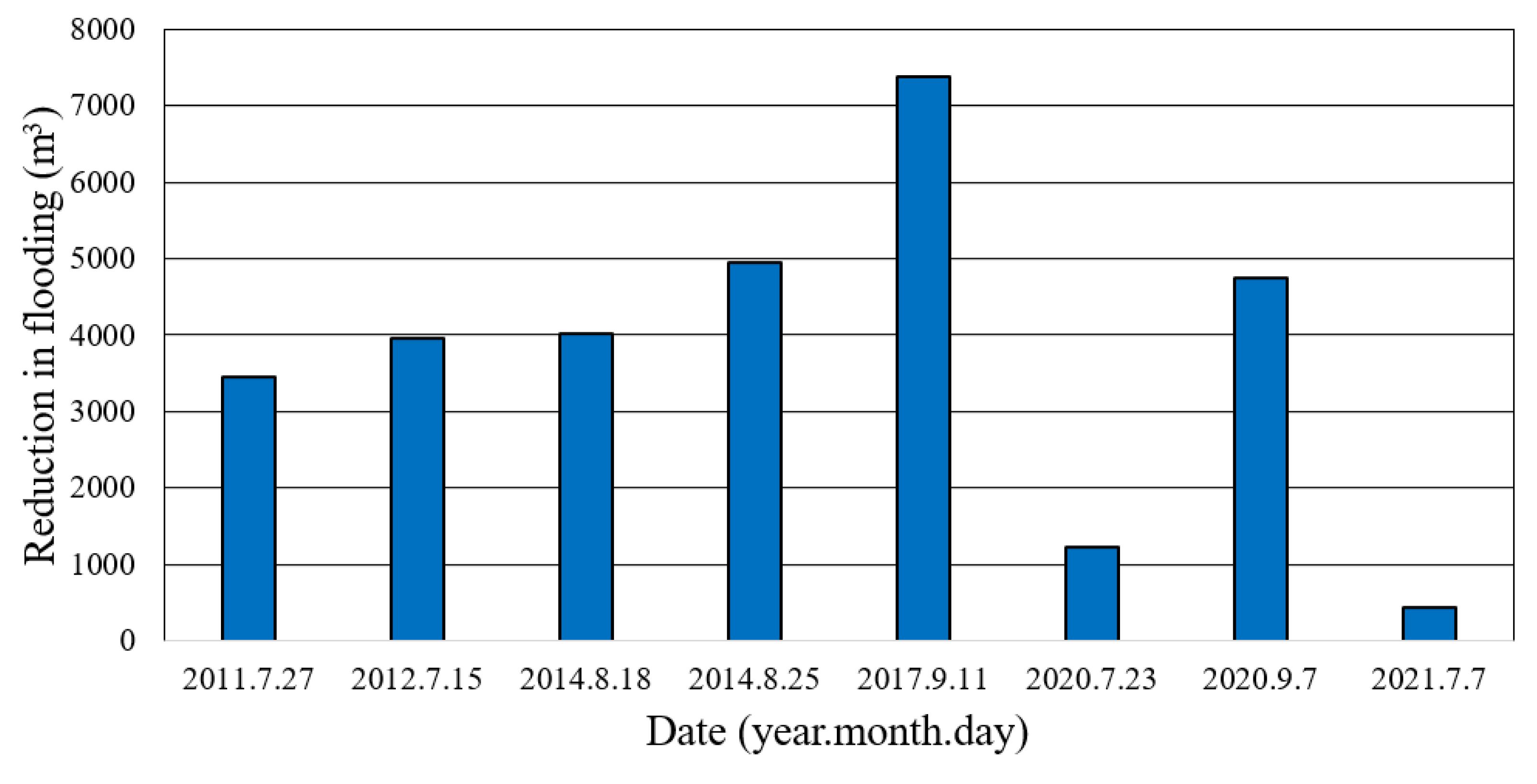
3.1. Effectiveness of New Methods
- The impermeable area of the Oncheon River is approximately 49%, and most of the area surrounds the stream; hence, rainwater was directly discharged into the stream.
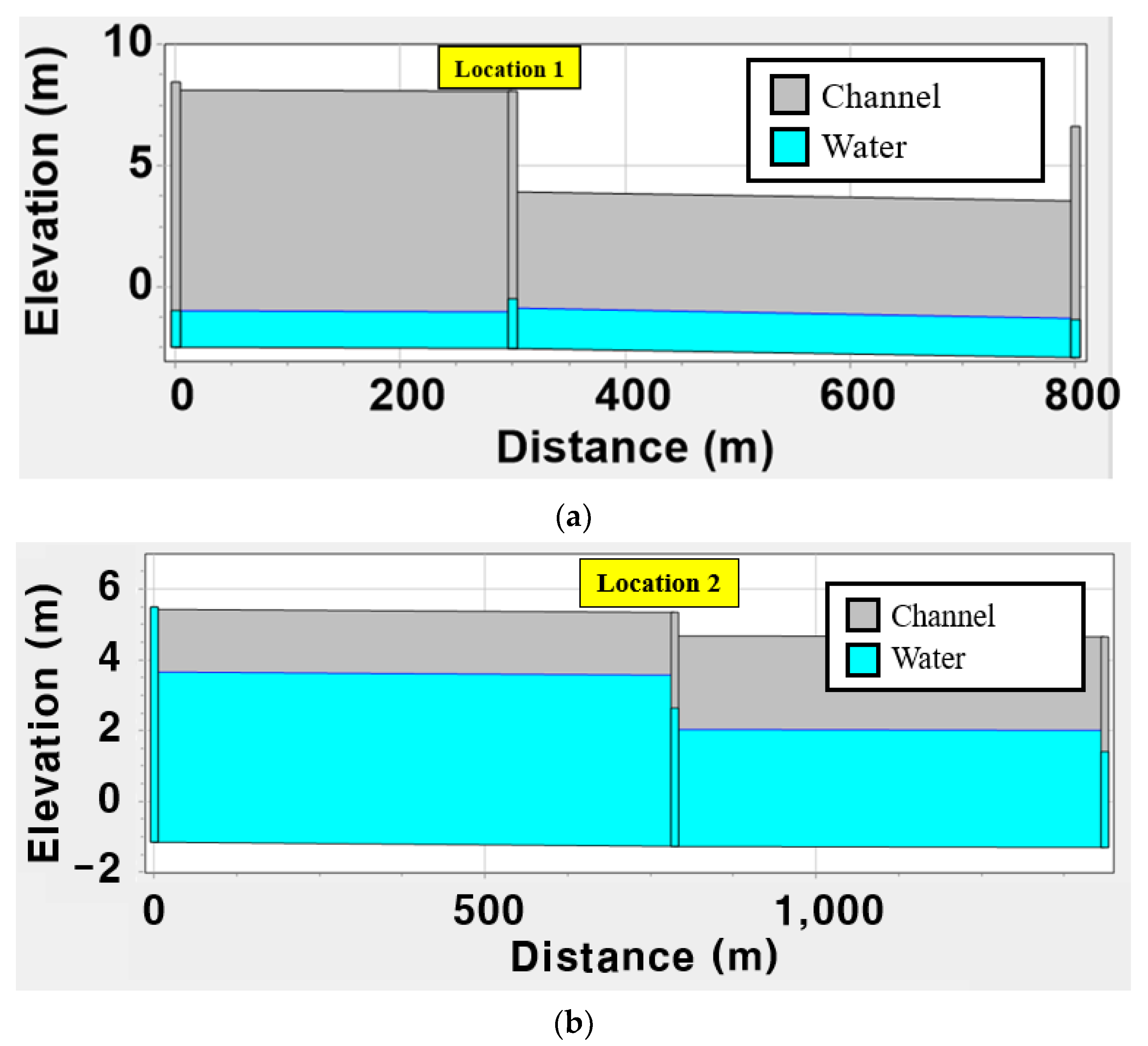
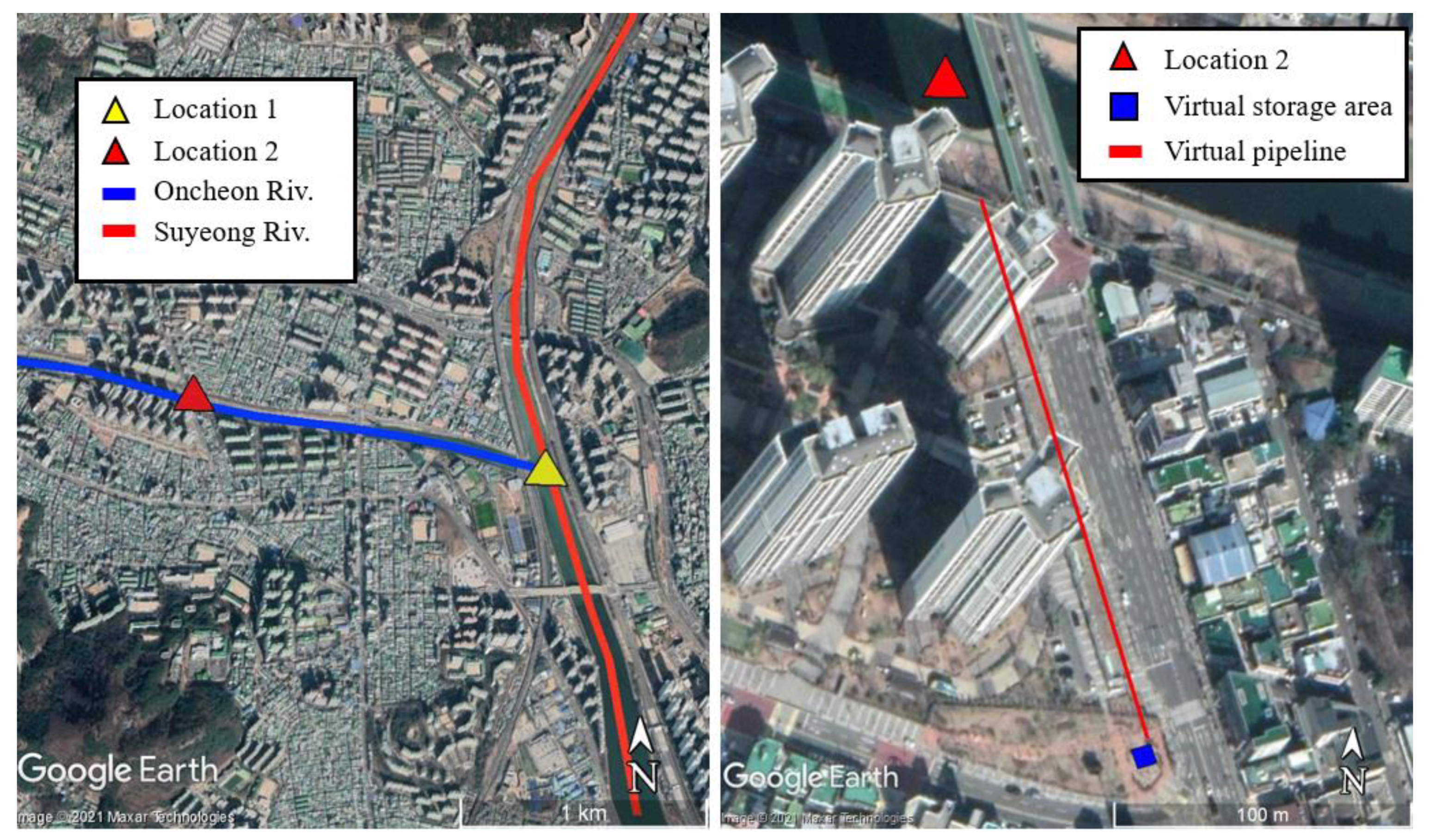
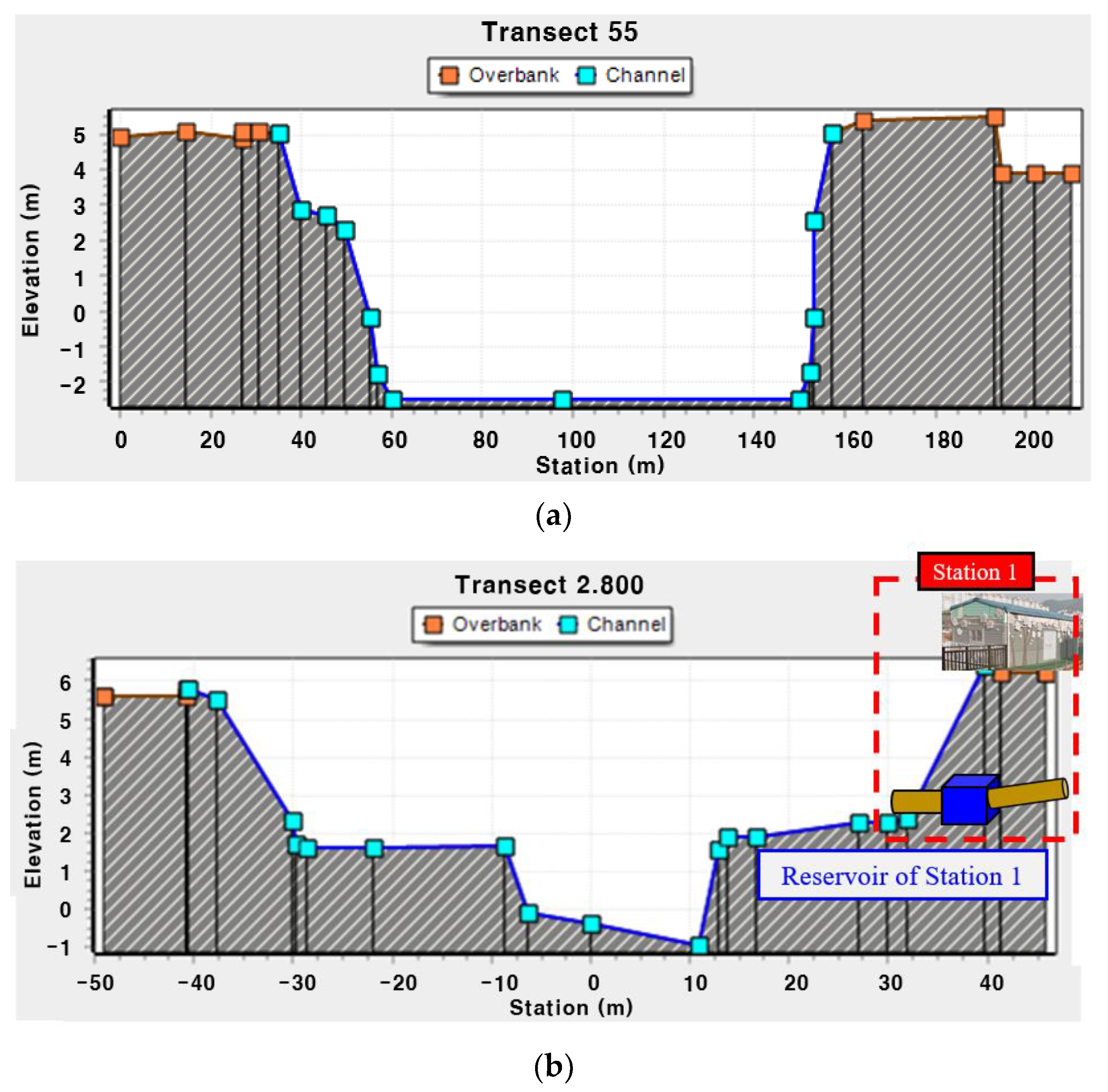
- Morphologically, Location 1 is a trapezoidal form, while Location 2 is a very narrow riverbed. This is a very vulnerable form of Location 2 (Figure 11).
- Location 2 has a low bed slope (Figure 12).
- Because the Oncheon River joins the Suyeong River, the discharge of the Oncheon River is delayed when the water level of the Suyeong River rises.
- The outlet for station 1 is discharged from the walkway located in the middle, not at the top of the channel, as shown in Figure 11b.
- The SWMM provided by the U.S. Environmental Protection Agency is a one-dimensional analysis model.
- The SWMM ‘control’ function does not support complex commands.
3.2. Addressing Structural Problems of Location 2
4. Conclusions
Author Contributions
Funding
Institutional Review Board Statement
Informed Consent Statement
Data Availability Statement
Conflicts of Interest
References
- Mei, X.; Dai, Z.; Darby, S.E.; Gao, S.; Wang, J.; Jiang, W. Modulation of extreme flood levels by impoundment significantly offset by floodplain loss downstream of the Three Gorges Dam. Geophys. Res. Lett. 2018, 45, 3147–3155. [Google Scholar] [CrossRef]
- Leandro, J.; Chen, K.F.; Wood, R.R.; Ludwig, R. A scalable flood-resilience-index for measuring climate change adaptation: Munich city. Water Res. 2020, 173, 115502. [Google Scholar] [CrossRef] [PubMed]
- Tabari, H. Extreme value analysis dilemma for climate change impact assessment on global flood and extreme precipitation. J. Hydrol. 2021, 593, 125932. [Google Scholar] [CrossRef]
- Arnell, N.W.; Gosling, S.N. The impacts of climate change on river flood risk at the global scale. Clim. Chang. 2016, 134, 387–401. [Google Scholar] [CrossRef] [Green Version]
- Lee, M.J.; Kang, J.E.; Jeon, S.W. Application of frequency ratio model and validation for predictive flooded area susceptibility mapping using GIS. In Proceedings of the 2012 IEEE International Geoscience and Remote Sensing Symposium, Munich, Germany, 22–27 July 2012; pp. 895–898. [Google Scholar] [CrossRef]
- Busan Metropolitan City. Report on the Schematic Plan of the Suyeong River; Busan Metropolitan City: Busan, Korea, 2014. [Google Scholar]
- Busan Metropolitan City. Report on the Schematic Plan of the Oncheon River; Busan Metropolitan City: Busan, Korea, 2017. [Google Scholar]
- Winsemius, H.C.; Aerts, J.C.J.H.; van Beek, L.P.H.; Bierkens, M.F.P.; Bouwman, A.; Jongman, B.; Kwadijk, J.C.J.; Ligtvoet, W.; Lucas, P.L.; van Vuuren, D.P.; et al. Global drivers of future river flood risk. Nat. Clim. Chang. 2016, 6, 381–385. [Google Scholar] [CrossRef]
- Kundzewicz, Z.W.; Pińskwar, I.; Brakenridge, G.R. Changes in river flood hazard in Europe: A review. Hydrol. Res. 2018, 49, 294–302. [Google Scholar] [CrossRef]
- Kundzewicz, Z.W.; Buda, S.; Yanjun, W.; Jun, X.; Jinlong, H.; Tong, J. Flood risk and its reduction in China. Adv. Water Resour. 2019, 130, 37–45. [Google Scholar] [CrossRef]
- Duží, B.; Vikhrov, D.; Kelman, I.; Stojanov, R.; Juřička, D. Household measures for river flood risk reduction in the Czech Republic. J. Flood Risk Manag. 2017, 10, 253–266. [Google Scholar] [CrossRef]
- Choo, Y.M.; Jo, D.J.; Yun, G.S.; Lee, E.H. A study on the improvement of flood forecasting techniques in urban areas by considering rainfall intensity and duration. Water 2019, 11, 1883. [Google Scholar] [CrossRef] [Green Version]
- Blazkova, S.; Beven, K. Flood frequency estimation by continuous simulation of subcatchment rainfalls and discharges with the aim of improving dam safety assessment in a large basin in the Czech Republic. J. Hydrol. 2004, 292, 153–172. [Google Scholar] [CrossRef]
- Badenko, V.; Badenko, N.; Nikonorov, A.; Molodtsov, D.; Terleev, V.; Lednova, J.; Maslikov, V. Ecological Aspect of Dam Design for Flood Regulation and Sustainable Urban Development. MATEC Web Conf. 2016, 73. [Google Scholar] [CrossRef] [Green Version]
- Choo, Y.M.; Sim, S.B.; Choe, Y.W. A study on urban inundation using SWMM in Busan, Korea, using existing dams and artificial underground waterways. Water 2021, 13, 1708. [Google Scholar] [CrossRef]
- Harimurti, S.W. Retention Pond and Pump Station as an Alternative to Flood Management in Bengawan Jero Irrigation Area. IOP Conf. Ser. Mater. Sci. Eng. 2020, 858. [Google Scholar] [CrossRef]
- Kim, B.; Sanders, B.F.; Han, K.; Kim, Y.; Famiglietti, J.S. Calibration of stormwater management model using flood extent data. Proc. Inst. Civ. Eng. Water Manag. 2014, 167, 17–29. [Google Scholar] [CrossRef] [Green Version]
- Jafari, F.; Mousavi, S.J.; Yazdi, J.; Kim, J.H. Real-time operation of pumping systems for urban flood mitigation: Single-period vs. multi-period optimization. Water Resour. Manag. 2018, 32, 4643–4660. [Google Scholar] [CrossRef]
- Chen, W.; Wang, W.; Huang, G.; Wang, Z.; Lai, C.; Yang, Z. The capacity of grey infrastructure in urban flood management: A comprehensive analysis of grey infrastructure and the green-grey approach. Int. J. Disaster Risk Reduct. 2021, 54, 102045. [Google Scholar] [CrossRef]
- Busan Metropolitan City. Maintenance Guidelines for Accident Prevention Excellent Reservoir in Seogumsa District; Busan Metropolitan City: Busan, Korea, 2017. [Google Scholar]
- Rossman, L.A. Storm Water Management Model. User’s Manual Version 5.1; National Risk Management Research Laboratory Office of Research and Development U.S. Environmental Protection Agency: Cincinnati, OH, USA, 2015; pp. 220–223. [Google Scholar]
- Korea Meteorological Administration. Available online: https://data.kma.go.kr/data/grnd/selectAwsRltmList.do?pgmNo=56 (accessed on 15 September 2021).
- Information Disclosure Portal. Available online: https://www.open.go.kr/com/main/mainView.do?mainBgGubun=search (accessed on 12 January 2021).
- Public Data Portal. Available online: https://www.data.go.kr/ (accessed on 12 January 2021).
- Fewtrell, T.J.; Neal, J.C.; Bates, P.D.; Harrison, P.J. Geometric and structural river channel complexity and theprediction of urban inundation. Hydrol. Process. 2011, 25, 3173–3186. [Google Scholar] [CrossRef]
- Chen, W.; Huang, G.; Zhang, H. Urban stormwater inundation simulation based on SWMM and diffusive overland-flow model. Water Sci. Technol. 2017, 76, 3392–3403. [Google Scholar] [CrossRef] [PubMed]
- Seenu, P.Z.; Rathnam, V.; Jayakumar, K.V. Visualisation of urban flood inundation using SWMM and 4D GIS. Spat. Inf. Res. 2020, 28, 459–467. [Google Scholar] [CrossRef]
- Ahiablame, L.; Shakya, R. Modeling flood reduction effects of low impact development at awatershed scale. J. Environ. Manag. 2016, 171, 81–91. [Google Scholar] [CrossRef]


| Sortation | Sum | Crop Land | Forest | Urban Areas | Water Area | |
|---|---|---|---|---|---|---|
| Suyeong River | Area (km2) | 200.06 | 41.68 | 88.84 | 45.66 | 23.88 |
| Ratio (%) | 100.00 | 20.83 | 44.41 | 22.82 | 11.94 | |
| Oncheon River | Area (km2) | 56.28 | 10.43 | 7.12 | 27.73 | 11.00 |
| Ratio (%) | 100.00 | 18.53 | 12.65 | 49.27 | 19.55 | |
| Input Parameters | |||
|---|---|---|---|
| Node | ㆍInveer El. ㆍMax. Depth ㆍInitial Depth | ㆍTidal Curve ㆍStorage Curve | |
| Links | ㆍMax. Depth ㆍLength ㆍRoughness | ㆍInlet Offset ㆍOutlet Offset ㆍInitial Flow | ㆍPump Curve |
| Subcatchments | ㆍArea ㆍWidth ㆍSlope (%) | ㆍImpervious Area (%) | |
| Parameter | Station 1 | Station 2 | Station 3 | Station 4 | Station 5 |
|---|---|---|---|---|---|
| Reservoir area (m2) | 10 | 400 | 500 | 38 | 1010 |
| Reservoir capacity (m3) | 61 | 1200 | 1700 | 75 | 8500 |
| Drainage amount (m3/min) | 100 | 784 | 100 | 44 | 1460 |
| Date | Apply New Operation Method Only | New Operation Method after Structural Troubleshooting | |
|---|---|---|---|
| Location 1 | Location 2 | ||
| Flood Reduction (m3) | |||
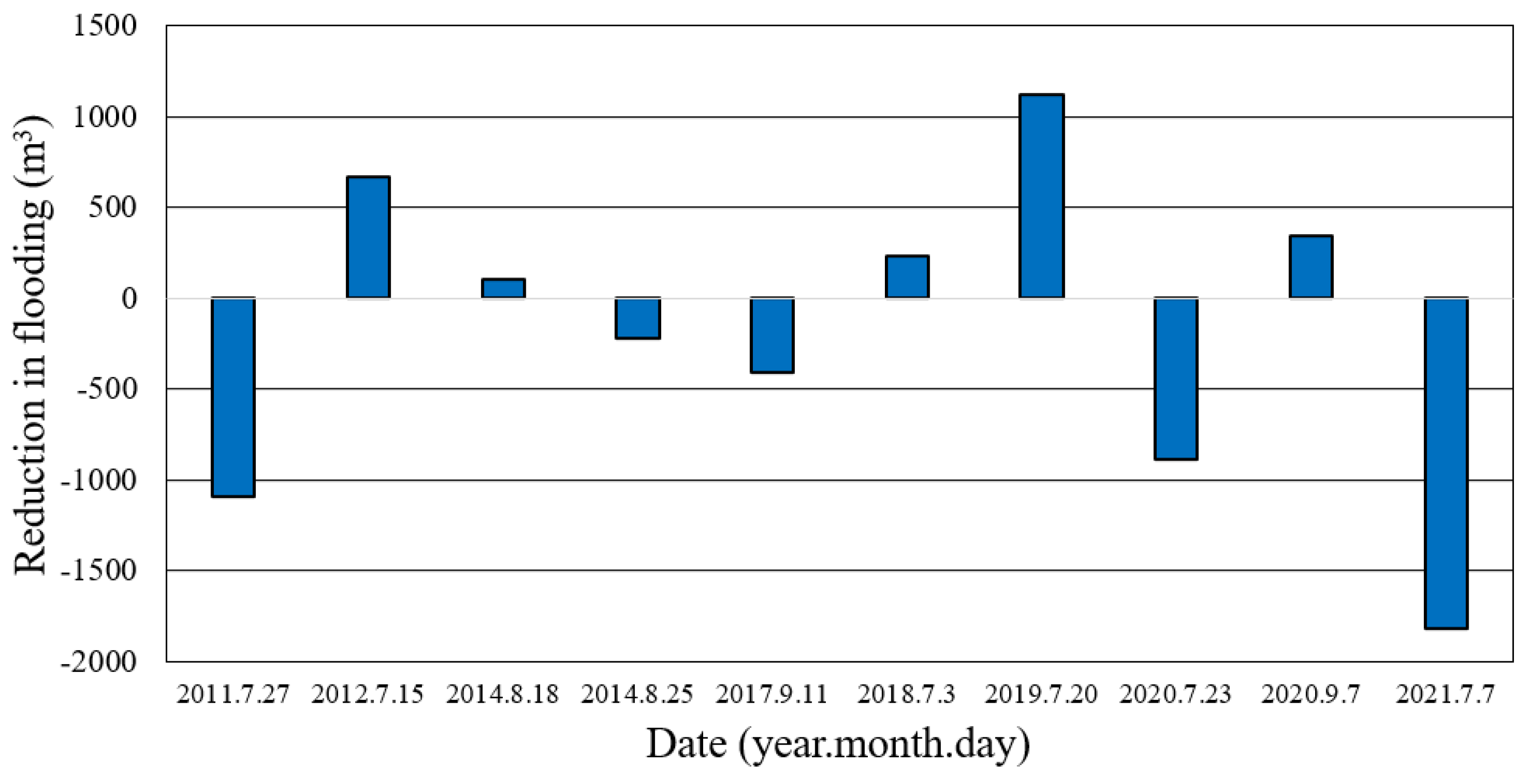
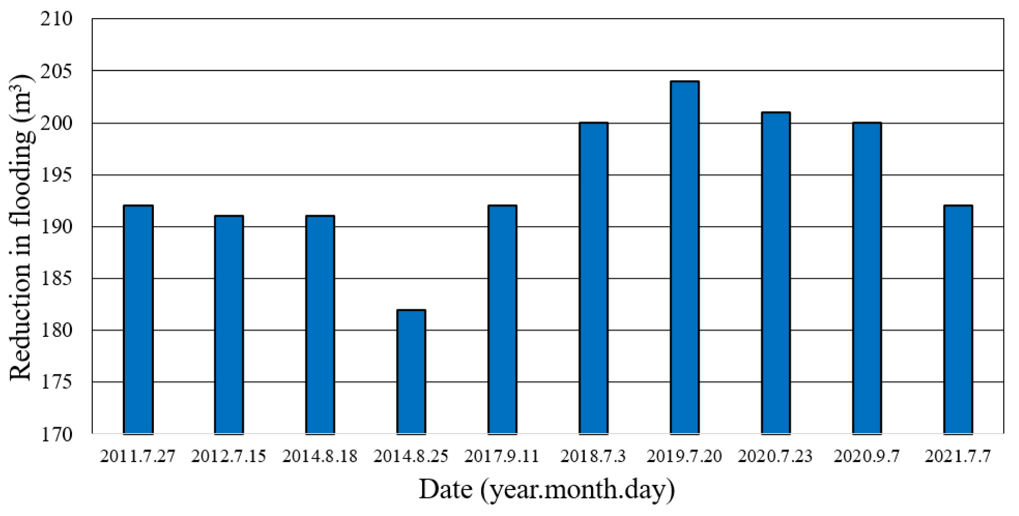
| 2011.07.27 | 3452 | −1093 | 192 |
| 2012.07.15 | 3962 | 668 | 191 |
| 2014.08.18 | 4024 | 107 | 191 |
| 2014.08.25 | 4957 | −217 | 182 |
| 2017.09.11 | 7378 | −412 | 192 |
| 2018.07.03 | none | 232 | 200 |
| 2019.07.20 | none | 1121 | 204 |
| 2020.07.23 | 1222 | −886 | 201 |
| 2020.09.07 | 4750 | 348 | 200 |
| 2021.07.07 | 437 | −1817 | 192 |
Publisher’s Note: MDPI stays neutral with regard to jurisdictional claims in published maps and institutional affiliations. |
© 2021 by the authors. Licensee MDPI, Basel, Switzerland. This article is an open access article distributed under the terms and conditions of the Creative Commons Attribution (CC BY) license (https://creativecommons.org/licenses/by/4.0/).
Share and Cite
Choo, Y.-M.; Kim, J.-G.; Park, S.-H.; Choo, T.-H.; Choe, Y.-W. Method for Operating Drainage Pump Stations Considering Downstream Water Level and Reduction in Urban River Flooding. Water 2021, 13, 2741. https://doi.org/10.3390/w13192741
Choo Y-M, Kim J-G, Park S-H, Choo T-H, Choe Y-W. Method for Operating Drainage Pump Stations Considering Downstream Water Level and Reduction in Urban River Flooding. Water. 2021; 13(19):2741. https://doi.org/10.3390/w13192741
Chicago/Turabian StyleChoo, Yeon-Moon, Jong-Gu Kim, Shang-Ho Park, Tai-Ho Choo, and Yeon-Woong Choe. 2021. "Method for Operating Drainage Pump Stations Considering Downstream Water Level and Reduction in Urban River Flooding" Water 13, no. 19: 2741. https://doi.org/10.3390/w13192741
APA StyleChoo, Y.-M., Kim, J.-G., Park, S.-H., Choo, T.-H., & Choe, Y.-W. (2021). Method for Operating Drainage Pump Stations Considering Downstream Water Level and Reduction in Urban River Flooding. Water, 13(19), 2741. https://doi.org/10.3390/w13192741