Article

The Holocene Evolution of the Volturno Coastal Plain (Northern Campania, Southern Italy): Implications for the Understanding of Subsidence Patterns

1
Department of Engineering, Campania University “Luigi Vanvitelli”, Via Roma 29, 81031 Aversa, Italy
2
NACAV SCARL, Via Giulio Vincenzo Bona, 65, 00156 Roma, Italy
*
Author to whom correspondence should be addressed.
Water 2021, 13(19), 2692; https://doi.org/10.3390/w13192692
Submission received: 10 September 2021 / Revised: 25 September 2021 / Accepted: 26 September 2021 / Published: 28 September 2021

Abstract

:
In the Mediterranean area, several alluvial coastal plains, developed after the Holocene transgression, are affected by subsidence. The Volturno alluvial-coastal plain, along the eastern Tyrrhenian Sea (southern Italy) is characterized by subsidence rates determined through InSAR data analysis and ranging between 0 and <−20 mm/year in an area of about 750 kmq across the Volturno River. Inside this area, the pattern of subsidence shows sites with apparently anomalous localized subsidence. To understand the driving mechanisms of this process, a lithostratigraphic reconstruction was provided focusing on the spatial distribution of the horizons considered weak by a geotechnical point of view; then, the subsidence map was overlain spatially with geological data in a Geographic Information System (GIS) environment. The spatial analysis highlighted the major ground deformation occurring within the outer boundary of the incised paleo-valley, corresponding to the Holocene alluvial/transitional filling that overlies a compaction-free Pleistocene basement. Inside this general trend, differential compaction was detected corresponding to the thick occurrence of clay and peat deposits, suggesting that the subsidence rate registered in the plain are due in part to the consolidation of primary settlements of soft and compressible soils that characterize the subsoil of these areas, and in large part to the secondary consolidation settlements.

1. Introduction

Global mean absolute sea-level rise is estimated at around 3 mm/year and projection until 2100 is in a range of 3–10 mm/year [1,2,3,4] (among others). In recent years, most of the world’s major river deltas and related alluvial coastal plains are sinking due to both accelerations in global sea-level rise and subsidence of human and natural origin. In coastal and delta cities around the world, the latter phenomenon is a major threat to infrastructures. The main effects of subsidence also include aquifer salinization, inundation of low lands and coastal erosion, increased vulnerability to flooding and storm surges, among others (for a review see Higgins [5]). The annual estimated damage associated with subsidence worldwide is billions of dollars. Natural and anthropogenic-driven subsidence rates can be 1–2 orders of magnitude greater than the rate of sea-level rise predicted for 2100 [5]. Subsidence in deltas has been investigated long-term; however, only in the 21st century has subsidence “came to be seen as a widespread phenomenon characteristic of deltas” and related coastal plains [4]. The space-based techniques allowed us to quantify the global delta subsidence.
Studies have been carried out to figure out the potential drivers of subsidence. Tectonics, reduced aggradation, volcanism, and fluid extraction are the most investigated causes [6,7,8,9]. Among these, the over-exploitation of groundwater resources is considered a major cause of this phenomenon [3,5].
In spite of this, in coastal and delta areas subsidence can also have natural causes related to the natural compaction of alluvial/coastal plain deposits, mostly consisting of alternating layers of sand, clay, and peat, still compacting under their own weight. In fact, it is necessary to take into account that modern river deltas began to form about 6500 years BP, following the Last Glacial Maximum (LGM), the sea level drop (20 ky), and the subsequent Holocene aggradation and progradation. During the LGM lowstand, rivers started to downcut the coastal lowlands forming incised valleys [10,11,12,13,14]
Fluvial deposits represent the lowstand and transgressive valley fill and are overlain by transgressive and highstand marine/transitional deposits [15], characterized by sands, silts, clays, and peats. Recent studies have demonstrated that natural compaction can drive subsidence of several millimeters for years, especially in coastal organic-rich deposits [7,16,17,18,19,20,21]. Peat, in particular, is the most compressible soil type and may be considered the main one responsible for the local subsidence at many coastal sites. For instance, Bloom [22] estimated that peat in the subsoil of Connecticut’s coastal marshes had lost from 13 to 44% of original thickness since its deposition (7000 years).
The peat compaction is due not only to the lithostatic weight but also to biological and chemical processes within the peat itself [19,23,24,25]. It is clear that as coastal delta plains are complex environments from a geomorphological and stratigraphic point of view, the natural compaction rates can vary by several orders of magnitude laterally at a sub-km scale. The space-based techniques are unable to identify which subsurface layer causes the vertical land movement. In this view, a deep knowledge of the subsurface stratigraphy could allow a better understanding of the phenomenon.
Nevertheless, most investigations have measured compaction rates in the shallow subsurface whereas few data exist that quantify compaction rates over the entire Holocene succession overlying the Pleistocene substrate (i.e., the incised valley filling) (cf. [16,19,26]). Although an engineering approach is of paramount importance to address these issues, a careful geological-stratigraphic characterization would greatly support the understanding of the phenomenon and the engineering projects.
In the Mediterranean area, several alluvial coastal plains, developed after the Holocene transgression, are affected by subsidence [27]. The aim of the present study is to decipher the contribution of the recent sedimentary evolution to the ground deformation trends assessed for almost two decades (years 1992–2010), which characterize the alluvial coastal plain of the Volturno River, located in the northern Campania coastal area (Southern Italy), along the eastern Tyrrhenian Sea. The Holocene stratigraphic architecture of this coastal and deltaic plain has peculiar characteristics that may influence land subsidence, as documented in similar geological settings worldwide. To verify the possible correlation between stratigraphic characteristics and subsidence, an extensive and detailed reconstruction of the stratal architecture was carried out, placing emphasis on the lithological characteristics of the sediments and highlighting those lithologies that are more subject to compaction. The assessment of the subsidence trends was previously based on a temporal analysis and mapping of Persistent Scatterers (PS) data, obtained from interferometric processing of radar satellite ERS-1/2 and RADARSAT scenes of the study area [28]. In the present study, the distribution of ground deformations was compared with the lithostratigraphic architecture reconstructed for the whole Volturno river lower alluvial plain. Geological, stratigraphic, and SAR data have been managed and analyzed in a GIS environment to figure out significant relationships between subsidence patterns and underlying stratigraphic settings.

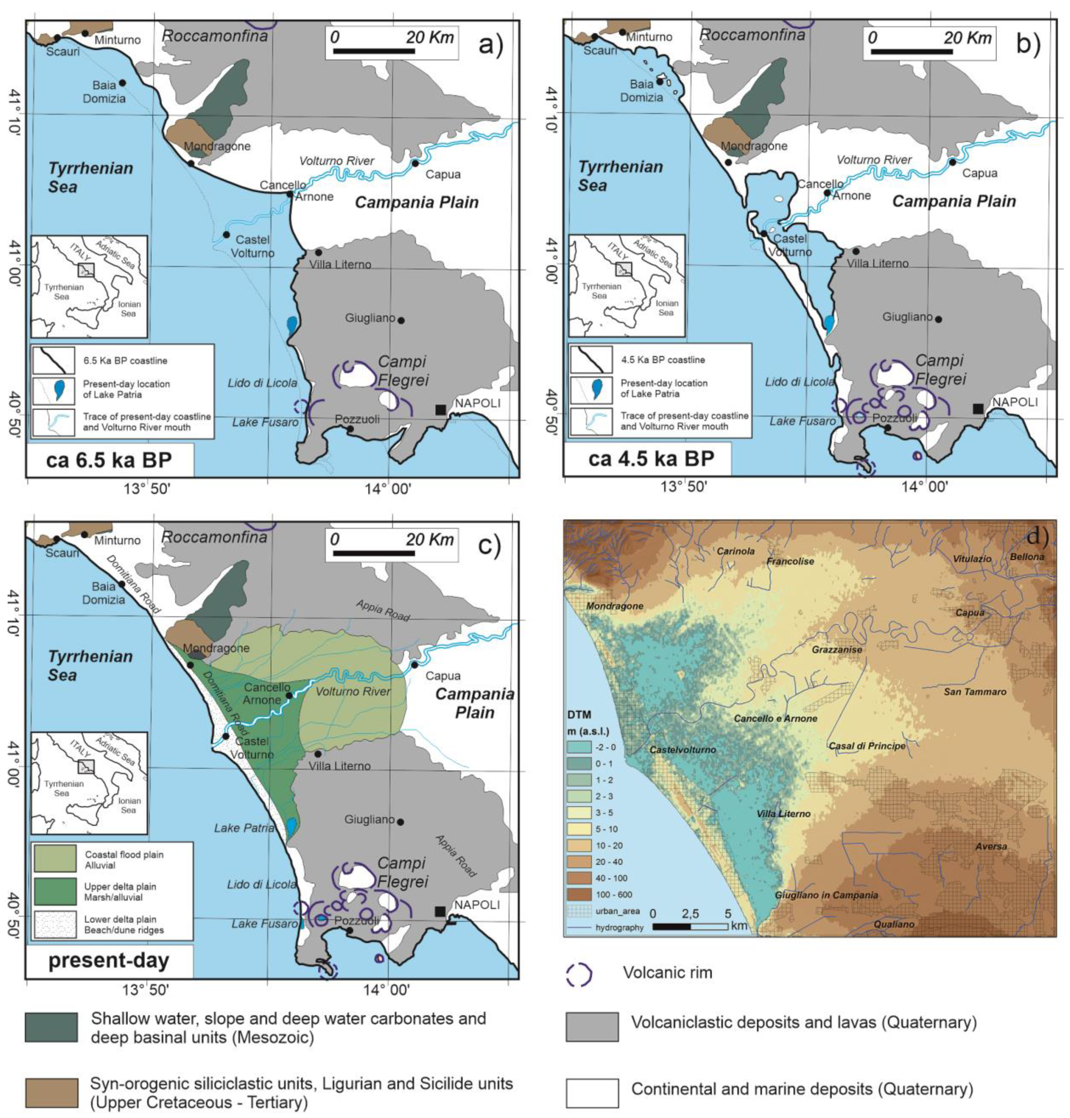
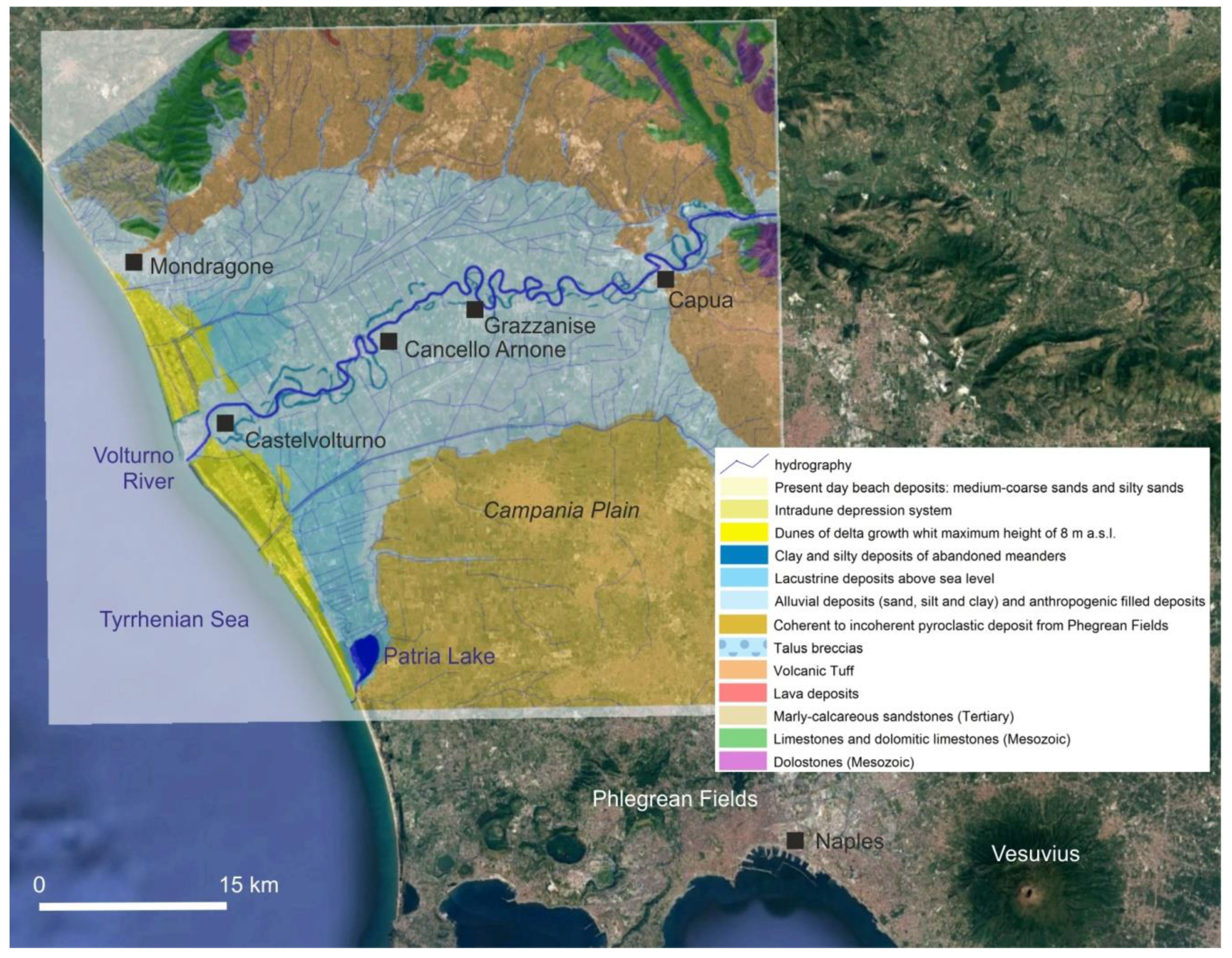
2. Geological Setting

During the Late Pleistocene, the continental margin of the Campania region was affected by significative volcanic activity that produced volcaniclastic aggradation and was largely concomitant with an overall lowering of tectonic subsidence rates and the eustatic regression associated with the last glacioeustatic cycle between 125 ky and 18 ky [29,30]. In particular, Campania Grey Tuff (CGT) deposition, originated by the Campi Flegrei caldera 39 ka eruption, sealed the marine-transitional environments that characterized the Campania plain at that time, and since 39 ky B.P. most of the coastal plain became emersed [31].
A seaward shift of the shoreline was induced by the above glacioeustatic cycle, resulting in a forced regression of paralic-shallow marine depositional systems, while the whole plain emerged and the paleo-Volturno River started fluvial downcutting forming a major incised valley about 15–20 km wide and up to 30 m deep in the depocentre [29,30,32].
The Campania Grey Tuff (CGT) forms the first substrate for the Holocene and recent sedimentation. Similarly, to other Italian alluvial coastal plains, 6.5 ky cal BP a coastal progradational phase allowed the formation of a wave-dominated delta system characterized by lagoonal-marshy areas partially enclosed by well-developed beach-dune ridges originated along the flanking strand plains. Beach and lagoonal environments still persisted along the present coastal zone up to the Roman age (Figure 1a–c). The shape of the palaeo-gulf and the beach-dune system is nowadays printed in the topographic setting (Figure 1d).
The stratigraphic study carried out by the above authors on the whole plain has permitted a preliminary reconstruction of the upper surface of the GCT in the whole Plain and the recognition of the paleo-valley morphology [28,31].

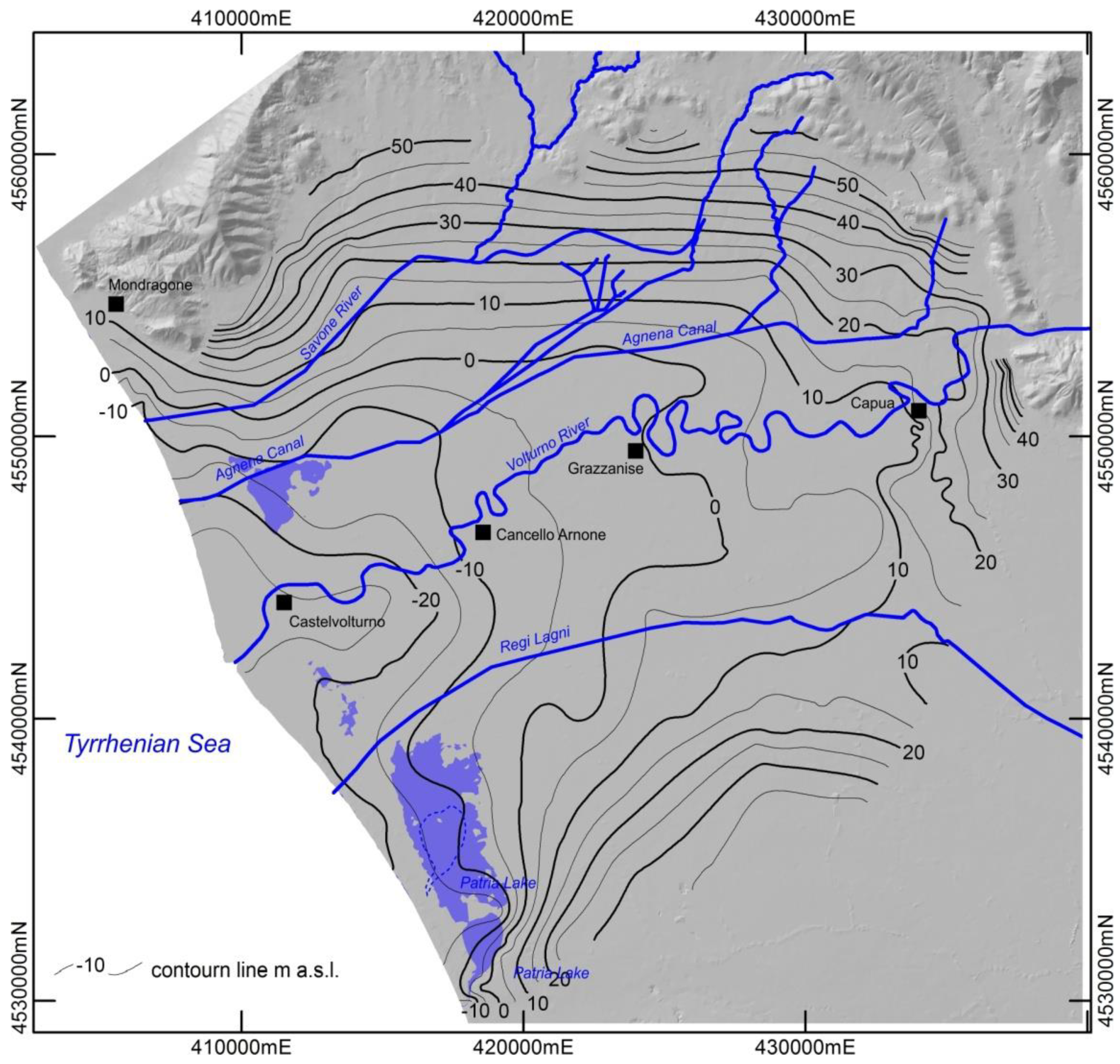
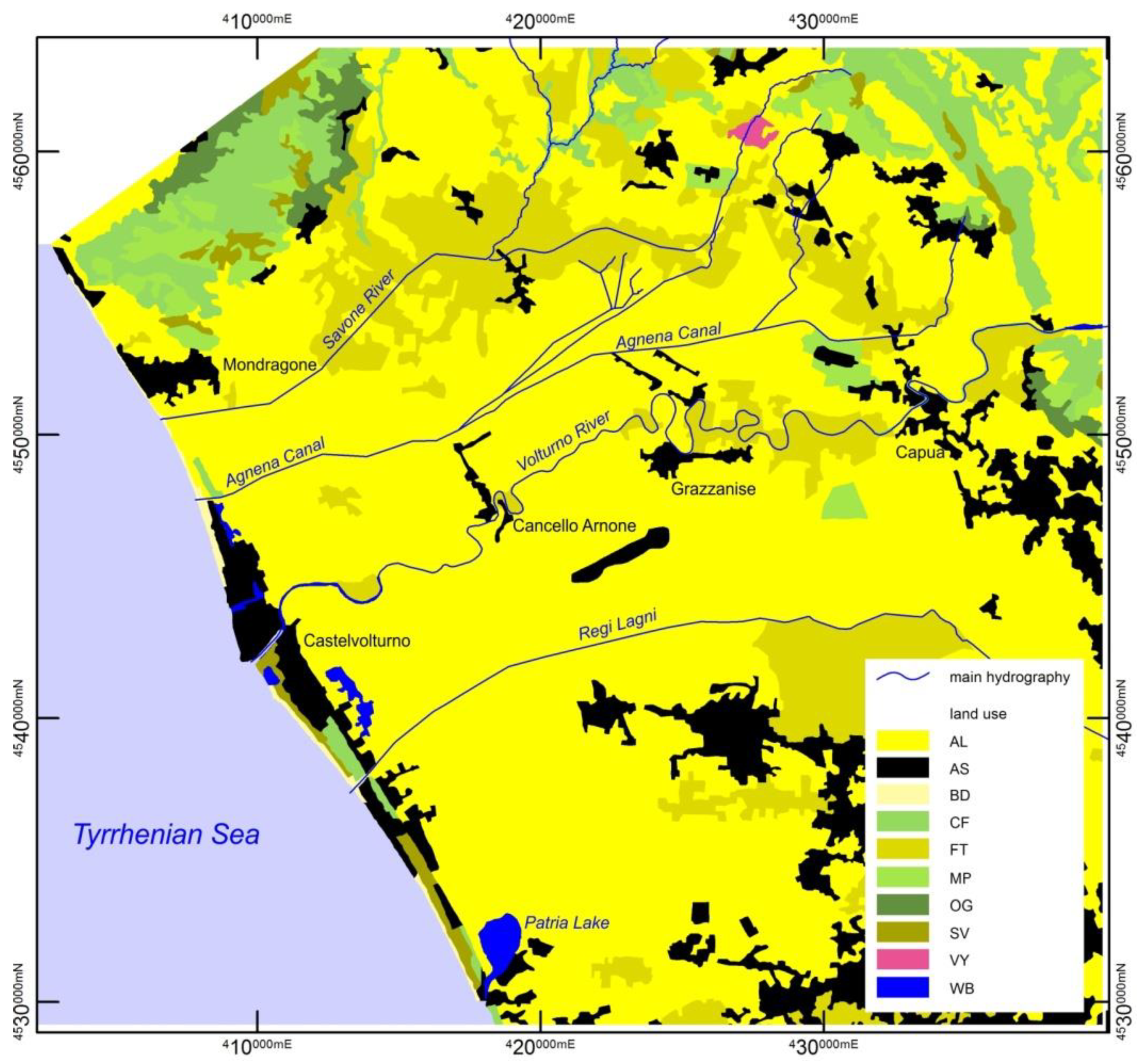
Geomorphology of the Plain and Land Use

The delta/coastal area lies at an elevation between 0 and −2 m bsl. This area represents the remnant of the larger wetland that formed during the last thousand years, nowadays partly preserved in several swamps and a small lagoon (Lake Patria; Figure 2).
Significant landscape changes occurred in the northern Campania plain over the last 100 years following the land reclamation. The rapid economic development and the growth of the urban settlements resulted in the loss of coastal wetland, severe coastal erosion, the degradation of the marine ecosystem, and ultimately seawater intrusion. The impact of changes in the Volturno catchment characteristics over the last two centuries may be considered as the main trigger for the fluvial sediment deficit that dramatically affected the delta and the adjacent coast [33,34,35,36].
The agricultural land use map shows intensive agricultural activity in Volturno’s valley (Figure 3). The lands are almost all farmed both in summer and in the winter season. These activities cover over 85% of the whole area. The urbanized environment takes a fair percentage of the area (7.5%), and it extends mainly along the coast. Grain cereals and grasslands are widespread as they are related to numerous zootechnical activities of the area, mainly represented by buffalo farming.

3. Materials and Methods

The stratigraphic reconstruction relies on more than 1500 shallow borehole stratigraphies (mostly up to 20–30 m in depth) located along the lower Volturno plain. Sedimentological analyses were performed on boreholes drilled on the delta plain and compared with radiocarbon dating previously performed [29,30,37].
Quaternary stratigraphic succession was reconstructed based on boreholes data analysis and field surveys that have also led to the draft of the geological map. The first substrate for the Holocene and recent sedimentation is the Campania Grey Tuff (CGT). Therefore, Stratigraphic data were interpreted and grouped into three main units:
1. Pre-CGT—comprises all the lithofacies deposited before the Phlegrean 39 ky volcanic eruption and settled below the tuff unit;
2. CGT—consists of the Campania Grey Tuff volcanic deposits;
3. Post-CGT—comprises all the sediments deposited after the CGT eruption and that likely constitute the Holocene sedimentation.
The top and bottom depth of each unit surface was recorded in a relational database; the geological data processing was performed in a GIS environment to develop: (i) a 3D geological model of the upper CGT surface; (ii) a thickness map of the post-CGT deposits.
Reference stratigraphic sections were realized for different sectors of the study area to compare thicknesses and lithology of the Post-CGT deposits. In order to understand if and how these different lithologies are related to the distribution of subsidence rates, post-CGT deposits were further classified and gathered on the basis of the main lithological facies such as sands, clays, and peat (Table 1).
A “Lithological Ratio” (LR) was established to define a relationship between the thicknesses of the most compressible deposits (peat and clay) and the total thicknesses of the Post-CGT deposits.
LR =   ( Thickness   Peat + Thickness   clay ) Thickness   POST . CGT
The resulting values were ranked in six classes, “Rates of Lithological Ratio”, in order to evaluate the potential of compressibility (Table 2).
Furthermore, the total thickness of the whole Post-CGT was ranked into thickness range (Thickness Classes—TC; Table 3).
Finally, the LR was correlated with the TC to show the relationships that exist between those two, while the spatial distributions were also compared with subsidence rates.

4. Results

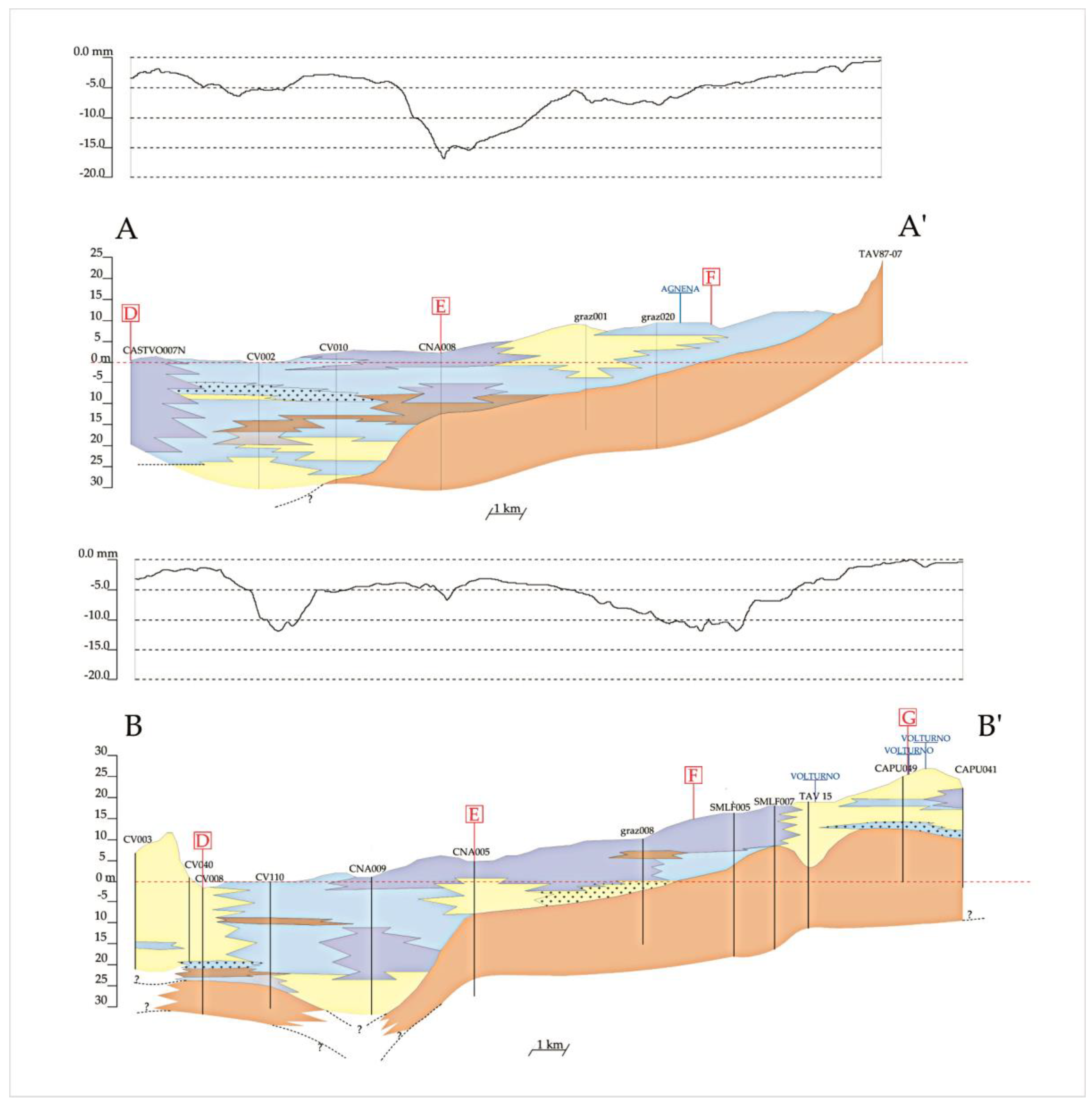
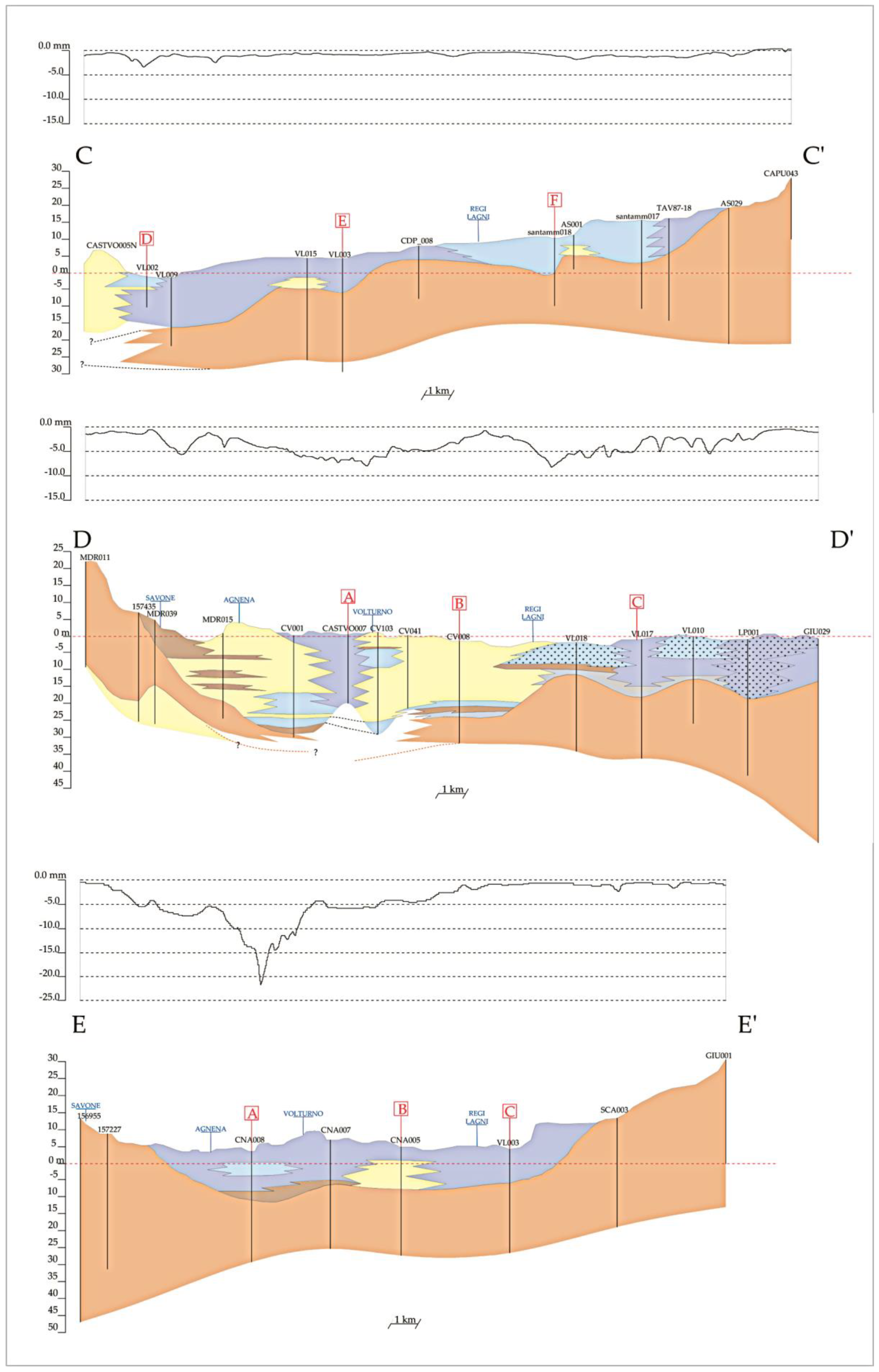
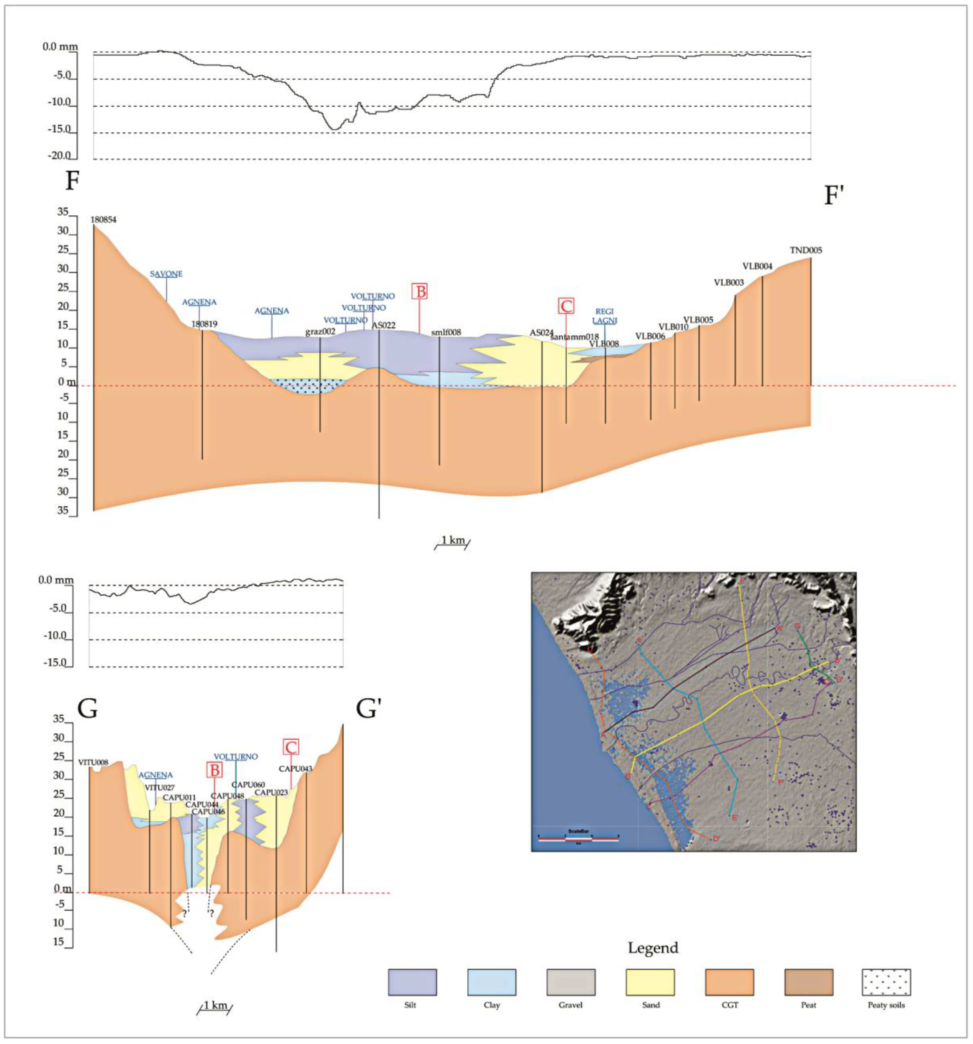
4.1. Subsoil Architecture

An in-depth analysis of borehole data, coupled with a review of previous studies, allowed us to better define the Late Quaternary stratigraphic evolution of the plain. The reconstruction of the upper surface of the GCT in the whole Plain allowed us to recognize a deep downcutting in correspondence of the modern Volturno River course. The top of the above unit deepens moving away from the northern and southern outcrops and towards the axis of the modern Volturno River and the coast. The processing of the stratigraphic data by using the software Surfer highlighted a valley morphology entirely cut into the ignimbritic unit, about 15–20 km wide and up to 30 m deep(Figure 4). The contour map shows the gradual lowering of the top Ignimbrite from the margins of the plain to the river. The tuff lays a few meters below ground level at the edge of the plain whereas it deepens toward the Volturno River axis and the coastal area.
Fluvial terraces characterize the valley flanks suggesting a complex history of channel entrenchment and aggradation [29,32]. Large remobilization of pyroclastic material took place during the re-establishment of the fluvial system, witnessed by the abundance of reworked pyroclastic ash and clasts recognized in the alluvial deposits of the medium-upper part of the valley fill (see further on). Based on Amorosi et al. [29], radiocarbon dating indicates that the valley started to form at about 37 ky cal. BP. The onset of the LGM renewed fluvial downcutting leaving the previously formed terraces about 10 m above the valley floor.
To better outline the above morphology and with the aim to explore the relationships between lithology and subsidence patterns, strike and deep lithostratigraphic sections were constructed across the alluvial plain (Figure 5). Cumulative subsidence profiles were drawn on each profile.
Close to the present coastline (Section D), the tuff top reaches the depth of more than 20 m b.s.l. in correspondence of the Volturno delta system and the Patria Lake area, whereas toward north it is less eroded. The same feature is recognizable in the inner transverse profile (Sections E and F) where the asymmetry of the paleovalley is still evident. The valley apex, close to Capua (Section G) displays a deep and narrow downcutting, likely related to a structural control. The valley axis, outlined in profiles A, B, and C, highlights the deepening of the river incision below the present sea level.
The strike D-D’ and E-E’ sections document the occurrence of thick fine-grained deposits, mostly silty and clay with frequent peaty intercalation either as thick layers of peat or as organic content within the clay-to-sand deposits. The peat contribution is recognizable up to the Grazzanise area, whereas in the innermost sector (Sections F-F’, G-G’) it disappears. This is even more evident in the deep sections (A-A’, B-B’, C-C’) where the highest thicknesses of post-CGT deposits are recognizable up to Cancello Arnone from the present coastline.

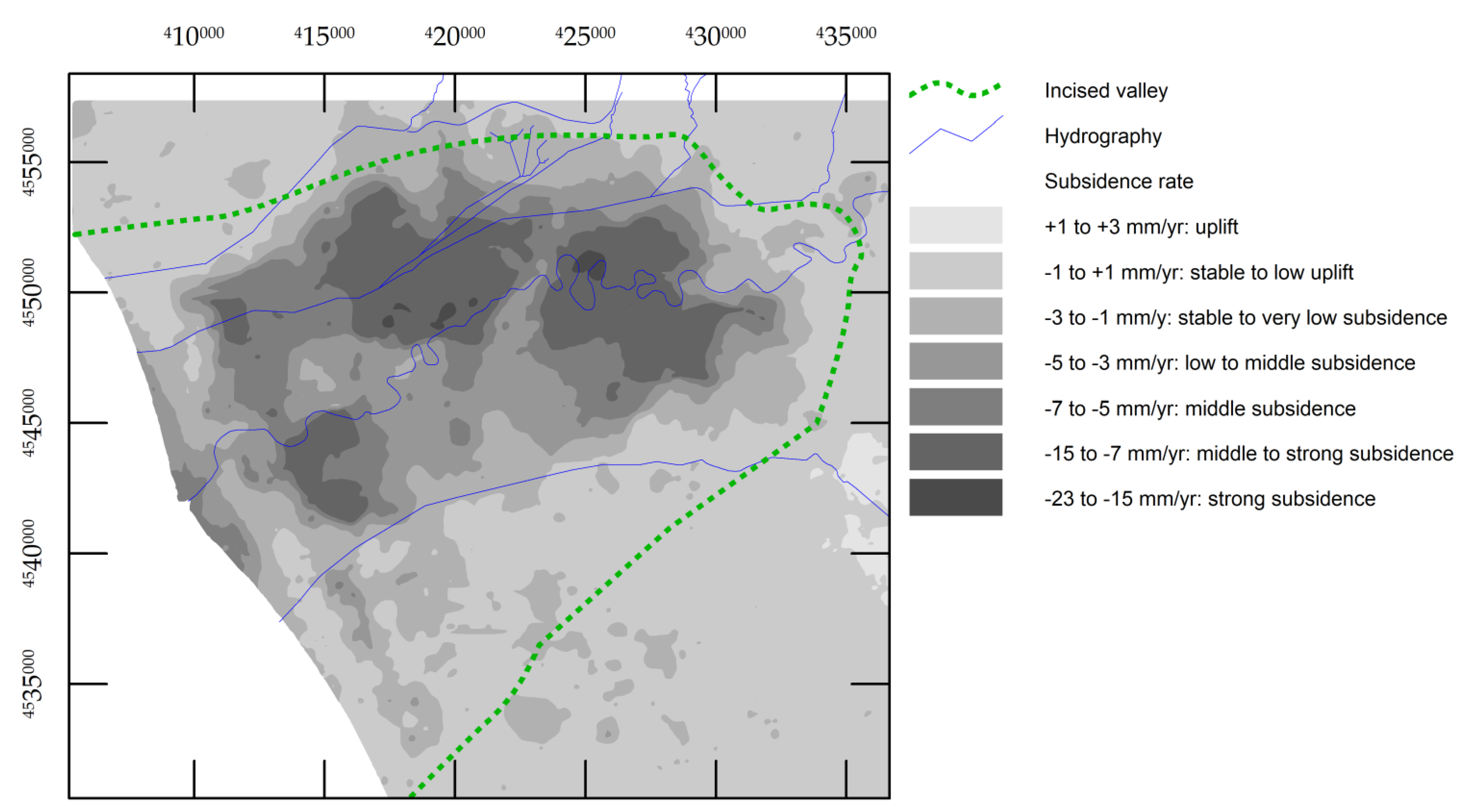
4.2. Vertical Ground Displacement

Matano et al. [28] recorded continuous subsidence in the alluvial plain and the coastal sector in a reference to a period of about twenty years (1992–2010), through the SAR data analysis. Significant increases of ground deformation occur in some places of the plain along the Volturno River course and the coastal plain (Figure 6).
The spatial intersection with the geological data has shown a sharp overlay of the subsiding areas with the paleo-valley perimeter, considering as stable the areas corresponding to subsidence rates comprised between −1 and +1 mm/year. Most of the Volturno River Plain, which covers about 215 km2 of the investigated area, is characterized by significant subsidence, with values ranging from −15 to −23 mm/year. The major peaks are located along the Volturno River and around the city of Grazzanise (−15 mm/year). In the coastal sector, close to the mouth of the river, a moderate subsidence rate is recorded, ranging from −5 to −15 mm/year, while the dune ridge shows only minimal deformations. In the remaining part of the plain, north and south of the river, the vertical displacements due to subsidence are moderate (from −10 to −3 mm/year).
The cumulative subsidence profiles associated with the geological cross-sections provide a picture of the displacement rates across the above sectors. Strike sections display the increased rates of vertical displacement along the Volturno axis, corresponding to the deepest incision in the tuff horizon. The highest values were recognized in the inner profiles E and F where about 15 m thick transitional/alluvial sediments rest above the CGT upper surface. The sea-land trend of the subsidence rates can be better observed in the deep profiles (A, B, C) characterized by a saw-shape curve with the greatest displacement occurring in the area north and south of the Volturno River. These values do not correspond to comparable thicknesses of the Holocene deposits lying on the tuff unit.

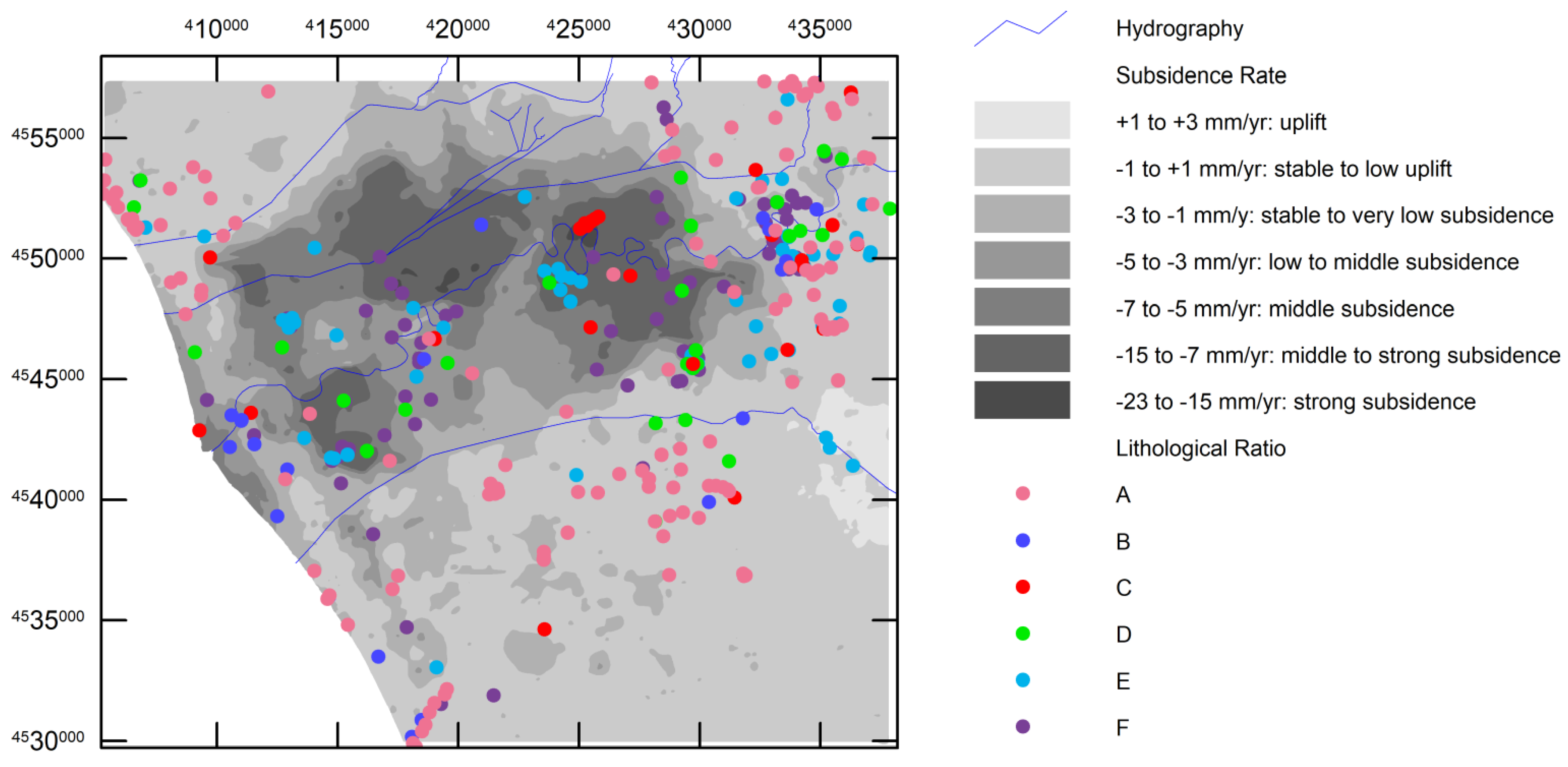
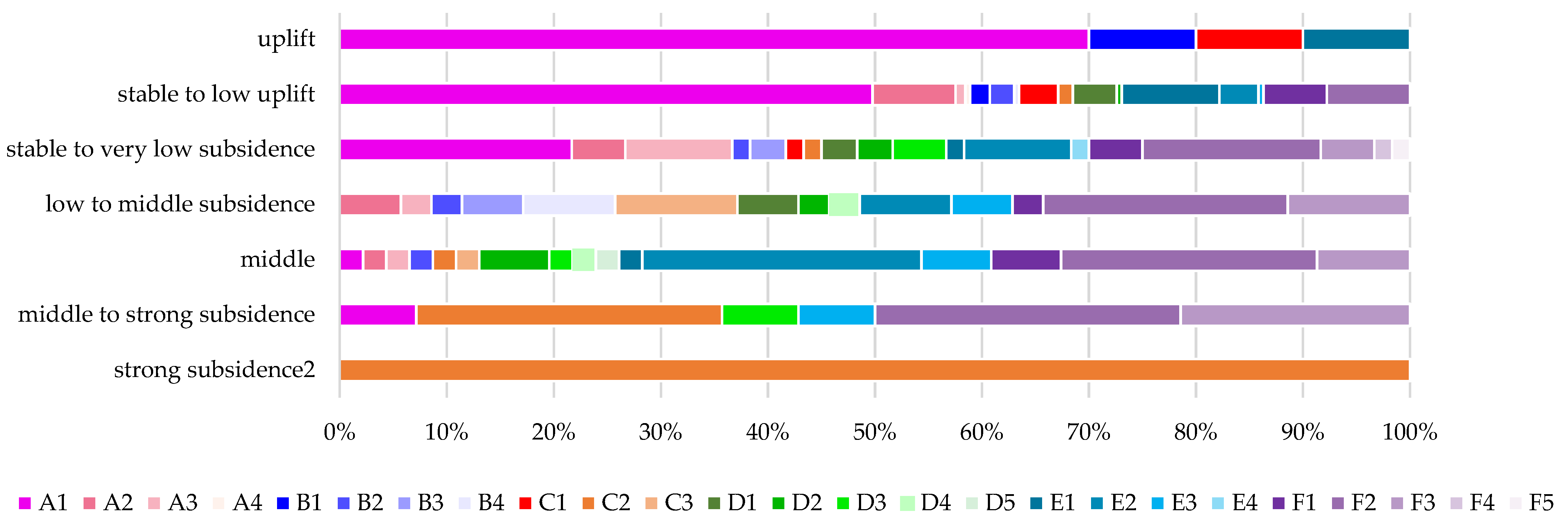
4.3. Subsidence vs. Stratigraphic Structure

In order to better constrain the relationship between lithological data and subsidence patterns, the subsequent step was to identify the thickness of materials highly subject to secondary consolidation compared to the total thickness of post-CGT deposits. The LR were displayed compared to the subsidence values (also hierarchized) (Figure 7).
The first two classes of LR are found in correspondence with the lower annual subsidence rates while ratios greater than 0.50 are present in strongly subsiding areas. However, in the most subsided areas along the Volturno River, close to Grazzanise and Cancello Arnone, the distribution of the lithological data does not seem to have such an immediate relationship with the subsidence. The LR, in fact, does not express the absolute value of the total thickness of the post-CGT cover; similar ratios could correspond to very different total thicknesses and therefore have a different influence on displacement. For this reason, the LR was compared with the TC (Table 4).
It is noteworthy that the highest LR corresponds to low thicknesses. To understand the relationship between these results and the subsidence, the spatial distributions were also compared with subsidence rates (Figure 8; Figure S1 and Table S1).
Borehole data with high LR and high TC are found in the correspondence of the zones with medium-high values (not corresponding to the maximum values) of subsidence, while in the zones where the subsidence rates are the highest the geological data show medium-high LR and low TC; this is particularly evident proceeding from the coastal zone towards the interior and can be easily read in the lithological sections A and B of Figure 6.

5. Discussion

Subsidence rates in the Volturno Plain were determined through InSAR data analysis and range between 0 and <−20 mm/year in an area of about 750 kmq across the Volturno River. Inside this area, the pattern of subsidence shows sites with apparently anomalous localized subsidence. To understand the driving mechanisms of this process, a lithostratigraphic reconstruction was provided focusing on the spatial distribution of those lithologies considered weak by a geotechnical point of view; then, the subsidence map was overlain spatially with geological data in a GIS environment.

5.1. Geological Subsoil Model

The geological data analysis allowed us to single out the Holocene depositional evolution and the timing of the delta formation [29,30]. This reconstruction was greatly facilitated by the widespread occurrence of the CGT unit that represents a major marker for the analysis of the subsurface stratigraphic record.
Although we are aware of the low resolution of the map owing to a dishomogeneous grid of the stratigraphic data, the contour map offers, approximately, a general representation of the Campania Grey Tuff top structure in a basin scale. It shows unequivocally the presence in the plain of a valley structure in which the depocentre approximately corresponds with the modern Volturno River course, interpreted as an incised valley originated as a response to the LGM sea-level drop of ca. 120 m below present sea level. The palaeo-valley shows a more steepened slope on the right side, close to the Capua-Grazzanise transect, where a sharp depth drop is detected (from +30 m a.s.l to −5 m). These results agree with the less detailed models previously proposed by literature [38]. Along the left side, the surface more gently slopes towards the Volturno axis.
The CGT top was thus shaped by the Volturno River and the other secondary streams during the last glacial sea-level drop. The river erosion, in particular, accounts for the channel-like incisions recorded in the coastal setting. There, south of the present Volturno outlet, a smooth incision is recognizable close to the Patria Lake and can be inferred to the ancient course of the Clanio River, flowing in the “Literna Palus” (part of the present day lake). This river was reclaimed during the Spanish vice-kingdom as it was affected by ponding and swamping [33].
To the north, the tuff surface is less eroded. This can be explained considering that the streams flowing north of the Volturno represent artificial canals realized during the reclamation interventions carried out during the twentieth century.
Radiocarbon dating performed by Amorosi et al. [29] outlined the existence of a terraced paleo topography dated 37 cal ky BP by which we can suppose a stepwise erosion during the LGM sea-level lowering, as documented for other coeval drainage systems. The presence of terraced surfaces is also outlined in the area between Grazzanise and Cancello e Arnone, in CC’ profile.
The coming back of more mild climatic conditions and the beginning of transgression phases (early Holocene) resulted in the filling of the former incised valley; during the last ca. 7500 cal year BP, following the peak of the transgression and the deceleration of sea-level rise, the progradation of the coast and the surface aggradation took place with the formation of a wide lagoon basin partially enclosed with beach-dune ridges, afterward covered by fluvio-deltaic units (Figure 1).

5.2. Subsidence vs. Geology

The spatial analysis of the SAR data and stratigraphic architecture has demonstrated that the major ground deformation occurs within the perimeter of the incised paleo-valley, filled with Holocene alluvial/transitional deposits overlying a compaction-free Pleistocene basement. This is consistent with the hypothesis that compaction of deeper Holocene strata is still significant [3,16,23,25,39,40,41,42]. Inside this general trend, differential compaction was detected, corresponding to high LR and low TC, proceeding from the coastal zone towards the interior. The explanation of the apparent anomaly can be found firstly in the geological history of the Plain: after the last deglaciation, the coastline moved inland, reaching first the area of Cancello e Arnone and then the area of Grazzanise. The beach-dune system and related marshy area moved inward in a stepway fashion. The lithostratigraphic sea-land transect BB’ in Figure 5 shows the stratigraphic position of the compressible layers (clays and peat) in relation to the different average subsidence rates that show local anomalous increases. The lithological section shows that with the same LR, in the most interior zone, near Grazzanise, the clay and peat deposits are in a higher stratigraphic position than those recognized in the surveys of the coastal area and that they are located mainly towards the basal portions. The two different stratigraphic conditions are associated with different subsidence values, being higher in the first of the two reference areas.
This can be explained given the more recent age of the sediments in the inner part of the plain, the ones corresponding to the maximum ingression of the sea during the Holocene transgression. This can be confirmed by the consideration that most of the compaction of peat, in fact, occurs during the formation phase, mainly due to microbiological and chemical processes in wet environments. Thus the deepest peat deposits (the oldest ones) have already compacted in the first stage of the Holocene transgression [23].
The clayey-peat deposits that characterize the basal intervals of the Castel Volturno area have ages between 10 ka and 12 ka cal B.P., while those identified in the innermost sections, at Grazzanise, and stratigraphically higher, have an age of about 6 ka cal B.P. This suggests that the viscous component of these materials plays an important role in their behavior: the geologically younger soils are still subject to secondary subsidence while the older ones have already undergone much consolidation also because of the lithostatic load.
From a geotechnical point of view, these soils can be classified as fine-grained soil (mostly clayey) with poor mechanical properties (high compressibility and low strength). Moreover, the inclusion of significant amounts of peat and organic matter clearly reflects high values for the coefficient of secondary compression.
As is well known, for problems like that under discussion, clayey soils experience deformations due to: (a) a primary consolidation process that derives from the change of effective stresses as for instance those resulting from loads (livestock, warehouse, buildings) and/or changes of pore water pressures under constant total stresses; (b) a secondary consolidation (or creep) process, that is the continuous soil deformations under constant effective stresses.
From one side, due to the agricultural use of a significant portion of the plain area, a certain amount of water is continuously extracted from the aquifer, thus resulting in a change of boundary conditions (reduction of pore water pressures) inducing downward water flow movement. Being constant the total stresses, based on Terzaghi’s principle, an increase of effective vertical stresses occurs and, consequently, of vertical soil deformation. The latter, integrated over the affected soil volume, will result in a vertical movement at the ground surface. From the other side, even if a primary consolidation process is concluded (that means, pore water pressures are in equilibrium with the hydraulic boundary conditions), creep still induces soil deformations. Once again, these deformations, integrated over the affected soil volume, will result in an additional vertical movement at the ground surface [43].
Previous studies [44] have proved that agricultural and zootechnical activities do not exert significative impact on subsidence trends [28]. Instead, the overlay of these trends with the geological data suggests that the vertical ground deformation is partly controlled by the lithology and stratigraphic architecture of geological units forming the subsurface of the alluvial plain [45].
Subsidence rates due to compaction of Holocene sediments, characterized by a substantial amount of compressible sediments such as peat and organic-rich clay, were documented in several alluvial and deltaic coastal plains worldwide [16,19,21,39,40,41,46,47,48,49,50,51]. Peat compaction was regarded as a key control of coastal evolution in many delta systems [7,19,43], leading to coastal erosion and destruction of coastal wetlands, among others. On the delta of the Po River, peat-based correlations were used to assess deformation of the Holocene strata [25,42], although the patchy distribution of these compressible soils in the estuarine and deltaic subsoil makes the overall assessment difficult. The biggest limitation in many of the coastal and deltaic sequences is that not always a significantly more consolidated Pleistocene substrate occurs to be used as a reference for compaction estimation, which is instead made possible in the Volturno alluvial and coastal plain due to the widespread occurrence of the ignimbrite unit that acts as a marker boundary for the post-LGM evolution.
An attempt to correlate the thickness of the peat layers in the Holocene sequence to the subsidence rates was provided by van Asselen [21] for the Rhine-Meuse delta, where the greatest subsidence was measured in the thickest layers of the central delta. It is clear that compaction will not occur simultaneously for each layer, depending on the stratigraphic position (i.e., age and depth) and spatial distribution. In this regard, to characterize the geomechanical behavior of each horizon, it appears of paramount importance a detailed reconstruction of the vertical stacking of the sedimentary units and their variation over short distances, as demonstrated by Sarti et al. [51].
In this research, we have demonstrated that reconstructed lithological variability in the Volturno plain accounts for the major subsidence rate variations observed. However, unlike the assumptions of van Asselen, the analysis showed that the major settlements are not related to the massive thicknesses of the Holocene sequence but that instead the stratigraphic position of the compressible layers, and therefore age, seems to have a fundamental role, especially since secondary consolidation is time-dependent. Alongside these considerations, it should be taken into account that soil properties such as compressibility, permeability, and coefficients of primary and secondary consolidation, can greatly help in understanding the deformation process under observation and in quantifying the contribution to the overall rate of settlement of primary consolidation and creep. In this view, further studies are needed to provide the distribution of geotechnical parameters for the deposits responsible for the ground settlement in the study area in order to manage potential risks for building damages. For the reasons above expressed, the Volturno coastal and delta plain represents a valid and almost unique laboratory to assess the main variables influencing subsidence and landscape evolution and transformation through time.

6. Conclusions

Over the last two decades, land subsidence in coastal settings has become the most studied phenomenon and its quantification benefited from advanced SAR-based interferometry methods. In coastal areas around the world, this phenomenon is particularly important as it enhances coastal erosion and the loss of coastal wetlands, increasing flood vulnerability, and hence contributes to major economic damages. In recent times, with the aim of providing an opportunity to share expertise in land subsidence (basic research, monitoring, modeling, and management), the IGCP 663 project “Impact, Mechanism, Monitoring of Land Subsidence in Coastal Cities” was promoted by the IUGS and Unesco.
This study is intended to provide a small contribution to the international debate on basic research aimed at the understanding of phenomenology in heterogeneous coastal environments. The main results suggest that among the triggers of subsidence, a key role is played by the subsurface stratigraphic architecture, and in particular by the areal distribution and thickness of Holocene deposits, such as clayey silts, clays, and peats, filling the LGM valley cut in the late Pleistocene volcaniclastic deposits. From a geotechnical point of view, these soils have poor characteristics. They are inconsistent cohesive soils, medium-high compressible. The presence of clay, plastic clay, and peat increases the values of the secondary compression coefficient. We can say that the subsidence rates registered in the plain are due in part to the consolidation of primary settlements of soft and compressible soils that characterize the subsoil of these areas, and in large part to the secondary consolidation settlements. The secondary consolidation settlements are due to the viscous strain of the soil skeleton, deformations that take place even at constant effective pressure, and therefore also (but not only) in primary consolidation exhausted. With this respect, our findings have demonstrated that the highest land displacement values are recorded in correspondence with high thicknesses of compressible materials, but not necessarily corresponding to high thicknesses of the whole Holocene deposits. Furthermore, the stratigraphic position of these layers assumes a significant role since the consolidation is time-dependent. With the aim of sharing research results, the future goal could be to export the methodology developed in this study to other coastal contexts in the Mediterranean area.

Supplementary Materials

The following are available online at https://www.mdpi.com/article/10.3390/w13192692/s1, Figure S1: Graphic distribution of (LR vs. TC) on the Cumulative vertical ground displacement chart, obtained with overlay; Figure S2: Graphic representation of (LR vs. TC) vs. subsidence values. Table S1. (LR vs. TC) vs. subsidence values.

Author Contributions

Conceptualization, D.R. and A.M.; methodology, C.B., R.B. and M.V.; software, C.B. and M.V.; formal analysis, D.R., C.B. and M.V.; investigation, D.R., M.V., C.B., R.B.; data curation, M.V., C.B.; writing—original draft preparation, D.R.; writing—review and editing, D.R., A.M., C.B.; supervision, D.R., A.M. All authors have read and agreed to the published version of the manuscript.

Funding

The scholarship and research activities of Carla Buffardi were part of the Environment, Design and Innovation Ph.D. program. This research was also funded by the V:ALERE 2020 Program (VAnviteLli pEr la RicErca) of the University of Campania “Luigi Vanvitelli”.

Institutional Review Board Statement

Not applicable.

Informed Consent Statement

Not applicable.

Acknowledgments

This paper benefited from stimulating discussion with prof. Luciano Picarelli and from helpful comments by two anonymous reviewers.

Conflicts of Interest

The authors declare no conflict of interest. The funders had no role in the design of the study; in the collection, analyses, or interpretation of data; in the writing of the manuscript, or in the decision to publish the results.

References

  1. Warrick, R.A.; Provost, C.L.; Meier, M.F.; Oerlemans, J.; Woodworth, P.L. Changes in sea level. In Houghton; Meira Filho, L.G., Houhton, J.T., Callander, B.A., Harris, N., Klattenberg, A., Maskell, K., Eds.; Cambridge University Press: Cambridge, UK, 1996; pp. 359–405. [Google Scholar]
  2. Lambeck, K.; Antonioli, F.; Anzidei, M.; Ferranti, L.; Leoni, G.; Scicchitano, G.; Silenzi, S. Sea level change along the Italian coast during the Holocene and projections for the future. Quat. Int. 2011, 232, 250–257. [Google Scholar] [CrossRef]
  3. Erkens, G.; Bucx, T.; Dam, R.; De Lange, G.; Lambert, J. Sinking coastal cities. Proc. Int. Assoc. Hydrol. Sci. 2015, 372, 189–198. [Google Scholar] [CrossRef] [Green Version]
  4. Higgins, S.A. Review: Advances in delta-subsidence research using satellite methods. Hydrogeol. J. 2015, 24, 587–600. [Google Scholar] [CrossRef]
  5. Allison, M.; Yuill, B.; Törnqvist, T.; Amelung, F.; Dixon, T.; Erkens, G.; Stuurman, R.; Jones, C.; Milne, G.; Steckler, M.; et al. Global risks and research priorities for coastal subsidence. Eos 2016, 97. [Google Scholar] [CrossRef]
  6. Poland, J.F.; Davis, G.H. Land subsidence due to withdrawal of fluids. In Reviews in Engineering Geology; Varnes, D.J., Kiersch, G., Eds.; Geological Society of America: Boulder, CO, USA, 1969; Volume 2, pp. 187–269. [Google Scholar] [CrossRef]
  7. Long, A.; Waller, M.; Stupples, P. Driving mechanisms of coastal change: Peat compaction and the destruction of late Holocene coastal wetlands. Mar. Geol. 2006, 225, 63–84. [Google Scholar] [CrossRef] [Green Version]
  8. Xie, X.; Heller, P. Plate tectonics and basin subsidence history. GSA Bull. 2006, 19, 55–64. [Google Scholar] [CrossRef]
  9. Galloway, D.L.; Burbey, T.J. Review: Regional land subsidence accompanying groundwater extraction. Hydrogeol. J. 2011, 19, 1459–1486. [Google Scholar] [CrossRef]
  10. Dabrio, C.J.; Zazo, C.; Goy, J.L.; Sierro, F.; Borja, F.; Lario, J.; A González, J.; A Flores, J. Depositional history of estuarine infill during the last postglacial transgression (Gulf of Cadiz, Southern Spain). Mar. Geol. 2000, 162, 381–404. [Google Scholar] [CrossRef] [Green Version]
  11. Wellner, R.W.; Bartek, L.R. The effect of sea level, climate, and shelf physiography on the development of incised-valley complexes: A modern example from the East China sea. J. Sediment. Res. 2003, 73, 926–940. [Google Scholar] [CrossRef]
  12. Hori, K.; Tanabe, S.; Saito, Y.; Haruyama, S.; Nguyen, V.; Kitamura, A. Delta initiation and Holocene sea-level change: Example from the Song Hong (Red River) delta, Vietnam. Sediment. Geol. 2004, 164, 237–249. [Google Scholar] [CrossRef]
  13. Blum, M.D.; Tomkin, J.H.; Purcell, A.; Lancaster, R.R. Ups and downs of the mississippi delta. Geology 2008, 36, 675. [Google Scholar] [CrossRef]
  14. Amorosi, A.; Rossi, V.; Sarti, G.; Mattei, R. Coalescent valley fills from the late quaternary record of tuscany (Italy). Quat. Int. 2013, 288, 129–138. [Google Scholar] [CrossRef]
  15. Dalrymple, R.W.; Zaitlin, B.A.; Boyd, R. Estuarine facies models; conceptual basis and stratigraphic implications. J. Sediment. Res. 1992, 62, 1130–1146. [Google Scholar] [CrossRef]
  16. Meckel, T.A.; Brink, U.S.T.; Williams, S.J. Current subsidence rates due to compaction of Holocene sediments in southern Louisiana. Geophys. Res. Lett. 2006, 33, 11403. [Google Scholar] [CrossRef]
  17. Meckel, T.A.; Brink, U.S.T.; Williams, S.J. Sediment compaction rates and subsidence in deltaic plains: Numerical constraints and stratigraphic influences. Basin Res. 2007, 19, 19–31. [Google Scholar] [CrossRef] [Green Version]
  18. Massey, A.C.; Paul, M.A.; Gehrels, W.R.; Charman, D.J. Autocompaction in Holocene coastal back-barrier sediments from south Devon, southwest England, UK. Mar. Geol. 2006, 226, 225–241. [Google Scholar] [CrossRef]
  19. Törnqvist, T.E.; Wallace, D.J.; Storms, J.E.; Wallinga, J.; van Dam, R.; Blaauw, M.; Derksen, M.S.; Klerks, C.J.W.; Meijneken, C.; Snijders, E.M.A. Mississippi delta subsidence primarily caused by compaction of Holocene strata. Nat. Geosci. 2008, 1, 173–176. [Google Scholar] [CrossRef]
  20. Shi, C.; Zhang, D.; You, L.; Li, B.; Zhang, Z.; Zhang, O. Land subsidence as a result of sediment consolidation in the Yellow River Delta. J. Coast Res. 2007, 23, 173–181. [Google Scholar]
  21. Van Asselen, S. The contribution of peat compaction to total basin subsidence: Implications for the provision of accom-modation space in organic-rich deltas. Basin Res. 2011, 23, 239–255. [Google Scholar] [CrossRef]
  22. Bloom, A.L. Peat Accumulation and Compaction in a Connecticut Coastal Marsh. J. Sediment. Res. 1964, 34, 599–603. [Google Scholar]
  23. Van Asselen, S.; Stouthamer, E.; van Asch, T.W. Effects of peat compaction on delta evolution: A review on processes, responses, measuring and modeling. Earth-Sci. Rev. 2009, 92, 35–51. [Google Scholar] [CrossRef]
  24. Koster, K.; Erkens, G.; Zwanenburg, C. A new soil mechanics approach to quantify and predict land subsidence by peat compression. Geophys. Res. Lett. 2016, 43, 10792–10799. [Google Scholar] [CrossRef] [Green Version]
  25. Bruno, L.; Campo, B.; Di Martino, A.; Hong, W.; Amorosi, A. Peat layer accumulation and post-burial deformation during the mid-late Holocene in the Po coastal plain (Northern Italy). Basin Res. 2019, 31, 621–639. [Google Scholar] [CrossRef]
  26. Meckel, T. An attempt to reconcile subsidence rates determined from various techniques in southern Louisiana. Quat. Sci. Rev. 2008, 27, 1517–1522. [Google Scholar] [CrossRef]
  27. Herrera-García, G.; Ezquerro, P.; Tomás, R.; Béjar-Pizarro, M.; López-Vinielles, J.; Rossi, M.; Mateos, R.M.; Carreón-Freyre, D.; Lambert, J.; Teatini, P.; et al. Mapping the global threat of land subsidence. Science 2021, 371, 34–36. [Google Scholar] [CrossRef]
  28. Matano, F.; Sacchi, M.; Vigliotti, M.; Ruberti, D. Subsidence trends of volturno river coastal plain (Northern Campania, Southern Italy) Inferred by SAR Interferometry Data. Geosci. 2018, 8, 8. [Google Scholar] [CrossRef] [Green Version]
  29. Amorosi, A.; Pacifico, A.; Rossi, V.; Ruberti, D. Late quaternary incision and deposition in an active volcanic setting: The Volturno valley fill, southern Italy. Sediment. Geol. 2012, 282, 307–320. [Google Scholar] [CrossRef]
  30. Sacchi, M.; Molisso, F.; Pacifico, A.; Vigliotti, M.; Sabbarese, C.; Ruberti, D. Late-Holocene to recent evolution of Lake Patria, South Italy: An example of a coastal lagoon within a Mediterranean delta system. Glob. Planet. Chang. 2014, 117, 9–27. [Google Scholar] [CrossRef]
  31. Ruberti, D.; Vigliotti, M.; Rolandi, R.; Di Lascio, M. Effect of paleomorphology on facies distribution of the campania ignimbrite in the northern campania plain, southern Italy. In Vesuvius, Campi Flegrei, and Campanian Volcanism; De Vivo, B., Belkin, H.E., Rolandi, G., Eds.; Elsevier: Amsterdam, The Netherlands, 2020; pp. 207–229. [Google Scholar] [CrossRef]
  32. Ruberti, D.; Sacchi, M.; Pepe, F.; Vigliotti, M. LGM incised valley in a volcanic setting. The northern campania plain (Southern Italy). In Alpine and Mediterranean Quaternary. In Proceedings of the Quaternary: Past, Present, Future—AIQUA Conference, Florence, Italy, 13–14 June 2018; pp. 35–38. [Google Scholar]
  33. Ruberti, D.; Vigliotti, M. Land use and landscape pattern changes driven by land reclamation in a coastal area: The case of Volturno delta plain, Campania Region, southern Italy. Environ. Earth Sci. 2017, 76, 694. [Google Scholar] [CrossRef]
  34. Mastrocicco, M.; Busico, G.; Colombani, N.; Vigliotti, M.; Ruberti, D. Modelling actual and future seawater intrusion in the variconi coastal wetland (Italy) due to climate and landscape changes. Water 2019, 11, 1502. [Google Scholar] [CrossRef] [Green Version]
  35. Donadio, C.; Vigliotti, M.; Valente, R.; Stanislao, C.; Ivaldi, R.; Ruberti, D. Anthropic vs. natural shoreline changes along the northern Campania coast, Italy. J. Coast. Conserv. 2017, 22, 939–955. [Google Scholar] [CrossRef]
  36. Ruberti, D.; Vigliotti, M.; Di Mauro, A.; Chieffi, R.; Di Natale, M. Human influence over 150 years of coastal evolution in the Volturno delta system (southern Italy). J. Coast. Conserv. 2017, 22, 897–917. [Google Scholar] [CrossRef]
  37. Ruberti, D.; Vigliotti, M.; Marzaioli, R.; Pacifico, A.; Ermice, A. Stratigraphic architecture and anthropic impacts on subsoil to assess the intrinsic potential vulnerability of groundwater: The northeastern Campania plain case study, southern Italy. Environ. Earth Sci. 2014, 71, 319–339. [Google Scholar] [CrossRef]
  38. Ortolani, F.; Aprile, F. Principali caratteristiche stratigrafiche e strutturali dei depositi superficiali della Piana Campana. Boll. Soc. Geol. Itl. 1985, 104, 195–206. [Google Scholar]
  39. Higgins, S.A.; Overeem, I.; Steckler, M.S.; Syvitski, J.P.M.; Seeber, L.; Akhter, S.H. InSAR measurements of compaction and subsidence in the Ganges-Brahmaputra Delta, Bangladesh. J. Geophys. Res. Earth Surf. 2014, 119, 1768–1781. [Google Scholar] [CrossRef]
  40. Jones, C.E.; An, K.; Blom, R.G.; Kent, J.D.; Ivins, E.R.; Bekaert, D. Anthropogenic and geologic influences on subsidence in the vicinity of New Orleans, Louisiana. J. Geophys. Res. Solid Earth 2016, 121, 3867–3887. [Google Scholar] [CrossRef]
  41. Bruno, L.; Campo, B.; Costagli, B.; Stouthamer, E.; Teatini, P.; Zoccarato, C.; Amorosi, A. Factors controlling natural subsidence in the Po Plain. Proc. Int. Assoc. Hydrol. Sci. 2020, 382, 285–290. [Google Scholar] [CrossRef]
  42. Yan, X.; Yang, T.; Xu, Y.; Tosi, L.; Stouthamer, E.; Andreas, H.; Minderhoud, P.; Ladawadee, A.; Hanssen, R.; Erkens, G.; et al. Advances and Practices on the Research, Prevention and Control of Land Subsidence in Coastal Cities. Acta Geol. Sin. 2020, 94, 162–175. [Google Scholar] [CrossRef]
  43. Mandolini, A.; Picarelli, L.; Viggiani, C. Un rilevato sperimentale su terreni limo-argillosi organici di origine palustre. Riv. Geoteeniea Ital. 1989, 3, 101–115. [Google Scholar]
  44. Riccio, T. Analysis of Subsidence in Campania Plain. Ph.D. Thesis, University of Campania “Luigi Vanvitelli”, Aversa, Italy, 2016. [Google Scholar]
  45. Ruberti, D.; Mandolini, A.; Matano, F.; Picarelli, L.; Sacchi, M.; Vigliotti, M. Holocene stratigraphic architecture and current land subsidence of the Volturno coastal plain (northern Campania, southern Italy). J. Mediterr. Earth Sci. 2017, 9, 193–196. [Google Scholar]
  46. Phien-Wej, N.; Giao, P.H.; Nutalaya, P. Land subsidence in Bangkok, Thailand. Eng. Geol. 2006, 82, 187–201. [Google Scholar] [CrossRef]
  47. Campolunghi, M.P.; Capelli, G.; Funiciello, R.; Lanzini, M. Geotechnical studies for foundation settlement in Holocenic alluvialdeposits in the city of Rome (Italy). Eng. Geol. 2007, 89, 9–35. [Google Scholar] [CrossRef]
  48. Teatini, P.; Tosi, L.; Strozzi, T. Quantitative evidence that compaction of Holocene sediments drives the present land sub-sidence of the Po Delta, Italy. J. Geophys. Res. 2011, 116. [Google Scholar] [CrossRef]
  49. Teatini, P.; Tosi, L.; Strozzi, T.; Carbognin, L.; Cecconi, G.; Rosselli, R.; Libardo, S. Resolving land subsidence within the Venice Lagoon by persistent scatterer SAR interferometry. Phys. Chem. Earth 2012, 40, 72–79. [Google Scholar] [CrossRef]
  50. Sarti, G.; Rossi, V.; Amorosi, A. Influence of Holocene stratigraphic architecture on ground surface settlements: A case study from the City of Pisa (Tuscany, Italy). Sediment. Geol. 2012, 281, 75–87. [Google Scholar] [CrossRef]
  51. Koster, K.; Stafleu, J.; Cohen, K.; Stouthamer, E.; Busschers, F.; Middelkoop, H. Three-dimensional distribution of organic matter in coastal-deltaic peat: Implications for subsidence and carbon dioxide emissions by human-induced peat oxidation. Anthropocene 2018, 22, 1–9. [Google Scholar] [CrossRef]
Figure 1. Sketch-map of the inferred evolution of the Volturno delta plain from the Late Holocene to present. (based on [30,31]): (a) reconstruction of the approximate location of coastline around the maximum marine ingression (ca. 6.5 ka BP; (b) coastline at ca. 4.5 ka BP, showing the onset of back-barrier lagoonal environments at the mouth of the Volturno River; (c) present day setting of the Volturno delta plain; (d) Digital Terrain Model with 70 m cell size.
Water 13 02692 g001
Figure 2. Schematic geologic map of the study area.
Water 13 02692 g002
Figure 3. Land use map. Key: AL Arable Land; AS Artificial Surfaces; BD Beaches, Dunes; CF Coniferous Forest; FT Fruit Trees; MP Meadow and Pasture; OG Olive Grove; SV Sclerophyllous Vegetation; VY Vineyards; WB Water Bodies.
Water 13 02692 g003
Figure 4. Contour map of the upper surface of the CGT. A valley morphology is evident along the present Volturno River course and the Regi Lagni canal (previously Clanio River).
Water 13 02692 g004
Figure 5. Deep (A-A’, B-B’, C-C’) and strike (D-D’, E-E’, F-F’, G-G’) geological cross-sections with subsidence profile during 1992–2010 time span (in mm). Red labels refer to the intersection of the geological profiles; in blue the hydrography.
Water 13 02692 g005aWater 13 02692 g005bWater 13 02692 g005c
Figure 6. Cumulative vertical ground displacement estimated during 1992–2010 (based on Matano et al., 2018).
Water 13 02692 g006
Figure 7. LR vs. subsidence values.
Water 13 02692 g007
Figure 8. (LR vs. TC) vs. subsidence values. Labels correspond to the matrix (LR vs. TC). Input data and output graphic detail in Figure S1 and Table S1. Note that medium values of subsidence correspond to high LR and high TC (mostly E and F), whereas the highest vertical displacements correspond to high LR and low TC.
Water 13 02692 g008
Table 1. Example of the lithological database of the stratigraphic columns.
IDEastingNorthingTotal ThicknessTuff ThicknessPOST-CGTPeat ThicknessClay ThicknessClay and Peat Thickness
MDR0392,429,487.284,550,926.8119.0012.007.004.200.004.20
CV1062,435,452.904,542,001.0331.001.5029.500.0018.0018.00
CV0102,434,970.054,546,819.0328.700.0028.700.2017.5017.70
Table 2. Ranking of the Lithological Ratios derived by Equation (1).
LRThickness (m)
A0.00
B0.00–0.20
C0.20–0.40
D0.40–0.60
E0.60–0.85
F0.85–1.00
Table 3. Ranking of the Thickness Classes of the Post-CGT.
TCThickness Range (m)
P10–10
P210–20
P320–30
P430–50
P550–80
Table 4. Matrix of the relationship between the LR and TC.
12345Tot.
A14826151 190
B5864 23
C13125 30
D15752130
E292971 66
F2055151192
Tot2301375392431
Publisher’s Note: MDPI stays neutral with regard to jurisdictional claims in published maps and institutional affiliations.

