
Mapping Risk to Land Subsidence: Developing a Two-Level Modeling Strategy by Combining Multi-Criteria Decision-Making and Artificial Intelligence Techniques


Abstract
:1. Introduction
2. Methodology
2.1. Basic ALPRIF Framework
Transforming Vulnerability to Risk
2.2. InSAR Processing
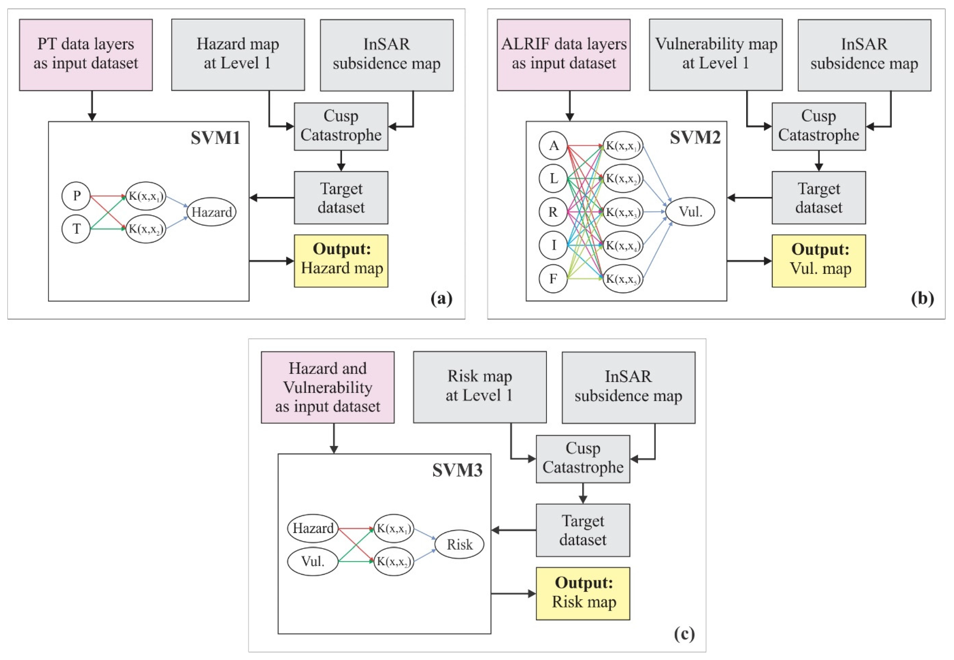
2.3. Modeling Strategy at Level 1 by Fuzzy Catastrophe Scheme
2.4. Modeling Strategy at Level 2 by SVM
2.5. Performance Metrics
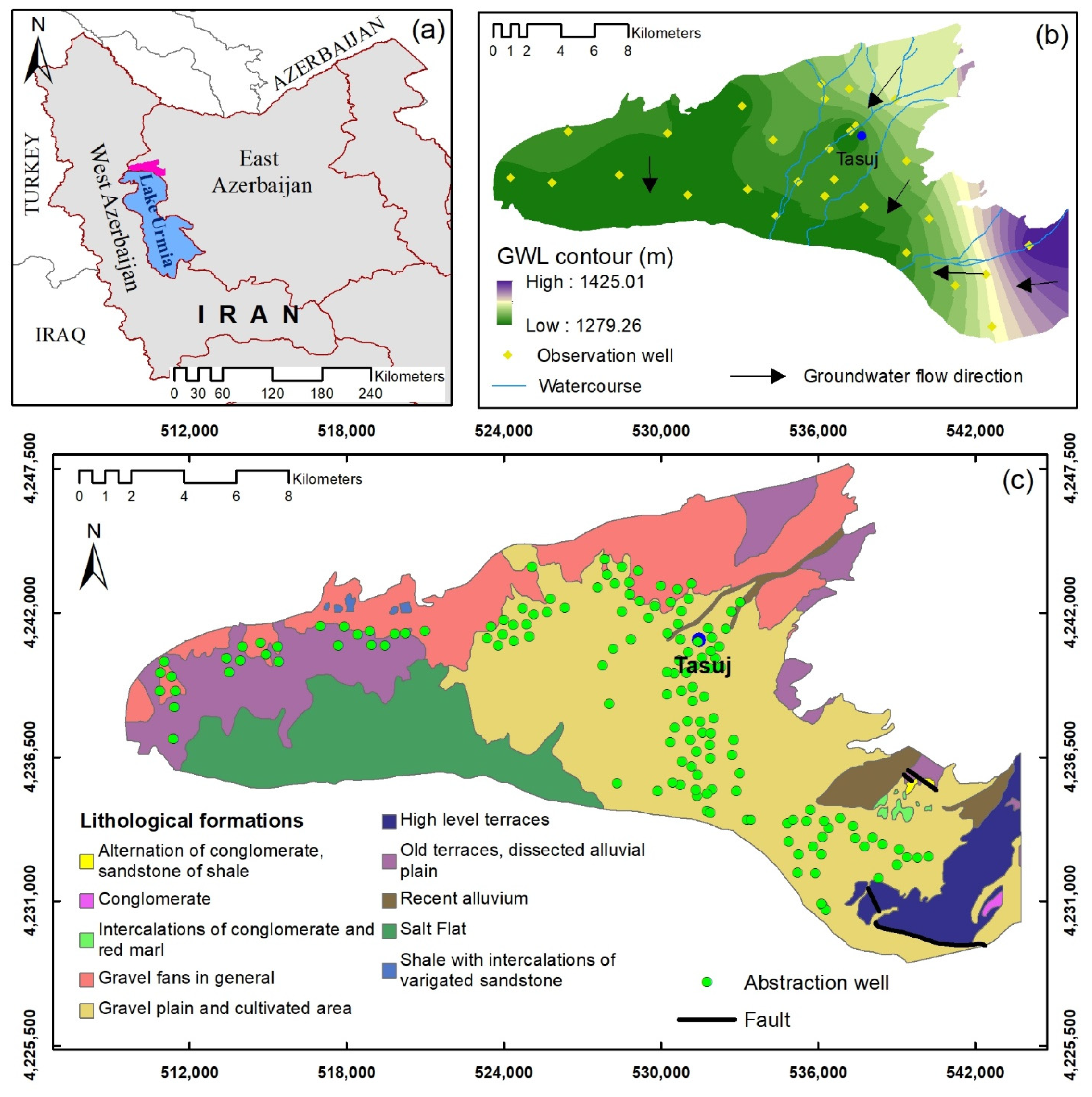
3. Study Area
4. Result
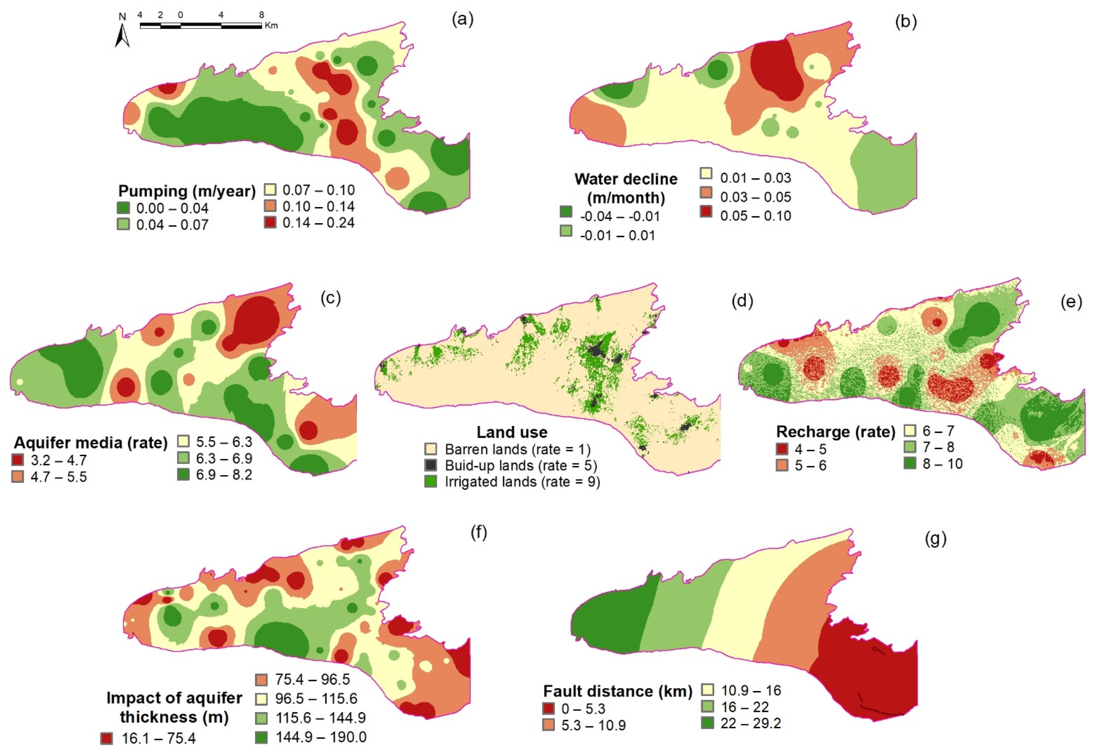
4.1. Preparation of ALPRIFT Data Layer
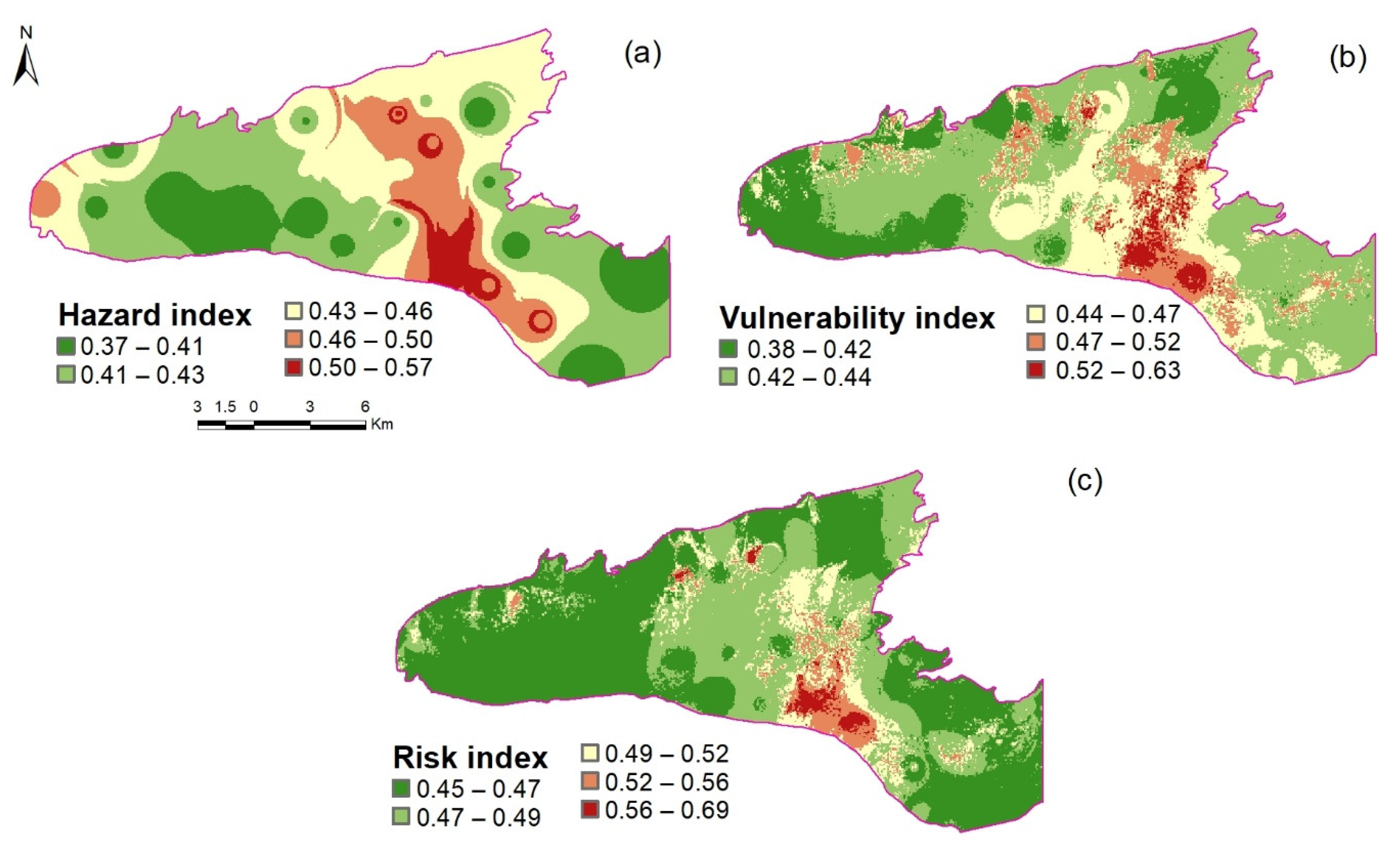
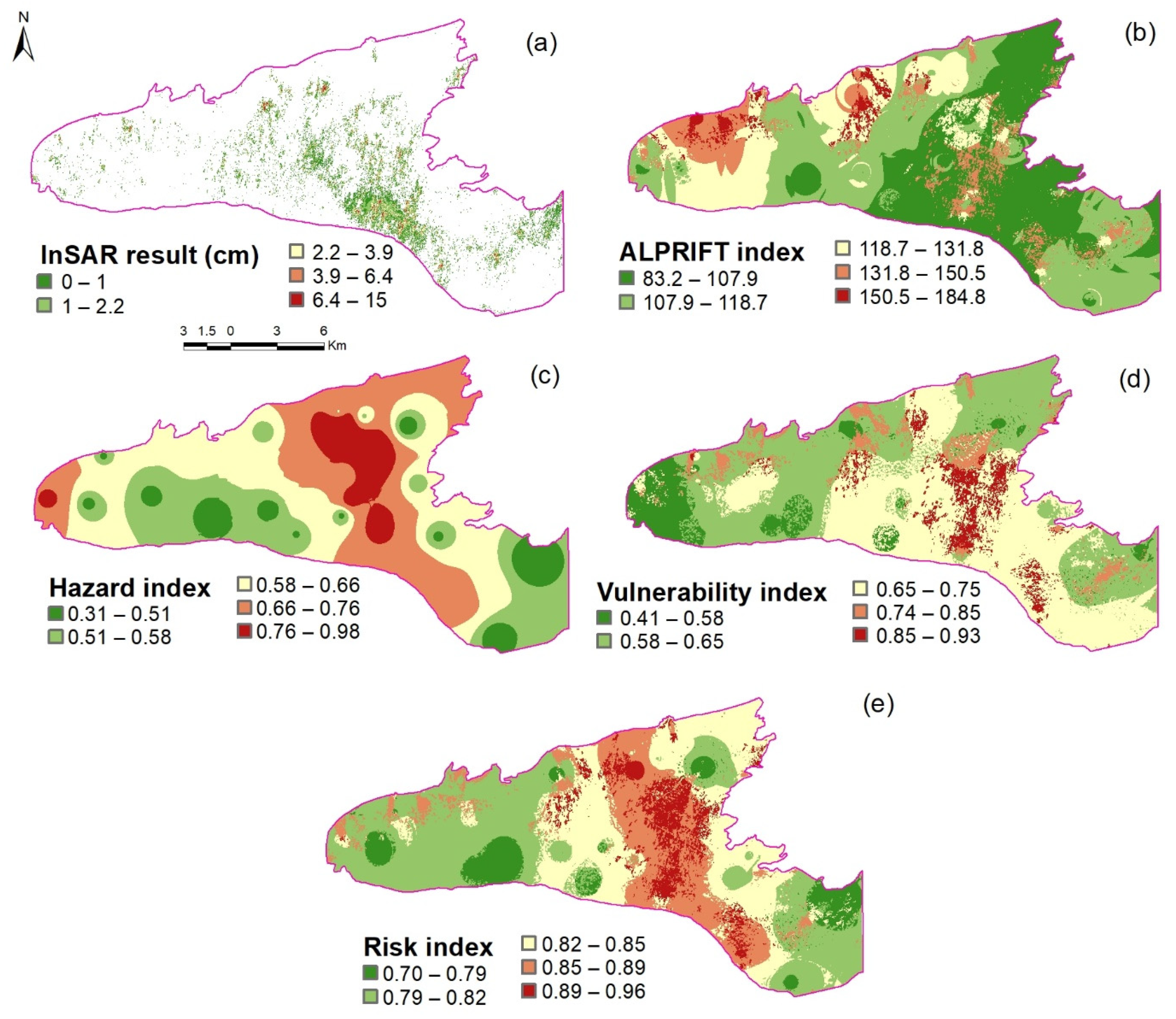
4.2. Results of InSARProcessing, Hazard, Vulnerability and Risk Indices at Level 1
4.3. Hazard, Vulnerability, and Risk Indices at Level 2
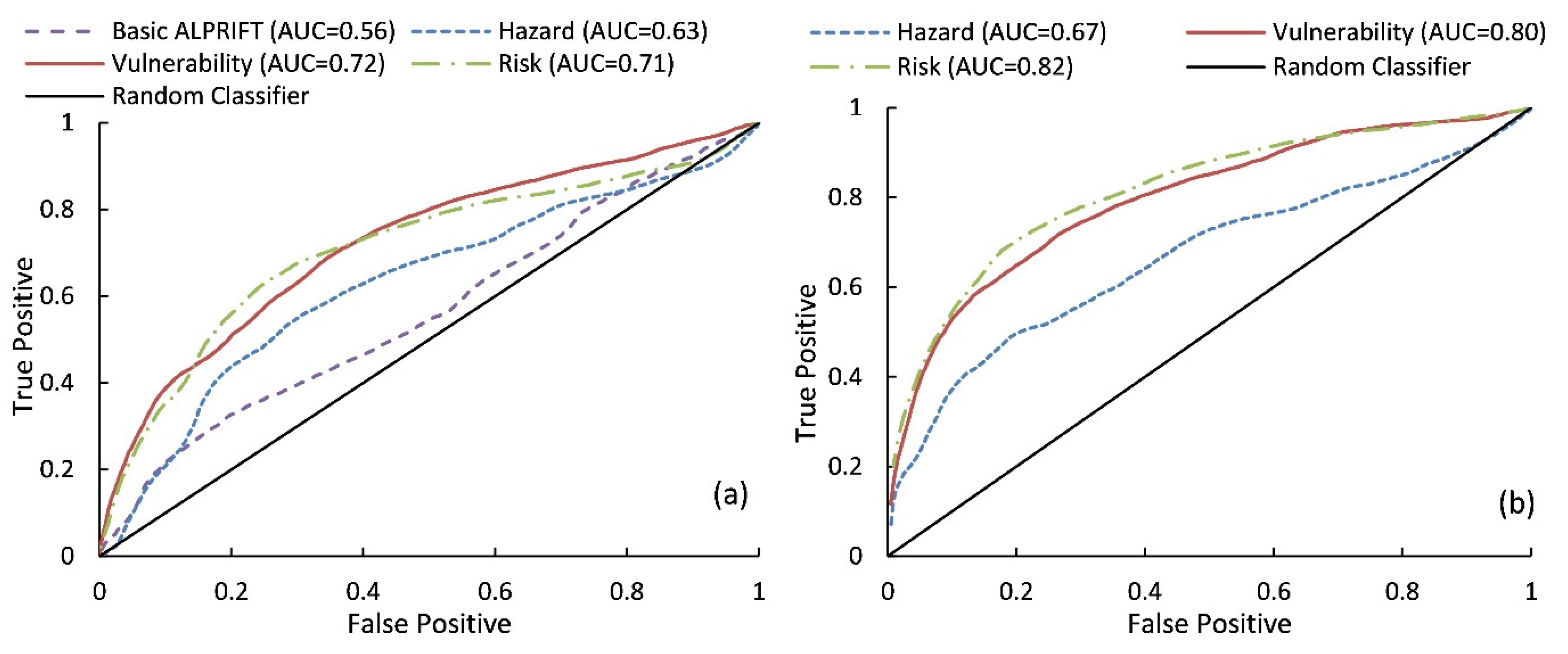
4.4. Evaluation of Results in Terms of ROC and AUC
5. Discussion
6. Conclusions
Author Contributions
Funding
Institutional Review Board Statement
Informed Consent Statement
Data Availability Statement
Conflicts of Interest
References
- Jhariya, D.C.; Kumar, T.; Pandey, H.K.; Kumar, S.; Kumar, D.; Gautam, A.K.; Kishore, N. Assessment of groundwater vulnerability to pollution by modified DRASTIC model and analytic hierarchy process. Environ. Earth Sci. 2019, 78, 1–20. [Google Scholar] [CrossRef]
- Garewal, S.K.; Vasudeo, A.D.; Landge, V.S.; Ghare, A.D. A GIS-based Modified DRASTIC (ANP) method for assessment of groundwater vulnerability: A case study of Nagpur city, India. Water Qual. Res. 2015, 52, 121–135. [Google Scholar] [CrossRef]
- Andualem, T.G.; Demeke, G.G. Groundwater potential assessment using GIS and remote sensing: A case study of Guna tana landscape, upper blue Nile Basin, Ethiopia. J. Hydrol. Reg. Stud. 2019, 24, 100610. [Google Scholar] [CrossRef]
- Sadeghfam, S.; Hassanzadeh, Y.; Nadiri, A.A.; Zarghami, M. Localization of groundwater vulnerability assessment using catastrophe theory. Water Resour. Manag. 2016, 30, 4585–4601. [Google Scholar] [CrossRef]
- Sadeghfam, S.; Khatibi, R.; Daneshfaraz, R.; Rashidi, H.B. Transforming vulnerability indexing for saltwater intrusion into risk indexing through a fuzzy catastrophe scheme. Water Resour. Manag. 2020, 34, 175–194. [Google Scholar] [CrossRef]
- Sadeghfam, S.; Khatibi, R.; Dadashi, S.; Nadiri, A.A. Transforming subsidence vulnerability indexing based on ALPRIFT into risk indexing using a new fuzzy-catastrophe scheme. Environ. Impact Assess. Rev. 2020, 82, 106352. [Google Scholar] [CrossRef]
- Band, S.S.; Janizadeh, S.; Pal, S.C.; Chowdhuri, I.; Siabi, Z.; Norouzi, A.; Mosavi, A. Comparative analysis of artificial intelligence models for accurate estimation of groundwater nitrate concentration. Sensors 2020, 20, 5763. [Google Scholar] [CrossRef] [PubMed]
- Nguyen, P.T.; Ha, D.H.; Jaafari, A.; Nguyen, H.D.; Van Phong, T.; Al-Ansari, N.; Pham, B.T. Groundwater potential mapping combining artificial neural network and real AdaBoost ensemble technique: The DakNong province case-study, Vietnam. Int. J. Environ. Res. Public Health 2020, 17, 2473. [Google Scholar] [CrossRef] [Green Version]
- Moazamnia, M.; Hassanzadeh, Y.; Nadiri, A.A.; Sadeghfam, S. Vulnerability indexing to saltwater intrusion from models at two levels using artificial intelligence multiple model (AIMM). J. Environ. Manag. 2020, 255, 109871. [Google Scholar] [CrossRef] [PubMed]
- Sadeghfam, S.; Nourbakhsh Khiyabani, F.; Khatibi, R.; Daneshfaraz, R. A study of land subsidence problems by ALPRIFT for vulnerability indexing and risk indexing and treating subjectivity by strategy at two levels. J. Hydroinform. 2020, 22, 1640–1662. [Google Scholar] [CrossRef]
- Gharekhani, M.; Nadiri, A.A.; Khatibi, R.; Sadeghfam, S. An investigation into time-variant subsidence potentials using inclusive multiple modelling strategies. J. Environ. Manag. 2021, 294, 112949. [Google Scholar] [CrossRef] [PubMed]
- Nadiri, A.A.; Taheri, Z.; Khatibi, R.; Barzegari, G.; Dideban, K. Introducing a new framework for mapping subsidence vulnerability indices (SVIs): ALPRIFT. Sci. Total Environ. 2018, 628, 1043–1057. [Google Scholar] [CrossRef] [PubMed]
- Arabameri, A.; Pal, S.C.; Rezaie, F.; Chakrabortty, R.; Chowdhuri, I.; Blaschke, T.; Ngo, P.T.T. Comparison of multi-criteria and artificial intelligence models for land-subsidence susceptibility zonation. J. Environ. Manag. 2021, 284, 112067. [Google Scholar] [CrossRef] [PubMed]
- Ebrahimy, H.; Feizizadeh, B.; Salmani, S.; Azadi, H. A comparative study of land subsidence susceptibility mapping of Tasuj plane, Iran, using boosted regression tree, random forest and classification and regression tree methods. Environ. Earth Sci. 2020, 79, 1–12. [Google Scholar] [CrossRef]
- Nadiri, A.A.; Khatibi, R.; Khalifi, P.; Feizizadeh, B. A study of subsidence hotspots by mapping vulnerability indices through innovatory ‘ALPRIFT’ using artificial intelligence at two levels. Bull. Eng. Geol. Environ. 2020, 79, 3989–4003. [Google Scholar] [CrossRef]
- Mohammady, M.; Pourghasemi, H.R.; Amiri, M. Assessment of land subsidence susceptibility in Semnan plain (Iran): A comparison of support vector machine and weights of evidence data mining algorithms. Nat. Hazards 2019, 99, 951–971. [Google Scholar] [CrossRef]
- Perrin, J.; Cartannaz, C.; Noury, G.; Vanoudheusden, E. A multicriteria approach to karst subsidence hazard mapping supported by weights-of-evidence analysis. Eng. Geol. 2015, 197, 296–305. [Google Scholar] [CrossRef]
- Pradhan, B.; Abokharima, M.H.; Jebur, M.N.; Tehrany, M.S. Land subsidence susceptibility mapping at Kinta Valley (Malaysia) using the evidential belief function model in GIS. Nat. Hazards 2014, 73, 1019–1042. [Google Scholar] [CrossRef]
- Abdollahi, S.; Pourghasemi, H.R.; Ghanbarian, G.A.; Safaeian, R. Prioritization of effective factors in the occurrence of land subsidence and its susceptibility mapping using an SVM model and their different kernel functions. Bull. Eng. Geol. Environ. 2019, 78, 4017–4034. [Google Scholar] [CrossRef]
- Rehman, S.; Sahana, M.; Dutta, S.; Sajjad, H.; Song, X.; Imdad, K.; Dou, J. Assessing subsidence susceptibility to coal mining using frequency ratio, statistical index and Mamdani fuzzy models: Evidence from Raniganj coalfield, India. Environ. Earth Sci. 2020, 79, 1–18. [Google Scholar] [CrossRef]
- Najafi, Z.; Pourghasemi, H.R.; Ghanbarian, G.; Shamsi, S.R.F. Land-subsidence susceptibility zonation using remote sensing, GIS, and probability models in a Google Earth Engine platform. Environ. Earth Sci. 2020, 79, 1–16. [Google Scholar] [CrossRef]
- Arabameri, A.; Saha, S.; Roy, J.; Tiefenbacher, J.P.; Cerda, A.; Biggs, T.; Collins, A.L. A novel ensemble computational intelligence approach for the spatial prediction of land subsidence susceptibility. Sci. Total Environ. 2020, 726, 138595. [Google Scholar] [CrossRef] [PubMed]
- Guoqing, Y.; Jingqin, M. D-InSAR technique for land subsidence monitoring. Earth Sci. Front. 2008, 15, 239–243. [Google Scholar] [CrossRef]
- Ge, L.; Ng, A.H.M.; Li, X.; Abidin, H.Z.; Gumilar, I. Land subsidence characteristics of Bandung Basin as revealed by ENVISAT ASAR and ALOS PALSAR interferometry. Remote Sens. Environ. 2014, 154, 46–60. [Google Scholar] [CrossRef]
- Chaussard, E.; Wdowinski, S.; Cabral-Cano, E.; Amelung, F. Land subsidence in central Mexico detected by ALOS InSAR time-series. Remote Sens. Environ. 2014, 140, 94–106. [Google Scholar] [CrossRef]
- Pacheco-Martínez, J.; Wdowinski, S.; Cabral-Cano, E.; Hernández-Marín, M.; Ortiz-Lozano, J.A.; Oliver-Cabrera, T.; Havazli, E. Application of InSAR and gravimetric surveys for developing construction codes in zones of land subsidence induced by groundwater extraction: Case study of Aguascalientes, Mexico. Proc. Int. Assoc. Hydrol. Sci. 2015, 372, 121–127. [Google Scholar] [CrossRef] [Green Version]
- Zuo, J.; Gong, H.; Chen, B.; Liu, K.; Zhou, C.; Ke, Y. Time-series evolution patterns of land subsidence in the eastern Beijing Plain, China. Remote Sens. 2019, 11, 539. [Google Scholar] [CrossRef] [Green Version]
- Jiang, H.; Balz, T.; Cigna, F.; Tapete, D. Land Subsidence in Wuhan Revealed Using a Non-Linear PSInSAR Approach with Long Time Series of COSMO-SkyMed SAR Data. Remote Sens. 2021, 13, 1256. [Google Scholar] [CrossRef]
- Chen, C.H.; Lin, Z.S. A committee machine with empirical formulas for permeability prediction. Comput. Geosci. 2006, 32, 485–496. [Google Scholar] [CrossRef]
- Kadkhodaie-Ilkhchi, A.; Rezaee, M.R.; Rahimpour-Bonab, H.; Chehrazi, A. Petrophysical data prediction from seismic attributes using committee fuzzy inference system. Comput. Geosci. 2009, 35, 2314–2330. [Google Scholar] [CrossRef] [Green Version]
- Swets, J.A. Measuring the accuracy of diagnostic systems. Science 1988, 240, 1285–1293. [Google Scholar] [CrossRef] [Green Version]
- UN Office for Disaster Risk ReductionLiving with Risk. A Global Review of Disaster Reduction Initiatives; United Nations Publications: Geneva, Switzerland, 2004; ISBN 9211010640. [Google Scholar]
- Hanssen, R.F. Radar Interferometry: Data Interpretation and Error Analysis; Kluwer Academic Publishers: Dordrecht, The Netherlands, 2001. [Google Scholar]
- Cheng, C.H.; Liu, Y.H.; Lin, Y. Evaluating a weapon system using catastrophe series based on fuzzy scales. In Soft Computing in Intelligent Systems and Information Processing, Proceedings of the 1996 Asian Fuzzy Systems Symposium, Kent-ing, Taiwan, 6 August 2002; IEEE: Piscataway, NJ, USA, 2002; pp. 212–217. [Google Scholar] [CrossRef]
- Zadeh, L.A. Fuzzy sets as a basis for a theory of possibility. Fuzzy Sets Syst. 1965, 338–353. [Google Scholar] [CrossRef]
- Thom, R. Stabilité structurelle et morphogénèse. Poetics 1974, 3, 7–19. [Google Scholar] [CrossRef]
- Gao, S.; Sun, H.; Zhao, L.; Wang, R.; Xu, M.; Cao, G. Dynamic assessment of island ecological environment sustainability under urbanization based on rough set, synthetic index and catastrophe progression analysis theories. Ocean Coast. Manag. 2019, 178, 104790. [Google Scholar] [CrossRef]
- Tian, Y.; Zheng, B.; Shen, H.; Zhang, S.; Wang, Y. A novel index based on the cusp catastrophe theory for predicting harmful algae blooms. Ecol. Indic. 2019, 102, 746–751. [Google Scholar] [CrossRef]
- Emberger, L. Climate on a formula applicable in botanical geography. Comptes Rendus L’académie Sci. 1930, 191, 389–390. [Google Scholar]
- East Azerbaijan Water Authority Provided the Data through Private Communications. Available online: http://www.azarwater.ir/?l=EN (accessed on 13 August 2021).
- Piscopo, G. Groundwater Vulnerability Map; Ex planatory Notes, Castlereagh Catchment, NSW; Department of Land and Water Conservation: Parramatta, Australia, 2001.


| Reference | Approach | Incorporated Data Layers |
|---|---|---|
| [18] | Statistical | Altitude, Slope, Aspect, Lithology, Distance from the fault, Distance from the river, Normalized difference vegetation index, Soil type, Stream power index, Topographic wetness index, Land use/Land cover |
| [17] | MCDM | Cover thickness, Low permeability layer thickness, Distance to losing streams, Saturated cover thickness |
| [19] | AI | Percentage slope, Slope aspect, Altitude, Profile curvature, Plan curvature, Topographic wetness index, Distance from river, Lithological, Units, Piezometric data, Land use, Normalized difference vegetation index |
| [16] | AI | Elevation, Slope angle, Slope aspect, Topographic wetness index, Plan curvature, Profile curvature, Lithology, Land use, Drainage network, Roads, Faults, Groundwater table |
| [20] | AI | Geology, Lineament, Land use/Land cover, Rainfall distribution, Slope, Slope aspect, Coal seam proximity, Curvature, Distance from road, Drainage density, Drainage proximity, Elevation, Soil, Stream power index, Topographical wetness index |
| [21] | Statistical | Altitude, Slope aspect, Land use, Distance from the faults, Lithology, Plan curvature, Distance from river, Slope percent, Piezometric data, Topographic wetness index |
| [22] | AI | Groundwater drawdown, Land use/Land cover, Elevation, Lithology, Drainage density, Distance to stream, Distance to road, Slope, Topographical Wetness index, Profile curvature, Aspect, Plan curvature |
| [14] | AI and MCDM | Altitude, Slope angle, Aspect, Groundwater level, Groundwater level change, Land cover, Lithology, Distance to fault, Distance to stream, Stream power index, Topographic wetness index, Plan curvature |
| [13] | AI and MCDM | Lithology, Plan Curvature, Profile Curvature, Slope, Topographical Wetness Index, Aspect, Elevation, Drainage Density, Distance to road, Distance to stream, Groundwater, Land Use/land Cover |
| Data Layer | Input Dataset | Processing | |
|---|---|---|---|
| Hazard | Pumping of groundwater (P) | Annual discharge at abstraction wells | Draw Thiessen polygon Interpolate by Inverse Distance Weighted (IDW) technique |
| Water Table decline trend (T) | GWL time series | Calculate trend of decline Interpolate by IDW | |
| Vulnerability | Aquifer media (A) | Geological logs | Assign ALPRIFT rates Interpolate by IDW |
| Land use (L) | Satellite image (Sentinel-1) | Image Processing | |
| Recharge (R) | Slope Soil permeability Precipitation | Reclassify Overlay [31] | |
| Impact of aquifer thickness (I) | Geoelectric profiles | Interpolate by IDW | |
| Fault distance (F) | Fault map | Euclidean distance tool |
| Name | State Variable | Control Parameter | Catastrophe Fuzzy Membership Functions |
|---|---|---|---|
| Fold | 1 | 1 | |
| Cusp | 1 | 2 | |
| Swallowtail | 1 | 3 | |
| Butterfly | 1 | 4 | , |
| Wigwam | 1 | 5 | , , |
| R2 | RMSE | |||||
|---|---|---|---|---|---|---|
| Training | Testing | Total | Training | Testing | Total | |
| Hazard | 0.71 | 0.70 | 0.71 | 0.026 | 0.026 | 0.45 |
| Vulnerability | 0.72 | 0.72 | 0.72 | 0.029 | 0.028 | 0.44 |
| Risk | 0.74 | 0.74 | 0.74 | 0.027 | 0.027 | 0.48 |
Publisher’s Note: MDPI stays neutral with regard to jurisdictional claims in published maps and institutional affiliations. |
© 2021 by the authors. Licensee MDPI, Basel, Switzerland. This article is an open access article distributed under the terms and conditions of the Creative Commons Attribution (CC BY) license (https://creativecommons.org/licenses/by/4.0/).
Share and Cite
Nadiri, A.A.; Moazamnia, M.; Sadeghfam, S.; Barzegar, R. Mapping Risk to Land Subsidence: Developing a Two-Level Modeling Strategy by Combining Multi-Criteria Decision-Making and Artificial Intelligence Techniques. Water 2021, 13, 2622. https://doi.org/10.3390/w13192622
Nadiri AA, Moazamnia M, Sadeghfam S, Barzegar R. Mapping Risk to Land Subsidence: Developing a Two-Level Modeling Strategy by Combining Multi-Criteria Decision-Making and Artificial Intelligence Techniques. Water. 2021; 13(19):2622. https://doi.org/10.3390/w13192622
Chicago/Turabian StyleNadiri, Ata Allah, Marjan Moazamnia, Sina Sadeghfam, and Rahim Barzegar. 2021. "Mapping Risk to Land Subsidence: Developing a Two-Level Modeling Strategy by Combining Multi-Criteria Decision-Making and Artificial Intelligence Techniques" Water 13, no. 19: 2622. https://doi.org/10.3390/w13192622
APA StyleNadiri, A. A., Moazamnia, M., Sadeghfam, S., & Barzegar, R. (2021). Mapping Risk to Land Subsidence: Developing a Two-Level Modeling Strategy by Combining Multi-Criteria Decision-Making and Artificial Intelligence Techniques. Water, 13(19), 2622. https://doi.org/10.3390/w13192622