
Laying the Groundwork for Raising Awareness on Water Related Issues with a Socio-Hydrogeological Approach: The Inle Lake Case Study (Southern Shan State, Myanmar)

 ,
,  , and
, and
Abstract
:1. Introduction
2. Materials and Method
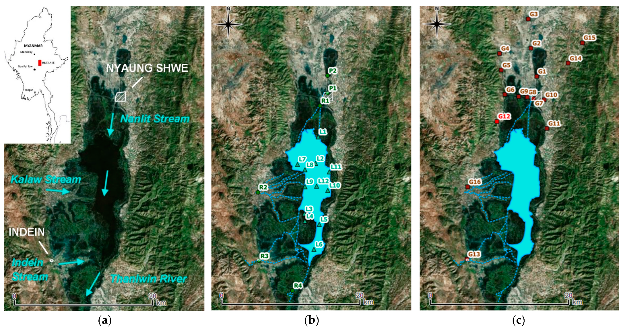
2.1. Study Area
2.2. Hydrogeochemical Assessment
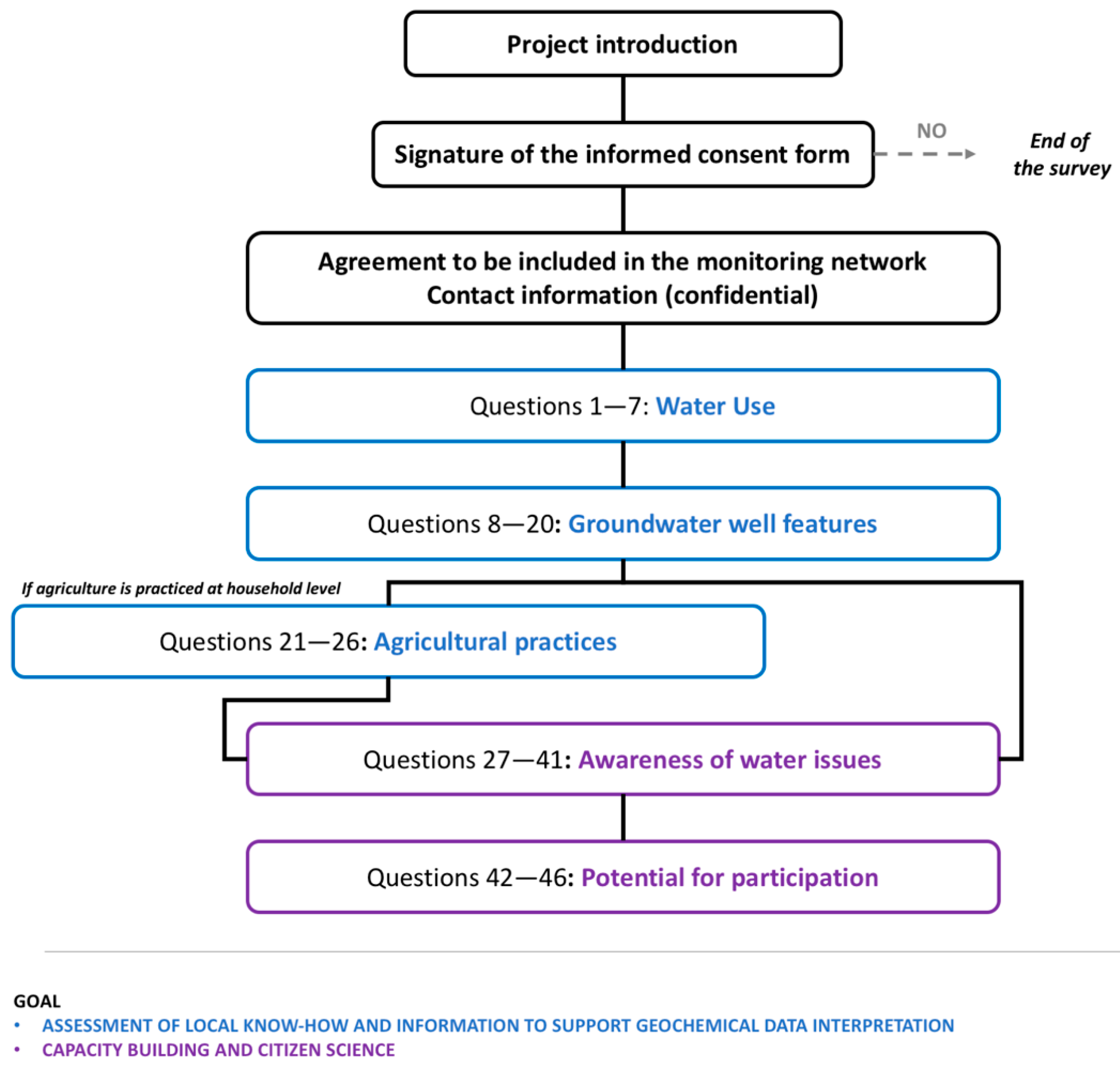
2.3. Public Engagement
3. Results
3.1. Surface and Groundwater Quality
3.1.1. Major Ions
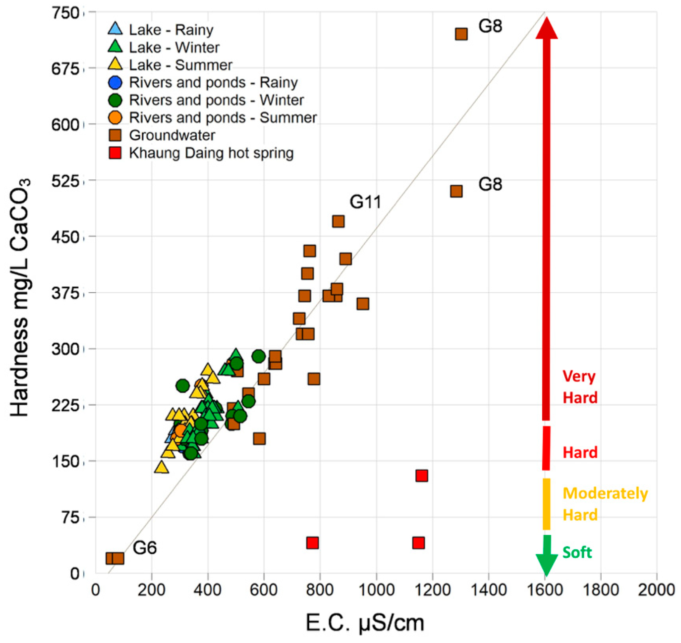
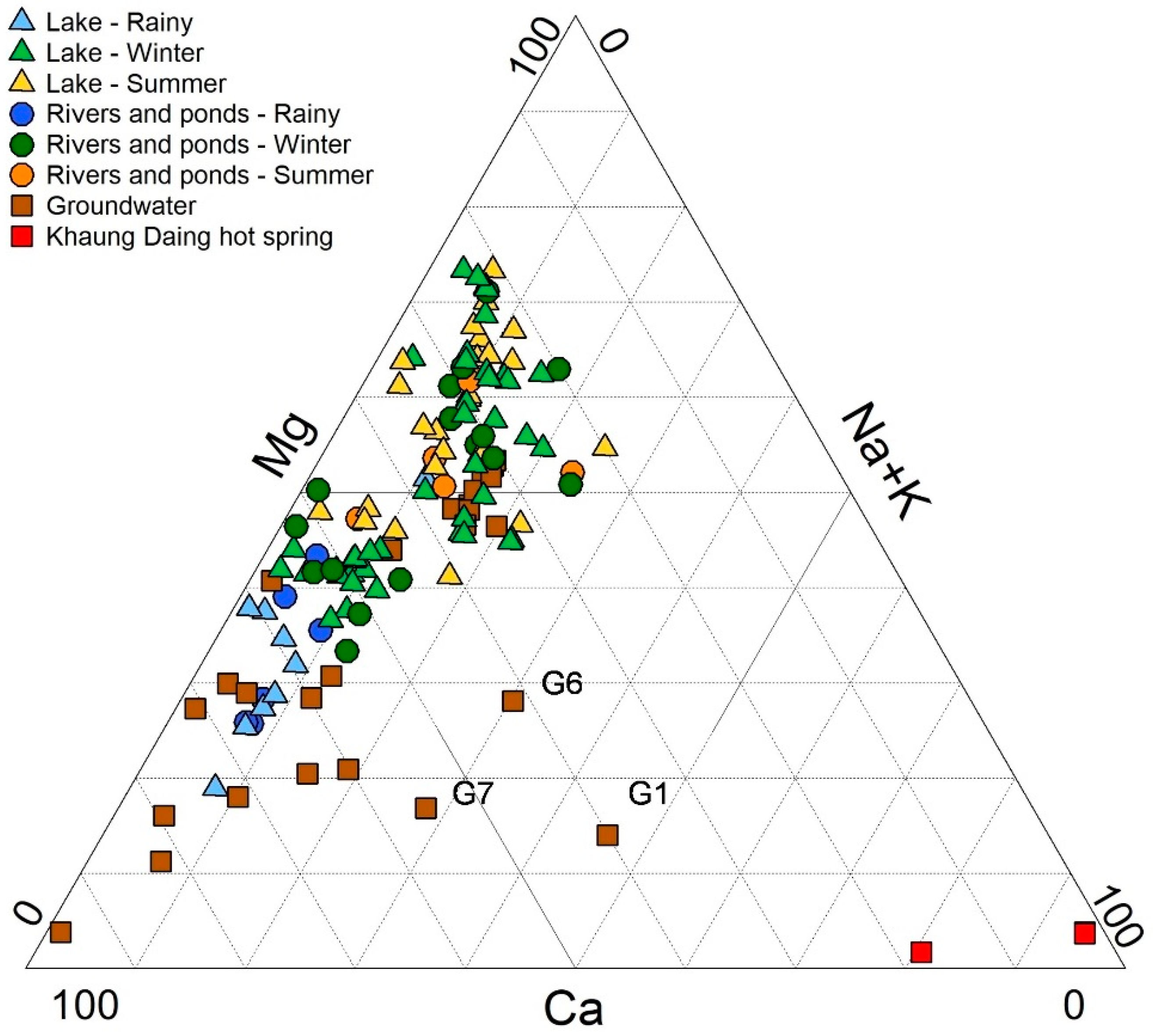
- Surface waters are dominantly of Ca(Mg) type in the rainy season, and shift to Mg(Ca) type in winter and in summer.
- Groundwater is mostly of Ca or Ca(Mg) type. However, some samples (G6, G7, and G1) show an increased amount of Na + K that exceeds 25%.
- The Khaung Daing hot spring (G12) is instead of Na + K type.
3.1.2. Nutrients
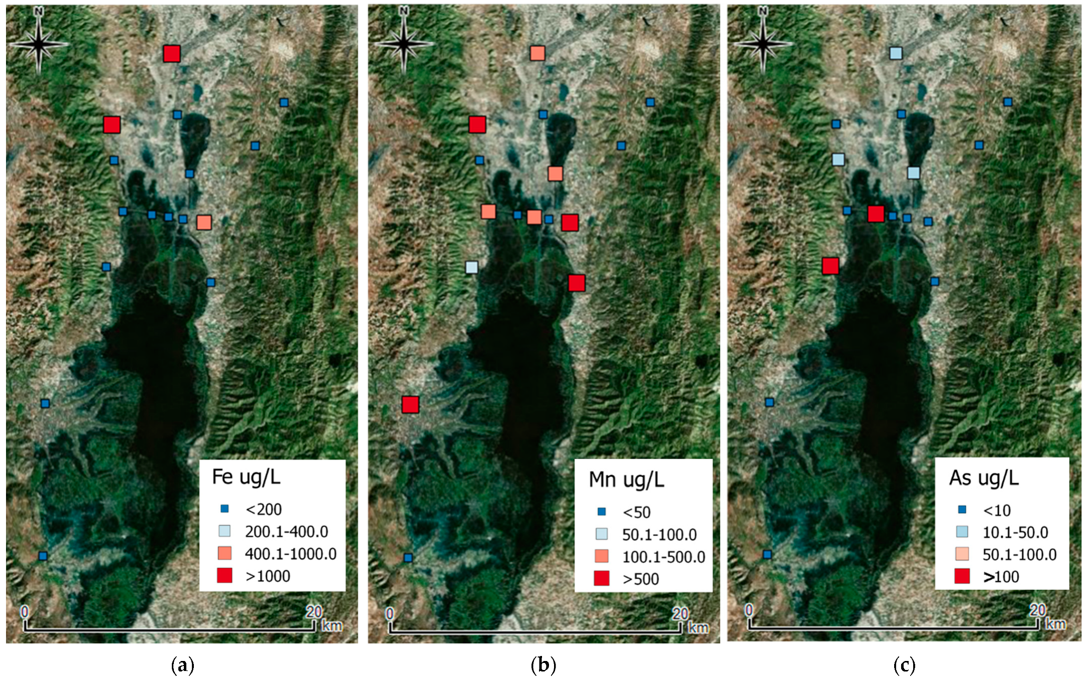
3.1.3. Trace Metals
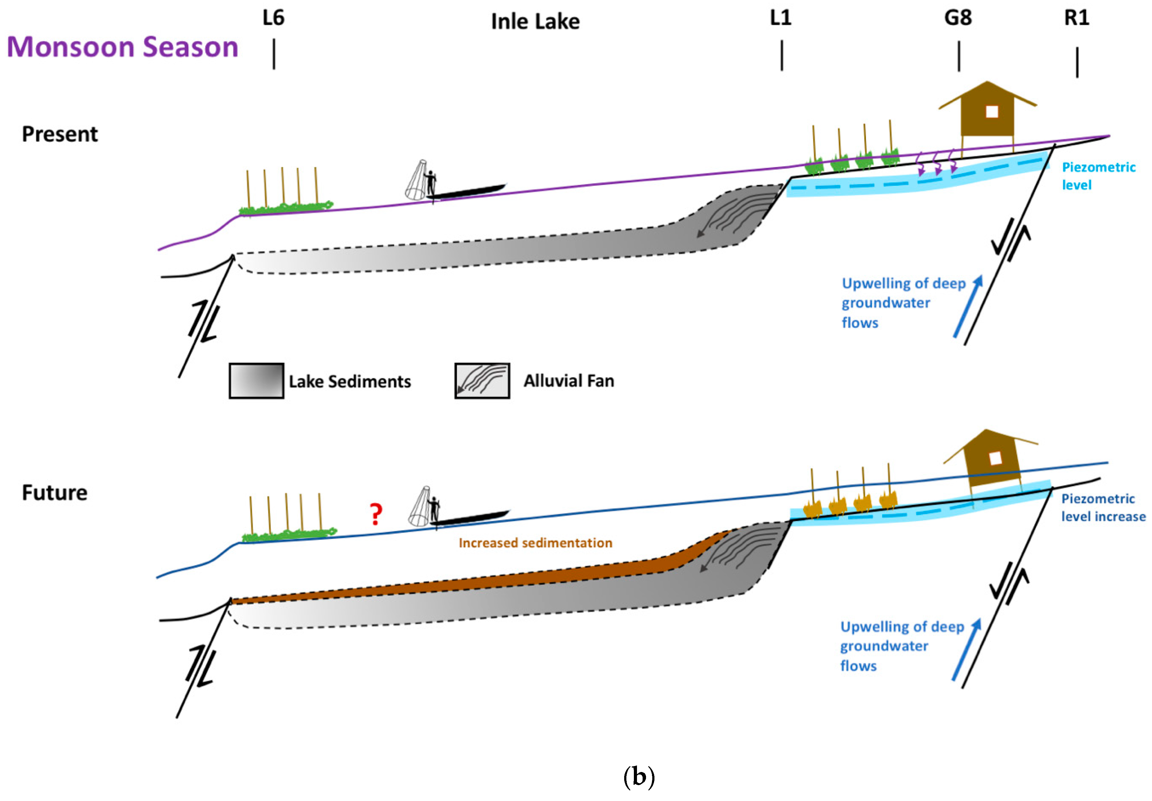
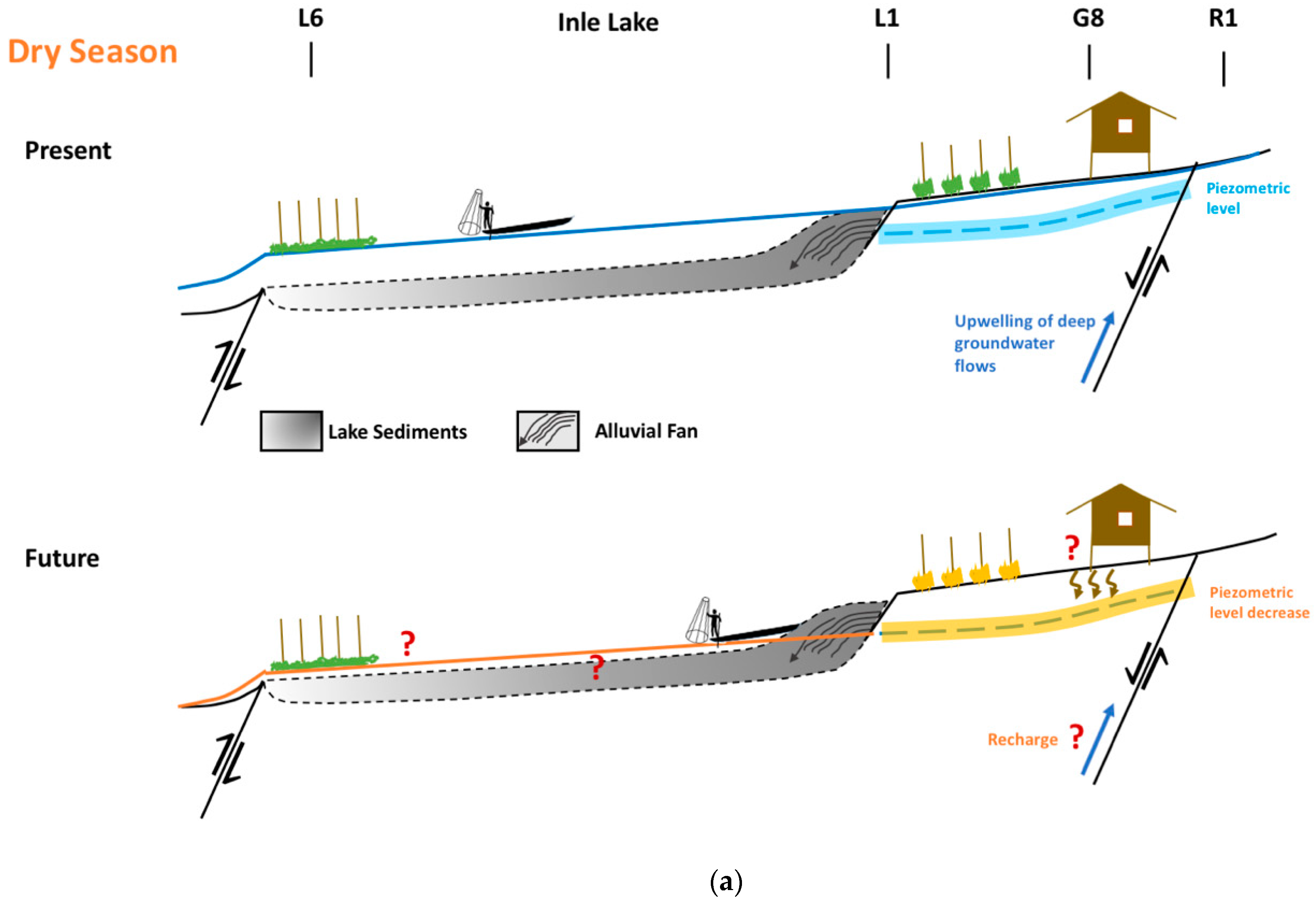
3.2. Hydrodynamics
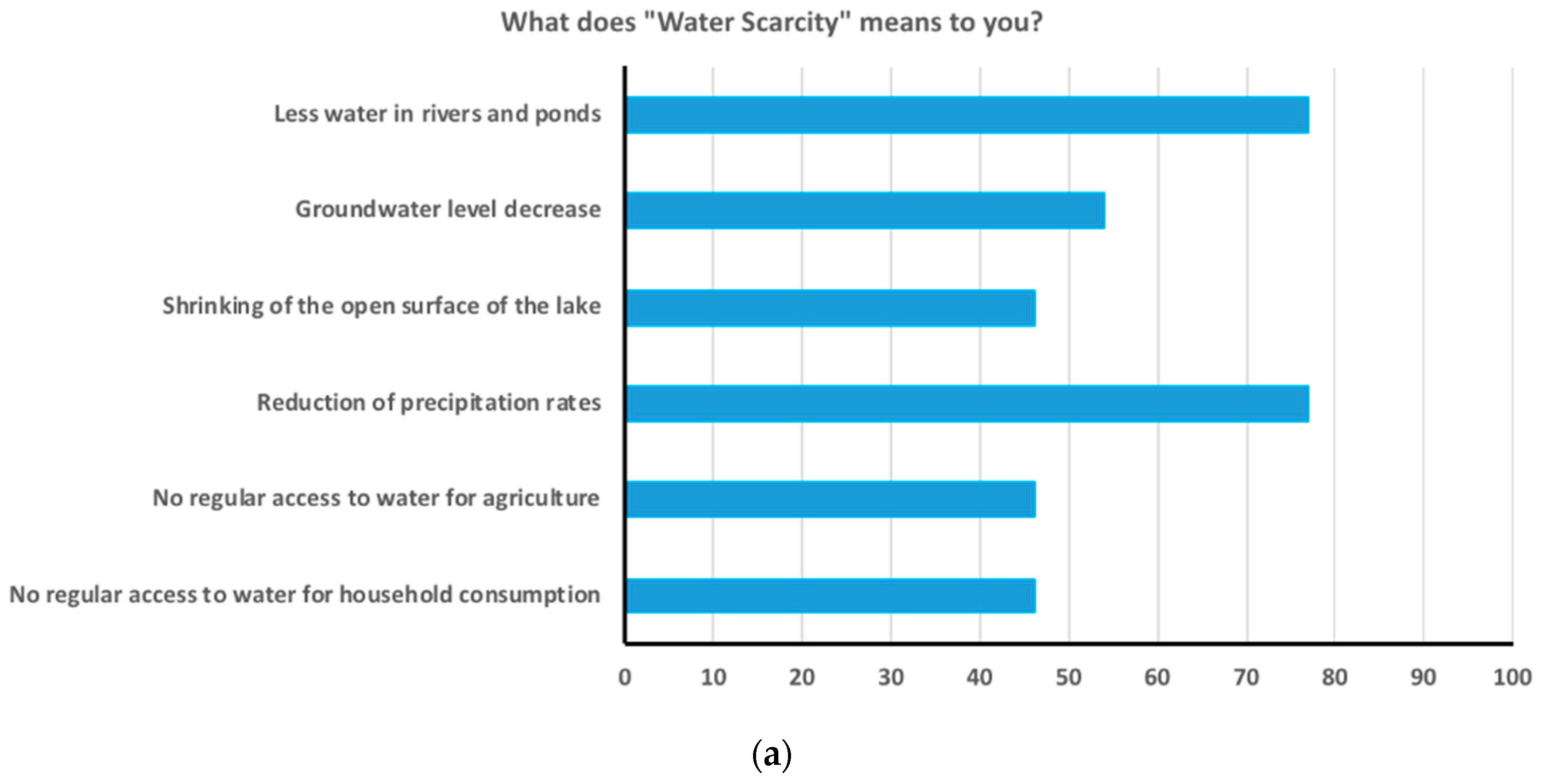
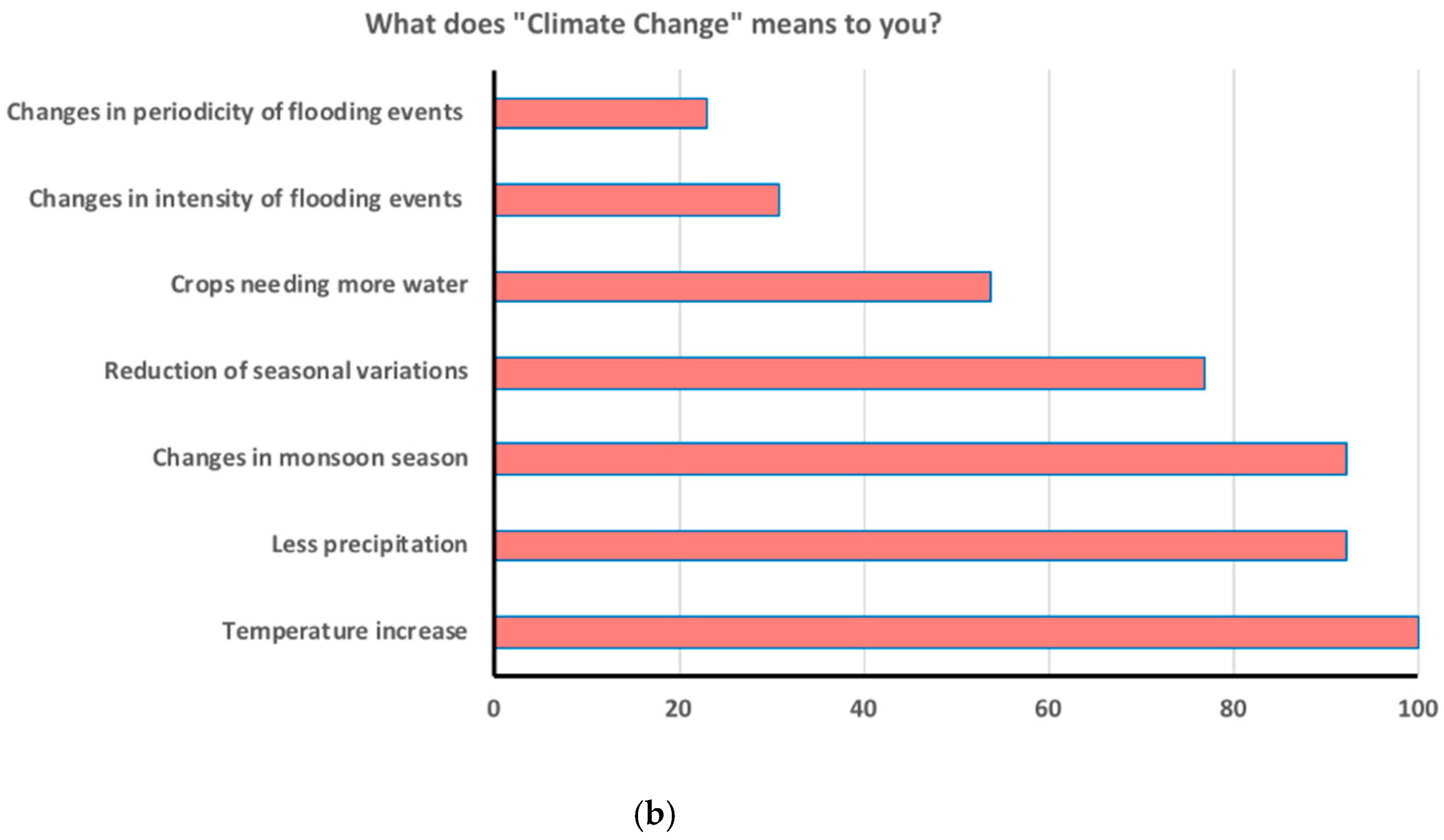
3.3. Assesment of Local Know-How and Public Participation Potential
4. Discussion
4.1. Emerging Criticalities from a Scientific Perspective
4.2. Public Engagement
4.3. Percieved Criticalities by Locals and Geochemical Evidences
4.4. How to Translate Scientific Outcomes into Shared Actions for Groundwater Protection?
5. Conclusions
Supplementary Materials
Author Contributions
Funding
Institutional Review Board Statement
Informed Consent Statement
Data Availability Statement
Acknowledgments
Conflicts of Interest
References
- UN Water Progress on Integrated Water Resources Management—Global Baseline for SDG Indicator 6.5. Available online: https://www.unwater.org/publications/progress-on-integrated-water-resources-management-651/ (accessed on 10 June 2021).
- United Nations. The Sustainable Development Goals Report 2019; United Nations Publication Issued by the Department of Economic and Social Affairs, 64; Available online: https://undocs.org/E/2019/68 (accessed on 26 January 2021).
- Human-Rights Based Approach to IWRM: Training Manual and Facilitator’s Guide—Stockholm International Water Institute. Available online: https://www.siwi.org/human-rights-based-approach-iwrm-training-manual-facilitators-guide/ (accessed on 26 January 2021).
- Myanmar|WaterAid US. Available online: https://www.wateraid.org/us/where-we-work/myanmar (accessed on 26 January 2021).
- Nesheim, I.; Wathne, B.M.; Ni, B.; Tun, Z.L. Myanmar: Pilot introducing the national water framework directiv. GWF Wasser Abwasser 2016, 157, 18–27. [Google Scholar]
- UN Water Country (Or Area)|SDG 6 Data. Available online: https://www.sdg6data.org/country-or-area/Myanmar (accessed on 25 January 2021).
- Lwin, K.K.; Pal, I.; Shrestha, S.; Warnitchai, P. Assessing social resilience of flood-vulnerable communities in Ayeyarwady Delta, Myanmar. Int. J. Disaster Risk Reduct. 2020, 51, 101745. [Google Scholar] [CrossRef]
- Flor, R.J.; Maat, H.; Leeuwis, C.; Singleton, G.; Gummert, M. Adaptive Research with and without a Learning Alliance in Myanmar: Differences in learning process and agenda for participatory research. NJAS Wagening. J. Life Sci. 2017, 81, 33–42. [Google Scholar] [CrossRef]
- Castelli, G.; Oo, W.M.; di Maggio, A.; Fellin, L.; Re, V.; Bresci, E. Participatory analysis of sustainable land and water management practices for integrated rural development in Myanmar. J. Water Sanit. Hyg. Dev. 2020, 11, 26–36. [Google Scholar] [CrossRef]
- Dore, J.; Lebel, L.; Molle, F. A framework for analysing transboundary water governance complexes, illustrated in the Mekong Region. J. Hydrol. 2012, 466–467, 23–36. [Google Scholar] [CrossRef]
- Götz, J.M. Contested Water Governance in Myanmar/Burma: Politics, the Peace Negotiations and the Production of Scale; Springer: Cham, Switzerland, 2019; pp. 87–106. [Google Scholar]
- Karki, S.; Thandar, A.M.; Uddin, K.; Tun, S.; Aye, W.M.; Aryal, K.; Kandel, P.; Chettri, N. Impact of land use land cover change on ecosystem services: A comparative analysis on observed data and people’s perception in Inle Lake, Myanmar. Environ. Syst. Res. 2018, 7, 25. [Google Scholar] [CrossRef] [Green Version]
- Malaysian Institute for Integrated Development. Destination Management Plan for the Inlay Lake Region 2014–2019. Ministry of Hotels and Tourism the Republic of the Union of Myanmar Destination Management Plan for the Inlay Lake Region 2. Available online: https://www.mmiid.org/publication/destination-management-plan-inlay-lake-region (accessed on 10 June 2021).
- Re, V. Incorporating the social dimension into hydrogeochemical investigations for rural development: The Bir Al-Nas approach for socio-hydrogeology. Hydrogeol. J. 2015, 23, 1293–1304. [Google Scholar] [CrossRef] [Green Version]
- Re, V. Socio-hydrogeology and Geoethics—State of the Art and Future Challenges. Adv. Sci. Technol. Innov. 2021, 373–376. [Google Scholar] [CrossRef]
- Myanmar Water Portal Hydrogeochemical and Socio-Hydrogeological Assessment of the Inle Lake Catchment (Southern Shan State Myanmar)—Myanmar Water Portal. Available online: https://www.myanmarwaterportal.com/news/2445-hydrogeochemical-and-socio-hydrogeological-assessment-of-the-inle-lake-catchment-southern-shan-state-myanmar.html (accessed on 14 June 2021).
- Michalon, M.; Gunnell, Y.; Lejot, J.; Mialhe, F.; Aung, T. Accelerated degradation of Lake Inle (Myanmar): A baseline study for environmentalists and developers. Land Degrad. Dev. 2019, 30, 928–941. [Google Scholar] [CrossRef]
- Crosetto, S.; Watkinson, I.M.; Min, S.; Gori, S.; Falcucci, E.; Le Ngal, N. Evidence of Quaternary and recent activity along the Kyaukkyan Fault, Myanmar. J. Asian Earth Sci. 2018, 156, 207–225. [Google Scholar] [CrossRef]
- Oo, T.; Hlaing, T.; Htay, N. Permian of Myanmar. J. Asian Earth Sci. 2002, 20, 683–689. [Google Scholar] [CrossRef]
- Ya, K.Z.; Otake, T.; Koide, A.; Sanematsu, K.; Sato, T. Geochemical characteristics of ores and surface waters for environmental risk assessment in the Pinpet iron deposit, southern Shan State, Myanmar. Resour. Geol. 2020, 70, 296–308. [Google Scholar] [CrossRef] [Green Version]
- Wang, Y.; Sieh, K.; Tun, S.T.; Lai, K.Y.; Myint, T. Active tectonics and earthquake potential of the Myanmar region. J. Geophys. Res. Solid Earth 2014, 119, 3767–3822. [Google Scholar] [CrossRef]
- Htwe, T.N.; Kywe, M.; Buerkert, A.; Brinkmann, K. Transformation processes in farming systems and surrounding areas of Inle Lake, Myanmar, during the last 40 years. J. Land Use Sci. 2015, 10, 205–223. [Google Scholar] [CrossRef]
- Htwe, T.N.; Brinkmann, K.; Buerkert, A. Spatio-temporal assessment of soil erosion risk in different agricultural zones of the Inle Lake region, southern Shan State, Myanmar. Environ. Monit. Assess. 2015, 187, 1–14. [Google Scholar] [CrossRef]
- Su, M.; Jassby, A.D. Inle: A large Myanmar lake in transition. Lakes Reserv. Res. Manag. 2000, 5, 49–54. [Google Scholar] [CrossRef]
- Kottek, M.; Grieser, J.; Beck, C.; Rudolf, B.; Rubel, F. World map of the Köppen-Geiger climate classification updated. Meteorol. Z. 2006, 15, 259–263. [Google Scholar] [CrossRef]
- Thin, M.M.; Sacchi, E.; Setti, M. Hydrological processes at Inle Lake (Southern Shan State, Myanmar) inferred from hydrochemical, mineralogical and isotopic data. Isoto. Environ. Health Stud. 2016, 52, 455–467. [Google Scholar] [CrossRef] [PubMed]
- Thin, M.M.; Re, V.; Sacchi, E.; Allais, E.; Thin, M.M.; Re, V.; Sacchi, E.; Allais, E. Tracing surface water dynamics and groundwater recharge at Inle Lake (Southern Shan State, Myanmar) using stable water isotopes. In Proceedings of the International Symposium on Isotope Hydrology—Advancing the Understanding of Water Cycle Processes, CN-271, Vienna, Austria, 20–24 May 2019. [Google Scholar]
- Re, V.; Thin, M.M.; Setti, M.; Comizzoli, S.; Sacchi, E. Present status and future criticalities evidenced by an integrated assessment of water resources quality at catchment scale: The case of Inle Lake (Southern Shan state, Myanmar). Appl. Geochem. 2018, 92, 82–93. [Google Scholar] [CrossRef]
- Thin, M.M.; Sacchi, E.; Setti, M.; Re, V. A Dual Source of Phosphorus to Lake Sediments Indicated by Distribution, Content, and Speciation: Inle Lake (Southern Shan State, Myanmar). Water 2020, 12, 1993. [Google Scholar] [CrossRef]
- Thin, M.M.; Setti, M.; Sacchi, E.; Re, V.; Riccardi, M.P.; Allais, E. Mineralogical and geochemical characterisation of alkaline lake sediments to trace origin, depositional processes, and anthropogenic impacts: Inle Lake (Southern Shan State, Myanmar). Environ. Earth Sci. 2020, 79, 1–18. [Google Scholar] [CrossRef]
- van Meel, P.; Leewis, M.; Tonneijck, M.; Leushuis, M.; de Groot, K.; de Jongh, I.; Laboyrie, H.; Graas, S.; Shubber, Z.; Klink, T.; et al. Myanmar Integrated Water Resources Management Strategic Study. Available online: https://docplayer.net/13558357-Myanmar-integrated-water-resources-management-strategic-study.html (accessed on 28 January 2021).
- The Myanmar Times IFC, Agriculture Department Institute GAP in Inle Lake. Available online: https://www.mmtimes.com/business/27228-ifc-agriculture-department-institute-gap-in-inle-lake.html (accessed on 29 July 2021).
- Michalon, M. Tourism(s) and the way to democracy in Myanmar. Asian J. Tour. Res. 2017, 2, 150–174. [Google Scholar] [CrossRef]
- Oo, U.M. Personal communication. 2021. [Google Scholar]
- Sacchi, E.; Re, V.; Setti, M.; Thin, M.M.; Di Sipio, E. Hydrochemical and Isotopic Features of the Khaung Daing Hot Spring (Inle lake, Southern Shan State, Myanmar). Procedia Earth Planet. Sci. 2017, 17, 750–753. [Google Scholar] [CrossRef]
- Thin, M.M. Environmental Applications of Physical Nuclear and Geochemical Techniques: Origin, Dynamics and Impact of Phosphates and Heavy Metals in Cultivated Areas and at Inle Lake, Myanmar. Ph.D. Thesis, University of Mandalay (Myanmar), Myanmar, Mainland, 2015. [Google Scholar]
- Thin, M.M.; Sacchi, E.; Setti, M. Geochemical and Mineralogical Composition of Grab and Core Sediments from Inle Lake (Southern Shan State, Myanmar). Available online: https://doi.pangaea.de/10.1594/PANGAEA.908284 (accessed on 11 June 2020).
- Johnes, P.J.; Heathwaite, A.L. A procedure for the simultaneous determination of total nitrogen and total phosphorus in freshwater samples using persulphate microwave digestion. Water Res. 1992, 26, 1281–1287. [Google Scholar] [CrossRef]
- Murphy, J.; Riley, J.P. A modified single solution method for the determination of phosphate in natural waters. Anal. Chim. Acta 1962, 27, 31–36. [Google Scholar] [CrossRef]
- Simler, R. Diagrammes: Logiciel d’Hydrochimie, Version 6.75. Available online: http://www.lha.univ-avignon.fr/LHA-Logiciels.htm (accessed on 30 August 2021).
- QGIS Development Team QGIS Geographic Information System. Open Source Geospatial Foundation Project—Version 2.2.0 2014. Available online: https://qgis.org/en/site/about/index.html (accessed on 30 August 2021).
- Sacchi, E.; Comizzoli, S.; Di Sipio, E.; Re, V.; Rotiroti, M.; Setti, M.; Thin, M.M. The Khaung Daing hot spring (Inle lake, Southern Shan State, Myanmar): Development opportunities and challenges. E3S Web Conf. 2019, 98, 09027. [Google Scholar] [CrossRef]
- OOPEC. Council directive 98/83/EC of 3 November 1998 on the quality of water intended for human consumption. Off. J. Eur. Communities 1998, 330, 32–54. [Google Scholar]
- Rozanski, K.; Araguás-Araguás, L.; Gonfiantini, R. Isotopic Patterns in Modern Global Precipitation. Geophys. Monogr. Union 2013, 1–36. [Google Scholar] [CrossRef]
- Global Network of Isotopes in Precipitation (GNIP)|IAEA. Available online: https://www.iaea.org/services/networks/gnip (accessed on 20 July 2021).
- Fritz, P.; Ian, D. Environmental Isotopes in Hydrogeology; CRC Press: Boca Raton, FL, USA, 2013; ISBN 1566702496. [Google Scholar]
- Sidle, R.C.; Ziegler, A.D.; Vogler, J.B. Contemporary changes in open water surface area of Lake Inle, Myanmar. Sustain. Sci. 2007, 2, 55–65. [Google Scholar] [CrossRef]
- Okamoto, I. Coping and Adaptation against Decreasing Fish Resources: Case Study of Fishermen in Lake Inle, Myanmar; IDE Discussion Paper; 2012; Institute of Developing Economies, Japan External Trade Organization (IDE-JETRO); Available online: https://www.ide.go.jp/English/Publish/Reports/Dp/329.html (accessed on 30 August 2021).
- Kyaw, K.T.W.; Ota, T.; Mizoue, N. Geographical Factors Trump Community Factors in Deforestation Risk in Two Watershed Conservation Forests in Myanmar. Forests 2021, 12, 541. [Google Scholar] [CrossRef]
- Biswas, S.; Vadrevu, K.P.; Mon, M.S.; Justice, C. Contemporary forest loss in Myanmar: Effect of democratic transition and subsequent timber bans on landscape structure and composition. Ambio 2021, 50, 914–928. [Google Scholar] [CrossRef]
- Supharatid, S.; Nafung, J.; Aribarg, T. Projected changes in temperature and precipitation over mainland Southeast Asia by CMIP6 models. J. Water Clim. Chang. 2021, 47, 47–69. [Google Scholar] [CrossRef]
- Shrestha, S.; Imbulana, N.; Piman, T.; Chonwattana, S.; Ninsawat, S.; Babur, M. Multimodelling approach to the assessment of climate change impacts on hydrology and river morphology in the Chindwin River Basin, Myanmar. Catena 2020, 188, 104464. [Google Scholar] [CrossRef]
- Sirisena, T.A.J.G.; Maskey, S.; Bamunawala, J.; Ranasinghe, R. Climate Change and Reservoir Impacts on 21st-Century Streamflow and Fluvial Sediment Loads in the Irrawaddy River, Myanmar. Front. Earth Sci. 2021, 9, 107. [Google Scholar] [CrossRef]
- Kreft, S.; Eckstein, D.; Dorsch, L.; Fischer, L. GLOBAL CLIMATE RISK INDEX 2016 Who Suffers Most from Extreme Weather Events? Available online: https://germanwatch.org/sites/default/files/publication/16411.pdf (accessed on 10 June 2021).
- Pradhan, N.; Habib, H.; Venkatappa, M.; Ebbers, T.; Duboz, R.; Shipin, O. Framework tool for a rapid cumulative effects assessment: Case of a prominent wetland in Myanmar. Environ. Monit. Assess. 2015, 187, 1–18. [Google Scholar] [CrossRef]
- Perrone, U.; Facchinelli, A.; Sacchi, E. Phosphorus dynamics in a small eutrophic Italian lake. Water Air Soil Pollut. 2008, 189, 335–351. [Google Scholar] [CrossRef]
- MoECAF Long Term Restoration and Conservation Plan for Inle Lake; 2014; pp. 1–138. Available online: https://unhabitat.org.mm/wp-content/uploads/2015/03/Long-Term-Restoration-Conservation-Plan-Inle-Lake.pdf (accessed on 10 June 2021).
- Abeliotis, K.; Candan, C.; Amberg, C.; Ferri, A.; Osset, M.; Owens, J.; Stamminger, R. Impact of water hardness on consumers’ perception of laundry washing result in five European countries. Int. J. Consum. Stud. 2015, 39, 60–66. [Google Scholar] [CrossRef]
- World Health Organization. Hardness in Drinking-Water: Background Document for Development of WHO Guidelines for Drinking-Water Quality; World Health Organization: Geneva, Switzerland, 2010. [Google Scholar]
- EPA United States Envoronmental Protection Agency Water Quality Criteria for Water; EPA 440/5; U.S. Environmental Protection Agency: Washington, DC, USA, 1986.
- USGS Hardness of Water. Available online: https://www.usgs.gov/special-topic/water-science-school/science/hardness-water?qt-science_center_objects=0#qt-science_center_objects (accessed on 21 July 2021).
- Pincetti-Zúniga, G.P.; Richards, L.A.; Tun, Y.M.; Aung, H.P.; Swar, A.K.; Reh, U.P.; Khaing, T.; Hlaing, M.M.; Myint, T.A.; Nwe, M.L.; et al. Major and trace (including arsenic) groundwater chemistry in central and southern Myanmar. Appl. Geochem. 2020, 115, 104535. [Google Scholar] [CrossRef]
- Miletto, M.; Pangare, V.; Thuy, L. Gender-Responsive Indicators for Water Assessment, Monitoring and Reporting Tool 1 UNESCO WWAP Toolkit on Sex-Disaggregated Water Data; UNESCO: Paris, France, 2019. [Google Scholar]
- Re, V.; Sacchi, E.; Kammoun, S.; Tringali, C.; Trabelsi, R.; Zouari, K.; Daniele, S. Integrated socio-hydrogeological approach to tackle nitrate contamination in groundwater resources. The case of Grombalia Basin (Tunisia). Sci. Total Environ. 2017, 593–594, 664–676. [Google Scholar] [CrossRef] [PubMed]
- EPA Arsenic in Drinking Water. Treatment Options. Available online: https://cfpub.epa.gov/safewater/arsenic/arsenictradeshow/arsenic.cfm?action=Treatment (accessed on 2 August 2021).
- McGowan, W. Water Processing: Residential, Commercial, Light-Industrial, 3rd ed.; Water Quality Association: Lisle, IL, USA, 2000. [Google Scholar]
- Nguyen, T.P.L.; Seddaiu, G.; Virdis, S.G.P.; Tidore, C.; Pasqui, M.; Roggero, P.P. Perceiving to learn or learning to perceive? Understanding farmers’ perceptions and adaptation to climate uncertainties. Agric. Syst. 2016, 143, 205–216. [Google Scholar] [CrossRef]
- Maddison, D. The Perception of and Adaptation to Climate Change in Africa; World Bank: Washington, DC, USA, 2007. [Google Scholar] [CrossRef]
- Musacchio, A.; Andrade, L.; O’Neill, E.; Re, V.; O’Dwyer, J.; Hynds, P.D. Planning for the health impacts of climate change: Flooding, private groundwater contamination and waterborne infection—A cross-sectional study of risk perception, experience and behaviours in the Republic of Ireland. Environ. Res. 2021, 194, 110707. [Google Scholar] [CrossRef]
- Okumah, M.; Yeboah, A.S.; Nkiaka, E.; Azerigyik, R.A. What Determines Behaviours towards Water Resources Management in a Rural Context? Results of a Quantitative Study. Resources 2019, 8, 109. [Google Scholar] [CrossRef] [Green Version]
- Singh, C.; Osbahr, H.; Dorward, P. The implications of rural perceptions of water scarcity on differential adaptation behaviour in Rajasthan, India. Reg. Environ. Chang. 2018, 18, 2417–2432. [Google Scholar] [CrossRef] [Green Version]
- Hardin, G. The Tragedy of the Commons. Science 1968, 162, 1243–1248. [Google Scholar] [CrossRef] [PubMed] [Green Version]
- Ostrom, E. Governing the Commons: The Evolution of Institutions for Collective Action; Cambridge University Press: Cambridge, UK, 1990. [Google Scholar] [CrossRef]
- Schuitema, G.; Hooks, T.; McDermott, F. Water quality perceptions and private well management: The role of perceived risks, worry and control. J. Environ. Manag. 2020, 267, 110654. [Google Scholar] [CrossRef]
- Camkin, J.; Neto, S. Roles, Rights, and Responsibilities in Water Governance: Reframing the Water Governance Debate. World Aff. 2017, 179, 82–112. [Google Scholar] [CrossRef]
- Re, V.; Misstear, B. Education and capacity development for groundwater resources management. Adv. Groundw. Gov. 2017, 215–230. [Google Scholar] [CrossRef]
- University of Pavia INTEGRON Project—Trasmissione dei Risultati. Available online: http://www-4.unipv.it/integron/index.php/coinvolgimento-del-pubblico/societa-civile/trasmissione-dei-risultati/ (accessed on 30 July 2021).
- Sivapalan, M.; Savenije, H.H.G.; Blöschl, G. Socio-hydrology: A new science of people and water. Hydrol. Process. 2012, 26, 1270–1276. [Google Scholar] [CrossRef]
- Villholth, K.G.; Conti, K.I. Groundwater governance: Rationale, definition, current state and heuristic framework. In Advances in Groundwater Governance; Villholth, K.G., Lopez-Gunn, E., Conti, K., Garrido, A., Van Der Gun, J., Eds.; CRC Press: Leiden, The Netherlands, 2018; pp. 3–31. [Google Scholar]
- Shiva, V. Staying Alive: Women, Ecology, and Development; North Atlantic Books Berkely: Berkeley, CA, USA, 1988; p. 224. [Google Scholar]
- World Bank Development Projects: Ayeyarwady Integrated River Basin Management Project—P146482. Available online: https://projects.worldbank.org/en/projects-operations/project-detail/P146482 (accessed on 30 July 2021).
- Myanmar National Water Policy. NWP National Water Resources Committee (NWRC); 2015; Available online: https://link.springer.com/chapter/10.1007/978-3-319-77440-4_6 (accessed on 3 September 2021).
- CEC Directive 2000/60/EC of the European Parliament and of the Council Establishing a Framework for the Community Action in the Field of Water Policy; Communities CoE: 2000; p. 73. Available online: https://eur-lex.europa.eu/legal-content/EN/ALL/?uri=celex%3A32000L0060 (accessed on 26 January 2021).
- Musacchio, A.; Re, V.; Mas-Pla, J.; Sacchi, E. EU Nitrates Directive, from theory to practice: Environmental effectiveness and influence of regional governance on its performance. Ambio 2019, 49, 504–516. [Google Scholar] [CrossRef] [Green Version]


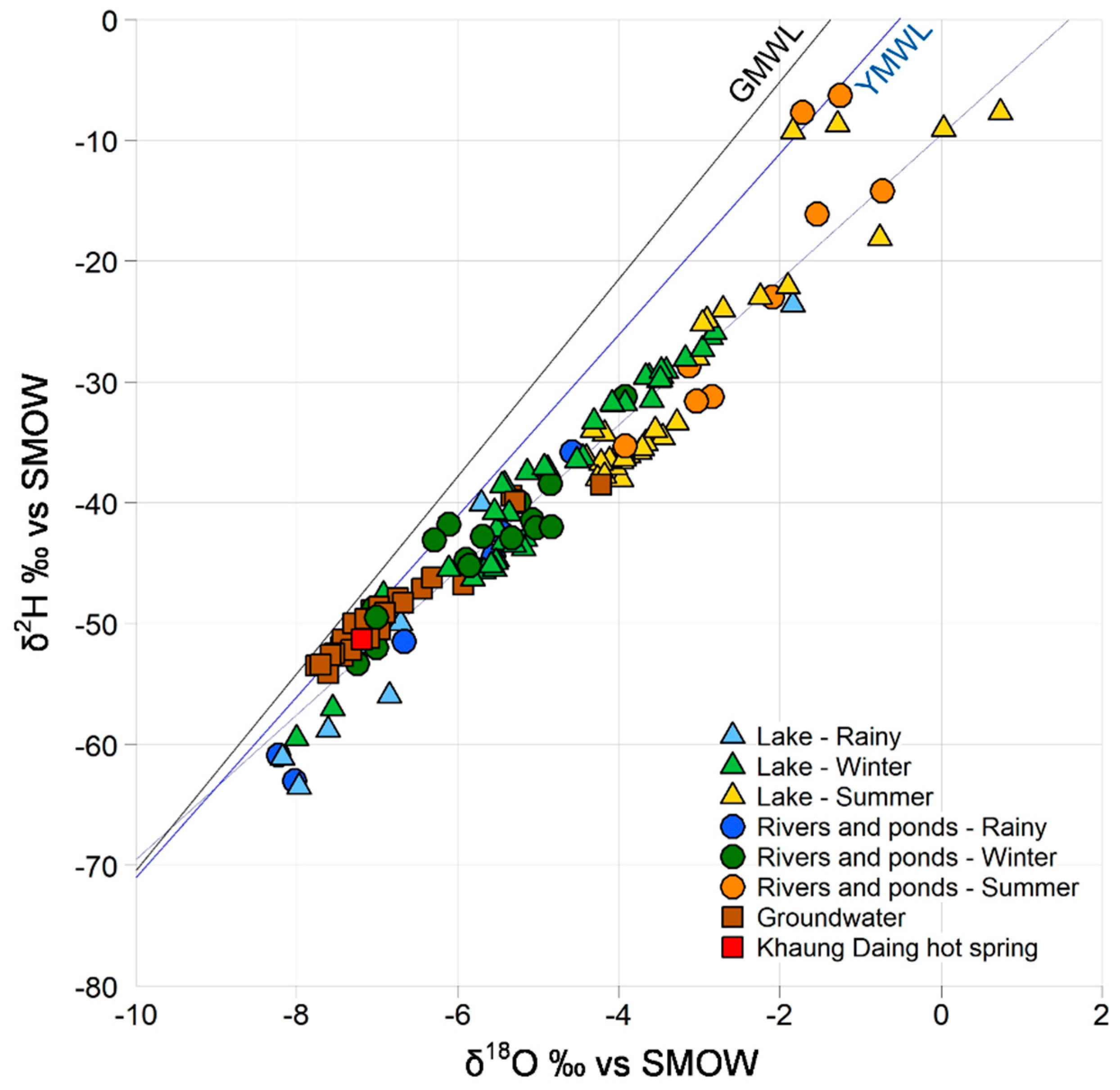
| Season | δ18O (‰) | δ2H (‰) | d-Excess (‰) | |
|---|---|---|---|---|
| Rainy | R1 (inflow) | −7.28 ± 1.49 | −56.1 ± 10.2 | 2.12 ± 2.52 |
| lake | −6.40 ± 1.94 | −50.0 ± 12.5 | 1.24 ± 4.62 | |
| R4 (outflow) | −5.57 ± 1.05 | −43.3 ± 7.9 | 1.26 ± 0.53 | |
| Winter | R1 (inflow) | −6.18 ± 0.73 | −46.5 ± 4.7 | 2.90 ± 1.30 |
| lake | −5.90 ± 1.06 | −44.7 ± 7.2 | 2.51 ± 2.76 | |
| R4 (outflow) | −5.3 ± 1.27 | −41.9 ± 8.5 | 0.86 ± 2.23 | |
| Summer | R1 (inflow) | −2.58 ± 0.95 | −21.5 ± 12.5 | −0.81 ± 4.94 |
| lake | −2.38 ± 1.49 | −23.9 ± 10.4 | −4.83 ± 4.93 | |
| R4 (outflow) | −2.40 ± 1.44 | −24.8 ± 10.7 | −5.62 ± 0.91 |
Publisher’s Note: MDPI stays neutral with regard to jurisdictional claims in published maps and institutional affiliations. |
© 2021 by the authors. Licensee MDPI, Basel, Switzerland. This article is an open access article distributed under the terms and conditions of the Creative Commons Attribution (CC BY) license (https://creativecommons.org/licenses/by/4.0/).
Share and Cite
Re, V.; Thin, M.M.; Tringali, C.; Mya, M.; Destefanis, E.; Sacchi, E. Laying the Groundwork for Raising Awareness on Water Related Issues with a Socio-Hydrogeological Approach: The Inle Lake Case Study (Southern Shan State, Myanmar). Water 2021, 13, 2434. https://doi.org/10.3390/w13172434
Re V, Thin MM, Tringali C, Mya M, Destefanis E, Sacchi E. Laying the Groundwork for Raising Awareness on Water Related Issues with a Socio-Hydrogeological Approach: The Inle Lake Case Study (Southern Shan State, Myanmar). Water. 2021; 13(17):2434. https://doi.org/10.3390/w13172434
Chicago/Turabian StyleRe, Viviana, Myat Mon Thin, Chiara Tringali, Mya Mya, Enrico Destefanis, and Elisa Sacchi. 2021. "Laying the Groundwork for Raising Awareness on Water Related Issues with a Socio-Hydrogeological Approach: The Inle Lake Case Study (Southern Shan State, Myanmar)" Water 13, no. 17: 2434. https://doi.org/10.3390/w13172434
APA StyleRe, V., Thin, M. M., Tringali, C., Mya, M., Destefanis, E., & Sacchi, E. (2021). Laying the Groundwork for Raising Awareness on Water Related Issues with a Socio-Hydrogeological Approach: The Inle Lake Case Study (Southern Shan State, Myanmar). Water, 13(17), 2434. https://doi.org/10.3390/w13172434