Abstract
Understanding hydrogeological processes at the origin of thermal and mineral groundwater are necessary to ensure their sustainable management. However, many processes are involved in their genesis and often only one or two processes are investigated at the same time. Here, we propose to use an innovative combination of geochemical, isotopic (34S, 14C, 18O, 2H) and geothermometry tools to identify, for the first time in a multi-composite geological context, all processes at the origin of diversified thermo-mineral waters. 19 springs covering a wide range of temperature and chemical composition emerging on a restricted area of Corsica Island (France) were selected. Geochemical results highlight five geochemical provinces, suggesting a common origin for some of them. Geothermometry tools show the unexpected involvement of a common deep groundwater reservoir within this non-active zone. Water stable isotopes highlight a contrasted altitude in recharge areas supplying lowland springs. This suggests that different flow patterns have to be involved to explain the wide geochemical diversity observed and to allow the design of a very first conceptual groundwater-flow model. This paper demonstrates the efficiency of the combination of the selected tools as tracers of water–rock interaction, independently of flow depth, intrinsic water properties, geological conditions and interaction time disparities.
Keywords:
hydrochemistry; isotope hydrology; geothermometry; mineral water; thermal water; gaseous springs; CO2; brines; Corsica 1. Introduction
Mineral and thermal groundwaters are very special water resources characterised by stable and specific geochemical characteristics in terms of dissolved ions and gaseous contents as well as stable, and most of the time, relatively high temperatures. Groundwater circulation in-depth increases the complexity and the multiplicity of groundwater pathways and provides a high diversity of water qualities with potential health benefits such as for thermal, alkaline, CO2-rich, brines, ferruginous or sulphurous waters [1,2]. These processes can be even more complex in the case of long-residence-time groundwater [3,4,5,6]. Geochemical and isotopic tools are very interesting when used together and can provide information on water origins as well as an estimation of the timing of the processes. Nevertheless, most of the time, these processes were studied in regions with only one or two regional geological units [7,8,9,10,11,12,13,14]. Indeed, many regions with a complex and a multi-composite geological structure, such as Corsica, have a wide mineral and thermal water diversity. Their origin and the hydrogeological processes responsible for the thermo-mineral specificity and diversity are too complex to be clearly understood [1,5,14,15].
In such regions, for better water management purposes and to guaranty the economical sustainability of the exploited resources, it can be necessary to understand precisely the water–rock interaction processes to discriminate the flow paths involved in the thermo-mineral groundwater genesis. Corsica Island (Western Mediterranean, France) is known for its complex geological settings and has an important spa tradition heritage with 43 minerals and thermal springs inventoried, spread over the entire island [16,17,18,19,20,21].
Motivated by the gap of knowledge about hydrogeological processes and flow patterns at the origin of Corsican mineral waters, new investigations have been carried out on the eastern part of the island, which is well known for displaying the highest mineral groundwater diversity over the island. The main objective was to provide a first conceptual hydrogeological model of the whole hydrosystem. The action was structured along different tasks: (1) describing the diversity of the different springs, (2) characterising water–rock interactions, including the identification of biotic or abiotic processes, as well as mixing processes, (3) assessing the depth of reservoirs and finally, (4) identifying the origin of groundwater and locate the recharge areas. This work provides significant new information on a still under documented region.
2. Study Area Description
2.1. Localisation, Topography and Hydroclimatology
The study area is located on the eastern part of Corsica (France) and is extending over 1500 km2. The inland part (2/3 of the area) is mountainous with max 2136 m asl elevation, and the coastal part (1/3 of the area) is a lowland coastal-plain area touching the Tyrrhenian Sea. Three main rivers oriented to west-east drain the zone, the Solenzara River in the south, the Tavignanu River in the middle and the Golu River in the north (Figure 1). In the mountainous part, the climate is considered as sub-alpine, with a mean annual precipitation of 1350 mm and a mean annual temperature of 12 °C [22,23]. In the coastal plain area, the climate is typically Mediterranean with a mean annual precipitation of 650 mm and a mean annual temperature of 16 °C. The potential evapotranspiration is estimated about 2590 mm in the coastal regions of Corsica and the aquifer recharge rate is around 127 mm/y (about 16% of yearly rainfall) [24,25].
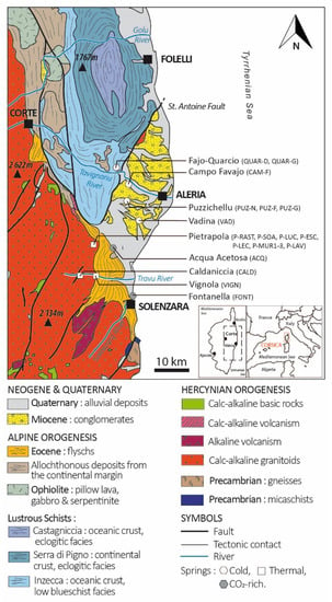
Figure 1.
Location of the study area with geology, topography, hydrography and distribution of mineral and thermal waters from the eastern part of Corsica Island (France). Symbols: white square depicts thermal springs, grey hexagon depicts CO2-rich springs and white hexagon depicts cold springs.
2.2. Geological and Hydrogeological Settings
The study area is composed of four geological units (Figure 1) [17]. The Hercynian basement, composed by calc-alkaline granitoid, is extending from the north-west to the southern part. It is overlapped along a N.NW–S.SE axis by two other units resulting from the Alpine orogenesis: the Eocene flysch, a sedimentary detrital unit located on its southern part from Corte to Solenzara cities and the Alpine metamorphic unit, mainly calc-schist, overlapping the Hercynian basement in its northern part. The latter units are separated toward east from Neogene sedimentary deposits by the Saint Antoine fault trending N.NE–S.SW (N020°) [19] (Figure 1). The geology, the mineralogical composition and the hydrogeological functioning of each unit encountered in the study area are described in the following paragraphs.
- The Hercynian basement is mainly composed by biotite-rich monzogranite, tonalogranodiorite or monzogranodiorite [17,26]. Monzogranite, mainly located around Pietrapola (Figure 1), is composed by alkaline quartz [SiO2] (≈20%), alkaline feldspar [Na, K] (≈50%) and plagioclase [Na, Ca] (≈30%). Tonalogranodiorite and monzogranodiorite, mainly located in the Travu Valley (Figure 1), are, respectively, composed of quartz [SiO2] (24.4–32.6%), plagioclase [Na, Ca] (52.6–38.2%), alkaline feldspar [Na, K] (7.2–19.7%), biotite [K, Mg, Fe, F] (11.6–7.5%), amphibole [Ca, Mg, Fe] (3.6–1.2%). This basement is intensively fractured and shows many faults NE–SW oriented [17]. Only few hydrogeological studies describe very basic information on the different groundwater types and hydrogeological characteristics of this unit. Deep fractures and discontinuities associated to the superficial weathered levels are favourable to the groundwater storage and flow [16,26,27,28,29,30].
- The Alpine metamorphic units are composed of allochthonous material derived from the exhumation of oceanic and continental tectonic units involved in the Alpine orogeny (from the Late Cretaceous to the late Eocene, e.g., [21]). These tectonic units include meta-granitoid, metasedimentary rocks as serpentinites, meta-gabbros and meta-basalt. Lustrous schists observed were affected by a wide range of metamorphism-induced deformations going from blueschist facies (mainly Inzecca series), eclogite facies (mainly Serra di Pigno and Castagniccia series) to greenschist facies [18,21,31,32,33]. This geological formation, intensively pleated, is characterised by a lot of discontinuities displaying NS orientation of schistosity in the eastern part of the study site. The hydrogeological favourable zone is located in shallow-eroded parts or through deeper structural discontinuities.
- The Eocene detrital sedimentary flysch is an autochthonous unit structured as a vertical alternation of conglomerates, sandstones and clay, mainly composed by arkose (formed by quartz [SiO2] (up to 60%), feldspar [Na, K, Ca] (less than 20%), micas (up to 20%)) and pelites rocks. In its western part, this formation rubs along with the Hercynian basement according to the NE–SW contact and is overlapped by sedimentary deposits on the eastern part [16,34]. This heterogeneous geological unit has a low aquifer potential [18].
- The Neogene sedimentary units are very heterogeneous and constituted by lateral deposits of organic matter-rich marls, sandstone and rhyolite conglomerates. Called the “Aghione formation” (Burdigalian and Langhien) these sand-conglomerate sediments are covered by black marls (Miocene) [18]. Locally, these sediments are also composed of limestone and bioclastic sandstone (Tortonian). Due to basin subsidence, Neogene lithology deposits dip to the east and have an approximate thickness of 2 km at the coastline and can reach 8.5 km in the middle of the Corsica Channel. Covered by Quaternary alluvial deposits (Figure 1). Neogene sediments host few shallow local aquifers with very low productivity. However, the thickness of the detrital Miocene layer is in favour of a real hydrogeological potential as a deep multi-layer confined aquifer [19,20].
2.3. Thermal and Mineral Waters in Corsica: Historical Background
At the beginning of the 19th century, the Corsica Island had the highest number of thermal spa in France [35] thanks to its huge hydromineral diversity with thermal, sulphurous, carbogaseous and ferruginous springs. Corsican springs provided access to a wide therapeutic treatment panel and was indicated to treat many diseases, from anaemia to colonial diseases such as malaria [36]. At the beginning of the 20th century, the numerous medicinal and therapeutic recognized advantages from these diversified springs have attracted international spa patients and medical scientists until 1926, when more than 52 doctors were employed in Corsican spas [37,38].
However, the insecurity due to the persistence of the banditry (the Guagno hostage crisis), the insalubrity or the lack of refurbished spa infrastructures, associated to the malaria disease raging in the lowland part of the island, gave start to the decline of the international interest in Corsican thermalism [39]. During the inter-World War period the local and wealthy population sustained the local thermalism. However, at the end of the Second World War, although the activity resumed on few sites (thanks to the universalisation of the French social insurance system) the wars-economic trauma associated to the dismantlement of the French colonial empire (and the end of the “colonial-tourism”) lead to the final ending of the Corsican thermalism industry, despite the parallel development of this sector on mainland France at the same time [37,38,39,40].
Since, on 43 thermo-mineral springs [34], the Pietrapola site is the only one still exploited, as a thermal spa, in the eastern part of the island. The other famous thermal spa of the Puzzichellu site is now abandoned but the ancestral spring called PUZ-G, PUZ-N and an artesian borehole (PUZ-F) are still emerging. These springs are included in this study (Table 1). However, for a future sustainable exploitation of the Corsican thermo-mineral springs, a scientific characterisation is requested to bring arbitration elements on springs exploitation potential. To this end, this paper aims at characterising their origin and their hydrogeological functioning to document the sustainability and the vulnerability of the resources.

Table 1.
Background information on sampling sites: spring codification, location and observations. Spring type is described as “Natural” for spring without equipment to channel water flows; “Modified” for springs with equipment to channel water flows; “Borehole”. (X) Presence, (-) Absence.
3. Methods
3.1. Sampling Network
On the study area, 19 mineral springs emerging at low altitude (<284 m asl), and were monthly sampled from January to June 2014: (Table 1, Figure 1):
- 8 springs of the Pietrapola group: P-SOA, P-MUR1, P-MUR3, P-LAV, P-LUC, P-RAST, P-ESC, P-LEC;
- 3 springs of the Puzzichellu group: PUZ-N, PUZ-F, PUZ-G, including the near-by Campo-Favajo site (CAM-F) and the “Fajo-Quarcio” site labelled: QUAR-G, QUAR-D;
- The Travu River Valley with a Vignola single spring (VIGN) and Caldaniccia single spring (CALD);
- 2 single isolated CO2-rich springs of Acqua Acetosa (ACQ) and Fontanella (FONT);
- The single cold spring of Vadina labelled as VAD.
In order to identify the regional rainfall input, we collected water stable isotopes at 5 stations of the Corsica rainwater monitoring network [41]: Aleria (9 m), Bastia (1 m), Bonifacio (99 m), Corte (486 m), Campana (760 m) and Palneca (785 m).
3.2. Groundwater Sampling and Analytical Methods
Electrical Conductivity (EC) and Temperature (T) were measured with a WTW cond 3410 and the redox potential (Eh) and pH were measured with a WTW multi 3410 (WTW gmbH, Weilheim, Germany). Bicarbonate concentration (HCO3) was determined, in the field, using a HACH digital titrator (HACH Company, Loveland, CO, USA).
Major ions samples were filtrated through 0.45 µm nitrocellulose membranes in two 50 mL polyethylene bottles before storage at 4 °C. One bottle was acidified using ultrapure nitric acid for cation analysis, A Dionex ICS 1100 chromatograph (Thermo FischerScientific, Waltham, MA, USA) was used to determine ionic concentrations at the Hydrogeology Department (CNRS UMR 6134 SPE) of the University of Corsica. The analysis was checked and validated with an ionic balance under 5%.
Silica concentration (SiO2) was sampled from a 150 mL PEB bottle, quantified with the Molybdosilicate method and analysed with a spectrophotometer Genesys 10S UV–VIS (Thermo Fisher Scientific, Waltham, MA, USA) at the Hydrogeology Department (CNRS UMR 6134 SPE) of the University of Corsica, France.
Trace elements were collected in 50 mL HDPE bottles after filtration through a 0.20 µm pore size nitrocellulose membrane filter, then acidified with ultrapure nitric and stored at 4 °C. They were analysed by the Q-ICPMS X series II (Thermo Fisher Scientific, Waltham, MA, USA) at the AETE technical platform of the University of Montpellier, France.
Stable isotopes of the water molecule (δ18O/δ2H) were collected in a 20 mL amber- glass bottle filled without no filtration and no headspace to ensure perfect conservation and stored at 4 °C. They were determined using a Liquid-Water stable isotope analyser DLT-100 (Los Gatos Research, San Jose, CA, USA) at the Hydrogeology Department (CNRS UMR 6134) of the University of Corsica, France, following the analytical scheme recommended by the IAEA [42]. The analytical precision was better than 0.5‰ for δ2H and 0.2‰ for δ18O.
Samples for 34S-H2S analyses were conditioned in a 125 mL amber-glass bottle after filtration through a 0.45 µm pore size nitrocellulose membrane and stabilised with the addition of 12 mg of cadmium acetate. To analyse 34S-SO4, one-litre PEHD bottles were filled with filtered water through a 0.7 µm pore size glass fibre membrane filter and acidified with HCl. At the laboratory, samples were saturated with 5 mL of BaCl2 solution to precipitate and settled BaSO4, then rinsed with 500 mL of distilled water. The precipitate is recovered on the 0.45 µm nitrocellulose membrane and desiccated before the sending for the analyse by mass spectrometry (IRMS) at the Isotope Science Laboratory, University of Calgary, Canada. The 18O-SO4 analyses were performed from the same sample by isotope ratio mass spectrometer Delta+ (Thermo Fisher Scientific, Waltham, MA, USA) at the same laboratory.
For radiocarbon (14C) and 13C analyses from dissolved inorganic carbon, 1 L of groundwater was sampled in a PEHD bottle without headspace and stored at 4 °C. The analysis was performed by Accelerator Mass Spectrometry (AMS) for both isotopes following the analytical scheme recommended by the IAEA [43,44,45,46] at the Beta Analytic testing laboratory, London, United Kingdom.
4. Results and Discussion
4.1. Thermal and Mineral Description
4.1.1. Physico-Chemical Parameters
According to literature, the discharge temperature of mineral waters can discriminate waters with a thermal anomaly, called “thermal waters”(T > 20 °C) from “cold waters” (T < 20 °C) [47]. Among thermal waters, the highest temperature is observed at the Pietrapola springs group (P–X), where their temperatures range from 31 to 54 °C which classifies them from mesothermal to acrothermal waters. The Travu River Valley shows two thermal springs, both classified as hypothermal: Caldaniccia (CALD) with a temperature of 33.5 °C and Vignola (VIGN) with a temperature of 27.6 °C (Figure 2A, Table 2). These temperature anomalies (T > 20 °C) suggest deep circulations. The pH of thermal waters is basic and ranges, according to the springs, from 8.9 to 9.9 for Pietrapola, 8.3 for Vignola and 9.2 for Caldaniccia. Electrical conductivity is stable and rather low with ≈350 µS/cm for Pietrapola and ≈150 µS/cm at Caldaniccia and shows a high and unexpected value for Vignola (≈3000 µS/cm) (Table 2). Temperature and pH measured in 2014 are consistent with respective measures from 1980 [34]. High temperature and high pH are typical of a deep magmatic rocks circulation [13,48,49]. This 6 months’ survey highlights strong mineralisation stability and is characteristic of the involvement of deep groundwater processes controlling the water quality. The temperature stability, observed for decades, expresses an up-flow without surface influence or mixing processes with shallow unconfined groundwater [34]. For two springs (P-LEC and P-LAV), where a 3 °C cooling associated to EC variations is observed compared to 1980, it then probably translates mixing with shallow water.
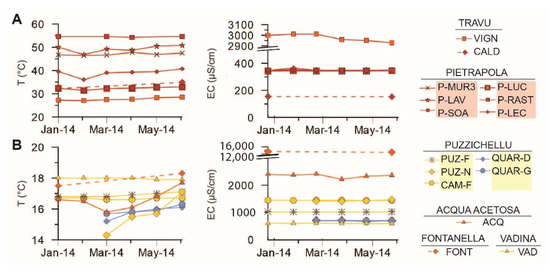
Figure 2.
Time evolution of physico-chemical parameters (T and E.C.) of groundwater, discriminated as thermal (A) and cold (B) waters (N = 92).

Table 2.
Physico-chemical parameters and concentration in major chemical constituents (mg/L) as well as water stable isotopes values for mineral and thermal waters. (-) Non-measured.
The temperature of cold waters (T < 20 °C) ranges from 14.2 °C (PUZ-G) to 18.3 °C (FONT) (Figure 2B, Table 2). These lower and stable temperatures show that groundwater flows at a shallower depth than thermal waters. Cold waters show a pH ranging from 6.0 to 8.6 with intermediate (600 µS/cm) to high EC values (13,500 µS/cm). FONT and ACQ springs, flowing out from the flysch, have an acid pH, respectively, of ≈6.3 and ≈6.1 and a clearly visible CO2-rich content. These bubbling springs show a higher conductivity (ACQ ≈ 2300 µS/cm and FONT ≈ 13,500 µS/cm) compared to springs flowing through the flysch [50] (Figure 1, Table 1). Four springs (QUAR-D, QUAR-G, PUZ-N and ACQ) show a seasonal temperature variation without EC variation. This is probably due to their very low discharge rate, which can favour the influence of the atmospheric temperature on the mineral water temperature (Table 1). Generally, the temperature and the electrical conductivity of the investigated springs is rather consistent with the 1980s data [34]. This underlines the stable characteristics of the different mineral water at the seasonal and decennial time scales.
4.1.2. Diversity of Hydrochemical Water Types
The Piper diagram (Figure 3) displays different water types found over the study area. Thermal waters P-X and CALD, with basic pH and low EC, display a typical HCO3-Na water type in agreement with the processes of mineralisation coming from groundwater flow through granitoids rocks [14]. The thermal spring VIGN shows a Na-Cl water type, such as the cold spring FONT, indicating a long water–rock interaction time with detrital deposits or a contribution of moderately saline water such as brines. The CO2-rich spring ACQ shows an intermediate water type, a Ca-Na-HCO3 water type, which has already been observed as a result of the mixing processes of water flowing through magmatic and sedimentary rocks [14] but it can also be due to a high proportion of aluminosilicates weathering.
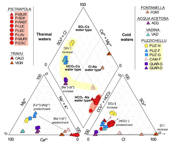
Figure 3.
Piper diagram of Eastern Corsica thermo-mineral groundwater (N = 84). The spring group of Pietrapola is displayed in red background while Puzzichellu is displayed in yellow background.
VAD and two springs of the Puzzichellu group PUZ-F and PUZ-G (H2S-rich water) have a Ca-HCO3 water type. In the same area, a few meters apart, the other spring PUZ-N shows a Ca-HCO3-SO4 water type due to a higher concentration in sulphate compared to PUZ-F (borehole tapping groundwater at 41 metres in-depth) and PUZ-G (spring) (Table 1). The geochemical disparity observed at the same site shows that the geochemical signature is influenced by another process than the water–rock interaction time. On a larger scale, the Puzzichellu springs group also shows a Ca-Na-HCO3 water type (QUAR-D, QUAR-G) and a Na-HCO3 water type (CAM-F) (Table 1). So, the very local geology only partially explains the geochemical diversity observed.
4.1.3. Mixing Processes during Up-Flowing
To understand the maturity of water and also to discriminate geothermal systems among volcanic (SO4-end-member), peripheral (HCO3-end-member) or mature waters (Cl-end-member), relative content in major ions Cl, SO4 and HCO3 were classified on a ternary diagram (Figure 4B) [51].
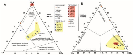
Figure 4.
Ternary diagram displaying groundwater chemical content (SO4, Cl, Ca, Mg, Si and HCO3). The spring group of Pietrapola is displayed in red background while Puzzichellu is displayed in yellow background. The ternary (A) displays the main lithology involved in water mineralisation. Indeed, this [Ca-5*Mg-10*Si] diagram is usually used to illustrate the lithology of rocks involved in water–rock interactions [52,53]. Due to the absence of Si value, FONT and CALD are not displayed on this plot. Developed by Giggenbach [54], the (B) ternary diagram helps discerning mature and peripheral waters and gives crucial information about fluid mixing.
The FONT and VIGN spring plots close to the Cl-corner which make them as “mature waters”. Indeed, both springs provide highly mineralised waters, sodium-chlorite-rich and testifies for brine waters occurrences at depth [55,56]. All other waters plot close to the HCO3-corner and can be considered as “peripheral waters”. Cold waters are related to direct infiltration from meteoric water through soil. For thermal waters, the HCO3-content observed (P-X and CALD) usually indicates an important distance from the heat source [11,51,57]. So, the natural geothermal gradient is the only process involved in the warming of waters.
4.2. Water–Rock Interactions
The Figure 4A displays a ternary plot of Si, Ca and Mg-proportions according to local lithology and highlights the different water–rock interactions involved in the groundwater mineralisation [52,53].
4.2.1. Granitoid-Rocks Minerals Hydrolysis
The proportion of silica, close to 100% for Pietrapola springs is linked to the very low concentration in Ca and the absence of Mg in the water. For the VIGN spring, Ca amount is relatively more important than in the Pietrapola springs because the geological context is different. Indeed, the VIGN spring emerges at the interface between granitoids and carbonate-rich flysch, which gives to the groundwater a slightly more carbonated fingerprint.
Differentiating granite-minerals involved in the mineralisation processes of thermal water is allowed by considering Figure 5A, which shows the Na/K ratio as a function of SiO2. Indeed, the alkali–feldspar alteration process is highlighted for the P-X springs which show the highest SiO2 concentrations (from 20 to 90 mg/L) and the lowest Na/K ratio (≈15) [54,58]. This low ratio is characteristic of the cations exchange between albite and alkaline feldspar at high temperature and under deep reservoirs conditions, as it can be found in Hercynian granitoid rocks [57,59]. According to local geology, the Pietrapola springs emerges from monzogranite with high feldspar content, which is able to explain the Na and K concentration observed in the groundwater. CALD and VIGN show a higher Na/K Ratio (≈50) for an intermediate SiO2-content (between ≈20 mg/L and ≈38 mg, respectively) which reveal different interaction kinetics inside the granitic reservoir and another kind of hydrolysis process at the contact with another granitoid type, more enriched in plagioclase in the Travu River Valley. Indeed, this ratio is characteristic of granodiorite and is responsible for the high Na content observed there. Granodiorite or monzogranite show a similar and relatively high SiO2 content which tend to indicate relatively long water–rock interaction time within the reservoir.
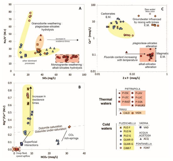
Figure 5.
Ions scatter diagram displaying some major ion content or ratio (Na/K, SiO2, F, Mg/Ca, Ca and HCO3) associated with trace elements (Li, As, B, Rb/Sr ratio), W.r.: weight ratio. The spring group of Pietrapola is displayed in red background while Puzzichellu is displayed in yellow background and the Travu River Valley in orange background. The (A) plot discriminates the Na+ and K+ content according to granitoid type; the (B) plot illustrates the shallow influence at the origin of HCO3−, Mg2+ and Ca2+ content; the (C) plot corresponds to fluorite weathering in hydrothermal waters.
All thermal groundwaters are Mg-depleted with a low HCO3 content (Figure 5B). This shows the influence of a deep and high temperature reservoir on the hydrolysis reactions, followed by a fast up-flowing process [60,61]. The Figure 5C displays the Ca as a function of F-content and highlights water–rock interaction processes between the basement-rocks and the following direct upwelling of geothermal fluids [62,63]. Indeed, F-content in groundwater is linked to Hercynian granitoid interactions [64] due to its enhanced mobilisation at a high temperature. Hydrothermal waters are marked by high F-content and low Ca-content and plot close to the granitoid end-member [65]. Due to the temperature-dependency of fluorite CALD, the coldest springs (≈32 °C), is less enriched in F than other thermal waters.
4.2.2. Detrital Sedimentary Rocks Weathering
The VAD spring (Figure 4A), shows the highest Ca-concentration, which is linked to its flows through local limestone and calcareous sandstone. A carbonated signature of groundwater is also observed for the ACQ spring with its Ca-HCO3 water-type emerging at the interface of the Eocene flysch and Miocene sedimentary rocks. Within the Puzzichellu springs group, QUAR-D and QUAR-G plot close to the carbonate rocks end-member due to their local metamorphosed calc-schist geology (Figure 1, Table 1) which explains their water type (Ca-HCO3). Considering its sedimentary context, CAM-F displays an unexpected Si-content (Figure 4A). This high SiO2 amount [≈22 mg/L] associated to a high Na/K ratio (≈75) suggest a mixing process occurring with deep flow from granitoid, which is able to explain the Na-intake.
The Figure 5B displays the Mg/Ca ratio as a function of HCO3 concentration in order to discriminate dilution processes during the up-flow from water–rock contact time influence. QUAR-D, QUAR-G, VAD and FONT show proportional increase in Mg, Ca and HCO3 without significant seasonal variation. This trend suggests mixing with phreatic water in sedimentary rocks providing a proportional income of Mg, Ca and HCO3 with a low ratio (<0.2) and low HCO3 (<10 meq/L). FONT and ACQ, both bubbling springs, show the highest HCO3 content (up to 35 meq/L). Their high mineralisation is due to the intensive water–rock interactions boosted by the aggressiveness of low pH induced by the high CO2 solubility at low temperatures [48]. However, ACQ shows a seasonal variability of the dissolved content, explained by the surface waters contribution.
Despite the Puzzichellu site hydrofacies disparity (Figure 4A), all springs seem to flow through the same aquifer composed of detrital conglomerates from the heterogeneous Miocene sedimentary deposits [18]. The Puzzichellu spring group shows a seasonal variability of the Mg/Ca ratio without any effect on the HCO3−content. The absence of seasonal HCO3 variation discredits any HCO3−mobilization due to phreatic flow through sedimentary rocks but translates disparities in water–rock interaction times, explained by the relative stability of ferromagnesian minerals (Mg-rich) and plagioclase feldspar (Ca-rich).
4.2.3. Evidence of Brine Waters Occurrence
FONT (CO2-rich) and VIGN, both mature waters, display the same signature in fluoride with an intake of Ca-content, probably given by the carbonate signature of the flysch (Figure 5C). Those values plot close to the seawater end-member, their Na-Cl hydrofacies combined with the high E.C. and high amount of chlorite and fluoride indicates residual brines, probably due to a dissolution of interstitial seawater residue, or connate waters occurrence. This saline water is emerging mixed with infiltrating meteoric waters, and after having leached the upper part of the brines out from the sediments, this process is well referenced around the Mediterranean basin [66,67,68].
4.2.4. Mixing Processes
Principal component analysis (CPA) was performed from major and trace elements (Figure 6, Table 3). The first two axis explain 72.78% of the total variance of the population, F2 is positively correlated to F, K and Rb (magmatic elements) and negatively to Mg, HCO3 and Ca (sedimentary elements) and discriminates them. While F1 is negatively correlated to As and SiO2 (hydrothermal elements) and positively correlated with Sr and E.C. This axis discriminates magmatic influences, with its high As-content related to the presence of geothermal fluids [63], from mixing flows involving different flow pattern with high Sr-content due to the increase in combined sedimentary and granitoid rocks hydrolysis [69].
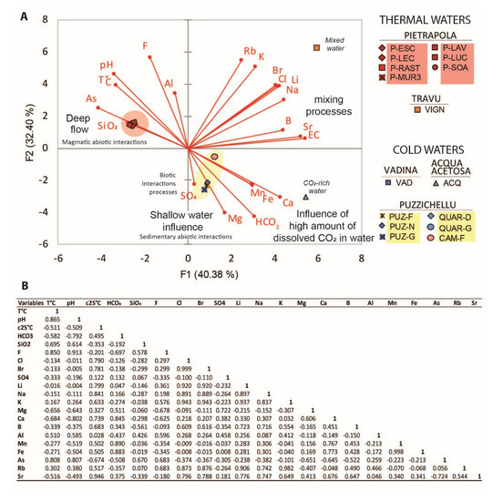
Figure 6.
Principal Component Analysis (PCA) discriminating the origin of trace elements and the geological influence on spring water composition. The spring group of Pietrapola is displayed in red background while Puzzichellu is displayed in yellow background. (A) This figure displays both correlation factors (F1 and F2) according to variables (parameters) and observations (springs contents); (B) table displaying the correlation matrix associated to (A), according to Pearson (n − 1).

Table 3.
Concentrations in trace elements.
The Figure 6 highlights the main reservoirs involved in the mineralisation of cold waters (except ACQ and CAM-F), which are flowing mainly through sedimentary rocks and are influenced by shallow waters mixing, while thermal waters (except VIGN) flow mainly through magmatic rocks without shallow water mixing and dilution. Both exceptions (VIGN and ACQ) seem to be influenced by more complex mixing processes, combining deep brines up-flowing and then mixing with phreatic flow through sedimentary and/or magmatic rocks. This is clearly observable on VIGN, which is influenced by brines and waters flowing through magmatic rocks at the same time. This flow pattern is able to dilute magmatic As concentration [up to 0.03 µg/L] and cause an intake in Li [1440 µg/L] and B [1824 µg/L] (Table 3). The dissolved CO2 increases rock-hydrolysis, and then the amount of dissolved elements in water which can explain Ca, Mn and Fe concentrations observed in ACQ [70,71]. CAM-F, which springs out from the sedimentary plain, is mainly influenced by deep regional flow influenced by magmatic abiotic interactions.
4.2.5. Elements Prevalence at Depth
A pH–Eh diagram (Figure 7) was used to characterise the reservoirs conditions affecting the trace elements prevalence in groundwater. All springs are under reducing conditions and highlight that most flow paths are mainly under anoxic geological confinement, except for the two cold springs of VAD and ACQ. VAD, which plots under oxidative conditions during all the monitoring, is influenced by surface waters mixing with phreatic flow through locally karstified limestone able to oxidise and equilibrate water during the flow path. ACQ shows oxidative conditions only during the wet period, which is probably due to the major contribution and mixing with surface waters at this time. For thermal waters, some springs (P-LUC, P-LEC, P-ESC and P-SOA) present oxidising conditions only during the April campaign. According to other values obtained during the monitoring, this oxidation is not significant and is probably due to the probe’s wear and its sensibility to high temperature. As observed on the PCA, this diagram confirms a favourable condition allowing the occurrence of HAsO42−(aq) for Pietrapola (granitic) but also for VAD (sedimentary). The iron ionic predominance allows confirming the FONT and ACQ springs as ferruginous springs (Fe2+ iron form prevalence) (Table 1). These two springs are Cl-rich. According to the alteration state of biotite contained in granite, the Cl and Fe content increased consequently in water [72]. All springs display conditions favouring dissolved sulphate content. However, CAM-F, which flows under reducing condition, shows a temporal trend to sulphate reduction in H2S(g) during the dry period (Figure 7). Despite the diversity of the geological conditions, this homogeneous content in sulphate is asking about a possible common origin.
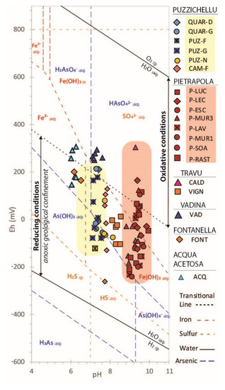
Figure 7.
Pourbaix diagram of sulphur, arsenic and iron elements. The spring group of Pietrapola is displayed in red background while Puzzichellu is displayed in yellow background.
4.3. Reservoir Conditions and Depth Assessment
4.3.1. Water Equilibration in the Reservoir
The Na-K-Mg ternary diagram (Figure 8), proposed by Giggenbach [54], can be used to estimate geothermal reservoir temperatures, to distinguish equilibrium status and to classify geothermal waters as immature, partially equilibrated and fully equilibrated waters.
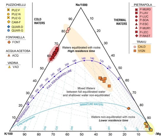
Figure 8.
Distribution of thermo-mineral springs water on a Na-K-√Mg Giggenbach diagram [54], which allows determining reservoir temperature and equilibration status of rock with water. The spring group of Pietrapola is displayed in red background while Puzzichellu is displayed in yellow background and the Travu River Valley in orange background.
All cold waters plot within the immature zone, Mg-corner, which means these waters aren’t equilibrated with rocks and show a relatively low residence time as confirmed by the 14C age estimated at PUZ-F (4720 year, apparent radiocarbon age, Table 4). Indeed, the presence of Mg content in the water induces shallow flow influence or indicates re-equilibration by mixing with phreatic-water during the up-flow as observed for partially equilibrated waters of VIGN and FONT, which plots within the mixed zone [11,54,73,74]. Indeed, Mg dissolution appears under low temperatures, this process explains why all thermal waters, except VIGN, plot above the full-equilibrated line and highlight waters emerging fully equilibrated without geochemical modifications due to dilution, mixing or any other cooling phenomenon. This tends to indicate a full equilibration of water with rocks due to a very high residence time confirmed by 14C apparent age estimations on P-MUR3 (8260 year, apparent radiocarbon age) (Table 4).

Table 4.
Radiocarbon data and related physico-chemical parameters on non-gaseous thermal (P-MUR3) and cold (PUZ-F) springs. The “apparent age” refers to Stentröm, 2011 calculations [75]. The mention “not corrected” refer to radiocarbon age that is not adjusted for any hydro-geochemical effects on meteoric water 14CO2 or neither adapted for hydrologic flow model.
The absence of Mg-content does not allow the use of K-Mg geothermometer on thermal water, so other types of geothermometry calculations should be used. The estimated Na-K temperature varies from 120 to 140 °C for CALD and from 180 to 220 °C for Pietrapola. The temperature gap, observed despite being part of the same geological reservoir, highlights that water at the origin of CALD spring flows at a shallower depth than groundwater emerging at Pietrapola. Figure 8 confirms also that VIGN is a mixed water between deep fully-equilibrated water with a highly mineralised, Cl-rich, shallower non-equilibrated water. This mixing explains the seasonal variability of mineralisation. Because of this up-flow dilution, the geothermometry calculation does not allow to conclude on the reservoir temperature.
4.3.2. Sulphur Origin and Geothermometry
To discriminate sulphate origin, Figure 9 displays the δ 34S-SO4 content as a function of δ 18O-SO4. Thermal waters show δ 34S-SO4 and δ 18O-SO4, respectively, ranging from 14.1‰ (P-MUR3) to 19.8‰ (VIGN) and 1.6‰ (VIGN) to 7.2‰ (P-SOA) (Figure 9A, Table 5). Cold waters show δ 34S-SO4 and δ 18O-SO4 values, respectively, ranging from 5.0‰ (VAD) to 14.8‰ (PUZ-F) and 3.9‰ (VAD) to 13.1‰ (PUZ-F) (Figure 9A, Table 5).
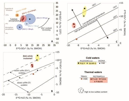
Figure 9.
Sulphur isotopes data displayed as: (A) Origin of sulphate components thanks to δ18O(SO4) versus δ34S(SO4) content in mineral waters according to bibliography values associated to their SO4-content. (B) Abiotic or biotic sulphate origin determination thanks to δ18O(SO4) versus δ18O(H2O) values observed. Dashed straight and solid lines delimit the area where dissolved sulphate (SO42−) is obtained from inorganic redox processes, from sulphur (S−) or sulphite (SO32−) [76]. (C) Geothermometers determination thanks to δ18O(SO4) versus δ18O(H2O). Dark lines show temperature reservoir determination obtained for low enthalpy reservoir only [77]. The spring group of Pietrapola is displayed in red background while Puzzichellu is displayed in yellow background.

Table 5.
S isotopes values from sulphate (SO4), sulphide (H2S) and 18O-SO4, 18O-H2S values. (*) Values used in isotope geothermometry calculation.
All springs (except VIGN and VAD) show a positive correlation between δ 34S-SO4 and δ 18O-SO4 values. This highlights a similar source in dissolved sulphur and confirms the common origin suggested previously (Figure 9) [78]. The lowest δ 34S-SO4 value is observed at VAD and plots on the atmosphere precipitation zone close to the Italian precipitation (mean = +2.1‰ and values ranging between −2.5 to +8.3‰) [79]. VIGN, with its low δ18O, is associated with a high δ34S content and plots close to seawater (δ 34 S-SW ~ +21‰) [80]. This is explained by the occurrence of brines waters coming from the flysch formations. Indeed, δ 34S-SO4 varies in relation with the geological context. The absence of negative values allows excluding pyrite oxidation as a source of dissolved sulphate [81].
Abiotic Origin of Sulphate
To discriminate oxidation among processes at the origin of abiotic dissolved sulphate, the Figure 9B displays the δ 18O-SO4 and δ 18O-H2O signatures according to sulphide (S−) or sulphite (SO3) oxidation [82]. To distinguish them, it is commonly accepted that sulphate formed by oxidation of the sulphide must show a proportional correlation between δ 18O-SO4 and δ 18O-H2O [78]. According to [73], fractionation is usually minor during the oxidation of mineral sulphide to sulphate. Figure 9B specify that six springs present an abiotic origin of sulphate: coming from Sulphide (S-) oxidation (VAD, VIGN) or sulphite (SO32−) oxidation (QUAR-G, P-LUC, P-MUR3 and P-SOA) and only one (PUZ-F) has a potential biotic origin [76,78,82].
Biotic Origin of Sulphate
Sulphide isotopic measurements (δ 34S-H2S) were performed on four springs (CAM-F, PUZ-F, P-MUR3, P-SOA) (Table 5). Results show that thermal waters (P-MUR3, P-SOA) and the cold water (VAD) have positive values while the other spring of the Puzzichellu site has a negative value (PUZ-F). This negative δ 34S-H2S associated to an increasing dissolved sulphate content at the spring reveals an intensive bacterial activity [81] (Figure 9A,B). Indeed, PUZ-F is very depleted in δ 34S-H2S (negative values) and is the most concentrated in SO4 (≈87 mg/L) (Table 5). The biotic sulphate reduction process creates δ 34S-H2S depletion and residual sulphate enrichment in δ 34S-SO4 [83,84]. In case of high organic matter content in the aquifer associated with low availability of Fe, biotic activity creates a significant amount of H2S with negative values [81]. The negative value measured at PUZ-F (δ34S-H2S = −27.7‰) specify the bacterial origin of sulphate as both chemolithotrophic sulphide oxidising bacteria (e.g., Thiobacillus hydrothermalis, Thiomicrospira spp., Achromatium volutans) and thermophilic sulphate-reducing bacteria (e.g., Desulfacinum spp., Desulfovibrio) [84]. These biological processes explain the high amount of dissolved H2S and SO4 observed in the Puzzichellu group springs (Table 1 and Table 2).
4.3.3. Reservoir Temperature and Depth Assessment
Thanks to the identification of S-bearing minerals responsible for sulphur origin in water for Mg-devoid springs (VIGN, CALD, P-X), it is possible to refine geothermal temperatures evaluated with the SO4-H2O oxygen isotope geothermometry [56,77,85] (Table 6, Figure 9C). Considering a geothermometric gradient of 30 °C/km, these calculations also allow determining the reservoir depth following the Marques et al.’s Equation [48]. Figure 9C highlights the involvement of only low-temperature geothermal reservoir (T < 150 °C). Only VIGN plot into the high-temperature geothermal reservoir but the estimated temperature should not be taken into account because of the mixing processes previously identified.

Table 6.
Sulphates isotopes geothermometers calculation compared to geochemical geothermometry and flow depth estimation.
Three isotopic geothermometry calculations were performed on thermal springs (P-X and CALD) (Table 6). Lloyd et al. as well as Mizutani and Rafter isotopic calculations show good correlation with each other [77,85]. The new isotopic calculation proposed by [67] for low-temperature geothermal application is overestimated (30%) compared to [68,76]. The [76] isotopic calculations are underestimated (80%) compared to the geochemical methods [54]. However, this comparison of isotopic geothermometry applications confirms that low-temperature geothermal method is not a good tool to estimate reservoir temperature of alkaline water flowing through granitoids [76]. However, this comparison allows to specify that a common geothermal reservoir might be at around 3 km in-depth.
4.4. Groundwater Origin and Recharge Conditions
The stable isotopic composition of groundwater displays values between −55.8‰ and −37.0‰ for δ2H, and between −8.92‰ and −6.00‰ for δ18O (Figure 10, Table 2). According to Figure 10A, all samples plot between the Global Meteoric Water Line (GMWL) [86] and the Western Mediterranean Meteoric Water Line (WMMWL) [87]. It clearly means that groundwater has a local meteoric origin and completely excludes any seawater or magmatic contribution, even for the most mineralized springs. The isotopic signature of the different springs is very coherent with values observed punctually in previous studies [88] and highlights the stability of the spring water recharge conditions.
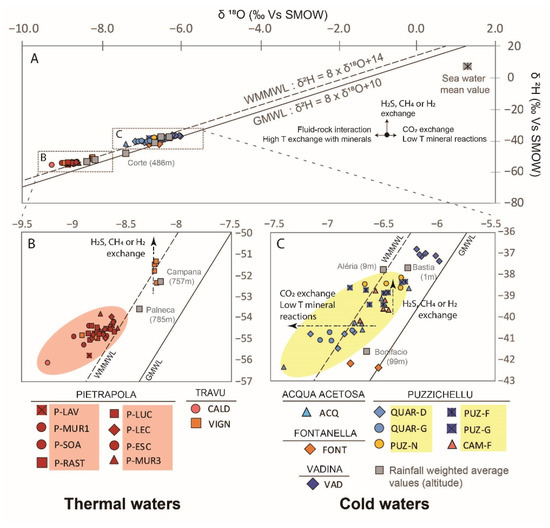
Figure 10.
δ2H Vs. δ18O plot of all minerals and thermal groundwaters. The mean stable isotopic composition of the rainfall at Bastia, Aléria, Bonifacio, Campana and Palneca are also plotted as grey squares, with their respective altitude [41]. The dotted black line is the WMMWL [87] and the black line is the GMWL [86]. (B) and (C) are zoom of (A).
An enrichment in δ2H without any effect on δ18O is observed during H2S, CH4 or H2 exchange [89]. Because variation of the δ2H value is only observed at VIGN, Figure 10B confirms that brine waters involved in the mixing have a high gaseous content. Figure 10C displays cold waters, which are more enriched in δ18O and δ2H value than thermal waters. With values ranging from −8.92 to −6.00‰ in δ18O and from −54.9 to −37.0‰ in δ2H shows that water is infiltrated at a lower altitude (<150 m asl), CO2-rich waters are characterised by a depletion in δ18O, which leads to horizontal deviation from the GMWL [89,90,91]. As expected, ACQ and FONT are also affected by this fractionation. The stable isotope value confirms that the high EC and the high Cl-content observed in FONT are exclusively due to water–rock interactions and not to seawater intrusion. The weighted mean of water stable isotope signal measured (N = 63) at each rainfall stations are as follows: Bastia (δ18O = −6.28‰, δ2H = −37.70‰), Corte (δ18O = −7.29‰, δ2H = −46.57‰), Aléria (δ18O = −6.50‰, δ2H = −37.79‰), Bonifacio (δ18O = −6.65‰, δ2H = −41.59‰), Campana (δ18O = −8.17‰, δ2H = −52.33‰) then Palneca (δ18O = −8.38‰, δ2HPalneca = −53.63‰). The mean of seven measures on the Mediterranean seawater is δ18O Seawater = +1.35‰ and δ2HSeawater = +6.31‰ (Table 2) [41,92].
Figure 10B displays all thermal waters, these waters are isotopically depleted with values ranging between −8.92 and −8.20‰ for δ18O and between −55.8 and −51.4‰ for δ2H. Compared to the rainwater values observed, thermal waters are more depleted than Campana, meaning that waters infiltrate at a higher altitude than 800 m asl [93]. Except for VIGN, which is more enriched than the other thermal waters (Pietrapola and CALD) and confirms the involvement of mixing processes. This spring-water is a mixed water between a hot, low mineralised, deep and full-equilibrated water with colder, acidic, highly mineralised waters (brines). Considering this mixing process, the recharge altitude could not be estimated. As Sardinia’s geothermal waters [94], no δ18O enrichment from high-temperature water–rock interactions is observed, which is usually expected for thermal waters (Figure 10A) [89,95]. It is due to the involvement of low-temperature geothermal processes (<150 °C).
4.5. Conceptual Model
Analyses and comparison of hydrogeochemical, geothermometric and isotopic characteristics of thermal and cold mineral waters of Eastern Corsica reveal the involvement of, at least, three groundwater-flow processes at the origin of the observed geochemical diversity. These results are illustrated on a regional conceptual model of the different flow-paths and geological units (Figure 11). Thermal waters (from 27 to 54 °C at the discharge-point), weakly mineralised (<300 µS/cm) Na-HCO3 alkaline waters, which are hosted in deep (mainly granitoid) fractured reservoirs and are influenced by low-temperature geothermal processes (<150 °C). Major faults and shear zones provide preferential pathways for rainfall infiltration from the mountainous relief (recharge > 800 m asl) and for fast up-flowing of deep water (high-temperature and Mg absence). This fully equilibrated groundwater, associated with high F-content and low 14C activity, indicates long residence times (8300 year) at depth (at least 3 km) (Table 6).
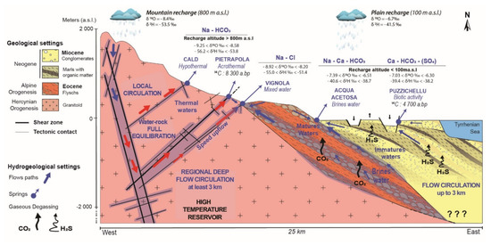
Figure 11.
Hydrogeological conceptual model of mineral waters from the eastern part of Corsica except for Vadina and Fontanella springs (out of the perspective). The primary source of water (blue arrows) is meteoric water that is heated at depth by the geothermal gradient, and which ascends as thermal fluid (red arrows) through faults (black lines).
Cold waters (14–18 °C) from shallower reservoirs, mainly made of sedimentary rocks with marly interlayers rich in organic matter, are characterised by a Ca-HCO3-(SO4) water type. These complex sedimentary deposits act as a multilayer aquifer (up to 3 km), favourable to a multiplicity of flow pattern increasing residence times disparities (4700 y). Local rainfall recharge (<150 m asl) infiltrates at a shallow depth and, thanks to the different local faults (graben and horst), can up-flow very locally. Some of these waters are not equilibrated with rocks (immature waters) and are influenced by surface waters infiltration (non-perennial, seasonal flow variation). The presence of organic matter in depth promotes the development of a bacterial activity responsible for the increase in SO4-content in water and the H2S gaseous release. This study also highlights that many springs appear at the interface between the main geological units inducing specific and complex mixing processes. Indeed, interface flow-paths favour interactions between different geological units and entail important singular geochemical and isotopic modification of water. These modifications create complex water types, depending on the mixing proportion. This study also highlights for the first time the existence of brine-type waters in the southern part of the study area, these mature waters, cold CO2-rich (acidic water), are highly mineralised (2000–12,000 µS/cm) and are characterised by a Na-Cl water type.
5. Conclusions
Measurements, analyses and comparisons of the physico-chemical, hydrogeochemical and isotopic composition of thermal and cold mineral waters of Eastern Corsica reveals that these groundwaters have dramatically different hydrogeological flow conditions. Stable isotope data suggest that the recharge is due to rainfall infiltration at two distinct altitudes involving different hydroclimatic recharge conditions. The high concentrations of trace elements in water also provide evidence for long residence-time, complex rock–water interactions and reveals the occurrence of gaseous rich brine waters. The presence of this gaseous content in water complicates the understanding of the water–rock interaction processes and should be the subject of a further investigation to strengthen the hydrogeological model established here.
In addition, the use of geothermometry allows specifying reservoir conditions and helps to improve the conceptual model of regional hydrogeology. Improving knowledge of these very complex hydrosystems will now allow adapting their management and improving their protection. Further investigations, including the characterisation of the gaseous content, will help, in the future, in identifying the origin and processes of the gaseous release as well as the mixing processes occurring during the up-flow.
Author Contributions
Conceptualization, M.D.; validation, F.H. and E.G.; formal analysis, M.D., e.g., F.H. and A.M.; investigation, M.D., E.G. and S.S.; data curation, M.D.; writing—original draft preparation, M.D.; writing—review and editing, M.D., E.G., A.M., F.H., M.D.R.; supervision, F.H., E.G.; funding acquisition, F.H. All authors have read and agreed to the published version of the manuscript.
Funding
This research action is financially supported by the “Culletività di Corsica” through the Ph.D. grant of Margaux Dupuy and also through the GERHYCO interdisciplinary project dedicated to water management, ecology and hydro-ecosystem services in insular context.
Institutional Review Board Statement
Not applicable.
Informed Consent Statement
Not applicable.
Data Availability Statement
The data that support the findings of this study are available from the corresponding author upon reasonable request.
Conflicts of Interest
The authors declare no conflict of interest.
References
- Eggenkamp, H.G.M.; Marques, J.M. A Comparison of Mineral Water Classification Techniques: Occurrence and Distribution of Different Water Types in Portugal (Including Madeira and the Azores). J. Geochem. Explor. 2013, 132, 125–139. [Google Scholar] [CrossRef]
- Marques, J.M.; Graça, H.; Eggenkamp, H.G.; Neves, O.; Carreira, P.M.; Matias, M.J.; Mayer, B.; Nunes, D.; Trancoso, V.N. Isotopic and Hydrochemical Data as Indicators of Recharge Areas, Flow Paths and Water–rock Interaction in the Caldas Da Rainha–Quinta Das Janelas Thermomineral Carbonate Rock Aquifer (Central Portugal). J. Hydrol. 2013, 476, 302–313. [Google Scholar] [CrossRef]
- Albu, M.; Banks, D.; Nash, H. History of mineral and thermal waters. In Mineral and Thermal Groundwater Resources; Albu, M., Banks, D., Nash, H., Eds.; Springer: Dordrecht, The Netherlands, 1997; pp. 3–20. ISBN 978-94-011-5846-6. [Google Scholar]
- Elango, L.; Kannan, R. Chapter 11 Rock–water interaction and its control on chemical composition of groundwater. In Developments in Environmental Science; Sarkar, D., Datta, R., Hannigan, R., Eds.; Concepts and Applications in Environmental Geochemistry; Elsevier: Amsterdam, The Netherlands, 2007; Volume 5, pp. 229–243. [Google Scholar]
- Dinelli, E.; Lima, A.; De Vivo, B.; Albanese, S.; Cicchella, D.; Valera, P. Hydrogeochemical Analysis on Italian Bottled Mineral Waters: Effects of Geology. J. Geochem. Explor. 2010, 107, 317–335. [Google Scholar] [CrossRef]
- Albu, M.; Banks, D.; Nash, H. Mineral and Thermal Groundwater Resources; Springer Science & Business Media: New York, NY, USA, 2012; ISBN 94-011-5846-0. [Google Scholar]
- Vaselli, O.; Minissale, A.; Tassi, F.; Magro, G.; Seghedi, I.; Ioane, D.; Szakacs, A. A Geochemical Traverse across the Eastern Carpathians (Romania): Constraints on the Origin and Evolution of the Mineral Water and Gas Discharges. Chem. Geol. 2002, 182, 637–654. [Google Scholar] [CrossRef]
- Chandrajith, R.; Barth, J.A.C.; Subasinghe, N.D.; Merten, D.; Dissanayake, C.B. Geochemical and Isotope Characterization of Geothermal Spring Waters in Sri Lanka: Evidence for Steeper than Expected Geothermal Gradients. J. Hydrol. 2013, 476, 360–369. [Google Scholar] [CrossRef]
- Chelnokov, G.; Kharitonova, N.; Bragin, I.; Chudaev, O. Geochemistry of Mineral Water and Gases of the Razdolnoe Spa (Primorye, Far East of Russia). Appl. Geochem. 2015, 59, 147–154. [Google Scholar] [CrossRef]
- Alçiçek, H.; Bülbül, A.; Alçiçek, M.C. Hydrogeochemistry of the Thermal Waters from the Yenice Geothermal Field (Denizli Basin, Southwestern Anatolia, Turkey). J. Volcanol. Geotherm. Res. 2016, 309, 118–138. [Google Scholar] [CrossRef]
- Alçiçek, H.; Bülbül, A.; Yavuzer, İ.; Cihat Alçiçek, M. Origin and Evolution of the Thermal Waters from the Pamukkale Geothermal Field (Denizli Basin, SW Anatolia, Turkey): Insights from Hydrogeochemistry and Geothermometry. J. Volcanol. Geotherm. Res. 2019, 372, 48–70. [Google Scholar] [CrossRef]
- Viaroli, S.; Lotti, F.; Mastrorillo, L.; Paolucci, V.; Mazza, R. Simplified Two-Dimensional Modelling to Constrain the Deep Groundwater Contribution in a Complex Mineral Water Mixing Area, Riardo Plain, Southern Italy. Hydrogeol. J. 2019, 13, 37–46. [Google Scholar] [CrossRef] [Green Version]
- Cuccuru, S.; Deluca, F.; Mongelli, G.; Oggiano, G. Granite- and Andesite-Hosted Thermal Water: Geochemistry and Environmental Issues in Northern Sardinia, Italy. Environ. Earth Sci. 2020, 79, 257. [Google Scholar] [CrossRef]
- Martín-Loeches, M.; Pavón-García, J.; Molina-Navarro, E.; Martínez-Santos, P.; Almeida, C.; Reyes-López, J.; Cienfuegos-Hevia, I.; Sastre-Merlín, A. Hydrogeochemistry of Granitic Mountain Zones and the Influence of Adjacent Sedimentary Basins at Their Tectonic Borders: The Case of the Spanish Central System Batholith. Hydrogeol. J. 2020, 28, 2477–2500. [Google Scholar] [CrossRef]
- Birke, M.; Reimann, C.; Demetriades, A.; Rauch, U.; Lorenz, H.; Harazim, B.; Glatte, W. Determination of Major and Trace Elements in European Bottled Mineral Water—Analytical Methods. J. Geochem. Explor. 2010, 107, 217–226. [Google Scholar] [CrossRef]
- Amaudric, D.C.S. Les Relations Entre Schistes Lustres et Flyschs Autochtones Dans Le Sud de La Corse Alpine. Geol. Alp. 1973, 49, 5–12. [Google Scholar]
- Caritg, S. Carte Géologique Harmonisée du Département de la Corse du sud: Notice Explicative; BRGM: Orléans, France, 2009; p. 298.
- Caritg, S. Carte Géologique Harmonisée du Département de la Haute-Corse: Notice Explicative; BRGM: Orléans, France, 2009; p. 483.
- Loÿe-Pilot, M.-D.; Durand-Delga, M.; Feinberg, H.; Gourinard, Y.; Magné, J. Les Formations Burdigaliennes de Corse Orientale Dans Leur Cadre Géodynamique. Comptes Rendus Geosci. 2004, 336, 919–930. [Google Scholar] [CrossRef]
- Serrano, O.; Allanic, C.; Magar, M. Synthèse Géologique du Bassin Tertiaire de la Plaine Orientale Corse—Liaison Terre-Mer Entre San Nicolao et Solenzara; BRGM/RP-61394-FR; BRGM: Orléans, France, 2012; p. 178.
- Di Rosa, M.; De Giorgi, A.; Marroni, M.; Vidal, O. Syn-convergence Exhumation of Continental Crust: Evidence from Structural and Metamorphic Analysis of the Monte Cecu Area, Alpine Corsica (Northern Corsica, France). Geol. J. 2017, 52, 919–937. [Google Scholar] [CrossRef]
- Bruno, C.; Dupré, G.; Giorgetti, G.; Giorgetti, J.P.; Alesandri, J. Chi Tempu Face?: Météorologie, Climat et Microclimats de la Corse; CRDP de Corse: Ajaccio, France, 2001; ISBN 2-86620-146-9.
- Rome, S.; Giorgetti, J.-P. Du climat de la montagne corse et ses aléas. In Proceedings of the Actes du colloque de l’Association Internationale de Climatologie; Gérard beltrando, Malika Madelin et Hervé Quénol: Epernay, France, 2006; Volume 19, pp. 486–491. [Google Scholar]
- Santoni, S.; Huneau, F.; Garel, E.; Vergnaud-Ayraud, V.; Labasque, T.; Aquilina, L.; Jaunat, J.; Celle-Jeanton, H. Residence Time, Mineralization Processes and Groundwater Origin within a Carbonate Coastal Aquifer with a Thick Unsaturated Zone. J. Hydrol. 2016, 540, 50–63. [Google Scholar] [CrossRef] [Green Version]
- Erostate, M.; Huneau, F.; Garel, E.; Vystavna, Y.; Santoni, S.; Pasqualini, V. Coupling Isotope Hydrology, Geochemical Tracers and Emerging Compounds to Evaluate Mixing Processes and Groundwater Dependence of a Highly Anthropized Coastal Hydrosystem. J. Hydrol. 2019, 578, 123979. [Google Scholar] [CrossRef]
- Rossi, P.; Cocherie, A.; Fanning, C.M. Evidence in Variscan Corsica of a Brief and Voluminous Late Carboniferous to Early Permian Volcanic-Plutonic Event Contemporaneous with a High-Temperature/Low-Pressure Metamorphic Peak in the Lower Crust. Bull. Société Géologique Fr. 2015, 186, 171–192. [Google Scholar] [CrossRef]
- Caballero, Y.; Lachassagne, P.; Ladouche, B. Contribution à L’évaluation de la Ressource en eau des Aquifères de Socle des Roches Granitiques de Corse; BRGM/RP-54541-FR; BRGM: Orléans, France, 2006; 87p.
- Dewandel, B.; Lachassagne, P.; Zaidi, F.K.; Chandra, S. A Conceptual Hydrodynamic Model of a Geological Discontinuity in Hard Rock Aquifers: Example of a Quartz Reef in Granitic Terrain in South India. J. Hydrol. 2011, 405, 474–487. [Google Scholar] [CrossRef] [Green Version]
- Genevier, M.; Mardhel, V.; Frissant, N. Actualisation de la synthèse hydrogéologique de la région Corse; BRGM: Orléans, France, 2011; p. 99.
- Lachassagne, P. The Fracture Permeability of Hard Rock Aquifers Is Due Neither to Tectonics, nor to Unloading, but to Weathering Processes. Terra Nova 2011, 145–161. [Google Scholar] [CrossRef]
- Vitale Brovarone, A.; Beyssac, O.; Malavieille, J.; Molli, G.; Beltrando, M.; Compagnoni, R. Stacking and Metamorphism of Continuous Segments of Subducted Lithosphere in a High-Pressure Wedge: The Example of Alpine Corsica (France). Earth-Sci. Rev. 2013, 116, 35–56. [Google Scholar] [CrossRef]
- Gueydan, F.; Brun, J.-P.; Phillippon, M.; Noury, M. Sequential Extension as a Record of Corsica Rotation during Apennines Slab Roll-Back. Tectonophysics 2017, 710–711, 149–161. [Google Scholar] [CrossRef] [Green Version]
- Piccoli, F.; Vitale Brovarone, A.; Ague, J.J. Field and Petrological Study of Metasomatism and High-Pressure Carbonation from Lawsonite Eclogite-Facies Terrains, Alpine Corsica. Lithos 2018, 304–307, 16–37. [Google Scholar] [CrossRef]
- Berthier, F.; Demange, J.; Desplan, A. Etude préliminaire des ressources géothermiques de la Corse; BRGM: Orléans, France, 1980; p. 56.
- Zuccarelli, P.; Gentil, L. Stations Climatériques et Eaux Minérales de la Corse: Rapport à M. le Président du Conseil, Ministre de l’interieur/par M. le Dr Pascal Zuccarelli,…; Avec la Collaboration de M. Louis Gentil,…; A. Maloine: Paris, France, 1909. [Google Scholar]
- Ardouin, J. Des Maladies Dans les Pays Chauds: De Leur Caractère et de Leur Traitement par L’emploi de L’eau d’Orezza (Corse); Paul Faxo: Paris, France, 1876; p. 18. [Google Scholar]
- Giorgi, P.-J.; Mazonni, J.-F. Le Mémorial des Corses; Pomponi, F., Ed.; Alabiana; Cyrnos et Méditeranée: Ajaccio, France, 1979; Volume 4, ISBN 978-2-905124-52-4. [Google Scholar]
- Biscaldi, R.; Lopoukhine, M. Les Eaux Minérales en France: Les Ressources, le Marché et ses Perspectives; BRGM/RR-38103-FR; BRGM: Orléans, France, 1994; p. 81.
- Sabiani, T. Encyclopaedia Cosicae; Histoire; Maury, S.A.: Millau, France, 2004; Volume 4–5, ISBN 2-9510068-7-X. [Google Scholar]
- Serpentini, A.L. Dictionnaire Historique de la Corse; Albiana: Ajaccio, France, 2006; ISBN 2-84698-068-3. [Google Scholar]
- Huneau, F.; Garel, E.; Santoni, S.; Jaunat, J.; Celle-Jeanton, H. A New Network for Isotopes in Precipitation of Corsica (France); IAEA: Vienna, Austria, 2015. [Google Scholar]
- Penna, D.; Stenni, B.; Šanda, M.; Wrede, S.; Bogaard, T.A.; Gobbi, A.; Borga, M.; Fischer, B.M.C.; Bonazza, M.; Chárová, Z. On the Reproducibility and Repeatability of Laser Absorption Spectroscopy Measurements for δ2$H and δ18$O Isotopic Analysis. Hydrol. Earth Syst. Sci. 2010, 14, 1551–1566. [Google Scholar] [CrossRef] [Green Version]
- Hatfield, R.; Patrick, C. Radiocarbon Dating of Ground Water-Practical Applications; BETA Analytic: Miami, FL, USA, 2014; p. 12. [Google Scholar]
- Hotchkis, M.; Wei, T. Radiocarbon Detection by Ion Charge Exchange Mass Spectrometry. Nucl. Instrum. Methods Phys. Res. Sect. B Beam Interact. Mater. At. 2007, 259, 158–164. [Google Scholar] [CrossRef]
- International Atomic Energy Agency. Isotope Methods for Dating Old Groundwater; Publication/Division of Scientific and Technical Information, International Atomic Energy Agency: Vienna, Austria, 2013; ISBN 978-92-0-137210-9. [Google Scholar]
- Hellborg, R.; Skog, G. Accelerator Mass Spectrometry. Mass Spectrom. Rev. 2008, 27, 398–427. [Google Scholar] [CrossRef] [Green Version]
- Benavente, O.; Tassi, F.; Reich, M.; Aguilera, F.; Capecchiacci, F.; Gutiérrez, F.; Vaselli, O.; Rizzo, A. Chemical and Isotopic Features of Cold and Thermal Fluids Discharged in the Southern Volcanic Zone between 32.5° S and 36° S: Insights into the Physical and Chemical Processes Controlling Fluid Geochemistry in Geothermal Systems of Central Chile. Chem. Geol. 2016, 420, 97–113. [Google Scholar] [CrossRef]
- Marques, J.M.; Carreira, P.M.; Aires-Barros, L.A.; Monteiro Santos, F.A.; Antunes da Silva, M.; Represas, P. Assessment of Chaves Low-Temperature CO2-Rich Geothermal System (N-Portugal) Using an Interdisciplinary Geosciences Approach. Geofluids 2019, 2019, 1379093. [Google Scholar] [CrossRef]
- Marques, J.M.; Carreira, P.M.M.; Aires-Barros, L.; Graça, R.C. Nature and Role of CO2 in Some Hot and Cold HCO3/Na/CO2-Rich Portuguese Mineral Waters: A Review and Reinterpretation. Environ. Geol. 2000, 40, 53–63. [Google Scholar] [CrossRef]
- Deiana, M.; Cervi, F.; Pennisi, M.; Mussi, M.; Bertrand, C.; Tazioli, A.; Corsini, A.; Ronchetti, F. Chemical and Isotopic Investigations (Δ18O, Δ2H, 3H, 87Sr/86Sr) to Define Groundwater Processes Occurring in a Deep-Seated Landslide in Flysch. Hydrogeol. J. 2018, 26, 2669–2691. [Google Scholar] [CrossRef]
- Giggenbach, W.F. Chemical Techniques in Geothermal Exploration. Appl. Geochem. Geotherm. Reserv. Dev. 1991, 119–144. Available online: https://ci.nii.ac.jp/naid/10008803480/en/ (accessed on 29 June 2021).
- Pfeifer, H.R.; Derron, M.H.; Rey, D.; Schlegel, C.; Atteia, O.; Dalla Piazza, R.; Dubois, J.P.; Mandia, Y. Natural Trace Element Input to the Soil-Sediment-Water-Plant System: Examples of Background and Contaminated Situations in Switzerland, Eastern France and Northern Italy. In Trace Elements—Their Distribution and Effects in the Environment; Elsevier: Amsterdam, The Netherlands, 2000; pp. 33–86. [Google Scholar]
- Derron, M.-H.; Pfeifer, H.-R. Caractérisation Hydrogéochimique Des Eaux de Source Alpines Hydrogeochemical Characterization of Alpine Spring Waters. Bull. Soc. Vaud. Des Sci. Nat. 2018, 96, 5–29. [Google Scholar] [CrossRef]
- Giggenbach, W.F. Geothermal Solute Equilibria. Derivation of Na-K-Mg-Ca Geoindicators. Geochim. Cosmochim. Acta 1988, 52, 2749–2765. [Google Scholar] [CrossRef]
- Avşar, Ö.; Kurtuluş, B.; Gürsu, S.; Kuşcu, G.G.; Kaçaroğlu, F. Geochemical and Isotopic Characteristics of Structurally Controlled Geothermal and Mineral Waters of Muğla (SW Turkey). Geothermics 2016, 64, 466–481. [Google Scholar] [CrossRef]
- Boschetti, T.; Toscani, L.; Barbieri, M.; Mucchino, C.; Marino, T. Low Enthalpy Na-Chloride Waters from the Lunigiana and Garfagnana Grabens, Northern Apennines, Italy: Tracing Fluid Connections and Basement Interactions via Chemical and Isotopic Compositions. J. Volcanol. Geotherm. Res. 2017, 348, 12–25. [Google Scholar] [CrossRef]
- Besser, H.; Mokadem, N.; Redhaounia, B.; Hadji, R.; Hamad, A.; Hamed, Y. Groundwater Mixing and Geochemical Assessment of Low-Enthalpy Resources in the Geothermal Field of Southwestern Tunisia. Euro-Mediterr. J. Environ. Integr. 2018, 3, 16. [Google Scholar] [CrossRef] [Green Version]
- Bragin, I.V.; Chelnokov, G.A.; Chudaev, O.V.; Kharitonova, N.A.; Vysotskiy, S.V. Geochemistry of Thermal Waters of Continental Margin of Far East of Russia. Available online: https://onlinelibrary.wiley.com/doi/abs/10.1111/1755-6724.12657 (accessed on 27 August 2019).
- Morais, M. Hydrochemical and Isotopic Interpretation of Thermal Waters from the Felgueira Area (Central Portugal). In Water-Rock Interaction XIII; Taylor & Francis Group: London, UK, 2010; p. 169. [Google Scholar]
- Gupta, H.K.; Roy, S. Geothermal Energy: An Alternative Resource for the 21st Century; Elsevier: Amsterdam, The Netherlands, 2006; ISBN 978-0-08-046564-7. [Google Scholar]
- Rajmohan, N.; Elango, L. Identification and Evolution of Hydrogeochemical Processes in the Groundwater Environment in an Area of the Palar and Cheyyar River Basins, Southern India. Environ. Geol. 2004, 46, 47–61. [Google Scholar] [CrossRef]
- Saxena, V.; Ahmed, S. Dissolution of Fluoride in Groundwater: A Water-Rock Interaction Study. Environ. Geol. 2001, 40, 1084–1087. [Google Scholar] [CrossRef]
- Cinti, D.; Vaselli, O.; Poncia, P.P.; Brusca, L.; Grassa, F.; Procesi, M.; Tassi, F. Anomalous Concentrations of Arsenic, Fluoride and Radon in Volcanic-Sedimentary Aquifers from Central Italy: Quality Indexes for Management of the Water Resource. Environ. Pollut. 2019, 253, 525–537. [Google Scholar] [CrossRef] [PubMed]
- Marques, J.M.; Aires-Barros, L.; Graça, R. Genesis of Low-Temperature Sulfurous Mineral Waters (Northern Portugal): A Geochemical and Isotopic Approach. In Proceedings of the World Geothermal Congress, Kyushu-Tohoku, Japan, 28 May–10 June 2000; pp. 1407–1412. [Google Scholar]
- Fuge, R. Fluorine in the Environment, a Review of Its Sources and Geochemistry. Appl. Geochem. 2019, 100, 393–406. [Google Scholar] [CrossRef] [Green Version]
- Re, V.; Zuppi, G.M. Influence of Precipitation and Deep Saline Groundwater on the Hydrological Systems of Mediterranean Coastal Plains: A General Overview. Hydrol. Sci. J. 2011, 56, 966–980. [Google Scholar] [CrossRef] [Green Version]
- Custodio, E. Coastal Aquifers of Europe: An Overview. Hydrogeol. J. 2010, 18, 269–280. [Google Scholar] [CrossRef]
- Aquilina, L.; Dreuzy, J.-R.D. Relationship of Present Saline Fluid with Paleomigration of Basinal Brines at the Basement/Sediment Interface (Southeast Basin—France). Appl. Geochem. 2011, 26, 1933–1945. [Google Scholar] [CrossRef]
- Negrel, P.; Casanova, J.; Blomqvist, R.; Kaija, J.; Frape, S. Strontium Isotopic Characterization of the Palmottu Hydrosystem (Finland): Water–rock Interaction and Geochemistry of Groundwaters. Geofluids 2003, 3, 161–175. [Google Scholar] [CrossRef]
- Perri, F. Chemical Weathering of Crystalline Rocks in Contrasting Climatic Conditions Using Geochemical Proxies: An Overview. Palaeogeogr. Palaeoclimatol. Palaeoecol. 2020, 556, 109873. [Google Scholar] [CrossRef]
- Perri, F.; Scarciglia, F.; Apollaro, C.; Marini, L. Characterization of Granitoid Profiles in the Sila Massif (Calabria, Southern Italy) and Reconstruction of Weathering Processes by Mineralogy, Chemistry, and Reaction Path Modeling. J. Soils Sediments 2015, 15, 1351–1372. [Google Scholar] [CrossRef]
- Richard, L. Sur l’origine Des Ions Chlorure Dans Les Eaux Salines Des Massifs Granitiques. Comptes Rendus L’académie Sci. Ser. IIA Earth Planet. Sci. 2000, 331, 783–788. [Google Scholar] [CrossRef]
- Xu, P.; Li, M.; Qian, H.; Zhang, Q.; Liu, F.; Hou, K. Hydrochemistry and Geothermometry of Geothermal Water in the Central Guanzhong Basin, China: A Case Study in Xi’an. Environ. Earth Sci. 2019, 78. [Google Scholar] [CrossRef]
- Karimi, S.; Mohammadi, Z.; Samani, N. Geothermometry and Circulation Depth of Groundwater in Semnan Thermal Springs, Northern Iran. Environ. Earth Sci. 2017, 76, 659. [Google Scholar] [CrossRef]
- Stenström, K.E.; Skog, G.; Georgiadou, E.; Genberg, J.; Johansson, A. A Guide to Radiocarbon Units and Calculations; Lund University: Lund, Sweden, 2011; p. 18. [Google Scholar]
- Boschetti, T. Oxygen Isotope Equilibrium in Sulfate–water Systems: A Revision of Geothermometric Applications in Low-Enthalpy Systems. J. Geochem. Explor. 2013, 124, 92–100. [Google Scholar] [CrossRef]
- Mizutani, Y.; Rafter, T.A. Oxygen Isotopic Compostion of Sulphates. Part 5. Isotopic Composition of Sulphates in Rain Water, Gracefield, New Zealand. N. Z. J. Sci. 1969, 12, 69–80. [Google Scholar]
- Otero, N.; Soler, A.; Canals, À. Controls of Δ34S and Δ18O in Dissolved Sulphate: Learning from a Detailed Survey in the Llobregat River (Spain). Appl. Geochem. 2008, 23, 1166–1185. [Google Scholar] [CrossRef]
- Newman, L.; Krouse, H.R.; Grinenko, V.A. Sulphur isotope variations in the atmosphere. In Stable Isotopes: Natural and Anthropogenic Sulphur in the Environment; John Wiley and Sons: Chichester, UK, 1991. [Google Scholar]
- Crossley, R.J.; Evans, K.A.; Jeon, H.; Kilburn, M.R. Insights into Sulfur Cycling at Subduction Zones from In-Situ Isotopic Analysis of Sulfides in High-Pressure Serpentinites and ‘Hybrid’ Samples from Alpine Corsica. Chem. Geol. 2018, 493, 359–378. [Google Scholar] [CrossRef]
- Dupalová, T.; Sracek, O.; Vencelides, Z.; Žák, K. The Origin of Thermal Waters in the Northeastern Part of the Eger Rift, Czech Republic. Appl. Geochem. 2012, 27, 689–702. [Google Scholar] [CrossRef]
- Van Stempvoort, D.R.; Krouse, H.R. Controls of 18O in Sulfate: Review of Experimental Data and Application to Specific Environments. In Proceedings of the ACS Symposium Series; American Chemical Society: Washington, DC, USA, 1994; Volume 550, pp. 446–480. [Google Scholar]
- Seal, R.R. Sulfur Isotope Geochemistry of Sulfide Minerals. Rev. Mineral. Geochem. 2006, 61, 633–677. [Google Scholar] [CrossRef]
- Gilhooly, W.P.; Fike, D.A.; Druschel, G.K.; Kafantaris, F.-C.A.; Price, R.E.; Amend, J.P. Sulfur and Oxygen Isotope Insights into Sulfur Cycling in Shallow-Sea Hydrothermal Vents, Milos, Greece. Geochem. Trans. 2014, 15, 12. [Google Scholar] [CrossRef] [Green Version]
- Lloyd, R.M. Oxygen Isotope Behavior in the Sulfate-Water System. J. Geophys. Res. 1968, 73, 6099–6110. [Google Scholar] [CrossRef]
- Craig, H. Isotopic variations in meteoric waters. Science 1961, 133, 1702–1703. [Google Scholar] [CrossRef] [PubMed]
- Celle-Jeanton, H.; Travi, Y.; Blavoux, B. Isotopic Typology of the Precipitation in the Western Mediterranean Region at Three Different Time Scales. Geophys. Res. Lett. 2001, 28, 1215–1218. [Google Scholar] [CrossRef]
- Dominici, R. Eaux Thermales et Eaux Minérales de Corse: Synthèse Hydrogéologique; 2007 07EAUH05; BRGM: Orléans, France, 1992; p. 75.
- Karolytė, R.; Serno, S.; Johnson, G.; Gilfillan, S.M.V. The Influence of Oxygen Isotope Exchange between CO2 and H2O in Natural CO2-Rich Spring Waters: Implications for Geothermometry. Appl. Geochem. 2017, 84, 173–186. [Google Scholar] [CrossRef]
- Marques, J.; Graqa, R.; Pais, A.R. Geochemical and Isotopic Features of Hot and Cold COz-Rich Mineral Waters of Northern Portugal: A Review and Reinterpretation. Bull. D’hydrogéol. 1999, 17, 9. [Google Scholar]
- Cartwright, I.; Weaver, T.; Tweed, S.; Ahearne, D.; Cooper, M.; Czapnik, K.; Tranter, J. Stable Isotope Geochemistry of Cold CO2-Bearing Mineral Spring Waters, Daylesford, Victoria, Australia: Sources of Gas and Water and Links with Waning Volcanism. Chem. Geol. 2002, 185, 71–91. [Google Scholar] [CrossRef]
- Hemmerle, H.; van Geldern, R.; Juhlke, T.R.; Huneau, F.; Garel, E.; Santoni, S.; Barth, J.A.C. Altitude Isotope Effects in Mediterranean High-Relief Terrains: A Correction Method to Utilize Stream Water Data. Hydrol. Sci. J. 2021, 66, 1409–1418. [Google Scholar] [CrossRef]
- Mook, W.; Rozanski, K. Environmental Isotopes in the Hydrological Cycle; IAEA Publish: Viena, Austria, 2000; Volume 3. [Google Scholar]
- Paternoster, M.; Oggiano, G.; Sinisi, R.; Caracausi, A.; Mongelli, G. Geochemistry of Two Contrasting Deep Fluids in the Sardinia Microplate (Western Mediterranean): Relationships with Tectonics and Heat Sources. J. Volcanol. Geotherm. Res. 2017, 336, 108–117. [Google Scholar] [CrossRef]
- Bouchaou, L.; Warner, N.R.; Tagma, T.; Hssaisoune, M.; Vengosh, A. The Origin of Geothermal Waters in Morocco: Multiple Isotope Tracers for Delineating Sources of Water-Rock Interactions. Appl. Geochem. 2017, 84, 244–253. [Google Scholar] [CrossRef]
Publisher’s Note: MDPI stays neutral with regard to jurisdictional claims in published maps and institutional affiliations. |
© 2021 by the authors. Licensee MDPI, Basel, Switzerland. This article is an open access article distributed under the terms and conditions of the Creative Commons Attribution (CC BY) license (https://creativecommons.org/licenses/by/4.0/).