
A Review of River Oil Spill Modeling


Faculty of Civil and Geodetic Engineering, University of Ljubljana, Jamova Cesta 2, 1000 Ljubljana, Slovenia
*
Author to whom correspondence should be addressed.
Water 2021, 13(12), 1620; https://doi.org/10.3390/w13121620
Submission received: 28 April 2021
/
Revised: 31 May 2021
/
Accepted: 7 June 2021
/
Published: 8 June 2021
(This article belongs to the Special Issue Ecohydraulics Modeling and Simulation)
Abstract
:River oil spills are generally more frequent and pose greater environmental and public health risk than coastal and offshore oil spills. However, the river oil spill research has received a negligible amount of academic attention in the past three decades, while at the same time the coastal and offshore oil spill research has expanded and evolved tremendously. This paper provides the state-of-the-art review of river oil spill modeling and summarizes the developments in the field from 1994 to present. The review has revealed that the majority of the gaps in knowledge still remain. Thus, there is a need for (i) experimental studies in order to develop and validate new models and better understand the main physicochemical processes, (ii) studies on inter-linking of the governing processes, such as hydrodynamics, advection–dispersion, and weathering processes, (iii) adaptation and validation of coastal and offshore oil spill models for applications in riverine environments, and (iv) development of river oil spill remote sensing systems and detection techniques. Finally, there is a need to more actively promote the importance of river oil spill research and modeling in the context of environmental and public health protection, which would form the basis for obtaining more research funding and thus more academic attention.
1. Introduction
Oil spills can have significant and long-term negative impacts on ecosystems, economy, and the environment [1,2,3]. Even though coastal and offshore oil spills generally receive more public and academic attention [4], oil spills in inland waters tend to occur more frequently [5]. Compared to the offshore oil spills, oil spills occurring in medium and small rivers can potentially have even greater negative environmental impact due to their large spatial distributions, small dilution and dispersion capacities, and high potential for oil droplet formation and interaction with waterborne particulates and sediment [6,7]. Furthermore, as oil spills in rivers often occur near populated areas, they also pose greater risk for public health due to the potential contamination of drinking water sources [8].
Although river oil spills are generally more common and potentially pose greater environmental and public health risk, primarily coastal and offshore oil spills have been studied in the past few decades. This has resulted in a vast number of coastal and offshore oil spill modeling studies, with state-of-the-art reviews of oil spill models and different weathering processes being performed on a regular basis over the past three decades [9,10,11,12,13,14,15,16,17,18,19]. On the other hand, the last state-of-the-art review of river oil spill modeling was conducted nearly 30 years ago [20].
Therefore, the objective of this paper is to provide a review of the current state of river oil spill modeling. The review focuses on the developments in river oil spill modeling in the past 30 years. After this introductory section, the remainder of the paper is structured as following: Section 2 provides a brief description of general characteristics of river oil spill modeling. Section 3 provides the literature review of the considered river oil spill model developments and modeling studies. Section 4 provides the discussion on the current state in the field of river oil spill modeling and proposes recommendations for future work, with Section 5 outlining the concluding remarks.
2. River Oil Spill Modeling—General Characteristics
The main factors contributing to the different behavior of river and offshore oil spills include oil density (heavy oils can sink in freshwater), river movement (primarily dominated by the downstream current), hydraulic structures (can impose changes in the flow regime), vegetation (can significantly impact oil slick movement), and interaction with sediment (higher potential for settling of the oil–sediment combination) [21].
There are also differences in the modeling approach for river and offshore oil spills. The river oil spill models must be able to accurately model flow velocities (since they can vary significantly across the river width), include complex shoreline shapes to realistically simulate the interaction of oil with the shoreline, simulate oil spill propagation for unsteady flow conditions, detect sudden fluctuations in the water level to accurately predict the extent of an oil slick, and allow for modification of wind data (if included) to correctly represent the actual effect of the wind at the water surface [20].
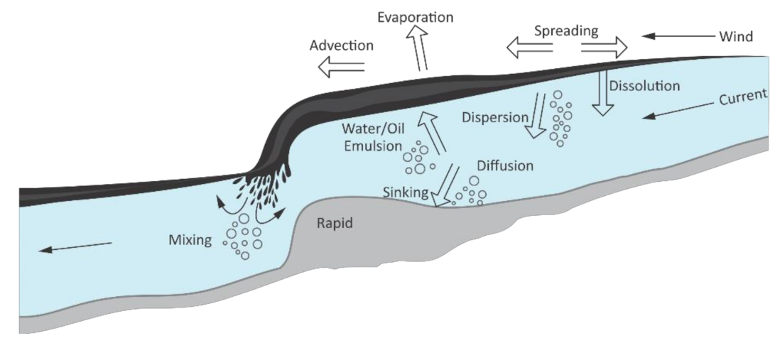
The transport, spreading, and fate of a river oil spill are governed by complex and inter-related physicochemical processes, which depend on the oil properties (e.g., density, viscosity, etc.), river hydraulics (e.g., cross-section velocity distributions, changes in water levels, etc.) and environmental conditions (e.g., temperature, winds, etc.). According to Yapa and Tao Shen [20], the main oil spill processes include: (i) advection due to the river current and wind, (ii) surface spreading, which results from both turbulent diffusion and mechanical spreading due to balance between gravitational, inertia, viscous and surface tension forces, (iii) weathering processes, such as evaporation, emulsification, dissolution, and oxidation, (iv) turbulent mixing over the depth of the river, (v) interaction of oil with particulate matter and river sediment, and (vi) interaction of oil with shoreline. A schematic representation of oil spills in rivers can be seen in Figure 1.
3. Literature Review of River Oil Spill Model Developments and Modeling Studies
A literature review was conducted using the Web of Science, Scopus, and Google Scholar databases, with the following keywords being chosen for literature search: “river oil spill”, “river oil spill model”, “river oil spill modeling”, “river oil spill” AND “model”, “river oil spill” AND “modeling”, “river” AND “oil spill” AND “modeling”. As there was a low number of search results, we have considered all types of readily available literature (i.e., articles, conference papers, etc.) that have been written in English. It should be noted that there is also a considerable amount of “gray” oil spill literature (e.g., AMOP conferences) [4]; however, as these studies are often inaccessible to wider audience, they have not been considered for this review.
In order to be considered for the review, the study had to focus on one of the following: (i) development of river oil spill models or modeling systems, (ii) application of an oil spill model for a river oil spill scenario, with the main goal being a better understanding of a particular river oil spill process or river oil spill modeling in general, and (iii) development of numerical algorithms that consider a particular river oil spill process and could be included in a river oil spill model.
The studies selected for the review can be classified into three categories: (i) development of numerical models, which can model river oil spills in general, (ii) development of decision support systems, which can be used as response, planning, injury assessment, or risk analysis tools, and (iii) applicative and processed-orientated studies, which have focused on a particular feature of river oil spill modeling or a particular physicochemical process associated with oil spills in rivers.
3.1. Development of Numerical Models
Hibbs et al. [22] have developed a simple and easy to use one-dimensional (1D) riverine oil spill model, which calculates the concentration of oil components in both the oil phase and the water phase. The model considers the processes of evaporation, dissolution, volatilization, and longitudinal dispersion and calculates the size and the location of the oil slick as it propagates downstream of the spill location. The proposed model approximates the river as a series of connected “box models”: completely mixed cells that are fixed in position. The transport process is calculated by employing 1D advection–diffusion equation for each compound in the oil, while the concentration of each compound in the oil slick can be expressed as a mole fraction. The developed model requires minimum information on oil properties and river conditions, with the model being readily applicable for simulations in laterally well-mixed rivers.
Hibbs et al. [22] have used their model to investigate the sensitivity of aqueous concentration to small changes in the rate constants. They have noted that the concentration of a compound in the water phase is linked to the compound’s concentration in the oil phase and the compound’s aqueous solubility. In addition, the concentrations in the water phase are also more sensitive to variations in the dissolution rate, while they are less sensitive to variations in the volatilization rate, slick evaporation rate, and longitudinal dispersion. Finally, it has been found that the evaporative loss rate, dissolution loss rate, and volatilization loss rate are all driven by concentration gradients.
Hibbs et al. [23] have developed a model for predicting the aqueous concentrations of sparingly soluble compounds, which are the result of oil, fuel, or chemicals spilled in rivers. The model calculates the concentration of compounds in both the slick and aqueous phase. The developed model is an improved version of the 1D model proposed by Herbes and Yeh [24], with the process of volatilization being added to the list of the considered weathering processes. Thus, the model proposed by Hibbs et al. [23] takes into account the processes of oil spreading and drifting, evaporation, dissolution, volatilization, and longitudinal dispersion. Another model improvement includes treating the oil slick as a series of control volumes on the water surface rather than treating the oil slick as a single compartment, as originally proposed by Herbes and Yeh [24]. The developed 1D model was developed primarily for applications in small, non-navigable rivers and thus assumes a well-mixed cross-section. Therefore, the model is not suited for applications in wider and larger riverine environments.
Hibbs et al. [23] have used their model to simulate a hypothetical spill of jet fuel. They have demonstrated that the compound’s concentration in the aqueous phase is linked to the compound’s concentration in the slick phase. They have also noted that in the early stages of the spill, the more soluble and more volatile compounds exhibit the highest aqueous concentrations, while in the long run less soluble and less volatile compounds reach the highest aqueous concentrations. Finally, it has also been found that the streamwise concentration gradients, which are the results of the rapid evaporation of the more volatile compounds, have an effect on the aqueous concentrations.
Yin et al. [25] have developed an early warning modeling system for tidal river network region, which simulates fate and transport of potential chemical and oil spills. The modeling system is based on 1D hydrodynamic model, which enables the simulation of river flow under artificial irreversible gate operation. Three different water quality models have been developed: oil spill model, hydrophobic chemical model, and hydrophilic chemical model. The developed 1D oil spill model simulates the particle concentration distributions by employing the mass transfer process based on the hydrodynamic model. The developed oil model predicts the horizontal surface spreading of the oil slick and calculates the oil particle concentration distributions in the water body, with the settling velocity of the oil droplets being calculated based on the Stokes equation.
Yin et al. [25] have used their model to simulate a potential oil spill in the Shanghai river network and thus evaluate the developed early warning modeling system. Based on the oil spill scenario, they have noted that the main drivers behind the process of oil spreading are river flow and wind, with concentrations becoming smaller with time due to the oil’s evaporation. Furthermore, they have concluded that the oil dispersed in the water can be excluded from consideration, as the dispersion rate is insignificant compared to other processes.
Goeury et al. [26] have developed a Lagrangian/Eulerian oil spill model within the TELEMAC modeling system [27], with two-dimensional (2D) TELEMAC-2D model providing hydrodynamics for the oil spill model. The Lagrangian approach is used to describe the surface propagation of an oil slick, while the Eulerian advection–diffusion approach is used for water quality simulations, i.e., for estimation of polycyclic aromatic hydrocarbons (PAHs) toxicity. In the developed model, the spilled oil is represented with a set of hydrocarbon particles, where each particle is considered as a mixture of discrete noninteracting hydrocarbon components. Thus, particles are represented by component categories (PAHs), with the fate of each individual component being tracked separately. Each particle is characterized with several properties (e.g., area, mass, barycentric coordinates, physicochemical characteristics), while fractions of the dissolved PAH are represented with a tracer whose mass directly depends on the dissolved mass of oil particles. The developed oil spill model enables the simulation of the main processes that drive the oil spill propagation and weathering: surface spreading, advection, turbulent diffusion, evaporation, dissolution, and volatilization.
Goeury et al. [26] have conducted a series of mesoscale artificial river experiments in order to test the prediction capacity of the PAHs dissolution model. In general, the developed model predicted PAH concentrations reasonably well, with the model results being in the same order of magnitude as the expected results. They have noted that the observed differences between the model results and measurements are due to the absence of hydrocarbon component interactions in the slick, linear hypothesis of PAH probe response in the result treatment, scaling factor, and the difference in the water temperature in river experiment when compared to the temperature used on the calibration of mass transfer coefficients.
3.2. Development of Decision Support Systems
Martin et al. [28] have developed a geographic information system (GIS) based decision support system for managing risks associated with accidental or intentional spill of hazardous substances into a riverine environment. The Spill Management Information System (SMIS) couples database management systems (DBMS) with 2D hydrodynamic model CE-QUAL-W2 and Computer-Aided Management of Emergency Operations (CAMEO) suite [29,30]. In addition, the model is dynamically linked with real-time streamflow and meteorological information, which enables faster and more accurate model predictions. The developed model enables data capturing and editing, preprocessing, and result interpretation, which suggests that SMIS interface can be regarded as a “black-box” application. However, the model’s functionality is based on the premise that validated simulation models are employed for spill analysis, with SIMS requiring calibration and validation of employed modeling routines.
Martin et al. [28] have demonstrated the functionality of the system by simulating a spill of benzene in the Cheatham Reach of the Cumberland River (Tennessee, USA). The river gauge measurements were utilized for calibration of the hydrodynamic model, with the model predictions being in good agreement with the measured values. Based on the spill characteristics, the modelling system provides an animated display of spill progression through the waterway. The authors have noted that the developed model can provide real-time planning and analysis capabilities for response teams, facility operators, and emergency response organizations. Furthermore, SIMS can also help response teams to better define the spill mitigation approaches and planned response activities, which in turn enables better communication of potential problems with stakeholders and decision makers.
Samuels et al. [31] have developed a GIS-based software package called RiverSpill, which calculates time-of-travel and concentration of contaminants (such as oil spills from transportation infrastructure) in riverine environments. The software package has been developed primarily as a response, planning, and decision tool for protection of the water supply systems. The developed model is based on the use of real-time stream flow data, a hydrologically connected stream network, and the locations of the drinking water intake. The time-of-travel is based upon velocity–discharge relationship [32], with the relationship being affirmed by several observational dye studies [33,34,35]. In the model, spills may be modelled as either instantaneous or continuous events. The developed model includes dispersion and decay processes, which are described in detail in Thomann and Mueller [36]. The dispersion process is characterized as 1D turbulent diffusion in constant density flow, where the pollutant concentration is essentially a function of time and distance along the longitudinal axis. For the decay process, only effects of temperature are considered.
Samuels et al. [31] have evaluated their software package by comparing the modelled and observed times-of-travel of peak concentrations, versus the travelled distance. The observed data has been collected during dye experiments [37], and thus 12 different US rivers have been included in the comparison. Altogether, 34 different cases have been examined, which represented more than 100 different travel distances. Based on the produced regression diagram, Samuels et al. [31] reported that there was an excellent agreement between the model predictions and the field measurements. Therefore, it has been concluded that the obtained results support the use of RiverSpill model as a water contamination threat tool. Nonetheless, it should be noted that the developed software package is focused primarily on soluble chemicals; therefore, it does not necessarily mean that the software package can be automatically applied for oil.
Camp et al. [38] have developed an enhanced version of SIMS, with the updated SMIS 2.0 combining GIS spatial environment with 3D hydrodynamic and chemical spill model. A 3D Generalized, Longitudinal-Lateral-Vertical Hydrodynamic, and Transport (GLLVHT) model is used for hydrodynamic calculations, while the Chemical/Oil Spill Impact Model (COSIM) is used for modeling of oil propagation and weathering processes [39]. SIMS 2.0 has been developed to help during the oil response activities by enabling the visualization of the oil slick propagation and identifying of impact locations and potential response resources in the vicinity of the contamination. The authors have demonstrated the use of the system by simulating a number of oil spill scenarios on the Kentucky Lake portion of the Tennessee River, USA, which also included the evaluation of the employment of booms as a protection measure. The authors have noted that the conducted simulations have outlined the usefulness of the model to locate resources for assistance in spill response, with such information potentially being of vital importance for a speedy notification during an oil spill event.
Samuels et al. [40] have developed a global oil spill modeling system, which can be used for real-time response situations, forecast simulations, and probabilistic risk analysis. The ocean and estuarine oil spills are modelled with the GNOME oil spill model [41,42], while the riverine oil spill modeling is based on the GeoSpatial Stream Flow Model (GeoSFM) [43] and the Incident Command Tool for Drinking Water Protection (ICWater), which is structured around RiverSpill software package [31]. The GeoSFM is used to generate river flows and velocities based on the global datasets (e.g., terrain, land use, soils, rainfall, evapotranspiration). The flows and velocities can be adjusted/updated with data from real-time stream flow gauging stations. Once the information on flow and velocities is complete, the data is imported to the ICWater model, which is used to predict the downstream propagation and dispersion of oil.
Jacketti et al. [44] have expanded the open-source Subsurface Oil Simulator (SOSim) model to predict the location and movement of sunken oil in rivers. SOSim is a 2D multi-modal inferential Gaussian model where the general solution of advection–diffusion equation is the premise, while the sunken oil parameters (e.g., velocity, dispersion, number of patches) are inferred as maximum likelihood values from available field data together with the bathymetric data [45]. The applied Gaussian assumption is relaxed, which means that an individual sunken oil patch can have a unique velocity vector, diffusion matrix, and orientation, with parameters being updated regularly as new field data become available. The SOSim model does not incorporate hydrodynamics, since the field observations on the location and concentration of sunken oil reflect current riverine conditions, with these field observations being used in inferring model parameters. As the SOSim has been developed for the marine environment, the model algorithms have been adapted to consider the generally smaller scale of rivers and their unique transport mechanism. Finally, the SOSim has been rewritten as a 1D model to address spills where there are no publicly available bathymetric datasets defining the river boundaries.
Jacketti et al. [44] have first employed the 2D version of model to estimate the movement of sunken oil for the M/T Athos I oil spill, which occurred in the Delaware River (USA) in 2004 and for which field data have been collected. In the next step, the authors have applied the 1D version of the model to estimate the sunken oil characteristics for the 2010 Enbridge Kalamazoo River oil spill, as there was no publicly available bathymetric data to define river boundaries for this event. The reported results suggest that the adapted SOSim model can successfully locate and track sunken oil in small rivers, even in the case where there are limited field observations and bathymetric data. Therefore, the presented model can be used for forecasting the trajectory of relatively slow-moving contaminants in the riverine environments, such as oil at the bottom of a river.
3.3. Applicative and Process-Oriented Studies
In a companion paper to Hibbs et al. [23], Hibbs and Gulliver [46] have run a series of model simulations and analyzed the corresponding results in order to estimate the sensitivity of different model parameters on model predictions of soluble compounds concentrations. It has been found that the model predictions of aqueous concentrations have been most sensitive to the saturation concentrations and the dissolution rates, moderately sensitive to the evaporation rates and longitudinal dispersion coefficient and practically insensitive to the volatilization coefficient. The authors have concluded that the dissolution rate coefficient is the key parameter for predicting the aqueous concentration. However, they have also noted that due to the high uncertainty in values of the dissolution coefficient used in riverine oil spill studies, it is virtually impossible to realistically estimate the aqueous concentrations that result from river oil spills.
Danchuk and Willson [47] have examined the impact of detailed shoreline mapping on the oil spill propagation modeling for a section of the Mississippi River. Five different shoreline types have been mapped, with maps reflecting the impact of different flow rates on a particular shoreline type. An oil spill model has been employed to investigate the effect of applying different refloatation half-lives at different river discharges, with refloatation half-life representing the adhesiveness of the oil to the shoreline as a function of substrate porosity, oil properties, vegetation, and environmental processes. The 2D ADaptive Hydraulics (ADH) model has been used for hydrodynamic calculations [48], while GNOME oil spill model has been used for simulating oil spill trajectories. The authors have noted that the implementation of the detailed shoreline maps has a significant impact on the oil spill model predictions. In addition, it has been concluded that the use of a single refloatation half-live does not adequately represent the sensitivity of the shoreline to oil retention, and that the development of localized, case-specific models provides more realistic results for contingency planning than the application of a generic method or modeling approach.
Perez et al. [49] have developed a novel technique for predicting the amount of oil entrained by suspended sediments in rivers, with the techniques being based on the use of the river’s atmospheric oxygen absorption rates to estimate the surface turbulence. Namely, the authors have hypothesized that the gas transfer velocity (GTV) of atmospheric oxygen into water can be used as a substitute for turbulence in order to extrapolate the laboratory results to real-life river environment. Laboratory experiments have been conducted in order to determine how sediments and oil interact, with two types of experiments being performed to determine (i) the effect of varying sediment concentration on oil entrainment and (ii) the effect of varying turbulence on oil entrainment. The developed technique can estimate the amount of the entrained oil by using GTV measurements or by employing parametric equations for GTV based on river parameters (e.g., slope and discharge rate). In addition, the technique can be used for any type of oil, with the precondition being that the laboratory oil entrainment studies have been performed.
Based on the obtained results, Perez et al. [49] have reported that in very turbulent rapids, approximately 13% of a diluted bitumen slick can be entrained by clay-sized sediments in a period of roughly 10 min, while 80% of a diluted bitumen slick would be entrained in approximately 2 h. The authors have also noted that sediments attached to oil probably remain in suspension until turbulence level drops, with oil–sediment combination later sinking to the bottom of the river. The authors conclude that by using readily available GTV data, the developed technique can be used by oil spill responders to make rapid predictions of quantities of oil entrainment by sediments.
Zhu et al. [50] have developed a three-dimensional (3D) Lagrangian/Eulerian model for oil–particle aggregates (OPA) transport, which employs specified OPA properties that are based on laboratory experiments. The model has been developed for Morrow Lake in the Kalamazoo River (USA), with the model including the Morrow Lake dam operational rules and wind effects. A Lagrangian particle tracking model has been coupled with 3D Eulerian hydrodynamics model, with random walk being used to simulate the OPA movement due to the turbulent diffusion. The 3D Eulerian model calculates the hydrodynamic properties that influence OPA’s advection and diffusion, deposition onto the bed, and resuspension from the bed. The implemented Lagrangian particle tracking model enables the specification of the two key properties related to the OPA transport, i.e., settling velocity and critical bed shear stress for resuspension. The authors have also noted that the developed model is simplified, as it only treats the transport of OPA’s with specified properties.
Zhu et al. [50] have used their model to simulate three different types of OPA transport (i.e., three different types of aggregates with unique settling velocity) within the Morrow Lake in the Kalamazoo River in order to illustrate the appropriateness of the model as a management tool. The obtained results have illustrated the sensitivity of the model to the settling velocity parameter, which indicates that there are inherent uncertainties in OPA properties due to lack of data regarding OPA’s formation and transformation, little understanding of biogeochemical processes that take place once the oiled-sediment resides on the bed for prolonged period of time, and the lack of data that would provide information on the entrainment rate of OPAs separately from the bulk sediment. Nonetheless, the authors have concluded that the developed model can be used as a management tool, as the impoundments in the riverine systems can be used to manage outflow and thus facilitate clean-up activities downstream of the contaminated area.
Jones and Garcia [51] have developed a 1D rapid response model for OPA transport, with the OPA formation and transport being described stochastically with a random walk particle tracking algorithm. In addition to the random walk particle tracking method, the model also includes a coagulation model that describes the formation of the OPAs during their residence time. As model is 1D and meant to be used as a rapid response tool, several assumptions have been made: (i) the oil droplets do not break up or adhere to each other, (ii) particles attaching to the oil droplet cover the droplet uniformly and in a monolayer, (iii) once particles are attached to an oil droplet, they do not detach, (iv) oil droplets and OPAs do not coagulate, (v) sediment particles are not tracked in the model; instead, the suspended sediment concentration is described via Rouse-Vanoni profile, (vi) re-entrainment of the settled OPAs is not considered, and (vii) river is described as a rectangular channel with uniform and steady flow.
Jones and Garcia [51] have first validated the developed model by comparing the model predictions to experimental results [52,53]. In the next step, the authors have altered the model to accept the results from 1D hydraulic HEC-RAS model, with the oil spill model then applied to simulate the 2010 Kalamazoo River oil spill in order to estimate the location and amount of settled oil. The obtained results have shown that (i) the flow velocity has a pivotal role on the temporal dynamic of the OPAs formation and settling out of the water column, (ii) the amount of oil that settles to the bottom depends on the bottom sediment grain size, (iii) the settled oil is in carrying capacity relationship with the sediment diameter, and (iv) the oil density does not have an effect on the settling of the oil out of the water column. In addition, the authors have also noted that the developed model has potential to be used as a screening tool; however, oil droplet breakup and resuspension of settled OPAs should be considered in future riverine oil spill studies.
Wang et al. [54] have investigated the uncertainties associated with the coupling effects between OPAs stochastic formation and transportation processes, with the coagulation conceptual formula and random-walk particle tracking method being employed to understand the heterogeneous behavior of OPAs. The developed scheme has been verified by two numerical experiments. Based on the verification with the experimental data, the authors have determined a vertical diffusivity scheme and the packing coefficient for an oil–sediment interaction model, which have been used to study the density variations and deposition patterns of the hypothetically fully developed OPAs. The obtained results suggest that the OPAs formation process significantly affects the overall longitudinal deposition of OPAs, with the OPAs settling velocity being primarily governed by the size and density of the OPA. Even though this study contributed to a better understanding of some of the factors that control the development of OPAs, the authors have nonetheless noted that the whole process is still not understood due to the lack of laboratory measurements and experimental data.
Adams et al. [7] have assessed whether oil droplets can be carried by hyporheic flows and thus become trapped in the river sediment. A gravel column has been developed to model hyporheic flows, with different types of oil being considered during the experiments in order to determine the potential effect of oil properties on trapping and hydrocarbon dissolution. The study results have shown that the amount of oil trapped in gravel is related to the oil loading and oil viscosity. In addition, the trapped oil acted as a long-term source of hydrocarbons to fish, with the releasing microdroplets being embryotoxic. The authors have noted that their proof-of-concept study strongly indicates that hyporheic flows have the potential to entrain oil droplets, which consequently leads to trapping of oil droplets in pore spaces of river sediments. Therefore, the authors have concluded that these processes should be considered within river oil spill risk assessment and response measures.
3.4. Summary
The main characteristics of the developed numerical models are summarized in Table 1. It can be seen from Table 1 that the developed numerical models have limited potential use and thus generally cannot be used to analyze the entire life cycle of a river oil spill. For example, models developed by Hibbs et al. [22], Hibbs et al. [23], and Yin et al. [25] are all based on 1D modelling concept, which enables the potential model use for only specific problems, e.g., an assessment of the oil slick propagation times between specific points along a river section or an estimation of changes in the oil particle concentrations over time. Even though Yapa and Tao Shen [20] had pointed out that 1D river oil spill models were already out of date at the time they have conducted their state-of-the-art review, these studies have nonetheless highlighted that 1D models can be useful.
On the other hand, the model developed by Goeury et al. [26] has wider application as it is based on 2D Lagrangian/Eulerian modelling approach, which enables the simulation of potential oil spills in both small and large rivers. However, this model also has a limited potential use, as it can simulate only the processes that dominate at the early stage of an oil spill (e.g., spreading, evaporation, dispersion, etc.), while it cannot assess the processes that dominate at the later stages (e.g., sedimentation). In addition, the model developed by Goeury et al. [26] does not consider shoreline interaction or formation and propagation of oil-particle aggregates, which are some of the key processes associated with river oil spills. In a way, the model developed by Goeury et al. [26] is probably more suitable for modeling oil spills in the open sea and large rivers than in small and medium riverine environments.
The higher potential for forming and settling of the oil–sediment aggregates is probably the key characteristic of oil spills in rivers. As it can be seen in Table 1, none of the models developed in the past 30 years considers this process. Therefore, the developed models can simulate processes that are already well-known from the coastal and offshore oil spill modeling, but they cannot assess processes that are highly characteristic for river oil spills, such as OPA formation and transport.
The main characteristics of the developed decision support systems are summarized in Table 2. It can be seen in Table 2 that these systems are built on well-known models and tools, with their main purpose being to assist with a variety of operational and decision-making tasks. Therefore, even though these systems can be regarded as useful support tools, they do not contribute to a better understanding of river oil spill processes, nor do they contribute to the development of better and more accurate river oil spill models or modeling techniques.
As mentioned, rivers’ hydrodynamics can differ quite significantly to coastal and offshore hydrodynamics. Many of the tools incorporated in the considered decision support systems have been developed primarily for oil spills occurring at sea (e.g., COSIM). For rivers with wide channels and large waterbodies (e.g., Lower Mississippi), these systems should work fine. However, the question is how well these systems can simulate the oil spill processes in smaller rivers (i.e., narrower channels with faster flows).
For example, the river flow does not reverse direction, which means that a potential river oil spill can quickly become a very large-scale problem in the downstream direction. Therefore, considering the amount and the required resolution of data that is needed to accurately describe channel geometry and flow conditions, it becomes questionable whether these systems can provide accurate and timely real-time forecasts for smaller river networks.
The main characteristics of the applicative and process-orientated studies are summarized in Table 3. It can be seen from Table 3 that the majority of studies deal with the interaction of oil with river sediment. The information on oil–sediment aggregates quantities and potential locations plays an important role in estimating the long-term environmental impacts and preparing and executing of response and clean-up activities. On the one hand, these studies have provided valuable information and guidelines for future research and development, as well as techniques and tools for practical use. For example, the study by Danchuk and Willson [47] has highlighted the need for implementation of detailed shoreline mapping in order to provide more realistic model results for contingency planning, Perez et al. [49] has provided the oil spill responders with a tool for estimating the amount of oil entrained by suspended sediments in the river, and Zhu et al. [50] have developed a management tool for potential clean-up activities.
On the other hand, however, the outcomes of these studies are generally limited due to simplified study assumptions or case-specific focus. As many authors have noted, far more research is needed to test and improve the proposed solutions in order to obtain more in-depth understanding of river oil spill processes. Even though such studies can be used for specific cases, they do not provide a general solution. Nonetheless, this type of study is very important, as it will not be possible to understand the full picture until the key processes are identified and understood.
4. Discussion and Recommendations
Oil spill research is distinctly episodic and extensively focused on “hyper-spills”, such as Deepwater Horizon oil spill [4]. This means that more common, smaller oil spills are vastly understudied compared to rarer, but highly publicized, larger oil spills. This is particularly evident with river oil spill modeling (and river oil spill research in general), which has received negligible academic attention in the past 30 years compared to the coastal and offshore oil spill modeling and research. For example, there have been nearly as many oil spill remote sensing review papers published in the past three decades as there have been publications on developed or refined river oil spill models [56,57,58,59,60].
Therefore, the main task is to significantly increase both public and academic interest in river oil spill research and modeling in the future. The importance of river oil spill modeling in the context of the environmental and public health protection has to be promoted more rigorously among relevant decision-making authorities and institutions, which would hopefully lead to more research funding becoming available for river oil spill research. More should also be done to raise awareness about the severe lack of studies and new developments within the academic community. For example, no-fee Open Access Special Issues of relevant academic journals could be dedicated to river oil spill research and modeling and thus encourage researchers to get involved in this field of research and tackle the gaps in knowledge.
There has been limited progress in the understanding of the main physicochemical processes associated with river oil spills, such as oil entrainment into the water column, oil breakup within the water column, shoreline deposition and re-entrainment of oil, and interaction between oil droplets and suspended matter (e.g., river sediments). Some processes have received some attention, such as dissolution, formation, and propagation fate of oil-particle aggregates (OPAs) and adherence of oil to shoreline. However, these studies are based on simplified models, e.g., [22,23,50,51], including simplified assumptions or consider only specified properties of the studied process, e.g., [50,54], are adapted to a specific location/study-case, e.g., [47], or are first-of-kind [7], which limits their findings from being more widely applied.
The applicative and process-orientated studies are very important, as it is necessary to first identify and understand the key specific processes. In addition, this type of study can also improve individual aspects of operational and risk assessment modeling, as different activities (e.g., emergency response, response planning, environmental impact assessment, post-impact assessment, etc.) generally have different specific needs from models. Even though the reviewed applicative and process-orientated studies have provided new insights and have contributed to the better understanding of specific river oil spill processes, they nonetheless report the same—far more research is needed in order to draw more concrete conclusions.
The major issue is the lack of experimental data, which could be used to validate developed models and algorithms. Therefore, more experimental studies should be conducted in the future, which should focus on oil slick surface spreading, interaction with shoreline (e.g., accumulation and later potential release), entrainment and breakup of oil droplets in the water column, interaction with sediment, and effect of hyporheic flows. As outlined by studies reviewed in this paper, studies should investigate more in detail the following: oil spreading in the presence of currents (e.g., full coupling of at least two of the three governing processes: hydrodynamic currents, mechanical spreading, and advection–dispersion, depending on the river size and steepness), vertical mixing in the presence of rapids, the impact of wind on spreading in wide rivers and adjustment of wind data, the impact of shoreline deposition and re-entrainment of oil, dissolution modeling (e.g., PAH can be highly toxic for river organisms even in very low concentrations), oil droplet break up, entrainment and settling of OPAs, and trapping of oil in river sediments.
As indicated, all river oil spill processes are generally poorly understood. Nonetheless, the better understanding of entrainment/dispersion of oil droplets in the water column, formation and fate of oil-particle aggregates (OPA), and interaction of oil with shoreline should be considered as a priority in future studies. These processes play the key role in (i) better understanding and predicting of the long-term impacts of river oil spills on the environment and (ii) the extent and duration of the clean-up activities [13,61,62]. Furthermore, these processes are also interrelated, e.g., OPA can lead to more oil being dispersed in the water column [13], while OPA formation and transport is dependent on the shoreline geometry and its sediment characteristics [61]. Understanding the general specifics and interrelations between these processes is the key feature in the better understanding of river oil spills in general.
The novelty in the field of river oil spill modeling presents the development of decision support systems, which have been developed to support during oil spill response activities (e.g., provide real-time forecasts), help with the development of mitigation measures, and assist with post-spill analyses (e.g., preparation of post-impact assessment studies). Even though these systems have great practical value, they generally rely on already developed models and algorithms (e.g., GNOME or COSIM). Hence, these systems have not been developed to provide any new insights or tackle any of the gaps in the knowledge and thus do not contribute to a better understanding of river oil spill processes.
The developed decision support systems often rely on models that have been primarily developed for coastal and offshore environments. For large rivers, these systems probably give satisfactory results. However, it should be investigated how well these systems can simulate the oil spill processes in smaller non-navigable rivers. A considerable amount of high-resolution data is needed to model oil spill events in such river networks. Therefore, future studies should aim to determine whether these systems can provide accurate and timely real-time forecasts for rivers characterized with narrower channels, faster flows, and complex shorelines. Consequently, such studies would also provide more information on river scales that still can be modeled with solutions primarily developed for coastal and offshore applications.
In addition, future studies should also investigate more in detail the importance of model dimensionality within river oil spill studies. For example, “proper” 2D flows can generally be expected only in the largest of rivers (e.g., Mississippi), with full 2D model solutions thus generally being necessary for applications in such river environments. On the other hand, for the vast majority of smaller rivers the hydrodynamic conditions can be described by parametrizing the horizontal (and vertical) direction, with 1D models therefore being sufficient for applications in small, non-navigable channels. However, the question is where the limits of 1D model applications are and when 2D models are really necessary with regard to the river scale. Therefore, future studies should aim to determine when it is necessary to consider models with higher dimensionality (i.e., switch from 1D to 2D model) based on the river characteristics, such as the average channel width and depth, average discharge, channel gradient, channel sinuosity, etc.
Finally, marine oil spill remote sensing has seen significant advances in recent years, with sophisticated cameras and microwave sensors, satellites, radars, and lasers being regularly used to detect and track oil spilled at sea [59]. Even though satellite data can be used to monitor river oil spills [63], it should be investigated more in detail if these sensing techniques can be used to detect or monitor oil spills occurring in smaller rivers. In addition, there are commercially available cameras that have been developed specifically to detect river oil spills [64]. However, these mainly function as an alarm system that alerts the user (e.g., pump station, water treatment plant, etc.) about the presence of oil in water. What is missing is a systematic approach to collect field data that could be used for validation of modelling studies or development of numerical models. Therefore, future studies should focus on the development of remote sensing systems that would not only better detect river oil spills but also enable high-resolution recording of field data.
5. Conclusions
In conclusion, the review has found that there has been a significant lack of academic attention and studies in the field of river oil spill modeling in the past three decades. Consequently, the river oil spill modeling has not fundamentally improved since the last state-of-the-art review. Therefore, the majority of gaps in knowledge still remain, with limited progress being made in better understanding of some of the river oil spill processes, such as formation and propagation of oil-particle aggregates (OPAs).
The main issue presents the lack of available experimental data, which could be used to validate the river oil spill models and process algorithms. Therefore, more experimental studies are needed in order to better understand the river oil spill processes and consequently collect experimental data that could be used to develop, validate, and optimize new models and process algorithms.
Compared to the last state-of-the-art review, the development of decision support systems represents a novelty; they have been developed to enable real-life forecasts and response planning, help with the development of mitigation measures, and assist with post-spill analyses. Even though these systems are useful from an operational point of view, they do not contribute to the better understanding of the river oil spill processes or modeling of river oil spills in general.
Currently, many operational modeling systems employ oil spill models developed primarily for coastal and offshore environments. However, more research is needed to determine whether these oil spill models can adequately simulate propagation and fate of oil spills in small, non-navigable rivers. In addition, future studies should also investigate the importance of model dimensionality with regards to the river size, i.e., where is the limit of the applicability of 1D models and when it is necessary to consider 2D models.
There is a need to collect more field data that could be used for validation of modelling studies and newly developed numerical models. Hence, future studies should also focus on development of remote sensing systems that would enable high-resolution recordings or real-life river oil spills and processing of the collected data.
Many of the river-specific oil processes are generally poorly understood. However, a better understanding of the following three processes should be prioritized in future studies: entrainment/dispersion of oil droplets in the water column, formation and fate of oil-particle aggregates (OPA), and interaction of oil with shoreline. A better understanding of these processes would lead to a better understanding and prediction of long-term impacts of river oil spills on the environment and help with the development of better river oil spill response and clean-up techniques.
Finally, the importance of river oil spill research and modeling in the context of environmental and public health protection should be more actively promoted, which would form the basis for obtaining more research funding and thus more academic attention.
Author Contributions
Conceptualization, D.K. and D.Ž.; methodology, D.K.; validation, D.Ž. and P.B.; investigation, D.K.; writing—original draft preparation, D.K.; writing—review and editing, D.K. and D.Ž.; visualization, D.K.; supervision, P.B. All authors have read and agreed to the published version of the manuscript.
Funding
This research has been conducted within the WACOM project, which is cofunded by the European Regional Development Fund (ERDF) and Instrument for Pre-Accession Assistance (IPA) fund under the umbrella of Danube Transnational Programme. In addition, this research has received partial funding by the Slovenian Research Agency (ARRS) within the Programme P2-0180.
Conflicts of Interest
The authors declare no conflict of interest.
References
- Kingston, P.F. Long-term Environmental Impact of Oil Spills. Spill Sci. Technol. Bull. 2002, 7, 53–61. [Google Scholar] [CrossRef]
- Nelson, J.R.; Grubesic, T.H. Oil spill modeling. Prog. Phys. Geogr. Earth Environ. 2018, 42, 112–127. [Google Scholar] [CrossRef]
- Brkić, D.; Praks, P. Proper Use of Technical Standards in Offshore Petroleum Industry. J. Mar. Sci. Eng. 2020, 8, 555. [Google Scholar] [CrossRef]
- Murphy, D.; Gemmell, B.; Vaccari, L.; Li, C.; Bacosa, H.; Evans, M.; Gemmell, C.; Harvey, T.; Jalali, M.; Niepa, T.H. An in-depth survey of the oil spill literature since 1968: Long term trends and changes since Deepwater Horizon. Mar. Pollut. Bull. 2016, 113, 371–379. [Google Scholar] [CrossRef] [PubMed]
- Stalcup, D.; Yoshioka, G.; Black, E.; Carpenter, M. Comparing Oil Spill Rates Using Different Data Sources. In International Oil Spill Conference Proceedings; American Petroleum Institute: Washington, DC, USA, 2003; Volume 2003, pp. 861–871. [Google Scholar]
- Lee, K.; Boufadel, M.; Chen, B.; Foght, J.; Hodson, P.; Swanson, S.; Venosa, A. Expert Panel Report on the Behaviour and Environmental Impacts of Crude Oil Released into Aqueous Environments; Royal Society of Canada: Ottawa, ON, Canada, 2015. [Google Scholar]
- Adams, J.E.; Brown, R.S.; Hodson, P.V. The bioavailability of oil droplets trapped in river gravel by hyporheic flows. Environ. Pollut. 2021, 269, 116110. [Google Scholar] [CrossRef] [PubMed]
- Jeznach, L.C.; Mohan, A.; Tobiason, J.E.; Reckhow, D.A. Modeling Crude Oil Fate and Transport in Freshwater. Environ. Model. Assess. 2021, 26, 77–87. [Google Scholar] [CrossRef]
- ASCE Task Committee on Modeling of Oil Spills State-of-the-Art Review of Modeling Transport and Fate of Oil Spills. J. Hydraul. Eng. 1996, 122, 594–609. [CrossRef]
- Fingas, M.; Fieldhouse, B.; Mullin, J. Water-in-oil Emulsions Results of Formation Studies and Applicability to Oil Spill Modelling. Spill Sci. Technol. Bull. 1999, 5, 81–91. [Google Scholar] [CrossRef]
- Reed, M.; Johansen, Ø.; Brandvik, P.J.; Daling, P.; Lewis, A.; Fiocco, R.; Mackay, D.; Prentki, R. Oil Spill Modeling towards the Close of the 20th Century: Overview of the State of the Art. Spill Sci. Technol. Bull. 1999, 5, 3–16. [Google Scholar] [CrossRef]
- Fingas, M.; Hollebone, B. Review of behaviour of oil in freezing environments. Mar. Pollut. Bull. 2003, 47, 333–340. [Google Scholar] [CrossRef]
- Sun, J.; Zheng, X. A review of oil-suspended particulate matter aggregation—a natural process of cleansing spilled oil in the aquatic environment. J. Environ. Monit. 2009, 11, 1801–1809. [Google Scholar] [CrossRef]
- Gong, Y.; Zhao, X.; Cai, Z.; O’Reilly, S.; Hao, X.; Zhao, D. A review of oil, dispersed oil and sediment interactions in the aquatic environment: Influence on the fate, transport and remediation of oil spills. Mar. Pollut. Bull. 2014, 79, 16–33. [Google Scholar] [CrossRef] [PubMed]
- Johansen, Ø.; Reed, M.; Bodsberg, N.R. Natural dispersion revisited. Mar. Pollut. Bull. 2015, 93, 20–26. [Google Scholar] [CrossRef]
- Afenyo, M.; Veitch, B.; Khan, F. A state-of-the-art review of fate and transport of oil spills in open and ice-covered water. Ocean Eng. 2016, 119, 233–248. [Google Scholar] [CrossRef]
- Spaulding, M.L. State of the art review and future directions in oil spill modeling. Mar. Pollut. Bull. 2017, 115, 7–19. [Google Scholar] [CrossRef]
- Nissanka, I.D.; Yapa, P.D. Calculation of oil droplet size distribution in ocean oil spills: A review. Mar. Pollut. Bull. 2018, 135, 723–734. [Google Scholar] [CrossRef] [PubMed]
- Keramea, P.; Spanoudaki, K.; Zodiatis, G.; Gikas, G.; Sylaios, G. Oil Spill Modeling: A Critical Review on Current Trends, Perspectives, and Challenges. J. Mar. Sci. Eng. 2021, 9, 181. [Google Scholar] [CrossRef]
- Yapa, P.D.; Shen, H.T. Modelling river oil spills: A review. J. Hydraul. Res. 1994, 32, 765–782. [Google Scholar] [CrossRef]
- NOAA. How Is an Oil Spill in a River Different than One in the Ocean? Available online: https://response.restoration.noaa.gov/about/media/how-oil-spill-river-different-one-ocean.html (accessed on 2 February 2021).
- Hibbs, D.E.; Chen, Y.-F.; Gulliver, J.S.; Voller, V.R. A TWO-PHASE RIVERINE SPILL MODEL. In International Oil Spill Conference Proceedings; American Petroleum Institute: Washington, DC, USA, 1997; Volume 1997, pp. 567–571. [Google Scholar]
- E Hibbs, D.; Gulliver, J.; Voller, V.R.; Chen, Y.-F. An aqueous concentration model for riverine spills. J. Hazard. Mater. 1999, 64, 37–53. [Google Scholar] [CrossRef]
- Herbes, S.E.; Yeh, G.-T. A transport model for water-soluble constituents of synthetic oil spills in rivers. Environ. Toxicol. Chem. 1985, 4, 241–254. [Google Scholar] [CrossRef]
- Yin, H.-L.; Xu, Z.-X.; Wang, C.; Yu, D. Development of early warning modeling system for sudden chemical spill in plain river network. J. Mar. Sci. Technol. 2011, 19, 634–642. [Google Scholar]
- Goeury, C.; Hervouet, J.-M.; Baudin-Bizien, I.; Thouvenel, F. A Lagrangian/Eulerian oil spill model for continental waters. J. Hydraul. Res. 2014, 52, 36–48. [Google Scholar] [CrossRef]
- Hervouet, J.M. TELEMAC modelling system: An overview. Hydrol. Process. 2000, 14, 2209–2210. [Google Scholar] [CrossRef]
- Martin, P.H.; Leboeuf, E.J.; Daniel, E.B.; Dobbins, J.P.; Abkowitz, M.D. Development of a GIS-based Spill Management Information System. J. Hazard. Mater. 2004, 112, 239–252. [Google Scholar] [CrossRef] [PubMed]
- Haas, T.J. CAMEO—Valdez: Charting the Progress of the Spill Cleanup. In International Oil Spill Conference Proceedings; American Petroleum Institute: Washington, DC, USA, 1991; Volume 1991, pp. 655–658. [Google Scholar]
- Cole, T.M.; Wells, S.A. Two-Dimensional, Laterally Averaged, Hydrodynamic and Water Quality Model, Version 3.1; US Army Engineering and Research Development Center: Vicksburg, MS, USA, 2002; p. 120. [Google Scholar]
- Samuels, W.B.; Amstutz, D.E.; Bahadur, R.; Pickus, J.M. RiverSpill: A National Application for Drinking Water Protection. J. Hydraul. Eng. 2006, 132, 393–403. [Google Scholar] [CrossRef]
- Leopold, L.B.; Maddock, T., Jr. The Hydraulic Geometry of Stream Channels and Some Physiographic Implications; Professional Paper; US Government Printing Office: Washington, DC, USA, 1953; p. 57.
- Kilpatrick, F.; Wilson, J.F. Measurement of Time of Travel in Streams by Dye Tracing; US Government Printing Office: Washington, DC, USA, 1989; Volume 3. [Google Scholar]
- Lee, K.K. Stream velocity and dispersion characteristics determined by dye-tracer studies on selected stream reaches in the Willamette River basin, Oregon. In Stream Velocity and Dispersion Characteristics Determined by Dye-Tracer Studies on Selected Stream Reaches in the Willamette River Basin, Oregon; US Geological Survey: Reston, VA, USA, 1995; p. 48. [Google Scholar]
- Jobson, H.E. Predicting Travel Time and Dispersion in Rivers and Streams. J. Hydraul. Eng. 1997, 123, 971–978. [Google Scholar] [CrossRef]
- Thomann, R.V.; Mueller, J.A. Principles of Surface Water Quality Modeling and Control; Harper & Row Publishers: New York, NY, USA, 1987; p. 644. [Google Scholar]
- Jobson, H.E. Prediction of Traveltime and Longitudinal Dispersion in Rivers and Streams; United States Geological Survey: Reston, VA, USA, 1996. [Google Scholar]
- Camp, J.S.; Leboeuf, E.J.; Abkowitz, M.D. Application of an enhanced spill management information system to inland waterways. J. Hazard. Mater. 2010, 175, 583–592. [Google Scholar] [CrossRef] [PubMed]
- Camp, J.V.; Abkowitz, M.D.; Leboeuf, E.J. Inland waterway resource and spill management needs in Southeastern USA. Disaster Prev. Manag. Int. J. 2010, 19, 483–497. [Google Scholar] [CrossRef]
- Samuels, W.B.; Amstutz, D.E.; Bahadur, R.; Ziemniak, C. Development of a Global Oil Spill Modeling System. Earth Sci. Res. 2012, 2, 52. [Google Scholar] [CrossRef] [Green Version]
- Beegle-Krause, C. GNOME: NOAA’s next-generation spill trajectory model. In Proceedings of the Oceans ’99. MTS/IEEE. Riding the Crest into the 21st Century. Conference and Exhibition. Conference Proceedings (IEEE Cat. No.99CH37008), Seattle, WA, USA, 13–16 September 1999. [Google Scholar]
- Beegle-Krause, J. GENERAL NOAA OIL MODELING ENVIRONMENT (GNOME): A NEW SPILL TRAJECTORY MODEL. In International Oil Spill Conference Proceedings; American Petroleum Institute: Washington, DC, USA, 2001; Volume 2001, pp. 865–871. [Google Scholar]
- Artan, G.A.; Asante, K.; Smith, J.; Pervez, S.; Entenmann, D.; Verdin, J.P.; Rowland, J. User’s Manual for the Geospatial Stream Flow Model (GeoSFM). Open-File Rep. 2008, 146. [Google Scholar] [CrossRef]
- Jacketti, M.; Englehardt, J.D.; Beegle-Krause, C. Application of the SOSim v2 Model to Spills of Sunken Oil in Rivers. J. Mar. Sci. Eng. 2020, 8, 729. [Google Scholar] [CrossRef]
- Echavarria-Gregory, M.A.; Englehardt, J.D. A predictive Bayesian data-derived multi-modal Gaussian model of sunken oil mass. Environ. Model. Softw. 2015, 69, 1–13. [Google Scholar] [CrossRef]
- E Hibbs, D.; Gulliver, J. Processes controlling aqueous concentrations for riverine spills. J. Hazard. Mater. 1999, 64, 57–73. [Google Scholar] [CrossRef]
- Danchuk, S.; Willson, C.S. Effects of shoreline sensitivity on oil spill trajectory modeling of the Lower Mississippi River. Environ. Sci. Pollut. Res. 2009, 17, 331–340. [Google Scholar] [CrossRef]
- Savant, G.; Berger, C.; McAlpin, T.O.; Tate, J.N. Efficient Implicit Finite-Element Hydrodynamic Model for Dam and Levee Breach. J. Hydraul. Eng. 2011, 137, 1005–1018. [Google Scholar] [CrossRef]
- Perez, S.; Furlan, P.; Ellenberger, S.; Banker, P. Estimating diluted bitumen entrained by suspended sediments in river rapids using O2 absorption rate. Int. J. Environ. Sci. Technol. 2015, 13, 403–412. [Google Scholar] [CrossRef]
- Zhu, Z.; Waterman, D.M.; Garcia, M.H. Modeling the transport of oil–particle aggregates resulting from an oil spill in a freshwater environment. Environ. Fluid Mech. 2018, 18, 967–984. [Google Scholar] [CrossRef]
- Jones, L.; Garcia, M.H. Development of a Rapid Response Riverine Oil–Particle Aggregate Formation, Transport, and Fate Model. J. Environ. Eng. 2018, 144, 04018125. [Google Scholar] [CrossRef]
- Tang, M.; Huang, D.; Huang, L.; Xiang, F.; Yin, W. Preliminary forecast of hydraulic characteristic test of grass, green, silver carp, bighead carp egg incubation conditions in the Three Gorges Reservoir Area. Reserv. Fish. 1989, 4, 26–30. (In Chinese) [Google Scholar]
- Sun, J.; Khelifa, A.; Zheng, X.; Wang, Z.; So, L.L.; Wong, S.; Yang, C.; Fieldhouse, B. A laboratory study on the kinetics of the formation of oil-suspended particulate matter aggregates using the NIST-1941b sediment. Mar. Pollut. Bull. 2010, 60, 1701–1707. [Google Scholar] [CrossRef]
- Wang, S.; Yang, Y.; Zhu, Z.; Jin, L.; Ou, S. Riverine deposition pattern of oil–particle aggregates considering the coagulation effect. Sci. Total. Environ. 2020, 739, 140371. [Google Scholar] [CrossRef] [PubMed]
- Fay, J.A. Physical processes in the spread of oil on a water surface. In International Oil Spill Conference; American Petroleum Institute: Washington, DC, USA, 1971; Volume 1971, pp. 463–467. [Google Scholar]
- Fingas, M.F.; Brown, C.E. Review of oil spill remote sensing. Spill Sci. Technol. Bull. 1997, 4, 199–208. [Google Scholar] [CrossRef] [Green Version]
- Leifer, I.; Lehr, W.J.; Simecek-Beatty, D.; Bradley, E.; Clark, R.; Dennison, P.; Hu, Y.; Matheson, S.; Jones, C.E.; Holt, B.; et al. State of the art satellite and airborne marine oil spill remote sensing: Application to the BP Deepwater Horizon oil spill. Remote. Sens. Environ. 2012, 124, 185–209. [Google Scholar] [CrossRef] [Green Version]
- Fingas, M.; Brown, C. Review of oil spill remote sensing. Mar. Pollut. Bull. 2014, 83, 9–23. [Google Scholar] [CrossRef] [PubMed] [Green Version]
- Fingas, M.; Brown, C.E. A Review of Oil Spill Remote Sensing. Sensors 2017, 18, 91. [Google Scholar] [CrossRef] [Green Version]
- Al-Ruzouq, R.; Gibril, M.; Shanableh, A.; Kais, A.; Hamed, O.; Al-Mansoori, S.; Khalil, M. Sensors, Features, and Machine Learning for Oil Spill Detection and Monitoring: A Review. Remote. Sens. 2020, 12, 3338. [Google Scholar] [CrossRef]
- Fitzpatrick, F.A.; Boufadel, M.C.; Johnson, R.; Lee, K.W.; Graan, T.P.; Bejarano, A.C.; Zhu, Z.; Waterman, D.; Capone, D.M.; Hayter, E.; et al. Oil-particle interactions and submergence from crude oil spills in marine and freshwater environments: Review of the science and future research needs. In Open-File Report; US Geological Survey: Reston, VA, USA, 2015; p. 33. [Google Scholar]
- Cui, F.; Geng, X.; Robinson, B.; King, T.; Lee, K.; Boufadel, M.C. Oil Droplet Dispersion under a Deep-Water Plunging Breaker: Experimental Measurement and Numerical Modeling. J. Mar. Sci. Eng. 2020, 8, 230. [Google Scholar] [CrossRef] [Green Version]
- Rajendran, S.; Sadooni, F.N.; Al-Kuwari, H.A.-S.; Oleg, A.; Govil, H.; Nasir, S.; Vethamony, P. Monitoring oil spill in Norilsk, Russia using satellite data. Sci. Rep. 2021, 11, 1–20. [Google Scholar] [CrossRef] [PubMed]
- LDI. ROW: Oil Spill Detector. Available online: https://ldi.ee/products/row-oil-detector/ (accessed on 14 May 2021).
Figure 1.
Oil spills in rivers.

Table 1.
Development of numerical models.
| Study | Study Type | Hydrodynamic Model | Oil Spill Model/Oil Propagation Computation | Additional Models/Schemes | Considered Physicochemical Processes | Other Data | Dynamically Linked/Coupled | Validation | Potential Model Use |
|---|---|---|---|---|---|---|---|---|---|
| Hibbs et al. [22] | development of 1D riverine oil spill model | no | based on Fay’s equations [55] | no | advection–diffusion; spreading; evaporation; dissolution; dispersion; volatilization | river data | no | no | estimation of oil slick location and concentrations of compounds in a small, non-navigable river |
| Hibbs et al. [23] | development of 1D riverine oil spill model | no | based on Fay’s equations [55] | no | advection–diffusion; spreading; evaporation; dissolution; dispersion; volatilization | river data | no | no | estimation of oil slick location and concentrations of compounds in a small, non-navigable river |
| Yin et al. [25] | development of 1D riverine oil spill model | 1D Saint-Venant model | based on mass transfer principle | oil settling based on Stokes’ law | advection–diffusion; spreading; evaporation; dissolution; dispersion | no | no | Shanghai river (hydrodynamics only) | estimation of surface oil slick location and oil particle concentration distributions in a river network system |
| Goeury et al. [26] | development of 2D Lagrangi-an/Eulerian oil spill model | 2D depth-averaged model (i.e., TELEMAC-2D) | Lagrangian scheme | Eulerian advection–diffusion scheme | advection–diffusion; spreading; evaporation; dissolution; dispersion; volatilization | no | no | experimental data; field measurements | estimation of the oil slick propagation and location, and simulation of the main processes driving the oil plume |
Table 2.
Development of decision support systems.
| Study | Study Type | Hydrodynamic Model | Oil Spill Model | Additional Modeling Suites/Schemes | Considered Physicochemical Processes | Other Data/Databases | Dynamically Linked/Coupled | Validation | Potential System Use |
|---|---|---|---|---|---|---|---|---|---|
| Martin et al. [28] | development of GIS-based decision support system | 2D CE-QUAL-W2 model | no | CAMEO | dispersion | GIS; real-time streamflow data; meteorological data | yes | measured hydrodynamics and water quality parameters | real-time forecasts and response planning |
| Samuels et al. [31] | development of GIS-based decision support system | no | no | velocity–discharge relationship for time-of-travel calculations | dispersion | GIS; real-time streamflow data; water intake locations | yes | experimental data | real-time forecasts |
| Camp et al. [38] | development of GIS-based decision support system | 3D Generalized, Longitudinal-Lateral-Vertical Hydrodynamic and Transport (GLLVHT) model | Chemical/Oil Spill Impact Model (COSIM) | no | advection–diffusion; spreading; evaporation; dissolution; dispersion; volatilization; emulsification; entrainment; shoreline interaction; sedimentation; sinking | GIS | no | no | development of mitigations measures |
| Samuels et al. [40] | development of GIS-based decision support system | GeoSpatial Stream Flow Model (GeoSFM) | Incident Command Tool for Drinking Water Protection (ICWater) | no | dispersion | GIS; real-time stream flow data | yes | no | real-time forecasts and response planning |
| Jacketti et al. [44] | development of Bayesian based decision support system | no | 1D advection–diffusion equation | no | sinking | GIS; field observations | no | field measurements (pooling data) | post-impact assessment |
Table 3.
Applicative and process-oriented studies.
| Study | Study Type | Hydrodynamic Model | Oil Spill Model | Additional Models/Schemes | River Oil Spill Process in Focus | Other Data/Information | Dynamically Linked/Coupled | Application/ Validation | Study Focus |
|---|---|---|---|---|---|---|---|---|---|
| Hibbs and Gulliver [46] | applicative | no | 1D model presented in Hibbs et al. [23] | no | dissolution | no | no | hypothetical spill | sensitivity of different model parameters on model predictions of soluble compounds concentrations |
| Danchuk and Willson [47] | applicative | 2D ADaptive Hydraulics (ADH) model | GNOME | no | shoreline interaction | no | no | Mississippi River | impact of detailed shoreline mapping on the oil spill propagation modeling |
| Perez et al. [49] | process-orientated | no | no | no | oil entrainment by sediments | experimental study | no | experimental data | development of a technique for estimating the amount of oil entrained by suspended sediments |
| Zhu et al. [50] | process-orientated | 3D Eulerian hydrodynamic model (i.e., Environmental Fluid Dynamics Code - EFDC) | no | Lagrangian particle tracking model for OPAs | OPA formation and transport | no | no | field measurements for hydrodynamic model; experimental data | development of 3D Lagrangian/Eulerian model for OPA transport |
| Jones and Garcia [51] | process-orientated | no | no | random walk particle tracking for OPA transport; coagulation model for OPA formation | OPA formation and transport | accepts results from a steady-flow 1D hydraulic HEC-RAS model | no | experimental data | development of 1D rapid response model for OPA transport |
| Wang et al. [54] | process-orientated | no | no | coagulation conceptual formula; random-walk particle tracking method | OPA formation and propagation | no | no | experimental data | uncertainties associated with the coupling effects between OPAs stochastic formation and transportation processes |
| Adams et al. [7] | process-orientated | no | no | gravel column | oil droplet entrainment due to hyporheic flow | proof-of-concept study | no | experimental data | tendency of oil droplets to be carried by hyporheic flows and thus becoming trapped in the river sediment |
Publisher’s Note: MDPI stays neutral with regard to jurisdictional claims in published maps and institutional affiliations. |
© 2021 by the authors. Licensee MDPI, Basel, Switzerland. This article is an open access article distributed under the terms and conditions of the Creative Commons Attribution (CC BY) license (https://creativecommons.org/licenses/by/4.0/).
Share and Cite
MDPI and ACS Style
Kvočka, D.; Žagar, D.; Banovec, P. A Review of River Oil Spill Modeling. Water 2021, 13, 1620. https://doi.org/10.3390/w13121620
AMA Style
Kvočka D, Žagar D, Banovec P. A Review of River Oil Spill Modeling. Water. 2021; 13(12):1620. https://doi.org/10.3390/w13121620
Chicago/Turabian StyleKvočka, Davor, Dušan Žagar, and Primož Banovec. 2021. "A Review of River Oil Spill Modeling" Water 13, no. 12: 1620. https://doi.org/10.3390/w13121620
Note that from the first issue of 2016, this journal uses article numbers instead of page numbers. See further details here.