1. Introduction
There are many definitions of drought. In general, drought is a natural phenomenon that water resources in a certain region are in short supply due to the uneven spatial and temporal distribution of water resources. Drought disasters occur in a wide range and high frequency, and the damage and losses caused by them will seriously hinder the socioeconomic, agricultural development and ecological environment construction of the country and region [
1,
2,
3]. In recent years, global warming has had a great impact on the environment and climate. The Fourth Assessment Report of the Intergovernmental Panel on Climate Change in 2007 pointed out that global warming will continuously aggravate extreme hydrological events such as drought and flood disasters, and the risk of drought disasters will also continue to increase [
4]. The abnormal SST in the tropical Indo-Pacific Ocean led to severe drought in Northeast Asia in the summer of 2014 [
5], and severe drought continued to occur in southwest China in the summer, autumn and winter of 2009, leading to a serious shortage of water resources, causing significant economic losses and seriously affecting people’s lives [
6]. The frequency and the regularity of drought in the region has very important practical significance.
Drought index is the basis of quantitative study on the occurrence and development of drought. Many scholars use drought indicators such as Palmer Drought Index (PDSI) [
7,
8], Standardized Precipitation Index (SPI) [
9,
10], Precipitation Anomaly (PA) [
11], Standardized Evapotranspiration Index (SPEI) [
12,
13] and Comprehensive Meteorological Drought Index (CI) [
14] to analyze the characteristics and rules of drought occurrence. At present, the research on drought events mainly focuses on the single factor analysis of drought duration and drought intensity, but the complexity and the huge degree of drought disasters cannot be fully described. Therefore, it is necessary to analyze multiple characteristic variables of drought events, such as drought duration, drought intensity, drought area, and intensity peak, etc. Each characteristic variable of drought has a certain correlation. Only by selecting multiple drought variables for simultaneous analysis can drought events be better described [
15,
16,
17,
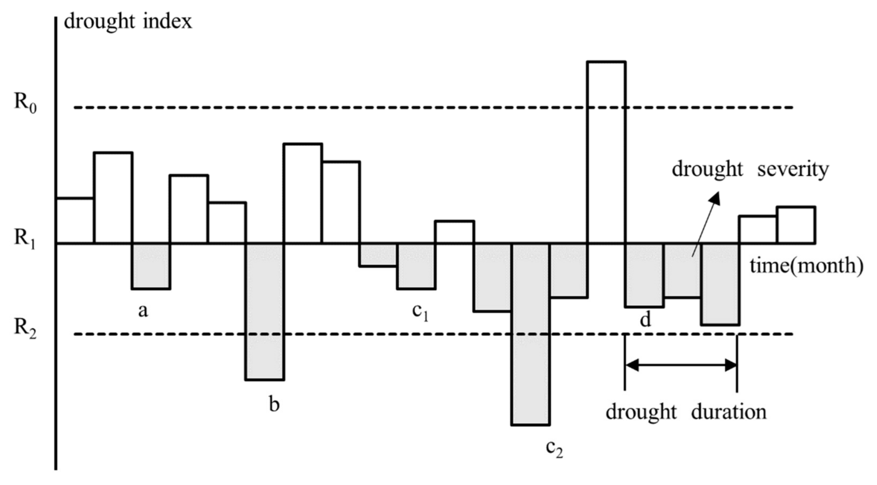
18]. There are many methods for the identification of drought characteristic variables, among which the most widely used method is the theory of running distance. Precipitation data is a typical time series, and the run theory can be used to analyze the discrete stochastic process well [
19,
20,
21]. Herbst et al. [
22] were the first to use the run theory and monthly precipitation data to identify drought characteristics. In the process of identification of the drought event with the run theory, precise control of truncation level is needed, otherwise it will lead to inaccurate identification of drought events [
23]. Therefore, it is necessary to set multiple accurate interception levels to improve the accuracy of drought event identification.
Copula function is used for joint analysis of several drought characteristic variables with correlation. Copula function has been widely used in the study of drought disaster [
24], flood disaster [
25], rainstorm disaster [
26] and other meteorological disasters. Its theoretical basis was first proposed by Sklar [
27], which can well describe the correlation between two variables. Bahram Saghafian et al. [
15] use copula function to analyze the characteristics of groundwater drought, monitor groundwater drought through standardized groundwater index (SGI), and determine the probability and return period of multivariable groundwater drought through copula function. Foo Hui-mean et al. [
28] extracted the three characteristic variables of drought severity, duration and peak severity, and analyzed the occurrence frequency of drought events in the peninsula of Malaysia using the joint distribution of three-dimensional copula model. Copula function can carry out joint distribution of drought variables and describe the complexity and variability of drought events more accurately. However, in the existing studies, the copula function has been studied more in hydrological drought and meteorological drought, but less in the field of agricultural drought. Meanwhile, China is a large agricultural country, and the frequent occurrence of drought disasters has a great impact on the agricultural development of China. Therefore, the accurate analysis of agricultural drought in the region is very important.
Shaanxi north–south across half wet and dry climate zone, is a typical ecologically fragile area, in addition, central Shaanxi Qinling as a natural ecological barrier, south and north climate in China have a significant impact, under the background of global climate change, environmental, Qinling mountains north and south of climate change have become hot topics in the study of many scholars [
29,
30,
31]. In the northern part of Shaanxi, there are mainly two municipal districts, namely Yulin and Yan’an. Northern Shaanxi is a typical dry farming area, located in the middle latitude inland, the northern and northwestern parts of the region belong to the semiarid monsoon climate type, the central and southern parts belong to the warm temperate semiarid monsoon climate type. The terrain of northern Shaanxi is high in the northwest and low in the southeast. The northern part is aeolian landform and beach land, the central part is loess hilly and gully region, and the southern part is the gully and gully region of the Weibei Plateau. The temperature and rainfall decrease from southeast to northwest. Therefore, the climate characteristics in this region have obvious spatial differences, leading to the frequent occurrence of drought events, which seriously hinders the development of agriculture and economy in Northern Shaanxi. Run theory and the joint distribution function of copula to are used analyze the law of drought frequency and drought return period in Northern Shaanxi, which provide reference for the formulation of drought resistance strategies in this area.
2. Study Area and Data
Shaanxi Province is located in the middle latitudes of Northwest China and the northeast side of Qinghai Tibet Plateau, with a long and narrow area of 870 km from north to South and 360 km from east to west, covering a total area of 20.58 × 10
4 km
2. The landform of the whole province can be divided into three parts: the Loess Plateau in Northern Shaanxi (the sandy area along the great wall and the hilly and gully area in Southern Shaanxi), the Guanzhong Plain (the Weibei channel and Weibei plateau) and the Qinba Mountain landform in southern Shaanxi [
32]. The study area is located in the Loess Plateau of Northern Shaanxi, namely Yulin and Yan’an. It belongs to the temperate continental monsoon climate, the average annual precipitation is about 300–700 mm, and the seasonal variation is obvious, and the precipitation is mainly concentrated in summer. Drought events occur frequently [
33,
34].
In this study, daily data, including precipitation, maximum temperature, minimum temperature and sunshine hours, from 10 meteorological stations in the northern part of Shaanxi Province were used.
Figure 1 shows the spatial distribution of 10 meteorological stations in Northern Shaanxi. The time scale was 1960–2019, and the data was provided by the China Meteorological Data Network. The information of agricultural drought disaster is from China Meteorological Disaster Ceremony—Shaanxi Province.
5. Discussion
This paper studies the spatial distribution of drought frequency, the joint probability distribution of drought duration and drought intensity, the return period and the application of the return period in agrometeorological disasters in Northern Shaanxi. The results showed that the probability of drought events with long duration low intensity, short duration high intensity or short duration low intensity in Northern Shaanxi was higher, and Yuyang District and Baota District had high risk of drought, which was consistent with the results obtained by Wang Xiaofeng et al. [
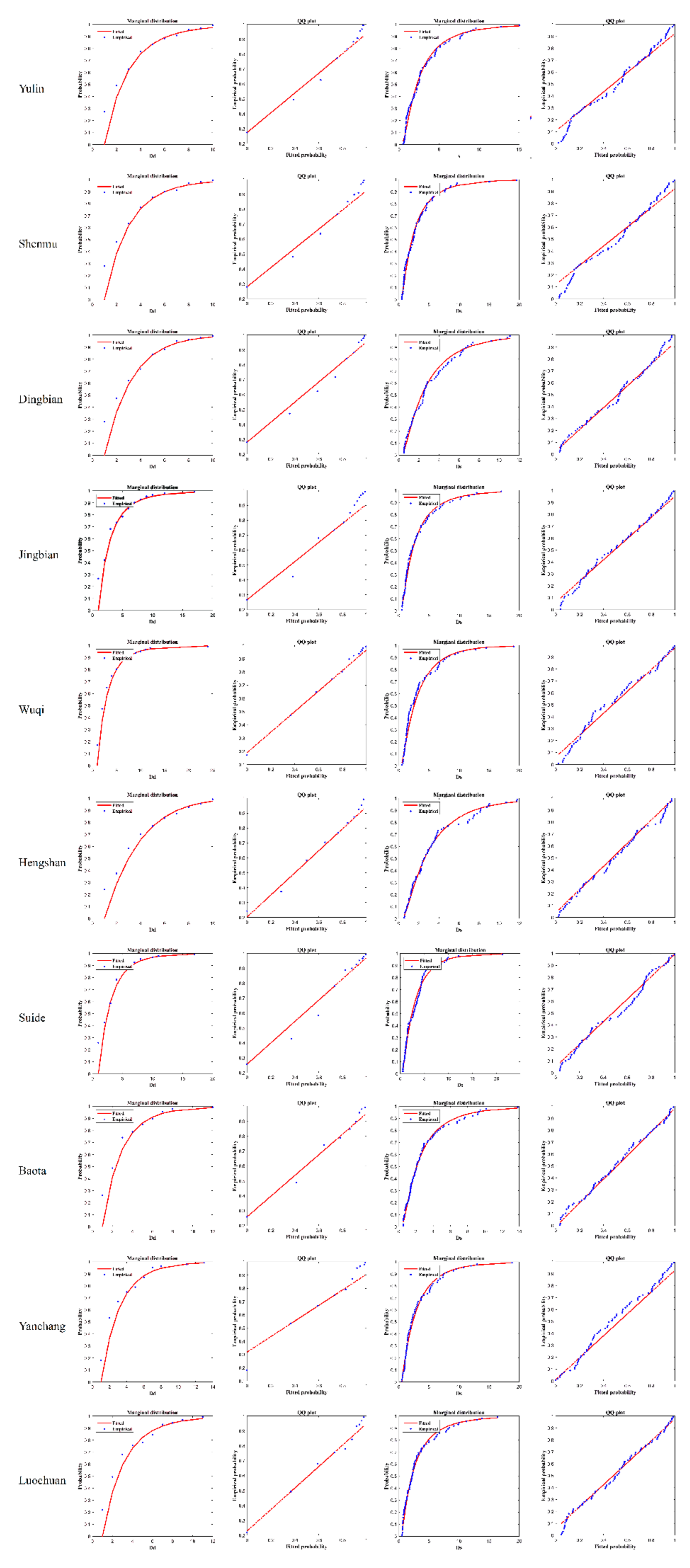
23] in the analysis of drought characteristics in Northern Shaanxi. The results show that it is reliable to extract the drought characteristics by using the theory of running distance and to analyze the regional drought characteristics by using the copula function to carry out joint probability distribution.
In the research process, how to select the drought index and how to set the truncation level of the drought index are very important. However, the setting of the threshold of truncation level in the theory of run length is uncertain, and the threshold of truncation level will change with the difference of drought index and region. The drought index selected in this paper is the standardized precipitation index, which has the advantages of simple calculation, wide application and strong applicability. However, at present, the identification of characteristic variables of drought events mostly adopts a single threshold of truncation level, and the accuracy of the identification of drought events is low [
41,
42,
43]. In this study, three truncation levels were set based on previous experience and trial-and-error method, combined with actual disaster conditions, to improve the accuracy of drought event identification and drought feature extraction. However, drought index selection is single, the subsequent remains to be improved.
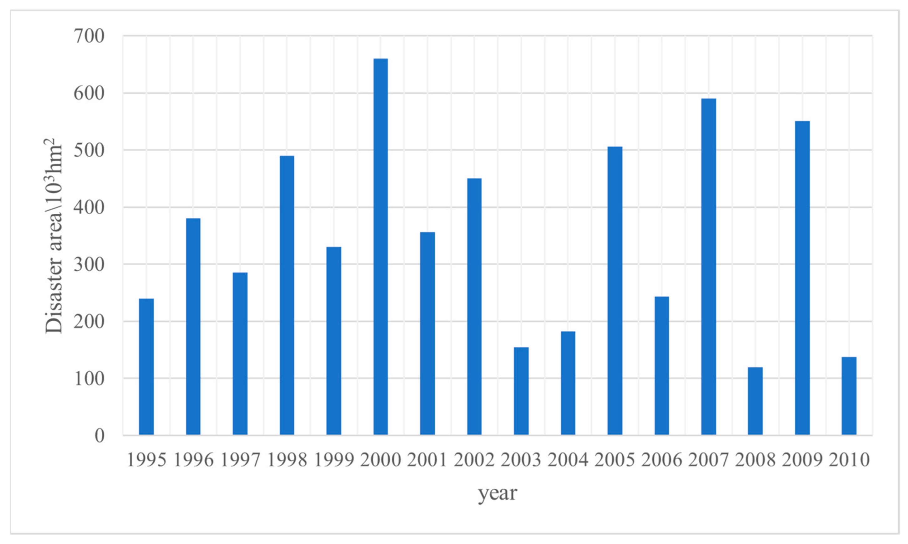
At present, most of the research studies hydrological and meteorological drought using copula function, and seldom combine the research results with crop data [
44,
45]. The annual drought disaster in China leads to severe grain production, so it is urgent to further study regional agricultural drought [
46]. Based on the analysis of drought frequency, joint probability distribution and return period in Northern Shaanxi, this paper further combined with crop affected area, and found that the analysis results could accurately reflect the grade and return period of agricultural drought events. However, the meteorological disasters that have a greater impact on crop yield are also flood disasters. The combination of drought and flood disasters and the rapid transfer of drought and flood increase crop losses. This direction is the key of the follow-up study.
In this paper, the research results of agricultural drought disaster prevention and control of the north of Shaanxi, assessment and management provides a good reference basis. The method can also be applied to the drought research in other regions of the world. For the regions with similar climatic characteristics and topography, our research results can provide reference for the drought research in this area.
6. Conclusions
Through the calculation of monthly precipitation data, the standardized precipitation index series was obtained, and the characteristic variables of drought events were extracted from SPI3 series by using the run-length theory. Then the copula function was used to carry out the joint probability distribution of drought intensity and drought duration, and the joint cumulative probability and return period were obtained. By comparing the results with the affected area of crops, the accuracy and applicability of the results were determined, and finally the following conclusions were drawn:
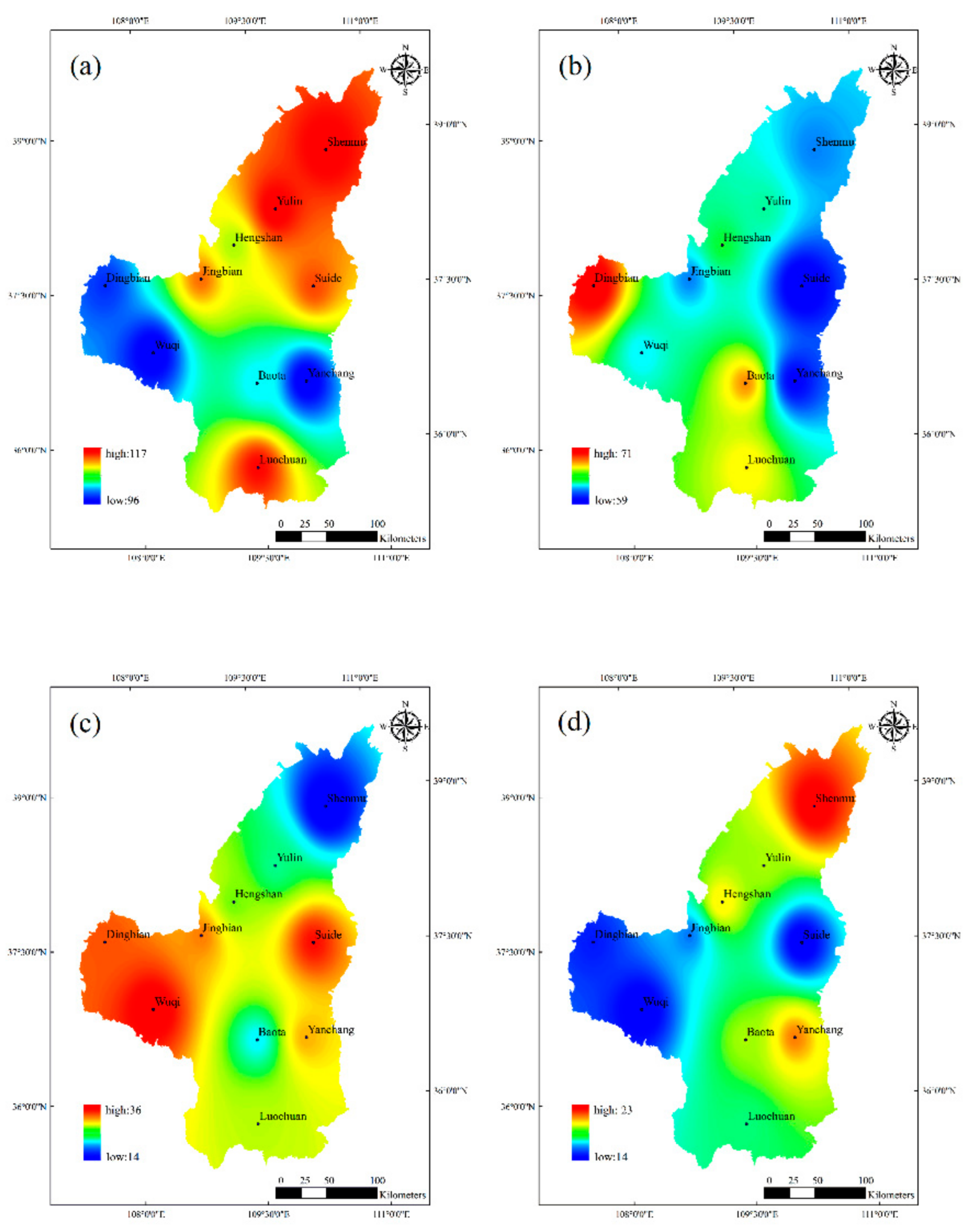
(1) From 1961 to 2019, the average frequency of mild drought in the southern part of the study area was 114, and the average frequency of mild drought in the northern part was 102. The average frequency of moderate drought in the southern part of the study area was 62, and the average frequency of moderate drought in the northern part was 67. The average frequency of severe drought in the southern part of the study area was 26 times, and the average frequency of severe drought in the northern part was 29 times. The average frequency of extreme drought in the southern part of the study area was 18 times, and the average frequency of extreme drought in the northern part was 17 times. The probability of drought events with long duration and low intensity, short duration and high intensity or short duration and low intensity in the whole Northern Shaanxi is higher, which is more than 75%.
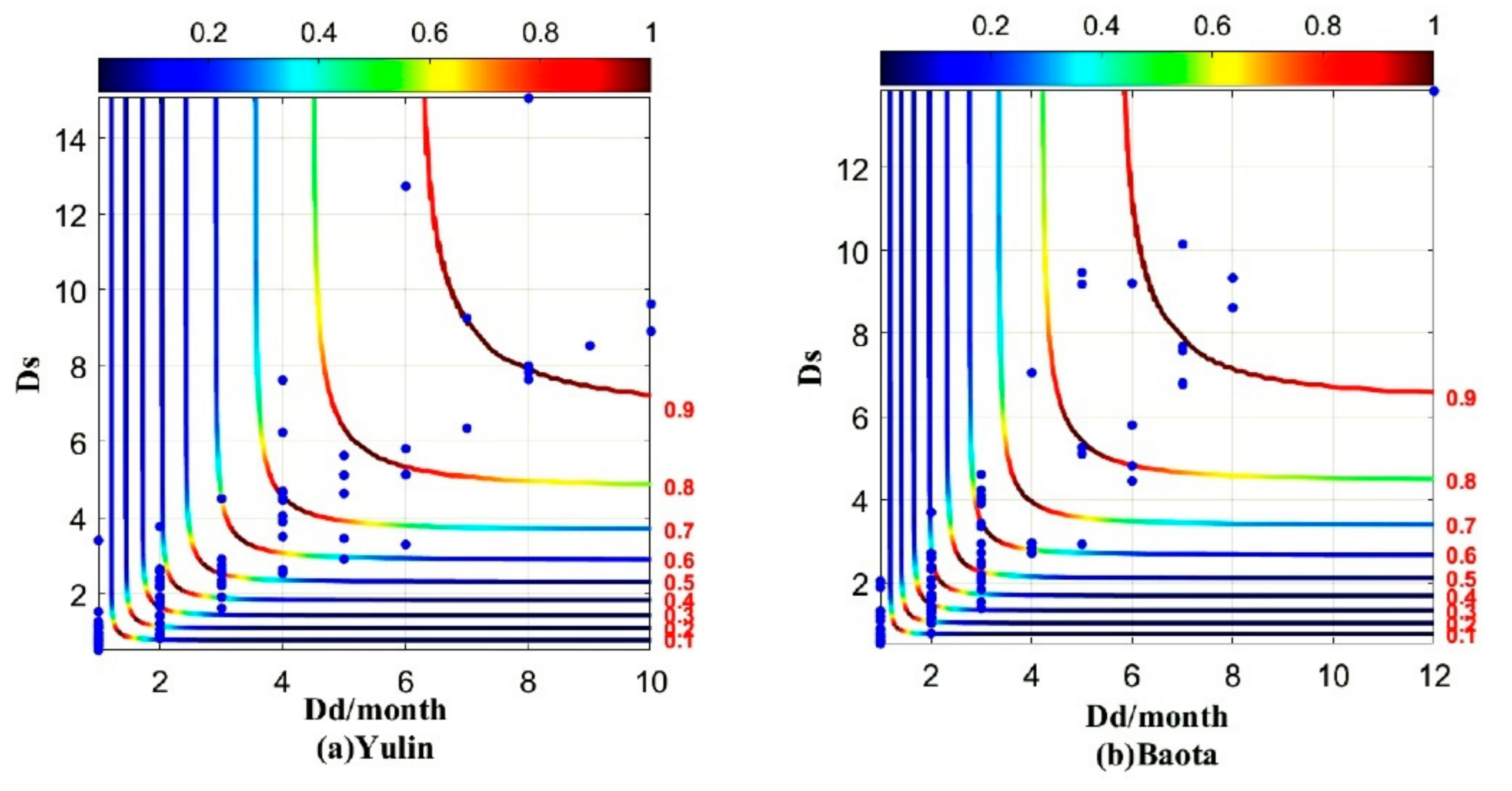
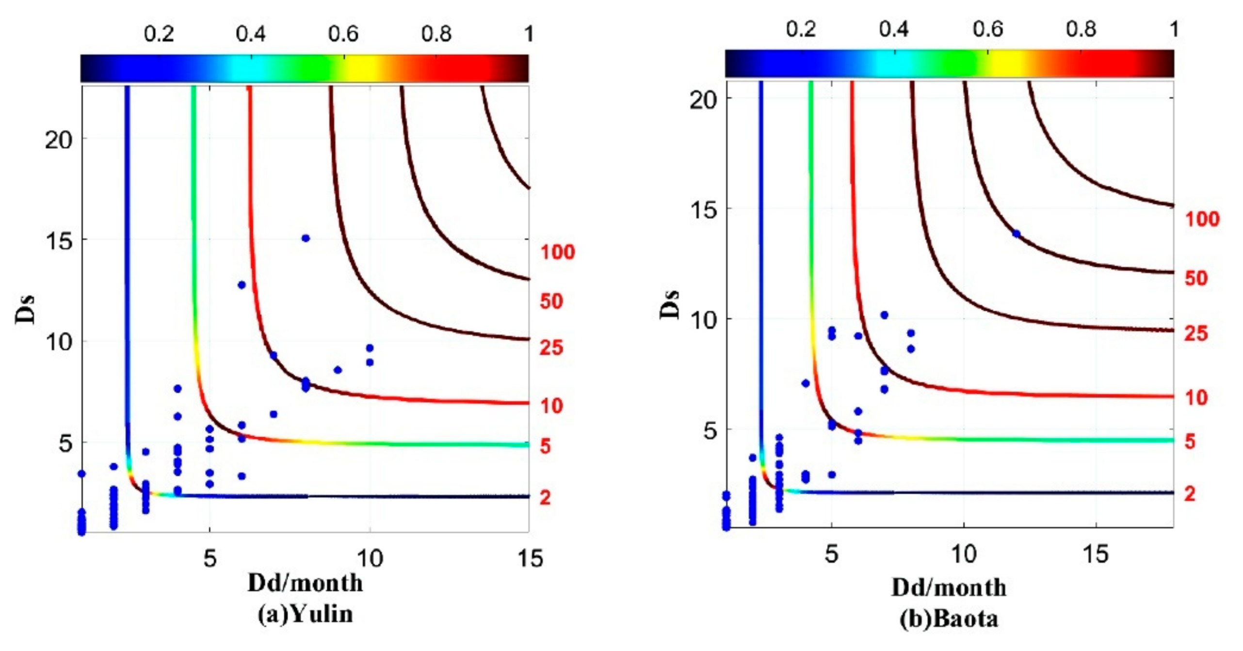
(2) The optimal edge distribution of drought duration and drought intensity in Northern Shaanxi is generalized Pareto distribution, and the optimal fitting function is Frank copula function. Finally, the combined probability and return interval of drought characteristic variables are obtained. When the drought duration is less than 4 months or the drought intensity is less than 4, the joint cumulative probability increases rapidly and the joint return period increases slowly with the increase of drought duration and intensity. When the duration of drought is more than 4 months or the intensity of drought is more than 4, the increasing trend of joint cumulative probability becomes slower and the increasing trend of joint return period becomes steeper.
(3) The model fitting results were compared with the actual crop affected area, and the actual eigenvalues of drought events were close to the theoretical eigenvalues. However, the actual return period and the error between the theoretical return period is only 0.1–0.3 a. The results of the joint return period can accurately reflect the actual situation, and this study can provide effective guidance for the prevention and management of agricultural dryland in Northern Shaanxi.


