
Simulation and Assessment of Future Glacial Lake Outburst Floods in the Poiqu River Basin, Central Himalayas


Abstract
1. Introduction
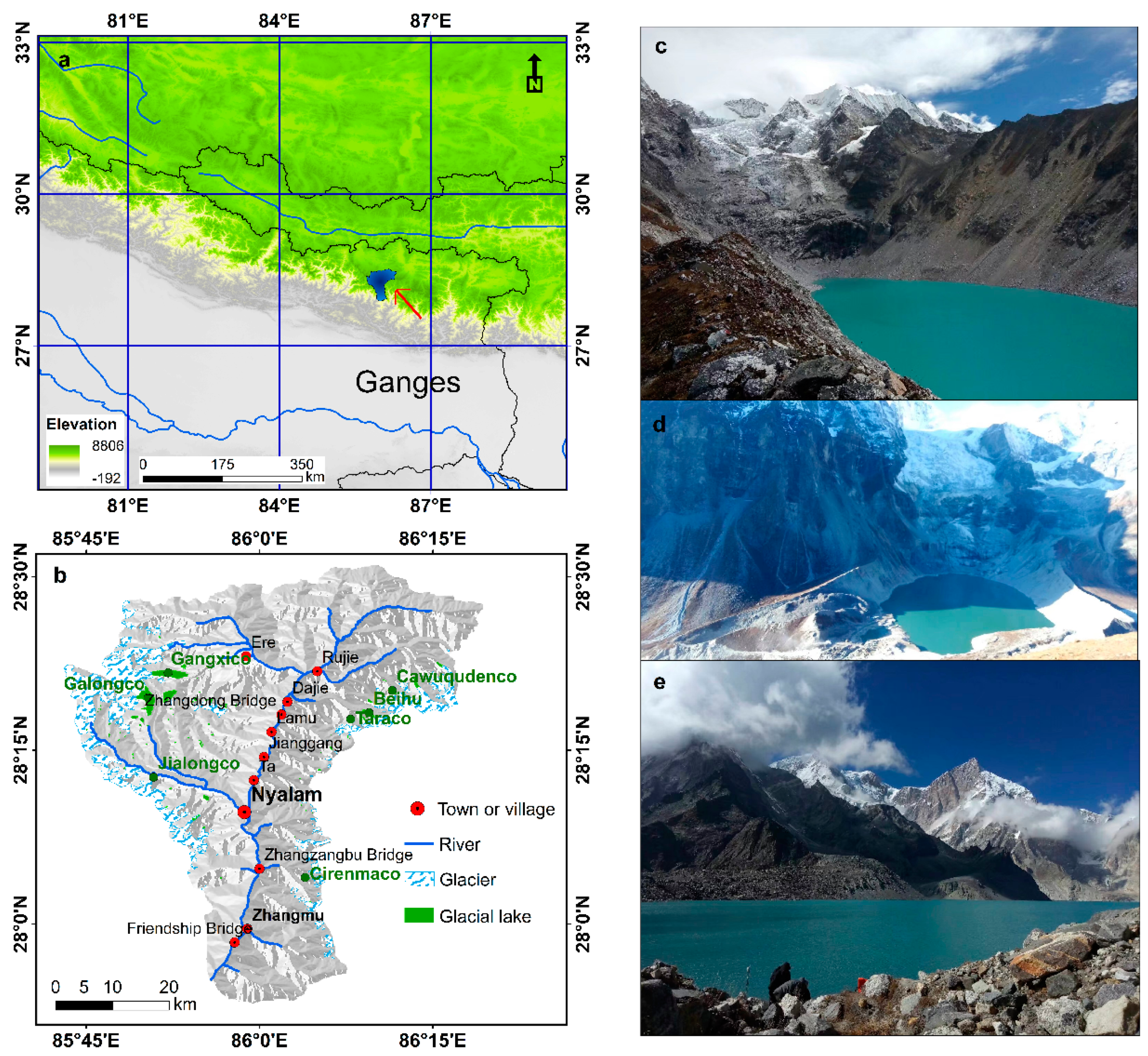
2. Study Area
2.1. Geographical and Climatic Setting
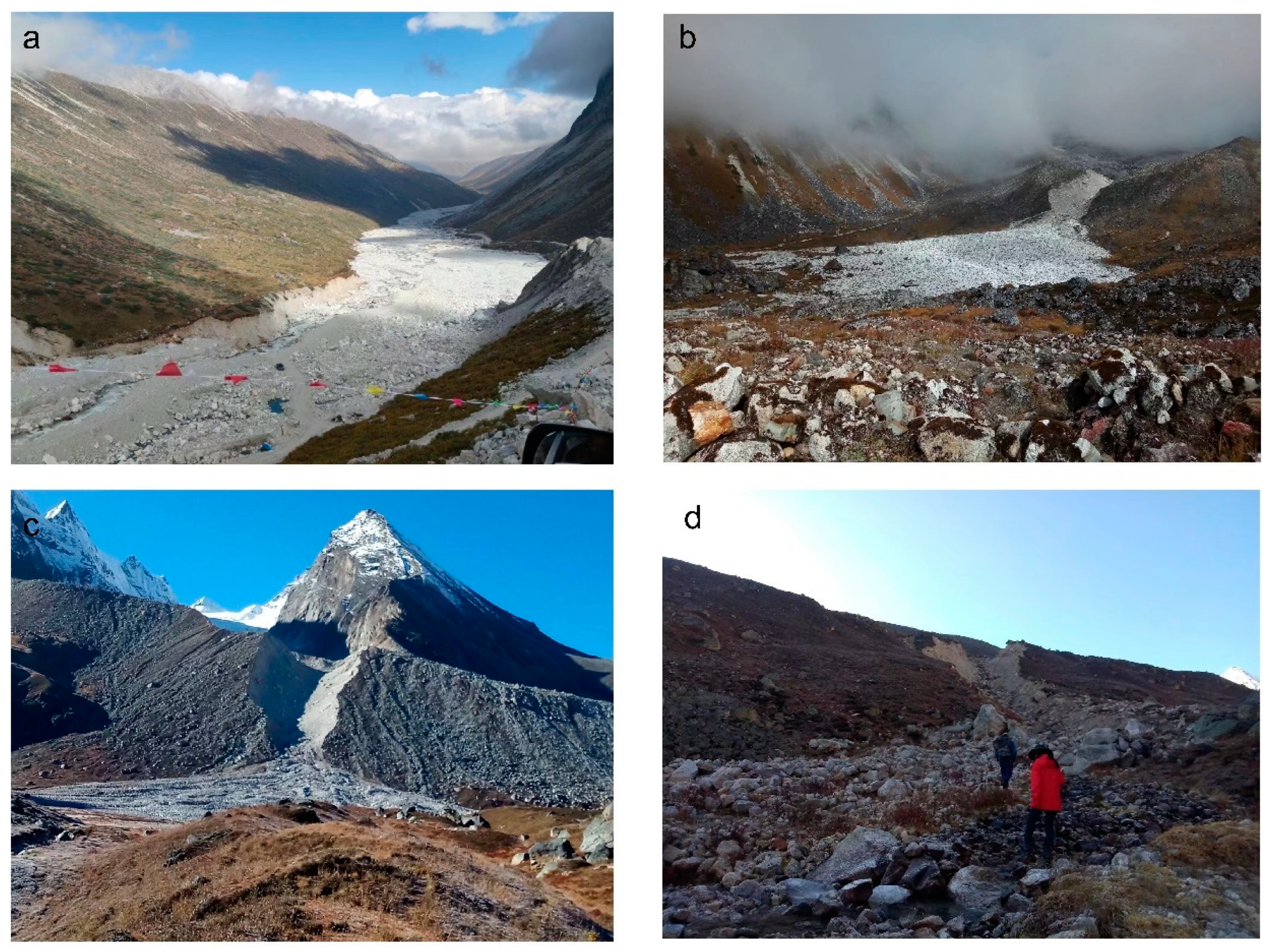
2.2. Historical GLOFs
3. Data and Methods
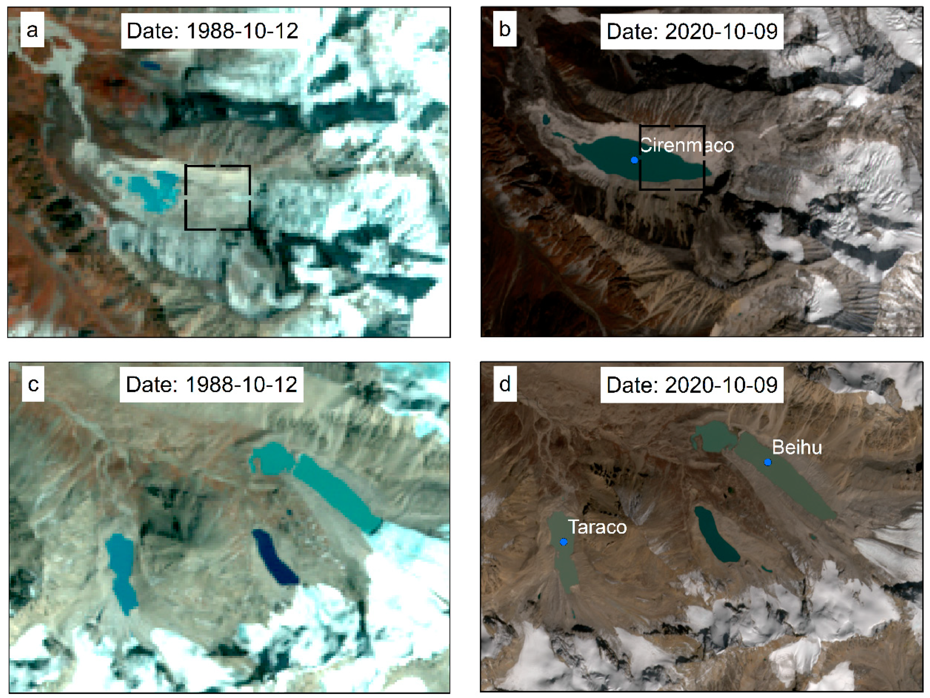
3.1. Remote Sensing Data
3.2. Potentially Dangerous Glacial Lakes
3.3. HEC-RAS Model and Parameters
3.3.1. Estimating Lake Volume, Peak Discharge, and Breaching Time
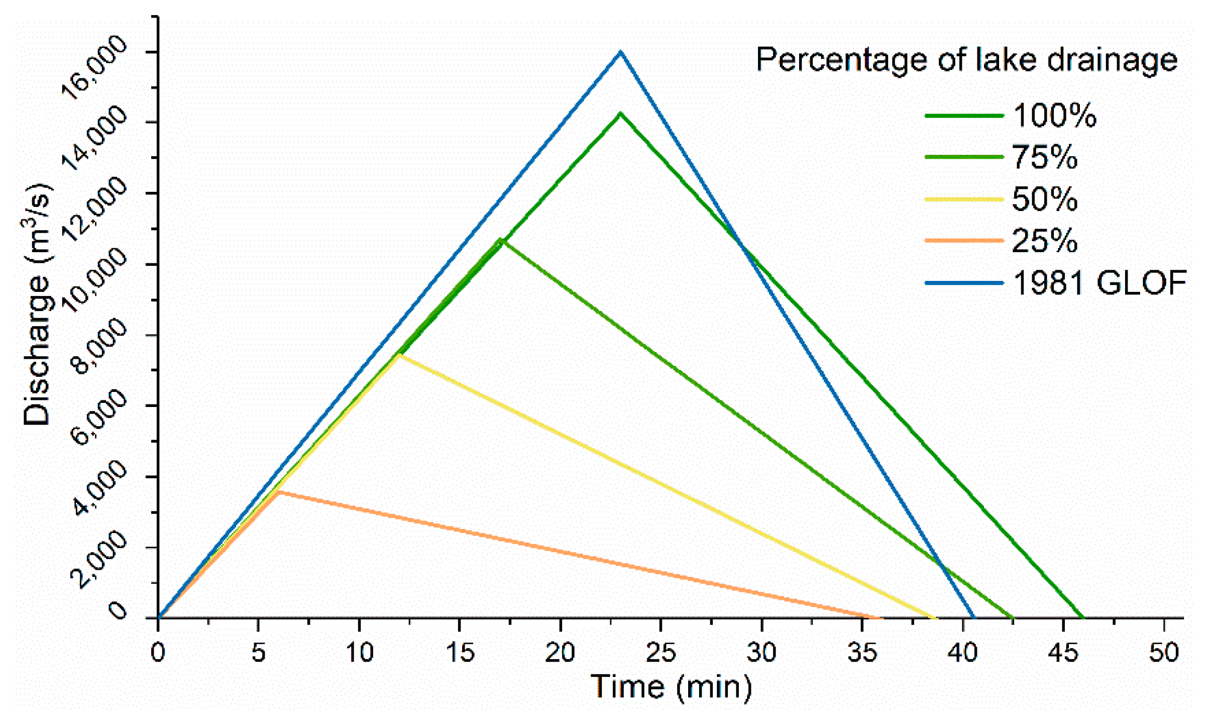
3.3.2. Dam-Breach Hydrograph
3.4. Hazard Index
4. Results
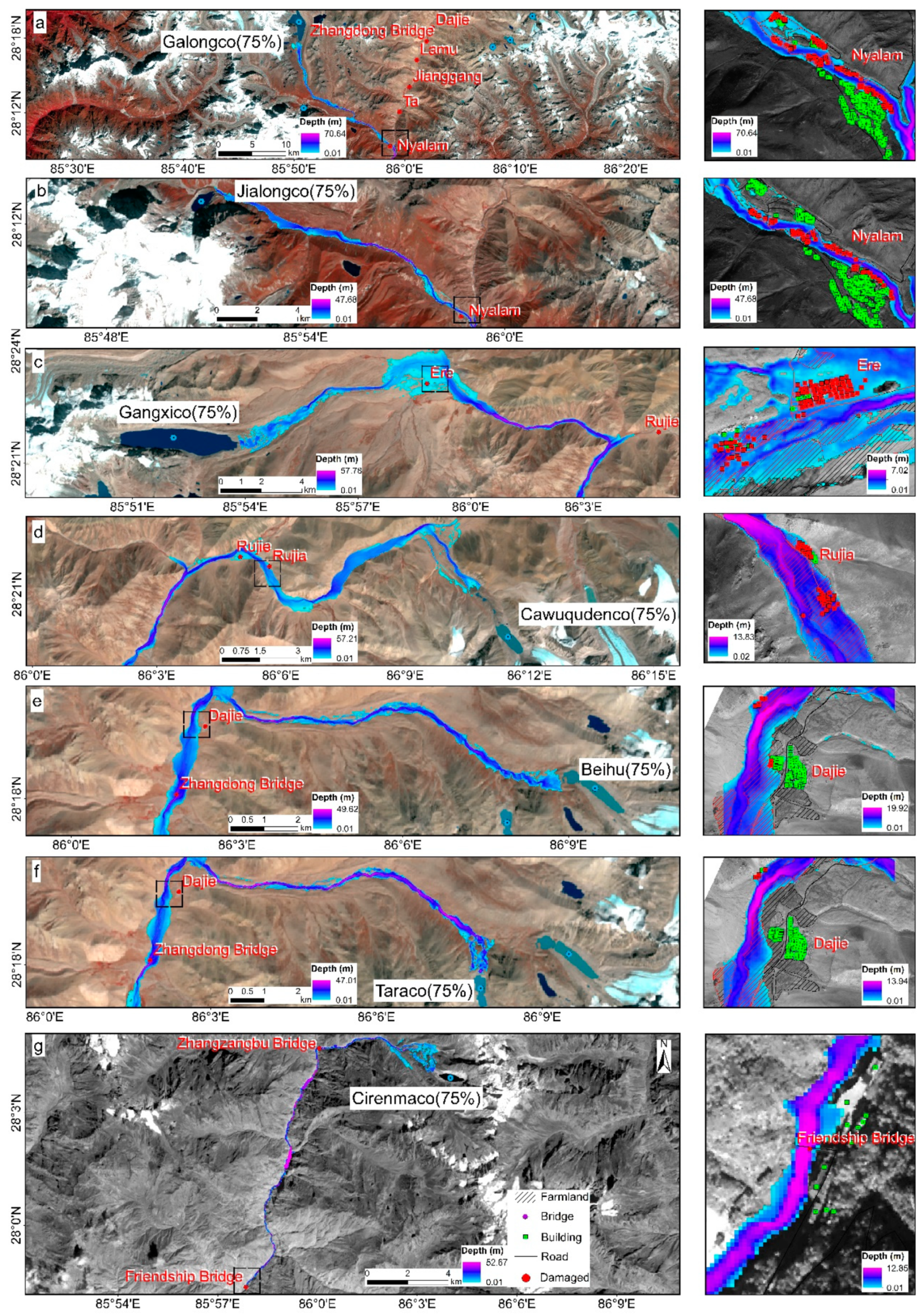
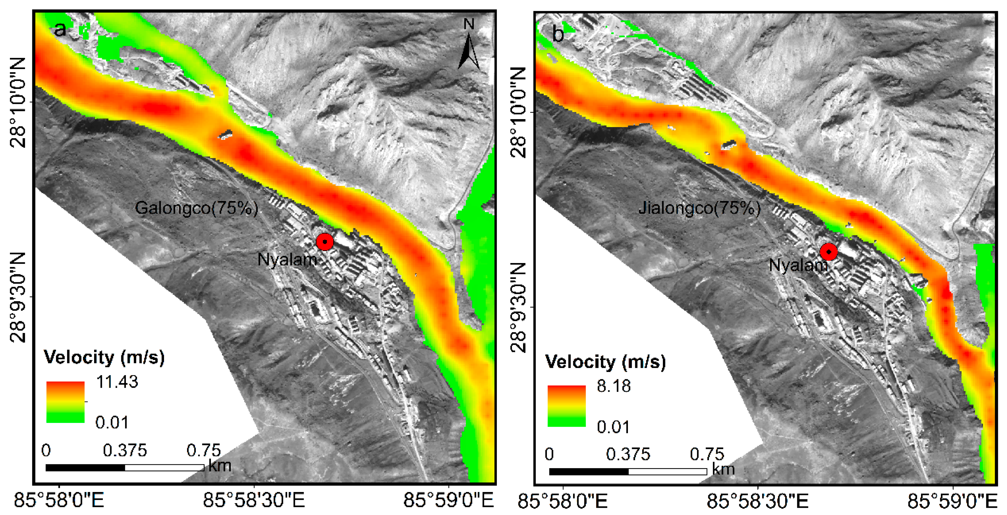
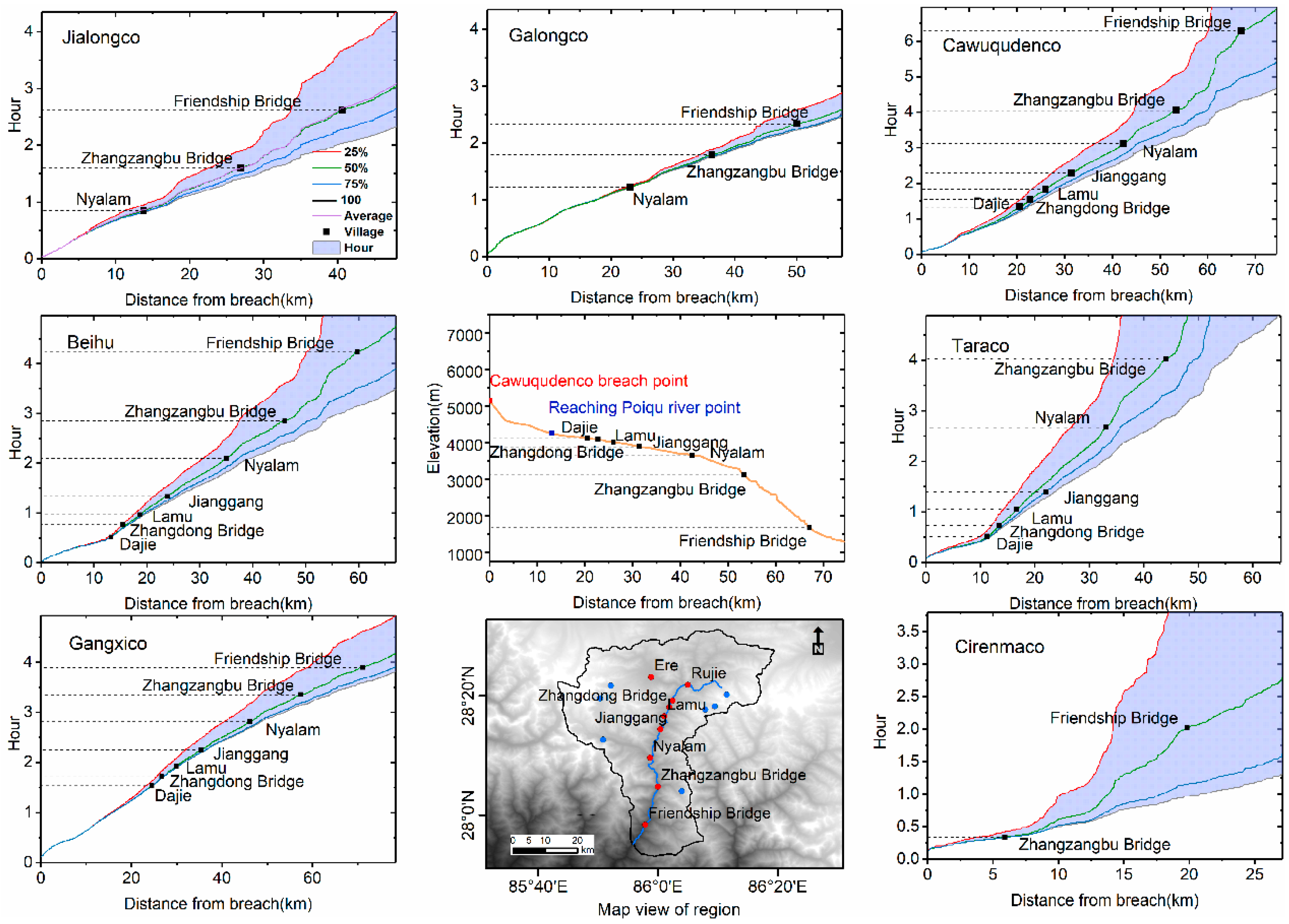
4.1. Impact of GLOFs
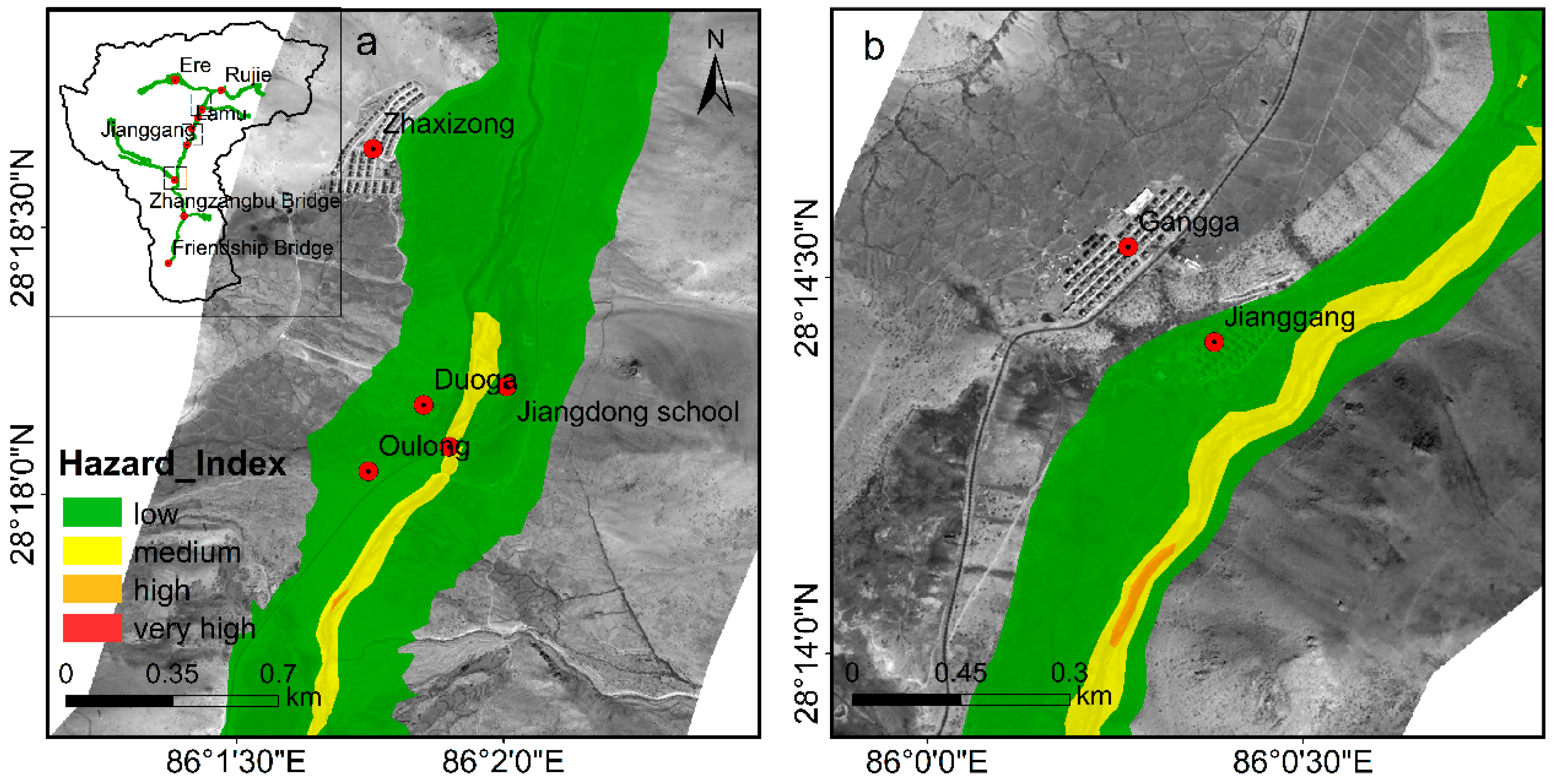
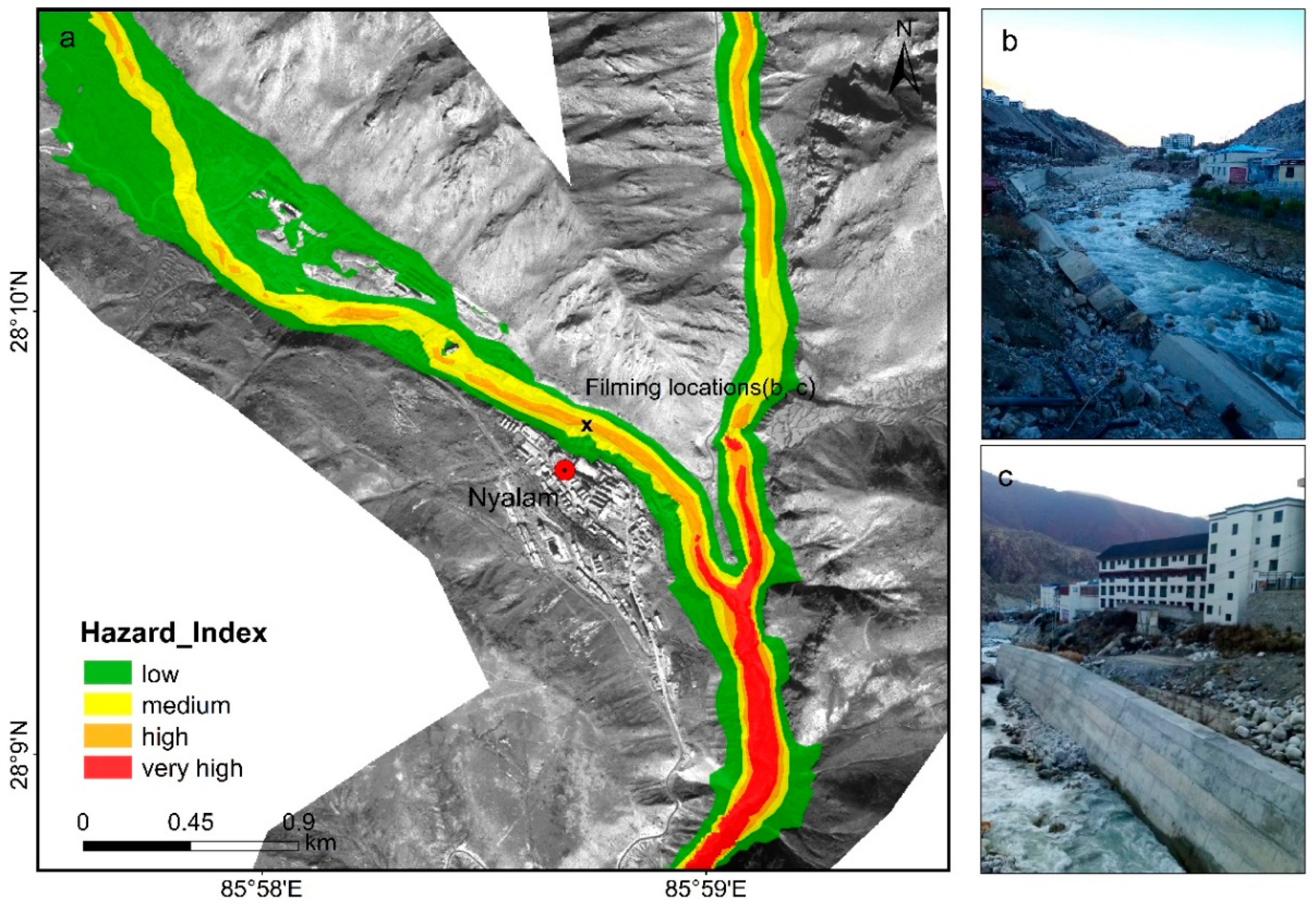
4.2. Hazard Map
5. Discussion
5.1. Uncertainty Analysis
5.1.1. Clear-Water Flow
5.1.2. Comparison with Other Studies
5.1.3. Modeling Parameters
5.2. Paradigm for Mapping Hazard/Risk
- Prepare the data and model. The HEC-RAS model is recommended due to its free availability (https://www.hec.usace.army.mil/software/hec-ras/, accessed on 15 October 2019), ease of operation, and extensive applications. Data from DEM is a critical component in flood simulation. When any other high-resolution DEM is not available, STRM can be used because of its better accuracy and wide range of applications. The data for infrastructure or farmland may be extracted from the most recent Landsat/Sentinel-2 images or from Google Earth.
- Estimate GLOF parameters. In the absence of in-situ measured data, lake volume and peak discharge may be determined by empirical or statistical methods. For example, a model-based Bayesian was presented by [65], which utilized robust linear regression to estimate parameters. A dam-breach hydrograph may be inferred using the same method as this study or may be simulated using a 1D breach model [33,36].
- Map hazard/risk. The flood depth and velocity datasets from the HEC-RAS model can be combined with the hazard/risk index and possible lake drainage scenarios to draw a synthesized map. These datasets can also be using to make a detailed assessment of exposure for downstream infrastructure, farmland, and population.
5.3. Lessons for GLOF Management
6. Conclusions
Author Contributions
Funding
Institutional Review Board Statement
Informed Consent Statement
Data Availability Statement
Acknowledgments
Conflicts of Interest
References
- Bolch, T.; Kulkarni, A.; Kaab, A.; Huggel, C.; Paul, F.; Cogley, J.G.; Frey, H.; Kargel, J.S.; Fujita, K.; Scheel, M.; et al. The state and fate of Himalayan glaciers. Science 2012, 336, 310–314. [Google Scholar] [CrossRef]
- Yao, T.; Thompson, L.; Yang, W.; Yu, W.; Gao, Y.; Guo, X.; Yang, X.; Duan, K.; Zhao, H.; Xu, B.; et al. Different glacier status with atmospheric circulations in Tibetan Plateau and surroundings. Nat. Clim. Chang. 2012, 2, 663–667. [Google Scholar] [CrossRef]
- Lutz, A.F.; Immerzeel, W.W.; Shrestha, A.B.; Bierkens, M.F.P. Consistent increase in High Asia’s runoff due to increasing glacier melt and precipitation. Nat. Clim. Chang. 2014, 4, 587–592. [Google Scholar] [CrossRef]
- Farinotti, D.; Longuevergne, L.; Moholdt, G.; Duethmann, D.; Mölg, T.; Bolch, T.; Vorogushyn, S.; Güntner, A. Substantial glacier mass loss in the Tien Shan over the past 50 years. Nat. Geosci. 2015, 8, 716–722. [Google Scholar] [CrossRef]
- Huss, M.; Hock, R. Global-scale hydrological response to future glacier mass loss. Nat. Clim. Chang. 2018, 8, 135–140. [Google Scholar] [CrossRef]
- Maurer, J.M.; Schaefer, J.M.; Rupper, S.; Corley, A. Acceleration of ice loss across the Himalayas over the last 40 years. Sci. Adv. 2019, 5, eaav7266. [Google Scholar] [CrossRef]
- Zhang, G.; Yao, T.; Xie, H.; Wang, W.; Yang, W. An inventory of glacial lakes in the Third Pole region and their changes in response to global warming. Glob. Planet. Chang. 2015, 131, 148–157. [Google Scholar] [CrossRef]
- Zheng, G.; Bao, A.; Li, J.; Zhang, G.; Xie, H.; Guo, H.; Jiang, L.; Chen, T.; Chang, C.; Chen, W. Sustained growth of high mountain lakes in the headwaters of the Syr Darya River, Central Asia. Glob. Planet. Chang. 2019, 176, 84–99. [Google Scholar] [CrossRef]
- Wang, X.; Guo, X.; Yang, C.; Liu, Q.; Wei, J.; Zhang, Y.; Liu, S.; Zhang, Y.; Jiang, Z.; Tang, Z. Glacial lake inventory of high-mountain Asia in 1990 and 2018 derived from Landsat images. Earth Syst. Sci. Data 2020, 12, 2169–2182. [Google Scholar] [CrossRef]
- Nie, Y.; Sheng, Y.; Liu, Q.; Liu, L.; Liu, S.; Zhang, Y.; Song, C. A regional-scale assessment of Himalayan glacial lake changes using satellite observations from 1990 to 2015. Remote. Sens. Environ. 2017, 189, 1–13. [Google Scholar] [CrossRef]
- Richardson, S.D.; Reynolds, J.M. An overview of glacial hazards in the Himalayas. Quat. Int. 2000, 65, 31–47. [Google Scholar] [CrossRef]
- Kuriqi, A.; Ali, R.; Pham, Q.B.; Gambini, J.M.; Gupta, V.; Malik, A.; Linh, N.T.T.; Joshi, Y.; Anh, D.T.; Nam, V.T.; et al. Seasonality shift and streamflow flow variability trends in central India. Acta. Geophys. 2020, 68, 1461–1475. [Google Scholar] [CrossRef]
- Islam, A.R.M.T.; Talukdar, S.; Mahato, S.; Kundu, S.; Eibek, K.U.; Pham, Q.B.; Kuriqi, A.; Linh, N.T.T. Flood susceptibility modelling using advanced ensemble machine learning models. Geosci. Front. 2021, 12, 101075. [Google Scholar] [CrossRef]
- Komori, J.; Koike, T.; Yamanokuchi, T.; Tshering, P. Glacial lake outburst events in the Bhutan Himalayas. Glob. Environ. Res. 2012, 16, 59–70. [Google Scholar]
- Nie, Y.; Liu, Q.; Wang, J.; Zhang, Y.; Sheng, Y.; Liu, S. An inventory of historical glacial lake outburst floods in the Himalayas based on remote sensing observations and geomorphological analysis. Geomorphology 2018, 308, 91–106. [Google Scholar] [CrossRef]
- Zheng, G.; Bao, A.; Allen, S.; Antonio Ballesteros-Cánovas, J.; Yuan, Y.; Jiapaer, G.; Stoffel, M. Numerous unreported glacial lake outburst floods in the Third Pole revealed by high-resolution satellite data and geomorphological evidence. Sci. Bull. 2021. [Google Scholar] [CrossRef]
- Emmer, A.; Cochachin, A. The causes and mechanisms of moraine-dammed lake failures in the Cordillera Blanca, North American Cordillera and Himalaya. AUC Geogr. 2013, 48, 5–15. [Google Scholar] [CrossRef]
- Carrivick, J.L.; Tweed, F.S. A global assessment of the societal impacts of glacier outburst floods. Glob. Planet. Chang. 2016, 144, 1–16. [Google Scholar] [CrossRef]
- Allen, S.K.; Rastner, P.; Arora, M.; Huggel, C.; Stoffel, M. Lake outburst and debris flow disaster at Kedarnath, June 2013: Hydrometeorological triggering and topographic predisposition. Landslides 2015, 13, 1479–1491. [Google Scholar] [CrossRef]
- Rafiq, M.; Romshoo, S.A.; Mishra, A.K.; Jalal, F. Modelling Chorabari Lake outburst flood, Kedarnath, India. J. Mt. Sci. 2019, 16, 64–76. [Google Scholar] [CrossRef]
- Zhang, G.; Bolch, T.; Allen, S.; Linsbauer, A.; Chen, W.; Wang, W. Glacial lake evolution and glacier–lake interactions in the Poiqu River basin, central Himalaya, 1964–2017. J. Glaciol. 2019, 65, 347–365. [Google Scholar] [CrossRef]
- Wang, W.; Yao, T.; Gao, Y.; Yang, X.; Kattel, D.B. A First-order Method to Identify Potentially Dangerous Glacial Lakes in a Region of the Southeastern Tibetan Plateau. Mt. Res. Dev. 2011, 31, 122. [Google Scholar] [CrossRef]
- Worni, R.; Huggel, C.; Stoffel, M. Glacial lakes in the Indian Himalayas--from an area-wide glacial lake inventory to on-site and modeling based risk assessment of critical glacial lakes. Sci. Total. Environ. 2013, 468–469, S71–S84. [Google Scholar] [CrossRef]
- Aggarwal, S.; Rai, S.C.; Thakur, P.K.; Emmer, A. Inventory and recently increasing GLOF susceptibility of glacial lakes in Sikkim, Eastern Himalaya. Geomorphology 2017, 295, 39–54. [Google Scholar] [CrossRef]
- Wang, S.; Qin, D.; Xiao, C. Moraine-dammed lake distribution and outburst flood risk in the Chinese Himalaya. J. Glaciol. 2017, 61, 115–126. [Google Scholar]
- Allen, S.K.; Zhang, G.; Wang, W.; Yao, T.; Bolch, T. Potentially dangerous glacial lakes across the Tibetan Plateau revealed using a large-scale automated assessment approach. Sci. Bull. 2019, 64, 435–445. [Google Scholar] [CrossRef]
- Fan, J.; An, C.; Zhang, X.; Li, X.; Tan, J. Hazard assessment of glacial lake outburst floods in Southeast Tibet based on RS and GIS technologies. Int. J. Remote. Sens. 2019, 40, 4955–4979. [Google Scholar] [CrossRef]
- Dubey, S.; Goyal, M.K. Glacial Lake Outburst Flood Hazard, Downstream Impact, and Risk Over the Indian Himalayas. Water Resour. Res. 2020, 56. [Google Scholar] [CrossRef]
- Wang, S.; Che, Y.; Xinggang, M. Integrated risk assessment of glacier lake outburst flood (GLOF) disaster over the Qinghai–Tibetan Plateau (QTP). Landslides 2020, 17, 2849–2863. [Google Scholar] [CrossRef]
- Lala, J.M.; Rounce, D.R.; McKinney, D.C. Modeling the glacial lake outburst flood process chain in the Nepal Himalaya: Reassessing Imja Tsho's hazard. Hydrol. Earth Syst. Sci. 2018, 22, 3721–3737. [Google Scholar] [CrossRef]
- Wang, W.; Gao, Y.; Anacona, P.I.; Lei, Y.; Xiang, Y.; Zhang, G.; Li, S.; Lu, A. Integrated hazard assessment of Cirenmaco glacial lake in Zhangzangbo valley, Central Himalayas. Geomorphology 2018, 306, 292–305. [Google Scholar] [CrossRef]
- Byers, A.C.; Chand, M.B.; Lala, J.; Shrestha, M.; Byers, E.A.; Watanabe, T. Reconstructing the History of Glacial Lake Outburst Floods (GLOF) in the Kanchenjunga Conservation Area, East Nepal: An Interdisciplinary Approach. Sustainability 2020, 12, 5407. [Google Scholar] [CrossRef]
- Nie, Y.; Liu, W.; Liu, Q.; Hu, X.; Westoby, M.J. Reconstructing the Chongbaxia Tsho glacial lake outburst flood in the Eastern Himalaya: Evolution, process and impacts. Geomorphology 2020, 370, 107393. [Google Scholar] [CrossRef]
- Maurer, J.M.; Schaefer, J.M.; Russell, J.B.; Rupper, S.; Wangdi, N.; Putnam, A.E.; Young, N. Seismic observations, numerical modeling, and geomorphic analysis of a glaical lake outburst flood in the Himalayas. Sci. Adv. 2020, 6, eaba3645. [Google Scholar] [CrossRef] [PubMed]
- Majeed, U.; Rashid, I.; Sattar, A.; Allen, S.; Stoffel, M.; Nusser, M.; Schmidt, S. Recession of Gya Glacier and the 2014 glacial lake outburst flood in the Trans-Himalayan region of Ladakh, India. Sci. Total Environ. 2021, 756, 144008. [Google Scholar] [CrossRef] [PubMed]
- Khanal, N.R.; Hu, J.; Mool, P. Glacial Lake Outburst Flood Risk in the Poiqu/Bhote Koshi/Sun Koshi River Basin in the Central Himalayas. Mt. Res. Dev. 2015, 35, 351–364. [Google Scholar] [CrossRef]
- Allen, S.K.; Linsbauer, A.; Randhawa, S.S.; Huggel, C.; Rana, P.; Kumari, A. Glacial lake outburst flood risk in Himachal Pradesh, India: An integrative and anticipatory approach considering current and future threats. Nat. Hazards 2016, 84, 1741–1763. [Google Scholar] [CrossRef]
- Rounce, D.R.; McKinney, D.C.; Lala, J.M.; Byers, A.C.; Watson, C.S. A new remote hazard and risk assessment framework for glacial lakes in the Nepal Himalaya. Hydrol. Earth Syst. Sci. 2016, 20, 3455–3475. [Google Scholar] [CrossRef]
- Chen, X.; Cui, P.; Li, Y.; Yang, Z.; Qi, Y. Changes in glacial lakes and glaciers of post-1986 in the Poiqu River basin, Nyalam, Xizang (Tibet). Geomorphology 2007, 88, 298–311. [Google Scholar] [CrossRef]
- Shrestha, A.B.; Eriksson, M.; Mool, P.; Ghimire, P.; Mishra, B.; Khanal, N.R. Glacial lake outburst flood risk assessment of Sun Koshi basin, Nepal. Geomat. Nat. Hazards Risk 2010, 1, 157–169. [Google Scholar] [CrossRef]
- Liu, M.; Chen, N.; Zhang, Y.; Deng, M. Glacial lake inventory and lake outburst flood/debris flow hazard assessment after the Gorkha earthquake in the Bhote Koshi Basin. Water 2020, 12, 464. [Google Scholar] [CrossRef]
- Xu, D. Characteristics of debris flow caused by outburst of glacial lake in Boqu river, Xizang, China, 1981. GeoJournal 1988, 17, 569–580. [Google Scholar] [CrossRef]
- Chen, N.; Hu, G.; Deng, W.; Khanal, N.; Zhu, Y.; Han, D. On the water hazards in the trans-boundary Kosi River basin. Nat. Hazards Earth Syst. Sci. 2013, 13, 795–808. [Google Scholar] [CrossRef]
- Chen, X.; Cui, P.; Yang, Z.; Qi, Y. Debris flows of Chongdui gully in Nyalam County, 2002: Cause and Control. J. Glaciol. Geocryol. 2006, 28, 776–781. (In Chinese) [Google Scholar]
- Cook, K.L.; Andermann, C.; Gimbert, F.; Adhikari, B.R.; Hovius, N. Glacial lake outburst floods as drivers of fluvial erosion in the Himalaya. Science 2018, 362, 53–57. [Google Scholar] [CrossRef]
- Veh, G.; Korup, O.; von Specht, S.; Roessner, S.; Walz, A. Unchanged frequency of moraine-dammed glacial lake outburst floods in the Himalaya. Nat. Clim. Chang. 2019, 9, 379–383. [Google Scholar] [CrossRef]
- Shean, D. High Mountain Asia 8-Meter DEMs Derived from Along-Track Optical Imagery; Version 1, [Indicate subset used]; NASA National Snow and Ice Data Center Distributed Active Archive Center: Boulder, CO, USA, 2017. [Google Scholar]
- Cenderelli, D.A.; Wohl, E.E. Peak discharge estimates of glacial-lake outburst floods and “normal” climatic floods in the Mount Everest region, Nepal. Geomorphology 2001, 40, 57–90. [Google Scholar] [CrossRef]
- Alho, P.; Russell, A.J.; Carrivick, J.L.; Käyhkö, J. Reconstruction of the largest Holocene jökulhlaup within Jökulsá á Fjöllum, NE Iceland. Quat. Sci. Rev. 2005, 24, 2319–2334. [Google Scholar] [CrossRef]
- Alho, P.; Aaltonen, J. Comparing a 1D hydraulic model with a 2D hydraulic model for the simulation of extreme glacial outburst floods. Hydrol. Process. 2008, 22, 1537–1547. [Google Scholar] [CrossRef]
- Osti, R.; Egashira, S. Hydrodynamic characteristics of the Tam Pokhari Glacial Lake outburst flood in the Mt. Everest region, Nepal. Hydrol. Process. 2009, 23, 2943–2955. [Google Scholar] [CrossRef]
- Anacona, P.I.; Mackintosh, A.; Norton, K. Reconstruction of a glacial lake outburst flood (GLOF) in the Engaño Valley, Chilean Patagonia: Lessons for GLOF risk management. Sci. Total Environ. 2015, 527, 1–11. [Google Scholar] [CrossRef] [PubMed]
- Kougkoulos, I.; Cook, S.J.; Edwards, L.A.; Clarke, L.J.; Symeonakis, E.; Dortch, J.M.; Nesbitt, K. Modelling glacial lake outburst flood impacts in the Bolivian Andes. Nat. Hazards 2018, 94, 1415–1438. [Google Scholar] [CrossRef]
- Cook, S.J.; Quincey, D.J. Estimating the volume of Alpine glacial lakes. Earth Surf. Dyn. 2015, 3, 559–575. [Google Scholar] [CrossRef]
- Froehlich, D.C. Peak outflow from breached embankment dam. J. Water Resour. Plan. Man. 1995, 121, 90–97. [Google Scholar] [CrossRef]
- Froehlich, D.C. Embankment dam breach parameters revisited. In Proceeding of The Conference on Water Resources Engineering, San Antonio, TX, USA, 14–18 August 1995; pp. 887–891. [Google Scholar]
- Wahl, T.L. Uncertainty of predictions of embankment dam breach parameters. J. Hydraul. Eng. 2004, 130, 389–397. [Google Scholar] [CrossRef]
- Worni, R.; Stoffel, M.; Huggel, C.; Volz, C.; Casteller, A.; Luckman, B. Analysis and dynamic modeling of a moraine failure and glacier lake outburst flood at Ventisquero Negro, Patagonian Andes (Argentina). J. Hydrol. 2012, 444, 134–145. [Google Scholar] [CrossRef]
- Westoby, M.J.; Glasser, N.F.; Brasington, J.; Hambrey, M.J.; Quincey, D.J.; Reynolds, J.M. Modelling outburst floods from moraine-dammed glacial lakes. Earth Sci. Rev. 2014, 134, 137–159. [Google Scholar] [CrossRef]
- Huggel, C.; Haeberli, W.; Kääb, A.; Bieri, D.; Richardson, S. An assessment procedure for glacial hazards in the Swiss Alps. Can. Geotech. J. 2004, 41, 1068–1083. [Google Scholar] [CrossRef]
- Huggel, C.; Kääb, A.; Haeberli, W.; Teysseire, P. Remote sensing based assessment of hazards from glacier lake outbursts: A case study in the Swiss Alps. Can. Geotech. J. 2002, 330, 316–330. [Google Scholar] [CrossRef]
- Fujita, K.; Sakai, A.; Takenaka, S.; Nuimura, T.; Surazakov, A.B.; Sawagaki, T.; Yamanokuchi, T. Potential flood volume of Himalayan glacial lakes. Nat. Hazards Earth Syst. Sci. 2013, 13, 1827–1839. [Google Scholar] [CrossRef]
- Patel, L.K.; Sharma, P.; Laluraj, C.M.; Thamban, M.; Singh, A.; Ravindra, R. A geospatial analysis of Samudra Tapu and Gepang Gath glacial lakes in the Chandra Basin. Western Himalaya. Nat. Hazards 2017, 86, 1275–1290. [Google Scholar] [CrossRef]
- Kougkoulos, I.; Cook, S.J.; Jomelli, V.; Clarke, L.; Symeonakis, E.; Dortch, J.M.; Edwards, L.A.; Merad, M. Use of multi-criteria decision analysis to identify potentially dangerous glacial lakes. Sci. Total Environ. 2018, 621, 1453–1466. [Google Scholar] [CrossRef] [PubMed]
- Veh, G.; Korup, O.; Walz, A. Hazard from Himalayan glacier lake outburst floods. Proc. Natl. Acad. Sci. USA 2020, 117, 907–912. [Google Scholar] [CrossRef] [PubMed]


| Lake | Long ° | Lat ° | Area (km2) | Elevation (m) | Lake Area Change (km2/10a) | Risk Index [26] |
|---|---|---|---|---|---|---|
| Gangxico | 85.87 | 28.36 | 4.57 | 5212 | 0.73 | 0.8 |
| Galongco | 85.31 | 28.84 | 5.38 | 5067 | 1.08 | 0.94 |
| Jialongco | 85.21 | 28.84 | 0.60 | 4360 | 0.12 | 0.87 |
| Cirenmaco | 86.06 | 28.06 | 0.29 | 4627 | 0.08 | 0.95 |
| Taraco | 86.13 | 28.29 | 0.23 | 5244 | 0.01 | 0.72 |
| Beihu | 86.15 | 28.30 | 0.56 | 5307 | 0.04 | 0.79 |
| Cawuqudenco | 86.19 | 28.33 | 0.53 | 5422 | 0.02 | 0.73 |
| Glacial Lake | V(106 m3) | hb (m) | hw (m) | Tp (min) | Qp (104 m3/s) |
|---|---|---|---|---|---|
| Gangxico | 267.97 | 89 | 67 | 79 | 3.42 |
| Galongco | 316.52 | 95 | 80 | 81 | 4.47 |
| Jialongco | 29.72 | 74 | 62 | 29 | 1.62 |
| Cirenmaco | 18 | 72 | 63 | 23 | 1.43 |
| Taraco | 7.23 | 83 | 77 | 12 | 1.40 |
| Beihu | 27.04 | 87 | 76 | 24 | 2.03 |
| Cawuqudenco | 25.58 | 80 | 63 | 25 | 1.58 |
| ID | Lake | Outburst Date | Country | Long ° | Lat ° | Date of Last Clear Image before GLOF | Date of Last Clear Image after GLOF | Area before (106 m2) | Volume before (106 m3) | Volume after (106 m3) | Volume Change (%) |
|---|---|---|---|---|---|---|---|---|---|---|---|
| 1 | Tam Pokhari | 3 September 1998 | Nepal | 86.84 | 27.74 | 1998-02-19 | 1998-10-17 | 0.58 | 10.03 | 4.59 | 54% |
| 2 | Chongbaxiaco | 6 August 2000 | China | 89.74 | 28.21 | 2001-07-23 | 2003-11-18 | 0.77 | 18.23 | 9.49 | 48% |
| 3 | Zangla Tsho | 1994 | China | 82.14 | 30.34 | 1994-07-30 | 1994-09-09 | 0.23 | 6.61 | 2.21 | 67% |
| 4 | Rejieco | 1992 | China | 88.89 | 27.97 | 1992-04-16 | 1992-11-10 | 0.27 | 8.76 | 4.18 | 52% |
| 5 | Zanglaco East | 2015–2016 | China | 82.20 | 30.31 | 2015-09-05 | 2016-05-16 | 0.30 | 4.98 | 2.79 | 44% |
| 6 | Sangwangco East | 2007–2008 | China | 90.23 | 28.28 | 2007-07-08 | 2008-12-17 | 1.04 | 28.76 | 23.05 | 20% |
| 7 | Changri Tsho III | 1998 | Bhutan | 90.81 | 27.90 | 1997-11-01 | 1998-09-10 | 0.49 | 0.64 | 0.11 | 83% |
| 8 | Kongyangmi La Tsho | 1994–1996 | India | 88.78 | 27.90 | 1994-10-31 | 1996-05-13 | 0.50 | 11.16 | 2.86 | 74% |
| 9 | Luggye Tsho | 7 October 1994 | Bhutan | 90.30 | 28.09 | 1994-09-22 | 1994-11-09 | 1.22 | 32.21 | 24.11 | 25% |
| Glacial Lake | Breach Water Volume (%) | Trans-Boundary Impact | Flooded Area (km2) | Mean Depth (m) | Max Depth (m) | Mean Velocity (m/s) | Max Velocity (m/s) | Farmland (km2) | Roads (km) | Buildings | Bridges |
|---|---|---|---|---|---|---|---|---|---|---|---|
| Gangxico | 25 | Yes | 14.77 | 7.78 | 44.70 | 3.28 | 22.09 | 1.72 | 25.96 | 284 | 17 |
| 50 | Yes | 18.71 | 10.90 | 52.62 | 4.05 | 26.39 | 2.41 | 34.58 | 440 | 18 | |
| 75 | Yes | 21.40 | 13.21 | 57.78 | 4.56 | 28.45 | 2.76 | 40.55 | 507 | 18 | |
| 100 | Yes | 23.32 | 15.06 | 63.93 | 4.93 | 29.93 | 3.00 | 44.66 | 539 | 18 | |
| Galongco | 25 | Yes | 8.76 | 10.26 | 47.87 | 4.45 | 23.71 | - | 8.93 | 79 | 10 |
| 50 | Yes | 10.59 | 14.31 | 62.25 | 5.42 | 27.81 | - | 11.20 | 111 | 10 | |
| 75 | Yes | 11.92 | 17.48 | 70.64 | 6.04 | 30.11 | - | 12.02 | 132 | 10 | |
| 100 | Yes | 13.20 | 19.14 | 76.67 | 6.30 | 29.46 | - | 12.51 | 140 | 10 | |
| Jialongco | 25 | Yes | 4.09 | 6.27 | 37.04 | 2.98 | 11.02 | - | 3.67 | 34 | 10 |
| 50 | Yes | 5.03 | 9.05 | 44.57 | 3.87 | 14.73 | - | 7.53 | 67 | 10 | |
| 75 | Yes | 5.61 | 10.91 | 47.68 | 4.41 | 16.55 | - | 9.38 | 75 | 10 | |
| 100 | Yes | 6.36 | 13.33 | 58.92 | 5.05 | 19.18 | - | 10.99 | 104 | 10 | |
| Cirenmaco | 25 | Yes | 1.79 | 5.96 | 42.26 | 3.70 | 12.63 | - | 0.03 | 2 | |
| 50 | Yes | 2.23 | 8.75 | 47.94 | 5.24 | 18.14 | - | 0.04 | 2 | ||
| 75 | Yes | 2.48 | 10.84 | 52.46 | 6.08 | 19.61 | - | 0.06 | 2 | ||
| 100 | Yes | 2.71 | 12.85 | 56.73 | 6.73 | 22.32 | - | 0.05 | 2 | ||
| Taraco | 25 | No | 3.64 | 2.85 | 11.68 | 2.29 | 8.93 | 0.27 | 1.57 | 3 | 7 |
| 50 | No | 5.59 | 4.46 | 27.58 | 2.91 | 10.65 | 0.56 | 4.01 | 11 | 11 | |
| 75 | No | 7.02 | 5.82 | 47.01 | 3.33 | 11.77 | 0.83 | 5.89 | 37 | 12 | |
| 100 | Yes | 8.54 | 7.51 | 49.98 | 3.82 | 13.28 | 1.10 | 8.69 | 85 | 13 | |
| Beihu | 25 | No | 6.33 | 5.13 | 42.21 | 2.87 | 12.26 | 0.73 | 5.26 | 22 | 12 |
| 50 | Yes | 8.54 | 7.74 | 45.64 | 3.66 | 15.24 | 1.15 | 9.37 | 90 | 13 | |
| 75 | Yes | 10.04 | 9.55 | 49.63 | 4.18 | 17.31 | 1.51 | 12.56 | 195 | 13 | |
| 100 | Yes | 11.20 | 11.12 | 53.04 | 4.62 | 18.96 | 1.70 | 15.40 | 268 | 13 | |
| Cawuqudenco | 25 | No | 8.24 | 4.40 | 49.26 | 2.46 | 9.20 | 0.81 | 8.25 | 45 | 17 |
| 50 | Yes | 10.48 | 6.31 | 54.94 | 3.06 | 11.99 | 1.15 | 13.26 | 109 | 18 | |
| 75 | Yes | 12.04 | 7.75 | 57.21 | 3.51 | 13.68 | 1.47 | 18.16 | 175 | 18 | |
| 100 | Yes | 13.01 | 9.04 | 59.30 | 3.87 | 15.95 | 1.86 | 21.98 | 322 | 18 |
| Glacial Lake | Breach Water Volume (%) | Ere | Rujie | Dajie | Zhangdong Bridge | Jiangdong | Lamu | Zhaxigang | Jianggang | Ta | Nyalam | Friendship Bridge |
|---|---|---|---|---|---|---|---|---|---|---|---|---|
| Gangxico | 25 | 0.47 | 0.02 | 0.3 | 0.42 | 0.22 | 0.09 | 0.1 | 0.21 | 0.45 | 0 | 0.08 |
| 50 | 0.71 | 0.05 | 0.37 | 0.55 | 0.27 | 0.22 | 0.22 | 0.23 | 0.79 | 0 | 0.08 | |
| 75 | 0.83 | 0.07 | 0.4 | 0.56 | 0.28 | 0.24 | 0.32 | 0.23 | 0.96 | 0.01 | 0.08 | |
| 100 | 0.9 | 0.1 | 0.45 | 0.57 | 0.29 | 0.24 | 0.37 | 0.23 | 1 | 0.02 | 0.09 | |
| Galongco | 25 | 0 | 0 | 0 | 0 | 0 | 0 | 0 | 0 | 0 | 0.38 | 0.08 |
| 50 | 0 | 0 | 0 | 0 | 0 | 0 | 0 | 0 | 0 | 0.53 | 0.1 | |
| 75 | 0 | 0 | 0 | 0 | 0 | 0 | 0 | 0 | 0 | 0.61 | 0.13 | |
| 100 | 0 | 0 | 0 | 0 | 0 | 0 | 0 | 0 | 0 | 0.63 | 0.14 | |
| Jialongco | 25 | 0 | 0 | 0 | 0 | 0 | 0 | 0 | 0 | 0 | 0.18 | 0.05 |
| 50 | 0 | 0 | 0 | 0 | 0 | 0 | 0 | 0 | 0 | 0.34 | 0.06 | |
| 75 | 0 | 0 | 0 | 0 | 0 | 0 | 0 | 0 | 0 | 0.37 | 0.08 | |
| 100 | 0 | 0 | 0 | 0 | 0 | 0 | 0 | 0 | 0 | 0.51 | 0.09 | |
| Cirenmaco | 25 | 0 | 0 | 0 | 0 | 0 | 0 | 0 | 0 | 0 | 0 | 0 |
| 50 | 0 | 0 | 0 | 0 | 0 | 0 | 0 | 0 | 0 | 0 | 0.01 | |
| 75 | 0 | 0 | 0 | 0 | 0 | 0 | 0 | 0 | 0 | 0 | 0.01 | |
| 100 | 0 | 0 | 0 | 0 | 0 | 0 | 0 | 0 | 0 | 0 | 0.01 | |
| Taraco | 25 | 0 | 0 | 0.1 | 0.04 | 0.02 | 0.01 | 0.01 | 0.01 | 0.01 | 0 | 0 |
| 50 | 0 | 0 | 0.19 | 0.1 | 0.03 | 0.01 | 0.01 | 0.01 | 0.01 | 0 | 0.03 | |
| 75 | 0 | 0 | 0.25 | 0.21 | 0.09 | 0.02 | 0.03 | 0.01 | 0.01 | 0 | 0.04 | |
| 100 | 0 | 0 | 0.33 | 0.34 | 0.19 | 0.04 | 0.06 | 0.03 | 0.01 | 0 | 0.05 | |
| Beihu | 25 | 0 | 0 | 0.21 | 0.15 | 0.08 | 0.02 | 0.02 | 0.01 | 0.01 | 0 | 0.04 |
| 50 | 0 | 0 | 0.25 | 0.18 | 0.12 | 0.06 | 0.07 | 0.03 | 0.01 | 0 | 0.05 | |
| 75 | 0 | 0 | 0.34 | 0.48 | 0.25 | 0.15 | 0.12 | 0.23 | 0.14 | 0 | 0.07 | |
| 100 | 0 | 0 | 0.39 | 0.54 | 0.26 | 0.18 | 0.17 | 0.23 | 0.38 | 0 | 0.08 | |
| Cawuqudenco | 25 | 0 | 0.28 | 0.2 | 0.1 | 0.04 | 0.01 | 0.02 | 0.01 | 0.01 | 0 | 0.03 |
| 50 | 0 | 0.46 | 0.26 | 0.24 | 0.11 | 0.02 | 0.05 | 0.01 | 0.01 | 0 | 0.05 | |
| 75 | 0 | 0.6 | 0.29 | 0.36 | 0.19 | 0.05 | 0.07 | 0.04 | 0.01 | 0 | 0.06 | |
| 100 | 0 | 0.69 | 0.33 | 0.46 | 0.24 | 0.11 | 0.11 | 0.2 | 0.39 | 0 | 0.07 |
| Locations | Distance from the Lake Outlet (km) | Maximum Water Depth(m) | ||
|---|---|---|---|---|
| Xu (1988) | Wang et al. (2018) SRTM | This Study HMA, 8 m | ||
| Zhangzangbo Bridge | 6.4 | 18.5 | 23.8(28.6%) | 19.7(6.5%) |
| Friendship Bridge | 19.5 | 17.4 | 22.3(28.2%) | 25.3(45.4%) |
| Phulpin Bridge | 25.1 | 12.5 | 13.7(9.6%) | 15.2(21.6% |
| K103 Bridge | 29.5 | 22.9 | 19.1(−16.6%) | 23.2(1.3%) |
| K94 Bridge | 38.9 | 6.9 | 5.9(−14.5%) | 6.7(−2.9%) |
| Bharabise Bridge | 46.5 | 6.0 | 6.2(3.3%) | 4.4(−26.7%) |
Publisher’s Note: MDPI stays neutral with regard to jurisdictional claims in published maps and institutional affiliations. |
© 2021 by the authors. Licensee MDPI, Basel, Switzerland. This article is an open access article distributed under the terms and conditions of the Creative Commons Attribution (CC BY) license (https://creativecommons.org/licenses/by/4.0/).
Share and Cite
Zhang, T.; Wang, W.; Gao, T.; An, B. Simulation and Assessment of Future Glacial Lake Outburst Floods in the Poiqu River Basin, Central Himalayas. Water 2021, 13, 1376. https://doi.org/10.3390/w13101376
Zhang T, Wang W, Gao T, An B. Simulation and Assessment of Future Glacial Lake Outburst Floods in the Poiqu River Basin, Central Himalayas. Water. 2021; 13(10):1376. https://doi.org/10.3390/w13101376
Chicago/Turabian StyleZhang, Taigang, Weicai Wang, Tanguang Gao, and Baosheng An. 2021. "Simulation and Assessment of Future Glacial Lake Outburst Floods in the Poiqu River Basin, Central Himalayas" Water 13, no. 10: 1376. https://doi.org/10.3390/w13101376
APA StyleZhang, T., Wang, W., Gao, T., & An, B. (2021). Simulation and Assessment of Future Glacial Lake Outburst Floods in the Poiqu River Basin, Central Himalayas. Water, 13(10), 1376. https://doi.org/10.3390/w13101376