Article

Comparing Trace Elements (As, Cu, Ni, Pb, and Zn) in Soils and Surface Waters among Montane, Upland Watersheds and Lowland, Urban Watersheds in New England, USA

by
Justin B. Richardson
1,2
1
Department of Geosciences, University of Massachusetts Amherst, Amherst, MA 01035, USA
2
School of Earth and Sustainability, University of Massachsetts Amherst, Amherst, MA 01035, USA
Water 2021, 13(1), 59; https://doi.org/10.3390/w13010059
Submission received: 26 October 2020 / Revised: 17 December 2020 / Accepted: 23 December 2020 / Published: 30 December 2020

Abstract

:
Trace element biogeochemistry from soils to rivers is important for toxicity to aquatic ecosystems. The objective of this study was to determine whether trace element exports in contrasting watersheds are controlled by their abundance in soil, current land uses in the watershed, or geologic processes. Upland soils and river water samples were collected throughout the Deerfield watershed in southern Vermont and western Massachusetts and in the Quinebaug and Shetucket watersheds of eastern Connecticut. Soil concentrations were only an important predictor for dissolved Fe export, but no other trace element. Soil pH was not correlated with normalized dissolved exports of trace elements, but DOC was correlated with normalized dissolved Pb and Ni exports. The limited spatial and depth of soil sampling may have contributed to the poor correlation. Surprisingly, linear regressions and principal component analysis showed that human development was associated with higher soil trace metal concentrations but not significantly correlated with dissolved trace elements export. Instead, forest abundance was a strong predictor for lower Cu, Pb, and Zn soil concentrations and lower As, Fe, Ni and Pb dissolved exports across the watersheds. Dissolved exports of Al, K, and Si suggest that enhanced mineral dissolution in the montane watersheds was likely an important factor for matching or exceeding normalized pollutant trace element exports in more urbanized watersheds. Further studies are needed to evaluate subsurface/hyporheic controls as well as soil–surface water interface to quantify exchange and transport.

1. Introduction

Mobility and transport of trace elements have several implications for freshwater and marine ecosystems and their ecosystem services for humans. Trace elements are sourced to the environment from weathering of accessory minerals or minor inclusions in major minerals, modern point source industrial pollution, modern non-point source domestic and agricultural pollution, and historical pollution from mills, tanneries, and forges [1,2,3,4,5,6]. Trace element pollution can negatively impact endangered freshwater fish and bivalves [7,8,9], and potentially bioaccumulate in piscivorous predators and in riparian ecosystems [10]. Further, dissolved trace elements can make their way to estuaries and coastal systems along the northern Long Island Sound [11], which negatively impacts the economically and culturally important fisheries that provide regional economies millions of dollars in bivalves, fish, and arthropods such as lobsters [12].
At the pedon and horizon scale, the retention and transport of trace elements from soils to surface waters is controlled by soil chemical properties, specifically pH, soil organic matter (SOM), and Fe oxides. Trace element solubility in forest and urban soils is typically lowest in soils with circumneutral to basic pH, high insoluble SOM content, and high Fe oxide abundance [5,13,14,15]. Soil pH governs speciation of trace elements, while pH, SOM, and Fe oxides control trace element solubility, complexation, sorption to surfaces and precipitation reactions [5,15,16,17]. The transfer and export of trace elements from soils to surface waters is also dependent on low pH but the availability dissolved organic carbon (DOC) and soluble Fe oxides are key drivers. These organic and inorganic colloids (microbial metabolites, plant material decomposition, nanoparticulate Al and Fe oxides, organo-mineral complexes [18,19] can act as a shuttle for trace elements from soils to stream water [20].
Upland soils serve essential roles in sourcing, retention, and transport of trace elements from weathering and mineral dissolution as well as historical and modern pollution. Lowland soils of southern New England (i.e., Connecticut and Rhode Island) can immobilize trace elements under typical oxic (e.g., Fe, Mn) and acidic pH 4.0 to 5.2 pH range. Upland montane soils of western Massachusetts and southern Vermont can also sequester trace elements, due to their higher organic matter and formation of secondary oxides increases sorption capacity. Both upland, montane soils and lowland, hills and valleys can be sources of trace elements. Natural weathering of their metamorphosed bedrock can release trace elements from accessory minerals, particularly sulfides and iron oxides [21]. Upland sites are very acidic pH (3.6 to 5.2) and can mobilize trace elements complexed to DOC [22] and lowland sites have historical pollution of As, Cu, Pb, Ni, and Zn from tanneries, mills, industrial manufacturing, smelting, and agricultural pesticides and fertilizers [1,2,3,4,23]. Furthermore, lowland areas have modern sources of domestic pollution from vehicles and vehicle exhaust. In addition to their soils and proximity to human sources, the geology of the region can impact trace element production and sequestration. The mountainous terrain is mantled with thin glacial till-derived soils [24] and fewer wetlands, which generates relatively shorter transport paths from soils to surface waters compared to the thick glaciofluvial and outwash deposits with ample wetlands of Connecticut [25,26].
The overarching objective of this study was to determine whether trace elements watershed exports are controlled by their abundance in soils, chemical properties of soils and waters, current land use in the watershed, or geologic processes. The first hypothesis was that montane watersheds would have less retention and greater export rates of trace elements due to their shallow soils with lower pH, organic matter, and Fe oxides. In the second hypothesis, it was expected that human developments would cause higher pollutant trace elements (e.g., Pb) in soils. Conversely, wetlands and forests can act as a sink for trace elements, leading to lower trace element concentrations in rivers. The third hypothesis is that geologic and pedologic processes would exert control on trace elements, with greater weathering and steeper terrain, enhancing trace element transport from soils to surface waters. This information can be used to help evaluate the role of soil processes, geologic processes, land use, and human pollution on the linkage between soil and watershed exports of trace elements.

2. Material and Methods

2.1. Watersheds

This study focused on three main watersheds, the montane, sparsely populated Deerfield watershed in western Massachusetts and the lowland, urbanized Shetucket and Quinebaug watersheds in eastern Connecticut. The Deerfield Watershed lies in northwestern Massachusetts (Figure 1). The climate in the Deerfield watershed is humid continental, with mild summers and precipitation throughout the year (Dfb) using the Köppen climate classification. The climates in the Shetucket and Quinebaug watersheds are borderline Dfb and Dfa, which is humid continental, with hot summers and precipitation throughout the year in the Köppen climate classification.
The Deerfield River Watershed ranges from western Massachusetts into southern Vermont along the Berkshire mountain. The Deerfield is part of the Connecticut River system, which is the largest watershed in the New England region. The Deerfield river is a relatively steep watershed with narrow valleys and is home to four hydroelectric facilities and home to Greenfield MA (17,000 residents) at its confluence with the Connecticut River. Two subwatersheds within the Deerfield watershed were studied: Cold River and Clesson Brook. Clesson Brook is a steep and montane subwatershed with a mix of forests in the uplands and agricultural lands in the valley floors [27]. Cold River is also a steep and montane subwatershed, characterized by limited development, no current agricultural areas, but is home to two Massachusetts state forests: Savoy Mountain State forest and Florida State Forest [27].
The lowland and urbanized Shetucket and Quinebaug watersheds of the Thames River watershed covering eastern Connecticut were also studied. The Shetucket is lowland with hills and valleys in the northern extent of the watershed. The Shetucket River has four hydroelectric dams, and urban centers of Willimantic CT (17,000 residents) and Norwich CT (40,000 residents). Within the Shetucket watershed, the Still River subwatershed was also investigated, which is a widely forested and a undeveloped watershed. Lastly, the Quinebaug River (alternate spelling Quinnibaug) was studied, which covers eastern Connecticut, a portion of Massachusetts and Rhode Island. The Quinebaug watershed also ranges from hills and valleys in the northern extent to lowland in the southern portion. The Quinebaug has nine hydroelectric dams and is the urban center of Plainfield CT (15,000 residents), Putnam CT (10,000 residents), Oxford MA (13,900 residents), and Webster MA (16,000 residents). Two subwatersheds of the Quinebaug were studied, the Little River and French River. The Little River has modern sources of industrial pollution from metal-based manufacturing and smelting [23], while the French River has historical pollution from mills and tanneries [4].
In this study, watersheds and subwatersheds studied varied from 78 km2 for the Little River to 1722 km2 for the Deerfield River. Using the National Land Cover Database for 2016 [28], the spatial extent of current land use was determined for all watersheds. To simplify the data set, deciduous, coniferous, and mixed forests were grouped together as forest; croplands and pastures were grouped together as farmland; woody and herbaceous wetland were grouped together as wetland; low and medium development intensity were grouped together but high development intensity was investigated separately. The larger watersheds had the largest forest, farmland, wetland, and development. Thus for data analyses, their relative percent area of the total watershed were investigated to avoid watershed area biases.

2.2. Geology and Soils

The Deerfield watershed and its two subwatersheds are largely underlain by metamorphosed sediments part of the Connecticut Valley synclinorium [29]. The lithology is dominated by the Waits River formation and the Goshen Formation, which consists of schists and quartzite, with marble, granofels, and gneiss ([29]. Soils in the summit and shoulder positions are typically shallow (< 3 m) glacial till. The upland soils in the watershed are young, rocky, Inceptisols, especially in areas that have been previously deforested and/or converted to agricultural lands but fully developed Spodosols can be found in highest positions in the watershed. Upland watersheds are present in concave swales with poorly drained soils underlain with dense, fragipans derived from lodgement glacial till [24]. The soils in toeslopes and valleys are relatively shallow, with fluvial deposits in the valleys at maximum depth at 117 meters thick [27,30].
The Shetucket and Quinebaug watersheds are largely underlain by metamorphic rocks part of the Merrimack synclinorium [31]. In particular, the lithology is comprised of the Hebron gneiss, Brimfield schist, and Tatnic Hill formation [31]. Soils are dominated by shallow, rocky glacial till in local uplands with outwash, lacustrine, and fluvial materials present in concave lowlands and current and prior drainage paths. Most soils are Inceptisols derived from glacial till or re-worked glaciofluvial materials with weak to moderate surface horizon development due to historical deforestation and agricultural conversion to pastures or croplands.

2.3. Soil Sampling and Processing

Nine upland forest soils were sampled in the Deerfield River watershed and subwatersheds to capture the variability from mountain shoulder slopes down to river floodplains. Three soil sampling locations span from shoulder slopes in the headwaters of the Deerfield River downslope to the Connecticut River confluence. Three soil sampling locations were in Cold River from the back slope to river floodplain and three additional sampling locations were, in Clesson River spanning the footslopes to river floodplain between July and September 2018. Soil pits were excavated using stainless steel tile spades and shovels to the glacial till parent material or flooding in riparian soils. Soil pits were described and sampled by each master horizon: A and E horizons from 0 to ~25 cm, B horizons ~25 to ~35 cm, C horizons ~35 to 50+ cm). Vegetation at all Deerfield soil sampling locations were forested, with predominantly northern hardwoods sugar maple (Acer saccharum), red maple (Acer rubrum), American beech (Fagus grandifolia), birch (Betula spp), and interspersed poplars (Populus spp), red oak (Quercus rubra) and eastern hemlock (Tsuga canadensis). For the Shetucket and Quinebaug watersheds, upland forest soils on hills, hill slopes, and river floodplains were sampled at six locations in the June–September period of 2018. Three hill and hill slopes were sampled within the Still River watershed, and three floodplain soils near the more human developed and agricultural area of Willimantic, CT. For the Quinebaug river, upland forest soils were sampled at nine locations, with three floodplain soil sampling locations in the French river watershed, three floodplain soils in the Little River watershed, and three hillslope and floodplain soils downstream near Danielson, CT. Upland soil pits were excavated using stainless steel tile spades and shovels to the glacial till parent material and soil pits were described and samples were collected by depth with A horizons 0 to ~15 cm, B horizons ~15 to ~30 cm. Vegetation at all Quinebaug and Shetucket soil sampling locations were forested, with predominantly northern hardwoods sugar maple (Acer saccharum), red maple (Acer rubrum), American beech (Fagus grandifolia), birches (Betula spp), red oak (Quercus rubra) and interspersed poplars (Populus spp), white pine (Pinus strobus) and tulip poplar (Liriodendron tulipifera).
All soil samples and sediment samples were air dried. Mineral soil samples were then weighed and sieved to < 2 mm and then re-weighed. A 2:5 soil–water slurry was used to determine soil pH. Slurries were shaken for 1 hr using a wrist-action shaker and filtered with a Whatman 40 filter. The pH of the supernatant extract was measured with a pH meter (8015 VWR, VWR International, Radnor, Pennsylvania, USA). For organic-rich horizons, samples were filtered using a Whatman 1 filter. Loss-on-ignition (LOI) was used to estimate % soil organic matter (SOM) and measured by combusting a 4 g oven-dried subsample at 550 °C for 8 hrs. Every 20 samples included one blank and duplicate and LOI relative CV was < 8% between duplicates.
Soil samples were assessed for potentially mobile phases using a strong acid digestion to determine trace elements complexed with organic matter, in secondary oxides, and sorbed to mineral surfaces but avoids overestimating potentially mobile trace elements in silicate mineral fraction [32]. The strong acid digestion was performed following a modified USEPA 3050B method through closed vessel hot plate digestion. The digestion process used 5 mL of 9:1 ratio of trace metal grade nitric acid to hydrochloric acid (15 M HNO3 + 10 M HCl, Fisher Scientific, Waltham, MA, USA) reverse aqua regia. The solution was heated to 80 °C for 45 min using a hot plate and diluted to 50 mL using 18.2 MΩ cm deionized water. For every 20 samples, a preparation blank, duplicate sample, and Montana Soil 2711a were included. Extracts and digests were further diluted using 18.2 MΩ cm deionized water and analyzed.

2.4. River Water Sampling and Analyses

River water sampling for the Deerfield, Shetucket, and Quinebaug watersheds was designed to be intensive enough to capture seasonal variability but not intensive enough to capture storm events. For the Deerfield watershed, water samples were collected near or at the end of the watershed in the flowing main stream channel at least 0.5 m deep, eight times: October 2018, March 2019, April 2019, July 2019, September 2019, October 2019, and January 2020. For river water collection in the field, 500 mL acid-washed polyethylene bottles were rinsed then re-filled using a pole sampler at a depth of approximately 5 to 10 cm. Bottles were acid washed with 10% trace metal grade HNO3 and rinsed with river water sample prior collection. Water sampling followed USGS sampling protocols [33]. Water samples were transported in an insulated container to the University of Massachusetts for filtration < 0.2 µm the same day. A 50 g subsample was refrigerated at 2 °C. The remaining ~480 g of water sample was weighed, and digested dried in an open vessel with 5 mL of 30% H2O2 to remove organic matter, and 5 mL of 70% HNO3 to keep metals dissolved, and dried down to ~40 g. Preparation blanks were also performed to quantify and assess contamination.
For the Shetucket and Quinebaug watersheds, waters were sampled near or at the end of the watershed in the main flowing stream channel at least 0.5 m deep, approximately every two weeks from February 2019 until November 2019, then monthly for December 2019 and January 2020. For each sample, approximately 1 L of water was collected approximately 3 m from the riverbank using a telescopic dipstick and stored in acid-washed high-density polyethylene bottles. Water sampling followed [33] Collection of Water Samples protocols. Within 24 h after sampling, the pH values were measured and samples were filtered through 0.45 μm Whatman™ Nylon membranes. Lastly, subsamples were taken and the rest of the water samples were dried down to ~40 g, as done with for the Deerfield water samples.

2.5. Soil and Water Elemental Analyses

Dilutions of soil digests and concentrated water samples were analyzed for major elements (Al, Ca, K, Fe, and Si) and trace elements (As, Cu, Ni, Pb, and Zn). Major elements were quantified using an Agilent 5110 Inductively Coupled Plasma-Optical Emission Spectrometer (Agilent Technologies, Santa Clara, California, USA). Recoveries for pseudo-total digests of Al, Ca, K, Fe, Mn, and Si were 83–104% of their certified values. The metal concentration coefficient of variation between intra-sample duplicates was < 5% and metal concentrations in the preparation blank samples were < 0.2% of their analyte concentrations. The soil dilutions and water samples were then analyzed for trace elements (As, Cu, Pb, Ni, and Zn) with an Agilent 7700x Inductively Coupled Plasma Mass Spectrometer (Agilent Technology, Santa Clara, California, USA). Recoveries for pseudo-total digests of As, Cu, Pb, Ni, and Zn were 82–108% of their certified values. The metal concentration coefficient of variation between intra-sample duplicates was < 8% and metal concentrations in the preparation blank samples were < 0.1% of their analyte concentrations.

2.6. Dissolved Export Quantification

To estimate watershed export, total discharge was determined from the summed discharge amount through the sampling period obtained from the USGS for the Deerfield River, Clesson Brook, Cold River, Quinebaug River, French River, Little River, Shetucket River (Table 1). Still River was not gauged and its discharge rates were estimated using linear regressions from watersheds of similar size in eastern Connecticut, within the greater Thames River watershed. Average concentrations were used to estimate the discharge amounts for each month and then summed for an annual rate. This likely underestimates export rates of trace elements during storms events or other stochastic large influxes (e.g. illegal pollution dumping) but provides an empirically-grounded approximation.

2.7. Statistical Analyses

Descriptive statistics were calculated in Matlab (Mathworks, Natick, MA, USA). Average values are presented in text and in figures ± 1 standard error. Since data were limited, non-parametric statistics (Kruskal–Wallis for comparisons among three or more watersheds with post hoc Wilcoxon Signed Rank test and comparisons between specific watersheds was with the Wilcoxon Signed Rank test) were used to compare soil and dissolved trace element concentrations among watersheds. To examine relationships among soil elements, soil LOI, soil pH, dissolved elements, DOC and water pH, and watershed land-use properties, data were tested for normality, logarithmically transformed when necessary, and compared with Pearson linear regressions. Relationships among median soil trace elements concentrations, median dissolved trace element concentrations, and watershed land use were explored using a normalized principal component analysis. In the principal component analysis, data were normalized with their respective standard deviations to remove the weighted effect of data with larger numerical values.

3. Results

3.1. Watershed Soils

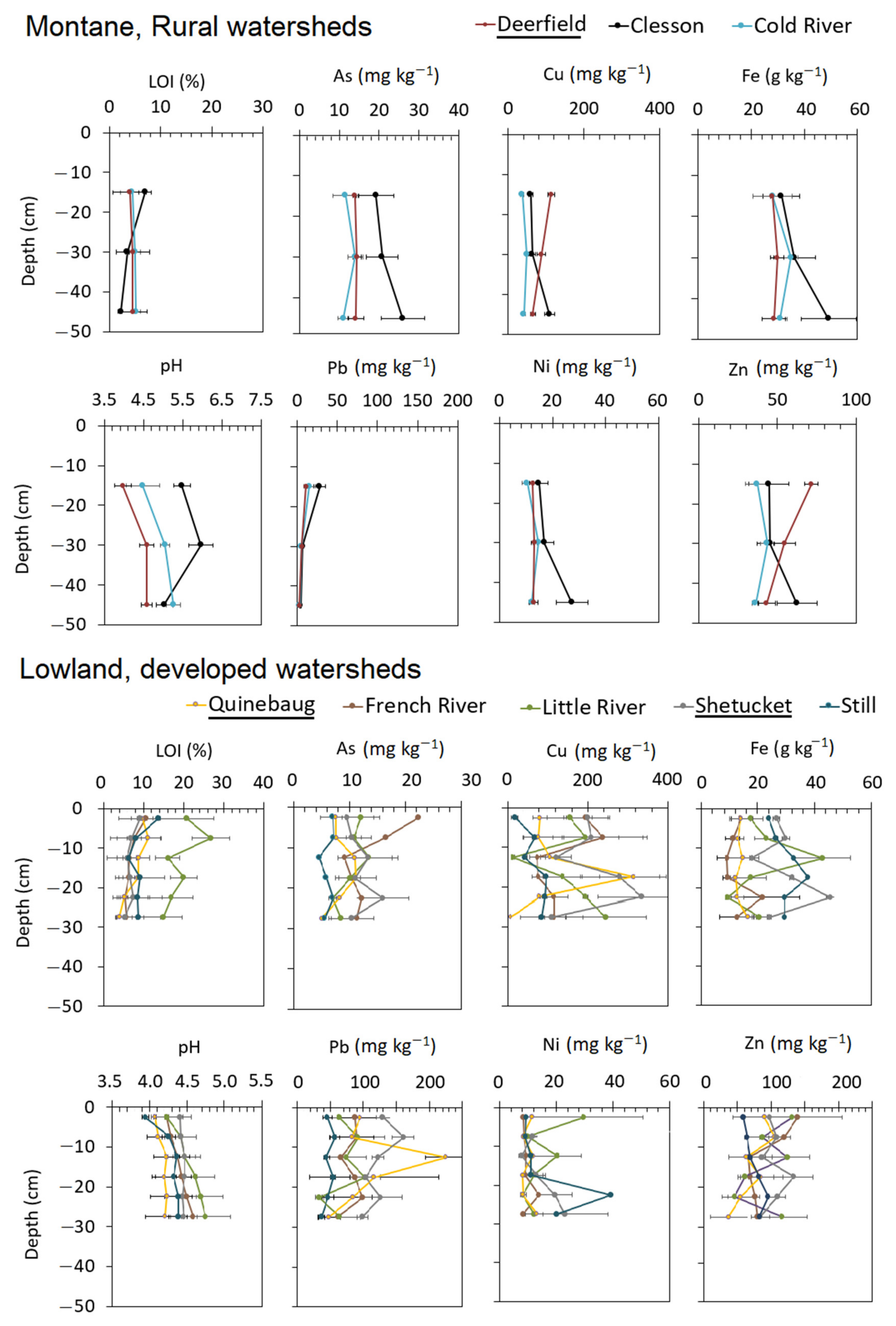
Upland soil pits showed some differences among the Deerfield, Quinebaug, and Shetucket watersheds. Using the Kruskal–Wallis test with post hoc Wilcoxon Signed Rank test, overall soil As concentrations were not significantly different within the three watersheds. Soil Cu concentrations were greater at developed Quinebaug and Shetucket watersheds than in the montane Deerfield (p < 0.05; Figure 2) across all soil depths. Further, overall soil Cu concentrations in the Little and French subwatersheds were higher than Clesson, and Cold watersheds (p < 0.05; Figure 2). Overall soil Fe concentrations were higher in the montane Deerfield watersheds than in the lowland Quinebaug watersheds (p < 0.05; Figure 2). Further, overall soil Fe concentrations were higher in Clesson and Cold watersheds than the French and Little subwatersheds (p < 0.05; Figure 2). Overall soil Ni concentrations were not significantly different among the three watersheds, but surface soils at Little and Shetucket watersheds were higher than in all of the Deerfield watershed (p < 0.05; Figure 2). Soil Pb concentrations were significantly higher throughout the more developed Quinebaug and Shetucket watersheds than in the Deerfield watershed (p < 0.05; Figure 2). Due the wide variability in soil Zn concentrations, there were no significant differences among the three watersheds. Overall soil LOI concentrations varied widely among the watersheds but was not significantly different among the three watersheds. Soil LOI was lowest in the Clesson (2 to 7%) and French (5 to 10%) subwatersheds and highest in the Little (15 to 27%) subwatershed. Overall soil pH was significantly higher in the Deerfield watershed (pH 4.0 to 6.0) compared to Quinebaug (pH 4.2 to 4.7) and Shetucket (pH 3.9 to 4.5) watersheds.

3.2. River Water Concentrations and Export

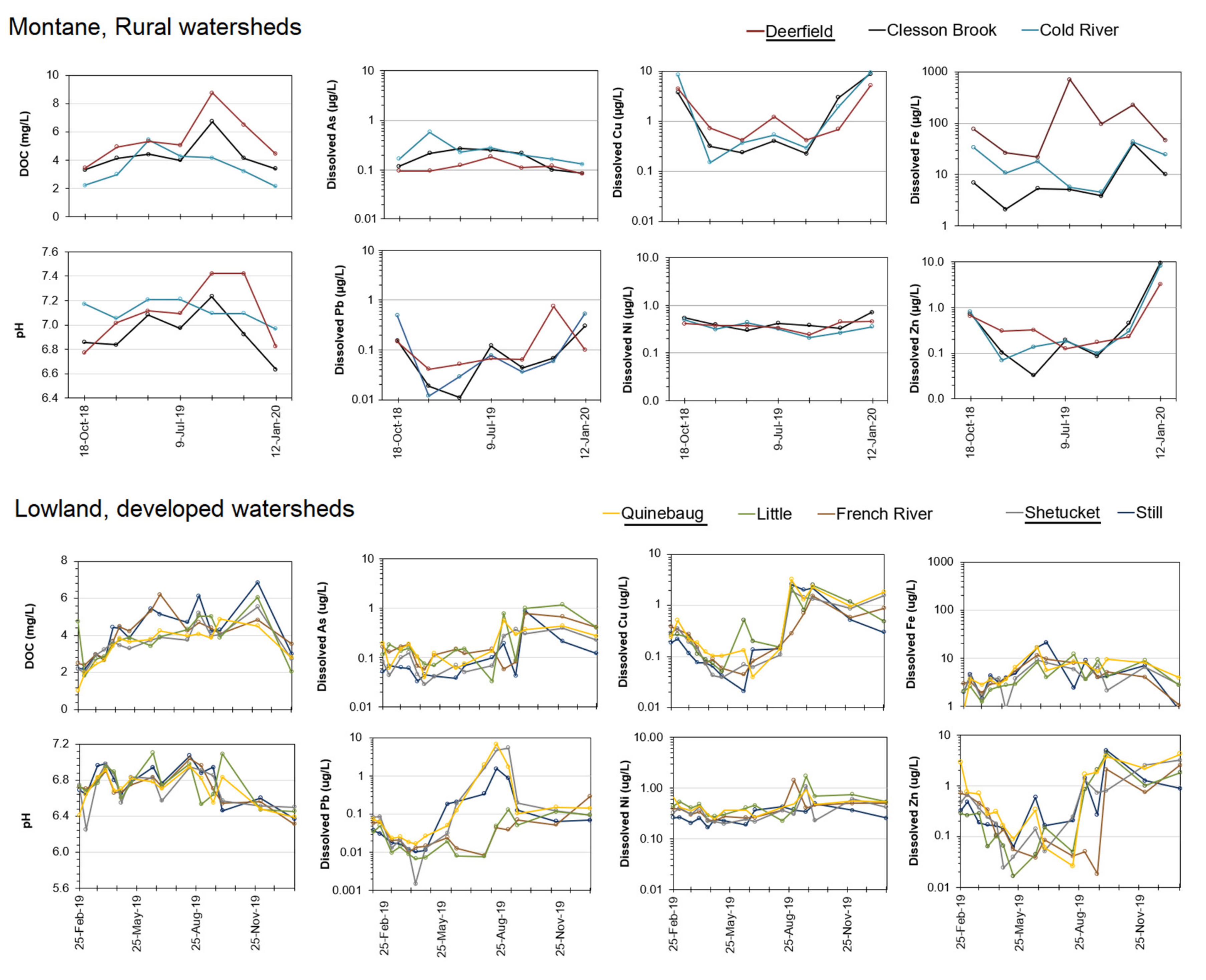
River concentrations exhibited many similarities between the montane, rural Deerfield watersheds and with the lowland, developed Quinebaug and Shetucket watersheds. Using the Kruskal–Wallis test with post hoc Wilcoxon Signed Rank test, average dissolved As concentrations were comparable among all of the watersheds, with averages ranging between 0.13 and 0.31 µg/L (p = 0.23). Average dissolved Cu was significantly higher for the Deerfield, Clesson, and Cold rivers (1.9 to 3.0 µg/L) compared to all Shetucket and Quinebaug rivers (0.4 to 0.8 µg/L) (p < 0.05). Average dissolved Fe concentration significantly higher for the Deerfield, Clesson, and Cold rivers (11 to 35 µg/L) than all Quinebaug and Shetucket rivers (4 to 6 µg/L). The average dissolved Pb concentrations were significantly greater for the Quinebaug and Shetucket rivers (0.24 to 0.86 µg/L), and lowest for the Deerfield, Cold, Clesson, French, Still and Little rivers (0.04 to 0.18 µg/L) (p < 0.05). Average dissolved Ni concentrations were comparable across all rivers (0.30 to 0.53 µg/L) (p = 0.17). Similarly, average dissolved Zn was comparable across all rivers (0.5 to 1.6 µg/L) (p = 0.34). To help provide context to the source of the trace elements, dissolved Al and dissolved Si, DOC, and water pH were also measured. Average dissolved Al was significantly greater for the Deerfield rivers (37 to 45 µg/L) compared to the Quinebaug and Shetucket rivers (1.4 to 2.2 µg/L) (p < 0.05). Similarly, average dissolved Si was much greater for the Deerfield rivers (1800 to 3537 µg/L) than the Quinebaug and Shetucket rivers (40 to 66 µg/L) (p < 0.05). Average DOC concentrations were greater for Deerfield river (4.8 to 7.3 mg/L) compared with Quinebaug river (1.0 to 4.9 mg/L) and Shetucket river (2.0 to 5.6 mg/L) (p < 0.05). Similarly, water pH was higher for the Deerfield river (pH 6.8 to 7.4) than the Quinebaug river (pH 6.4 to 7.0) and Shetucket river (pH 6.5 to 7.0) (p < 0.05).
Annual trace elements exports were determined using monthly summed discharge amounts from the USGS (except for Still River which was determined by its watershed area and data from similarly sized watersheds in the Thames River) and average concentrations from collected water samples and summed for an annual export rate (Table 2). Due to differences in area, total river export of As, Cu, Fe, Pb, Ni, and Zn was greatest for the Deerfield, Quinebaug, and Shetucket rivers due to their higher water discharge rates compared to the subwatersheds. The Deerfield river had the highest Cu, Fe, and DOC annual export rates while the Quinebaug river had the highest As, Pb, Ni, and Zn annual export rates (Table 2). To observe differences caused by land use and soils, the annual export rates were then normalized to their respective watershed area for comparisons across small and large watersheds. Once normalized to watershed area, different patterns can be observed. First, As exports were higher at Little and Quinebaug rivers and lower for the Still and Deerfield Rivers (Table 2). Copper exports were higher for the Deerfield watersheds compared to the Quinebaug and Shetucket watersheds (Table 2). Conversely, Fe exports were lower for the Deerfield watersheds compared to the Quinebaug and Shetucket watersheds (Table 2). Lead export was higher for the Quinebaug River, similar rates for the Deerfield, Cold, and Shetucket rivers and lower for Clesson, French, and Little Rivers (Table 2). Nickel export was largely similar across all the watersheds, with export ranging from 0.14 to 0.58 kg/yr/km2. Lastly, Zn export was greatest for the Quinebaug river, similar ranges among Clesson and Cold River, and lowest for Deerfield, French, Little, Shetucket, and Still rivers. Normalized export of DOC was higher for Deerfield river (4.9 Mg/yr/km2) compared with Quinebaug river (4.3 Mg/yr/km2) and Shetucket river (2.7 Mg/yr/km2). Lastly, to provide further context to the trace element sources, Al, K, and Si annual export rates were also investigated (Table 3). The Deerfield watersheds had higher normalized Al, Si and K export rates were greater than the Quinebaug and Shetucket subwatersheds (Table 3).

3.3. Linear Regressions and Principal Component Analysis

Pearson linear regressions were calculated to examine relationships among median trace element soil concentrations, normalized dissolved trace element exports, and land use across the watersheds (Table 4). Across all watersheds, median soil concentrations of Pb, Cu, and Zn were positively correlated with each other and As and Ni were positively correlated with each other but the two groups of soil concentrations were negatively correlated. Normalized dissolved exports of As, Cu, Ni, Pb, and Zn were largely positively correlated with each other. Only normalized dissolved Fe was positively correlated with soil Fe, but normalized dissolved exports were negatively or not significantly correlated with median soil concentrations for the other trace elements. Examining land use across the watersheds, it can be observed that wetland% was positively correlated with normalized dissolved Fe, Ni and Pb exports. The forest% was negatively correlated with normalized dissolved As, Ni, and Pb exports, but positively correlated with normalized dissolved Cu export. Low/Medium development and high development intensities were positively correlated with soil Pb and Zn but not correlated with any normalized dissolved trace element export.
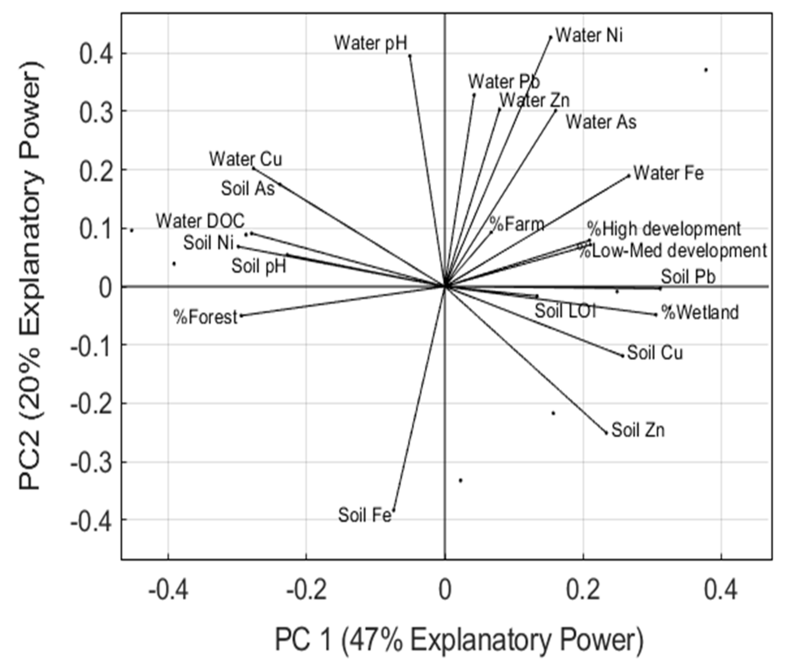
Lastly, the variance in watershed data was examined using a principal component analysis of median trace element soil concentrations, normalized dissolved trace element exports, and land use across the watersheds. The results show that soil Pb concentrations, wetland%, high development%, low–medium development%, soil Cu and soil Zn drive the positive variance in PC1 while forest%, soil As, Ni, dissolved Cu and Fe export drive the negative variance in PC1. Furthermore, dissolved Zn, Pb, Ni, and As, drive the positive variance in the PC2 while Soil Fe, and Zn drive the negative variance in PC2. (Table 5).

4. Discussion

4.1. Soil–River Water Linkage

The first hypothesis was that river export of trace elements across the different watersheds would be dependent on the abundance of trace elements in their soils. The results suggest that this is partially the case for some elements. Soils in the Deerfield watersheds had higher Fe soil and river Fe water concentrations than in the Quinebaug and Shetucket watersheds (Figure 2 and Figure 3). Conversely, soils in the Quinebaug and Shetucket watersheds had higher Pb soil and river water concentrations than in the Deerfield watersheds (Figure 2 and Figure 3). Further, Deerfield river had higher soil pH was correlated with higher river water pH (Table 4). At face value, this suggests that the abundance of Fe, Pb, and pH in the soils is directly linked with river water. When evaluating this relationship as annual export normalized to the area of the watershed, the relationships between soil Fe and Pb with river water Fe and Pb are no longer observable. Linear regressions of median soil concentrations to normalized dissolved did not show a significant correlation for most of the trace elements. Although median soil Cu concentrations were significantly correlated with river water Cu concentrations (Table 4), the principal component analysis suggests the relationship is more complex as their variance was negatively related for both PC1 and PC2 (Figure 4).
The variation in soil chemical properties only partially associated with trace element retention and transport. The negative linear correlations and PCA results between soil pH and soil Cu, Pb, and Zn concentrations suggests more acidic soils stored less Pb, Cu, and Zn (Table 4, Figure 4). The positive correlation and PCA results suggest a link between soil LOI and soil Cu, Pb, and Zn (Table 4, Figure 4). However, instead of a direct causal link of SOM promoting trace element retention, soils with higher LOI occurred in watersheds with higher proportion of human developments. Thus, the SOM-trace element relationship may be dominated by indirect effects of pollution and human development. Water pH was negatively correlated with Fe exports, suggesting that as pH decreased, exports of dissolved Fe increased likely due to higher solubility [20]. Water pH was positively correlated with normalized dissolved Cu exports, which is converse to solubility and weathering effects and may be due human pollution or mineral dissolution (discussed in Section 4.3). Lastly, normalized water DOC exports was not correlated with average soil LOI across the watersheds, suggesting that production of DOC was not related to abundance in soil. However, normalized water DOC export was positively correlated with normalized dissolved Pb and Ni exports, showing that organic colloidal transport was likely an important factor in their transport in rivers.
It should be noted that the experimental design has several drawbacks as depth and length of soil flow paths, soil leachate and porewaters, deep soil weathering (> 50 cm depth), and particulate-mediated processes (i.e., erosion and colloid transport) were not investigated. Colloids larger than 0.45 µm were not evaluated in this study and may be important for transport of trace elements by rivers through a watershed. Moreover, speciation of the trace elements and sorption capacity of the soils were indirectly evaluated while the species of trace elements and availability for sorption is important. This study focused on only soil solid phase samples from a small subset of locations within the watershed and limited sampling of dissolved river trace elements. In spite of the limitations in study design, these results suggest that soil concentrations are not strong predictors of trace element export to rivers across eight watersheds.

4.2. Land-Use Impacts on Soil–River Linkages

In the second hypothesis, it was expected that land use would impact the trace element linkage between soil and water by acting as sources or sinks. It was observed that soil Pb and Zn concentrations were significantly related to the abundance of low/medium, and high development intensities across the eight watersheds (Table 4). This agrees with the well-established relationship that human land use, such as roadways, private residences, commercial uses, and industrial manufacturing, acts as a source of trace element pollutants like Pb and Zn [34,35]. Soil pH and Fe concentrations were negatively correlated with human development intensities. Soil pH may be negatively correlated due to localized acid deposition from human activities and soil Fe is likely controlled by geologic and pedologic processes. Soil Ni concentrations were expected to also be related to human land use but was negatively correlated with low/medium and high development intensities. Instead of human pollution controlling soil Ni, that pedologic or geologic processes may be most important for Ni in soil. Lastly, watersheds with a higher proportion of low/medium and high development intensities did not have higher normalized dissolved export rates of any trace element (Table 4). This finding disagrees with numerous previous studies [17,36,37] but agrees with other studies that did not find a link between land use and river trace elements [38]. This may have arisen from either dilution effects masking anthropogenic contributions in the larger, more urbanized watersheds or the anthropogenic intensity in trace element pollution does not scale with area of development. In other words, a single large polluter can disproportionally affect river water [39] and detecting urban impacts in larger rivers can be more difficult due to point sources [40].
Normalized dissolved export rates of Ni and Pb were positively correlated with wetland abundance and dissolved export of As was positively correlated with farmland abundance (Table 4). Arsenic and Cu export may be higher in agricultural areas due to their use as pesticides [3,41]. The relationship between Ni and Pb appears counterintuitive as wetlands can be important sinks for trace elements in watersheds [42,43]. However, wetlands may be a source of historical pollution remobilization from dam removal, changes in sediment impoundment, and physical management of wetlands [44,45]. Forests had more extensive set of correlations; watersheds with higher forest abundance had higher soil Fe and normalized dissolved export of Fe (Table 4). Moreover, watersheds with more forests had lower Cu, Pb, and Zn in their soils and lower normalized dissolved exports of Cu, Pb, and Zn, likely due to less human development and subsequent pollution and higher retention by soil Fe oxides. Further, watersheds with higher forest abundance had higher soil As concentrations but lower normalized As export. These results suggest that forest soils play an important role in regulating the dissolved export of As, Cu, Pb, and Zn, with Fe as a potential mediator of their export.

4.3. Geologic Controls on Soil–River Linkage

In the last hypothesis, it was postulated that geologic and pedologic processes could control the soil–surface water link for trace elements. To begin unravelling the differences in geological processes, the normalized annual dissolved export of Al, K, and Si was compared between Deerfield to Quinebaug and Shetucket watersheds. On the basis of the normalized annual Al, K, and Si dissolved exports, the Deerfield watersheds are undergoing more intensive weathering and/or greater export of dissolved solutes. The dissolved Si results largely agree with the overlapping watersheds studied in New England by Carey and Fulweiler [46], which found exports to be: French River (1.2 Mg/yr/km2), Still River (1.5 Mg/yr/km2), and Quinebaug (1.6 Mg/yr/km2). However, the results from this study suggest that geologic and pedologic processes substantially influence dissolved transports of elements more than humans. An important difference is that this study contrasted more montane watersheds, while Carey and Fulweiler [46] predominantly investigated less montane and less forested watersheds.
There are several potential causes for the enhanced weathering and/or export of dissolved trace elements in the montane, Deerfield watersheds. First, the soils are shallow and the valley sides are steep in the Deerfield watershed, which promotes faster transport from soils to surface waters as opposed to the low relief in the lowlands with deeper transport pathways [27,47,48]. Second, the higher proportion of forest and higher DOC in the Deerfield watersheds could cause greater dissolution rates of minerals and complexation of trace elements [47,48,49]. The higher silicate dissolution rates in the Deerfield watershed may be responsible for greater trace element release, which may explain why export rates of pollutant metals (e.g., Cu and Zn) were not correlated with human development.

5. Conclusions and Implications

This study highlights that the soil–surface water link for trace elements is complex: soil concentrations were a weak predictor, land uses partially explain the relationship, and geologic/pedologic processes may be a dominant, poorly constrained variable. Soil concentrations were an important predictor for only dissolved Fe export, but none of the other trace elements. The limited spatial and depth of soil sampling may contribute to the poor relationships as localized effects may be most important for trace element sourcing and transport. The weathering interface at greater depths (bottom of glacial till, bedrock) may be an important zone of trace element release from rocks and soil parent material (see Richardson and King, 2018) and was poorly constrained in this study. Bedrock geochemical differences may also play into the greater normalized trace element export for the Deerfield watershed. In previous experiments in the region, forest area was an important predictor for sequestering trace elements and was negatively correlated with dissolved exports of As, Fe, Ni, and Pb [4,46]. Surprisingly, development area was not significantly correlated with pollutant trace elements in dissolved concentrations. As suggested by the principal component analysis, land use explained soil concentrations but was not explanatory for dissolved trace element export. From normalized dissolved exports of Al, K, and Si, enhanced weathering and mineral dissolution in the montane watershed was likely an important factor. Although key data to evaluate groundwater transport, hyporheic exchange, and flow path lengths were not collected here, the narrow valleys with shallow soils likely accelerated the transport of dissolved trace elements from soils to surface waters. Additional studies are needed to investigate these potential geologic controls.

Funding

This study was funded by the College of Natural Sciences at the University of Massachusetts Amherst.

Institutional Review Board Statement

Not applicable.

Informed Consent Statement

Not applicable.

Conflicts of Interest

The author state that work was conducted without any personal, professional, or financial relationships that could potentially be construed as a conflict of interest.

References

  1. Bricker, S.B. The history of Cu, Pb, and Zn inputs to Narragansett Bay, Rhode Island as recorded by salt-marsh sediments. Estuaries 1993, 16, 589–607. [Google Scholar] [CrossRef]
  2. Davis, A.; Kempton, J.H.; Nicholson, A.; Yare, B. Groundwater transport of arsenic and chromium at a historical tannery, Woburn, Massachusetts, USA. Appl. Geochem. 1994, 9, 569–582. [Google Scholar] [CrossRef]
  3. Aurilio, A.C.; Durant, J.L.; Hemond, H.F.; Knox, M.L. Sources and distribution of arsenic in the Aberjona watershed, eastern Massachusetts. Water Air Soil Pollut. 1995, 81, 265–282. [Google Scholar] [CrossRef]
  4. Breault, R.F.; Harris, S.L. Geographical Distribution and Potential for Adverse Biological Effects of Selected Trace Elements and Organic Compounds in Streambed Sediment in the Connecticut, Housatonic, and Thames River Basins, 1992–1994; No. 4169; US Department of the Interior, US Geological Survey: Reston, VA, USA, 1997; Volume 97. [Google Scholar]
  5. Adriano, D.C. Arsenic. In Trace Elements in Terrestrial Environments; Springer: New York, NY, USA, 2001; pp. 219–261. [Google Scholar]
  6. Richardson, J.B.; King, E.K. Regolith weathering and sorption influences molybdenum, vanadium, and chromium export via stream water at four granitoid Critical Zone Observatories. Front. Earth Sci. 2018, 6, 193. [Google Scholar] [CrossRef]
  7. Ravera, O.; Cenci, R.; Beone, G.M.; Dantas, M.; Lodigiani, P. Trace element concentrations in freshwater mussels and macrophytes as related to those in their environment. J. Limnol. 2003, 62, 61–70. [Google Scholar] [CrossRef] [Green Version]
  8. Vardy, D.W.; Oellers, J.; Doering, J.A.; Hollert, H.; Giesy, J.P.; Hecker, M. Sensitivity of early life stages of white sturgeon, rainbow trout, and fathead minnow to copper. Ecotoxicology 2013, 22, 139–147. [Google Scholar] [CrossRef]
  9. Jović, M.; Stanković, S. Human exposure to trace metals and possible public health risks via consumption of mussels Mytilus galloprovincialis from the Adriatic coastal area. Food Chem. Toxicol. 2014, 70, 241–251. [Google Scholar] [CrossRef]
  10. Ibemenuga, K.N. Bioaccumulation and toxic effects of some heavy metals in freshwater fishes. Anim. Res. Int. 2013, 10, 1792–1798. [Google Scholar]
  11. Varekamp, J.C.; McElroy, A.E.; Mullaney, J.R.; Breslin, V.T. Metals, organic compounds, and nutrients in Long Island Sound: Sources, magnitudes, trends, and impacts. In Long Island Sound; Springer: New York, NY, USA, 2014; pp. 203–283. [Google Scholar]
  12. Connecticut Department of Energy and Environmental Protection [CT DEEP]. Long Island Sound Blue Plant. 2019. Available online: https://portal.ct.gov/DEEP/Coastal-Resources/LIS-Blue-Plan/Blue-Plan-Basic-Background (accessed on 1 October 2020).
  13. Berggren, D.; Bergkvist, B.; Falkengren-Grerup, U.; Folkeson, L.; Tyler, G. Metal solubility and pathways in acidified forest ecosystems of south Sweden. Sci. Total Environ. 1990, 96, 103–114. [Google Scholar] [CrossRef]
  14. Ge, Y.; Murray, P.; Hendershot, W.H. Trace metal speciation and bioavailability in urban soils. Environ. Pollut. 2000, 107, 137–144. [Google Scholar] [CrossRef]
  15. Gandois, L.; Probst, A.; Dumat, C. Modelling trace metal extractability and solubility in French forest soils by using soil properties. Eur. J. Soil Sci. 2010, 61, 271–286. [Google Scholar] [CrossRef] [Green Version]
  16. Adamo, P.; Zampella, M.; Gianfreda, L.; Renella, G.; Rutigliano, F.A.; Terribile, F. Impact of river overflowing on trace element contamination of volcanic soils in south Italy: Part I. Trace element speciation in relation to soil properties. Environ. Pollut. 2006, 144, 308–316. [Google Scholar] [CrossRef] [PubMed]
  17. Das, B.; Nordin, R.; Mazumder, A. Watershed land use as a determinant of metal concentrations in freshwater systems. Environ. Geochem. Health 2009, 31, 595–607. [Google Scholar] [CrossRef] [PubMed]
  18. Stolpe, B.; Guo, L.; Shiller, A.M.; Aiken, G.R. Abundance, size distributions and trace-element binding of organic and iron-rich nanocolloids in Alaskan rivers, as revealed by field-flow fractionation and ICP-MS. Geochim. Cosmochim. Acta 2013, 105, 221–239. [Google Scholar] [CrossRef]
  19. Tamrat, W.Z.; Rose, J.; Grauby, O.; Doelsch, E.; Levard, C.; Chaurand, P.; Basile-Doelsch, I. Soil organo-mineral associations formed by co-precipitation of Fe, Si and Al in presence of organic ligands. Geochim. Cosmochim. Acta 2019, 260, 15–28. [Google Scholar] [CrossRef]
  20. Pédrot, M.; Dia, A.; Davranche, M.; Bouhnik-Le Coz, M.; Henin, O.; Gruau, G. Insights into colloid-mediated trace element release at the soil/water interface. J. Colloid Interface Sci. 2008, 325, 187–197. [Google Scholar] [CrossRef]
  21. Mistikawy, J.A.; Mackowiak, T.J.; Butler, M.J.; Mischenko, I.C.; Cernak, R.S.; Richardson, J.B. Chromium, manganese, nickel, and cobalt mobility and bioavailability from mafic-to-ultramafic mine spoil weathering in western Massachusetts, USA. Environ. Geochem. Health 2020, 42, 3263–3279. [Google Scholar] [CrossRef]
  22. Wilhelm, J.F.; Bain, D.J.; Green, M.B.; Bush, K.F.; McDowell, W.H. Trace metals in Northern New England streams: Evaluating the role of road salt across broad spatial scales with synoptic snapshots. PLoS ONE 2019, 14, e0212011. [Google Scholar] [CrossRef]
  23. Chrysochoou, M.; Ferreira, D.R.; Johnston, C.P. Calcium polysulfide treatment of Cr (VI)-contaminated soil. J. Hazard Mater. 2010, 179, 650–657. [Google Scholar] [CrossRef]
  24. Lindbo, D.L.; Veneman, P.L.M. Morphological and physical properties of selected fragipan soils in Massachusetts. Soil Sci. Soc. Am. J. 1993, 57, 429–436. [Google Scholar] [CrossRef]
  25. Metzler, K.J.; Tiner, R.W. Wetlands of Connecticut; State Geological and Natural History Survey of Connecticut, Department of Environmental Protection: Hartford, CT, USA, 1992.
  26. Lindbo, D.L.; Brigham-Grette, J.; Veneman, P.L. Depositional and Post-Depositional Features in the Late Illinoian and Late Wisconsinan Tills of Massachusetts. Whole Regolith Pedol. 1994, 34, 75–95. [Google Scholar]
  27. Friesz, P.J. Geohydrology of Stratified Drift and Streamflow in the Deerfield River Basin, northwestern Massachusetts; No. 4115; US Department of the Interior, US Geological Survey: Reston, VA, USA, 1996; Volume 96. [Google Scholar]
  28. Jin, S.; Homer, C.; Yang, L.; Danielson, P.; Dewitz, J.; Li, C.; Zhu, Z.; Xian, G.; Howard, D. Overall methodology design for the United States national land cover database 2016 products. Remote Sens. 2019, 11, 2971. [Google Scholar] [CrossRef] [Green Version]
  29. Zen, E.A.; Goldsmith, R.; Ratcliffe, N.M.; Robinson, P.; Stanley, R.S. Bedrock geologic map of Massachusetts: US Geological Survey and the Commonwealth of Massachusetts. Department of Public Works, scale, 1(2), 1983.
  30. Marek, R.S.; Richardson, J.B. Investigating surficial geologic controls on soil properties, inorganic nutrient uptake, and northern hardwood growth in Western Massachusetts, USA. J. Soil Sci. Plant Nutr. 2020, 20, 901–911. [Google Scholar] [CrossRef]
  31. Rodgers, J. Bedrock geological map of Connecticut: Hartford. Connecticut, Connecticut Geological and Natural History Survey, Connecticut Natural Resources Atlas Series, scale, 1(250,000), 1985.
  32. Chen, M.; Ma, L.Q. Comparison of four USEPA digestion methods for trace metal analysis using certified and Florida soils. J. Environ. Qual. 1998, 27, 1294–1300. [Google Scholar] [CrossRef]
  33. U.S. Geological Survey (USGS). Collection of Water Samples (ver. 2.0): U.S Geological Survey Techniques of Water-Resources Investigations. 2006. Available online: http://pubs.water.usgs.gov/twri9A4/ (accessed on 17 September 2020).
  34. Marsh, A.S.; Siccama, T.G. Use of formerly plowed land in New England to monitor the vertical distribution of lead, zinc and copper in mineral soil. Water Air Soil Pollut. 1997, 95, 75–85. [Google Scholar] [CrossRef]
  35. Richardson, J.B.; Friedland, A.J.; Kaste, J.M.; Jackson, B.P. Forest floor lead changes from 1980 to 2011 and subsequent accumulation in the mineral soil across the northeastern United States. J. Environ. Qual. 2014, 43, 926–935. [Google Scholar] [CrossRef] [PubMed]
  36. Tiefenthaler, L.L.; Stein, E.D.; Schiff, K.C. Watershed and land use–based sources of trace metals in urban storm water. Environ. Toxicol. Chem. Int. J. 2008, 27, 277–287. [Google Scholar] [CrossRef] [Green Version]
  37. Zeng, Y.; Bi, C.; Jia, J.; Deng, L.; Chen, Z. Impact of intensive land use on heavy metal concentrations and ecological risks in an urbanized river network of Shanghai. Ecol. Indic. 2020, 116, 106501. [Google Scholar] [CrossRef]
  38. Karouna-Renier, N.K.; Sparling, D.W. Relationships between ambient geochemistry, watershed land-use and trace metal concentrations in aquatic invertebrates living in stormwater treatment ponds. Environ. Pollut. 2001, 112, 183–192. [Google Scholar] [CrossRef]
  39. Zhang, C.; Qiao, Q.; Piper, J.D.; Huang, B. Assessment of heavy metal pollution from a Fe-smelting plant in urban river sediments using environmental magnetic and geochemical methods. Environ. Pollut. 2011, 159, 3057–3070. [Google Scholar] [CrossRef]
  40. Chen, Q.; Mei, K.; Dahlgren, R.A.; Wang, T.; Gong, J.; Zhang, M. Impacts of land use and population density on seasonal surface water quality using a modified geographically weighted regression. Sci. Total Environ. 2016, 572, 450–466. [Google Scholar] [CrossRef] [PubMed] [Green Version]
  41. Davenport, J.R.; Peryea, F.J. Phosphate fertilizers influence leaching of lead and arsenic in a soil contaminated with lead arsenate. Water Air Soil Pollut. 1991, 57, 101–110. [Google Scholar] [CrossRef]
  42. Puckett, L.J.; Woodside, M.D.; Libby, B.; Schening, M.R. Sinks for trace metals, nutrients, and sediments in wetlands of the Chickahominy River near Richmond, Virginia. Wetlands 1993, 13, 105–114. [Google Scholar] [CrossRef]
  43. Weis, J.S.; Weis, P. Metal uptake, transport and release by wetland plants: Implications for phytoremediation and restoration. Environ. Int. 2004, 30, 685–700. [Google Scholar] [CrossRef] [PubMed]
  44. Allinson, G.; Zhang, P.; Bui, A.; Allinson, M.; Rose, G.; Marshall, S.; Pettigrove, V. Pesticide and trace metal occurrence and aquatic benchmark exceedances in surface waters and sediments of urban wetlands and retention ponds in Melbourne, Australia. Environ. Sci. Pollut. Res. 2015, 22, 10214–10226. [Google Scholar] [CrossRef]
  45. Monnin, L.; Ciffroy, P.; Garnier, J.M.; Ambrosi, J.P.; Radakovitch, O. Remobilization of trace metals during laboratory resuspension of contaminated sediments from a dam reservoir. J. Soils Sediments 2018, 18, 2596–2613. [Google Scholar] [CrossRef]
  46. Carey, J.C.; Fulweiler, R.W. Human activities directly alter watershed dissolved silica fluxes. Biogeochemistry 2012, 111, 125–138. [Google Scholar] [CrossRef]
  47. Anderson, S.P.; Dietrich, W.E. Chemical weathering and runoff chemistry in a steep headwater catchment. Hydrol. Process. 2001, 15, 1791–1815. [Google Scholar] [CrossRef] [Green Version]
  48. Wilson, H.F.; Raymond, P.A.; Saiers, J.E.; Sobczak, W.V.; Xu, N. Increases in humic and bioavailable dissolved organic matter in a forested New England headwater stream with increasing discharge. Mar. Freshw. Res. 2016, 67, 1279–1292. [Google Scholar] [CrossRef]
  49. Augusto, L.; Turpault, M.P.; Ranger, J. Impact of forest tree species on feldspar weathering rates. Geoderma 2000, 96, 215–237. [Google Scholar] [CrossRef]
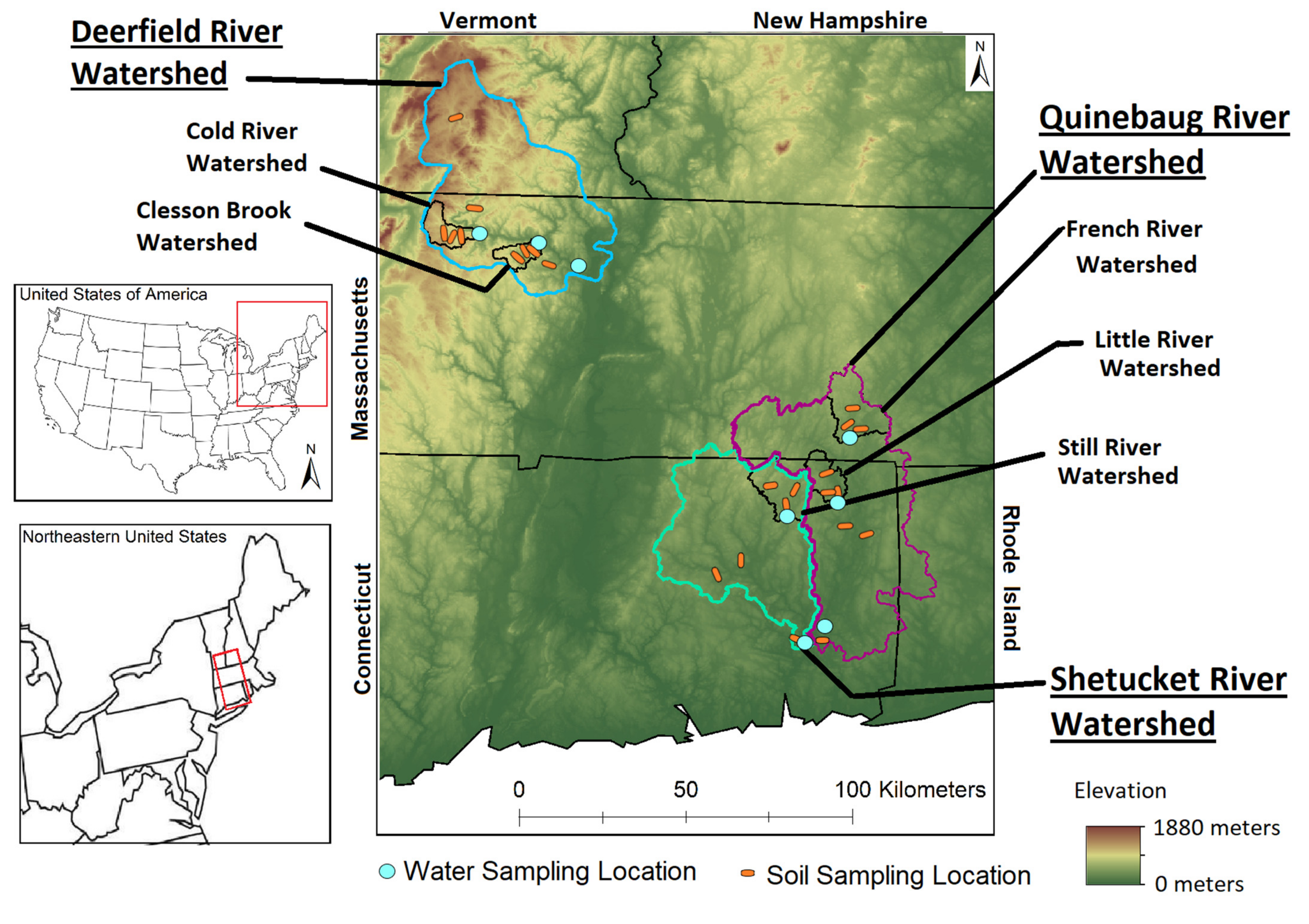
Figure 1. Digital elevation map and soil and water sampling locations in the Deerfield watersheds (and two of subwatersheds Cold River, Clesson Brook) of northwestern Massachusetts and the lowland, urbanized Quinebaug (and two subwatersheds Little and French River) and Shetucket watersheds (and its subwatershed Still River) of eastern Connecticut.
Water 13 00059 g001
Figure 2. Soil trace element concentrations for upland soil profiles sampled within each of the subwatersheds (N = 3) and in the three main watersheds (Deerfield N = 9, Quinebaug N = 9, Shetucket N = 6). Error bars are the standard errors among the soils at each watershed or subwatershed.
Water 13 00059 g002
Figure 3. River water pH, DOC, and dissolved trace element concentrations in the montane, Deerfield watersheds of northwestern Massachusetts and in the lowland, Quinebaug and Shetucket watersheds of eastern Connecticut. Please note the different collection dates and linear scale for DOC. River water samples were filtered to < 0.45 µm.
Water 13 00059 g003
Figure 4. Principal component analysis of median soil trace element concentrations (abbreviated ‘soil’), median dissolved trace element normalized annual exports (abbreviated ‘water’), soil chemical properties (pH and LOI), water parameters (pH and DOC), and watershed land cover data for farms, forests, wetlands, low–medium development intensity, and high development intensity for each watershed.
Water 13 00059 g004
Table 1. River water samples were analyzed using a Hach SensIon+ portable meter for pH, oxidation-reduction potential, and electrical conductivity (Hach, Loveland, CO, USA). The remaining subsample was acidified to pH using HCl and analyzed for non-particulate dissolved organic carbon (DOC) using a TOC-L Shimadzu total carbon analyzer. Blanks were below detection (<0.01 mg/L), duplicates were within 2% CV, and spike recoveries were 92–103%. Watershed and subwatershed properties.
RiverWatershed AreaDischarge Forest AreaFarmlandWetlandLow–Medium DevelopmentHigh Development
km2km3/yr%%%%%
Deerfield17221.29825420.080
Clesson55.60.048111210.007
Cold81.90.06901410.001
Quinebaug10321.396171450.450
French2610.2058411100.985
Little780.0660171320.091
Shetucket13621.057161040.258
Still1430.037641110.004
Annual discharge was discharge for the sampling period and was obtained from USGS gauge data for Deerfield River, Clesson Brook, Cold River, Quinebaug River, French River, Little River, and Shetucket River. Still River was not gauged and its discharge rates were estimated using linear regressions from watersheds of similar size within the greater Thames River watershed.
Table 2. Watershed trace element annual export and normalized annual export rates.
ArsenicCopperIronLeadNickelZinc
kg/yrkg/yr/km2kg/yrkg/yr/km2kg/yrkg/yr/km2kg/yrkg/yr/km2kg/yrkg/yr/km2kg/yrkg/yr/km2
Deerfield1510.0924161.4580.033310.194920.299420.55
Clesson70.12901.60.50.0140.07170.30591.07
Cold140.171682.11.40.02130.16190.23790.96
Quinebaug2850.285610.51900.183820.376030.5815631.51
French460.18500.2220.0890.03820.31710.27
Little240.31260.35.80.0720.03280.35290.37
Shetucket1450.113210.21000.071870.143420.258110.60
Still60.04180.1100.07110.08210.14350.24
Table 3. Watershed major elements and dissolved organic carbon (DOC) annual export and normalized annual export rates.
AluminumPotassiumSiliconDOC
Mg/yrMg/yr/km2Gg/yrMg/yr/km2Gg/yrMg/yr/km2Mg/yrMg/yr/km2
Deerfield92.90.0510.246.03.42.083604.9
Clesson4.80.090.9717.40.47.21372.5
Cold6.20.080.566.80.22.41872.3
Quinebaug610.062.472.42.32.343894.3
French100.040.311.20.20.97722.9
Little4.40.060.162.00.11.53063.9
Shetucket480.042.251.71.71.336482.7
Still3.60.020.050.40.21.12922.0
Table 4. Matrix of Pearson’s (R) correlation coefficient of trace elements in soil concentrations (abbreviated ‘soil’), soil chemical properties (pH and LOI), normalized dissolved watershed exports (abbreviated ‘water’), and water chemical properties (pH and normalized DOC exports).
Soil CuSoil FeSoil NiSoil PbSoil ZnSoil pHSoil LOIWater AsWater CuWater FeWater NiWater PbWater ZnWater pHWater DOC
Soil As−0.6−0.30.9−0.7−0.70.9−0.4−0.20.7−0.6−0.1−0.20.30.60.0
Soil Cu 0.1−0.70.80.7−0.40.60.5−0.80.80.2−0.2−0.4−0.80.1
Soil Fe 0.1−0.20.30.00.0−0.6−0.10.5−0.7−0.3−0.30.0−0.5
Soil Ni −0.9−0.80.8−0.3−0.40.8−0.3−0.3−0.20.20.8−0.1
Soil Pb 0.7−0.70.30.5−0.90.80.50.1−0.1−0.90.1
Soil Zn −0.60.0−0.1−0.90.5−0.1−0.1−0.4−0.8−0.1
Soil pH −0.2−0.10.6−0.7−0.2−0.40.20.5−0.3
Soil LOI 0.6−0.40.20.2−0.3−0.3−0.30.3
Water As −0.10.50.80.20.3−0.30.4
Water Cu 0.60.70.30.50.90.0
Water Fe 0.80.60.3−0.70.4
Water Ni 0.70.7−0.30.6
Water Pb 0.80.00.5
Water Zn 0.10.2
Water pH 0.1
Water DOC
Coefficients in bold and in color are significant at p < 0.05, with red indicating significant negative correlations and blue indicating significant positive correlations.
Table 5. Matrix of Pearson’s (R) correlation coefficient of trace elements in soil concentrations (abbreviated ‘soil’), normalized dissolved watershed exports (abbreviated ‘Normalized Water Exports’), and watershed land use. Coefficients in color are significant at p < 0.05, with red indicating significant negative correlations and blue indicating significant positive correlations.
Watershed Land Use
WetlandForestFarmLow/Med Develop.High Develop.
Soil As−0.40.50.1−0.2−0.2
Soil Cu0.3−0.80.50.40.4
Soil Fe0.00.6−0.1−0.6−0.6
Soil Ni−0.50.80.1−0.6−0.6
Soil Pb0.5−0.90.20.70.7
Soil Zn0.6−0.6−0.10.50.5
Soil pH−0.5−0.3−0.4−0.6−0.5
Soil LOI−0.3−0.3−0.2−0.3−0.3
Water As0.1−0.60.60.30.3
Water Cu−0.30.8−0.2−0.2−0.2
Water Fe0.7−0.70.10.30.3
Water Ni0.5−0.50.30.30.3
Water Pb0.7−0.5−0.30.00.0
Water Zn0.40.20.0−0.1−0.1
Water pH0.40.10.30.40.3
Water DOC−0.40.2−0.1−0.6−0.5
Publisher’s Note: MDPI stays neutral with regard to jurisdictional claims in published maps and institutional affiliations.