Article

Geomorphic Approaches to Estimate Short-Term Erosion Rates: An Example from Valmarecchia River System (Northern Apennines, Italy)

by
Veronica Guerra
1,* and
Maurizio Lazzari
2
1
Department of Pure and Applied Sciences, University “Carlo Bo”, via Ca’ le Suore 2, 61029 Urbino, Italy
2
CNR ISPC, C/da S. Loja Zona Industriale, 85050 Tito Scalo, Italy
*
Author to whom correspondence should be addressed.
Water 2020, 12(9), 2535; https://doi.org/10.3390/w12092535
Submission received: 27 July 2020 / Revised: 22 August 2020 / Accepted: 9 September 2020 / Published: 11 September 2020
(This article belongs to the Special Issue GIS Application in Fluvial Geomorphology and Landscape Changes)

Abstract

:
Studying fluvial dynamics and environments, GIS-based analyses are of fundamental importance to evaluate the network geometry and possible anomalies, and can be particularly useful to estimate modifications in processes and erosion rates. The aim of this paper is to estimate short-term erosion rates attributable to fluvial processes in two sample catchment sub-basins of the Marecchia river valley, by conducting quantitative morphometric analyses in order to calculate various descriptive parameters of the hierarchisation of the river networks and the mean turbid transport of streams (Tu). Sediment yield transported by streams can in fact partially express the amount of erosional processes acting within the drainage basin. The study area includes two sub-basins of the Marecchia valley (Senatello river, 49 km2 and Mazzocco river, 47 km2), chosen because of their similar extent and of the different location in the major catchment basin. Starting from geomorphological maps of the two river basins, the Tu parameter has been calculated and converted in short-term rate (average value 0.21 mm/year). Moreover, the comparison of these short-term mean data with the uplift rates calculated on a regional scale (0.41 ± 0.26 mm/year) in the Marecchia valley confirms that the northern Apennines may represent a non-steady state system.

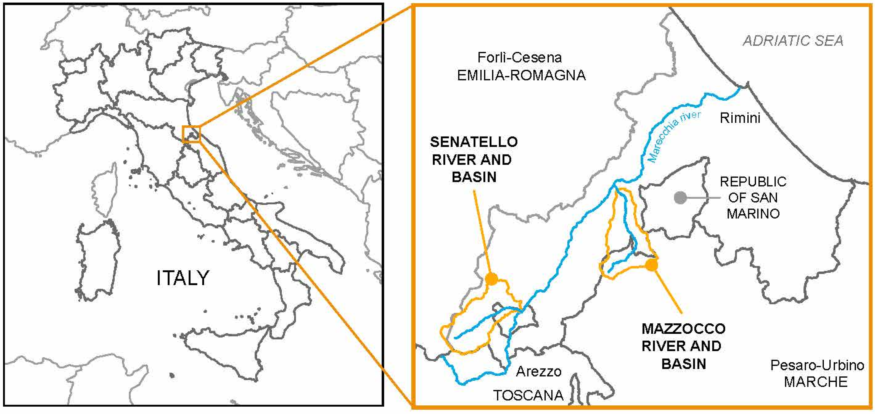
1. Introduction and Study Area

Several methods can be implemented in order to evaluate short-term erosion rates when studying the landscape evolution of mountainous areas in central Italy [1,2,3,4,5], observing a noticeable spatial variability of the “denudation index” (Tu) values.
The present work focuses on two catchment sub-basins of the Marecchia river valley (northern Apennines), Senatello and Mazzocco river basins (48.5 and 46.6 km2, respectively), chosen because of their representativeness of the geological, geomorphological and geodynamic context characterizing the Marecchia river valley.
The short-term erosion rates attributable to fluvial processes are expressed by the mean turbid transport of streams (Tu value; [1,6]); moreover, morphometric analyses have been conducted for both catchment basins, aiming to define several descriptive and quantitative parameters expressing the hierarchization of the river networks, including Tu values.
The Senatello river basin lies at the most western boundary of Emilia-Romagna region and includes a part of the geographic island of Ca’ Raffaello, exclave of Toscana region (Figure 1), extending in the municipalities of Sant’Agata Feltria, Casteldelci (Province of Rimini, Emilia-Romagna), Verghereto (Province of Forlì-Cesena, Emilia-Romagna) and Badia Tedalda (Province of Arezzo, Toscana). The Mazzocco river basin is included in Emilia-Romagna and Marche regions with a small tangent with the boundaries of the Republic of San Marino (Figure 1). In particular, it extends into the municipalities of San Leo, Verucchio, Pennabilli (Province of Rimini, Emilia-Romagna), Monte Grimano Terme, Monte Cerignone and Monte Copiolo (Province of Pesaro-Urbino, Marche).

2. Geological and Geomorphological Settings

The test areas are characterized by extended outcrops of massive allochthonous thrust sheets (known as Valmarecchia Nappe); they consist of Ligurian and Epiligurian Formations that overthrust the Umbro-Marchean autochthonous Units, drawing a peculiar landscape characterized by high geodiversity, and marked above all by differential erosional landforms cut in various formations (Figure 2). The Valmarecchia Nappe has been widely studied in literature due to its complexity and interesting geological features [7,8,9,10,11,12,13,14,15,16,17,18].
The Ligurian and Epiligurian Formations deposited in different sub-basins have been translated through a structural depression, the “Marecchia line” [19], orthogonally to the main Apennine tectonic features. The Ligurian Units, characterized by argillitic clays, are the main responsible for the translating movement of the formations that lay above them, providing a preferential detachment zone to the migration, which occurred during the Miocene Apennine chain uplift. A complex mechanism for the emplacement of the Valmarecchia Nappe is proposed in [20], which includes a tectonic origin due to the Mt. Nero Thrust and a submarine gravitational sliding development within the foredeep basin.
The geological maps (Figure 2) are a representation derived from the combination and homogenization of Emilia-Romagna and Marche regional geological maps at a 1:10,000 scale and the CARG Project [21].
In the Senatello and Mazzocco river valleys, the outcropping formations refer to Ligurian, Epiligurian Units and autochthonous lithotypes, described below with their lithofacies:
-
AQV (Acquaviva Formation), coarse sandstones with pebbles scattered in irregular layers, generally massive and thick and in laterally discontinuous banks. Subordinate are the conglomerate levels, generally lenticular. Lower Tortonian—Messinian;
-
AVR (Argille Varicolori della Valmarecchia Formation): AVRa (Arenaceous lithofacies), AVRb (calcareous-arenaceous lithofacies), chaotic polychromatic clays with intercalated levels of limestone, calcilutites, fine sandstones, siltstones, black clayey marls and marls. Lower Cretaceous—lower Eocene;
-
FMA (Marnoso-Arenacea Romagnola Formation), monotonous succession of turbidite beds with bipartite sandstone-pelite layers and intercalations of marly hemipelagites. Upper Burdigalian—lower Messinian;
-
GHL (Ghioli di Letto Formation), silty-marly clays with thin layers of siltytic sandstones and, in the upper part, bituminous pelites and carbon levels; rare layers of calcilutites and marly limestones. Clayey-marly hemipelagites and slumping levels several meters thick are also present. Tortonian—Messinian;
-
MFU (Monte Fumaiolo Formation), ungraded hybrid sandstones with medium-thin stratification, concave-convex, at times with cross-bedding megaripples, tapering upwards. Upper Burdigalian—Serravallian;
-
MLL (Monte Morello Formation), alternation of limestones and marly limestones, turbidite limestones and marls, and MLLa (Casa Nuova or Marne Rosate lithofacies), marls and marly limestones alternating with dark and polychrome clays. Mid-lower Eocene;
-
SIL (Sillano Formation), alternation of limestones and mudstones, at times polychrome, especially in the basal part, where they become predominant. Locally calcareous marls are present. The carbonate portion is represented by fine-grained turbid limestones, calcilutites and marly limestones. Upper Cretaceous—lower Eocene;
-
SMN (San Marino Formation), organogenic limestones and calcarenites rich in bioclasts. Sometimes, the limestones become silty-sandy and glauconitic, in particular towards the top of the formation. SMN1 (base member), massive biocalcarenites, calcirudites and polygenic conglomerates, sometimes with intercalations of more arenaceous layers with fossil traces, and SMN2 (stratified limestones member), very thick layers of biocalcarenites. Towards the top, the grain size decreases and the non-carbonate component increases, mostly given by glauconitic granules. Upper Burdigalian—lower Langhian;
-
RAA (Villa a Radda Formation), acicular fractured clays alternating with layers of sandstone with carbonatic cement; thin layers of calcisiltites and limestones are rarely present. Upper Cretaceous p.p.—lower Eocene p.p.
Quaternary deposits are represented by alluvial fan and terraced fluvial deposits (braided streams facies) of Ravenna Subsynthem (AES8; upper Pleistocene-Holocene) and Modena Unit (AES8a, Holocene), in addition to recent and current deposits of active landslides (a1), relict landslides (a2), slope debris (a3), flood-colluvial deposits (a4), talus debris (a6), evolving alluvial deposits (b1) and fluvial conoids (i1).
Geomorphological features of both the Mazzocco and Senatello valleys mainly depend on the diverse lithologies and the differential erosional trends of the outcropping formations. In the argillitic formations, such as the Argille Varicolori della Valmarecchia (AVM) or Sillano (SIL) formations, the typical landforms consist of badland areas (Figure 3a), where mudflows and debris-flows mass movements prevail. However, the badlands areas are mostly inactive and very limited if compared to the whole surface of the basins and are concentrated in limited sectors (Senatello: 0.40%; Mazzocco: 4.99%).
In general, an extensive support in shaping present landforms and landscape is due to mass movements of various types (mostly mudslides, debris flows and rotational slides, with additional rock-falls, topplings and lateral expansion).
The areas where Monte Morello (MLL) formation outcrops are often affected by solifluction phenomena, deep-seated gravitational slope deformations and rock-slides (active or relict).
The rhythmic alternation of marls and arenaceous layers induces frequent rock slides and other kind of mass movements within the Marnoso-Arenacea formation (FMA), especially where layers outcrop at a high angle or vertically; the orientation of the strata in the slope direction combined with river erosion produces flatirons. The Contessa bed lies within this formation and is found with a thickness of about 5 m inside the Senatello basin.
Rockfalls and complex landslides characterize the more competent lithotypes, such as the San Marino (SMN), Monte Fumaiolo (MFU) or Acquaviva (AQV) formations, with the development of the main ridges, vertical cliffs and rock pillars (Figure 3b,f). Rockfalls and topplings in those formations have occurred in the past, above all in climate-deterioration periods [22]. Debris at the foot of the cliffs are involved in mudflow like mass movements (Figure 3c), together with the argillitic substrate, thus resulting in complex deposits composed by various size elements in abundant clayey groundmass [23].
The Senatello river valley is narrower, with steeper slopes in comparison to the Mazzocco one; massive blocks can be transported during exceptional floods within the Senatello basin (the average steepness of the longitudinal profiles of the two main rivers is equal to 6.65% for the Senatello river and 6.79% for the Mazzocco river).
The above described recent landforms cannot be completely separated from the geological history of this sector of the northern Apennines. In fact, the Apennines are a young and tectonically active mountain chain, having been uplifted above sea level primarily within the Pliocene [24]. Uplift and the emergence of the Apennines was accompanied by the progressive establishment of a dynamic equilibrium between erosion and deposition rates, also linked to the different climatic phases that have occurred over time [25]. Therefore, erosive and denudation phases of the uplifted Apennine mountains have developed during ancient stationing of the local base levels of erosion. The morphogenesis of soft relief paleo-landscapes and/or erosional planation surfaces has been modelled in discordance mainly on the Eocene, Miocene terrigenous units (Figure 4) and in the Plio-Quaternary clastic deposits.
In the Apennines, the planation surface (PS) by [26] levelled all the topographic contrasts, and it represents a useful marker for deciphering the Plio-Quaternary evolution of landscape and for allowing one to discriminate between pre- and post-planation tectonic activity. Moreover, it represents a key tool to detect neotectonics movements and for assessing seismic hazard also in areas where Plio-Quaternary deposits are not preserved [26].
The presence of small valleys, large and flared, with riverbeds suspended and, more generally, of a sweet landscape with a weak gradient, currently represented by relict and suspended surfaces at different heights, testifies a continental morphogenesis, superimposed on the previous one, and responsible for the obliteration of the older morphological evolution traces.
These surfaces, the extent of which varies from 2000 to 100,000 m squared, with slopes not exceeding 10° and low energy of relief (Figure 5), can be interpreted as polygenic flattening surfaces, re-modelled during erosion cycles, whose plano-altimetric distribution of other generations of relict surfaces (between 1080 m and 240 m asl for the Mazzocco basin and between 1350 and 520 m asl for the Senatello basin), is to be correlated to different local base levels.
The higher surfaces are relicts of larger erosional surfaces of regional extension (S1), while those located at lower altitudes present characteristics that seem to indicate a modelling more similar to the conditions produced by the current hydrographic network. In many cases, where the erosion processes were highly intense and accelerated, the original paleosurface S1 has been reduced to thin ridges or isolated flat peaks (see Figure 3d,e; Mt. San Marco, Mt. Faggiola Nuova or Mt. della Croce).
Quaternary tectonics have strongly influenced the hydrographic network, especially in the Senatello river, as it has controlled the orientation and distribution of some channels of the hydrographic network, qualitatively highlighted by some anomalies of the hydrographic network (straight development, river elbows, high confluences angle, capture phenomena and convergence of river streams, countercurrent tributary branches).
Indications of tectonic influence on the flow of water can be obtained from the calculation of morphometric parameters that quantitatively describe the organization of the hydrographic network [1,6]. The trends of the minor waterways (1st and 2nd order in Strahler’s hierarchy [27], identified at a 1:25,000 scale and compared to aerial pictures) generally show a good correspondence with the families of faults and fractures that pervade the rocky bodies more widely.

3. Materials and Methods

The data reported in this paper have been collected through field surveys, supported by multi-temporal analysis of aerial photos and bibliographical research. The geological maps have been drawn starting from Emilia–Romagna SGSS (Geological, Seismic and Soil Survey) and Marche region geological cartographies. The calculations are built on river network geometry and erosional paleo-surfaces distributions, from which estimations of short and long-term erosion rates can be derived.

Geomorphic Analysis and Short-Term Erosion Rates Calculation

In order to evaluate short-term erosion rates in the Senatello and Mazzocco river basins, quantitative geomorphic analyses have been conducted following the classical geomorphological approach (Horton, 1945; Strahler, 1957), widened by Italian authors [1,6]. The stream networks, digitalized and geo-referenced in ArcGIS environment by comparing aerial images and IGM Topographic Map of Italy (scale 1:25,000), have been hierarchized following Strahler [27] at 1:25,000 scale. The morphometric parameters obtained with the analyses are representative of the geometry and development of the drainage basins, and are expression of the erosion, transport and sedimentation processes attributable to river dynamics [28,29]. Such analyses have been conducted on the assumption that climate conditions have remained roughly constant throughout the latter half of the Holocene [30].
The geomorphic parameters obtained from network analyses and supporting GIS calculations are:
-
Nu = number of river channels of u order [31];
-
Ndu = number of river channels of u order that merge into river channels of u + 1 order;
-
A = area of the basin (km2);
-
∑L = total sum of river channel lengths (km);
-
D = drainage density = ∑L/A (km/km2) [32];
-
L = main channel length (km);
-
Rf = shape factor = A/L2;
-
Rc = circularity ratio = 4πA/P2 [33];
-
Ru = uniformity index or compactness coefficient = 0.2841 × P/A0.5 [34];
-
Ra = elongation ratio = 2/Lb × (A/π)0.5 [35];
-
S = sinuosity index = D/(Nu/A);
-
P = perimeter of the basin (km);
-
F1 = first order channels frequency = N1/A;
-
Rb = bifurcation ratio = Nu/Nu+1;
-
Rbd = direct bifurcation ratio = Ndu/Nu+1;
-
R = bifurcation index, R = Rb − Rbd;
-
Ga = hierarchical anomaly number, the smallest number of first order streams necessary to make the drainage net perfectly conservative [36]; Ga = s 2 i = 1 s r = i + 2 N i , r × f i , r ;
-
Δa = hierarchical anomaly index = Ga/N1;
-
ga = hierarchical anomaly density = Ga/A.
The estimation of the drainage network extension and organization degree led to the evaluation of denudation power within drainage basins. To this end, some relations were used which allow to one calculate the denudation rate index, expressed by the suspended sediment yield (Tu, t/km2/year) that was computed as a function of the morphometric parameters determined by [1] using the equations:
log Tu = 1.82818 log D + 0.01769 ga + 1.53034
The Turbidity Unit Index of Tu Index is a set of equations with high determination coefficients derived by [2], through a statistical correlation of measured suspended sediment yield data at the outlets of 20 gauged Italian watersheds with selected geomorphic and climatic parameters.
Tu values directly express the specific effect of linear erosion processes (recent or present) inside the drainage basin, and give information about the erodibility of outcropping rocks. Moreover, Tu is independent from the catchment area, and it can be used to compare different drainage basins [37].
The Tu value has then been converted in denudation height or erosion rate (Ta expressed in mm/year), considering the average density of outcropping rocks of sample areas according to the following expression:
Ta = Tu/γs × 10−3
where Tu is the suspended sediment yield and γs is the specific weight of the drained rocks. The value of γs, determined by the simple average of the values assigned to the single geological formations in the two basins (Table 1), that are comparable to each other, is equal to 2.5 gr/cm3.
Finally, the DEM used is freely available as a 10 m-cell size grid (in GeoTIFF format), in the UTM WGS84 zone 32 projection system [38].

4. Results

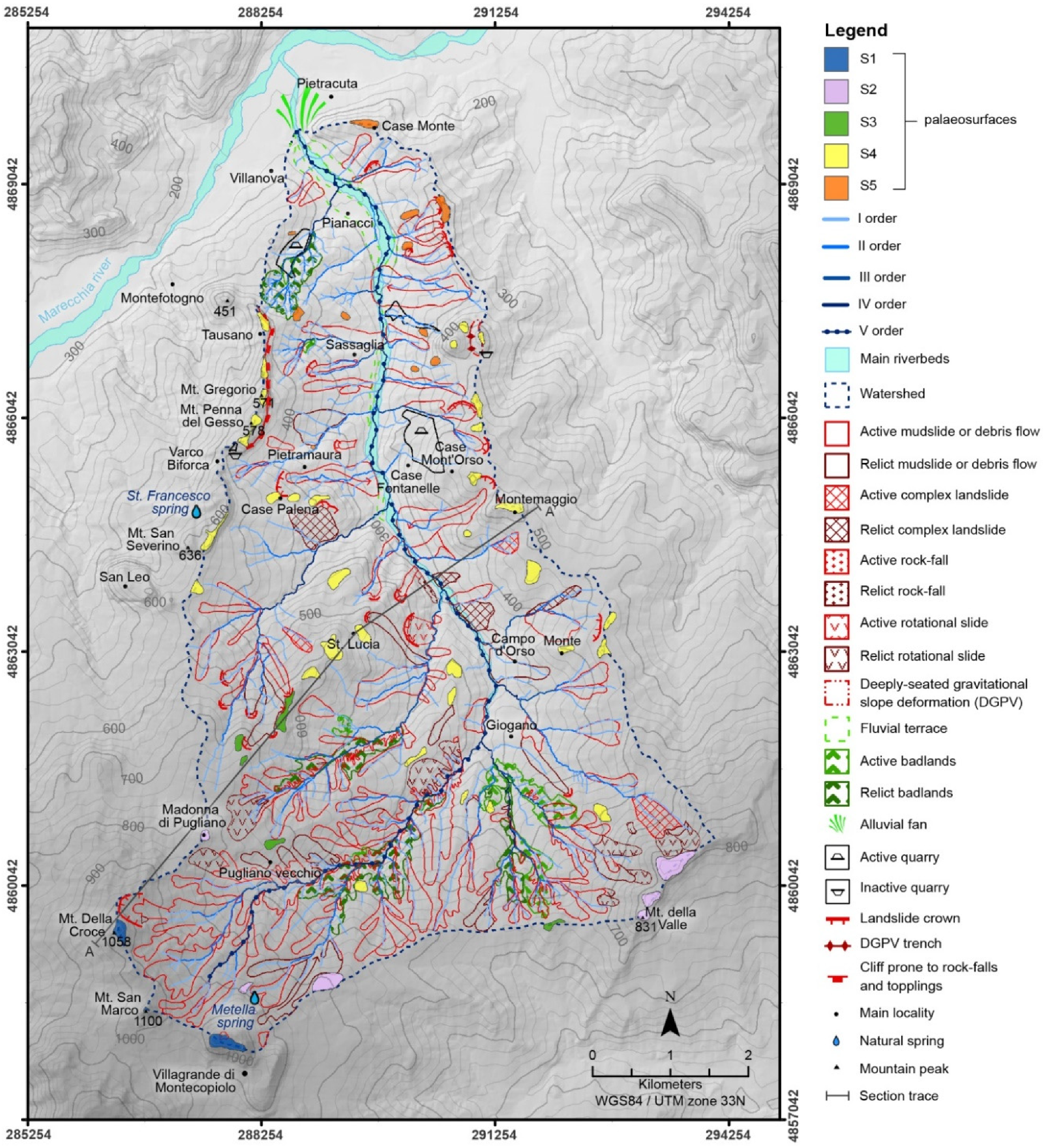
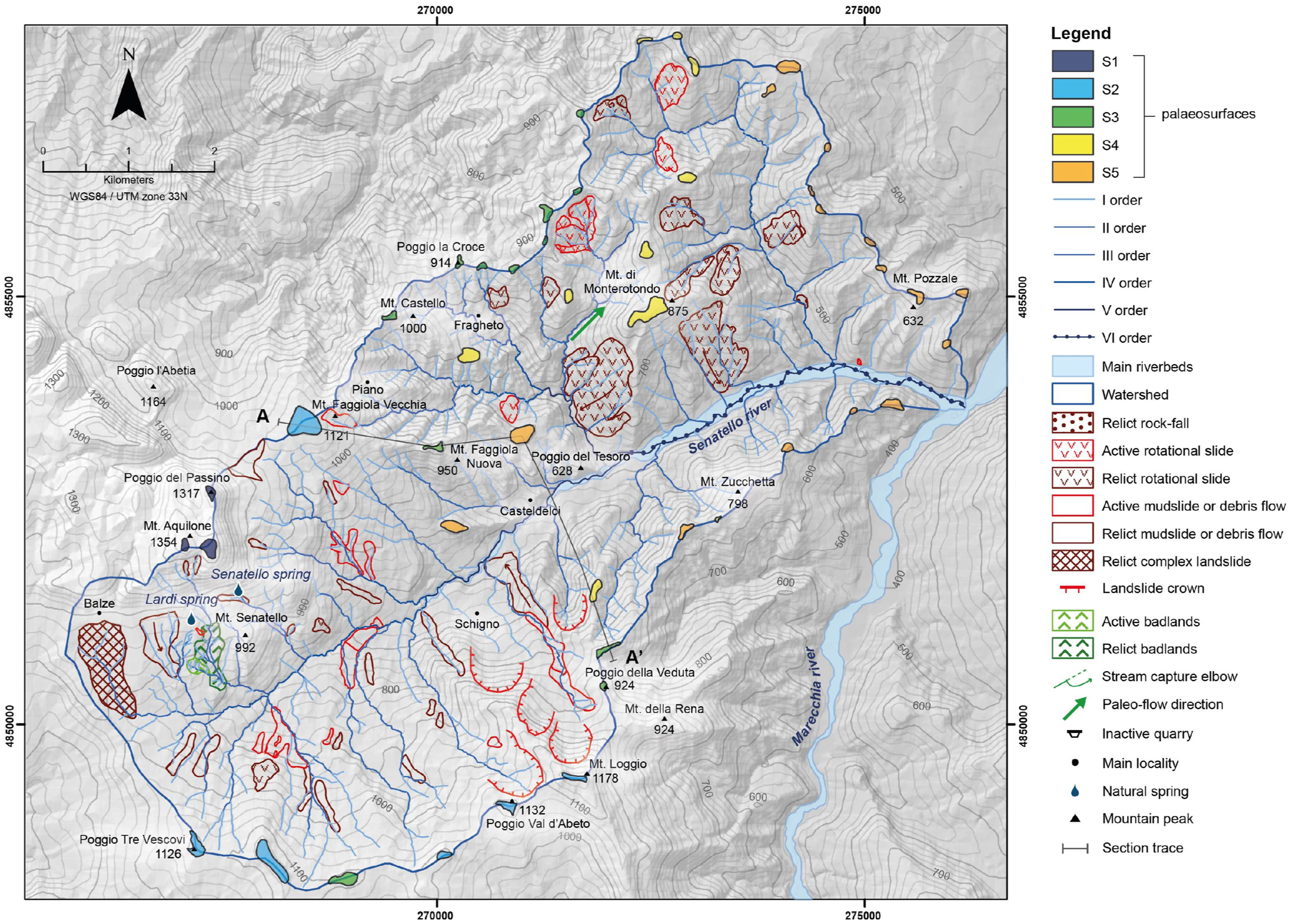
4.1. Geomorphological Maps

The first results derived from the field survey are the geomorphological maps, which outline the main geomorphological features and reconstruct the main morpho-evolutive phases of the two studied basins (Figure 6 and Figure 7), including mass movements (active o relict), ancient landslide detachment areas, badlands, five orders of ancient surfaces (remnants of paleotopography), expressing the different stages in the morphological evolution of the valley, alluvial fans, hierarchized hydrographic networks and springs. The surface remnants distribution along the river profiles and in relation to the section traces drawn in the maps have been defined in field and by means of a slope map (Figure 5), calculated using the DEM [38], and graphically represented in Figure 8 and Figure 9.
Typical landforms on clayey slopes are represented by “calanchi” or badlands (active o relict). The clay bedrock plays a key role in badlands development, along with stratification and cap-rocks.
Mass movements contribute to slope denudation, together with surface running waters. Apart from some rock falls, several, sometimes large, rotational slides were detected on steep slopes (Figure 6 and Figure 7). Nevertheless, the influence of gravity is evident also on gentler slopes, where mudflows are widespread. Due to these processes, gentle slopes show a typical concave-convex shape, which extends for hundreds of meters. On these slopes, frequently reworked by human activity, ephemeral gullies are also recognizable, which rapidly grow as a consequence of concentrated rainfalls and extreme events [39,40].
Particular attention has also been addressed to the anthropic forms present in the study areas, as the quarry sites, active or abandoned [41]; in the mountainous part of the Marecchia river valley, in fact, numerous rock excavation sites existed until the recent past, and those activities have been extensively performed throughout history, modifying these specific sectors of the landscape.

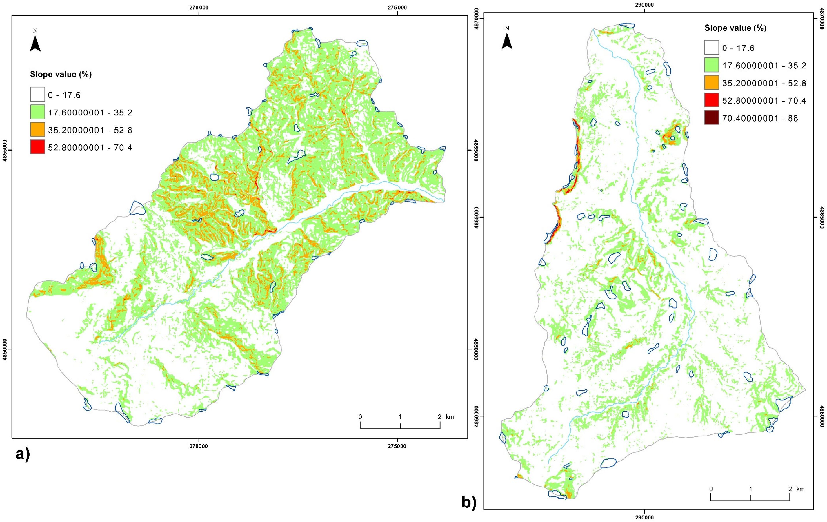
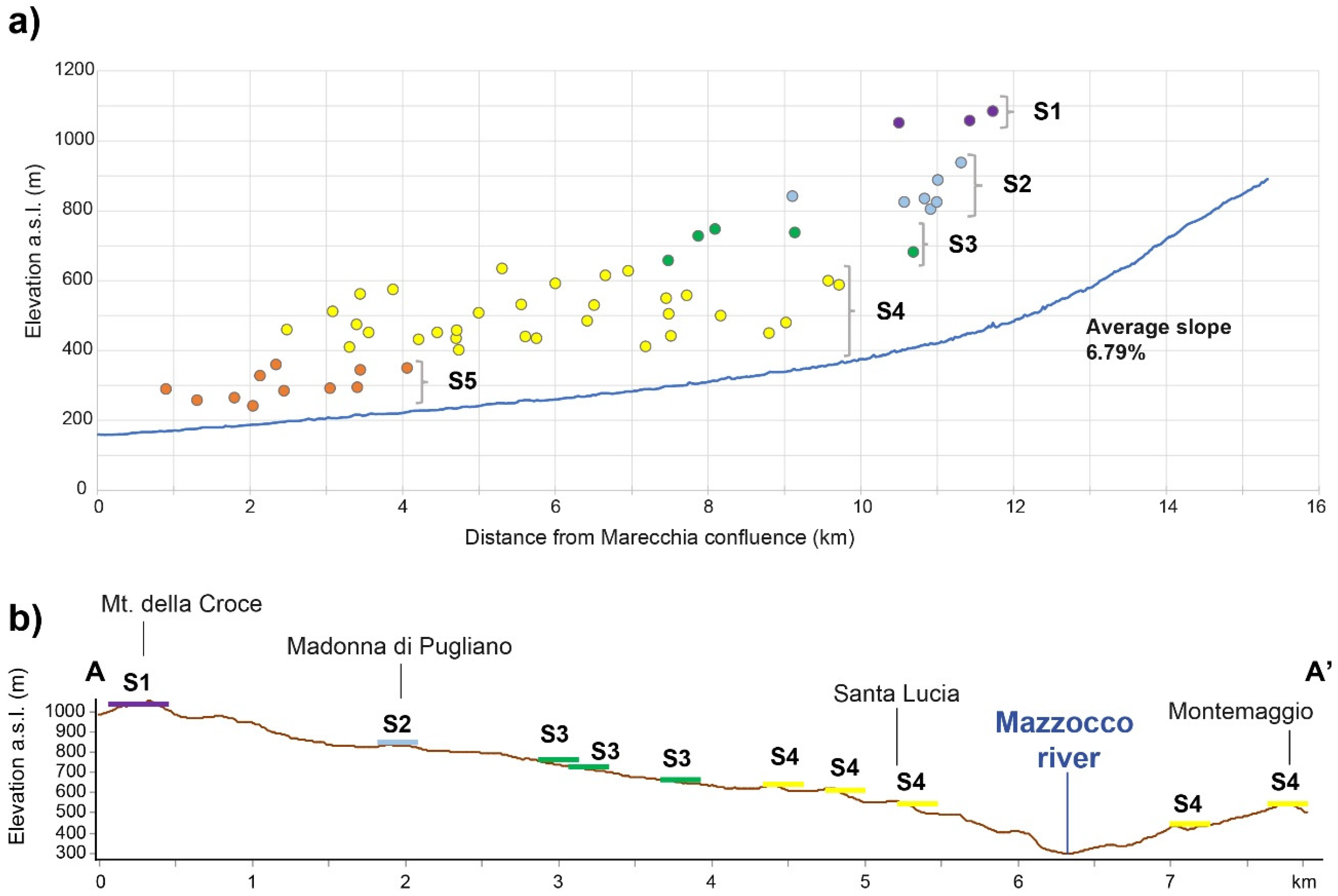
4.2. Geomorphic Analysis and Short-Term Erosion Rates

Quantitative geomorphic analysis was performed with the dual purpose of stating quantitatively the efficacy of the morphogenetic processes and assessing the short-time erosion rate. This analysis was based on the morphometric study of the drainage network, which allowed one to calculate several significant parameters (Table 2 and Table 3).
In general, quite similar values result from the quantitative analyses of Senatello and Mazzocco river networks. The most meaningful geomorphic parameters are those that are an expression of the state of morpho-tectonic maturity of the basin, such as the bifurcation index and ratio (Rb, Rbd, R), representing the state of hierarchical organization of the network; in our case, values are greater in the Mazzocco basin. Elongation and circularity ratios (Rf and Rc) depend on the evolutionary stage of the geomorphological features and describe the geometry of the basin (see Table 4).
Parameters such as drainage density (D) and hierarchical anomaly index (Δa) are representative of drainage network features that strongly affect denudation intensity [36,37,38,39].
The Senatello river hydrographic network has an order of 6 (sensu Strahler [27]) and has a drainage density value of 3.85 [1,6], whilst the Mazzocco has an order of 5 and a drainage density value of 3.66; both values are compatible with a prevalent clayey-marly substrate on the entire basin surfaces. According to the classification given by [42], the drainage density can be classified as “coarse” falling in low-density category.
Values greater than 3 of the bifurcation ratio (Rb) indicate a somewhat disorganized hydrographic network geometry, typical of the areas controlled by tectonics and characterized by lithological heterogeneity.
However, the considerations about the hierarchy degree of the hydrographic network, deductible from the bifurcation ratio, must be verified; in fact, this parameter takes into account only the total number of segments in the different orders, and does not always provide univocal indications [6]. The structure and organization of the fluvial network can therefore be better investigated through the direct bifurcation ratio (Rbd), as this parameter is influenced by the relationships between the confluent fluvial segments. The index provides indications on the average structure of the anomalous portion (segments of order u that do not flow into segments of order u + 1) and assumes values close to zero in cases of poor tectonic activity (well hierarchical hydrographic network with segments of order u that regularly flow into those of an immediately higher order), while it approaches or exceeds values of 2 for a network totally influenced by the deformation pattern.
The information deductible from the bifurcation index can be integrated from that obtained from the number, the index and the density of hierarchical anomaly that are most suitable for comparison between different river basins, as in the case study.
The Δa values greater than 1 suggest a possible structural control on the drainage networks, while the ga values (<10) indicate moderate slope processes, and confirm that most of the hierarchically anomalous influences are due to 1st and 2nd order streams, which flow into the main waterways (Table 2 and Table 3). Such a configuration is certainly linked to a control by the tectonics on the organization of the drainage network.
Denudation rates have been indirectly calculated in terms of mean annual suspended sediment yield (Tu, [1]). Previous works demonstrated that the indirect estimation of mean annual suspended sediment yield (Tu) obtained by geomorphic approach are consistent with short-term denudation rates estimated by reservoir sedimentation and field monitoring data of erosion [5,43].
The studied drainage basins showed a limited range of denudation rate index (Tu) values, between about 509 and 562 t/km2/year (Table 4).
Starting from the Tu values, the denudation height or erosion rate (Ta) has been calculated, considering the average density of outcropping rocks of sample areas according the expression (2), obtaining very similar erosion rates for the two river basins, respectively, 0.20 mm/year for Mazzocco and 0.22 mm/year for Senatello (Table 4).

5. Discussion and Final Remarks

Erosion, incision, and uplift have existed since the middle Pleistocene along the Apennine chain conditioning fluvial dynamics and relative erosional and depositional rate. In order to estimate river erosion rates with empirical or semi-empirical methods, many authors have used simple relationships based on quantitative geomorphic analysis methods. In particular, the application of the Tu index model in the case studies confirms the suitable performance of this approach to predict sediment yield.
The method used provided values of Tu for the two intermountain basins comparable with those calculated on other northern and central Apennine basins, with drainage density values in the range 3.6–3.9 [43,44].
However, owing to its simple structure, the applied Equation (1) does not directly consider any factor influencing soil erosion processes in the uplands (for instance, land use, soil erodibility, rainfall erosivity, slope steepness and length). Consequently, the outcomes of the equation cannot be directly linked to accelerated soil erosion due to short-term anthropogenic impact. Being based on geomorphologic parameters, this indirect method reasonably expresses the medium-time-scale response of the drainage network to disequilibrium conditions induced by quaternary climate oscillation and uplift [43]. However, authors in [45] suggest that the Tu index can be considered a suitable tool for estimating the medium-to-long-term denudation rate in drainage basins characterized by fluvial processes largely acting in terrigenous deposits, as the case studies.
Starting from the Tu value, the erosion rate was calculated using an average value of γs equal to 2.5 gr/cm3. The erosion rates calculated for the two intermountain fluvial catchments (Ta) are comparable with the erosion rates in the Apennines estimated by [25] in a variable range from 0.20 to 0.58 mm/year, from middle Pleistocene (0.9 Myear) to present day.
Authors in [46,47] agree that these rates are insufficient to maintain the Apennine in a steady state, although the latter is testified by the presence of V orders of erosional surfaces distributed at different altitudes (Figure 8 and Figure 9); the chain uplift is also expressed by the extensive outcrops of marly formations prone to erosion, such as the Marnoso-Arenacea Fm., that are found at high elevation and relief energy levels.
Moreover, the comparison of these short-term mean data with the uplift rates calculated on a regional scale (0.41 ± 0.26 mm/year) in the Marecchia valley [25], confirms that the northern Apennines may represent a non-steady state system.

Author Contributions

Conceptualization, M.L., V.G.; methodology, M.L.; geomorphological analysis and field survey M.L. and V.G.; formal analysis, V.G.; data curation, V.G., writing—original draft preparation, M.L., V.G.; writing—review and editing, M.L., V.G.; supervision, M.L.; funding acquisition V.G. All authors have read and agreed to the published version of the manuscript.

Funding

This research received no external funding. The work was conducted as part of Veronica Guerra’s Ph.D. in progress at the University of Urbino “Carlo Bo”.

Acknowledgments

We kindly thank Emilia-Romagna Region, Marche Region, Rimini SITUA for directly or openly providing useful data. We are very grateful to Anna Bonavita, native English speaker, for linguistic and grammatical English editing.

Conflicts of Interest

The authors declare no conflict of interest.

References

  1. Ciccacci, S.; Fredi, P.; Palmieri, E.L.; Pugliese, F. Contributo dell’analisi geomorfica quantitativa alla valutazione dell’entità dell’erosione nei bacini fluviali. Boll. Soc. Geol. It. 1980, 99, 455–516. [Google Scholar]
  2. Ciccacci, S.; Fredi, P.; Palmieri, E.L.; Pugliese, F. Indirect evaluation of erosion entity in drainage basins through geomorphic, climatic and hydrological parameters. Int. Geomorphol. 1986, 2, 33–48. [Google Scholar]
  3. Del Monte, M.; Fredi, P.; Palmieri, E.L.; Marini, R. Contribution of quantitative geomorphic analysis to the evaluation of geomorphological hazards. In Applied Geomorphology: Theory and Practice; Allison, R.J., Ed.; J. Wiley & Sons: Hoboken, NJ, USA, 2002; pp. 335–358. [Google Scholar]
  4. Del Monte, M. Caratteristiche morfometriche e morfodinamiche dell’alto bacino del Fiume Orcia (Toscana meridionale). Congr. Geogr. It. 2003, Atti XXVIII, 1938–1975. [Google Scholar]
  5. Della Seta, M.; Del Monte, M.; Fredi, P.; Palmieri, E.L. Direct and indirect evaluation of denudation rates in Central Italy. Catena 2007, 71, 21–30. [Google Scholar] [CrossRef]
  6. Avena, G.C.; Giuliano, G.; Palmieri, E.L. Sulla valutazione quantitativa della gerarchizzazione ed evoluzione dei reticoli fluviali. Boll. Soc. Geol. It. 1967, 86, 781–796. [Google Scholar]
  7. Bonarelli, G. Interpretazione strutturale della regione feltresca. Boll. Soc. Geol. It. 1929, 48, 314–316. [Google Scholar]
  8. Capozzi, R.; Landuzzi, A.; Negri, A.; Vai, G. Stili deformativi ed evoluzione tettonica della successione neogenica romagnola. Stud. Geol. Camer. 1991, 1, 261–278. [Google Scholar]
  9. Cerrina Feroni, A.; Ghiselli, F.; Leoni, L.; Martelli, L.; Martinelli, P.; Ottria, G.; Sarti, G. L’assenza delle Liguridi nell’Appennino romagnolo: Relazioni tra il sollevamento quaternario e implicazioni strutturali. Quaternario 1997, 10, 371–376. [Google Scholar]
  10. Cerrina Feroni, A.; Ottria, G.; Martinelli, P.; Martelli, L. Carta Geologico-Strutturale dell’Appennino Emiliano-Romagnolo. Scala 1:250.000, Regione Emilia-Romagna; Consiglio Nazionale delle Ricerche: Bologna, Italy, 2002. [Google Scholar]
  11. Conti, S.; Fregni, P.; Gelmin, R. L’età della messa in posto della coltre della Val Marecchia. Implicazioni paleogeografiche e strutturali. Mem. Soc. Geol. It. 1987, 39, 143–164. [Google Scholar]
  12. Ricci Lucchi, F. The Oligocene to recent foreland basins of the northern Apennines. In International Association of Sedimentologists Special Publications; Allen, P.A., Homewood, P., Eds.; Blackwell Scientific Publications: Oxford, UK, 1986; Volume 8, pp. 105–139. [Google Scholar]
  13. Selli, R. Il bacino del Metauro. Descrizione geologica, risorse minerarie, idrogeologia. Giornal. Geol. 1954, 24, 1–214. [Google Scholar]
  14. Vai, G.; Castellarin, A. Correlazione sinottica delle unità stratigrafiche nell’Appennino settentrionale. Stud. Geol. Camer. 1992, Spec. Vol. 1992/2, 171–185. [Google Scholar]
  15. Zattin, M.; Picotti, V.; Zuffa, G.G. Fission-track reconstruction of the front of the northern Apennine thrust wedge and overlying Ligurian unit. Am. J. Sci. 2002, 302, 346–379. [Google Scholar] [CrossRef]
  16. Carmignani, L.; Conti, P.; Cornamusini, G.; Meccheri, M. The internal Northern Apennines, the Northern Tyrrhenian Sea and the Sardinia-Corsica Block. In Geology of Italy. Special Volume of the Italian Geological Society for the IGC Florence; Crescenti, S.U., D’Offizi, S., Merlino Sacchi, L., Eds.; Società Geologica Italiana, Roma: Rome, Italy, 2004; pp. 59–77. [Google Scholar]
  17. Carmignani, L.; Conti, P.; Cornamusini, G.; Pirro, A. Geological map of Tuscany (Italy). J. Maps 2013, 9, 487–497. [Google Scholar] [CrossRef]
  18. Cornamusini, G.; Ielpi, A.; Bonciani, F.; Callegari, I.; Conti, P. Geological map of the Chianti Mts (Northern Apennines, Italy). J. Maps 2012, 8, 22–32. [Google Scholar] [CrossRef] [Green Version]
  19. Conti, S. Geologia dell’Appennino marchigiano-romagnolo tra le valli del Savio e del Foglia. Note illustrative alla carta geologica a scala 1:50,000. Boll. Soc. Geol. It. 1989, 108, 453–490. [Google Scholar]
  20. Cornamusini, G.; Conti, P.; Bonciani, F.; Callegari, I.; Martelli, L. Geology of the ‘Coltre della Val Marecchia’ (Romagna-Marche Northern Apennines, Italy). J. Maps 2017, 13, 207–218. [Google Scholar] [CrossRef] [Green Version]
  21. Cornamusini, G.; Martelli, L.; Conti, P.; Pieruccini, P.; Benini, A.; Bonciani, F.; Carmignani, L. Note Illustrative Della Carta Geologica d’Italia alla Scala 1: 50.000; Foglio 266-Mercato Saraceno; Servizio Geologico d’Italia: Roma, Italy, 2009; p. 124. [Google Scholar]
  22. Guerra, C.; Nesci, O. L’analisi del paesaggio storico come strumento per la comprensione dell’evoluzione geomorfologica e ambientale del territorio. Alcuni casi studio nel Montefeltro. Geol. Emilia Romagna 2012, 48–49, 7–16. [Google Scholar]
  23. Casagli, N. Meccanismi di Instabilità Indotti dal Contrasto di Competenza in Ammassi Rocciosi su un Substrato Deformabile. Ph.D. Thesis, University of Milan, Milan, Italy, 1994. [Google Scholar]
  24. Lucchi, F. Turbidites on foreland and on-thrust basins of the northern Apennines. Palaeogeogr. Palaeoclimatol. Palaeoecol. 1990, 77, 51–66. [Google Scholar] [CrossRef]
  25. Cyr, A.J.; Granger, D.E. Dynamic equilibrium among erosion, river incision, and coastal uplift in the northern and central Apennines, Italy. Geology 2008, 36, 103–106. [Google Scholar] [CrossRef]
  26. Coltorti, M.; Pieruccini, P. A late Lower Pliocene planation surface across the Italian Peninsula: A key tool in neotectonic studies. J. Geodyn. 2000, 29, 323–328. [Google Scholar] [CrossRef]
  27. Strahler, A.N. Quantitative analysis of watershed geomorphology. Trans. Am. Geoph. Un. 1957, 38, 913–920. [Google Scholar] [CrossRef] [Green Version]
  28. Lazzari, M.; Schiattarella, M. Confronto tra tassi di erosione fluviale e da franosità in alta Val d’Agri (Appennino meridionale). In Studi di Base Sull’Interazione tra Clima, Tettonica e Morfoevoluzione in Italia Meridionale Durante il Quaternario; Boenzi, F., Capolongo, D., Giano, S.I., Schiattarella, M., Eds.; Dibuono Edizioni, Villa d’Agri (PZ): Marsicovetere, Italy, 2008; pp. 105–114. [Google Scholar]
  29. Lazzari, M.; Schiattarella, M. Estimating long to short-term erosion rates of fluvial vs mass movement processes: An example from the axial zone of the southern Italian Apennines. It. J. Agron. 2010, 5, 57–66. [Google Scholar] [CrossRef] [Green Version]
  30. Schiattarella, M.; Beneduce, P.; Pascale, S. Comparazione tra i tassi di erosione e sollevamento dell’Appennino Lucano: L’esempio della Fiumara di Tito e Picerno. Boll. A.I.C. 2004, 121–122, 367–385. [Google Scholar]
  31. Horton, R.E. Erosional development of streams and their drainage basins; hydrophysical approach to quantitative morphology. Geol. Soc. Am. Bull. 1945, 56, 275–370. [Google Scholar] [CrossRef] [Green Version]
  32. Horton, R.E. Drainage Basin Characteristics. Trans. Am. Geophys. Union 1932, 13, 350–361. [Google Scholar] [CrossRef]
  33. Miller, V.C. A quantitative geomorphic study of drainage basin characteristics in the clinch mountain area. In Technical Report 3; Department of Geology, Columbia University: New York, NY, USA, 1953. [Google Scholar]
  34. Gravelius, H. Grundriß der gesamten Gewasserkunde, Band 1: Flußkunde. Compend. Hydrol. 1914, I, 265–278. [Google Scholar]
  35. Schumm, S.A. Evolution of Drainage Systems & Slopes in Badlands at Perth Anboy, New Jersey. Bull. Geol. Soc. Am. 1956, 67, 597–646. [Google Scholar] [CrossRef]
  36. Melton, M.A. An Analysis of the Relation among Elements of Climate, Surface Properties, and Geomorphology; Department of Geology, Columbia University: New York, NY, USA, 1957. [Google Scholar] [CrossRef]
  37. Ciccacci, S.; Fredi, P.; Lupia Palmieri, E. Quantitative expression of climatic and geomorphic factors affecting erosional processes: Indirect determination of the amount of erosion in drainage basins in Italy. An approach. In Proceedings of the Polish-Italian Seminar “Superficial Mass Movement in Mountain Regions”, Warszawa, Poland, 17–19 May 1979; pp. 76–89. [Google Scholar]
  38. Tarquini, S.; Isola, I.; Favalli, M.; Mazzarini, F.; Bisson, M.; Pareschi, M.T.; Boschi, E. TINITALY/01: A new triangular irregular network of Italy. Ann. Geophys. 2007, 50, 407–425. [Google Scholar]
  39. Zingaro, M.; Refice, A.; Giachetta, E.; D’Addabbo, A.; Lovergine, F.; De Pasquale, V.; Pepe, G.; Brandolini, P.; Cevasco, A.; Capolongo, D. Sediment mobility and connectivity in a catchment: A new mapping approach. Sci. Total Environ. 2019, 672, 763–775. [Google Scholar] [CrossRef]
  40. Brandolini, P.; Pepe, G.; Capolongo, D.; Cappadonia, C.; Cevasco, A.; Conoscenti, C.; Marsico, A.; Vergari, F.; Del Monte, M. Hillslope degradation in representative Italian areas: Just soil erosion risk or opportunity for development? Land Degrad. Dev. 2018, 29, 3050–3068. [Google Scholar] [CrossRef]
  41. Brandolini, P.; Cappadonia, C.; Luberti, G.M.; Donadio, C.; Stamatopoulos, L.; Di Maggio, C.; Faccini, F.; Stanislao, C.; Vergari, F.; Paliaga, G.; et al. Geomorphology of the Anthropocene in Mediterranean urban areas. Progr. Phys. Geogr. 2020, 44, 461–494. [Google Scholar] [CrossRef]
  42. Smith, K.G. Standards for grading textures of erosional topography. Am. J. Sci. 1950, 248, 655–668. [Google Scholar] [CrossRef]
  43. Della Seta, M.; Del Monte, M.; Fredi, P.; Palmieri, E.L. Space–time variability of denudation rates at the catchment and hillslope scales on the Tyrrhenian side of Central Italy. Geomorphology 2009, 107, 161–177. [Google Scholar] [CrossRef]
  44. Ciccacci, S.; D’Alessandro, L.; Fredi, P.; Lupia Palmieri, E. Contributo dell’analisi geomorfica quantitativa allo studio dei processi di denudazione nel bacino idrografico del Torrente Paglia (Toscana meridionale–Lazio settentrionale). Geogr. Fis. Din. Quat. 1988, 1, 171–188. [Google Scholar]
  45. Gioia, D.; Martino, C.; Schiattarella, M. Long- to short-term denudation rates in the southern Apennines: Geomorphological markers and chronological constraints. Geol. Carpath. 2011, 62, 27–41. [Google Scholar] [CrossRef]
  46. Bartolini, C. An overview of Pliocene to present-day uplift and denudation rates in the Northern Apennine. Geol. Soc. London Spec. Publ. 1999, 162, 119–125. [Google Scholar] [CrossRef]
  47. Amato, A.; Aucelli, P.P.C.; Cinque, A. The long-term denudation rate in the Southern Apennines Chain (Italy): A GIS-aided estimation of the rock volumes eroded since middle Pleistocene time. Quat. Int. 2003, 101, 3–11. [Google Scholar] [CrossRef]
Figure 1. Location map of Mazzocco and Senatello river basins.
Water 12 02535 g001
Figure 2. Geological maps of Senatello and Mazzocco river valleys.
Water 12 02535 g002
Figure 3. Some examples of landforms and geomorphological processes in the two analyzed river basins. Legend: (a) Badlands and shallow landslides near St. Lucia (Mazzocco valley); (b) Mt. Penna del Gesso (Mazzocco valley); (c) debris-flow near Casteldelci (Senatello Valley) and flow direction in red; (d) S1 paleosurface of Mt. Montone (Mazzocco valley); (e) S2 and S3 paleosurfaces of Mt. Faggiola Vecchia and St. Maria in Sasseto (Senatello valley); (f) Casteldelci cliff and Senatello riverbed (Senatello valley).
Water 12 02535 g003
Figure 4. Example of sub-flat (S5; red dashed line) and discordant erosion surface on the vertical calcarenites of the San Marino formation—Basic member (middle Eocene—upper Miocene). The outcrop is located at an abandoned quarry in Mt. Ceti (black dotted line indicates the missing volume of the original surface, quarried for construction use).
Water 12 02535 g004
Figure 5. Slope maps of Senatello (a) and Mazzocco (b) river valleys with evidence of sub-flat erosion surfaces (blue polygons).
Water 12 02535 g005
Figure 6. Geomorphological map of Mazzocco river valley.
Water 12 02535 g006
Figure 7. Geomorphological map of Senatello river valley.
Water 12 02535 g007
Figure 8. Altimetric distribution of ancient erosional surfaces (Mazzocco river basin); (a): distribution along the longitudinal profile; (b): distribution along section trace A-A’.
Water 12 02535 g008
Figure 9. Altimetric distribution of ancient erosional surfaces (Senatello river basin); (a): distribution along the longitudinal profile; (b): distribution along section trace A-A’.
Water 12 02535 g009
Table 1. Summary table of the γs values and descriptions of the geological formations of the Mazzocco and Senatello river basins.
Geological FormationAbbr.Lythotypeγs gr/cm3
Acquaviva FormationAQVCoarse sandstones with pebbles. Subordinate are the conglomerate levels, generally lenticular.2.4
Argille Varicolori FormationAVRChaotic polychromatic clays with intercalated levels of limestone, calcilutites, fine sandstones, siltstones, black clayey marls and marls.2.3
Marnoso-Arenacea FormationFMATurbidite sandstone-pelite layers and intercalations of marly hemipelagites.2.7
Ghioli di letto FormationGHLSilty-marly clays with thin layers of siltytic sandstones and, in the upper part, bituminous mudstones and carbon levels.2.3
Monte Fumaiolo FormationMFUUngraded hybrid sandstones with medium-thin stratification.2.7
Monte Morello FormationMLLAlternation of limestones and marly limestones, turbidite limestones and marls.2.7
Monte Morello Formation—Case Nuove or Marne Rosate lithofaciesMLLaMarls and marly limestones alternating with dark and polychrome clays.2.4
Sillano FormationSILAlternation of limestones and mudstones. Locally calcareous marls are present.2.4
San Marino FormationSMNOrganogenic limestones and calcarenites rich in bioclasts.2.7
San Marino Formation—base MemberSMN1Massive biocalcarenites, calcirudites and polygenic conglomerates, sometimes with intercalations of more arenaceous layers.2.5
San Marino Formation—stratified limestones MemberSMN2Very thick layers of biocalcarenites.2.4
Villa a Radda FormationRAAClays alternating with layers of sandstone with carbonatic cement.2.4
Table 2. Nu, Ndu and Rb values counts for Mazzocco and Senatello river basins.
MazzoccoNuNduRbSenatelloNuNduRb
1st order323241 1st order334256
4.31 4.02
2nd7547 2nd8356
3.95 4.37
3rd1914 3rd1915
3.17 3.80
4th66 4th54
6 2.50
5th1 5th22
6th1
Total424398 Total443333
Mean value 4.36Mean value 3.67
Table 3. Anomalies number and anomalous frequencies of Mazzocco and Senatello river basins.
MazzoccoAnomalies NumberAnomalous Frequences
N 1–3N 1–4N 1–5 F 1–3F 1–4F 1–5
323019 3290133
N 2–4N 2–5 F 2–4F 2–5
1413 2878
N 3–5 F 3–5
5 20
SenatelloAnomalies NumberAnomalous Frequences
N 1–3N 1–4N 1–5N 1–6F 1–3F 1–4F 1–5F 1–6
441837445421105
N 2–4N 2–5N 2–6 F 2–4F 2–5F 2–6
1186 224884
N 3–5N 3–6 F 3–5F 3–6
22 816
N 4–6 F 4–6
1 8
Table 4. Geomorphic quantitative parameters in Mazzocco and Senatello river basins.
BasinsNuNduA∑LDLRfRcRuRaS
Mazzocco42430846.61713.6713.60.250.501.430.570.40
Senatello44433148.5186.93.8511.20.390.621.430.700.42
PF1RbRbdRGaΔagalog TuTuTa
Mazzocco34.56.934.363.510.853811.188.182.71509.750.20
Senatello35.36.893.672.760.924101.238.452.75562.530.22

