Sustainable Development of Arid Rangelands and Managing Rainwater in Gullies, Central Asia


Abstract
1. Introduction
2. Materials and Methods
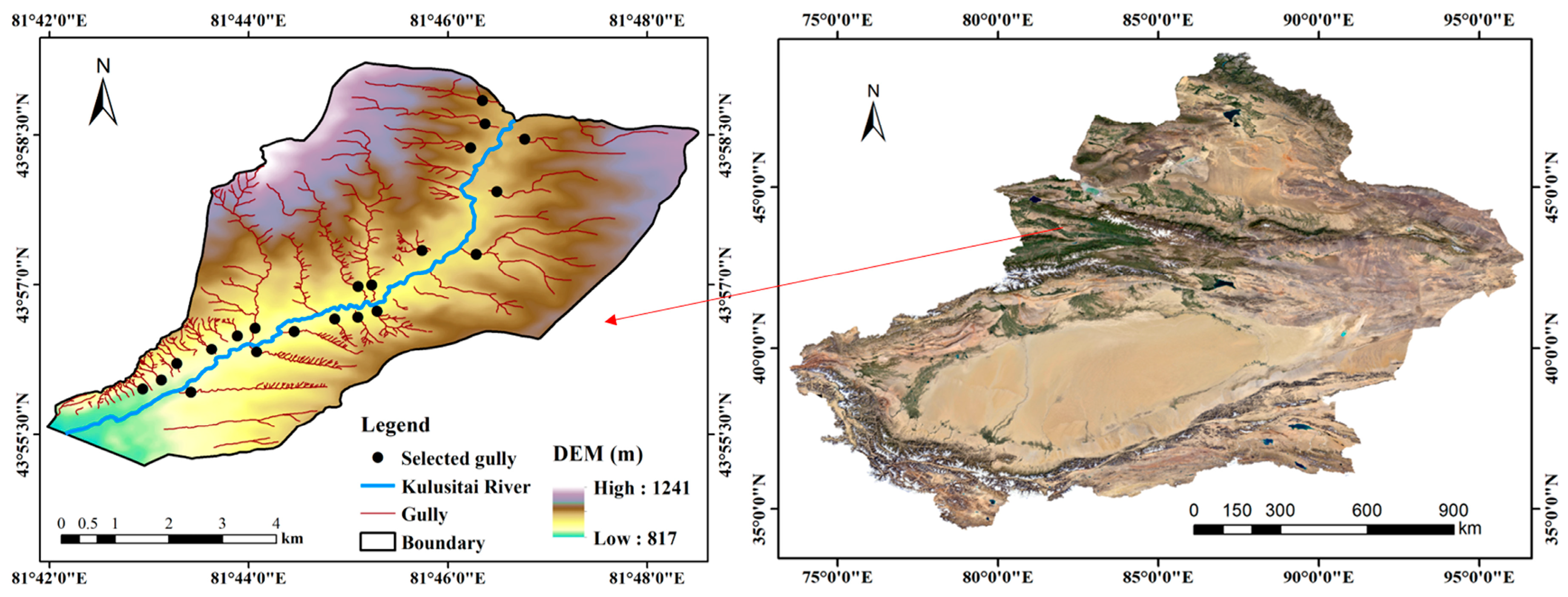
2.1. Study Area
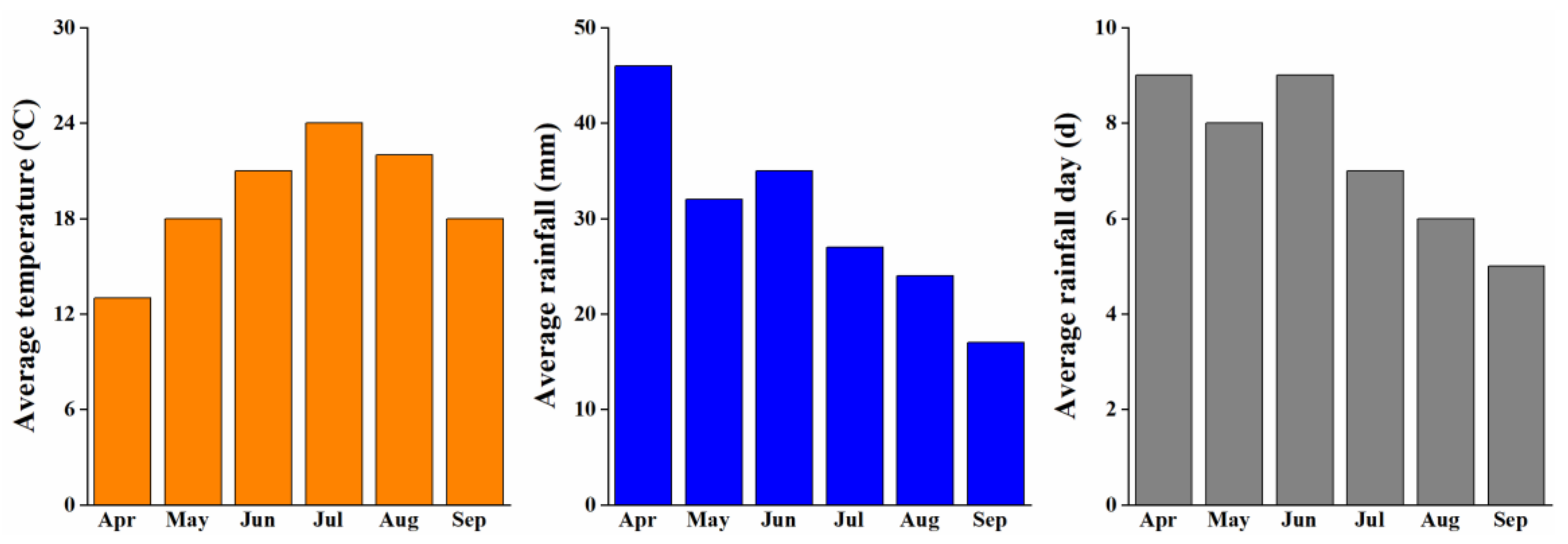
2.2. Data Source
2.3. Measurement of Gully Characteristics
2.4. Evaluation of Runoff Potential in Catchment
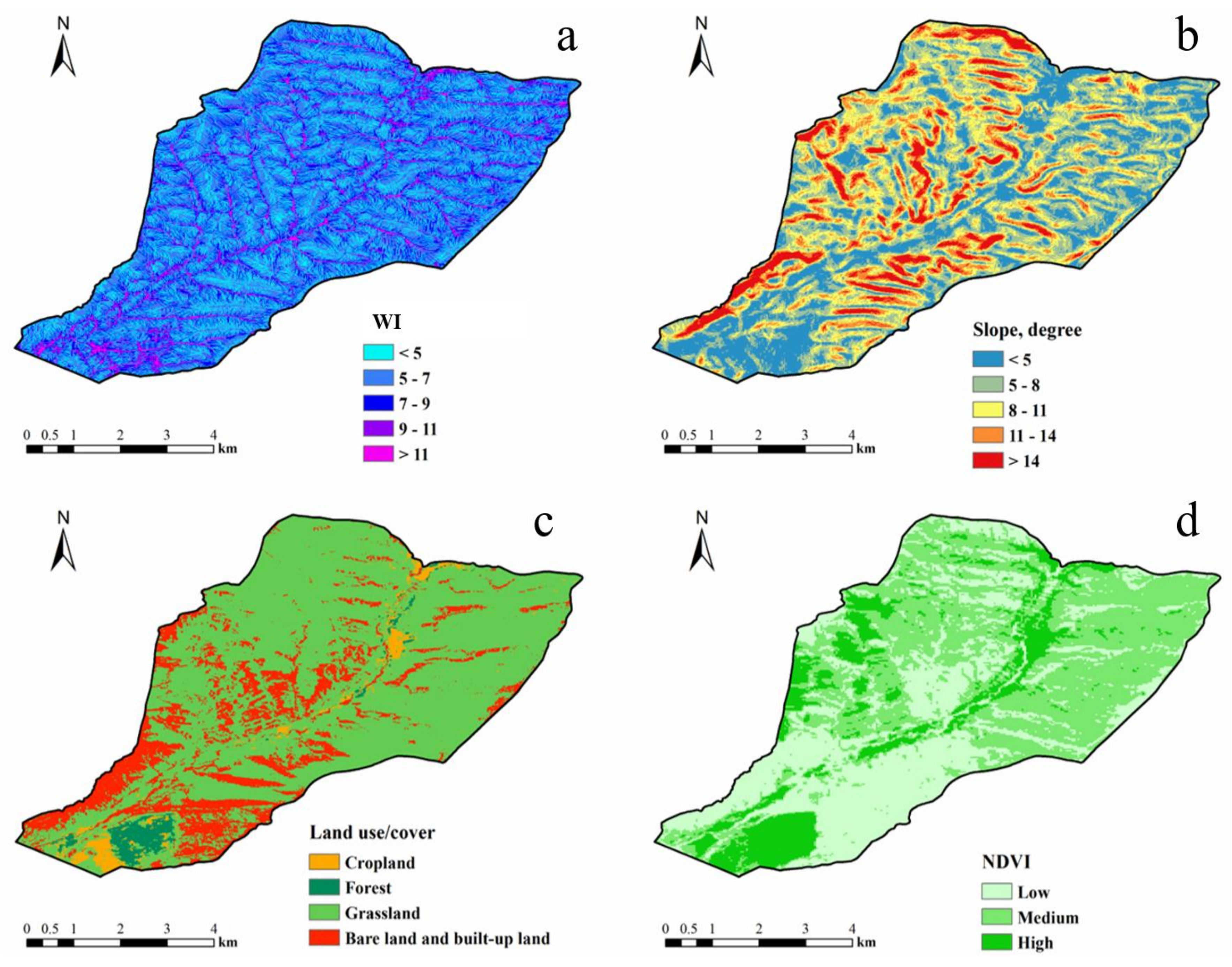
2.4.1. Criteria Selection
2.4.2. Data Analysis
3. Results
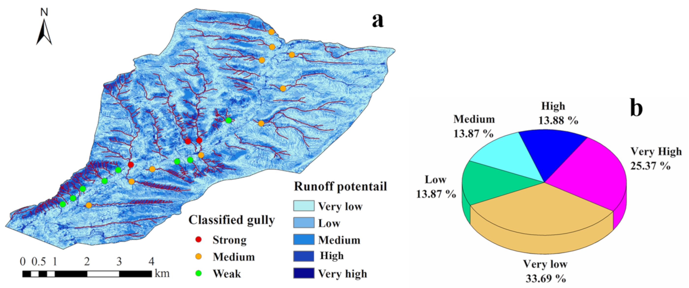
3.1. Runoff Potential
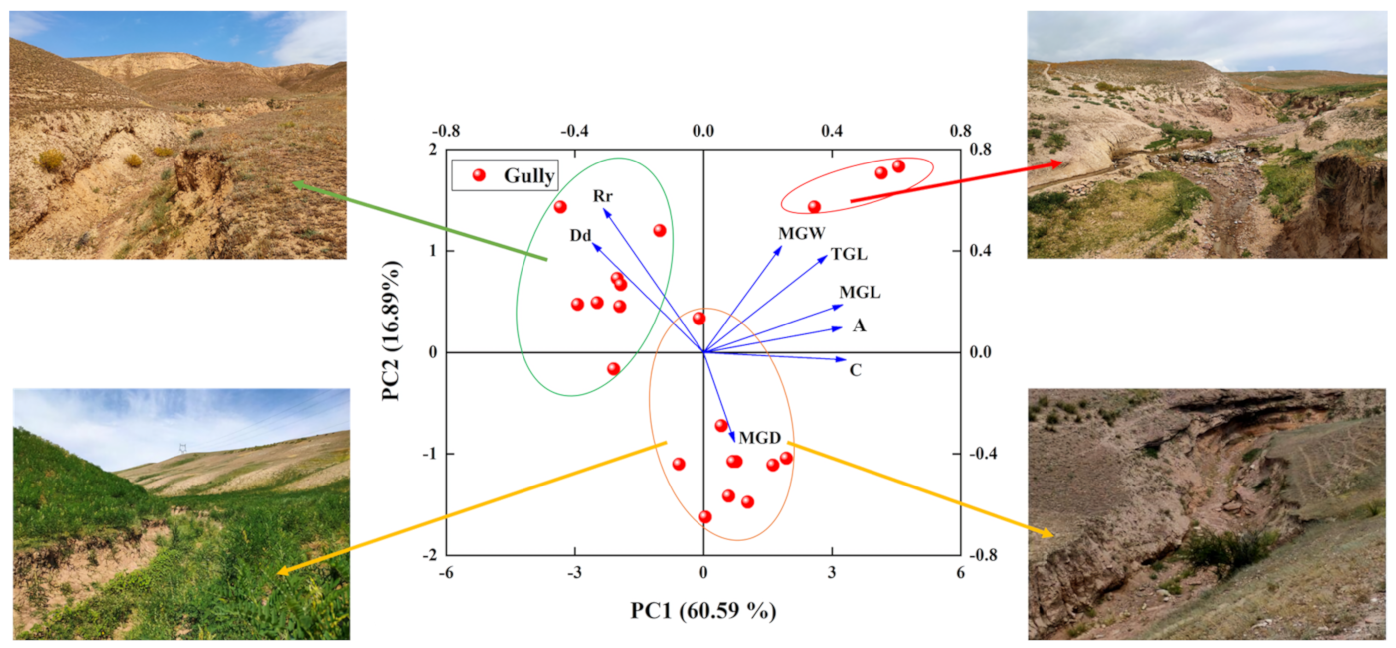
3.2. Characteristics of Gullies
4. Discussion
4.1. Relationship between Gully Characteristics and Catchment
4.2. Selection of Suitable RWH Techniques in Gully
5. Conclusions
Author Contributions
Funding
Acknowledgments
Conflicts of Interest
References
- Poesen, J.; Nachtergaele, J.; Verstraeten, G.; Valentin, C. Gully erosion and environmental change: Importance and research needs. Catena 2003, 50, 91–133. [Google Scholar] [CrossRef]
- Zhang, W.T.; Zhou, J.Q.; Feng, G.L.; Weindorf, D.C.; Hu, G.Q.; Sheng, J.D. Characteristics of water erosion and conservation practice in arid regions of Central Asia: Xinjiang, China as an example. Int. Soil Water Conserv. 2015, 3, 97–111. [Google Scholar] [CrossRef]
- Wilkinson, S.N.; Kinsey-Henderson, A.E.; Hawdon, A.A.; Hairsine, P.B.; Bartley, R.; Baker, B. Grazing impacts on gully dynamics indicate approaches for gully erosion control in northeast Australia. Earth Surf. Process. Landf. 2018, 43, 1711–1725. [Google Scholar] [CrossRef]
- Stavi, I.; Perevolotsky, A.; Avni, Y. Effects of gully formation and headcut retreat on primary production in an arid rangeland: Natural desertification in action. J. Arid. Environ. 2010, 74, 221–228. [Google Scholar] [CrossRef]
- Melliger, J.; Niemann, J.D. Effects of gullies on space-time patterns of soil moisture in a semiarid grassland. J. Hydrol. 2010, 389, 289–300. [Google Scholar] [CrossRef]
- Avni, Y. Gully incision as a key factor in desertification in an arid environment, the Negev highlands, Israel. Catena 2005, 63, 185–220. [Google Scholar] [CrossRef]
- Wang, B.; Zhang, M.J.; Wei, J.L.; Wang, S.J.; Li, S.S.; Ma, Q.; Li, X.F.; Pan, S.K. Changes in extreme events of temperature and precipitation over Xinjiang, northwest China, during 1960–2009. Quat. Int. 2013, 298, 141–151. [Google Scholar] [CrossRef]
- Zhang, Q.; Singh, V.P.; Li, J.F.; Jiang, F.Q.; Bai, Y.G. Spatio-temporal variations of precipitation extremes in Xinjiang, China. J. Hydrol. 2012, 434–435, 7–18. [Google Scholar] [CrossRef]
- Oweis, T.Y. Rainwater harvesting for restoring degraded dry agro-pastoral ecosystems; a conceptual review of opportunities and constraints in a changing climate. Environ. Rev. 2017, 25, 135–149. [Google Scholar] [CrossRef]
- Biazin, B.; Sterk, G.; Temesgen, M.; Abdulkedir, A.; Stroosnijder, L. Rainwater harvesting and management in rainfed agricultural systems in sub-Saharan Africa-A review. Phys. Chem. Earth 2012, 139–151. [Google Scholar] [CrossRef]
- Senkondo, E.M.M.; Msangi, A.S.K.; Xavery, P.; Lazaro, E.A.; Hatibu, N. Profitability of rainwater harvesting for agricultural production in selected semi-arid areas of Tanzania. J. Appl. Irrig. Sci. 2004, 39, 65–81. [Google Scholar]
- Larry, W.M. Use of cisterns during antiquity in the Mediterranean region for water resources sustainability. Water Sci. Technol. Water Supply 2014, 14, 38–47. [Google Scholar]
- Castelli, G.; Oliveira, L.A.A.; Abdelli, F.; Dhaou, H.; Bresci, E.; Ouessar, M. Effect of traditional check dams (jessour) on soil and olive trees water status in Tunisia. Sci. Total Environ. 2019, 690, 226–236. [Google Scholar] [CrossRef] [PubMed]
- Paz-Kagan, T.; Ohana-Levi, N.; Shachak, M.; Zaady, E.; Karnieli, A. Ecosystem effects of integrating human-made runoff-harvesting systems into natural dryland watersheds. J. Arid. Environ. 2017, 147, 133–143. [Google Scholar] [CrossRef]
- Paz-Kagan, T.; Demalach, N.; Shachak, M.; Zaady, E. Resource redistribution effects on annual plant communities in a runoff harvesting system in dryland. J. Arid. Environ. 2019, 171, 1–14. [Google Scholar] [CrossRef]
- United Nations. Transforming Our World: The 2030 Agenda for Sustainable Development, A/RES/70/1. 2015. Available online: https://sustainabledevelopment.un.org/content/documents/21252030%20Agenda%20for%20Sustainable%20Development%20web.pdf (accessed on 8 June 2020).
- Ammar, A.; Riksen, M.; Ouessar, M.; Ritsema, C. Identification of suitable sites for rainwater harvesting structures in arid and semi-arid regions: A review. Int. Soil Water Conserv. 2016, 4, 108–120. [Google Scholar] [CrossRef]
- Stavi, I.; Siad, S.M.; Kyriazopoulos, A.P.; Halbac-Cotoara-Zamfir, R. Water runoff harvesting systems for restoration of degraded rangelands: A review of challenges and opportunities. J. Environ. Manag. 2020, 255, 1–13. [Google Scholar] [CrossRef]
- Mbilinyi, B.P.; Tumbo, S.D.; Mahoo, H.F.; Mkiramwinyi, F.O. GIS-based decision support system for identifying potential sites for rainwater harvesting. Phys. Chem. Earth 2007, 32, 1074–1081. [Google Scholar] [CrossRef]
- Mukai, S. Gully erosion rates and analysis of determining factors: A case study from the semi-arid main Ethiopian rift valley. Land Degrad. Dev. 2017, 28, 602–615. [Google Scholar] [CrossRef]
- Mahmoud, S.H.; Adamowski, J.; Alazba, A.A.; El-Gindy, A.M. Rainwater harvesting for the management of agricultural droughts in arid and semi-arid regions. Paddy Water Environ. 2016, 14, 231–246. [Google Scholar] [CrossRef]
- Sushanth, K.; Bhardwaj, A. Assessing geomorphologic characteristics and demarcating runoff potential zones using RS and GIS in Patiala-Ki-Rao watershed of Shivalik foot-hills, Punjab. J. Agric. Eng. 2019, 56, 45–54. [Google Scholar]
- Ammar, A.; Khamis, N.S.; Rasha, A.; Mohamed, A.A.; Jan, G.W.; Michel, R.; Luuk, F.; Usama, K.; Coen, J.R. A GIS-based approach for identifying potential sites for harvesting rainwater in the western desert of Iraq. Int. Soil Water Conserv. 2018, 6, 297–304. [Google Scholar]
- Shadeed, S.; Judeh, T.; Riksen, M. Rainwater harvesting for sustainable agriculture in high water-poor areas in the west bank, Palestine. Water 2020, 12, 380. [Google Scholar] [CrossRef]
- Ibrahim, G.R.F.; Rasul, A.; Hamid, A.A.; Ali, Z.F.; Dewana, A.A. Suitable site selection for rainwater harvesting and storage case study using Dohuk Governorate. Water 2019, 11, 864. [Google Scholar] [CrossRef]
- Luo, H.; Hu, X.N.; Xie, Y.S.; Wang, J.J.; Guo, M.C. Constructions of an evaluation framework for soil and water conservation techniques. Catena 2020, 186, 1–10. [Google Scholar] [CrossRef]
- IUSS Working Group WRB. World Reference Base for Soil Resources 2014. International Soil Classification System for Naming Soils and Creating Legends for Soil Maps; World Soil Resources Reports; FAO: Rome, Italy, 2015. [Google Scholar]
- Zhu, C.G.; Li, W.H.; Li, D.L.; Liu, M.Z.; Fu, L. Feature analysis of soil physicochemical properties and erodibility of the Yili Valley. Resour. Sci. 2016, 38, 1212–1221, (In Chinese with English abstract). [Google Scholar]
- Li, Z.; Zhang, W.T.; Xuan, J.W. Characteristics of heavy rainfall in Yining City from 1956 to 2015 and its impact on flood. Water Resour. Protect. 2018, 34, 49–55, (In Chinese with English abstract). [Google Scholar]
- Gong, P.; Liu, H.; Zhang, M.N.; Li, C.C.; Wang, J.; Huang, H.B.; Clinton, N.; Ji, L.Y.; Li, W.Y.; Bai, Y.Q.; et al. Stable classification with limited sample: Transferring a 30-m resolution sample set collected in 2015 to mapping 10-m resolution global land cover in 2017. Sci. Bull. 2019, 64, 370–373. [Google Scholar] [CrossRef]
- Schumm, S.A. The evolution of drainage systems and slopes in badlands at Perth Amboy, New Jersey. Bull. Geol. Soc. Am. 1956, 67, 597–646. [Google Scholar] [CrossRef]
- Horton, R.E. Drainage basin characteristics. Trans. Am. Geophys. Union 1932, 13, 350–361. [Google Scholar] [CrossRef]
- Beven, K.J.; Kirkby, M.J. A physically-based variable contributing area model of basin hydrology. Hydrol. Sci. J. 1979, 24, 43–69. [Google Scholar] [CrossRef]
- Justice, C.O.; Townshend, J.R.G.; Holben, B.N.; Tucker, C.J. Analysis of the phenology of global vegetation using meteorological satellite data. Int. J. Remote Sens. 1985, 6, 1271–1318. [Google Scholar] [CrossRef]
- Zhang, C.X.; Yang, Q.K.; Li, R. Advancement in topographic wetness index and its application. Process. Geogr. 2005, 24, 116–123, (In Chinese with English abstract). [Google Scholar]
- Kadam, A.K.; Kale, S.S.; Pande, N.N.; Pawar, N.J.; Sankhua, R.N. Identifying potential rainwater harvesting sites of a semi-arid, basaltic region of western India, using SCS-CN method. Water Resour. Manag. 2012, 26, 2537–2554. [Google Scholar] [CrossRef]
- Yu, M.Z.; Zhang, L.L.; Xu, X.X.; Feger, K.H.; Wang, Y.H.; Liu, W.Z.; Schwärzel, K. Impact of land-use changes on soil hydraulic properties of Calcaric Regosols on the Loess Plateau, NW China. J. Plant. Nutr. Soil Sci. 2015, 178, 486–498. [Google Scholar] [CrossRef]
- Wang, D.D.; Yu, X.X.; Jia, G.D.; Wang, H.N. Sensitivity analysis of runoff to climate variability and land-use changes in the Haihe Basin mountainous area of north China. Agric. Ecosyst. Environ. 2019, 269, 193–203. [Google Scholar] [CrossRef]
- Cao, L.X.; Zhang, Y.G.; Lu, H.Z.; Yuan, J.Q.; Zhu, Y.Y.; Liang, Y. Grass hedge effects on controlling soil loss from concentrated flow: A case study in the red soil region of China. Soil Tillage Res. 2015, 148, 97–105. [Google Scholar] [CrossRef]
- Xiong, M.Q.; Sun, R.H.; Chen, L.D. Effects of soil conservation techniques on water erosion control: A global analysis. Sci. Total Environ. 2018, 645, 753–760. [Google Scholar] [CrossRef]
- Zhang, W.T.; Hu, G.Q.; Dang, Y.; Weindorf, D.C.; Sheng, J.D. Afforestation and the impacts on soil and water conservation at decadal and regional scales in northwest China. J. Arid. Environ. 2016, 130, 98–104. [Google Scholar] [CrossRef]
- Saaty, T.L. Decision making with the analytic hierarchy process. Int. J. Serv. Sci. 2008, 1, 83–98. [Google Scholar] [CrossRef]
- Saaty, T.L. Rank generation, preservation, and reversal in the analytic hierarchy decision process. Decis. Sci. 1987, 18, 157–177. [Google Scholar] [CrossRef]
- Zhang, S.B.; Li, J.G.; Huang, J.H.; Zhang, W.T.; Yang, W.Y.; Wang, F. Impact of the grass coverage on runoff and sediment in the Yili river valley. Acta Agri. U Jiangxi 2016, 38, 995–1101. [Google Scholar]
- Zhang, T.Y.; Liu, G.; Duan, X.W.; Wilson, G.V. Spatial distribution and morphologic characteristics of gullies in the Black Soil Region of Northeast China: Hebei watershed. Phys. Geogr. 2016, 37, 228–250. [Google Scholar] [CrossRef]
- Zhao, J.J.; Vanmaercke, M.; Chen, L.Q.; Govers, G. Vegetation cover and topography rather than human disturbance control gully density and sediment production on the Chinese Loess Plateau. Geomorphology 2016, 274, 92–105. [Google Scholar] [CrossRef]
- Desmet, P.J.J.; Poesen, J.; Govers, G.; Vandaele, K. Importance of slope gradient and contributing area for optimal prediction of the initiation and trajectory of ephemeral gullies. Catena 1999, 37, 377–392. [Google Scholar] [CrossRef]
- Torri, D.; Poesen, J.; Borselli, L.; Knapen, A. Channel width-flow discharge relationships for rills and gullies. Geomorphology 2006, 76, 273–279. [Google Scholar] [CrossRef]
- Torri, D.; Poesen, J. A review of topographic threshold conditions for gully head development in different environments. Earth Sci. Rev. 2014, 130, 73–85. [Google Scholar] [CrossRef]
- Zhang, B.J.; Xiong, D.H.; Su, Z.G.; Yang, D.; Dong, Y.F.; Xiao, L.; Zhang, S.; Shi, L.T. Effects of initial step height on the headcut erosion of bank gullies: A case study using a 3D photo-reconstruction method in the dry-hot valley region of southwest China. Phys. Geogr. 2016, 37, 409–429. [Google Scholar] [CrossRef]
- Djuma, H.; Bruggeman, A.; Camera, C.; Eliades, M.; Kostarelos, K. The impact of a check dam on groundwater recharge and sedimentation in an ephemeral stream. Water 2017, 9, 813. [Google Scholar] [CrossRef]
- Calianno, M.; Fallot, J.M.; Ben Fraj, T.; Ben Ouezdou, H.; Reynard, E.; Milano, M.; Abbassi, M.; Ghram Messedi, A.; Adatte, T. Benefits of water-harvesting systems (Jessour) on soil water retention in Southeast Tunisia. Water 2020, 12, 295. [Google Scholar] [CrossRef]
- Samani, A.A.N.; Khalighi, S.; Arabkhedri, M.; Farzadmehr, I. Indigenous knowledge and techniques of runoff harvesting (Bandsar and Khooshab) in arid and semi-arid regions of Iran. J. Water Resour. Protect. 2014, 6, 784–792. [Google Scholar] [CrossRef][Green Version]
- Yami, T.L. Enhancement of small-scale runoff harvesting ponds in East Africa. J. Nat. Sci. Res. 2019, 9, 1–19. [Google Scholar]
- Zhu, Q.; Gould, J.; Li, Y.; Ma, C.X. Rainwater Harvesting for Agriculture and Water Supply; Science Press: Beijing, China, 2015; pp. 3–43. [Google Scholar]
- Zhang, J.Z.; Yu, Z.Q.; Yu, T.F.; Si, J.H.; Feng, Q.; Cao, S.X. Transforming flash floods into resources in arid China. Land Use Policy 2018, 76, 746–753. [Google Scholar] [CrossRef]
- Nasri, S.; Albergel, J.; Cudennec, C.; Berndtsson, R. Hydrological processes in macrocatchment water harvesting in the arid region of Tunisia: The traditional system of tabias. Hydrol. Sci. J. 2004, 49, 272. [Google Scholar] [CrossRef]
- Kimiti, D.W.; Riginos, C.; Belnap, J. Low-cost grass restoration using erosion barriers in a degraded African rangeland. Restor. Ecol. 2017, 25, 376–384. [Google Scholar] [CrossRef]
- Nyssen, J.; Veyret-Picot, M.; Poesen, J.; Moeyersons, J.; Haile, M.; Deckers, J.; Govers, G. The effectiveness of loose rock check dams for gully control in Tigray, Northern Ethiopia. Soil Use Manag. 2006, 20, 55–64. [Google Scholar] [CrossRef]
- Sayl, K.N.; Muhammad, N.S.; Yaseen, Z.M.; El-shafie, A. Estimation the physical variables of rainwater harvesting system using integrated GIS-based remote sensing approach. Water Resour. Manag. 2016, 30, 3299–3313. [Google Scholar] [CrossRef]


| Parameter | Measurement and Calculation of Parameters |
|---|---|
| Main gully length (MGL) | Field survey and calculated in GIS |
| Total gully length (TGL) | Field survey and calculated in GIS |
| Main gully width (MGW) | Field survey |
| Main gully depth (MGD) | Field survey |
| Circumference of catchment (C) | Field survey and calculated in GIS |
| Area of catchment (A) | Field survey and calculated in GIS |
| Relief ratio (Rr) | Rr = H/L, L is maximum catchment length (m); H is height (m) difference between highest point and lowest point in catchment [31]. |
| Drainage density (Dd) | Dd = TGL/A [32] |
| Slope (S) | Analyzed DEM in GIS |
| Topographic wetness index (WI) | WI = ln (Ac/tanS), Ac is the potential contributing area [33] |
| Normalized difference vegetation index (NDVI) | NDVI = (NIR − R)/(NIR + R), NIR and R are the spectral reflectance in the near infrared band and red band [34] |
| Land use/cover | Data from Gong’s classification system and field survey [30] |
| Characteristic | Theme Weight | Class | Assigned Class Weight | Consistency Ratio |
|---|---|---|---|---|
| WI | 0.4918 | <5 | 0.0422 | 0.0385 |
| 5–7 | 0.0625 | |||
| 7–9 | 0.1367 | |||
| 9–11 | 0.2089 | |||
| >11 | 0.5498 | |||
| Slope (degree) | 0.3056 | <5 | 0.0347 | 0.0523 |
| 5–8 | 0.0696 | |||
| 8–11 | 0.1411 | |||
| 11–14 | 0.2136 | |||
| >14 | 0.5437 | |||
| Land use/cover | 0.1248 | Bare land and built-up land | 0.6106 | 0.0452 |
| Cropland | 0.2160 | |||
| Grassland | 0.1297 | |||
| Forest | 0.0437 | |||
| NDVI | 0.0778 | Low | 0.6370 | 0.0370 |
| Medium | 0.2583 | |||
| High | 0.1047 |
| Classified Gullies | MGL(km) | TGL(km) | MGW(m) | MGD(m) | C(km) | A(km2) | Dd(km/km2) | Rr |
|---|---|---|---|---|---|---|---|---|
| Weak gully | 0.650c± 0.05 | 1.459b± 0.29 | 4.62b± 1.04 | 1.63b± 0.12 | 1.64c± 0.15 | 0.13c± 0.02 | 12.4a± 1.75 | 0.133a± 0.0049 |
| Medium gully | 1.483b± 0.13 | 2.293b± 0.26 | 5.41b± 0.84 | 3.52a± 0.55 | 4.60b± 0.34 | 0.96b± 0.14 | 3.05b± 0.79 | 0.067b± 0.0064 |
| Strong gully | 3.300a± 0.27 | 6.366a± 1.13 | 9.97a± 0.70 | 1.71b± 0.22 | 7.96a± 0.71 | 2.43a± 0.31 | 2.57b± 0.17 | 0.091b± 0.0045 |
© 2020 by the authors. Licensee MDPI, Basel, Switzerland. This article is an open access article distributed under the terms and conditions of the Creative Commons Attribution (CC BY) license (http://creativecommons.org/licenses/by/4.0/).
Share and Cite
Li, Z.; Zhang, W.; Aikebaier, Y.; Dong, T.; Huang, G.; Qu, T.; Zhang, H. Sustainable Development of Arid Rangelands and Managing Rainwater in Gullies, Central Asia. Water 2020, 12, 2533. https://doi.org/10.3390/w12092533
Li Z, Zhang W, Aikebaier Y, Dong T, Huang G, Qu T, Zhang H. Sustainable Development of Arid Rangelands and Managing Rainwater in Gullies, Central Asia. Water. 2020; 12(9):2533. https://doi.org/10.3390/w12092533
Chicago/Turabian StyleLi, Zheng, Wentai Zhang, Yilahong Aikebaier, Tong Dong, Guoping Huang, Tao Qu, and Hexin Zhang. 2020. "Sustainable Development of Arid Rangelands and Managing Rainwater in Gullies, Central Asia" Water 12, no. 9: 2533. https://doi.org/10.3390/w12092533
APA StyleLi, Z., Zhang, W., Aikebaier, Y., Dong, T., Huang, G., Qu, T., & Zhang, H. (2020). Sustainable Development of Arid Rangelands and Managing Rainwater in Gullies, Central Asia. Water, 12(9), 2533. https://doi.org/10.3390/w12092533