The Impact of Reforestation Induced Land Cover Change (1990–2017) on Flood Peak Discharge Using HEC-HMS Hydrological Model and Satellite Observations: A Study in Two Mountain Basins, China
Abstract
:1. Introduction
2. Data and Research Methods
2.1. Study Area
2.2. Sources of Data
2.3. Satellite Image Processing and Land Use Land Cover Classification
2.4. Land Use Land Cover Change and Vegetation Analysis
2.5. Hydrological Modeling Using HEC-GeoHMS and HEC-HMS
2.5.1. The Basin Model
2.5.2. Meteorological Model
2.5.3. The HEC-HMS Model Control Specifications
2.5.4. Curve Number Loss Method
2.5.5. Soil Conservation Service (SCS) Unit Hydrograph Method
2.5.6. Routing Method
2.5.7. Simulated Land Use Land Cover Change Scenarios
3. Results and Discussion
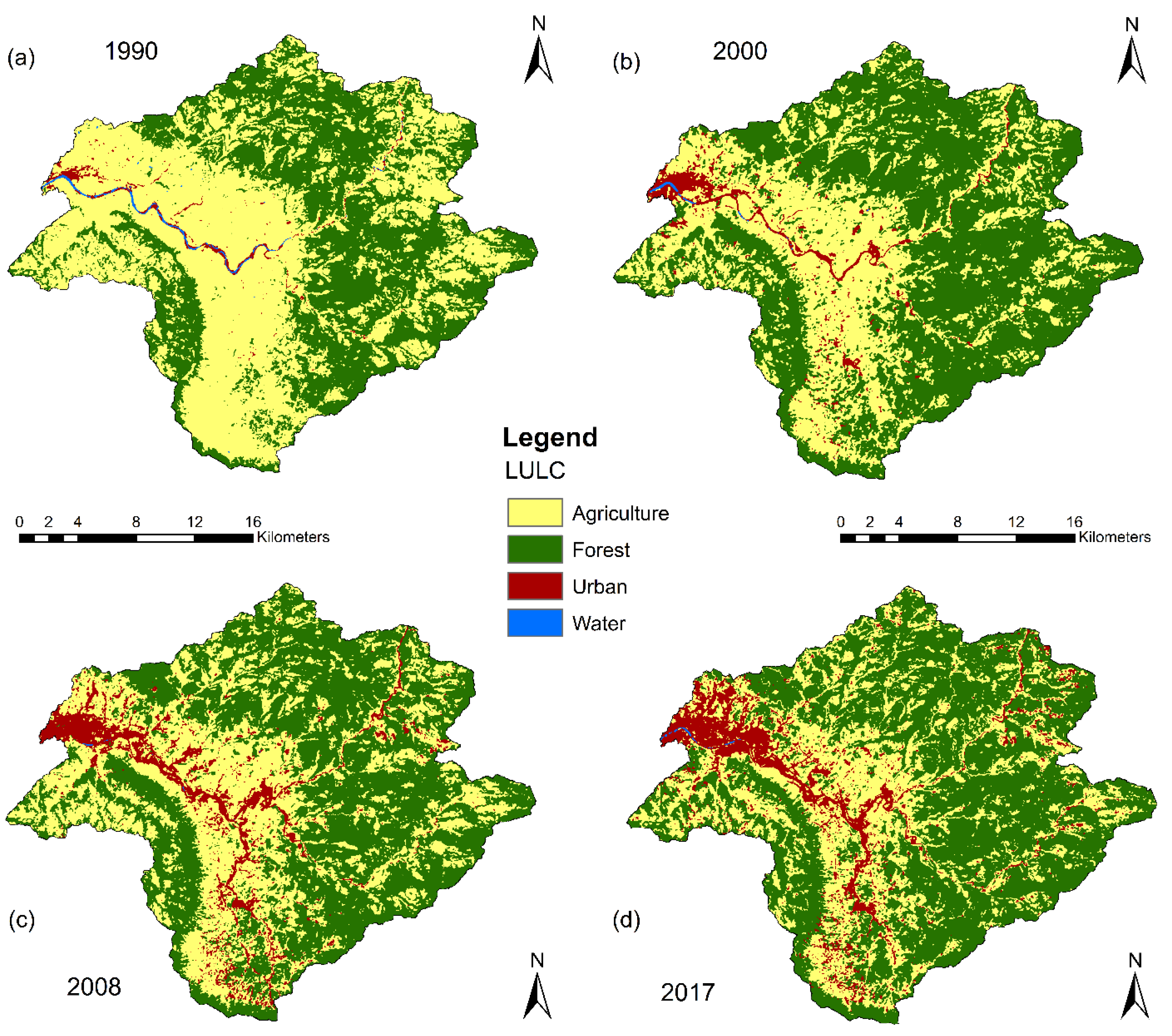
3.1. Land Use Land Cover Classification and Change Detection Analysis
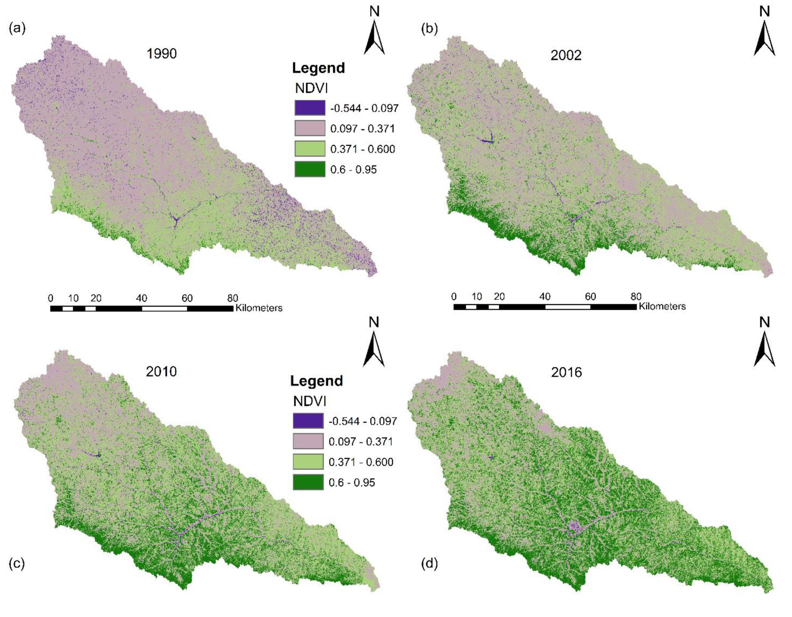
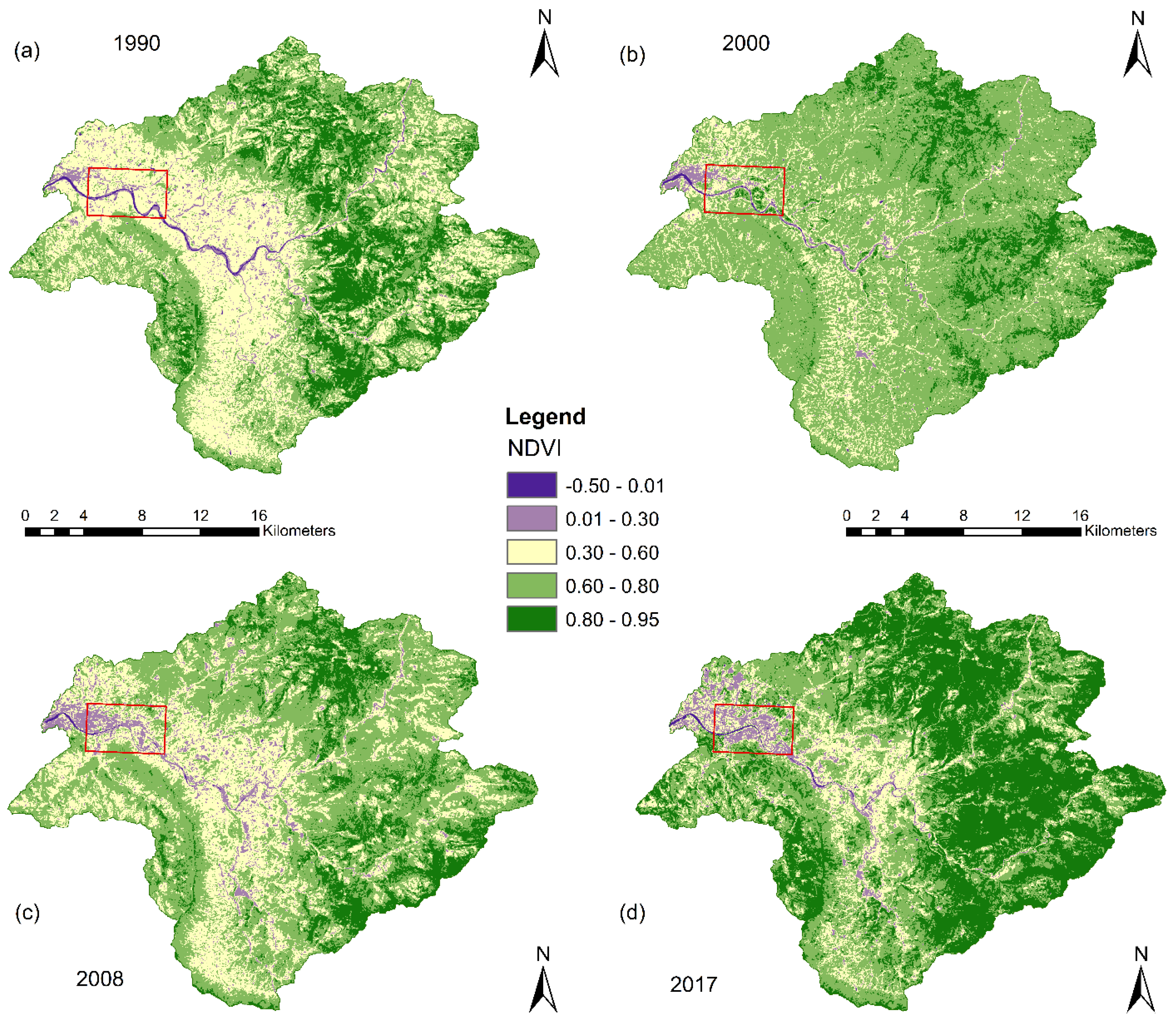
3.2. Vegetation Analysis
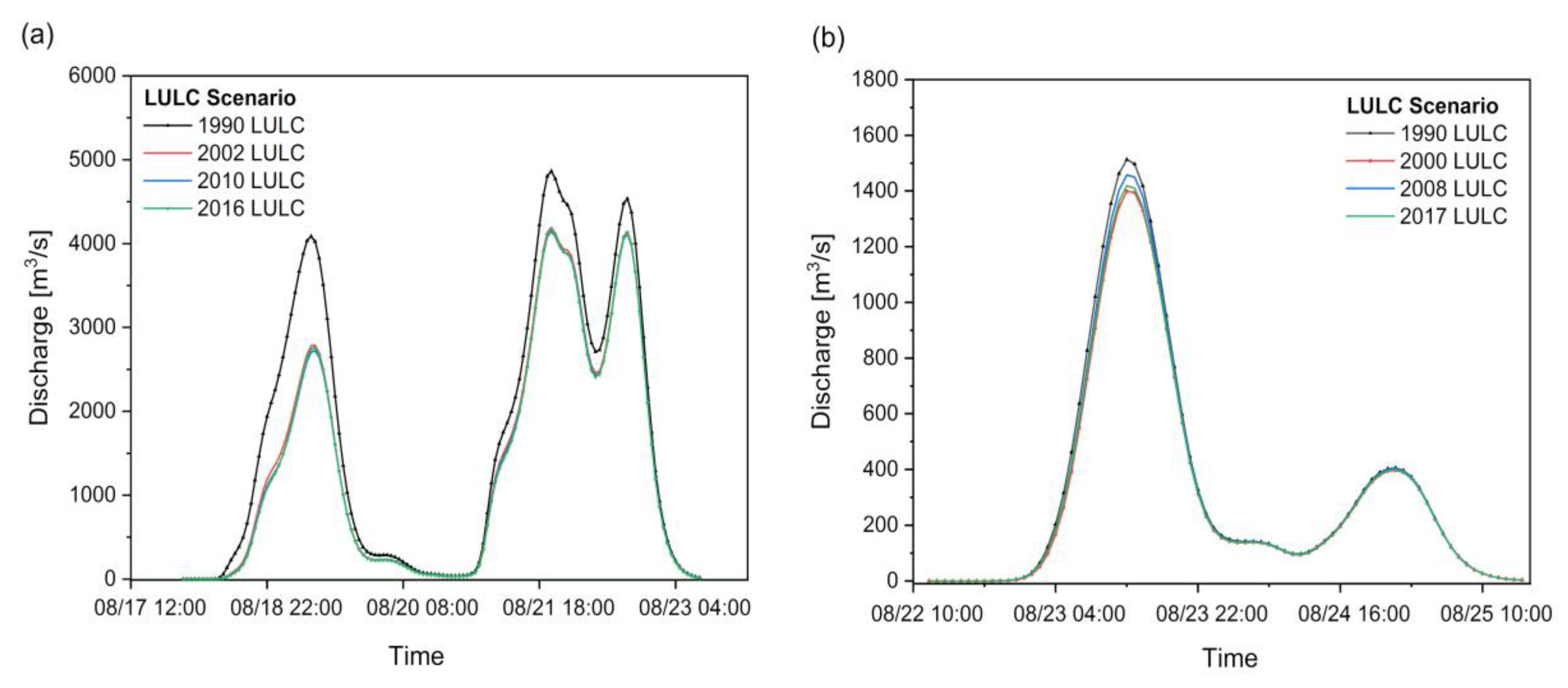
3.3. Impact of Reforestation Driven LULC Changes on Flood Peak Discharge
3.4. Spatial Variability of Flood Peak Discharge at the Sub-Basin Scale
3.5. Limitations
4. Summary and Conclusions
Author Contributions
Funding
Acknowledgments
Conflicts of Interest
References
- Diakakis, M.; Priskos, G.; Skordoulis, M. Public perception of flood risk in flash flood prone areas of Eastern Mediterranean: The case of Attica Region in Greece. Int. J. Disaster Risk Reduct. 2018, 28, 404–413. [Google Scholar] [CrossRef]
- Hrachowitz, M.; Savenije, H.H.G.; Blöschl, G.; McDonnell, J.J.; Sivapalan, M.; Pomeroy, J.W.; Arheimer, B.; Blume, T.; Clark, M.P.; Ehret, U.; et al. A decade of Predictions in Ungauged Basins (PUB)—A review. Hydrol. Sci. J. 2013, 58, 1198–1255. [Google Scholar] [CrossRef]
- Kourgialas, N.N.; Karatzas, G.P. A national scale flood hazard mapping methodology: The case of Greece—Protection and adaptation policy approaches. Sci. Total. Environ. 2017, 601, 441–452. [Google Scholar] [CrossRef] [PubMed]
- Rozalis, S.; Morin, E.; Yair, Y.; Price, C. Flash flood prediction using an uncalibrated hydrological model and radar rainfall data in a Mediterranean watershed under changing hydrological conditions. J. Hydrol. 2010, 394, 245–255. [Google Scholar] [CrossRef]
- Modrick, T.M.; Georgakakos, K.P. The character and causes of flash flood occurrence changes in mountainous small basins of Southern California under projected climatic change. J. Hydrol. Reg. Stud. 2015, 3, 312–336. [Google Scholar] [CrossRef] [Green Version]
- Skougaard Kaspersen, P.; Høegh Ravn, N.; Arnbjerg-Nielsen, K.; Madsen, H.; Drews, M. Comparison of the impacts of urban development and climate change on exposing European cities to pluvial flooding. Hydrol. Earth Syst. Sci. 2017, 21, 4131–4147. [Google Scholar] [CrossRef] [Green Version]
- Douinot, A.; Roux, H.; Garambois, P.A.; Larnier, K.; Labat, D.; Dartus, D. Accounting for rainfall systematic spatial variability in flash flood forecasting. J. Hydrol. 2016, 541, 359–370. [Google Scholar] [CrossRef] [Green Version]
- Li, W.; Lin, K.; Zhao, T.; Lan, T.; Chen, X.; Du, H.; Chen, H. Risk assessment and sensitivity analysis of flash floods in ungauged basins using coupled hydrologic and hydrodynamic models. J. Hydrol. 2019, 572, 108–120. [Google Scholar] [CrossRef]
- Rodriguez-Morata, C.; Ballesteros-cánovas, J.A.; Trappmann, D.; Beniston, M.; Stoffel, M. Regional reconstruction of flash flood history in the Guadarrama range (Central System, Spain). Sci. Total. Environ. 2016, 550, 406–417. [Google Scholar] [CrossRef] [Green Version]
- Zhang, Y.; Peng, C.; Li, W.; Tian, L.; Zhu, Q.; Chen, H.; Fang, X.; Zhang, G.; Liu, G.; Mu, X.; et al. Multiple afforestation programs accelerate the greenness in the ‘Three North’ region of China from 1982 to 2013. Ecol. Indic. 2015, 61, 404–412. [Google Scholar] [CrossRef]
- Liu, J.; Shi, Z.-W. Quantifying land-use change impacts on the dynamic evolution of flood vulnerability. Land Use Policy 2017, 65, 198–210. [Google Scholar] [CrossRef]
- Wang, X.; Zhou, M.; Li, T.; Ke, Y.; Zhu, B. Land use change effects on ecosystem carbon budget in the Sichuan Basin of Southwest China: Conversion of cropland to forest ecosystem. Sci. Total. Environ. 2017, 609, 556–562. [Google Scholar] [CrossRef] [PubMed]
- Jiang, Y.; Zevenbergen, C.; Ma, Y. Urban pluvial flooding and stormwater management: A contemporary review of China’s challenges and “sponge cities” strategy. Environ. Sci. Policy 2018, 80, 132–143. [Google Scholar] [CrossRef]
- Miao, Q.; Yang, D.; Yang, H.; Li, Z. Establishing a rainfall threshold for flash flood warnings in China’s mountainous areas based on a distributed hydrological model. J. Hydrol. 2016, 541, 371–386. [Google Scholar] [CrossRef]
- Liu, J.; Li, S.; Ouyang, Z.; Tam, C.; Chen, X. Ecological and socioeconomic effects of China ’ s policies for ecosystem services. Proc. Natl. Acad. Sci. USA 2007. [Google Scholar] [CrossRef] [Green Version]
- Yang, L.; Wei, W.; Chen, L.; Mo, B. Response of deep soil moisture to land use and afforestation in the semi-arid Loess Plateau, China. J. Hydrol. 2012, 475, 111–122. [Google Scholar] [CrossRef]
- Sun, D.; Zhang, D.; Cheng, X. Framework of national non-structural measures for flash flood disaster prevention in China. Water 2012, 4, 272–282. [Google Scholar] [CrossRef]
- Posthumus, H.; Hewett, C.J.M.; Morris, J.; Quinn, P.F. Agricultural land use and flood risk management: Engaging with stakeholders in North Yorkshire. Agric. Water Manag. 2008, 95, 787–798. [Google Scholar] [CrossRef]
- Li, J.; Wang, Z.; Lai, C.; Wu, X.; Zeng, Z.; Chen, X.; Lian, Y. Response of net primary production to land use and land cover change in mainland China since the late 1980s. Sci. Total. Environ. 2018, 639, 237–247. [Google Scholar]
- Sun, W.; Song, X.; Mu, X.; Gao, P.; Wang, F.; Zhao, G. Spatiotemporal vegetation cover variations associated with climate change and ecological restoration in the Loess Plateau. Agric. For. Meteorol. 2015, 209, 87–99. [Google Scholar] [CrossRef]
- Ghaffari, G.; Keesstra, S.; Ghodousi, J.; Ahmadi, H. SWAT-simulated hydrological impact of land-use change in the Zanjanrood Basin, Northwest Iran. Hydrol. Process. 2010, 24, 892–903. [Google Scholar] [CrossRef]
- Jansson, P.-E.; Kalantari, Z.; Folkeson, L.; Sassner, M.; Lyon, S.W.; Stolte, J.; French, H.K. Quantifying the hydrological impact of simulated changes in land use on peak discharge in a small catchment. Sci. Total Environ. 2013, 466–467, 741–754. [Google Scholar] [CrossRef]
- Liu, J.; Shi, Z.; Wang, D. Measuring and mapping the flood vulnerability based on land-use patterns: A case study of Beijing, China. Nat. Hazards 2016, 83, 1545–1565. [Google Scholar] [CrossRef]
- Juckem, P.F.; Hunt, R.J.; Anderson, M.P.; Robertson, D.M. Effects of climate and land management change on streamflow in the driftless area of Wisconsin. J. Hydrol. 2008, 355, 123–130. [Google Scholar] [CrossRef]
- Zhang, Y.; Guan, D.; Jin, C.; Wang, A.; Wu, J.; Yuan, F. Impacts of climate change and land use change on runoff of forest catchment in northeast China. Hydrol. Process. 2014, 28, 186–196. [Google Scholar] [CrossRef]
- Liu, M.; Tian, H.; Yang, Q.; Yang, J.; Song, X.; Lohrenz, S.E.; Cai, W.J. Long-term trends in evapotranspiration and runoff over the drainage basins of the Gulf of Mexico during 1901–2008. Water Resour. Res. 2013, 49, 1988–2012. [Google Scholar] [CrossRef]
- Chu, H.J.; Lin, Y.P.; Huang, C.W.; Hsu, C.Y.; Chen, H.Y. Modelling the hydrologic effects of dynamic land-use change using a distributed hydrologic model and a spatial land-use allocation model. Hydrol. Process. 2010, 24, 2538–2554. [Google Scholar] [CrossRef]
- Alkama, R.; Marchand, L.; Ribes, A.; Decharme, B. Detection of global runoff changes: Results from observations and CMIP5 experiments. Hydrol. Earth Syst. Sci. 2013, 17, 2967–2979. [Google Scholar] [CrossRef] [Green Version]
- Wilk, J.; Andersson, L.; Plermkamon, V. Hydrological impacts of forest conversion to agriculture in a large river basin in Northeast Thailand. Hydrol. Process. 2001, 15, 2729–2748. [Google Scholar] [CrossRef]
- Cavalcante, R.B.L.; Pontes, P.R.M.; Souza-Filho, P.W.M.; Souza, E.B. Opposite Effects of Climate and Land Use Changes on the Annual Water Balance in the Amazon Arc of Deforestation. Water Resour. Res. 2019, 55, 3092–3106. [Google Scholar] [CrossRef]
- Lian, J.; Yang, W.; Xu, K.; Ma, C. Flash flood vulnerability assessment for small catchments with a material flow approach. Nat. Hazards 2017, 88, 699–719. [Google Scholar] [CrossRef]
- Zhang, D.-W.; Quan, J.; Zhang, H.-B.; Wang, F.; Wang, H.; He, X.-Y. Flash flood hazard mapping: A pilot case study in Xiapu River Basin, China. Water Sci. Eng. 2015, 8, 195–204. [Google Scholar] [CrossRef] [Green Version]
- Yang, X.; Sun, W.; Li, P.; Mu, X.; Gao, P.; Zhao, G. Reduced sediment transport in the Chinese Loess Plateau due to climate change and human activities. Sci. Total. Environ. 2018, 642, 591–600. [Google Scholar] [CrossRef] [PubMed]
- Zhao, G.; Mu, X.; Jiao, J.; An, Z.; Klik, A.; Wang, F.; Jiao, F.; Yue, X.; Gao, P.; Sun, W. Evidence and Causes of Spatiotemporal Changes in Runoff and Sediment Yield on the Chinese Loess Plateau. J. Land Degrad. Dev. 2017, 9, 1–11. [Google Scholar] [CrossRef]
- Zhang, J.; Wang, T.; Ge, J. Assessing vegetation cover dynamics induced by policy-driven ecological restoration and implication to soil erosion in southern China. PLoS ONE 2015, 10, e0131352. [Google Scholar] [CrossRef]
- Xie, X.; Liang, S.; Yao, Y.; Jia, K.; Meng, S.; Li, J. Detection and attribution of changes in hydrological cycle over the Three-North region of China: Climate change versus afforestation effect. Agric. For. Meteorol. 2015, 203, 74–87. [Google Scholar] [CrossRef]
- Liu, Y.; Yuan, X.; Guo, L.; Huang, Y.; Zhang, X. Driving Force Analysis of the Temporal and Spatial Distribution of Flash Floods in Sichuan Province. Sustainability 2017, 9, 1527. [Google Scholar] [CrossRef] [Green Version]
- FAO; IIASA; ISRIC; ISSCAS; JRC. Harmonized World Soil Database, version 1.2; FAO: Rome, Italy; IIASA: Laxenburg, Austria, 2012. [Google Scholar]
- John, E.W.; Groen, T.A.; Eric, S.; Victor, J. Monitoring basin-scale land cover changes in Kagera Basin of Lake Victoria using ancillary data and remote sensing. Int. J. Appl. Earth Obs. Geoinf. 2013, 21, 32–42. [Google Scholar] [CrossRef]
- Liu, X.; Hu, G.; Chen, Y.; Li, X.; Xu, X.; Li, S.; Pei, F.; Wang, S. High-resolution multi-temporal mapping of global urban land using Landsat images based on the Google Earth Engine Platform. Remote. Sens. Environ. 2018, 209, 227–239. [Google Scholar] [CrossRef]
- Estoque, R.C.; Pontius, R.G.; Murayama, Y.; Hou, H.; Thapa, R.B.; Lasco, R.D.; Villar, M.A. Simultaneous comparison and assessment of eight remotely sensed maps of Philippine forests. Int. J. Appl. Earth Obs. Geoinf. 2018, 67, 123–134. [Google Scholar] [CrossRef]
- Jacobson, A.; Dhanota, J.; Godfrey, J.; Jacobson, H.; Rossman, Z.; Stanish, A.; Walker, H.; Riggio, J. A novel approach to mapping land conversion using Google Earth with an application to East Africa. Environ. Model. Softw. 2015, 72, 1–9. [Google Scholar] [CrossRef] [Green Version]
- Prasad, S.T.; Mitchell, S.H.T. Ganges and Indus river basin land use/land cover (LULC) and irrigated area mapping using continuous streams of MODIS data. Remote. Sens. Environ. 2005, 95, 317–341. [Google Scholar] [CrossRef]
- Kun, J.; Wu, B.; Tian, Y.; Zeng, Y.; Li, Q. Vegetation classification method with biochemical composition estimated from remote sensing data. Int. J. Remote. Sens. 2011, 1161. [Google Scholar] [CrossRef]
- Anderson, J.R. A Land Use and Land Cover Classification System for Use with Remote Sensor Data; US Government Printing Office: Washington, DC, USA, 1976; Volume 964.
- Zhang, Z.; Wang, X.; Zhao, X.; Liu, B.; Yi, L.; Zuo, L.; Wen, Q.; Liu, F.; Xu, J.; Hu, S. A 2010 update of National Land Use/Cover Database of China at 1 : 100000 scale using medium spatial resolution satellite images. Remote. Sens. Environ. 2014, 149, 142–154. [Google Scholar] [CrossRef]
- Deb, S.; Ahmed, A.; Datta, D. An alternative approach for delineating eco-sensitive zones around a wildlife sanctuary applying geospatial techniques. Environ. Monit. Assess. 2014, 2641–2651. [Google Scholar] [CrossRef] [PubMed]
- Gashaw, T.; Tulu, T.; Argaw, M.; Worqlul, A.W. Modeling the hydrological impacts of land use/land cover changes in the Andassa watershed, Blue Nile Basin, Ethiopia. Sci. Total. Environ. 2007, 620, 1394–1408. [Google Scholar] [CrossRef]
- Lu, D.; Mausel, P.; Brondízio, E.; Moran, E. Change detection techniques. Int. J. Remote. Sens. 2004, 1161. [Google Scholar] [CrossRef]
- Bayarsaikhan, U.; Boldgiv, B.; Kim, K.-R.; Park, K.-A.; Lee, D. Change detection and classification of land cover at Hustai National Park in Mongolia. Int. J. Appl. Earth Obs. Geoinf. 2009, 11, 273–280. [Google Scholar] [CrossRef]
- Napoli, M.; Massetti, L.; Orlandini, S. Hydrological response to land use and climate changes in a rural hilly basin in Italy. Catena 2017, 157, 1–11. [Google Scholar] [CrossRef]
- Hutchinson, J.M.S.; Jacquin, A.; Hutchinson, S.L.; Verbesselt, J. Monitoring vegetation change and dynamics on U.S. Army training lands using satellite image time series analysis. J. Environ. Manag. 2015, 150, 355–366. [Google Scholar] [CrossRef]
- Li, S.; Liang, W.; Fu, B.; Lü, Y.; Fu, S.; Wang, S.; Su, H. Vegetation changes in recent large-scale ecological restoration projects and subsequent impact on water resources in China’s Loess Plateau. Sci. Total. Environ. 2016, 569, 1032–1039. [Google Scholar] [CrossRef]
- Liu, N.; Harper, R.J.; Smettem, K.R.J.; Dell, B.; Liu, S. Responses of streamflow to vegetation and climate change in southwestern Australia. J. Hydrol. 2019, 572, 761–770. [Google Scholar] [CrossRef]
- Wei, X.; Li, Q.; Zhang, M.; Giles-Hansen, K.; Liu, W.; Fan, H.; Wang, Y.; Zhou, G.; Piao, S.; Liu, S. Vegetation cover-another dominant factor in determining global water resources in forested regions. Glob. Chang. Biol. 2018, 24, 786–795. [Google Scholar] [CrossRef] [PubMed]
- Robinson, N.P.; Allred, B.W.; Jones, M.O.; Moreno, A.; Kimball, J.S.; Naugle, D.E.; Erickson, T.A.; Richardson, A.D. A Dynamic Landsat Derived Normalized Difference Vegetation Index (NDVI) Product for the Conterminous United States. Remote. Sens. 2017, 9, 863. [Google Scholar] [CrossRef] [Green Version]
- USACE. Hydrologic Modeling System HEC-HMS Technical Reference Manual; Institute for Water Resources, Hydrologic Engineering Center (HEC): Davis, CA, USA, 2013.
- USACE. Hydrologic Modeling System HEC-HMS Technical Reference Manual; Institute for Water Resources, Hydrologic Engineering Center (HEC): Davis, CA, USA, 2000.
- Sanyal, J.; Densmore, A.L.; Carbonneau, P. Analysing the effect of land-use cover changes at sub-catchment levels on downstream flood peaks: A semi-distributed modelling approach with sparse data. Catena 2014, 118, 28–40. [Google Scholar] [CrossRef] [Green Version]
- Marchi, L.; Borga, M.; Preciso, E.; Gaume, E. Characterisation of selected extreme flash floods in Europe and implications for flood risk management. J. Hydrol. 2010, 394, 118–133. [Google Scholar] [CrossRef]
- Haberlandt, U. Geostatistical interpolation of hourly precipitation from rain gauges and radar for a large-scale extreme rainfall event. J. Hydrol. 2007, 144–157. [Google Scholar] [CrossRef]
- U.S.S.C. SCS National Engineering Handbook, Section 4, Hydrology; Reproduced by National Technical Information Service; U.S. Dept. of Agriculture, Soil Conservation Service: Washington, DC, USA, 1972.
- El-Hames, A.S. An empirical method for peak discharge prediction in ungauged arid and semi-arid region catchments based on morphological parameters and SCS curve number. J. Hydrol. 2012, 456, 94–100. [Google Scholar] [CrossRef]
- Heimhuber, V.; Hannemann, J.-C.; Rieger, W. Flood Risk Management in Remote and Impoverished Areas—A Case Study of Onaville, Haiti. Water 2015, 7, 3832–3860. [Google Scholar] [CrossRef]
- Surendra, K.M.; Vijay, P.S. Soil Conservation Service Curve Number (SCS-CN) Methodology; Springer: Berlin/Heidelberg, Germany, 2003. [Google Scholar]
- Yan, B.; Fang, N.F.; Zhang, P.C.; Shi, Z.H. Impacts of land use change on watershed streamflow and sediment yield: An assessment using hydrologic modelling and partial least squares regression. J. Hydrol. 2013, 484, 26–37. [Google Scholar] [CrossRef]
- Miller, S.N.; Kepner, W.G.; Mehaffey, M.H.; Hernandez, M.; Miller, R.C.; Goodrich, D.C.; Devonald, K.K.; Heggem, D.T.; Miller, W.P. Integrating Landscape Assessment and Hydrologic Modeling for Land Cover Change Analysis. J. Am. Water Resour. Assoc. 2002, 38, 915–929. [Google Scholar] [CrossRef]
- Nie, W.; Yuan, Y.; Kepner, W.; Nash, M.S.; Jackson, M.; Erickson, C. Assessing impacts of Landuse and Landcover changes on hydrology for the upper San Pedro watershed. J. Hydrol. 2011, 407, 105–114. [Google Scholar] [CrossRef]
- Wilk, J.; Hughes, D.A. Simulating the impacts of land-use and climate change on water resource availability for a large south Indian catchment. Hydrol. Sci. J. 2002, 47, 19–30. [Google Scholar] [CrossRef] [Green Version]
- Zhou, S.; Zhang, W.; Guo, Y. Impacts of Climate and Land-Use Changes on the Hydrological Processes in the Amur River Basin. Water 2019, 12, 76. [Google Scholar] [CrossRef] [Green Version]
- Li, R.; Min, Q. Dynamic response of microwave land surface properties to precipitation in Amazon rainforest. Remote. Sens. Environ. 2013, 133, 183–192. [Google Scholar] [CrossRef]
- Gwate, O.; Woyessa, Y.E.; Wiberg, D. Dynamics of Land Cover and Impact on Stream flow in the Modder River Basin of South Africa: Case Study of a Quaternary Catchment. Int. J. Environ. Prot. Policy 2015, 3, 31–38. [Google Scholar] [CrossRef]
- Wu, J.; Miao, C.; Wang, Y.; Duan, Q.; Zhang, X. Contribution analysis of the long-term changes in seasonal runoff on the Loess Plateau, China, using eight Budyko-based methods. J. Hydrol. 2017, 545, 263–275. [Google Scholar] [CrossRef]
- Zuo, D.; Xu, Z.; Yao, W.; Jin, S.; Xiao, P.; Ran, D. Assessing the effects of changes in land use and climate on runoff and sediment yields from a watershed in the Loess Plateau of China. Sci. Total. Environ. 2016, 544, 238–250. [Google Scholar] [CrossRef]
- Fahey, B.; Payne, J. The Glendhu experimental catchment study, upland east Otago, New Zealand: 34 years of hydrological observations on the afforestation of tussock grasslands. Hydrol. Process. 2017, 31, 2921–2934. [Google Scholar] [CrossRef]
- Glavan, M.; Bele, S.; Curk, M.; Pintar, M. Modelling Impacts of a Municipal Spatial Plan of Land-Use Changes on Surface Water Quality—Example from Goriška Brda in Slovenia. Water 2020, 12, 189. [Google Scholar] [CrossRef] [Green Version]
- Langat, P.K.; Kumar, L.; Koech, R. Understanding water and land use within Tana and Athi River Basins in Kenya: Opportunities for improvement. Sustain. Water Resour. Manag. 2018, 5, 977–987. [Google Scholar] [CrossRef]
- Kim, H.W.; Kim, J.-H.; Li, W.; Yang, P.; Cao, Y. Exploring the impact of green space health on runoff reduction using NDVI. Urban For. Urban Green. 2017, 28, 81–87. [Google Scholar] [CrossRef]
- van Meerveld, H.J.; Zhang, J.; Tripoli, R.; Bruijnzeel, L.A. Effects of Reforestation of a Degraded Imperata Grassland on Dominant Flow Pathways and Streamflow Responses in Leyte, the Philippines. Water Resour. Res. 2019, 55, 4128–4148. [Google Scholar] [CrossRef]
- Bodoque, J.M.; Díez-Herrero, A.; Cortés, B.; Olcina, J.; García, J.A.; Ballesteros-Cánovas, J.A.; Amérigo, M. Improvement of resilience of urban areas by integrating social perception in flash-flood risk management. J. Hydrol. 2016, 541, 665–676. [Google Scholar] [CrossRef] [Green Version]
- Candela, L.; Tamoh, K.; Olivares, G.; Gomez, M. Modelling impacts of climate change on water resources in ungauged and data-scarce watersheds. Application to the Siurana catchment (NE Spain). Sci. Total. Environ. 2012, 440, 253–260. [Google Scholar] [CrossRef]
- Młyński, D.; Wałęga, A.; Stachura, T.; Kaczor, G. A New Empirical Approach to Calculating Flood Frequency in Ungauged Catchments: A Case Study of the Upper Vistula Basin, Poland. Water 2019, 11, 601. [Google Scholar] [CrossRef] [Green Version]

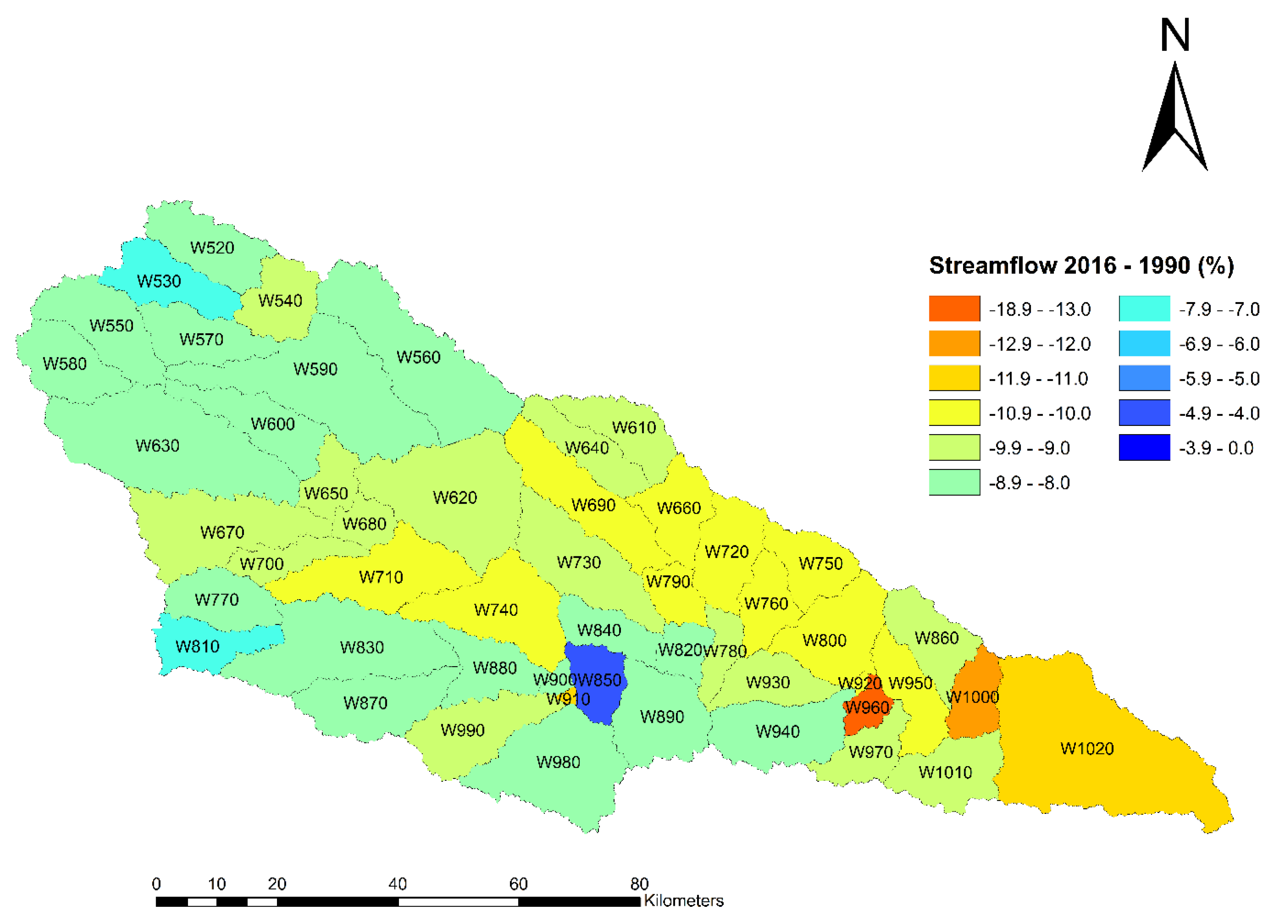

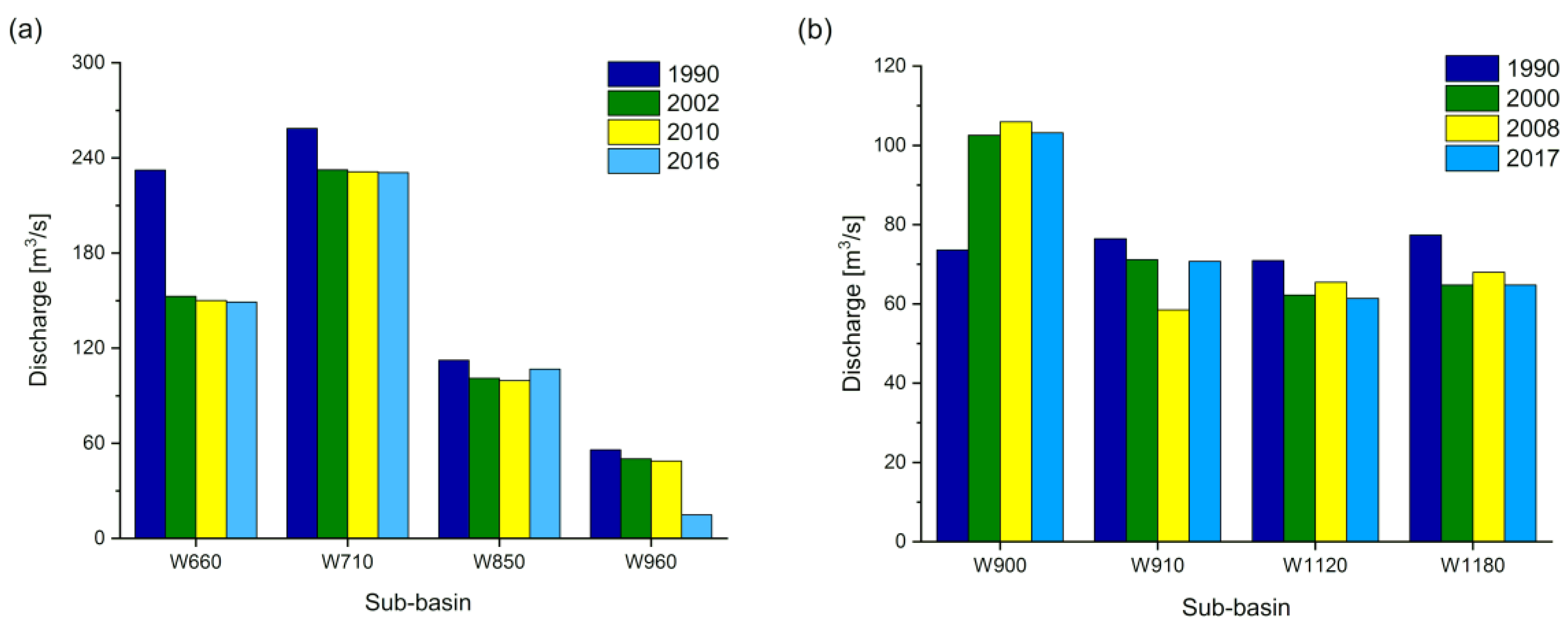
| LULC Type | Curve Numbers for Hydrologic Soil Group | |||
|---|---|---|---|---|
| A | B | C | D | |
| Agriculture | 67 | 78 | 85 | 89 |
| Urban | 77 | 85 | 90 | 92 |
| Grassland | 39 | 61 | 74 | 80 |
| Forest | 32 | 58 | 72 | 79 |
| Water | 98 | 98 | 98 | 98 |
| LULC Type | Land Use Land Cover Area (%) | Changes in Land Use Land Cover (%) | ||||||
|---|---|---|---|---|---|---|---|---|
| 1990 | 2002 | 2010 | 2016 | 1990–2002 | 2000–2010 | 2008–2016 | 1990–2016 | |
| Agriculture | 58.39 | 51.88 | 37.61 | 27.68 | −6.51 | −14.27 | −9.93 | −30.71 |
| Urban | 0.20 | 0.94 | 1.25 | 1.80 | 0.74 | 0.31 | 0.54 | 1.6 |
| Forest | 9.37 | 12.10 | 18.50 | 26.48 | 2.73 | 6.40 | 7.98 | 17.11 |
| Grassland | 31.90 | 34.95 | 42.52 | 43.91 | 3.05 | 7.57 | 1.39 | 12.01 |
| Water | 0.14 | 0.13 | 0.12 | 0.13 | −0.01 | −0.01 | 0.01 | −0.01 |
| Total | 100 | 100 | 100 | 100 | 0 | 0 | 0 | 0 |
| LULC Type | Land Use Land Cover Area (%) | Changes in Land Use Land Cover (%) | ||||||
|---|---|---|---|---|---|---|---|---|
| 1990 | 2000 | 2008 | 2017 | 1990–2000 | 2000–2008 | 2008–2017 | 1990–2017 | |
| Agriculture | 56.55 | 37.57 | 39.18 | 32.81 | −18.98 | 1.61 | −6.37 | −23.74 |
| Urban | 1.06 | 3.55 | 7.88 | 9.16 | 2.49 | 4.33 | 1.28 | 8.1 |
| Forest | 41.98 | 58.47 | 52.92 | 57.67 | 16.49 | −5.55 | 4.75 | 15.69 |
| Water | 0.41 | 0.40 | 0.02 | 0.36 | −0.01 | −0.38 | 0.34 | −0.05 |
| Total | 100 | 100 | 100 | 100 | 0 | 0 | 0 | 0 |
| Yanhe Catchment | Guangyuan Catchment | ||||
|---|---|---|---|---|---|
| LULC Changes Scenario | Flood Peak Discharge (m3/s) per Scenario | Relative Change (%) | LULC Changes Scenario | Flood Peak Discharge (m3/s) per Scenario | Relative Change (%) |
| Scenario S1 (1990LULC) | 4865.8 | ˗ | Scenario S1 (1990LULC) | 1512.7 | ˗ |
| Scenario S2 (2002LULC) | 4195.3 | −13.7 | Scenario S2 (2000LULC) | 1399.7 | −7.4 |
| Scenario S3 (2008LULC) | 4144.9 | −14 | Scenario S3 (2010LULC) | 1458.5 | −3.5 |
| Scenario S4 (2016LULC) | 4167.4 | −14.3 | Scenario S4 (2017LULC) | 1418.3 | −6.2 |
© 2020 by the authors. Licensee MDPI, Basel, Switzerland. This article is an open access article distributed under the terms and conditions of the Creative Commons Attribution (CC BY) license (http://creativecommons.org/licenses/by/4.0/).
Share and Cite
Kabeja, C.; Li, R.; Guo, J.; Rwatangabo, D.E.R.; Manyifika, M.; Gao, Z.; Wang, Y.; Zhang, Y. The Impact of Reforestation Induced Land Cover Change (1990–2017) on Flood Peak Discharge Using HEC-HMS Hydrological Model and Satellite Observations: A Study in Two Mountain Basins, China. Water 2020, 12, 1347. https://doi.org/10.3390/w12051347
Kabeja C, Li R, Guo J, Rwatangabo DER, Manyifika M, Gao Z, Wang Y, Zhang Y. The Impact of Reforestation Induced Land Cover Change (1990–2017) on Flood Peak Discharge Using HEC-HMS Hydrological Model and Satellite Observations: A Study in Two Mountain Basins, China. Water. 2020; 12(5):1347. https://doi.org/10.3390/w12051347
Chicago/Turabian StyleKabeja, Crispin, Rui Li, Jianping Guo, Digne Edmond Rwabuhungu Rwatangabo, Marc Manyifika, Zongting Gao, Yipu Wang, and Yuxiang Zhang. 2020. "The Impact of Reforestation Induced Land Cover Change (1990–2017) on Flood Peak Discharge Using HEC-HMS Hydrological Model and Satellite Observations: A Study in Two Mountain Basins, China" Water 12, no. 5: 1347. https://doi.org/10.3390/w12051347
APA StyleKabeja, C., Li, R., Guo, J., Rwatangabo, D. E. R., Manyifika, M., Gao, Z., Wang, Y., & Zhang, Y. (2020). The Impact of Reforestation Induced Land Cover Change (1990–2017) on Flood Peak Discharge Using HEC-HMS Hydrological Model and Satellite Observations: A Study in Two Mountain Basins, China. Water, 12(5), 1347. https://doi.org/10.3390/w12051347


