Environmental Land Use Conflicts in a Macroscale River Basin: A Preliminary Study Based on the Ruggedness Number
Abstract
:1. Introduction
2. Materials and Methods
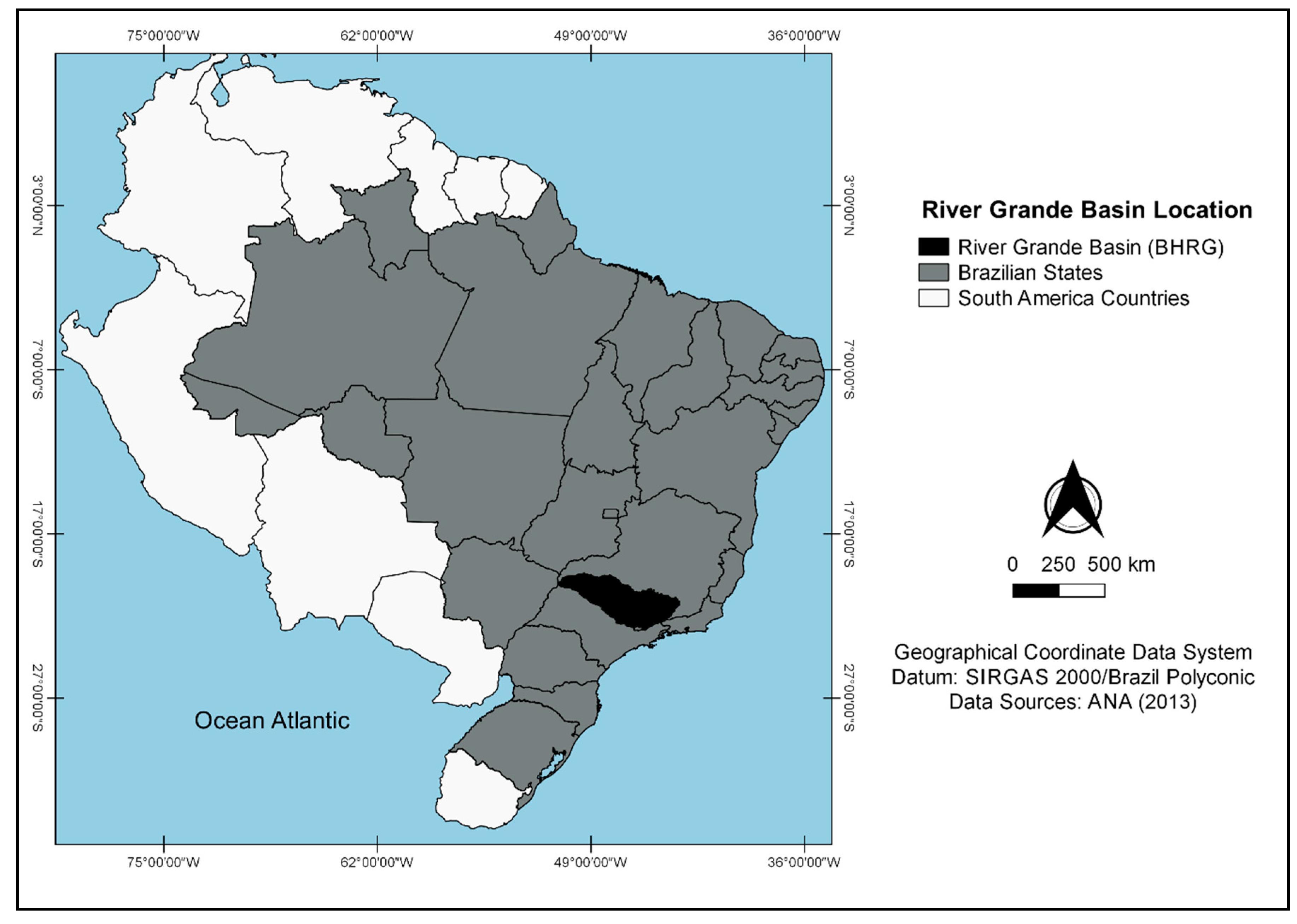
2.1. Study Area
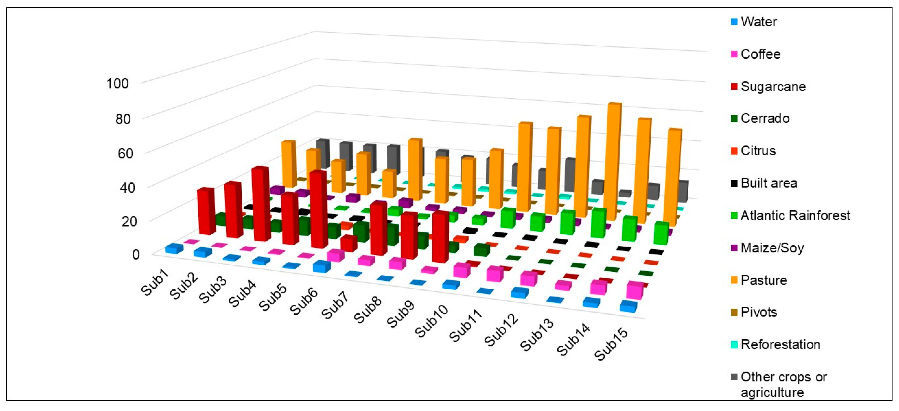
2.2. Data Processing
2.3. Morphometric Characterization
- Dd = Drainage density, km·km−2;
- ∑CT = Total length of watercourses, km;
- A = Sub-basin Contribution Area, km2;
- Ms = Mean slope, %;
- Δh = Equidistance between contours, km;
- ∑LCN = Total length of contour lines, km;
- RN = Ruggedness number (dimensionless).
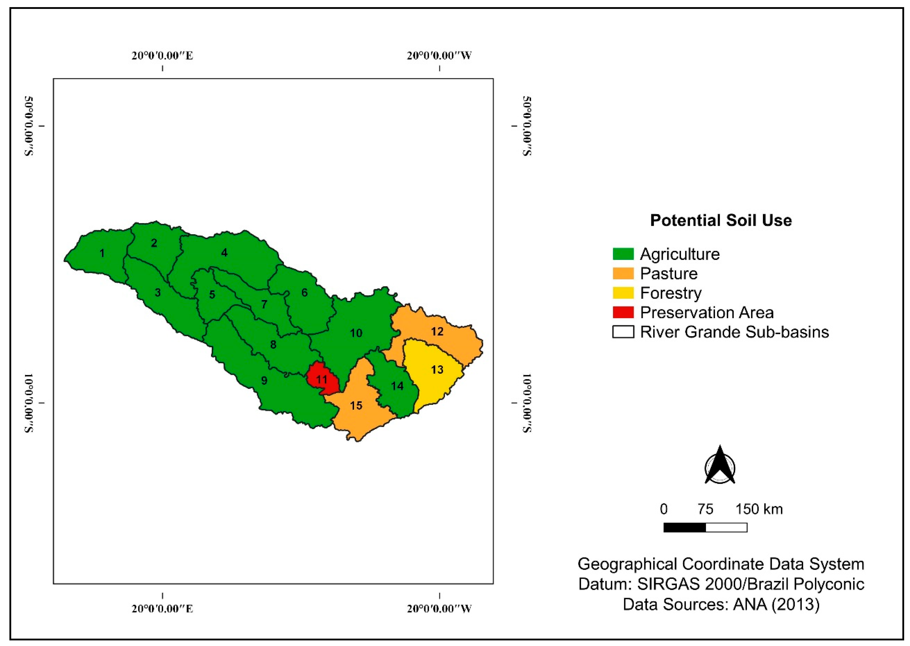
2.4. Determination of Environmental Land Use Conflict Areas
- areas without conflict are characterized by X − (A, B, C or D) ≤ 0, where the zero value does not represent conflict (an exact correspondence with natural use), while negative values represent areas where agriculture expansion is sustainable;
- conflict areas are characterized by X − (A, B, C or D) > 0 e X − (A, B, C or D) ≤ 3.
3. Results and Discussion
4. Conclusions
Supplementary Materials
Author Contributions
Funding
Acknowledgments
Conflicts of Interest
References
- Valle Júnior, R.F.; Galbiatti, J.A.; Pissarra, T.C.T. Diagnosis of conflict of land use and occupancy of river basin Uberaba. Glob. Sci. Technol. 2013, 6, 40–52. [Google Scholar]
- Valera, C.A.; Valle Júnior, R.F.; Varandas, S.G.P.; Sanches Fernandes, L.F.; Pacheco, F.A.L. The role of environmental land use conflicts in soil fertility: A study on the Uberaba River basin, Brazil. Sci. Total Environ. 2016, 562, 463–473. [Google Scholar] [CrossRef]
- Costa, R.C.A.; Pereira, G.T.; Pissarra, T.C.T.; Siqueira, D.S.; Fernandes, L.F.S.; Vasconcelos, V.; Fernandes, L.A.; Pacheco, F.A.L. Land capability of multiple-landform watersheds with environmental land use conflict. Land Use Policy 2019, 81, 689–704. [Google Scholar] [CrossRef]
- Siqueira, H.E.; Guidolini, J.F.; Antunes, D.H.; Oliveira, F.P.; Valle Júnior, R.F. Diagnóstico da qualidade da água em área de conflito de uso do solo na microbacia Mangabeira, Uberaba-MG. Enciclopédia Biosf. 2012, 8, 1164–1178. [Google Scholar]
- Pacheco, F.A.L.; Sanches Fernandes, L.F.; Valle Júnior, R.F.; Valera, C.A.; Pissarra, T.C.T. Land degradation: Multiple environmental consequences and routes to neutrality. Curr. Opin. Environ. Sci. Health 2018, 5, 79–86. [Google Scholar] [CrossRef]
- Oliveira, L.F.C.; Calil, P.M.; Rodrigues, C.; Kliemann, H.J.; Oliveira, V.A. Potencial do uso dos solos da bacia hidrográfica do alto rio Meia Ponte, Goiás. Ambient Água. 2013, 8, 222–238. [Google Scholar]
- Lima, W. Hidrologia Florestal Aplicada ao Manejo de Bacias Hidrográficas, 2nd ed.; Departamento de Engenharia Florestal, ESALQ-USP: Piracicaba, Brazil, 2008; p. 242. [Google Scholar]
- Feick, R.D.; Hall, G.B. Balancing consensus and conflict with a GIS-based multi-participant, multi-criteria decision support tool. GeoJournal 2002, 53, 391–406. [Google Scholar] [CrossRef]
- Koontz, T.M. We Finished the Plan, So Now What? Impacts of Collaborative Stakeholder Participation on Land Use Policy. Policy Stud. J. 2005, 33, 459–481. [Google Scholar] [CrossRef]
- Zhang, Y.J.; Li, A.J.; Fung, T. Using GIS and Multi-criteria Decision Analysis for Conflict Resolution in Land Use Planning. Procedia Environ. Sci. 2012, 13, 2264–2273. [Google Scholar] [CrossRef] [Green Version]
- Rocha, J.S.M.; Kurtz, S.M.J.M. Manual de Manejo Integrado de Bacias Hidrográficas, 1st ed.; Editora da UFSM: Santa Maria, Brazil, 2001; p. 282. [Google Scholar]
- Strahler, A.N. Hypsometric (area-altitude) analysis of erosional topography. Geol Soc. Am. Bull. 1952, 63, 1117–1142. [Google Scholar] [CrossRef]
- Baracuhy, J.G.V.; Kurtz, S.M.J.M.; Kurtz, F.C.; Duarte, S.M.A.; Lima, V.L.A.; Rocha, J.S.M.; Dantas Neto, J. Deterioração físico-conservacionista da microbacia hidrográfica do riacho Paus Brancos, Campina Grande, PB. Rev. Bras. Eng Agríc Ambient. 2003, 7, 159–164. [Google Scholar] [CrossRef]
- Sampaio, M.V.; Santos, M.F.; Rocha, J.S.M.; Paula, M.D.; Mendes, A.V. Deterioração Físico—Conservacionista da Sub—Bacia Hidrográfica do Rio Ibicuí—Mirim—RS. Cienc Agrotec. 2010, 34, 300–306. [Google Scholar] [CrossRef]
- Rodrigues, V.S.; Valle Júnior, R.F.; Sanches Fernandes, L.F.; Pacheco, F.A.L. The assessment of water erosion using Partial Least Squares-Path Modeling: A study in a legally protected area with environmental land use conflicts. Sci. Total Environ. 2019, 691, 1225–1241. [Google Scholar] [CrossRef]
- Pacheco, F.A.L.; Varandas, S.G.P.; Sanches Fernandes, L.S.; Valle Júnior, R.F. Soil losses in rural watersheds with environmental land use conflicts. Sci. Total Environ. 2014, 485–486, 110–120. [Google Scholar] [CrossRef]
- Valle Júnior, R.F.; Varandas, S.G.P.; Sanches Fernandes, L.S.; Pacheco, F.A.L. Environmental land use conflicts: A threat to soil conservation. Land Policy 2014, 41, 172–185. [Google Scholar] [CrossRef]
- Valle Júnior, R.F.; Varandas, S.G.P.; Pacheco, F.A.L.; Pereira, V.R.; Santos, C.F.; Cortes, M.R.V.; Sanches Fernandes, L.S. Impacts of land use conflicts on riverine ecosystems. Land Policy 2015, 43, 48–62. [Google Scholar] [CrossRef] [Green Version]
- Pacheco, F.A.L.; Sanches Fernandes, L.S. Environmental land use conflicts in catchments: A major cause of amplified nitrate in river water. Sci. Total Environ. 2016, 548–549, 173–188. [Google Scholar] [CrossRef]
- Valle Júnior, R.F.; Abdala, V.L.; Val, B.H.P.; Carmo, D.A.; Souza, M.A.C. Diagnóstico do uso potencial do solo e conflitos ambiental na microbacia hidrográfica do rio Veríssimo, Veríssimo-MG. Enciclopédia Biosf. 2011, 7, 1–10. [Google Scholar]
- Guidolini, J.F.; Giarolla, A.; Toledo, P.M.; Valera, C.A.; Ometto, J.P.H.B. Water Sustainability at the River Grande Basin, Brazil: An Approach Based on the Barometer of Sustainability. Int. J. Environ. Res. Public Health 2018, 15, 2582. [Google Scholar] [CrossRef] [Green Version]
- Legal Basis for Water Resources Management in Brazil: Case Study of the Rio Grande Basin. Available online: https://publications.waset.org/10008902/legal-basis-for-water-resources-management-in-brazil-case-study-of-the-rio-grande-basin (accessed on 28 January 2020).
- Agência Nacional de Águas (Brazilian National Water Agency)—ANA. Produto Parcial (PP02): Diagnóstico da bacia hidrográfica do Rio Grande; Agência Nacional de Águas (Brazilian National Water Agency)—ANA: Brasília, Brazil, 2016; p. 553. [Google Scholar]
- Agência Nacional de Águas (Brazilian National Water Agency)—ANA. Qualidade da Água Da bacia do Rio Grande; Agência Nacional de Águas (Brazilian National Water Agency)—ANA: Brasília, Brazil, 2013; p. 58. [Google Scholar]
- Empresa Brasileira de Pesquisa Agropecuária—Embrapa. Súmula da X Reunião Técnica de Levantamento de Solos; Empresa Brasileira de Pesquisa Agropecuária—Embrapa: Brasília, Brazil, 1979; p. 83. [Google Scholar]
- Silva, V.A.; Oliveira, L.T.; Estevam, J.P.S.; Siqueira, H.E.; Valle Júnior, R.F. Análise morfométrica e definição do potencial de uso do solo da microbacia do córrego Neca, em Uberaba-MG. Fazu Em Rev. 2013, 10, 13–16. [Google Scholar]
- Christofoletti, A. Geomorfologia, 2nd ed.; Edgar Blucher: São Paulo, Brazil, 1980; p. 190. [Google Scholar]
- Valle Júnior, R.F. Diagnóstico de áreas de risco de erosão e conflitos de uso dos solos na bacia do rio Uberaba. Ph.D. Thesis, Universidade Estadual Paulista, Jaboticabal, SP, Brazil, 2008. [Google Scholar]
- Strahler, A.N. Quantitative analisys of watershed geomorphology. Trans. Am. Geophys. Union 1957, 38, 913–920. [Google Scholar] [CrossRef] [Green Version]
- Hiruma, S.T.; Ponçano, W.L. Densidade de drenagem e sua relação com fatores geomorfopedológicos na área do Alto Rio Pardo, SP e MG. Rev. Inst. Geológico. 1994, 15, 49–57. [Google Scholar]
- Horton, R.E. Erosional development of streams and their drainage basins, hydrophyrical approach to quantitative morphology. J. Jpn. For. Soc. 1955, 37, 257–262. [Google Scholar]
- Empresa Brasileira de Pesquisa Agropecuária—Embrapa. Sistema Brasileiro de Classificação de Solos; Empresa Brasileira de Pesquisa Agropecuária—Embrapa: Brasilia, Brazil, 2018; p. 355. [Google Scholar]
- Valera, C.A.; Pissarra, T.C.T.; Martins Filho, M.V.; Valle Júnior, R.F.; Sanches Fernandes, L.F.; Pacheco, F.A.L. A legal framework with scientific basis for applying the ‘polluter pays principle’ to soil conservation in rural watersheds in Brazil. Land Use Policy 2017, 66, 61–71. [Google Scholar] [CrossRef] [Green Version]
- Valera, C.A.; Pissarra, T.C.T.; Martins Filho, M.V.; Valle Júnior, R.F.; Oliveira, C.F.; Moura, J.P.; Sanches Fernandes, L.F.; Pacheco, F.A.L. The Buffer Capacity of Riparian Vegetation to Control Water Quality in Anthropogenic Catchments from a Legally Protected Area: A Critical View over the Brazilian New Forest Code. Water 2019, 11, 549. [Google Scholar] [CrossRef] [Green Version]


| RN and X | Ranking |
|---|---|
| Agriculture (Class A) | 1 |
| Pasture (Class B) | 2 |
| Forestry (Class C) | 3 |
| Preservation (Class D) | 4 |
| Environmental Land Use Conflict Classes | RN − Actual Land Use |
|---|---|
| Class 1 | (Preservation) 4 − 3 (Forestry) |
| (Forestry) 3 − 2 (Pasture) | |
| (Pasture) 2 − 1 (Agriculture) | |
| Class 2 | (Preservation) 4 − 2 (Pasture) |
| (Forestry) 3 − 1 (Agriculture) | |
| Class 3 | (Preservation) 4 − 1 (Agriculture) |
| Ord | A | P | LMC | Lax | TL | TLLC * | Hmax | Hmin | Dd | Ms | RN | |
|---|---|---|---|---|---|---|---|---|---|---|---|---|
| Sub1 | 3 | 8017.14 | 412.81 | 117.20 | 126.06 | 989.68 | 1,365,461.00 | 642 | 312 | 0.12 | 0.51 | 0.06 |
| Sub2 | 4 | 7033.69 | 424.21 | 112.27 | 108.89 | 127.10 | 13,279,508.92 | 776 | 367 | 0.02 | 5.66 | 0.10 |
| Sub3 | 4 | 9956.64 | 548.70 | 180.84 | 210.77 | 1198.98 | 18,397,600.03 | 762 | 371 | 0.12 | 5.54 | 0.67 |
| Sub4 | 4 | 15,088.49 | 737.43 | 231.73 | 195.56 | 1879.99 | 32,391,461.88 | 1226 | 413 | 0.12 | 6.44 | 0.80 |
| Sub5 | 4 | 5203.95 | 418.56 | 93.04 | 124.94 | 782.09 | 6,777,040.61 | 870 | 441 | 0.15 | 3.91 | 0.59 |
| Sub6 | 4 | 9205.83 | 479.46 | 162.22 | 151.04 | 1448.16 | 40,627,430.84 | 1443 | 620 | 0.16 | 13.24 | 2.08 |
| Sub7 | 3 | 6753.08 | 539.97 | 302.74 | 208.79 | 1620.00 | 17,332,246.04 | 1282 | 460 | 0.24 | 7.70 | 1.85 |
| Sub8 | 3 | 10,351.18 | 623.38 | 355.89 | 198.50 | 3075.60 | 34,318,554.71 | 1559 | 482 | 0.30 | 9.95 | 2.96 |
| Sub9 | 3 | 17,906.59 | 887.35 | 460.76 | 307.23 | 4115.60 | 56,881,875.18 | 1687 | 483 | 0.23 | 9.53 | 2.19 |
| Sub10 | 4 | 16,209.60 | 840.17 | 285.19 | 195.01 | 1703.63 | 70,951,231.85 | 1478 | 729 | 0.11 | 13.13 | 1.38 |
| Sub11 | 4 | 2427.81 | 258.24 | 107.06 | 77.40 | 1987.18 | 14,673,057.56 | 1796 | 858 | 0.82 | 18.13 | 14.84 |
| Sub12 | 3 | 10,605.79 | 795.62 | 215.34 | 191.78 | 3614.31 | 50,946,273.42 | 1495 | 749 | 0.34 | 14.41 | 4.91 |
| Sub13 | 4 | 8905.73 | 505.87 | 202.77 | 130.74 | 5493.06 | 49,287,576.49 | 2647 | 796 | 0.62 | 16.60 | 10.24 |
| Sub14 | 3 | 6964.31 | 515.19 | 240.39 | 141.59 | 1266.04 | 46,198,627.29 | 2754 | 753 | 0.18 | 19.90 | 3.62 |
| Sub15 | 4 | 9630.04 | 651.35 | 274.02 | 154.35 | 2231.30 | 69,476,708.56 | 2228 | 755 | 0.23 | 21.64 | 5.01 |
| Soil Capability | RN Class Thresholds |
|---|---|
| Agriculture | 0.06 to 3.76 |
| Pasture | 3.77 to 7.47 |
| Forestry | 7.48 to 11.18 |
| Preservation | 11.19 to 14.86 |
| Sub-Basins | Amounts of Soil Types in Rio Grande Sub-Basins | |||||||||
|---|---|---|---|---|---|---|---|---|---|---|
| Water | PVA | CX | LVA | RL | RQ | NV | OY | PV | LV | |
| Sub1 | 10.61 | 10.87 | __ | __ | __ | __ | __ | __ | 34.11 | 44.41 |
| Sub2 | 6.25 | __ | __ | __ | __ | __ | __ | __ | 21.06 | 72.70 |
| Sub3 | 0.69 | 83.06 | __ | __ | __ | __ | __ | __ | __ | 16.25 |
| Sub4 | 5.43 | 9.37 | 0.35 | 10.91 | __ | __ | 0.03 | __ | 3.83 | 70.08 |
| Sub5 | __ | 3.41 | __ | 1.48 | __ | __ | __ | __ | __ | 95.11 |
| Sub6 | 3.16 | 0.86 | 5.21 | 18.33 | 17.12 | __ | __ | __ | __ | 55.32 |
| Sub7 | 0.17 | 0.06 | __ | 16.89 | __ | 7.83 | __ | __ | __ | 75.06 |
| Sub8 | __ | 32.12 | 0.72 | 12.19 | __ | 8.11 | __ | __ | __ | 46.85 |
| Sub9 | __ | 23.63 | 3.12 | 11.69 | __ | __ | __ | 2.56 | 0.00 | 59.01 |
| Sub10 | 9.26 | 16.42 | 20.55 | 5.13 | 0.27 | __ | __ | __ | __ | 48.38 |
| Sub11 | __ | 18.19 | 70.02 | __ | __ | __ | __ | __ | __ | 11.79 |
| Sub12 | __ | 9.33 | 36.06 | 33.15 | __ | __ | __ | __ | __ | 21.46 |
| Sub13 | 1.29 | 0.75 | 93.04 | 0.00 | __ | __ | __ | __ | __ | 4.92 |
| Sub14 | __ | __ | 25.67 | 24.09 | __ | __ | __ | __ | __ | 50.24 |
| Sub15 | __ | 4.40 | 5.04 | 37.91 | __ | __ | __ | __ | __ | 52.65 |
| Actual Land Use | Soil Capability or Potential Land Use | |||
|---|---|---|---|---|
| Agriculture | Pasture | Forestry | Preservation | |
| Agriculture | Appropriate | Conflict 1 | Conflict 2 | Conflict 3 |
| Pasture | Acceptable | Appropriate | Conflict 1 | Conflict 2 |
| Forestry | Acceptable | Acceptable | Appropriate | Conflict 1 |
| Preservation | Acceptable | Acceptable | Acceptable | Appropriate |
| Built areas | Conflict | Conflict | Conflict | Conflict |
| Water | Acceptable | Acceptable | Acceptable | Acceptable |
© 2020 by the authors. Licensee MDPI, Basel, Switzerland. This article is an open access article distributed under the terms and conditions of the Creative Commons Attribution (CC BY) license (http://creativecommons.org/licenses/by/4.0/).
Share and Cite
Guidolini, J.; Ometto, J.; Arcoverde, G.; Giarolla, A. Environmental Land Use Conflicts in a Macroscale River Basin: A Preliminary Study Based on the Ruggedness Number. Water 2020, 12, 1222. https://doi.org/10.3390/w12051222
Guidolini J, Ometto J, Arcoverde G, Giarolla A. Environmental Land Use Conflicts in a Macroscale River Basin: A Preliminary Study Based on the Ruggedness Number. Water. 2020; 12(5):1222. https://doi.org/10.3390/w12051222
Chicago/Turabian StyleGuidolini, Janaína, Jean Ometto, Gustavo Arcoverde, and Angélica Giarolla. 2020. "Environmental Land Use Conflicts in a Macroscale River Basin: A Preliminary Study Based on the Ruggedness Number" Water 12, no. 5: 1222. https://doi.org/10.3390/w12051222
APA StyleGuidolini, J., Ometto, J., Arcoverde, G., & Giarolla, A. (2020). Environmental Land Use Conflicts in a Macroscale River Basin: A Preliminary Study Based on the Ruggedness Number. Water, 12(5), 1222. https://doi.org/10.3390/w12051222


