1. Introduction
Poorly planned land use is a major erosion accelerator and environmental degradation cause [
1]. Poor planning impacts influence physical quality and soil fertility, agricultural productivity, water quality and availability, biodiversity and other ecosystem services [
2]. Inadequate land planning and misuse leads to annual productivity losses, reaching approximately seven million hectares of agricultural land in various regions worldwide. In financial terms, these losses represent US
$70 per inhabitant, according to the United Nations Food and Agriculture Organization (FAO) [
3].
In some areas, current land use is not consistent with soil potential use or soil capability. When this occurs, the area is termed as being in environmental land use conflict. The concept of environmental land use conflict encompasses two specific situations: (1) land use is above its capability or (2) soil is underestimated, leading to low productivity [
1,
4,
5]. Land misuse is the precursor to environmental land use conflicts. Therefore, understanding land capability is essential to plan and optimize its use with the implementation of joint soil conservation techniques [
6]. It is understood that soil capacity, natural use or potential use is the planned and conscious use of soil, considering its natural characteristics. Furthermore, this does not accelerate or amplify erosive processes and maintains, with minimal losses, its physical, chemical and microbiological integrity characteristics [
2,
3]
The ideal work unit for land capability studies are watersheds, as natural processes can be associated to anthropic actions in these areas [
6,
7]. In order to optimize land use planning, various methods to determine soil capability have been developed [
8,
9,
10], that evolved with the emergence of geographic information systems (GIS) Nevertheless, none of these models were designed to determine land use based on their soil capability [
3]. One exception was the [
11] model, based on the ruggedness number (RN).
The RN was introduced by [
12] as a variable related to slope and drainage density in watersheds. The RN-based land use potential determination model establishes a relationship between soil capability, drainage density (Dd) and mean slope (Ms). The Ruggedness Number indicates the reality of sub-basin watersheds and offers a simple, quick contribution and precise planning, for better and more just economic exploitation, according to land aptitude. Soil capability in river basins and the Ruggedness Number are equivalent in over 95% of cases [
13,
14]. The higher the RN value, the greater the danger of erosion and environmental degradation [
15]. In addition to providing a direct assessment of soil capability, the RN model effectively articulates with the conflict theory proposed by Ref. [
1]. This theory assesses the environmental impacts generated by inappropriate land use. However, the RN-based model may display reduced effectiveness as a function of the size of the basin’s contributing area. Due to heterogeneity, Ms and Dd may be insufficient to determine potential land use in large river basins [
3]. In such cases, basin compartmentalization is recommended.
Many studies have demonstrated the efficiency of the RN method for determining soil capability in Brazilian watersheds [
1,
2,
3,
4,
5,
6,
7,
13,
14,
15] and other watersheds around the world [
16,
17,
18,
19]. However, the absence of potential land use or agricultural land suitability assessments is recurrent in territorial management plans and integrated water resources plans (IWRP). The situation is critical, as these plans include information on management actions, projects, works and priority investments that disregard local soil capability.
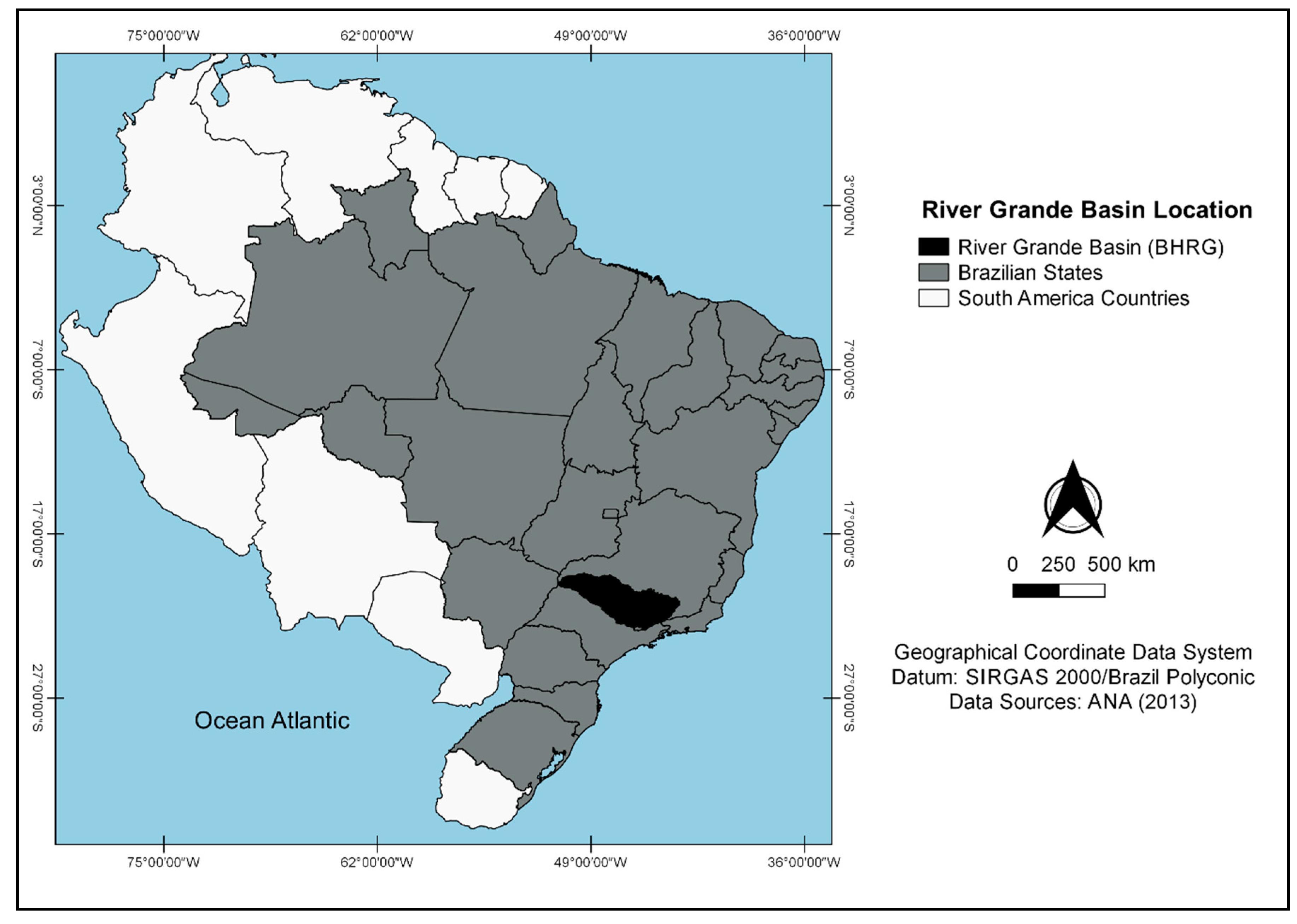
In this context, the aim of this preliminary study is to identify possible environmental land use conflicts at the Rio Grande Basin (BHRG), Brazil, using the Ruggedness Number [
11,
20]. The methodology can be easily replicated to other macroscale river basins. The results presented in this research may support territorial planning and the elaboration of integrated water resources plans of river basins.
3. Results and Discussion
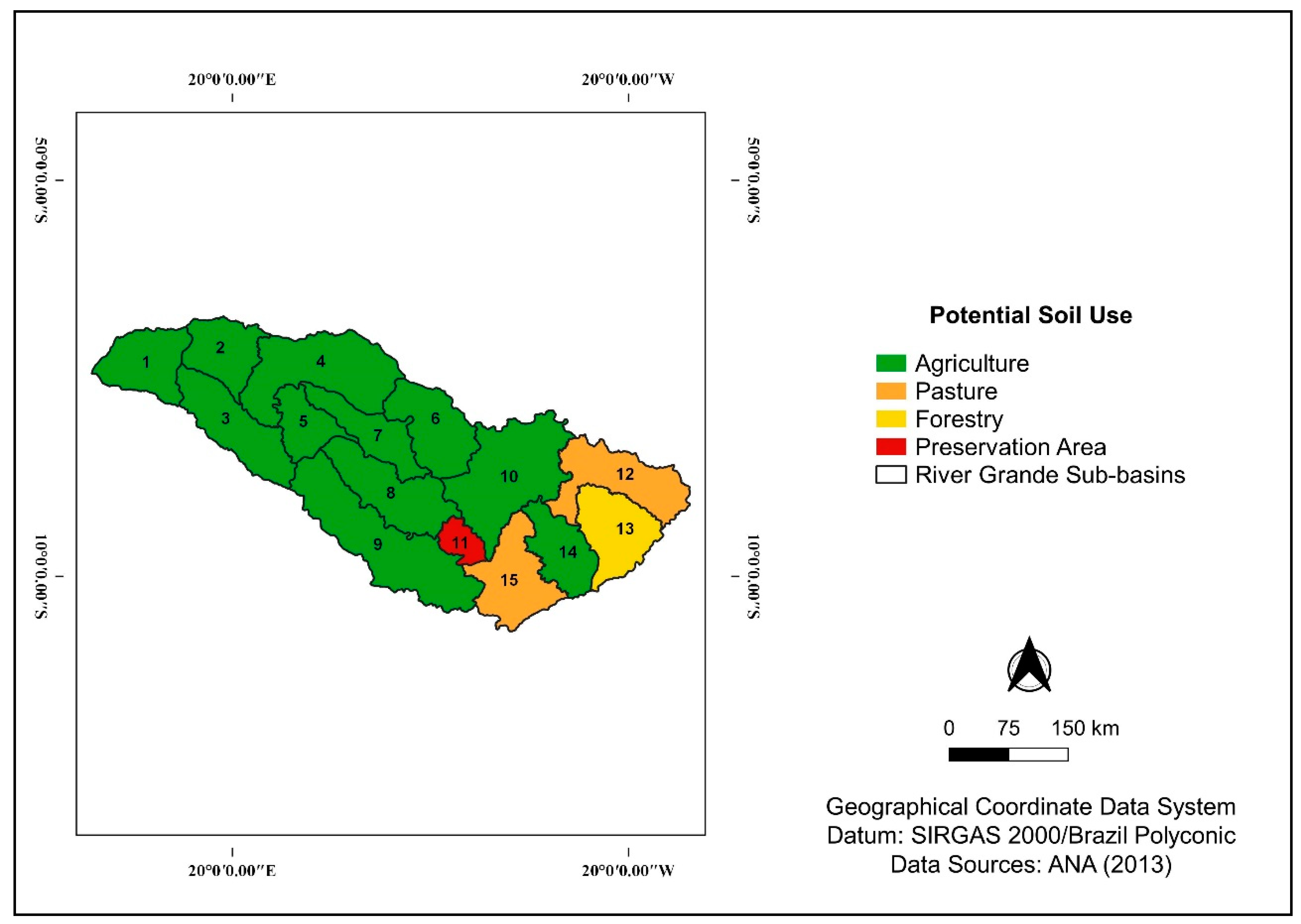
To identify soil capability, the ruggedness number (RN) was calculated from the morphometric characteristics of the sub-basins. The results indicate that 73.3% of the sub-basins have potential for agricultural use, 13.3% display potential for pasture use and 12.4% of the sub-basins display the potential for reforestation or preservation. Soil has been used both correctly and/or acceptably in much of the BHRG, but conflicts of use are still noted.
Knowledge on land use along with the morphometric characterization of a watershed facilitates the assessment of possible ecosystem disturbances effect and contribute to the proper planning of anthropogenic exploitation [
6].
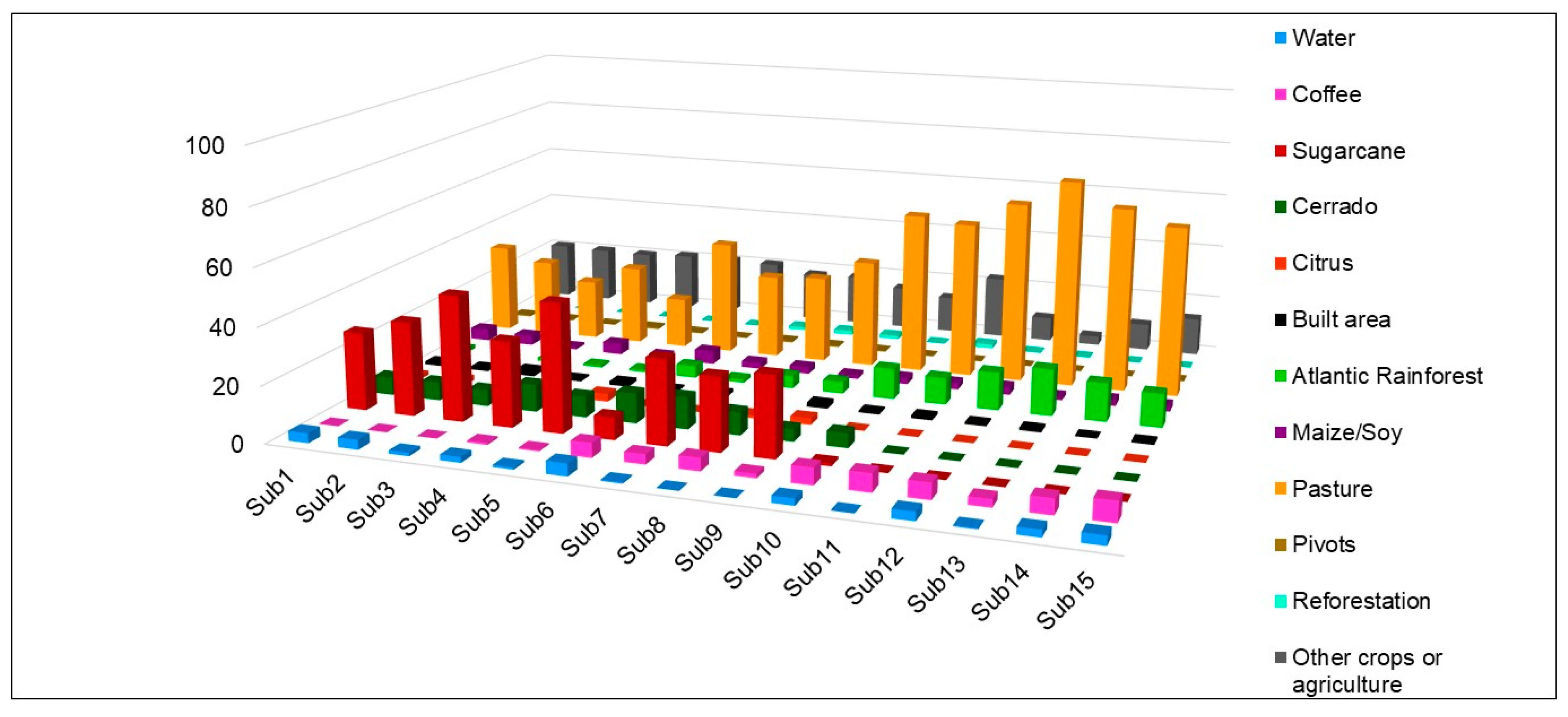
Figure 3 and
Table 3 indicate the actual land class distribution areas and morphometric characterization for the Rio Grande sub-basins, respectively.
The predominance of pasture and sugarcane is noted at the BHRG. In addition, sugarcane cultivation is notorious in flat to smooth undulating sub-basins, while pastures predominate in more rugged sub-basins. The altimetric amplitude (Hmax–Hmin) is high and the drainage density (Dd) was considered low in all sub-basins. The hierarchy of the river network (Ord) ranged from third to fourth order [
29] and the mean slope (Ms) ranged from 0.51% (flat) to 21.64% (wavy) [
25], between the sub-basins. It is important to highlight that the slope is a limiting factor concerning agricultural production and is related to the tolerable intensity of land use.
As mentioned earlier, low Dd values are associated with permeable rock and rainfall regions characterized by low rainfall rates [
7]. Ref. [
30] studied the relationship between drainage density and geomorphological and pedological factors in the Alto Rio Pardo area (São Paulo State/Minas Gerais State), and concluded that low Dd values (<1.5 km·km
−2) are concentrated in oxisols in the peripheral depression, whose substrate is the sedimentary terrain of the Paraná Basin. Soils and permeable rocks on the soft topography terrain may have enabled the lowest runoff/infiltration ratio, resulting in low Dd values. When carrying out a morphometric characterization and the determination of the potential soil use for Uberaba River watersheds, Ref. [
1] corroborated that oxisols display lower drainage efficiency.
The environmental degradation risk in river basins is represented by the RN, calculated from the product between Dd and Ms. This coefficient allows for the identification of potential land use. In the present study, an RN range of 14.78 and class interval (I) = 3.70 were verified. Thus, the thresholds for each potential land use class are presented in
Table 4.
Most of the Rio Grande sub-basins display potential agricultural use (RN ranging from 0.06 to 3.76) (see
Table 4), which is consistent with the slightly rugged relief and the predominance of latosols [
7,
30,
31]. However, sub-basin 11 displays the potential use for preservation, while sub-basins 12 and 15 display capability for pasture use and sub-basin 13 displays capability for forestry. Ref. [
1] obtained similar results for the Uberaba River watershed, reporting that 47.12% of the Uberaba River watershed area displays potential for agricultural use. It is important to note that the Uberaba River microbasins are inserted in the BHRG.
Cambisols predominate in areas suitable for reforestation or preservation.
Figure 4 presents the potential land use for the assessed Rio Grande sub-basins and
Table 5 displays the amounts of soil types by sub-basin. Cambisols occur in a variety of environments, but are usually associated with rugged (undulating to hilly) relief areas. In steep environments, shallower cambisols limit agricultural production due to high susceptibility to erosion and difficult agricultural mechanization. In contrast, oxisols, predominant at the RGHB, display high potential for agricultural use due to their good physical condition and softer reliefs. Oxisol limitations are related to poor fertility and moisture retention when the texture is coarse and the weather is drier [
32].
Inadequate land use planning causes environmental land use conflicts [
6], which may occur in two situations: (1) the current land use contradicts the recommendation obtained from the RN and overestimates soil capability or (2) soil use is underestimated, displaying low productivity [
1]. In the present study, “acceptable use” areas are considered as those preserved with natural vegetation, areas with agricultural potential used for pasture and/or reforestation, areas with potential for pasture used for forestry and water. In addition, “conflict” comprises built areas (
Table 6).
Table 6 shows the appropriate and acceptable land uses and environmental land use conflicts in the Rio Grande sub-basins. In most sub-basins, appropriate and acceptable land use are predominant. However, sub-basin 11 is noteworthy as the sub-basin presenting the highest risk of environmental degradation at the BHRG (RN = 14.84—highest value), presenting class 1, 2 and 3 conflicts. Sub-basin 13 (RN = 10.24) presented class 1 and 2 conflicts and sub-basins 12 (RN = 4.91) and sub-basin 15 (RN = 5.01) presented class 1 and 2 conflicts, respectively. Suggesting that the soil is being used in an appropriate or acceptable way does not mean exemption from care in maintaining its physical, chemical and microbiological properties. The use of conservation techniques will imply the soil maintenance capability (
Table S1).
A worrying observation about land use at BHRG is the low proportion of preserved natural vegetation, especially in areas presenting a flat or smooth undulating relief. This suggests a possible deficit in permanent preservation and legal reserve areas due to agricultural expansion in the basin. The relevance of natural vegetation for maintaining water quality and availability and in soil conservation is well known. Thus, we consider natural vegetation preservation as paramount, and their presence at BHRG is acceptable (and recommended) regardless of RN values.
There exists general recommendations and non-categorical actions for each class of environmental land use conflict. In class 1 conflict areas, severe or permanent risks/limitations are noted when land is used for annual crop and pasture cultivation. Thus, the joint implementation of soil conservation techniques, especially displaying both a vegetative and mechanical character, is essential. In class 2 conflict areas, forestry or preservation are recommended, as class 2 conflict areas are unsuitable for intensive agriculture. Finally, for class 3 conflict areas, preservation is recommended, as these areas are unsuitable for agriculture or grazing. It is noteworthy that recommendations are not followed in some Rio Grande sub-basins [
17,
18,
28].
Sub-basin 11, in particular, should be preserved. However, over 90% of its area is used for agriculture, pasture, forestry or building and less than 10% is preserved. With a predominance of cambisols (70% of the total area) and an undulating relief, its susceptibility to erosion is high [
32]. Cambisols also predominate in sub-basin 13, with potential use for forestry, where class 1 and 2 conflicts were observed, the relief is undulating and less than 17% of the total area is preserved.
Soil loss through erosion is the main impact caused by environmental land use conflicts. Consequently, decreased agricultural productivity and soil organic matter, nutrient leaching, deterioration of surface and groundwater quality and decreased biodiversity, as well as other damages to the provided ecosystem services are observed [
2,
3].
Currently, few countries in the world have established technical and legal criteria for land use, occupation and conservation. The “polluter pays principle” is an exception in force in Brazil that warns of the legal and social responsibility of soil conservation [
33]. According to this principle, the landowner must mitigate or even remediate environmental impacts as a result of unsustainable practices [
3]. Permanent Preservation Areas (PPAs), pursuant to articles 4, 5 and 6 of Law No. 12,651/12 (New Forest Code), are defined as: “protected areas, covered or not by native vegetation, with the environmental function of preserving water resources, landscape, geological stability and biodiversity, facilitating the gene flow of fauna and flora, protecting the soil and ensuring the well-being of human populations” [
34].
Considering the low amounts of natural vegetation preserved at the BHRG, especially in sub-basins suitable for agricultural production, we can infer that PPA boundaries are not in line with the legislation (which provides for at least 30 m in width). In addition, Ref. [
33] concluded that 30 m wide PPA strips are insufficient for maintaining water quality.
The strength of this study is the advancement of knowledge related to potential land use at the BHRG, as this is the first study that covers the whole basin. Determining the potential use for the Rio Grande sub-basins and identifying conflicting areas can support action planning, territorial management and integrated water management.
However, the major limitation of this study is the reduction in the effectiveness of the RN methodology with increasing catchment areas. Due to increased heterogeneity, Dd and Ms values may be insufficient to discriminate land use potential in large basins [
3].
In this preliminary study, the RN method was deemed efficient, especially because it discriminates potential uses, despite the low drainage density found in all sub-basins. When testing the method for the BHRG, without compartmentalizing the data in sub-basins, an RN of 0.92 was obtained. Low RN values suggest potential agricultural use [
11], the result would be less consistent with reality, although most assessed sub-basins display the potential for agriculture use.
The results indicate the enormous agricultural potential at the BHRG. However, it is important to highlight that socioeconomic development must be linked to environmental quality. This requires integrating water resources management with other public administration sectors that also affect water quality and availability [
21]. Land management, closely related to land use and occupation, must be adapted in accordance to environmental, social and development policies. Sustainability is the best approach to this end.
Future studies, including sustainability research, may use watershed-scale environmental land use conflicts as an indicator for soil degradation risks. To improve the effectiveness of the applied methodology, we suggest the refinement of the RN method by crossing soil, mean slope and roughness coefficient data [
6] or integrating relief variables (RN), relief shape (dissection) and soil properties (magnetic susceptibility) [
3], for example, to compare other data to our study. In addition, it is possible to compartmentalize sub-basins into smaller areas (microbasins) in GIS and develop required exhaustive studies on environmental quality (soil capability, water, biodiversity) at the BHRG, especially in environmental land use conflict areas.
In summary, our results suggest high agricultural potential at the BHRG and suggest the presence of class 1, 2 and 3 environmental land use conflicts. The low amounts of natural vegetation in the sub-basins indicate vegetation suppression due to agricultural expansion. In Brazil, environmental quality maintenance requires monitoring compliance with environmental laws and the effectiveness of the Polluter Pays Principle.
4. Conclusions
This preliminary study reports on the potential land use in the Rio Grande sub-basins and identified environmental land use conflicts area based on the morphometric variables Dd (drainage density), Ms (mean slope), and the Ruggedness Number.
Dd was low for all sub-basins (<0.5 km·km−2). The Ms, on the other hand, ranged from 0.51% (flat) to 21.64% (wavy). Regarding type of soils, latosols (in flatter reliefs) and cambisols (in more rugged reliefs) were the most noteworthy.
Overall, Rio Grande sub-basins display a high capability for agricultural use (73.3%). Sub-basins 12 and 15 showed capability for pasture use. Sub-basins 11 and 13 showed capability use for preservation and reforestation, respectively.
Class 1, 2 and 3 environmental land use conflicts were noted throughout the Rio Grande Basin. Sub-basins 11 and 13 were the most noteworthy in this regard, at 90.24% and 82.80% of conflicting areas in relation to the total sub-basin area, respectively.
Reporting that the soil is being used in an appropriate or acceptable way does not suggest the dispensability of using joint conservation techniques to maintain soil capacity.
The low proportion of natural vegetation in the sub-basins indicate vegetation suppression due to agricultural expansion. Thus, enforcement of compliance with environmental laws and the effectiveness of the Polluter Pays Principle becomes paramount.
The RN was effective in suggesting soil capability and environmental land use conflict areas in Rio Grande sub-basins. However, the effectiveness of this methodology may decrease if the contribution area of the sub-basin increases.
Given the relevance of the issue assessed herein, environmental land use conflicts can be used as soil degradation risk indicators in river basin sustainability surveys.
This preliminary study contributes to the advancement of knowledge related to environmental land use conflict at the BHRG, as it is the first study that covers the entire basin. Studying soil capability and identifying environmental land use conflict areas can support territorial management and integrated watershed management. We emphasize that this is an important preliminary study which may be carried out in any other macroscale hydrographic basin.


