Article

Location Suitability for Small Reservoirs at the Bodri-Kuto River Basin Based on Spatial Monthly SPI

by
Suharyanto Suharyanto
1,*,
Theresia Novie Secunda Harjanti
2,
Ignatius Sriyana
1 and
Fransiskus Suryadi
3
1
Department of Civil Engineering, Diponegoro University, Semarang 50274, Indonesia
2
Water Resources and Spatial Planning Office, Central Java, Semarang 50144, Indonesia
3
Senior Lecturer in Land and Water Development, Water Science Engineering, IHE, 2611 AX Delft, The Netherlands
*
Author to whom correspondence should be addressed.
Water 2020, 12(4), 993; https://doi.org/10.3390/w12040993
Submission received: 28 January 2020 / Revised: 12 March 2020 / Accepted: 14 March 2020 / Published: 1 April 2020
(This article belongs to the Section Water Use and Scarcity)

Abstract

:
Despite efforts to develop and conserve water resources, almost every year during the dry season, some areas in Central Java province in Indonesia still experience a lack of water, especially in rural villages. These areas require water supply via water trucks and/or portable pumps to obtain water from rivers and groundwater. The Central Java government committed to implementing a program involving the construction of 1000 small reservoirs by 2020 to overcome water shortages. However, the technically ideal sites are mostly privately owned, which requires lengthy and costly land acquisition. To avoid the uncertainty of land acquisition, some small reservoirs were placed on state-owned land, which did not require land acquisition. The consideration of putting more emphasis on state-owned land rather than technically ideal sites for the construction of small reservoirs raise the issue on the location suitability of those reservoirs. In this study, we evaluated the suitability of the location of small reservoirs in the Bodri-Kuto river basin using the monthly standardized precipitation index (SPI). We used rainfall records of 25 stations in the river basin from 2000 to 2016 and analyzed yearly and monthly rainfall data. The yearly analysis shows that the dry conditions (SPI < −0.5) from 2005 to 2009 affected more than half of the rainfall stations (>50%), whereas the rainfall stations that experienced more dry years included Kedung Wungu, Babadan, Bojong, Ketapang, Sekopek, and Podowaras (more than 9 out of 17 years). The monthly SPI shows that during July, August, and September, all the rainfall stations experience moderately dry or worse conditions (SPI < −0.50). Using 25 rainfall stations, we determined the spatial spread of dry conditions using monthly SPI values from July, August, and September. Overlay of the spatial spread of dry conditions with the location of small reservoirs can be used to evaluate the suitability of small reservoir locations. We found that 1 (3%) location is very suitable, 7 (21%) locations are suitable, 24 (73%) locations are moderately suitable, and 1 (3%) location is less suitable. The findings indicate that the spatial distribution of SPI can be used as an additional criterion for evaluating the suitability of small reservoirs’ locations should technically ideal locations be unavailable.

1. Introduction

Since the issuance of water resources law No. 7/2004 in Indonesia, as modified by law No. 17/2019, the development of water resources has been intense, including efforts to conserve and develop water resources, as well as implementing programs for mitigating water-related disasters, developing water resources information systems, and encouraging stakeholders’ participation in water resources development.
In Central Java province, two river basins are managed by the provincial government: Bodri-Kuto and Pemali-Comal. However, water deficiency still occurs in the areas, especially during the dry season. Since 2015, some regencies in Central Java experienced drought problems, a lack of clean water supply, and a lack of irrigation water. Some emergency actions were undertaken, such as supplying clean water by deploying water trucks and using portable pumps to pump water from rivers or ground water for irrigation. Some artificial rainfall efforts were also implemented with less success. Kendal Regency, one of regencies in the Bodri-Kuto river basin, was declared by the Provincial Disaster Mitigation Agency as experiencing a drought emergency in 2015, 2017, and 2019.
One effort of the provincial government to overcome the dry condition was the commitment to develop 1000 small reservoirs throughout the province. In the Bodri-Kuto river basin, there are 33 reservoirs (10 already operating and the other 23 are undergoing design and construction). Small reservoirs are reservoirs with a storage capacity of <1 million m3, a height <15 m, or a crest length <500 m. Out of the 33 reservoirs there are 30 reservoirs (90.91%) with a capacity of less than 100,000 m3. They are mostly rain-fed field storage whose locations are in proximity to the demand point. Meanwhile, the other three reservoirs (= 9.09%) have a capacity of more than 1 million m3, which are using river flow as the water sources. The locations of these three reservoirs depend on criteria such as the river flow, rainfall, topographical capacity, geology of the site, etc., as explained in [1,2].
During implementation, the construction progressed poorly primarily due to delays in land acquisition. Land acquisition has historically delayed many projects [3]. This land acquisition is causing major delays in the construction of some public infrastructure. The factors causing a delay in land acquisition can be grouped into four principal factors: political interference, high cost of land transactions, weak planning institutions, and rehabilitation issues with extensive legal delays [4].
To avoid the uncertainty of land acquisition, some small reservoirs were instead constructed on the closest state-owned land, which avoided the lengthy land acquisition process. The consideration to give more priority to state-owned land rather than technically ideal sites for the construction of small reservoirs may influence the location suitability of these reservoirs.
A study of the location suitability of small reservoirs in the Bodri-Kuto river basin indicated their low suitability [5]. However, the authors used the average of each month’s rainfall data as reference for its respective month’s standardized precipitation index (SPI) calculation. They used the drought vulnerability criterion, which is defined as the joint occurrences of dry spells in consecutive months for evaluating the location suitability. The use of the mean of each month’s rainfall indicates the SPI with respect to each month’s deviation only. As a consequence, the same dry spell in one month differently impacts the dryness in other months, which must be avoided. Secondly, the use of drought vulnerability, which combines the joint occurrences of frequencies of dry and very dry spells in consecutive months, changes the probability of drought condition so that it does not reflect actual field conditions.
In this study, we evaluated the suitability of locations for small reservoirs at the Bodri-Kuto river basin using the monthly SPI [6]. To calculate monthly SPI, we used the average monthly rainfall. We used the envelope spatial dryness condition to justify the location suitability.

2. Materials and Methods

2.1. Location

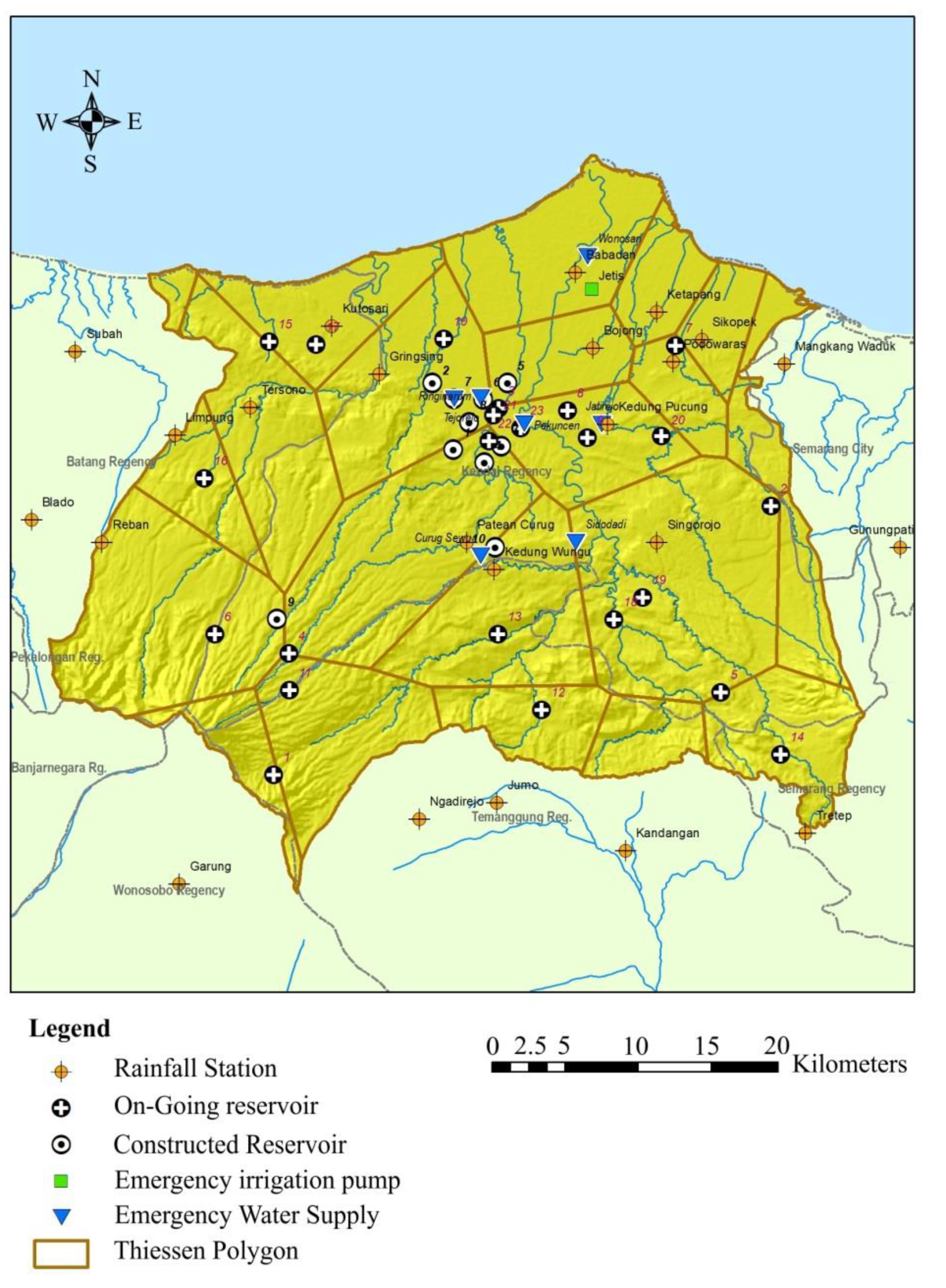
The location of the study was the Bodri-Kuto river basin in the Central Java province, which includes the regencies of Kendal, Semarang, Batang, and Temanggung, as shown in Figure 1. Figure 2 shows the locations of the constructed small reservoirs, reservoirs under construction in 2017, rainfall stations, and areas supplied with emergency water by water truck and pumped irrigation in the Bodri-Kuto river basin.

2.2. Data

We used secondary data of 17 years (2000–2016) of rainfall records from 25 stations in the catchment obtained from the Water Resources Agency in Central Java; the location of emergency water supply and irrigation data were obtained from the Kendal Disaster Management Agency; and the location of the small reservoirs that 1) have been completed (Table 1 and Table 2) are undergoing construction and are planned (Table 2) were collected from the Water Resources Agency in the Central Java province, the Agricultural Department, and the Forestry Department. Other data included information on the occurrences of drought in the field obtained from governmental offices, villages, and newspapers.

2.3. Analysis

The nature of droughts is complex, and any drought index should realistically consider climatological factors such as rainfall, temperature, air humidity, wind, and soil conditions. The selection of a drought index for analysis is dependent on the specific region, available information (data base), and the objective of the analysis [7]. Hao and Singh [8] comprehensively reviewed some drought indices, addressing the principles of the methods along with their limitations and strengths. Svoboda et al. [9] reported that no singular index can portray drought conditions for all of space and time. Droughts are multidimensional in nature, manifested on different temporal scales, and cannot be fully characterized using a single indicator [10].
The use of SPI [11] has been popular, primarily due to its less complicated formulation and requiring only rainfall time series, as well as being capable of characterizing both temporal and spatial climatological drought conditions [12].
Sayari et al. [13] applied three drought indices: SPI, precipitation index percent of normal (PIPN), and agricultural rainfall index (ARI) using databases from 1990 to 1961 in Northeast Iran. The future drought conditions in the Kashafrood basin, Iran, due to climate change resulting from low and high greenhouse gas emission scenarios (Special Report on Emission Scenarios or SRES B2 and SRES A2, respectively) were predicted using all three indices. All indices indicated higher drought frequency as a result of climate change under both scenarios. The findings support that even the simple SPI can provide equally good results compared with the more detailed indices (PIPN and ARI).
Saada and Abu-Romman [14] studied the use of contemporaneous autoregressive moving average (CARMA) time series analysis to model the SPI at a time scale of 12 months (SPI-12) in the northwest mountainous region in Jordan. They used a rainfall database recorded from five rainfall stations from 1983 to 2013 (30 years). The results demonstrated that CARMA (1,1) can model the SPI in the region and that the cross-correlation structures between the stations were well preserved.
Setiawan et al. [15] applied the normalized monthly precipitation and SPI to study the influence of El Niño events using rainfall data based on 1950–2010 in Indonesia. They found that the influence of El Niño events is better represented by use of SPI. The use of temporal and spatial SPI in more regions and seasons affected by El Niño can more accurately reflect drought outlook.
Tshiabukole et al. [6] applied SPI to analyze the influence of climatic variability to the seasonal rainfall pattern in Southwestern Congo. They found that the frequency of occurrence of dry periods in successive years is relatively low, although 25 years over the last 50 years have experienced droughts.
Recently, Theresia et al. [5] used SPI to evaluate the correlation between drought area and the location of small reservoir construction in the Bodri-Kuto river basin In Indonesia. They reported the low suitability of the locations of small reservoirs given the drought conditions. However, Theresia et al. [5] used SPI defined as the standardized deviation from its respective month [5]. This use of SPI only indicates each month’s deviation, resulting in different dry spell definitions in different months despite having equal SPI values. Secondly, they applied drought severity criteria based on simultaneous drought frequencies of dry and very dry spells in consecutive months. This joint drought severity definition means the probability of drought conditions may not reflect field conditions.
The SPI in this study was calculated both yearly and monthly. For yearly SPI, we used the mean of yearly rainfall data as the reference; for monthly SPI, we used the mean of monthly rainfall data as the reference applicable throughout the months. In principle, the index calculates the standardized rainfall. When the SPI is less than the average, the index is negative. The larger the negative value, the larger the deviation (smaller than) from its average or reference value, indicating a more severe drought index. The SPI formula is as follows [5,16,17]:
SPI = X i X ¯ σ
where X i is rainfall (mm) at time period I, X ¯ is average rainfall (mm), and σ is the standard deviation (mm).
Based on the SPI calculated above, the drought condition was classified as shown in Table 3.
The analysis performed in this study was as follows:
(1) SPI calculation: The SPI was analyzed for 17 years of rainfall records (2000–2016) from 25 rainfall stations in the river basin. Before the SPI analysis, the missing data were filled with inversed square distance values [18] and the data were checked for consistency using the double mass curve with correction [19].
(2) The dry months were also crosschecked using Oldeman’s method [20]. We confirmed that July to September are the driest months.
(3) Spatial interpolation was performed based on the SPI at 25 rainfall stations. The spatial interpolation throughout the river basin was performed using multi-dimension inverse distance weighting (IDW) in ArcMap by Environmental Systems Research Institute (ESRI) [21] to obtain the spatial distribution of SPI [22]. Other approaches to define spatial distribution include using principle component analysis for clustering homogenous regions based on SPI [23].
(4) Drought classification and mapping: Based on the spatial SPI, drought conditions were spatially classified based on Tshiabukole et al. [4], as shown in Table 3.
(5) Severity of drought: The severity of drought is based on monthly SPI. The longer the dry condition (as indicated by SPI), the more severe the drought. Severe drought conditions are experienced when the location is continuously dry condition for three months. The criteria for drought severity are shown in Table 4.
(6) Location suitability: The suitability of reservoir locations based on the SPI was obtained from overlying the spatial mapping of the drought classification with the locations of the small reservoirs (constructed or planned).

3. Results

3.1. Yearly SPI

The yearly SPI was used to identify the driest years, which was achieved by counting the number of rainfall stations whose records showed dry conditions. Figure 3 shows the number of rainfall stations (out of 25) that experienced moderately dry or worse conditions (SPI < −0.50) every year. In 2000, for example, four stations experienced moderately dry conditions, three experienced dry conditions, and two experienced very dry conditions. In total, nine stations (out of 25) experienced moderately dry or worse conditions in 2000. Figure 3 shows that the driest years were observed in 2005, 2006, 2007, 2009, 2012, and 2015, where more than 10 rainfall stations simultaneously experienced moderately dry or worse conditions (SPI < −0.50).
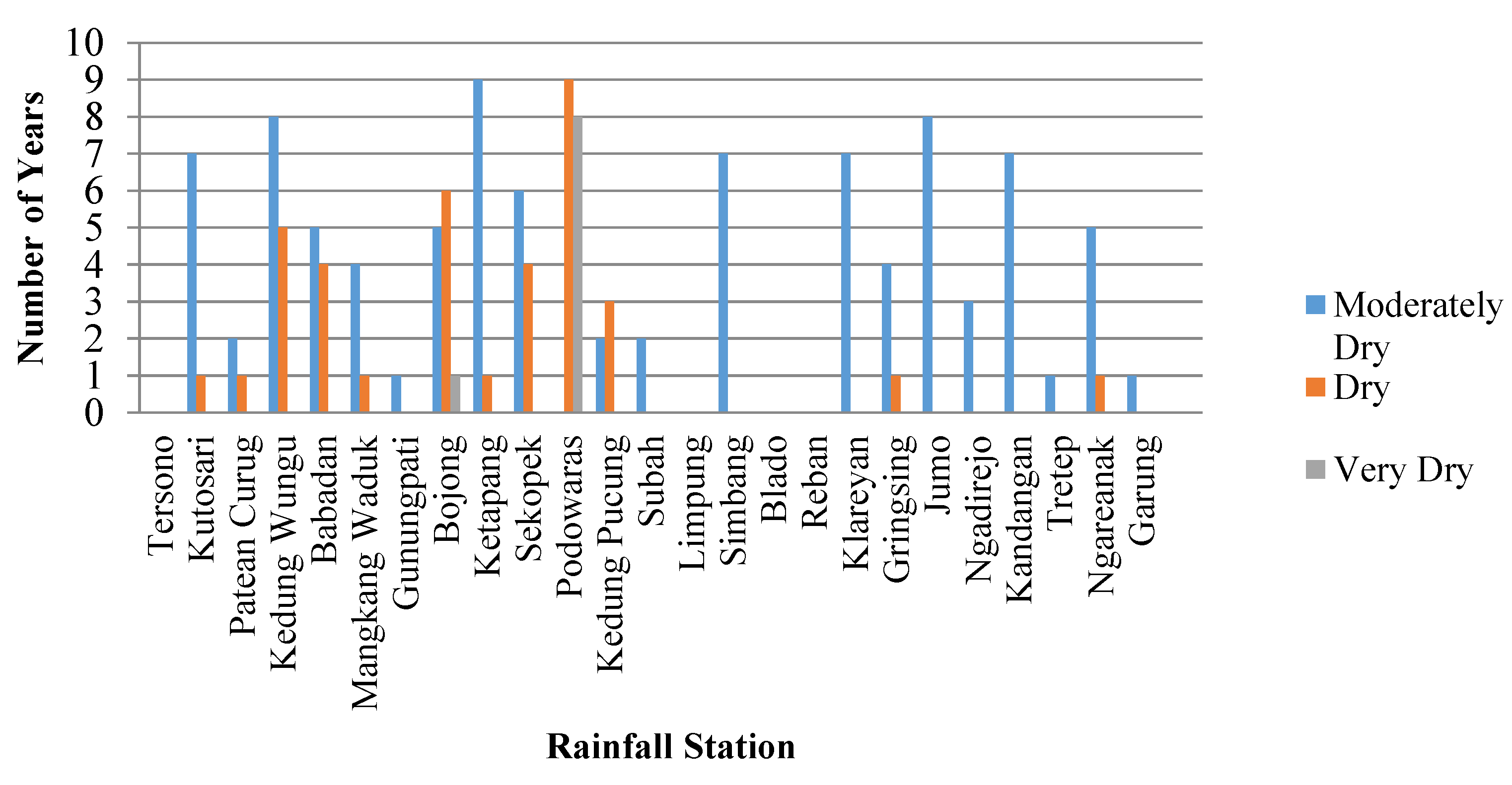
Figure 4 shows the frequency of moderately dry or worse conditions at the various stations. The worst rainfall record was observed at Podowaras station, which experienced nine years of dry conditions and eight years of very dry conditions out of the 17 years of records (2000–2016). Other rainfall records showing moderately dry or worse conditions included Kedung Wungu (13 years), Babadan (9 years), Bojong (12 years), Ketapang (10 years), and Sekopek (10 years).

3.2. Monthly SPI

The result of monthly SPI for all 25 rainfall stations is shown in Table 5. On average, the moderately dry months were June to October, with SPI values below −0.5 (moderately dry or worse). In this analysis, we used the driest three months: July, August, and September.
Figure 5 shows the driest rainfall stations based on monthly SPI. The driest month was August followed by July and September, which showed moderately dry and dry conditions. The rainfall records showing the driest conditions were those from the Kedung Wungu, Ketapang, Sekopek, Podowaras, Simbang, Klareyan, and Singorojo stations based on both monthly and yearly SPI.
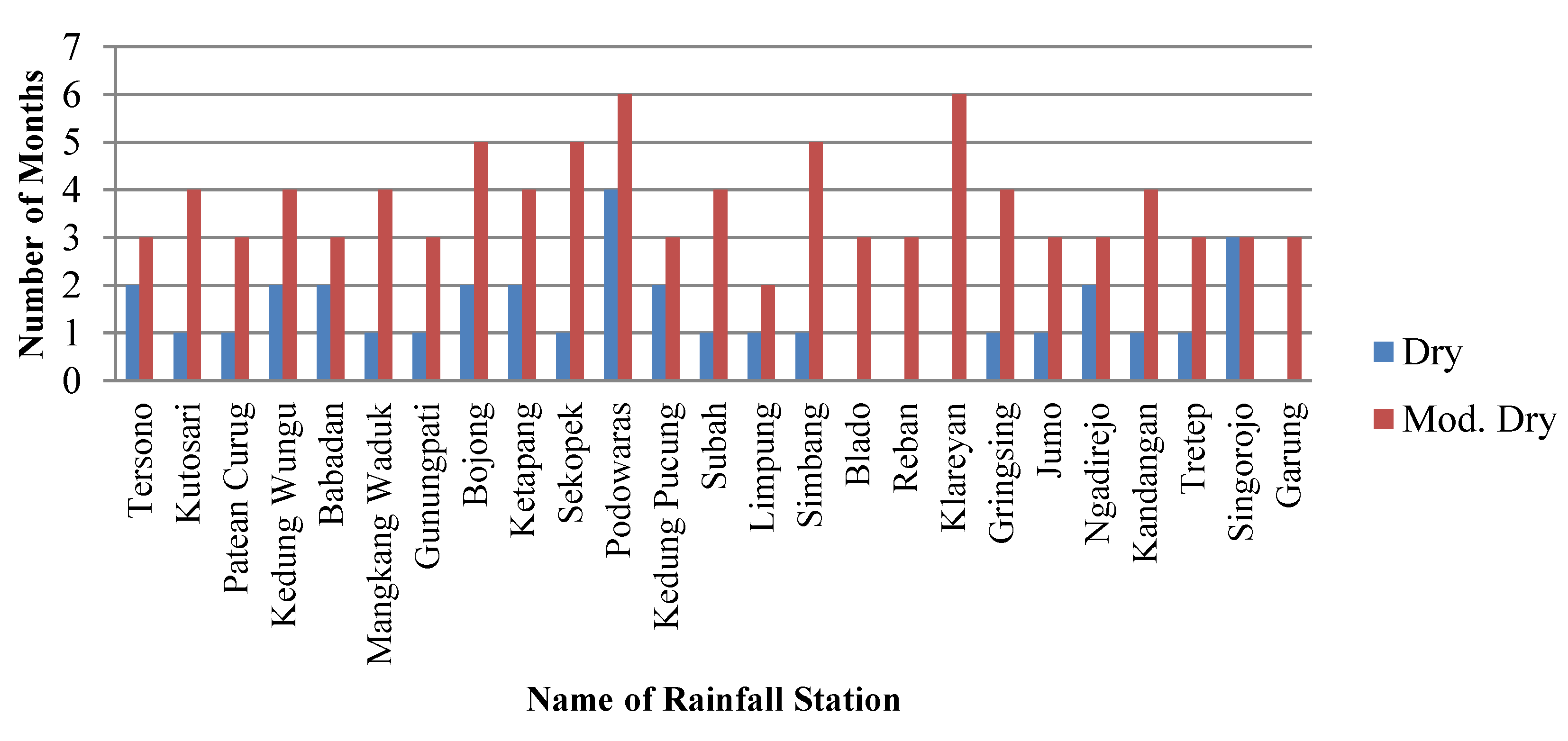
Figure 6 shows the number of rainfall stations that were experiencing moderately dry or worse conditions. During the driest months of July, August, and September, all rainfall records indicated moderately dry or worse conditions. Figure 7 shows the number of months in the year where the rainfall records showed moderately dry or worse conditions. Figure 8 shows the monthly SPI during the driest months of July, August, and September.

4. Discussion

4.1. Spatial Distribution of Drought

The spatial distribution of monthly drought in the Bodri-Kuto river basin during July, August, and September is shown in Figure 9, where yellow indicates moderately dry areas and the dark yellow indicates dry conditions. In July, 19 stations were moderately dry and six stations were dry. The six stations reporting dry conditions in July were Babadan, Bojong, Ketapang, Podowaras, Ngadirejo, and Singorojo, which are mostly located in the center of the river basin (dark yellow area). In August, only four stations reported moderately dry conditions (Blado, Reban, Klareyan, and Garung), which are located at the northeast part of the river basin (yellow area). In September, five stations (Tersono, Kedungungu, Podowaras, Kedung Pucung, and Singorojo) experienced dry conditions (dark yellow).
The severity of drought was determined on the basis of the criteria in Table 2 and is shown in Figure 10. The Podowaras and Singorojo stations experienced continuous dry conditions in July, August, and September. The areas shown in Figure 10 in dark brown are most suitable for the construction of small reservoirs. The areas indicated in brown are suitable, whereas the areas indicated in light brown are moderately suitable. The drought severity map in Figure 10 is overlaid with the locations of the small reservoirs (constructed and under construction) and locations of emergency water supplies (water truck and pumped irrigation). The figure shows that the emergency water supply in Curug Sewu, Sidodadi, Jatirejo, Pekuncen, and Wonosari aligns with the drought-affected areas.

4.2. Location Suitability of Constructed Reservoirs

The locations of some constructed reservoirs overlaid with the drought severity map are shown in Figure 10 and the location suitability is listed in Table 6. Only one reservoir (No. 10, Sidokumpul) is located in a suitable area (i.e., with high severity drought). The Sidokumpul small reservoir was constructed in 2013 and uses springs as its sources of water. It is located at the sub-regency Patean, which experiences drought and water shortage every year and is thus dependent on water tank supply (see Figure 2). The result aligns with the field conditions where the Sidokumpul small reservoir is used for supplying domestic water needs, cattle, and irrigation. The Sidokumpul reservoir is also used to supply water to the Sojomerto Weir, thus extending its services to the irrigation area. This finding agrees with the field conditions and is in concordance with that previously reported [3].
The other nine reservoirs (90%) are located in moderately dry areas, which are thus in moderately suitable locations. In the field, there are six reservoirs located in dry areas that required water truck supply. They are Sidokumpul, Triharjo, Sojomerto, Harjodowo, Ringinarum, and Tejorejo. Compared with a previous study [3], only 80% of small reservoirs were constructed in less suitable locations.

4.3. Location Suitability of Reservoirs Under Construction

The locations of reservoirs under construction overlaid on the drought severity map are shown in Figure 10 and their suitability is listed in Table 7. Of the 23 reservoirs under construction, one reservoir (4%) is in a very suitable location (Karangtengah, No. 7), six reservoirs (26%) are in suitable locations, 15 reservoirs (65%) are in a moderately suitable location, and only one reservoir (Blumah) is located in a less suitable location. In total there are 22 (=95.65%) reservoirs located in areas of moderately suitable to very suitable locations. Another study [3] showed that 57% of the small reservoirs under construction were in less suitable locations.
Overall, Table 8 shows that out of a total of 33 reservoir locations, one (3%) is very suitable, seven (21%) are suitable, 24 (73%) are moderately suitable, and only one (3%) location is less suitable.

5. Conclusions

For the locations of existing small reservoirs, one (10%) is suitable and nine (90%) are moderately suitable. For small reservoirs under construction, one (4%) is very suitable, six (26%) are suitable, 15 (65%) are moderately suitable, and one (4%) is less suitable. This is an improvement in the suitability percentage compared to the findings reported previously [3].
Overall, of 33 reservoirs under construction in the Bodri-Kuto river basin, eight (24%) are either very suitable or suitable. The locations of the other 24 small reservoirs (73%) are only moderately suitable as they are located in drought-prone areas. We also found that the suitability of the under-construction and planned small reservoirs is increasing.
The small reservoirs constructed in available land locations instead of technically ideal locations are still located within suitable dry or moderately dry areas.
To improve the effectiveness of reservoir construction, the drought severity in the areas surrounding the reservoir should be considered in addition to the technically sound criteria.
The use of spatial and temporal SPI can help determine suitable locations for small reservoirs. However, the quality of the results is also influenced by the spatial distribution of the rainfall stations. The higher the density of rainfall stations, the better the spatial SPI distribution.

Author Contributions

Conceptualization and methodology: S.S. and T.N.S.H.; software: T.N.S.H. and I.S.; validation, formal analysis, investigation, resources: S.S., I.S., T.N.S.H. and F.S.; data T.N.S.H.; writing—original draft preparation: S.S. and I.S.; writing—review and editing: S.S., I.S., and F.S.; visualization: I.S., T.N.S.H. and F.S. All authors have read and agree to the published version of the manuscript.

Funding

This research received no external funding.

Acknowledgments

The authors express their sincere thanks to the office of Water Resources Agency Central Java Province, Central Java Agricultural Department, and Kendal Disaster Management Board for providing data used in the analysis.

Conflicts of Interest

The authors declare no conflict of interest.

References

  1. Abbas, M.N.; Biswajeet, P.; Qayssar, M.A. Dam site suitability assessment at the Greater Zab River in northern Iraq using remote sensing data and GIS. J. Hydrol. 2019, 574, 964–979. [Google Scholar] [CrossRef]
  2. Al-Ruzouq, R.; Abdallah, S.; Abdullah, G.Y.; AlaEldin, I.; Sunanda, M.; Mohamad, A.K.; Mohamed, B.A.G. Dam Site Suitability Mapping and Analysis Using an Integrated GIS and Machine Learning Approach. Water 2019, 11, 1880. [Google Scholar] [CrossRef] [Green Version]
  3. PWC. The 2nd Edition of PwC’s Annual Indonesian Infrastructure Report. 2016. Available online: www.pwc.com/id (accessed on 10 September 2019).
  4. Babatunde, S.O.; Adeniyi, O.; Awodele, O.A. Investigation into the causes of delay in land acquisition for PPP projects in developing countries. J. Eng. Des. Technol. 2017, 15, 552–570. [Google Scholar] [CrossRef]
  5. Harjanti, T.N.S. Suitability Analysis of Reservoir’s Location using GIS Based SPI Index (Case Study: Bodri Kuto River basin). In Proceedings of the 5th International Conference on Sustainable Built Environment (ICSBE), Banjarmasin, Indonesia, 11–13 October 2018; Volume 280. [Google Scholar] [CrossRef]
  6. Tshiabukole, K.; Khonde, P.; Muku, M.; Vumilia, K.; Lunekua, K.; Kankolongo, M. Influence of Climate Variability on Seasonal Rainfall Patterns in South-Western DR Congo. Open Access Libr. J. 2016, 3, e2952. [Google Scholar] [CrossRef]
  7. Smakhtin, V.U.; Schipper, E.L.F. Droughts: The impact of semantics and perceptions. Water Policy 2008, 10, 131–143. [Google Scholar] [CrossRef]
  8. Hao, Z.; Singh, V.P. Drought characterization from a multivariate perspective: A review. J. Hydrol. 2015, 527, 668–678. [Google Scholar] [CrossRef]
  9. Svoboda, M.D.; Fuchs, B.A.; Poulsen, C.C.; Nothwehr, J.R. The drought risk atlas: Enhancing decision support for drought risk management in the United States. J. Hydrol. 2015, 526, 274–286. [Google Scholar] [CrossRef] [Green Version]
  10. Temam, D.; Uddameri, V.; Mohammadi, G.; Hernandez, E.A.; Ekwaro-Osire, S. Long-Term Drought Trends in Ethiopia with Implications for Dryland Agriculture. Water 2019, 11, 2571. [Google Scholar] [CrossRef] [Green Version]
  11. Spinoni, J.; Naumann, G.; Carrao, H.; Barbosa, P.; Vogt, J. World drought frequency, duration, and severity for 1951–2010. Int. J. Climatol. 2013, 34, 2792–2804. [Google Scholar] [CrossRef] [Green Version]
  12. Hou, Y.Y.; He, Y.B.; Liu, Q.H.; Tian, G.L. Research progress on drought indices. China J. Ecol. 2007, 26, 892–897. [Google Scholar]
  13. Sayari, N.; Bannayan, M.; Alizadeh, A.; Farid, A. Using drought indices to assess climate change impacts on drought conditions in the northeast of Iran (case study: Kashafrood basin). Meteorol. Appl. 2013, 20, 115–127. [Google Scholar] [CrossRef]
  14. Saada, N.; Abu-Romman, A. Multi-site Modeling and Simulation of the Standardized Precipitation Index (SPI) in Jordan. J. Hydrol. Reg. Stud. 2017, 14, 83–91. [Google Scholar] [CrossRef]
  15. Setiawan, A.M.; Lee, W.S.; Rhee, J. Spatio-temporal characteristics of Indonesian drought related to El Niño events and its predictability using the multi-model ensemble. Int. J. Climatol. 2017, 37, 4700–4719. [Google Scholar] [CrossRef]
  16. Utami, D. Prediksi Kekeringan Berdasarkan Standardized Precipitation Index (SPI) Pada Daerah Aliran Sungai Keduang Di Kabupaten Wonogiri. Matriks Tek. Sipil 2013, 1, 84. [Google Scholar]
  17. Mamad, T. Mengestimasi Tingkat Kekeringan Menggunakan SPI (Standardized Precipitation Index). Institut Teknologi Bandung. Available online: https://mamadtama.wordpress.com/2014/04/19/mengestimasi-tingkat-kekeringan-menggunakan-spi-standardized-precipitation-index/ (accessed on 19 September 2017).
  18. Fisher, N.I.; Lewis, T.; Embleton, B.J.J. Statistical Analysis of Spherical Data; Cambridge University Press: Cambridge, UK, 1987; p. 329. [Google Scholar]
  19. Wilson, E.M. Engineering Hydrology, 3rd ed.; Macmillan Press: London, UK, 1983; p. 27. [Google Scholar]
  20. Parvin, I.; Saleh, A.F.M. Assessment of Agricultural Drought in 2006 Aman Season and Its Management by the Farmers: A Case Study in Rajshahi District Bangladesh. J. Indian Water Resour. Soc. 2013, 33, 1. [Google Scholar]
  21. ESRI. Understanding interpolation analysis. 2012. Available online: http://resources.arcgis.com/en/help/main/10.1/index.html#//003100000008000000 (accessed on 11 July 2019).
  22. Cavus, Y.; Aksoy, H. Spatial Drought Characterization for Seyhan River Basin in the Mediterranean Region of Turkey. Water 2019, 11, 1331. [Google Scholar] [CrossRef] [Green Version]
  23. Espinosa, L.A.; Portela, M.M.; Pontes Filho, J.D.; Studart, T.M.D.C.; Santos, J.F.; Rodrigues, R. Jointly Modeling Drought Characteristics with Smoothed Regionalized SPI Series for a Small Island. Water 2019, 11, 2489. [Google Scholar] [CrossRef] [Green Version]
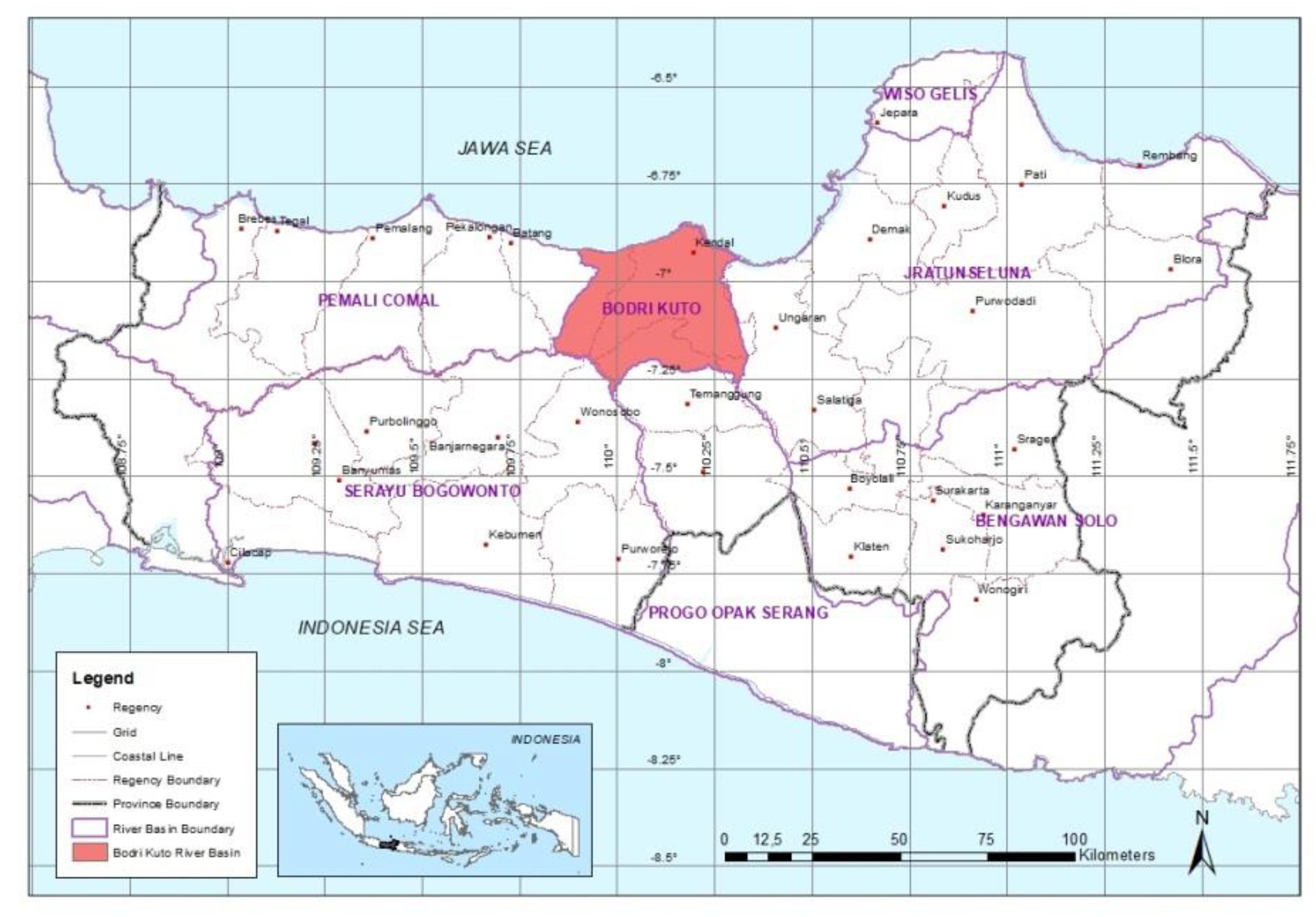
Figure 1. Location of the study area in the Central Java province.
Water 12 00993 g001
Figure 2. Locations of small reservoirs in the Bodri-Kuto river basin.
Water 12 00993 g002
Figure 3. Number of rainfall stations experiencing moderately dry or worse conditions.
Water 12 00993 g003
Figure 4. Rainfall stations experiencing moderately dry or worse conditions.
Water 12 00993 g004
Figure 5. Monthly SPI at the driest rainfall stations.
Water 12 00993 g005
Figure 6. Number of rainfall stations experiencing moderately dry or worse conditions.
Water 12 00993 g006
Figure 7. Frequency of rainfall stations experiencing moderately dry or worse conditions in the Bodri-Kuto river basin.
Water 12 00993 g007
Figure 8. Monthly SPI of the driest months of July, August, and September in the Bodri-Kuto river basin.
Water 12 00993 g008
Figure 9. Spatial monthly SPI distribution in the Bodri-Kuto river basin.
Water 12 00993 g009
Figure 10. Overlay of small reservoir locations and drought severity map.
Water 12 00993 g010
Table 1. Constructed small reservoirs in the river basin.
No.Small ReservoirSource of WaterCapacity
(× 106 m3)
Constr.Dry Area
1KedungasriRain-fed0.022016-
2BumiayuIrrig. and Rain-fed0.0252013-
3TriharjoIrrig. and Rain-fed0.022012yes
4SojomertoIrrig. and Rain-fed0.0252016yes
5RowobratenRain-fed0.022017-
6RinginarumRain-fed0.032017-
7TejorejoRain-fed0.052017-
8NgerjoRain-fed0.022016-
9HarjodowoRain-fed0.022016yes
10SidokumpulSpring0.022013yes
Table 2. On-going small reservoir developments (under construction or planned).
No.Small ReservoirSource of WaterCapacity
(× 106 m3)
Constr.Dry Area
1WonoboyoSpring0.1-yes
2TrisoboIrrig. and Rain-fed0.04--
3KedunggadingRain-fed0.04--
4TamanrejoRain-fed0.02-yes
5KedungbotoRain-fed0.08-yes
6BlumahRain-fed0.02-yes
7KarangtengahRain-fed0.02-yes
8WonosariRain-fed0.02-yes
9JatirejoRain-fed0.02-yes
10WonotenggangRain-fed0.02--
11NglaranganRain-fed0.1-yes
12GemawangRain-fed0.08-yes
13BejenRain-fed0.07-yes
14SumowonoRain-fed0.05--
15SawanganRain-fed0.1-yes
16NgaliyanRain-fed0.1-yes
17GringsingRain-fed0.08-yes
18W. CeningKali Putih River10.00--
19W. Bodri (Banyuwaringin)Kali Putih River42.00--
20W. KedungsurenBlorong River24.48-yes
21Kedunggading 2Rain-fed0.02--
22Sojomerto 2Irrig. and Rain-fed0.02-yes
23Triharjo 2Irrig. and Rain-fed0.02-yes
Table 3. Drought classification based on SPI values [6].
Value of SPIDrought Condition
−0.49 to 0.49Normal
−0.50 to −0.99Moderately dry
−1.00 to −1.49Dry
−1.50 to −1.99Very dry
<−2.00Extreme dry
Table 4. Drought duration, severity, and location suitability.
No.Duration *Drought SeveritySuitability
13 monthsVery HighVery Suitable
22 monthsHighSuitable
31 monthsModerateModerately Suitable
4-LowLess Suitable
* Monthly SPI < −0.50 (moderately dry or worse).
Table 5. Monthly SPI at 25 rainfall stations.
No.Rainfall StationMonthly SPI
JanuaryFebruaryMarchAprilMayJuneJulyAugustSeptemberOctoberNovemberDecember
1Tersono1.822.870.830.70−0.22−0.55−0.76−1.06−1.00−0.570.191.41
2Kutosari1.181.30−0.32−0.33−0.45−0.71−0.91−1.10−0.96−0.80−0.030.27
3Patean Curug1.081.050.810.40−0.12−0.58−0.79−1.06−0.94−0.400.430.72
4Kedung Wungu0.810.75−0.18−0.24−0.46−0.72−0.88−1.20−1.10−0.90−0.54−0.05
5Babadan0.761.06−0.14−0.44−0.42−0.77−1.01−1.16−0.96−0.75−0.360.11
6Mangkang Waduk1.341.300.230.14−0.21−0.55−0.75−1.12−0.89−0.60−0.010.32
7Gunungpati1.661.041.000.55−0.20−0.69−0.97−1.10−0.81−0.430.740.88
8Bojong0.700.50−0.29−0.30−0.59−0.80−1.01−1.16−0.95−0.83−0.510.11
9Ketapang1.101.13−0.22−0.40−0.62−0.68−1.03−1.15−0.93−0.60−0.250.14
10Sekopek0.870.86−0.17−0.27−0.53−0.71−0.96−1.13−0.97−0.71−0.390.12
11Podowaras−0.34−0.17−0.71−0.70−0.93−0.93−1.10−1.20−1.10−1.03−0.81−0.56
12Kedung Pucung1.150.870.350.38−0.25−0.57−0.73−1.14−1.06−0.730.040.33
13Subah2.032.480.18−0.12−0.49−0.64−0.70−1.08−0.91−0.62−0.080.28
14Limpung2.092.250.730.57−0.19−0.41−0.76−1.01−0.90−0.430.290.87
15Simbang1.592.09−0.09−0.28−0.60−0.74−0.81−1.04−0.98−0.77−0.39−0.06
16Blado3.523.372.231.550.880.07−0.53−0.84−0.760.251.262.05
17Reban3.734.202.392.081.02−0.07−0.60−0.58−0.530.011.142.59
18Klareyan1.571.120.40−0.20−0.68−0.56−0.78−0.97−0.71−0.91−0.430.48
19Gringsing1.331.87−0.14−0.27−0.43−0.65−0.85−1.09−0.97−0.72−0.090.37
20Jumo0.410.530.760.28−0.37−0.91−0.90−1.11−0.91−0.440.140.39
21Ngadirejo0.800.660.720.39−0.38−0.82−1.03−1.09−0.88−0.620.110.78
22Kandangan0.740.160.420.15−0.53−0.97−0.87−1.03−0.87−0.310.370.64
23Tretep1.471.201.090.990.04−0.60−0.83−1.06−0.73−0.240.701.52
24Singorojo0.980.570.320.17−0.50−0.81−1.03−1.18−1.01−0.530.060.77
25Garung1.751.471.901.350.36−0.50−0.77−0.89−0.620.391.451.92
Max3.734.202.392.081.020.07−0.53−0.58−0.530.391.452.59
Min−0.34−0.17−0.71−0.70−0.93−0.97−1.10−1.20−1.10−1.03−0.81−0.56
Average1.371.380.480.25−0.27−0.63−0.85−1.06−0.90−0.530.120.66
Table 6. Location suitability of the constructed small reservoirs.
No.NameDrought SeveritySuitability
1KedungasriModerateModerate
2BumiayuModerateModerate
3TriharjoModerateModerate
4SojomertoModerateModerate
5RowobrantenModerateModerate
6RinginarumModerateModerate
7TejorejoModerateModerate
8NgerjoModerateModerate
9HarjodowoModerateModerate
10SidokumpulHighSuitable
Total:
Very Suitable0 (0%)
Suitable1 (10%)
Moderately Suitable9 (90%)
Less Suitable0 (0%)
Table 7. Location suitability of the small reservoirs under construction.
No.NameDrought SeveritySuitability
1WonoboyoModerateModerate
2TrisoboModerateModerate
3KedunggadingModerateModerate
4TamanrejoModerateModerate
5KedungbotoModerateModerate
6BlumahLowLess
7KarangtengahVery HighVery
8WonosariHighSuitable
9JatirejoHighSuitable
10WonotenggangModerateModerate
11NglaranganModerateModerate
12GemawangModerateModerate
13BejenHighSuitable
14SumowonoModerateModerate
15SawanganModerateModerate
16NgaliyanModerateModerate
17GringsingModerateModerate
18W. CeningModerateModerate
19W. BanyuwaringinHighSuitable
20W. KedungsurenHighSuitable
21Kdg Gading2ModerateModerate
22Sojomerto2ModerateModerate
23Triharjo2HighSuitable
Total:
Very Suitable1 (4%)
Suitable6 (26%)
Moderately Suitable15 (65%)
Less Suitable1 (4%)
Table 8. Overall location suitability.
No.SuitabilityConstructedUnder ConstructionTotal
1Very Suitable0 (0%)1 (4%)13%
2Suitable1 (10%)6 (26%)721%
3Moderately Suitable9 (90%)15 (65%)2473%
4Less Suitable0 (0%)1 (4%)13%
Total10 (100%)23 (100%)33100%