Article

HEM Impoundment—A Numerical Prediction Tool for the Water Framework Directive Assessment of Impounded River Reaches

1
Christian Doppler Laboratory for Sediment Research and Management, Institute of Hydraulic Engineering and River Research, Department of Water-Atmosphere-Environment, University of Natural Resources and Life Sciences Vienna, Muthgasse 107, 1190 Vienna, Austria
2
Institute of Hydraulic Engineering and River Research, Department of Water-Atmosphere-Environment, University of Natural Resources and Life Sciences Vienna, Muthgasse 107, 1190 Vienna, Austria
*
Author to whom correspondence should be addressed.
Water 2020, 12(4), 1045; https://doi.org/10.3390/w12041045
Submission received: 16 March 2020 / Revised: 3 April 2020 / Accepted: 5 April 2020 / Published: 7 April 2020
(This article belongs to the Special Issue Sediment Management: Hydropower Improvement and Habitat Evaluation)

Abstract

:
A novel prediction tool is presented as a component of the Habitat Evaluation Model (HEM), which allows the assessment of the ecological status of impounded water bodies based on environmental factors that were shown in literature to correlate with the abundance of benthic macro-invertebrates. Main model parameters are the observed grain sizes and depth-averaged flow velocities obtained from a hydrodynamic simulation. The tool was tested in three Austrian river reaches. It was found that the river lengths predicted to be ecologically affected by the impoundments were substantially shorter for mean flow conditions than previously assessed when employing a physical mapping approach. The differences disappeared for low discharge conditions. The numerical prediction tool allows us to perform a status assessment for discharge conditions, which are potentially more representative of the annual discharge spectrum than those within the in-situ observable range. This property, thus, bears the potential to facilitate the recommendation of sediment management strategies in impounded river reaches in the future.

1. Introduction

The abundance and biomass of aquatic biota, such as fish and benthic macro-invertebrates, reflects the hydro-morphological status of a water body [1]. Therefore, the EU Water Framework Directive (Directive 2000/60/EC) defines them as key quality elements. Moreover, water quality and quantity of flow as well as bed sediments, such as the actual sediment composition, are both key elements and limiters of the abundance of benthic macro-invertebrates [2]. Lack of gravel and gravel dynamics are known to yield negative consequences for aquatic biota [3]. This is particularly the case in impounded river reaches, where fine sediment in suspension settles due to low flow velocities.
Various processes have been identified to play a role in habitat degradation of benthic macro-invertebrates related to fine sediment. On the one hand, the clogging of pore space based on very fine material, mainly clay substrate, has been frequently documented [4] and defined as siltation to describe the degradation of macro-invertebrate habitats [5]. Infiltration of fine sediment with sizes smaller than 2 mm was identified as one of the main drivers for physical habitat degradation [6]. On the other hand, an overall sediment deficit in free-flowing sections was shown to result in a depauperate macro-invertebrate fauna [3]. Moreover, several studies investigated the effect of reservoir flushing on the macro-invertebrate communities downstream and found a significant decrease of biomass due to fine sediment deposition or benthic abrasion [7,8,9]. The recovery duration of benthic organisms after such an event was found to range from several weeks [10] to several months [9]. The results of Kaller and Hartman [11] indicate that exceedance of a threshold level of fine sediment deposition may be responsible for a negative effect on benthic macro-invertebrate communities.
Habitat modelling was established as a predictive tool since the 1980s [12] with a focus on the habitat assessment for fish [13]. Early work toward constructing habitat suitability models for benthic macro-invertebrates was conducted by Jowett et al. [14] and Gore et al. [15]. Since then, several studies were undertaken in habitat modelling of macro-invertebrates, mostly as an indicator of water quality [16,17,18,19]. Some studies particularly used macro-invertebrates as indicators to assess the ecological conditions of river reaches [20]. Different parameters were employed in various model approaches, ranging from landscape attributes, such as stream gradient, forest cover, and water quality [21] or general land use types [22] to local stream parameters, i.e., flow velocity, water depth, and substrate [2]. The latter are also typically used in habitat models for fish on a micro-scale and meso-scale [23,24]. In the research from Hauer et al. [25], the importance of hydro-morphological variance, which is closely related to the substrate composition, was highlighted. The question of whether it is necessary to employ season-specific criteria when modelling habitats of benthic invertebrates could be answered by Theodoropoulos [26] in favor of general criteria. While many of the habitat models rely on field mapping approaches to obtain the necessary abiotic parameters, others use 2D depth-averaged hydrodynamic models [27,28,29,30,31] for that purpose.
The first systematic field study to investigate benthic macro-invertebrate habitat suitability in impoundments was conducted by Ofenböck et al. [32]. They studied five different impounded reaches and analyzed previously published data to arrive at the conclusion that the ecological status can be inferred based on the Water Framework Directive-standardized sampling according to the standard procedure defined by the Austrian Quality Target Ordinance for the Ecology of Surface Water Bodies [33]. This status (reflecting an aggregated form of suitability) can be assessed with regard to benthic macro-invertebrates based on characteristic grain sizes of bed sediments, which imposes a limiting value, and flow velocities. As an alternative to the flow velocity classes published in Reference [32], the flow velocities corresponding to the saprobic index classifier introduced by Zelinka and Marvan [34] present an evaluation scheme that was historically used.
The central aim of the presented study was to develop and test a numerical prediction tool, which allows a reach-based assessment of the ecological status of impounded sections. The innovation is reflected in the linkage on this aggregated scale (in extension to micro-habitat suitability [35,36]) to hydrodynamic variables for testing various impounded sites. The status is approximated from mean grain sizes of the bed substrate and depth-averaged flow velocities, which originate from 2D hydrodynamic simulations. The novel prediction tool was applied to three different study sites with similarities in the sediment regime and high aggradation rates in impounded sections for testing purposes. For each of them, field measurements and hydrodynamic simulations were performed. Based on these data, the ecologically-affected impoundment length was determined.

2. Materials and Methods

2.1. Study Sites

Three river sections were selected in which (i) a run-of-river power plant is located with an installed capacity less than or equal to 10 MW, with (ii) a significant bedload accumulation in the impounded area. The rivers are part of the Danube River basin and have a catchment area size between 181.9 km² and 604.0 km², with discharges ranging from 1.58 m³ s−1 (low flow) to 215.00 m³ s−1 (flood with a return period of one year) (Figure 1, Table 1). The case studies differ in the water body type, according to the Water Framework Directive (2000/60/EC) with the categories heavily modified water body (HMWB, C.1) and the natural water body type (C.2, C.3). The ecological status is classified as moderate (C.1, C.2) and respectively good (C.3) (Table 1). The biological quality element regarding the nutrient load is classified as high (C.2) and good (C.1, C.3), which meets the objectives of the Water Framework Directive (2000/60/EC). However, all three study sites are draining the northern lime stone Alps with similarities in the bed load regime, which is indicated by moderate to high transport rates of gravel. Moreover, continuous aggradation rates are documented in all investigated impounded sections.
The geometries required for the hydrodynamic models were created by airborne laser scanning for the floodplains and additional bathymetric surveying of the river channel based on a cross-sectional approach. The processed laser scan data were provided by the respective federal states and correspond to the latest available digital terrain model with a grid resolution of 1 × 1 m. The terrestrial survey of the river bathymetry was carried out with a total station (Leica TCR 805). The official survey points of the Austrian Federal Office of Metrology and Surveying (BEV) were used for the localization within the federal coordinate system. Mean distances between the cross-sections ranged from 5–200 m. Knowledge of substrate conditions is of particular importance for assessing the habitats. Therefore, at regular distances (10–20 m), volumetric samples (according to the standard USGS (United States Geological Survey) method [37]) of the surface layer (SL) and subsurface layer (SSL) were taken, dried, and sieved. The washout of fine sediment during sampling was prevented by a 60 × 60 cm frame fixed to the riverbed. The sediment samples were taken manually by lifting off the surface layer, which was followed by volumetric sampling of the subsurface layer using a small shovel. In addition, qualitative clogging was estimated by an on-site kick-testing approach.

2.1.1. River Erlauf: Case Study 1 (C.1)

The investigated river reach is situated in the southern part of Lower Austria (48°09’ N 15°10’ E) with a mean daily low flow of QL = 4.43 m³ s−1, a mean flow of QM = 14.70 m³ s−1, and a discharge during a one-year flood of QH = 215.00 m³ s−1. The mean bed slope of this reach in the river Erlauf is 0.11%. The geometry of the hydrodynamic model consists of 51,520 nodes and 80,130 elements (Figure 2a). The cross sections were measured at a distance of 50–200 m. The floodplain geometry is based on airborne laser scanning. Sediment samples were taken along the orographic left and right banks of the river reach. A total of n = 13 surface samples and n = 13 subsurface samples were taken. The length of the impounded section, according to the National Water Management Plan (2015), is 502 m.

2.1.2. River Alm: Case Study 2 (C.2)

The river reach Alm of case study 2 is located in Upper Austria (47°51’ N 13°57’ E) with a mean daily low flow of QL = 2.43 m³ s−1, a mean flow of QM = 9.18 m³ s−1, and a discharge during a one-year flood of QH = 105.00 m³ s−1. The hydrodynamic model consists of 68,784 nodes and 68,893 elements (Figure 2b) based on n = 20 cross-sections with a distance of 5–20 m and airborne laser scanning for the floodplain. The mean bed slope is 0.11%. Sediment samples (n = 5 surface samples, n = 5 subsurface samples) were taken along the thalweg of the river reach. The length of the impounded section, according to the National Water Management Plan (2015), is 300 m.

2.1.3. River Schwarza: Case Study 3 (C.3)

The investigated river reach (47°43’ N 15°48’ E) is situated in the south-eastern part of Lower Austria with a mean daily low flow of QL = 1.58 m³ s−1, a mean flow of QM = 5.19 m³ s−1, and a discharge during a one-year flood of QH = 65.20 m³ s−1. The mean bed slope of the river reach at the river Schwarza is 0.06%. The hydrodynamic model consists of 26,868 nodes and 27,129 elements (Figure 2c) based on n = 19 cross-sections with a distance of 7–30 m. The floodplain geometry was created from airborne laser scanning data. Sediment samples (n = 7 surface samples, n = 7 subsurface samples) were taken along the thalweg of the river reach. The length of the impounded section, according to the National Water Management Plan (2015), is 421 m.

2.2. Hydrodynamic Model

The numerical simulations in this study were performed using the 2D hydrodynamic model Hydro_AS-2d [30], which solves the depth-averaged Reynolds-equations on an unstructured mesh consisting of triangles and quadrilaterals, using a finite volume approach. The model is based on the concept of Manning-Strickler bed roughness coefficients. The convective fluxes are discretized using an upwind-scheme, according to Pirroneau [38], and a second order explicit Runge Kutta method is employed for the discretization of time. All simulations for this study were performed using a parabolic eddy viscosity model and a constant turbulent viscosity coefficient of 0.6. Preprocessing and postprocessing was done using the Surface-Water Modelling System (SMS). A flow diversion into the turbine intake channel was not considered. Thus, as the downstream boundary, the entire flow of the various discharge scenarios (n = 3) passed the weir.
The two-dimensional depth-averaged flow velocities are not identical to the near-bed flow velocities. The decision to choose this approach, however, is supported by two decisive features: (i) The bathymetries and also the substrate sorting in impounded sections lead to a very “simple” hydraulic characterization including very low grain roughness. Thus, low turbulence intensities and near-bottom flow fluctuations are due to the fine(r) sediment deposits. This was fundamental for setting up the study of Ofenböck et al. [32] using depth-averaged flow information obtained from flow velocity measurements. Moreover, (ii) based on this study [32], it was possible to show that a clear connection exists between ecological status and the abundance of benthic invertebrates and abiotic parameters on this aggregated and simplified description of the abiotic environment.

2.3. Habitat Evaluation Model HEM

The Habitat Evaluation Model (HEM) [39,40] comprises a graphical user interface that allows the visualization and quantification of habitat suitability both on the micro-scale and the meso-scale. The input for HEM is provided by hydrodynamic simulations originating from either 2D or 3D models. The formats of four 2D models (CCHE2D, Hydro_AS-2d, River-2D, RSim-2D) and two 3D models (RSim-3D, SSIIM) are supported. On the micro-scale (up to 1 m grid cell size), the product of composite suitability indices ranging from 0 to 1 and derived from suitability curves for the parameters’ water depth, flow velocity, and bed substrate are calculated. The concept of Weighted Useable Areas (WUA) after Bovee [12] serves as an aggregate parameter to compare different sites. On the meso-scale (up to 100 m grid cell size), the mesohabitat suitability model according to Hauer et al. [23,40] is employed. It functionally connects the parameters’ water depth, flow velocity, and bed shear stress to classify habitats on the guild-level into six different hydro-morphological units. In analogy to the WUA concept, Useable Mesohabitat Areas (UMA) can be calculated as an aggregate parameter. All of these already implemented features focus on fish and macro-invertebrate habitats in free-flowing sections. Evaluation criteria of impounded reaches and their characteristics were missing so far.

2.4. HEM Impoundment

In the presented study, the assessment of the environmental status was done using macro-invertebrates as a biological indicator. Macro-invertebrates are an important indicator group according the European Water Framework Directive. The assessment is based on a linkage between physical parameters (flow velocity and water depth) and the ‘habitat suitability’ of those sites for the benthic community. Such approaches and relations are well documented for fish [41] and macroinvertebrates [42,43,44,45]. However, in the presented study, we applied a novel concept of an aggregated form of habitat suitability. In our new modelling concept, no single benthic species or groups were addressed (e.g., Allogamus auricollis as species, or rheophilic organisms), but the ecological status of macroinvertebrates, determined according to the national Water Framework Directive–methodology [46], was addressed. This aggregated information as an indicator was used from an extensive sampling in hydropower impacted sections conducted by Ofenböck et al. [32]. The innovation is reflected in the linkage on this aggregated scale (in extension to micro-habitat suitability [35,36]) to hydrodynamic variables and in testing various impounded sites.
The novel assessment tool was added as the third main module into HEM and consequentially named HEM Impoundment. Based on the findings of Ofenböck et al. [32], it classifies, as a predictive tool, bed substrate and depth-averaged flow velocities into the five ecological status groups according to the EU Water Framework Directive: high, good, moderate, poor, and bad. For flow velocities, either an overall assessment [32] or a classification based on the saprobic index [34] can be selected by the model operator.
Bed substrate is classified according to sediment sizes, characterized by the median diameter d50, following Table 2. The classification according to Reference [32] defines a threshold value for sediment size between the gravel and sand classes. Bed material coarser than this threshold corresponds to a potentially good ecological status, while finer bed material likely leads to a bad ecological status. Although macro-invertebrates are known to be adapted to sand bed conditions, this is due to the fact that alpine gravel bed rivers show a clear decline and deviation of abundance and biomass in terms of dominating sand fractions [32]. As visible in Figure 2, the investigated study sites vary in total length and bathymetric heterogeneity. This variability determined the number of sediment samples in the various reaches.
The overall status assessment according to the EU Water Framework Directive, accepted as standard procedure by the Austrian Federal Ministry of Agriculture, Forestry, Environment, and Water Management, is focusing on flow velocities and substrate by mainly determining benthic invertebrates [32]. It is laid out in Table 3, which defines four status classes. Contrary to this, Table 4 shows the status classification, according to the saprobic index [34], which distinguishes only three classes and is related to the assessment of water quality. This classification is, in general, less rigorous than the overall physical status assessment, according to the aims of the Water Framework Directive.
The model user can decide whether to conduct an assessment according to bed substrate and/or flow velocities. For the latter parameter, the classification according to Table 3 or Table 4 can be selected. In case both bed sediments and flow velocities are employed, the resulting lower class of both parameters is returned as a final model output. As an aggregate result, the total area (m2) and percentage distribution (% of wetted area) corresponding to each status class are predicted (optional suitability).

3. Results

3.1. Bed Sediments

Statistics of all sampled sediments in C.1 exhibit a mean diameter d50 of 34.5 mm (standard deviation of SD 18.7 mm) at the surface layer and 13.3 mm (SD 6.6 mm) at the subsurface layer, respectively. For C.2, the surface layer mean d50 is 18.3 mm (SD 9.9 mm), while the subsurface layer is characterized by a mean value of 10.9 mm (SD 2.9 mm). For site C.3, the corresponding characteristic values are 18.2 mm (SD 9.6 mm) at the surface and 13.0 mm (SD 6.9 mm) at the subsurface layer, respectively.
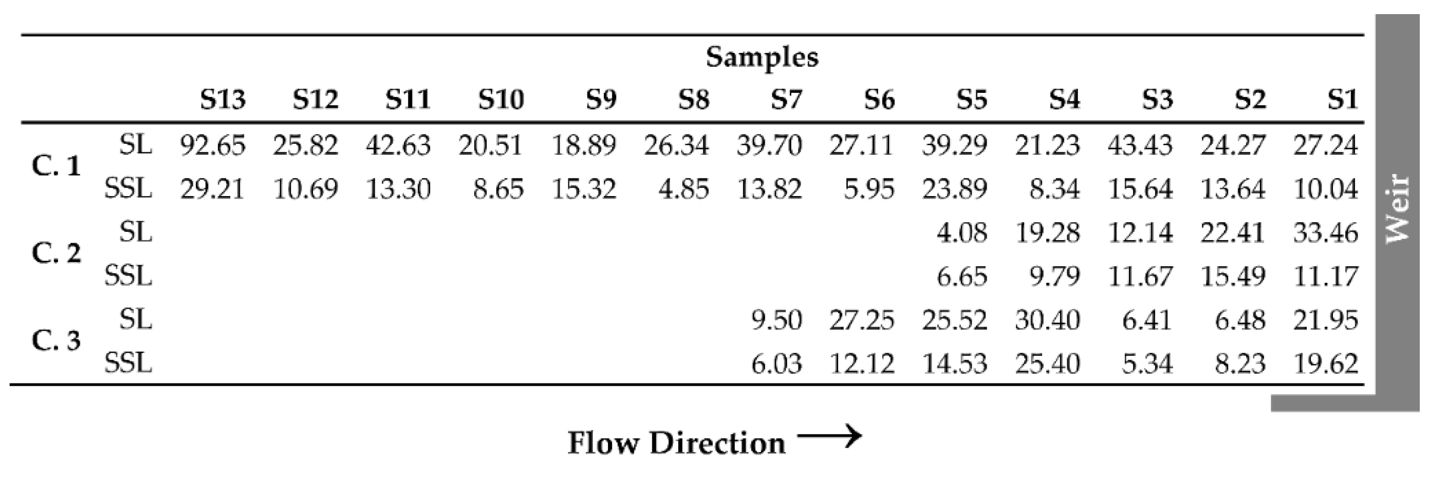
According to the study of Ofenböck et al. [32], there was a clear expectation that grain sizes are decreasing in flow direction toward the weir. The evaluation of the surface layer samples shows the expected decreasing grain sizes from upstream to downstream for the reach of case study 2. Similar results can be seen for the subsurface layer, though the grain sizes are smaller. However, the results for case study 1 and 3 are not so unambiguous. Moreover, no clear correlation between grain size and flow velocity was found (see Supplementary Materials, Figure S1). In C.1, the samples were taken along the left and right banks of the river instead of the thalweg. However, all samples (surface layer and subsurface layer, Figure 3) are greater than 2 mm, so the assessment according to the bed sediment (cf. Table 2) yields a potentially good ecological status for all reaches. Nevertheless, fine sediment concentrations (<2 mm) were determined for each of the samples (Figure 4), as increased fine sediment concentrations are indicators for clogging and habitat degradation in general. Both the qualitative kick-testing approach at sampling sites and the comparison between the surface and subsurface layer (Figure 3 and Figure 4) indicated no stabilized clogging of the bottom substrate even when the fine sediment content (<2 mm) reached elevated values at some sample points.

3.2. Hydrodynamics

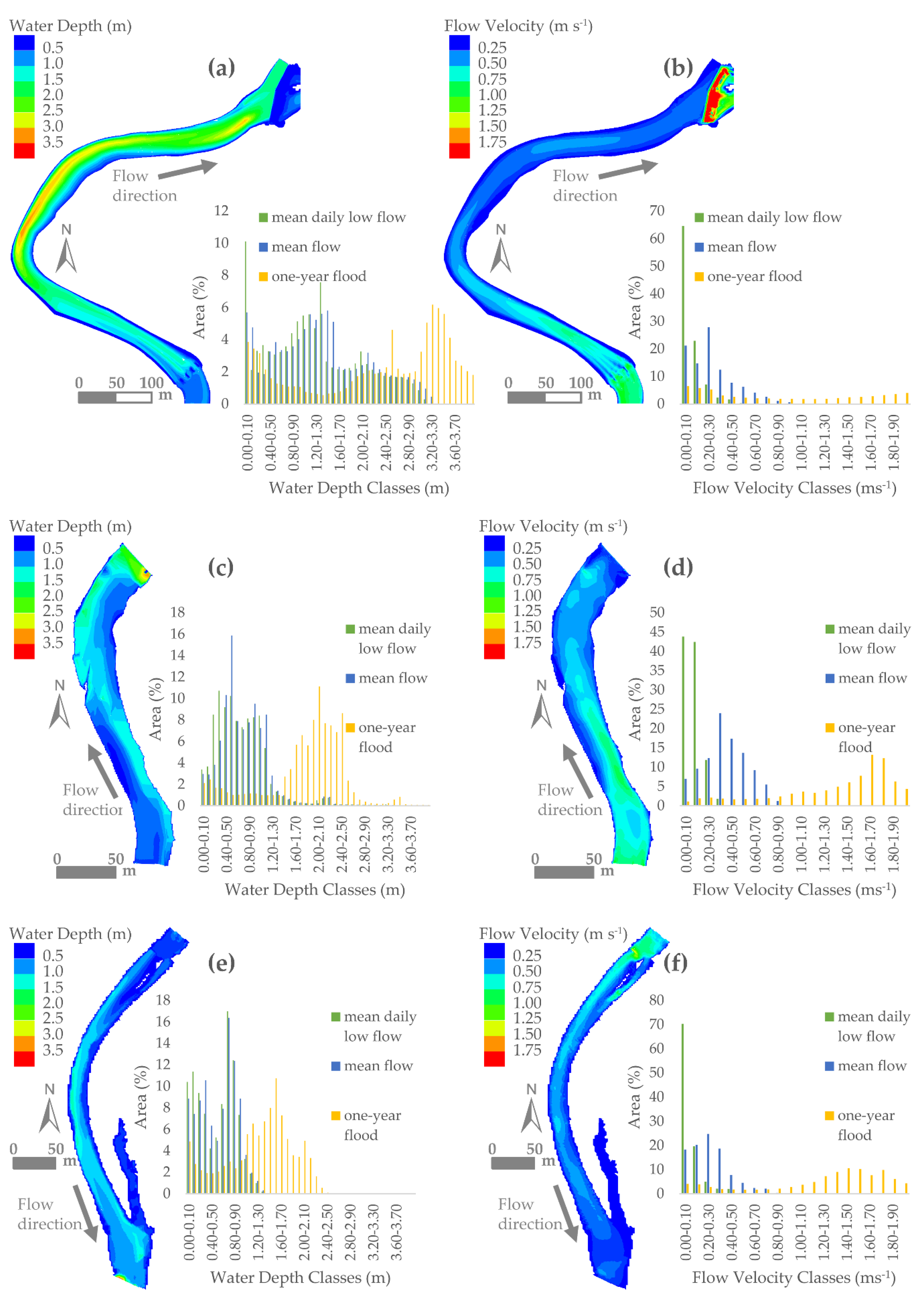
The hydrodynamic simulations reveal increasing water depths in flow direction in all study reaches (n = 3) with the highest values in the vicinity of the weirs (shown for mean flow conditions in Figure 5). Moreover, increased water depths can be identified in the outer bends of the river stretches (e.g., C.1, C.2, Figure 5a,c). In C.2 and C.3, depending on the discharge, water depths of less than 1.3 m prevail with the highest water depths up to 2.5 m during a one-year flood (Figure 5c,e). In contrast, the water depth distribution in C.1 is more heterogeneous. The water depth classes take values up to 3.2 m during mean daily low flow conditions. The largest part of the investigated reach, however, ranges around 1.3 m at mean daily low flow conditions and rises to 3.5 m at a one-year flood. Mean water depths in the impounded stretch range from 0.61 m (QL) to 2.43 m (QH) with standard deviations of 0.34 m up to 1.15 m, respectively (Table 5).
The flow velocity distribution in the study reaches show decreasing values from upstream to downstream, with the lowest values in the vicinity of the weirs (Figure 5b,d,f). Flow velocities of 0.3 m s−1 to 0.7 m s−1 are obtained for mean daily low flow and mean flow conditions (Figure 5b,d,f). It is also visible that the flow velocities in two reaches (C.2, C.3) increase significantly during a one-year flood, while, in one section (C.1), the distribution is much more heterogeneous (Figure 5b,d,f). Mean flow velocities are in the range of 0.21 m s−1 (QL) to 1.76 m s−1 (QH), with standard deviations from 0.19 m s−1 up to 1.30 m s−1 (Table 5).

3.3. Impoundment Assessment

The evaluation, according to the overall assessment method, shows discharge-dependent results for predicting the ecological status (Figure 6). Moreover, it can be seen that the assessment of the ecological status depends on the flow velocity (cf. Figure 5b,d,f). The reduced flow velocity due to the impoundment causes a worse ecological status (moderate or poor) in the vicinity of the weirs, compared to the free flowing sections in the upstream areas (C.1, C.3, Figure 6a,e) as well as in the areas next to banks (Figure 6a,c,e). Furthermore, a poor or bad ecological status is predicted during mean annual low flow for all investigated stretches. However, the predicted river length ecologically impacted by the impoundment is smaller than the impoundment length according to the National Water Management Plan (Table 6) for discharges higher than mean flow conditions. The impounded stretch in C.1 decreases compared to the length according to the National Water Management Plan depending on the discharge to 460 m (QL: reduction by 8%) and 420 m (QM: reduction by 16%), respectively, and disappears at high flow (QH). Similar results can be shown for C.2 (QL: 130 m (reduction by 57%), QM: 15 m (reduction by 95%) and QH: 0 m), and C.3 (QL: 421 m (no reduction), QM: 115 m (reduction by 73%) and QH: 0 m) (Table 6). The assessment according to the saprobic index yields better results with moderate or poor ecological status in the near-bank area, where the lowest flow velocities occur (Figure 6b,d,f). Additionally, the influence of flow velocities on the predicted saprobic condition of the river stretches can be seen. The evaluation of mean daily low flow up to a one-year flood yields an increase of the good ecological status with increasing discharge as well as a decrease of the ecologically poor areas. Using the saprobic index, the predicted impoundment length is zero for all reaches and discharge conditions investigated.

4. Discussion

The novel predictive HEM Impoundment Tool addresses important issues in the management of small hydropower plants on an international scale. Sediment management for small hydropower plants was, so far, associated with flushing [9], dredging [47], impacts of fine sediment deposition and pollution [48], or general discussions about the sediment continuity [49]. The new evaluation approach here, however, addresses and supports two main components in small hydropower plant design and river development. First, a run-of-the-river (small) hydropower plant is designed to use the amount of incoming discharge for electricity production (minus discharge rates for fish-pass and residual flow) [50]. Thus, from this technical point of view, there is no need for impounded sections to attain certain water depths, certain impounded water volumes, or to be designed as reservoirs in general. The second component, which is supported in this new evaluation approach, is related to basic driving forces in fluvial morphology, where rivers try to establish an equilibrium status (cf. [51]), depending on eight major variables, e.g., slope, grain size, and discharge [52]. In order to achieve more river-like conditions, sedimentation rates, however, must exceed a certain critical status before they are beneficial for the aquatic environment. First, fine sediment deposits related to low flow velocities are more likely, which shows negative developments concerning macro-invertebrate abundance and biomass [53]. Depending on incoming sediment fluxes (also depending on grain size), however, the impounded sections will develop step-by-step towards an equilibrium state. This is leading to favorable conditions for benthic organisms, as it could be presented for the three selected study sites.
In addition to the benefits for macro-invertebrates, the deposits of coarser sediment such as gravel were also positively evaluated for yielding local scale improvements for spawning of salmonid fish species. Salmonid rivers in Austria are considerably regulated by small hydropower facilities, which results in potential declines of the spawning habitats of salmonids. To assess the restrictions and possible quality of hydropower-influenced river sections for salmonid spawning, red densities of brown trout and rainbow trout were monitored in two rivers in 2014 and 2015 [54]. The assessments of spawning red densities enabled a discussion of different opportunities for spawning habitat enhancement of salmonids in river sections regulated by small hydropower facilities. In conclusion, it was found that the fill-up of the backwater sites by transported sediments or the structural modification (e.g., boulder placement) in the tail of the backwater could improve the spawning situation in a sustainable way [54].
The evident ecological benefits for macro-invertebrates and fish based on coarse material deposits in impounded sections, however, have to be discussed concerning technical requests of the hydropower plant facility. Both (i) flood protection and (ii) water supply to the turbine are crucial issues, which need to be guaranteed and maintained in terms of adaptive sediment management if needed. Adaptive sediment management would include dredging as well as flushing and sluicing. However, based on numerical sediment transport modelling [31,55,56], threshold conditions for both active management and self-forming equilibrium status may be predicted and evaluated. Hence, improvement of various, small hydropower plant sites will be possible using the novel predictive HEM Impoundment Tool even if there is only a re-classification of the risk-assessment for failing the good ecological status, according to the EU Water Framework Directive. In the presented study, it could be shown that 16% to 95% of the impoundment length was predicted to be in a good ecological status concerning the macro-invertebrate assessment method for mean discharge (QM). For low flow (QL), however, the ecological status predicted by the HEM Impoundment Tool corresponds to the data presented in the National Water Management Plan in terms of the length of the impounded section. This dataset is based on a mapping approach [57] where low-flow conditions (low water depth and turbidity) are required to achieve the requested visibility for mapping.
Besides hydro-morphology, water chemistry is highly important for the ecological status of a waterbody. Organic pollution, however, is only a minor issue in the river sections studied. Initial investigations show that changes in the river type-specific nutrient cycle are of minor importance. In particular, the quality problems described in literature due to low oxygen supply or changes in light conditions in deep reservoirs [58,59,60,61] do not occur in dammed areas with only low water depth. The results of the study by Ofenböck et al. [32] are based on the investigation of sensitive taxa and suggest that the flow velocities are sufficiently high despite impoundment. The predicted good saprobic index is also evident from the assessment in the national water management plan.
Hence, focusing on flow and hydromorphology, the question is: Is the macroinvertebrate community driven by low-flow conditions or are mean flow conditions a better predictor for the macro-invertebrate abundance and biomass? Thus, validation of the presented predictive modelling approach is needed. Consequently, a research campaign was started within the Christian Doppler Laboratory “Sediment research and management” to validate the dataset of Ofenböck et al. [32] used for setting up the HEM Impoundment model. Moreover, besides the validation, it is targeted to consider various geological and climatic settings in the follow-up biotic studies, as they are important for macro-invertebrate abundance and biomass [62]. This extended dataset should contribute to the reduction of uncertainties in relation to the application of HEM Impoundment to various river and hydropower plant sites. Uncertainties in the presented study are given to a minor extent in the numerical simulations due to (i) exclusion of the overbank areas, which would be slightly inundated in some of the annual-flood modelling scenarios, and (ii) the exclusion of the flow through the turbine intake. Thus, minor deviations in flow velocities might be present upstream of the weirs for all tested sites.

5. Conclusions

The presented novel prediction tool HEM Impoundment aggregates observed grain sizes and depth-averaged flow velocities resulting from a hydrodynamic simulation to perform an assessment of the ecological status of impounded river reaches. The parameters used were shown in literature to correlate with the abundance of benthic macroinvertebrates. Since this approach allows a detailed analysis of the entire wetted area discretized by computation nodes, river lengths as well as areas and area fractions are obtained, which are predicted to be ecologically affected by the impoundment. The results for reaches influenced by hydropower structures show that the impoundment lengths predicted to be in a moderate to bad ecological status under mean flow conditions were substantially shorter when compared to the officially published data. During low flow conditions, the predicted results matched the official database, which is explained by the origin of the data following a mapping approach, which requires small water depths and flow velocities. This means, in conclusion, that the application of the HEM Impoundment Tool allows the prediction of the ecological status of an impounded reach for hydrodynamic conditions that are well beyond the in-situ observable range and can be seen as complementary. However, currently, the application of the tool is restricted to impoundments for which no issues of water chemistry exist. In order to widen the scope of the tool in the future, additional components addressing these environmental properties can be added. Combined with a sediment transport and morphodynamics model, the ecological assessment of sediment management strategies at hydropower plant sites is a promising future application of HEM Impoundment.

Supplementary Materials

The following are available online at https://www.mdpi.com/2073-4441/12/4/1045/s1, Figure S1: Correlation grain size d50—flow velocity.

Author Contributions

Conceptualization, M.T. and C.H. Methodology, M.T. and C.H. Software, M.T. Validation, M.T., P.F., and C.H. Formal analysis, C.H. and M.T. Investigation, P.F. and M.T. Data curation, P.F. Writing—original draft preparation, M.T., P.F., and C.H. Writing—review and editing, M.T., C.H., and H.H. Visualization, P.F. Funding acquisition, C.H. and H.H. All authors have read and agreed to the published version of the manuscript.

Funding

This paper was written as a contribution to the Christian Doppler Laboratory for Sediment Research and Management. The financial support by the Christian Doppler Research Association, the Austrian Federal Ministry for Digital and Economic Affairs, and the Austrian National Foundation for Research, Technology, and Development is gratefully acknowledged.

Acknowledgments

The authors would like to express their gratitude toward Adrian Brinkmann, Florentina Freiberger, and Max Preiml for their contributions to field work and computational mesh generation.

Conflicts of Interest

The authors declare no conflict of interest.

References

  1. Newson, M.D.; Large, A.R.G. ‘Natural’ rivers, ‘hydromorphological quality’ and river restoration: A challenging new agenda for applied fluvial geomorphology. Earth Surf. Process. Landf. 2006, 31, 1606–1624. [Google Scholar] [CrossRef]
  2. Shearer, K.; Hayes, J.; Jowett, I.; Olsen, D. Habitat suitability curves for benthic macroinvertebrates from a small New Zealand river. N. Z. J. Mar. Freshw. Res. 2015, 49, 178–191. [Google Scholar] [CrossRef]
  3. Graf, W.; Leitner, P.; Hanetseder, I.; Ittner, L.D.; Dossi, F.; Hauer, C. Ecological degradation of a meandering river by local channelization effects: A case study in an Austrian lowland river. Hydrobiologia 2016, 772, 145–160. [Google Scholar] [CrossRef]
  4. Quinn, J.M.; Davies-Colley, R.J.; Hickey, C.W.; Vickers, M.L.; Ryan, P.A. Effects of clay discharges on streams: 2. Benthic invertebrates. Hydrobiologia 1992, 248, 235–247. [Google Scholar] [CrossRef]
  5. Buddensiek, V. The culture of juvenile freshwater pearl mussels Margaritifera margaritifera L. in cages: A contribution to conservation programmes and the knowledge of habitat requirements. Biol. Conserv. 1995, 74, 33–40. [Google Scholar] [CrossRef]
  6. Evans, E.; Wilcox, A.C. Fine sediment infiltration dynamics in a gravel-bed river following a sediment pulse. River Res. Appl. 2014, 30, 372–384. [Google Scholar] [CrossRef]
  7. Rabení, C.F.; Doisy, K.E.; Zweig, L.D. Stream invertebrate community functional responses to deposited sediment. Aquat. Sci. 2005, 67, 395–402. [Google Scholar] [CrossRef]
  8. Leitner, P.; Hauer, C.; Ofenböck, T.; Pletterbauer, F.; Schmidt-Kloiber, A.; Graf, W. Fine sediment deposition affects biodiversity and density of benthic macroinvertebrates: A case study in the freshwater pearl mussel river Waldaist (Upper Austria). Limnologica 2015, 50, 54–57. [Google Scholar] [CrossRef]
  9. Crosa, G.; Castelli, E.; Gentili, G.; Espa, P. Effects of suspended sediments from reservoir flushing on fish and macroinvertebrates in an alpine stream. Aquat. Sci. 2010, 72, 85–95. [Google Scholar] [CrossRef]
  10. Gray, L.J.; Ward, J.V. Effects of sediment releases from a reservoir on stream macroinvertebrates. Hydrobiologia 1982, 96, 177–184. [Google Scholar] [CrossRef]
  11. Kaller, M.D.; Hartman, K.J. Evidence of a threshold level of fine sediment accumulation for altering benthic macroinvertebrate communities. Hydrobiologia 2004, 518, 95–104. [Google Scholar] [CrossRef]
  12. Bovee, K.D. Development and Evaluation of Habitat Suitability Criteria for Use in the Instream Flow Incremental Methodology; USDI Fish and Wildlife Service: Washington, DC, USA, 1986. [Google Scholar]
  13. Shirvell, C.S. Ability of phabsim to predict chinook salmon spawning habitat. Regul. Rivers Res. Manag. 1989, 3, 277–289. [Google Scholar] [CrossRef]
  14. Jowett, I.G.; Richardson, J.; Biggs, B.J.F.; Hickey, C.W.; Quinn, J.M. Microhabitat preferences of benthic invertebrates and the development of generalised Deleatidium spp. habitat suitability curves, applied to four New Zealand rivers. N. Z. J. Mar. Freshw. Res. 1991, 25, 187–199. [Google Scholar] [CrossRef] [Green Version]
  15. Gore, J.A.; Crawford, D.J.; Addison, D.S. An analysis of artificial riffles and enhancement of benthic community diversity by physical habitat simulation (PHABSIM) and direct observation. Regul. Rivers Res. Manag. 1998, 14, 69–77. [Google Scholar] [CrossRef]
  16. Jerves-Cobo, R.; Everaert, G.; Iñiguez-Vela, X.; Córdova-Vela, G.; Díaz-Granda, C.; Cisneros, F.; Nopens, I.; Goethals, P. A Methodology to Model Environmental Preferences of EPT Taxa in the Machangara River Basin (Ecuador). Water 2017, 9, 195. [Google Scholar] [CrossRef] [Green Version]
  17. Jerves-Cobo, R.; Córdova-Vela, G.; Iñiguez-Vela, X.; Díaz-Granda, C.; Van Echelpoel, W.; Cisneros, F.; Nopens, I.; Goethals, P. Model-Based Analysis of the Potential of Macroinvertebrates as Indicators for Microbial Pathogens in Rivers. Water 2018, 10, 375. [Google Scholar] [CrossRef] [Green Version]
  18. Li, K.; He, C.; Zhuang, J.; Zhang, Z.; Xiang, H.; Wang, Z.; Yang, H.; Sheng, L. Long-Term Changes in the Water Quality and Macroinvertebrate Communities of a Subtropical River in South China. Water 2014, 7, 63–80. [Google Scholar] [CrossRef] [Green Version]
  19. Li, F.; Cai, Q.; Fu, X.; Liu, J. Construction of habitat suitability models (HSMs) for benthic macroinvertebrate and their applications to instream environmental flows: A case study in Xiangxi River of Three Gorges Reservior region, China. Prog. Nat. Sci. 2009, 19, 359–367. [Google Scholar] [CrossRef]
  20. Smith, M.J.; Kay, W.R.; Edward, D.H.D.; Papas, P.J.; Richardson, K.S.J.; Simpson, J.C.; Pinder, A.M.; Cale, D.J.; Horwitz, P.H.J.; Davis, J.A.; et al. AusRivAS: Using macroinvertebrates to assess ecological condition of rivers in Western Australia. Freshw. Biol. 1999, 41, 269–282. [Google Scholar] [CrossRef]
  21. Meixler, M.S.; Bain, M.B. Modeling Aquatic Macroinvertebrate Richness Using Landscape Attributes. Int. J. Ecol. 2015, 2015, 1–14. [Google Scholar] [CrossRef] [Green Version]
  22. Kim, D.-H.; Chon, T.-S.; Kwak, G.-S.; Lee, S.-B.; Park, Y.-S. Effects of Land Use Types on Community Structure Patterns of Benthic Macroinvertebrates in Streams of Urban Areas in the South of the Korea Peninsula. Water 2016, 8, 187. [Google Scholar] [CrossRef] [Green Version]
  23. Hauer, C.; Mandlburger, G.; Habersack, H. Hydraulically related hydro-morphological units: Description based on a new conceptual mesohabitat evaluation model (MEM) using LiDAR data as geometric input. River Res. Appl. 2009, 25, 29–47. [Google Scholar] [CrossRef]
  24. Habersack, H.; Tritthart, M.; Liedermann, M.; Hauer, C. Efficiency and uncertainties in micro- and mesoscale habitat modelling in large rivers. Hydrobiologia 2014, 729, 33–48. [Google Scholar] [CrossRef]
  25. Hauer, C.; Unfer, G.; Graf, W.; Leitner, P.; Zeiringer, B.; Habersack, H. Hydro-morphologically related variance in benthic drift and its importance for numerical habitat modelling. Hydrobiologia 2012, 683, 83–108. [Google Scholar] [CrossRef]
  26. Theodoropoulos, C.; Skoulikidis, N.; Stamou, A.; Dimitriou, E. Spatiotemporal Variation in Benthic-Invertebrates-Based Physical Habitat Modelling: Can We Use Generic Instead of Local and Season-Specific Habitat Suitability Criteria? Water 2018, 10, 1508. [Google Scholar] [CrossRef] [Green Version]
  27. Zhang, Y. CCHE2D – User’s Manual – Version 2.210; National Center for Computational Hydroscience and Engineering: Oxford, MS, USA, 2006. [Google Scholar]
  28. DHI Water & Environment. MIKE 21 Flow Model & MIKE 21 FloodScreening Tool: Hydrodynamic Module-Scientific Documentation; DHI: Hørsholm, Denmark, 2017. [Google Scholar]
  29. Steffler, P.; Blackburn, J. River2D-Two-Dimensional Depth Averaged Model of River Hydrodynamics and Fish Habitat: Introduction to Depth Averaged Modeling and User’s Manual; University of Alberta: Edmonton, AB, Canada, 2002. [Google Scholar]
  30. Nujic, M. Praktischer Einsatz eines hochgenauen Verfahrens für die Berechnung von tiefengemittelten Strömungen; Mitteilungen des Institutes der Bundeswehr München: Munich, Germany, 1999. [Google Scholar]
  31. Tritthart, M.; Liedermann, M.; Schober, B.; Habersack, H. Non-uniformity and layering in sediment transport modelling 2: River application. J. Hydraul. Res. 2011, 49, 335–344. [Google Scholar] [CrossRef]
  32. Ofenböck, T.; Graf, W.; Hartmann, A.; Huber, T.; Leitner, P.; Stubauer, I.; Moog, O. Abschätzung des ökologischen Zustandes von Stauen auf Basis von Milieufaktoren; Bundesministerium für Land- und Forstwirtschaft, Umwelt und Wasserwirtschaft: Vienna, Austria, 2011. [Google Scholar]
  33. BMLFUW. Qualitätszielverordnung Ökologie Oberflächengewässer-Vorgaben zur Beurteilung des ökologischen Zustands von Oberflächengewässern; Austrian Federal Ministry for Agriculture, Forestry, Environment and Water Management (BMLFUW): Vienna, Austria, 2010. [Google Scholar]
  34. Zelinka, M.; Marvan, P. Zur Präzisierung der biologischen Klassifikation der Reinheit fließender Gewässer. Arch Hydrobiol 1961, 57, 384–407. [Google Scholar]
  35. Leitner, P.; Hauer, C.; Graf, W. Habitat use and tolerance levels of macroinvertebrates concerning hydraulic stress in hydropeaking rivers — A case study at the Ziller River in Austria. Sci. Total Environ. 2017, 575, 112–118. [Google Scholar] [CrossRef]
  36. Holzapfel, P.; Leitner, P.; Habersack, H.; Graf, W.; Hauer, C. Evaluation of hydropeaking impacts on the food web in alpine streams based on modelling of fish- and macroinvertebrate habitats. Sci. Total Environ. 2017, 575, 1489–1502. [Google Scholar] [CrossRef]
  37. Diplas, P.; Kuhnle, R.; Gray, J.; Glysson, D.; Edwards, T. Sediment Transport Measurements. In Sedimentation Engineering: Processes, Measurements, Modeling, and Practice; American Society of Civil Engineers: Reston, VA, USA, 2008; pp. 305–351. ISBN 978-0-7844-0814-8. [Google Scholar]
  38. Pironneau, O. Finite Element Methods for Fluids; Wiley: New York, NY, USA, 1989. [Google Scholar]
  39. Tritthart, M.; Hauer, C.; Liedermann, M.; Habersack, H. Computer-aided mesohabitat evaluation, part II – model development and application in the restoration of a large river. In International Conference on Fluvial Hydraulics, River Flow 2008; KUBABA Congress Department and Travel Services: Izmir, Turkey, 2008; pp. 1885–1893. [Google Scholar]
  40. Hauer, C.; Unfer, G.; Tritthart, M.; Formann, E.; Habersack, H. Variability of mesohabitat characteristics in riffle-pool reaches: Testing an integrative evaluation concept (FGC) for MEM-application. River Res. Appl. 2011, 27, 403–430. [Google Scholar] [CrossRef]
  41. Hauer, C.; Unfer, G.; Schmutz, S.; Habersack, H. Morphodynamic Effects on the Habitat of Juvenile Cyprinids (Chondrostoma nasus) in a Restored Austrian Lowland River. Environ. Manage. 2008, 42, 279–296. [Google Scholar] [CrossRef] [PubMed]
  42. Dewson, Z.S.; James, A.B.W.; Death, R.G. A review of the consequences of decreased flow for instream habitat and macroinvertebrates. J. N. Am. Benthol. Soc. 2007, 26, 401–415. [Google Scholar] [CrossRef]
  43. Monk, W.A.; Wood, P.J.; Hannah, D.M.; Wilson, D.A.; Extence, C.A.; Chadd, R.P. Flow variability and macroinvertebrate community response within riverine systems. River Res. Appl. 2006, 22, 595–615. [Google Scholar] [CrossRef] [Green Version]
  44. Lamouroux, N.; Doledec, S.; Gayraud, S. Biological traits of stream macroinvertebrate communities: Effects of microhabitat, reach, and basin filters. J. N. Am. Benthol. Soc. 2004, 23, 449–466. [Google Scholar] [CrossRef]
  45. Dolédec, S.; Lamouroux, N.; Fuchs, U.; Mérigoux, S. Modelling the hydraulic preferences of benthic macroinvertebrates in small European streams. Freshw. Biol. 2007, 52, 145–164. [Google Scholar] [CrossRef]
  46. Ofenböck, T.; Moog, O.; Hartmann, A.; Stubauer, I. Leitfaden zur Erhebung der Biologischen Qualitätselemente: Teil A2-Makrozoobenthos; Bundesministerium für Land- und Forstwirtschaft, Umwelt und Wasserwirtschaft: Vienna, Austria, 2010. [Google Scholar]
  47. Hauer, C.; Wagner, B.; Aigner, J.; Holzapfel, P.; Flödl, P.; Liedermann, M.; Tritthart, M.; Sindelar, C.; Pulg, U.; Klösch, M.; et al. State of the art, shortcomings and future challenges for a sustainable sediment management in hydropower: A review. Renew. Sustain. Energy Rev. 2018, 98, 40–55. [Google Scholar] [CrossRef]
  48. Todorova, Y.; Lincheva, S.; Yotinov, I.; Topalova, Y. Contamination and Ecological Risk Assessment of Long-Term Polluted Sediments with Heavy Metals in Small Hydropower Cascade. Water Resour. Manag. 2016, 30, 4171–4184. [Google Scholar] [CrossRef]
  49. Sindelar, C.; Schobesberger, J.; Habersack, H. Effects of weir height and reservoir widening on sediment continuity at run-of-river hydropower plants in gravel bed rivers. Geomorphology 2017, 291, 106–115. [Google Scholar] [CrossRef]
  50. Anagnostopoulos, J.S.; Papantonis, D.E. Optimal sizing of a run-of-river small hydropower plant. Energy Convers. Manag. 2007, 48, 2663–2670. [Google Scholar] [CrossRef]
  51. Thorne, C.R. Geomorphic analysis of large alluvial rivers. Geomorphology 2002, 44, 203–219. [Google Scholar] [CrossRef]
  52. Leopold, L.; Wolman, M.G.; Miller, J.P. Fluvial Processes in Geomorphology; Freeman: San Francisco, CA, USA, 1964; ISBN 978-0-7167-0221-4. [Google Scholar]
  53. Jones, J.I.; Murphy, J.F.; Collins, A.L.; Sear, D.A.; Naden, P.S.; Armitage, P.D. The Impact of Fine Sediment on Macro-Invertebrates. River Res. Appl. 2012, 28, 1055–1071. [Google Scholar] [CrossRef]
  54. Obruca, W.; Hauer, C. Abiotic Characterization of Brown Trout (Salmo trutta f. fario) and Rainbow Trout (Oncorhynchus mykiss) Spawning Redds Affected by Small Hydropower Plants—Case Studies from Austria. River Res. Appl. 2016, 32, 1989–1995. [Google Scholar] [CrossRef]
  55. Papanicolaou, A.N.; Elhakeem, M.; Krallis, G.; Prakash, S.; Edinger, J. Sediment transport modeling review-Current and future developments. J. Hydraul. Eng. 2008, 134, 1–14. [Google Scholar] [CrossRef]
  56. Tritthart, M.; Haimann, M.; Habersack, H.; Hauer, C. Spatio-temporal variability of suspended sediments in rivers and ecological implications of reservoir flushing operations. River Res. Appl. 2019, 35, 918–931. [Google Scholar] [CrossRef] [Green Version]
  57. Parasiewicz, P. MesoHABSIM: A concept for application of instream flow models in river restoration planning. Fisheries 2001, 26, 6–13. [Google Scholar] [CrossRef]
  58. Moog, O. Auswirkungen Anthropogener Eingriffe auf Aquatische Ökosysteme; Habilitationsschrift; Univ. f. Bodenkultur: Vienna, Austria, May 1990. [Google Scholar]
  59. Moog, O.; Jungwirth, M. Wasserkraft-Nutzung und Restwassermengen mit besonderer Berücksichtigung ökologischer Gesichtspunkte. Tagungsberichte 17. Flußbautagung 28.9.-2.10.1992; ÖWWV: Bregenz, Austria, 1992. [Google Scholar]
  60. Dolédec, S.; Dessaix, J.; Tachet, H. Changes within the Upper Rhône River macrobenthic communities after the completion of three hydroelectric schemes: Anthropogenic effects or natural change? Arch. Hydrobiol. 1996, 136, 19–40. [Google Scholar]
  61. Horeau, V.; Richard, S.; Vigouroux, R.; Guillemet, L.; Cerdan, P. The Petit Saut hydroelectric dam (French Guiana): Temporal and spatial variability of the water quality and pelagic invertebrates. Rev. Sci. Eau 2005, 18, 109–126. [Google Scholar]
  62. Li, J.; Herlihy, A.; Gerth, W.; Kaufmann, P.; Gregory, S.; Urquhart, S.; Larsen, D.P. Variability in stream macroinvertebrates at multiple spatial scales. Freshw. Biol. 2001, 46, 87–97. [Google Scholar] [CrossRef]
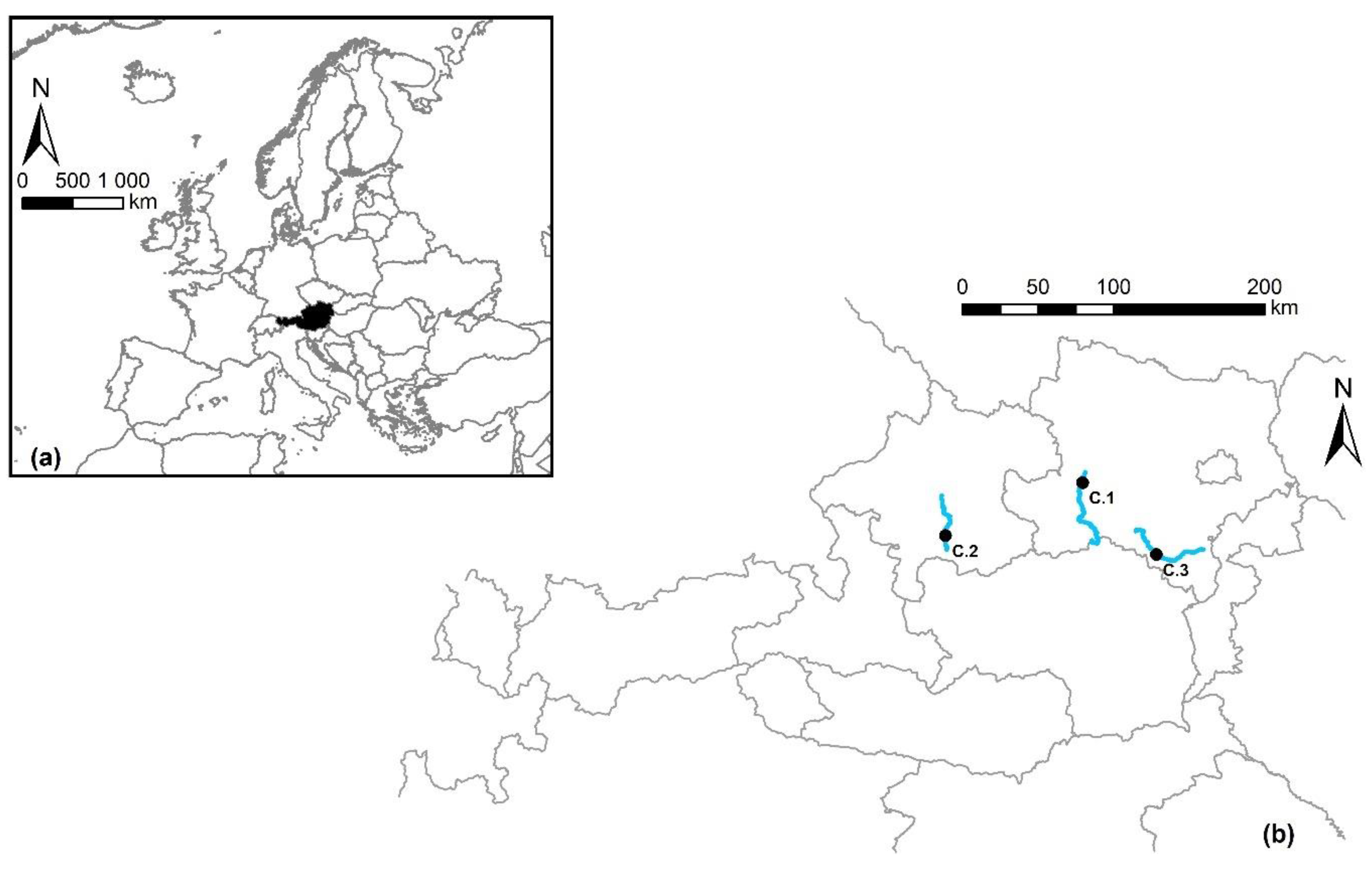
Figure 1. (a) European map and the Austrian territory (black). (b) Detailed overview of the three rivers (blue lines) and location of the case studies (black dots).
Water 12 01045 g001
Figure 2. Terrain elevation models of the three case studies: (a) Erlauf River (C.1), (b) Alm River (C.2), and (c) Schwarza River (C.3). Black line: bounds of the evaluation region.
Water 12 01045 g002
Figure 3. Results of the median diameter d50 (mm) of the surface layer (SL) and subsurface layer (SSL).
Water 12 01045 g003
Figure 4. Percentage of grain sizes less than 2 mm for the surface layer samples (SL) and subsurface layer samples (SSL).
Water 12 01045 g004
Figure 5. Results of the hydrodynamic simulations for investigated river stretches C.1 (a,b), C.2 (c,d), C.3 (e,f). Shown are water depths (a,c,e) and flow velocities (b,d,f) at mean flow conditions. Inset: class distributions for the three calculated discharges (QL, QM, QH).
Water 12 01045 g005
Figure 6. Results of the ecological status assessment. The overall assessment classification is shown in figure (a) (C.1), (c) (C.2), (e) (C.3). Results based on the saprobic index evaluation are shown in figure (b) (C.1), (d) (C.2), (f) (C.3).
Water 12 01045 g006
Table 1. Relevant hydrological parameters and description of the ecological status according to the Water Framework Directive (2000/60/EC).
Case StudyRiverCatchment Size (km²)1 QL (m³ s−1)2 QM (m³ s−1)3 QH (m³ s−1)4 Water Body Type5 Ecological Status
C.1Erlauf604.94.4314.70215.00HMWBModerate
C.2Alm181.92.439.18105.00NaturalModerate
C.3Schwarza252.31.585.1965.20NaturalGood
1 mean daily low flow, 2 mean flow, 3 flood with a return period of one year. 4 Water body type according to the Water Framework Directive (2000/60/EC): Natural Water Bodies or Heavily Modified Water Bodies (HMWB). 5 Ecological status of surface water bodies (Water Framework Directive 2000/60/EC).
Table 2. Assessment classes according to the median diameter d50 of bed sediment (modified after Reference [32]).
Grain Size GroupDiameter (cm)Ecological Status
Mesolithal (cobble)6.3–20Potentially good
Microlithal (pebble)2.0–6.3Potentially good
Akal (gravel)0.2–2.0Potentially good
Psammal (sand)0.063–0.2Likely bad
Pelal (silt)<0.063Likely bad
Table 3. Assessment classes according to flow velocities: overall assessment (modified after Reference [32]).
Flow Velocity (m s−1)Ecological Status
>0.35Good
0.25–0.35Moderate
0.15–0.25Poor
<0.15Bad
Table 4. Assessment classes according to flow velocities: saprobic index [34].
Flow Velocity (m s−1)Ecological Status
>0.20Good
0.10–0.20Moderate
<0.10Poor
Table 5. Summary of mean values ( x ¯ ) and related standard deviations (σ) of water depths (m) and flow velocities (m s−1).
Water Depth (m)Flow Velocity (m s−1)
QLQMQHQLQMQH
River Erlauf (C.1)( x ¯ )1.081.182.430.330.581.76
(σ)0.770.781.150.480.671.30
River Alm (C.2)( x ¯ )0.680.731.900.260.531.62
(σ)0.380.370.550.230.250.48
River Schwarza (C.3)( x ¯ )0.610.641.360.210.371.39
(σ)0.340.330.540.190.250.50
Table 6. Comparison of the predicted impoundment length (m), according to the overall assessment method, and the published length, according to the National Water Management Plan.
Case StudyDischargePredicted Impoundment LengthImpoundment Length in National Water Management Plan
C.1QL460502
QM420
QH0
C.2QL130300
QM15
QH0
C.3QL421421
QM115
QH0