Nossana Spring (Northern Italy) under Climate Change: Projections of Future Discharge Rates and Water Availability


Abstract
1. Introduction
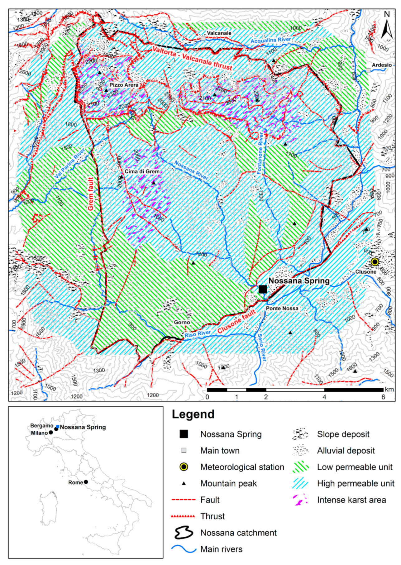
2. Study Area
3. Data
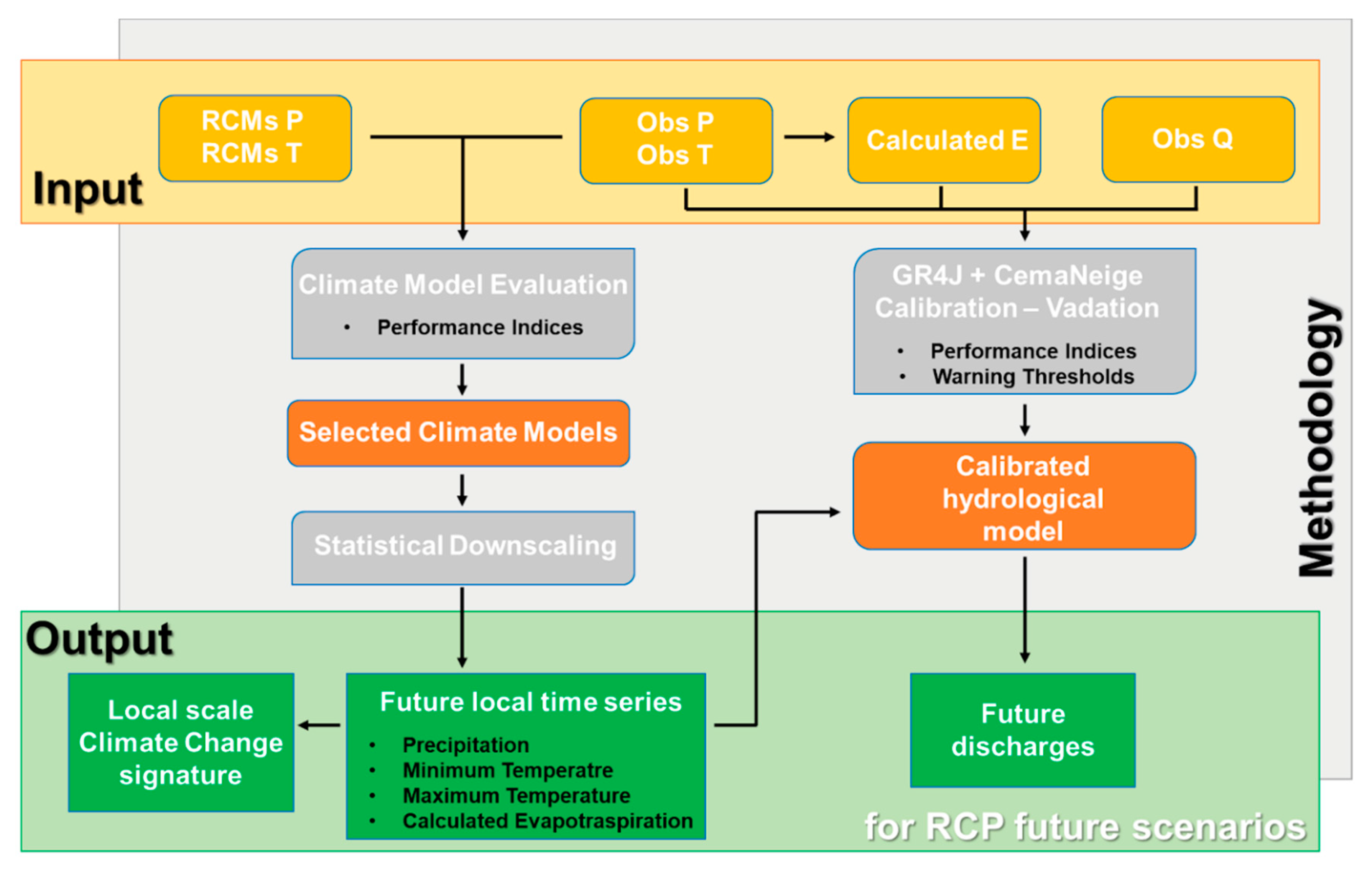
4. Methods
4.1. Climate Models Evaluation
4.2. Statistical Downscaling
4.2.1. Rainfall Generator
4.2.2. Temperature Generator
4.2.3. Evaluation of the Local Climate Change Signature
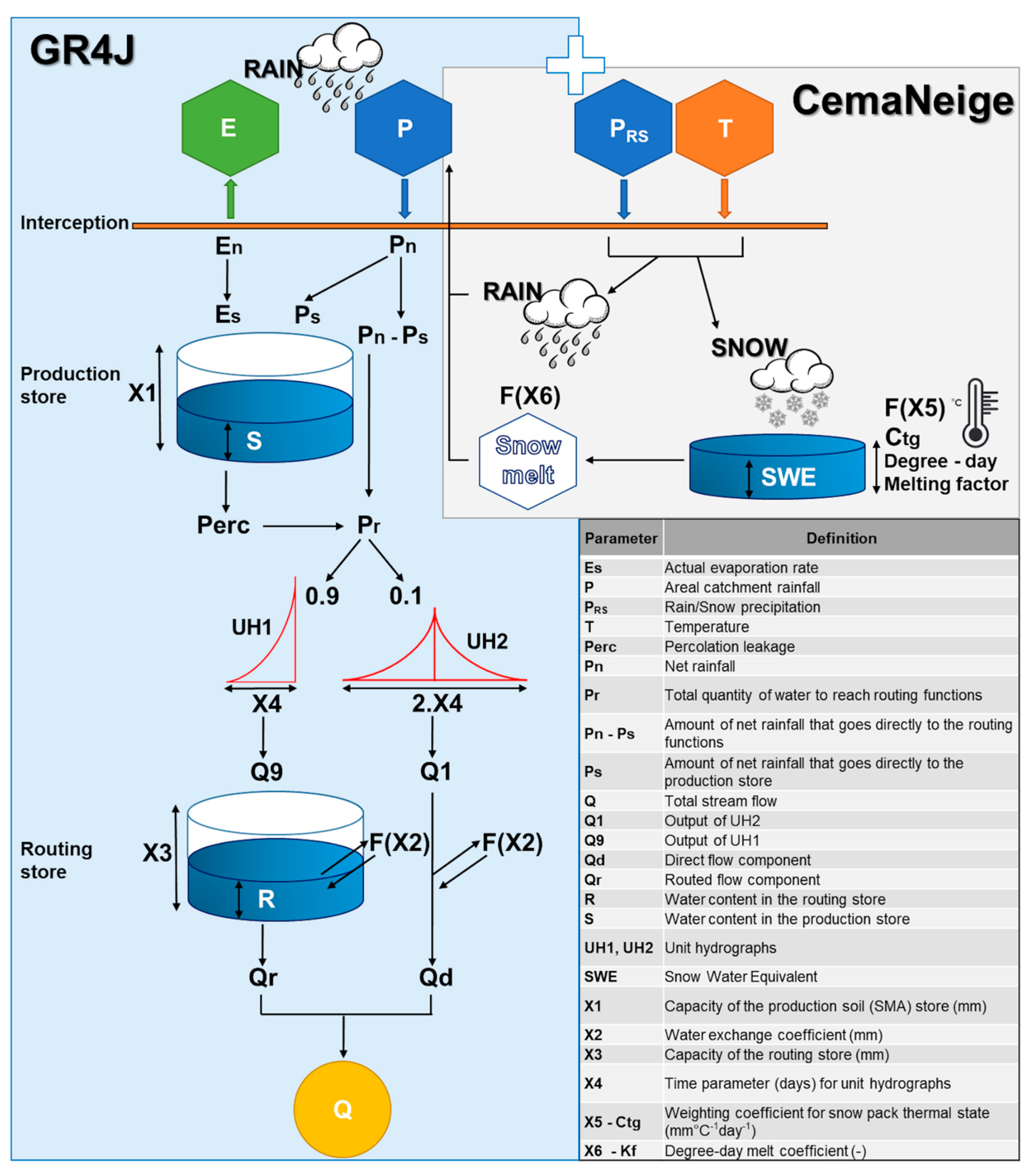
4.3. Hydrologic Modelling
4.3.1. Model Description
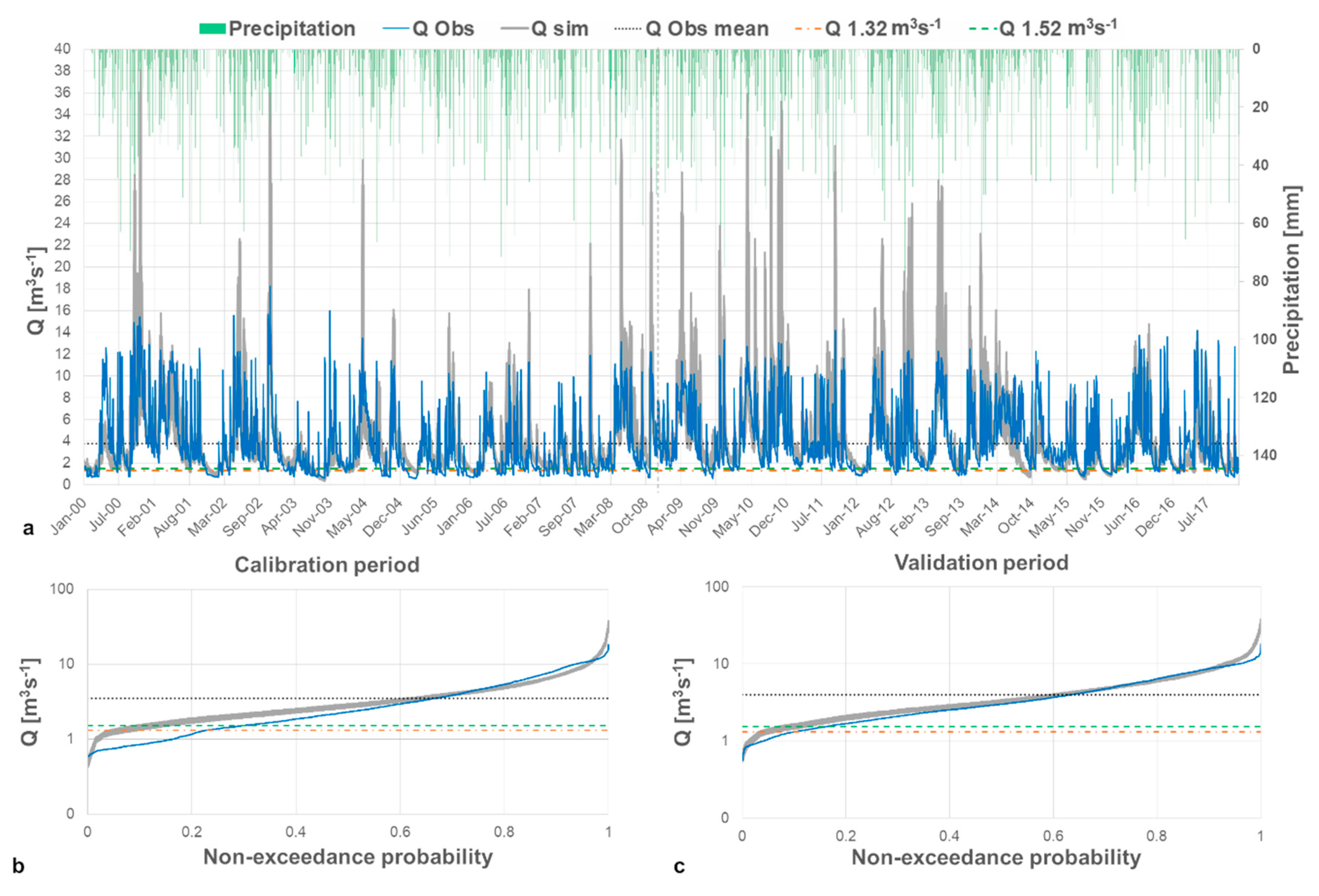
4.3.2. Model Calibration and Validation
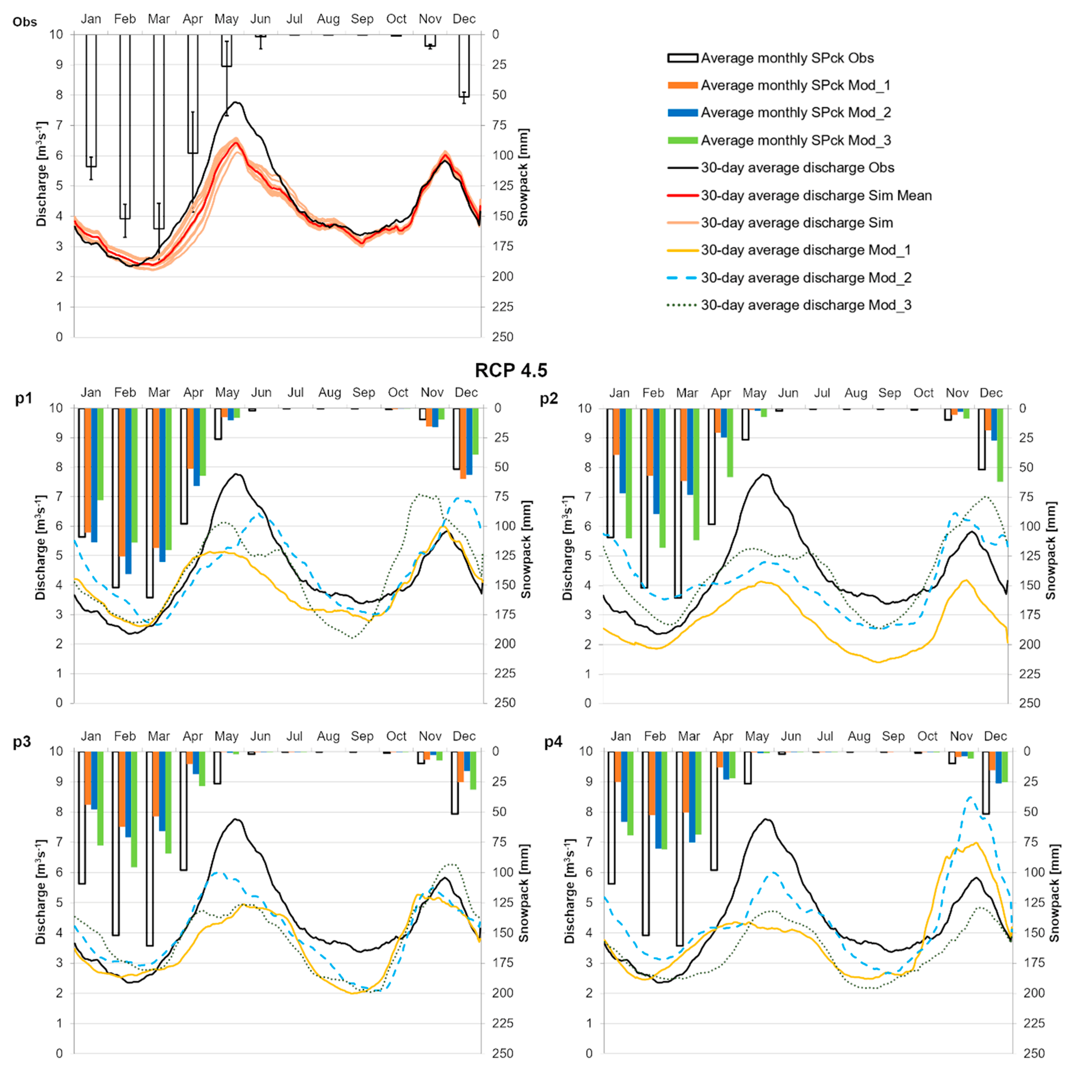
4.4. Changes in Discharge Regimes at Nossana Karst Spring
5. Results
5.1. Climate Models Evaluation
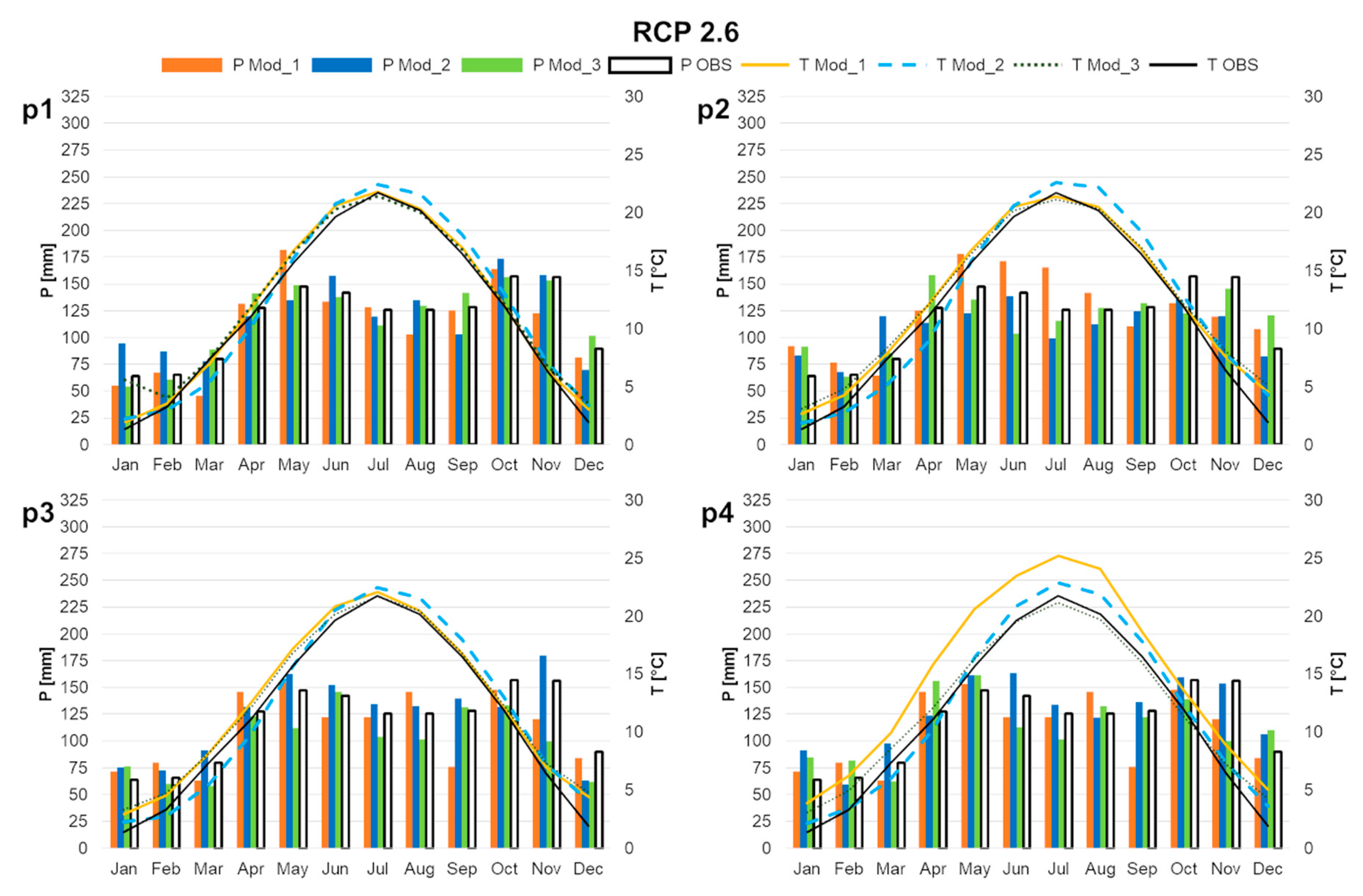
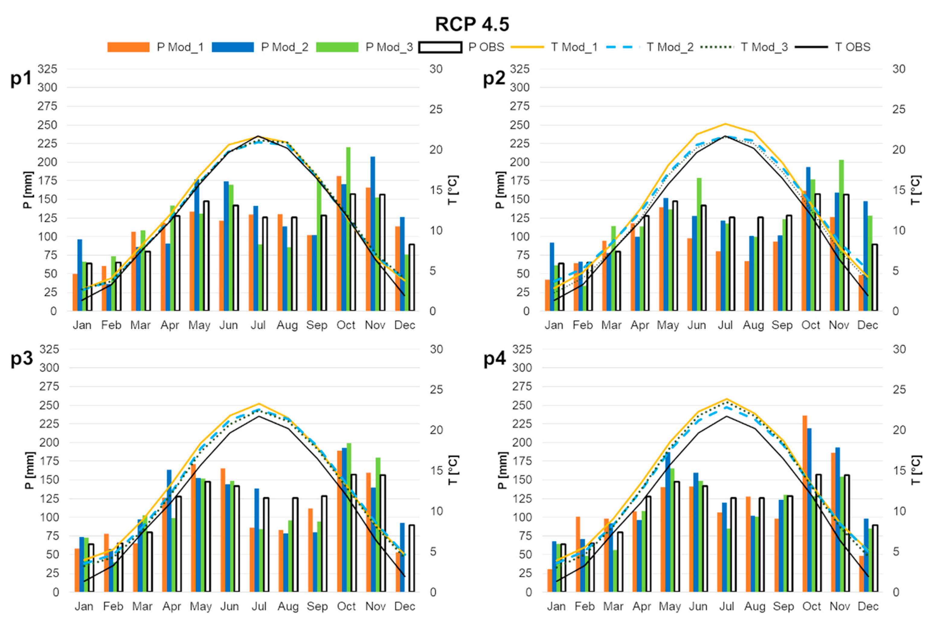
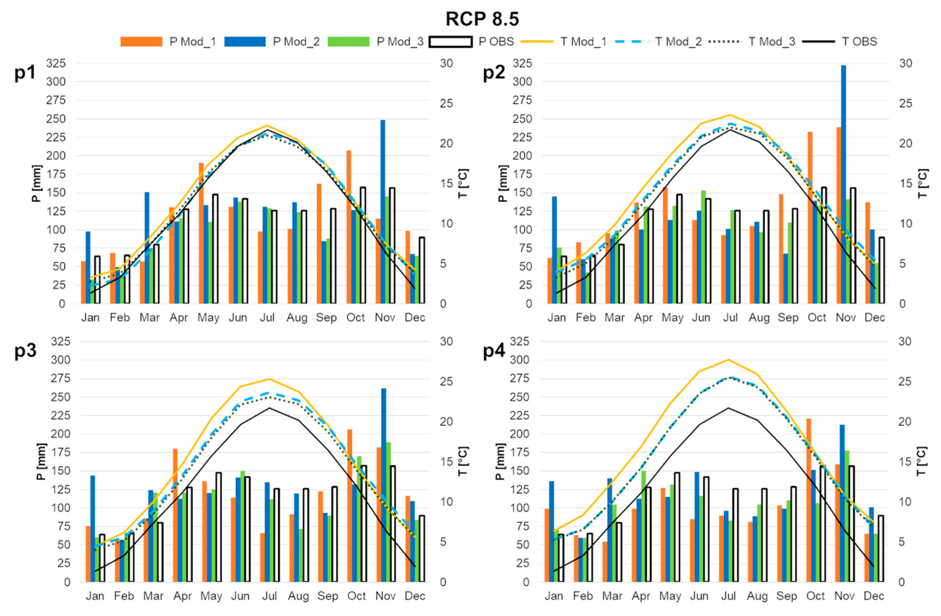
5.2. Statistical Downscaling—Local Climate Change Signature
5.3. Hydrologic Model Calibration and Validation
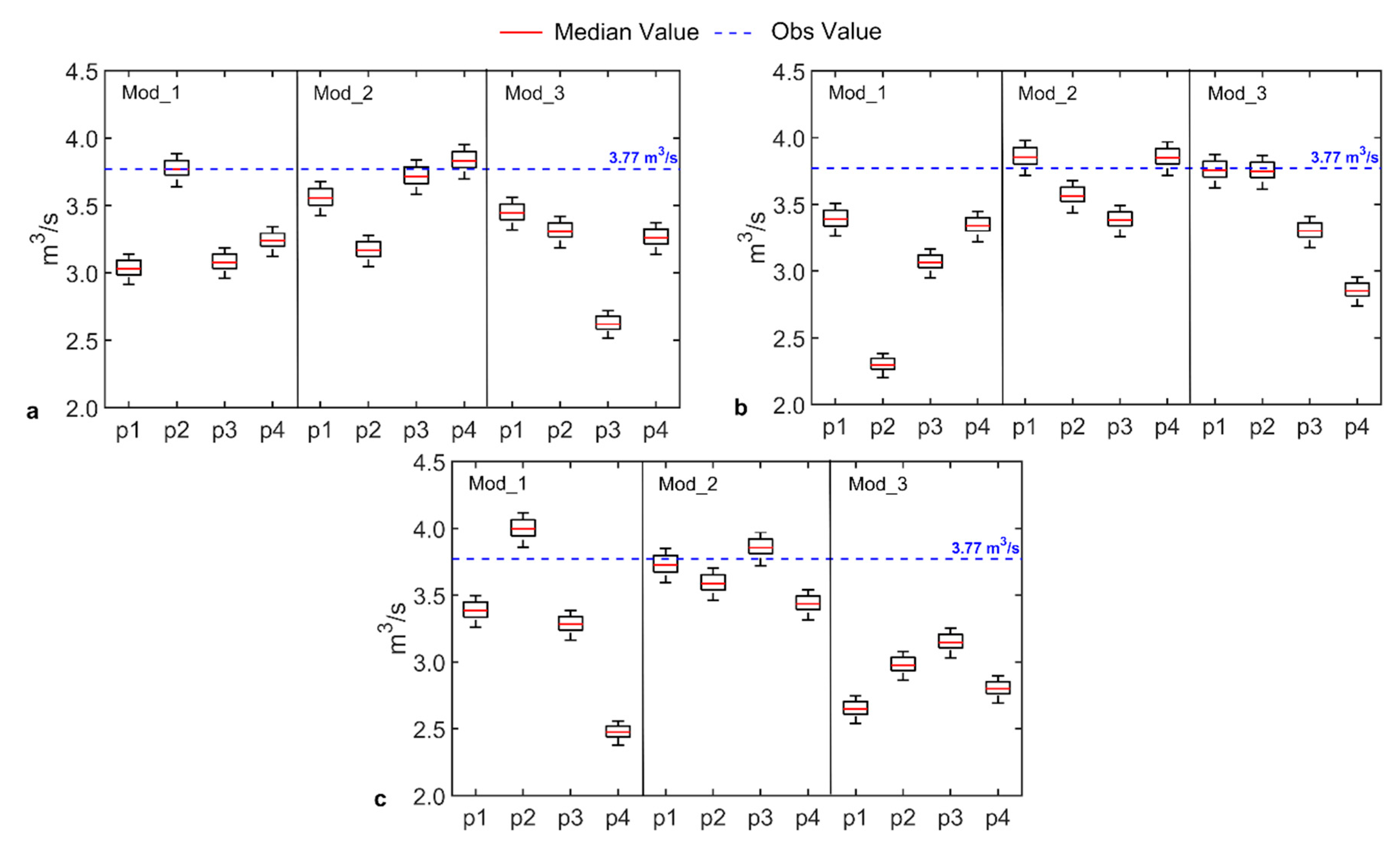
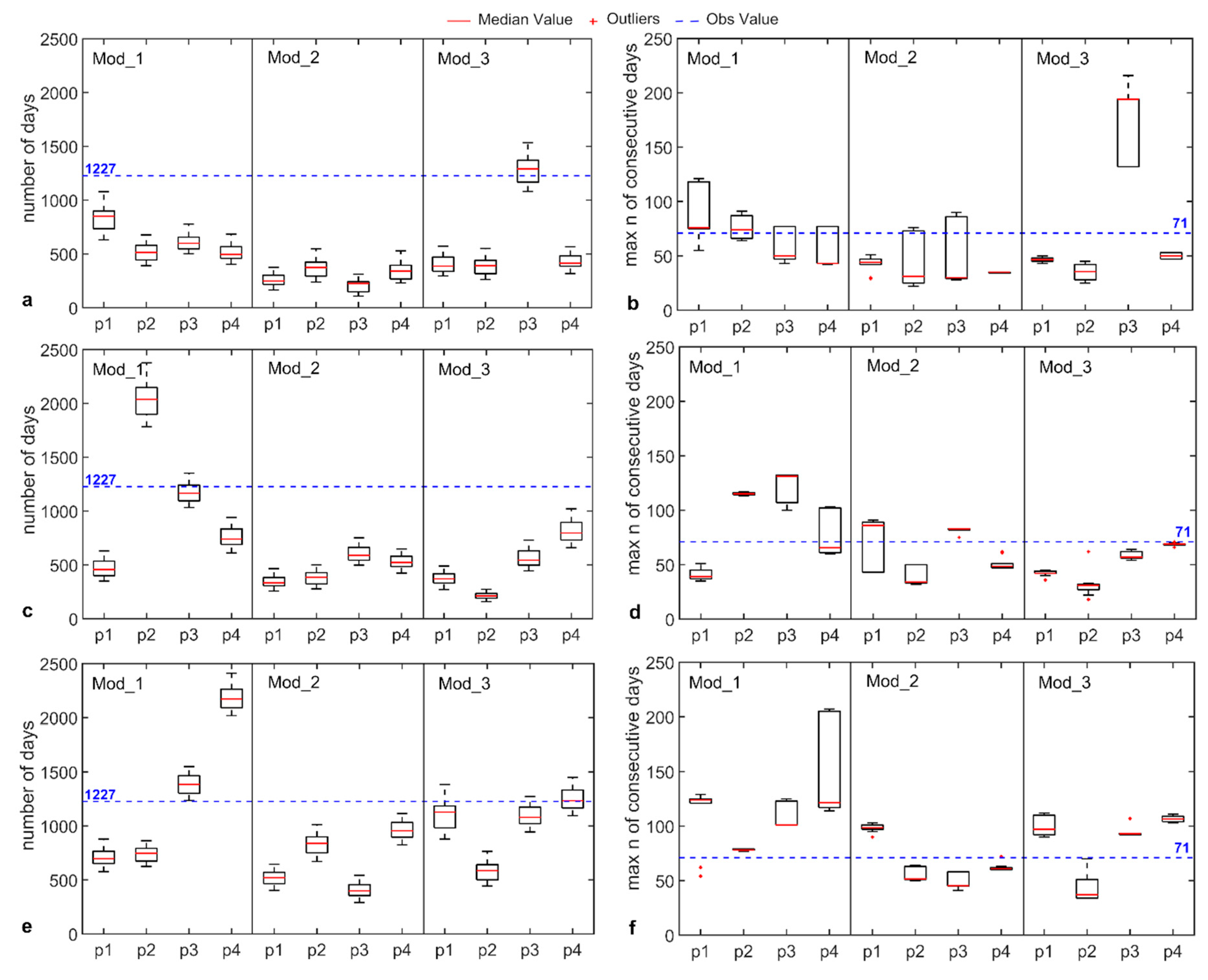
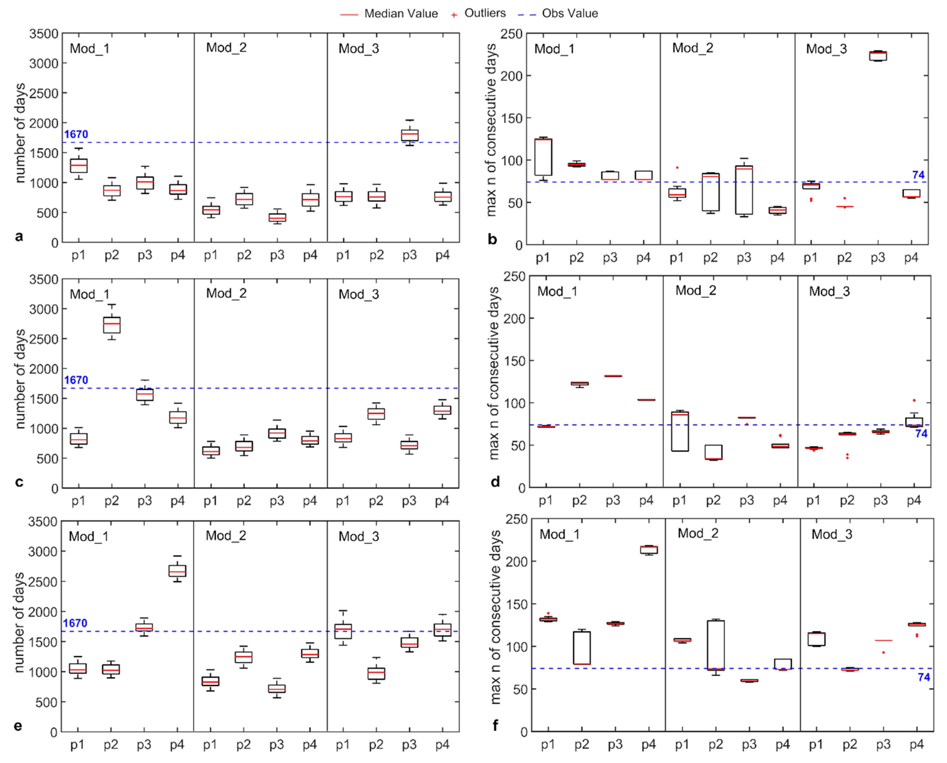
5.4. Changes in Discharge Regimes at Nossana Karst Spring
6. Discussion
7. Conclusions
- The considered bias-corrected EURO-CORDEX RCMs have very good skills in reproducing observed temperature climatology (NSE > 0.95 and relative MAE < 10%) over the study area, while larger errors persist regarding precipitation (NSE between 0.25 and 0.65, relative MAE between 10% and 20%);
- According to the downscaled RCMs data, in comparison to 1998–2017, mean temperature will likely increase throughout the rest of the XXI century, from 0.7 °C in 2021–2040 (RCP4.5, Mod_2) to 5.8 °C in 2081–2100 (RCP8.5, Mod_1);
- Downscaled RCMs data do not show a clear trend in precipitation. For all twenty-year periods and RCP scenarios, there are single RCMs projecting increasing and decreasing rainfall (except 2021–2040, RCP2.6, all increasing). Variations in mean annual rainfall varies between −18.5% (2041–2060, RCP4.5, Mod_2) and 15.1% (2041–2060, RCP8.5, Mod_2);
- A pronounced decrease of precipitation is expected in the summer period after 2060, as most RCM-RCP combinations show;
- Mean discharges are generally projected to decrease in comparison to observed flow (3.77 m3 s−1) since changes in mean annual precipitation usually do not balance increases in evapotranspiration rates due to higher temperatures;
- Variability in the projected mean discharges is mainly linked to the meteorological input rather than the rainfall-runoff model parameterization;
- The maximum number of consecutive days below the warning thresholds was recognized as the best index to evaluate the spring low flow conditions;
- After 2060, the length of the periods with discharge lower than the warning thresholds is expected to increase. These periods could last up to 64 days (86%) longer than in 1998–2017.
Author Contributions
Funding
Acknowledgments
Conflicts of Interest
References
- Bakalowicz, M. Karst groundwater: A challenge for new resources. Hydrogeol. J. 2005, 13, 148–160. [Google Scholar] [CrossRef]
- Core Writing Team; Pachauri, R.K.; Meyer, L.A. (Eds.) IPCC Climate Change 2014: Synthesis Report. Contribution of Working Groups I, II and III to the Fifth Assessment Report of the Intergovernmental Panel on Climate Change; IPCC: Geneva, Switzerland, 2014; p. 151. [Google Scholar]
- Liesch, T.; Wunsch, A. Aquifer responses to long-term climatic periodicities. J. Hydrol. 2019, 572, 226–242. [Google Scholar] [CrossRef]
- Kløve, B.; Ala-Aho, P.; Bertrand, G.; Gurdak, J.J.; Kupfersberger, H.; Kværner, J.; Muotka, T.; Mykrä, H.; Preda, E.; Rossi, P.; et al. Climate change impacts on groundwater and dependent ecosystems. J. Hydrol. 2014, 518, 250–266. [Google Scholar] [CrossRef]
- Pedretti, D.; Russian, A.; Sanchez-Vila, X.; Dentz, M. Scale dependence of the hydraulic properties of a fractured aquifer estimated using transfer functions. Water Resour. Res. 2016, 52, 5008–5024. [Google Scholar] [CrossRef]
- Scanlon, B.R.; Mace, E.R.; Barrett, E.M.; Smith, B. Can we simulate regional groundwater flow in a karst system using equivalent porous media models? Case study, Barton Springs Edwards aquifer, USA. J. Hydrol. 2003, 276, 137–158. [Google Scholar] [CrossRef]
- Worthington, S.R.H. Diagnostic hydrogeologic characteristics of a karst aquifer (Kentucky, USA). Hydrogeol. J. 2009, 17, 1665–1678. [Google Scholar] [CrossRef]
- Ford, D.; Williams, P. Karst Hydrogeology and Geomorphology; Wiley: Hoboken, NJ, USA, 2007. [Google Scholar]
- Zhang, B.; Lerner, D.N. Modeling of Ground Water Flow to Adits. Ground Water 2000, 38, 99–105. [Google Scholar] [CrossRef]
- Bauer, S.; Liedl, R.; Sauter, M. Modeling of karst aquifer genesis: Influence of exchange flow. Water Resour. Res. 2003, 39. [Google Scholar] [CrossRef]
- Liedl, R.; Hückinghaus, D.; Clemens, T.; Sauter, M.; Teutsch, G. Simulation of the development of karst aquifers using a coupled continuum pipe flow model. Water Resour. Res. 2003, 39. [Google Scholar] [CrossRef]
- Shoemaker, W.B.; Kuniansky, E.L.; Birk, S.; Bauer, S.; Swain, E.D. Documentation of a conduit flow process (CFP) for MODFLOW-2005Techniques and Methods. In U.S. Geologist Survival Technology Methods; U.S. Geological Survey: Reston, VA, USA, 2008; Book 6; 50p. [Google Scholar]
- Reimann, T.; Geyer, T.; Shoemaker, W.B.; Liedl, R.; Sauter, M. Effects of dynamically variable saturation and matrix-conduit coupling of flow in karst aquifers. Water Resour. Res. 2011, 47. [Google Scholar] [CrossRef]
- De Rooij, R.; Perrochet, P.; Graham, W. From rainfall to spring discharge: Coupling conduit flow, subsurface matrix flow and surface flow in karst systems using a discrete–continuum model. Adv. Water Resour. 2013, 61, 29–41. [Google Scholar] [CrossRef]
- Chang, Y.; Wu, J.; Jiang, G.; Liu, L.; Reimann, T.; Sauter, M. Modelling spring discharge and solute transport in conduits by coupling CFPv2 to an epikarst reservoir for a karst aquifer. J. Hydrol. 2019, 569, 587–599. [Google Scholar] [CrossRef]
- Hartmann, A.; Goldscheider, N.; Wagener, T.; Lange, J.; Weiler, M. Karst water resources in a changing world: Review of hydrological modeling approaches. Rev. Geophys. 2014, 52, 218–242. [Google Scholar] [CrossRef]
- Prelovšek, M.; Turk, J.; Gabrovšek, F. Hydrodynamic aspect of caves. Int. J. Speleol. 2008, 37, 11–26. [Google Scholar] [CrossRef]
- Goldscheider, N.; Meiman, J.; Pronk, M.; Smart, C. Tracer tests in karst hydrogeology and speleology. Int. J. Speleol. 2008, 37, 27–40. [Google Scholar] [CrossRef]
- Aquilina, L.; Ladouche, B.; Dörfliger, N. Water storage and transfer in the epikarst of karstic systems during high flow periods. J. Hydrol. 2006, 327, 472–485. [Google Scholar] [CrossRef]
- Barberá, J.A.; Andreo, B. Functioning of a karst aquifer from S Spain under highly variable climate conditions, deduced from hydrochemical records. Environ. Earth Sci. 2012, 65, 2337–2349. [Google Scholar] [CrossRef]
- Erőss, A.; Mádl-Szőnyi, J.; Surbeck, H.; Horváth, Á.; Goldscheider, N.; Csoma, A.É. Radionuclides as natural tracers for the characterization of fluids in regional discharge areas, Buda Thermal Karst, Hungary. J. Hydrol. 2012, 426, 124–137. [Google Scholar]
- Binet, S.; Joigneaux, E.; Pauwels, H.; Albéric, P.; Fléhoc, C.; Bruand, A. Water exchange, mixing and transient storage between a saturated karstic conduit and the surrounding aquifer: Groundwater flow modeling and inputs from stable water isotopes. J. Hydrol. 2017, 544, 278–289. [Google Scholar] [CrossRef]
- Brkić, Ž.; Kuhta, M.; Hunjak, T. Groundwater flow mechanism in the well-developed karst aquifer system in the western Croatia: Insights from spring discharge and water isotopes. Catena 2018, 161, 14–26. [Google Scholar] [CrossRef]
- Mace, R.E. Determination of Transmissivity from Specific Capacity Tests in a Karst Aquifer. Ground Water 1997, 35, 738–742. [Google Scholar] [CrossRef]
- Kresic, N. Hydraulic methods. In Methods in Karst Hydrogeology; Taylor and Francis/Balkema: London, UK, 2014; pp. 65–91. [Google Scholar]
- Šumanovac, F.; Weisser, M. Evaluation of resistivity and seismic methods for hydrogeological mapping in karst terrains. J. Appl. Geophys. 2001, 47, 13–28. [Google Scholar] [CrossRef]
- Andrade-Gómez, L.; Rebolledo-Vieyra, M.; Andrade, J.L.; López, P.Z.; Estrada-Contreras, J. Karstic aquifer structure from geoelectrical modeling in the Ring of Sinkholes, Mexico. Hydrogeol. J. 2019, 27, 2365–2376. [Google Scholar] [CrossRef]
- Kaufmann, G. Geophysical mapping of solution and collapse sinkholes. J. Appl. Geophys. 2014, 111, 271–288. [Google Scholar] [CrossRef]
- Jardani, A.; Revil, A.; Dupont, J.P. Self-potential tomography applied to the determination of cavities. Geophys. Res. Lett. 2006, 33. [Google Scholar] [CrossRef]
- Fleury, P.; Plagnes, V.; Bakalowicz, M. Modelling of the functioning of karst aquifers with a reservoir model: Application to Fontaine de Vaucluse (South of France). J. Hydrol. 2007, 345, 38–49. [Google Scholar] [CrossRef]
- Mazzilli, N.; Guinot, V.; Jourde, H.; Lecoq, N.; Labat, D.; Arfib, B.; Baudement, C.; Danquigny, C.; Soglio, L.D.; Bertin, D. KarstMod: A modelling platform for rainfall-discharge analysis and modelling dedicated to karst systems. Environ. Model. Softw. 2019, 122. [Google Scholar] [CrossRef]
- Kurtulus, B.; Razack, M. Modeling daily discharge responses of a large karstic aquifer using soft computing methods: Artificial neural network and neuro-fuzzy. J. Hydrol. 2010, 381, 101–111. [Google Scholar] [CrossRef]
- Denić-Jukić, V.; Jukić, D. Composite transfer functions for karst aquifers. J. Hydrol. 2003, 274, 80–94. [Google Scholar] [CrossRef]
- Long, A.J. RRAWFLOW: Rainfall-Response Aquifer and Watershed Flow Model (v1.15). Geosci. Model Dev. 2015, 8, 865–880. [Google Scholar] [CrossRef]
- Mudarra, M.; Hartmann, A.; Andreo, B. Combining Experimental Methods and Modeling to Quantify the Complex Recharge Behavior of Karst Aquifers. Water Resour. Res. 2019, 55, 1384–1404. [Google Scholar] [CrossRef]
- Sapač, K.; Medved, A.; Rusjan, S.; Bezak, N. Investigation of Low- and High-Flow Characteristics of Karst Catchments under Climate Change. Water 2019, 11, 925. [Google Scholar] [CrossRef]
- Sappa, G.; De Filippi, F.M.; Iacurto, S.; Grelle, G. Evaluation of Minimum Karst Spring Discharge Using a Simple Rainfall-Input Model: The Case Study of Capodacqua di Spigno Spring (Central Italy). Water 2019, 11, 807. [Google Scholar] [CrossRef]
- Sezen, C.; Bezak, N.; Bai, Y.; Šraj, M. Hydrological modelling of karst catchment using lumped conceptual and data mining models. J. Hydrol. 2019, 576, 98–110. [Google Scholar] [CrossRef]
- Sivelle, V.; Labat, D.; Mazzilli, N.; Massei, N.; Jourde, H. Dynamics of the Flow Exchanges between Matrix and Conduits in Karstified Watersheds at Multiple Temporal Scales. Water 2019, 11, 569. [Google Scholar] [CrossRef]
- Klemeš, V. Operational testing of hydrological simulation models. Hydrol. Sci. J. 1986, 31, 13–24. [Google Scholar] [CrossRef]
- Kuczera, G.; Mroczkowski, M. Assessment of hydrologic parameter uncertainty and the worth of multiresponse data. Water Resour. Res. 1998, 34, 1481–1489. [Google Scholar] [CrossRef]
- Vaze, J.; Post, D.; Chiew, F.; Perraud, J.-M.; Viney, N.; Teng, J. Climate non-stationarity—Validity of calibrated rainfall–runoff models for use in climate change studies. J. Hydrol. 2010, 394, 447–457. [Google Scholar] [CrossRef]
- Coron, L.; Andréassian, V.; Perrin, C.; Lerat, J.; Vaze, J.; Bourqui, M.; Hendrickx, F. Crash testing hydrological models in contrasted climate conditions: An experiment on 216 Australian catchments. Water Resour. Res. 2012, 48. [Google Scholar] [CrossRef]
- Le Coz, M.; Bruggeman, A.; Camera, C.; Lange, M.A. Impact of precipitation variability on the performance of a rainfall–runoff model in Mediterranean mountain catchments. Hydrol. Sci. J. 2016, 61, 507–518. [Google Scholar] [CrossRef]
- Meinshausen, M.; Smith, S.J.; Calvin, K.; Daniel, J.S.; Kainuma, M.L.T.; Lamarque, J.-F.; Matsumoto, K.; Montzka, S.A.; Raper, S.C.B.; Riahi, K.; et al. The RCP greenhouse gas concentrations and their extensions from 1765 to 2300. Clim. Chang. 2011, 109, 213. [Google Scholar] [CrossRef]
- Kreienkamp, F.; Paxian, A.; Früh, B.; Lorenz, P.; Matulla, C. Evaluation of the empirical–statistical downscaling method EPISODES. Clim. Dyn. 2019, 52, 991–1026. [Google Scholar] [CrossRef]
- Rummukainen, M. State-of-the-art with regional climate models. WIREs Clim. Chang. 2010, 1, 82–96. [Google Scholar] [CrossRef]
- Kotlarski, S.; Keuler, K.; Christensen, O.B.; Colette, A.; Déqué, M.; Gobiet, A.; Goergen, K.; Jacob, D.; Lüthi, D.; van Meijgaard, E.; et al. Regional climate modeling on European scales: A joint standard evaluation of the EURO-CORDEX RCM ensemble. Geosci. Model Dev. 2014, 7, 1297–1333. [Google Scholar] [CrossRef]
- Zittis, G.; Bruggeman, A.; Camera, C.; Hadjinicolaou, P.; Lelieveld, J. The added value of convection permitting simulations of extreme precipitation events over the eastern Mediterranean. Atmospheric Res. 2017, 191, 20–33. [Google Scholar] [CrossRef]
- Adhikari, A.; Hansen, A.J.; Rangwala, I. Ecological Water Stress under Projected Climate Change across Hydroclimate Gradients in the North-Central United States. J. Appl. Meteorol. Clim. 2019, 58, 2103–2114. [Google Scholar] [CrossRef]
- Haslinger, K.; Anders, I.; Hofstätter, M. Regional climate modelling over complex terrain: An evaluation study of COSMO-CLM hindcast model runs for the Greater Alpine Region. Clim. Dyn. 2013, 40, 511–529. [Google Scholar] [CrossRef]
- Benestad, R.E.; Hanssen-Bauer, I.; Chen, D. Empirical-Statistical Downscaling; World Scientific Publishing Company: Hoboken, NJ, USA; London, UK, 2008; ISBN 978-981-281-912-3. [Google Scholar]
- Piani, C.; Haerter, J.O.; Coppola, E. Statistical bias correction for daily precipitation in regional climate models over Europe. Theor. Appl. Climatol. 2010, 99, 187–192. [Google Scholar] [CrossRef]
- Gutiérrez, J.M.; San-Martín, D.; Brands, S.; Manzanas, R.; Herrera, S. Reassessing Statistical Downscaling Techniques for Their Robust Application under Climate Change Conditions. J. Clim. 2012, 26, 171–188. [Google Scholar] [CrossRef]
- Maraun, D.; Wetterhall, F.; Ireson, A.M.; Chandler, R.E.; Kendon, E.J.; Widmann, M.; Brienen, S.; Rust, H.W.; Sauter, T.; Themeßl, M.; et al. Precipitation downscaling under climate change: Recent developments to bridge the gap between dynamical models and the end user. Rev. Geophys. 2010, 48. [Google Scholar] [CrossRef]
- Perrin, C.; Michel, C.; Andréassian, V. Improvement of a parsimonious model for streamflow simulation. J. Hydrol. 2003, 279, 275–289. [Google Scholar] [CrossRef]
- Valéry, A.; Andréassian, V.; Perrin, C. ‘As simple as possible but not simpler’: What is useful in a temperature-based snow-accounting routine? Part 1—Comparison of six snow accounting routines on 380 catchments. J. Hydrol. 2014, 517, 1166–1175. [Google Scholar] [CrossRef]
- Valéry, A.; Andréassian, V.; Perrin, C. ‘As simple as possible but not simpler’: What is useful in a temperature-based snow-accounting routine? Part 2—Sensitivity analysis of the Cemaneige snow accounting routine on 380 catchments. J. Hydrol. 2014, 517, 1176–1187. [Google Scholar] [CrossRef]
- Chardon, M. La moyenne vallée du Serio: Étude morphologique. Méditerranée 1974, 17, 43–62. [Google Scholar] [CrossRef]
- Gattinoni, P.; Francani, V. Depletion risk assessment of the Nossana Spring (Bergamo, Italy) based on the stochastic modeling of recharge. Hydrogeol. J. 2010, 18, 325–337. [Google Scholar] [CrossRef]
- Curioni, G. Geologia: Geologia Applicata Delle Provincie Lombarde; U. Hoepli: Milan, Italy, 1877. [Google Scholar]
- Desio, A. Sull’origine della sorgente di Nossa e sulla tettonica dei dintorni. Atti Della Soc. Ital. Di Sci. Nat. 1943, 82, 141–150. [Google Scholar]
- Forcella, F.; Jadoul, F. Carta Geologica Della Provincia Di Bergamo Alla Scala 1:50.000 Con Relativa Nota Illustrativa; Assessorato all’Ambiente della Provincia di Bergamo: Bergamo, Italy, 2000; 313p. [Google Scholar]
- Zanchi, A.; D’Adda, P.; Zanchetta, S.; Berra, F. Syn-thrust deformation across a transverse zone: The Grem–Vedra fault system (central Southern Alps, N Italy). Swiss J. Geosci. 2012, 105, 19–38. [Google Scholar] [CrossRef]
- Jadoul, F.; Pozzi, R.; Pestrin, S. La sorgente Nossana: Inquadramento geologico e idrogeologico (Val Seriana, prealpi bergamasche). Riv. Mus. Civ. Sci. Nat. 1985, 9, 129–140. [Google Scholar]
- Jadoul, F.; Berra, F.; Bini, A.; Ferliga, C.; Mazzoccola, D.; Papani, L.; Piccin, A.; Rossi, R.; Rossi, S.; Trombetta, G.L. Note illustrative della carta geologica d’Italia alla scala 1:50.000. Foglio 077—Clusone; ISPRA: Rome, Italy, 2012. [Google Scholar]
- Vigna, B.; Banzato, C. The hydrogeology of high-mountain carbonate areas: An example of some Alpine systems in southern Piedmont (Italy). Environ. Earth Sci. 2015, 74, 267–280. [Google Scholar] [CrossRef]
- Peel, M.C.; Finlayson, B.L.; McMahon, T.A. Updated world map of the Köppen-Geiger climate classification. Hydrol. Earth Syst. Sci. 2007, 11, 1633–1644. [Google Scholar] [CrossRef]
- Yang, W.; Andréasson, J.; Graham, L.P.; Olsson, J.; Rosberg, J.; Wetterhall, F. Distribution-based scaling to improve usability of regional climate model projections for hydrological climate change impacts studies. Hydrol. Res. 2010, 41, 211–229. [Google Scholar] [CrossRef]
- Nash, J.E.; Sutcliffe, J.V. River Flow forecasting through conceptual models-Part I: A discussion of principles. J. Hydrol. 1970, 10, 282–290. [Google Scholar] [CrossRef]
- Camera, C.; Bruggeman, A.; Hadjinicolaou, P.; Michaelides, S.; Lange, M.A. Evaluation of a spatial rainfall generator for generating high resolution precipitation projections over orographically complex terrain. Stoch. Environ. Res. Risk Assess. 2017, 31, 757–773. [Google Scholar] [CrossRef]
- Prudhomme, C.; Reynard, N.; Crooks, S. Downscaling of global climate models for flood frequency analysis: Where are we now? Hydrol. Process. 2002, 16, 1137–1150. [Google Scholar] [CrossRef]
- Kilsby, C.; Jones, P.; Burton, A.; Ford, A.; Fowler, H.; Harpham, C.; James, P.; Smith, A.; Wilby, R. A daily weather generator for use in climate change studies. Environ. Model. Softw. 2007, 22, 1705–1719. [Google Scholar] [CrossRef]
- Burton, A.; Kilsby, C.; Fowler, H.; Cowpertwait, P.; O’Connell, P. RainSim: A spatial–temporal stochastic rainfall modelling system. Environ. Model. Softw. 2008, 23, 1356–1369. [Google Scholar] [CrossRef]
- Rodriguez-Iturbe, I.; Cox, D.R.; Isham, V. Some Models for Rainfall Based on Stochastic Point Processes. Proc. R. Soc. A Math. Phys. Eng. Sci. 1987, 410, 269–288. [Google Scholar]
- Cowpertwait, P.S.P.; Kilsby, C.G.; O’Connell, P.E. A space-time Neyman-Scott model of rainfall: Empirical analysis of extremes. Water Resour. Res. 2002, 38. [Google Scholar] [CrossRef]
- Richardson, C.W. Stochastic simulation of daily precipitation, temperature, and solar radiation. Water Resour. Res. 1981, 17, 182–190. [Google Scholar] [CrossRef]
- Camera, C.; Bruggeman, A.; Hadjinicolaou, P.; Pashiardis, S.; Lange, M.A. High Resolution Gridded Datasets for Meteorological Variables: Cyprus, 1980–2010 and 2020–2050; AGWATER Scientific Report 5; The Cyprus Institute: Nicosia, Cyprus, 2013; p. 77. [Google Scholar]
- Matalas, N.C. Mathematical assessment of synthetic hydrology. Water Resour. Res. 1967, 3, 937–945. [Google Scholar] [CrossRef]
- Riboust, P.; Thirel, G.; Le Moine, N.; Ribstein, P. Revisiting a Simple Degree-Day Model for Integrating Satellite Data: Implementation of Swe-Sca Hystereses. J. Hydrol. Hydromechanics 2019, 67, 70–81. [Google Scholar] [CrossRef]
- Coron, L.; Thirel, G.; Delaigue, O.; Perrin, C.; Andréassian, V. The suite of lumped GR hydrological models in an R package. Environ. Model. Softw. 2017, 94, 166–171. [Google Scholar] [CrossRef]
- Coron, L.; Delaigue, O.; Thirel, G.; Perrin, C.; Michel, C. airGR: Suite of GR Hydrological Models for Precipitation-Runoff Modelling (2019). Available online: https://CRAN.R-project.org/package=airGR (accessed on 25 June 2019).
- Le Moine, N.; Andréassian, V.; Perrin, C.; Michel, C. How can rainfall-runoff models handle intercatchment groundwater flows? Theoretical study based on 1040 French catchments. Water Resour. Res. 2007, 43. [Google Scholar] [CrossRef]
- Pushpalatha, R.; Perrin, C.; Le Moine, N.; Mathevet, T.; Andréassian, V. A downward structural sensitivity analysis of hydrological models to improve low-flow simulation. J. Hydrol. 2011, 411, 66–76. [Google Scholar] [CrossRef]
- Guinot, V.; Savéan, M.; Jourde, H.; Neppel, L. Conceptual rainfall-runoff model with a two-parameter, infinite characteristic time transfer function. Hydrol. Process. 2015, 29, 4756–4778. [Google Scholar] [CrossRef]
- Moussu, F.; Oudin, L.; Plagnes, V.; Mangin, A.; Bendjoudi, H. A multi-objective calibration framework for rainfall–discharge models applied to karst systems. J. Hydrol. 2011, 400, 364–376. [Google Scholar] [CrossRef]
- Hargreaves, G.H.; Samani, Z.A. Reference Crop Evapotranspiration from Temperature. Appl. Eng. Agric. 1985, 1, 96–99. [Google Scholar] [CrossRef]
- Consiglio Superiore Servizio Idrografico. Carta Della Precipitazione Nevosa Media Annua in Italia Nel Quarantennio 1921–1960; Ministero dei Lavori Pubblici: Rome, Italy, 1972.
- Centro Meteorologico Lombardo. Atlante Dei Climi E Dei Microclimi Della Lombardia; Grafica Sette: Brescia, Italy, 2011; 352p. [Google Scholar]
- Senese, A.; Maugeri, M.; Meraldi, E.; Verza, G.P.; Azzoni, R.S.; Compostella, C.; Diolaiuti, G. Estimating the snow water equivalent on a glacierized high elevation site (Forni Glacier, Italy). Cryosphere 2018, 12, 1293–1306. [Google Scholar] [CrossRef]
- Ayzel, G.; Varentsova, N.; Erina, O.; Sokolov, D.; Kurochkina, L.; Moreydo, V. OpenForecast: The First Open-Source Operational Runoff Forecasting System in Russia. Water 2019, 11, 1546. [Google Scholar] [CrossRef]
- Gupta, H.V.; Kling, H.; Yilmaz, K.K.; Martinez, G.F. Decomposition of the mean squared error and NSE performance criteria: Implications for improving hydrological modelling. J. Hydrol. 2009, 377, 80–91. [Google Scholar] [CrossRef]
- Kling, H.; Fuchs, M.; Paulin, M. Runoff conditions in the upper Danube basin under an ensemble of climate change scenarios. J. Hydrol. 2012, 424, 264–277. [Google Scholar] [CrossRef]
- Groppelli, B.; Bocchiola, D.; Rosso, R. Spatial downscaling of precipitation from GCMs for climate change projections using random cascades: A case study in Italy. Water Resour. Res. 2011, 47. [Google Scholar] [CrossRef]
- Groppelli, B.; Soncini, A.; Bocchiola, D.; Rosso, R. Evaluation of future hydrological cycle under climate change scenarios in a mesoscale Alpine watershed of Italy. Nat. Hazards Earth Syst. Sci. 2011, 11, 1769–1785. [Google Scholar] [CrossRef]
- Nakicenovic, N.; Swart, R.E. (Eds.) IPCC Emission Scenarios, a Special Report of Working Group III of the Intergovernmental Panel on Climate Change; Cambridge University Press: Cambridge, UK, 2000; p. 570. [Google Scholar]


| ID | Global Circulation Model | Ensemble Member | Regional Climate Model | Institution |
|---|---|---|---|---|
| Mod_1 | ICHEC-EC-EARTH | r12i1p1 | RCA4_v1 | Swedish Meteorological and Hydrological Institute (SMHI) |
| Mod_2 | MPI-ESM-LR | r2i1p1 | REMO2009_v1 | Max Planck Institute for Meteorology, Climate Service Center |
| Mod_3 | MPI-ESM-LR | r1i1p1 | REMO2009_v1 | Max Planck Institute for Meteorology, Climate Service Center |
| Parameter | Description | Units |
|---|---|---|
| λ−1 | Mean time between adjacent storm origins | [h] |
| β−1 | Mean waiting time for raincell origins after storm origin | [h] |
| η−1 | Mean duration of raincell | [h] |
| Ν | Mean number of raincells per storm | [-] |
| ξ−1 | Mean intensity of a raincell | [mm·h−1] |
| GR4J | ||
|---|---|---|
| Parameter | Description | Calibration Range |
| X1 | Production store capacity [mm] | 100–1200 |
| X2 | Intercatchment exchange coefficient [mm/day] | −5–3 |
| X3 | Routing store capacity (mm) | 20–300 |
| X4 | Time constant of unit hydrograph (day) | 1.1–2.9 |
| CemaNeige | ||
| X5-Kf | Weighting coefficient of the snowpack thermal state [-] | 0–1 |
| X6-Ctg | Day-degree rate of melting [mm °C−1 day−1] | 0–10 |
| X7-Tacc | Accumulation threshold [mm] | 0–45 |
| X8-Tmelt | Fraction of annual snowfall defining the melt threshold [-] | 0–1 |
| Precipitation | Tmin | Tmax | |||||||
|---|---|---|---|---|---|---|---|---|---|
| Model | NSE | MAE (mm) | %MAE | NSE | MAE (°C) | %MAE | NSE | MAE (°C) | %MAE |
| Mod_1 RCP 2.6 | 0.79 | 12.35 | 10.71 | 0.96 | 1.10 | 17.69 | 0.97 | 1.18 | 7.09 |
| Mod_1 RCP 4.5 | 0.66 | 14.97 | 12.97 | 0.97 | 1.00 | 17.19 | 0.97 | 1.08 | 6.48 |
| Mod_1 RCP 8.5 | 0.76 | 12.71 | 11.20 | 0.97 | 1.00 | 15.96 | 0.98 | 0.90 | 5.43 |
| Mod_2 RCP 2.6 | 0.31 | 19.81 | 17.16 | 0.97 | 0.90 | 14.20 | 0.97 | 0.99 | 5.95 |
| Mod_2 RCP 4.5 | 0.52 | 17.44 | 15.12 | 0.97 | 1.00 | 16.13 | 0.96 | 1.27 | 7.65 |
| Mod_2 RCP 8.5 | 0.31 | 22.90 | 19.85 | 0.97 | 0.90 | 15.42 | 0.96 | 1.28 | 7.66 |
| Mod_3 RCP 2.6 | 0.23 | 20.53 | 17.79 | 0.97 | 1.00 | 15.96 | 0.96 | 1.19 | 7.14 |
| Mod_3 RCP 4.5 | 0.37 | 17.17 | 14.88 | 0.98 | 0.80 | 12.79 | 0.97 | 0.99 | 5.95 |
| Mod_3 RCP 8.5 | 0.52 | 17.78 | 15.41 | 0.98 | 0.80 | 12.69 | 0.97 | 0.98 | 5.88 |
| RCP2.6 | RCP4.5 | RCP8.5 | |||||||
|---|---|---|---|---|---|---|---|---|---|
| Period | Mod_1 [%] | Mod_2 [%] | Mod_3 [%] | Mod_1 [%] | Mod_2 [%] | Mod_3 [%] | Mod_1 [%] | Mod_2 [%] | Mod_3 [%] |
| p1 | −3.8 | 2.7 | 2.4 | 1.6 | 9.4 | 7.1 | 1.7 | 6.3 | −14.1 |
| p2 | 6.6 | −5.2 | 0.7 | −18.5 | 3.4 | 6.8 | 15.1 | 5.9 | −6.9 |
| p3 | −4.4 | 5.4 | −13.4 | −3.0 | 0.9 | −0.7 | 2.5 | 11.0 | −2.4 |
| p4 | −4.4 | 8.3 | −2.0 | 2.2 | 9.7 | −8.4 | −10.4 | 4.8 | −7.9 |
| Parameter Set | X1 | X2 | X3 | X4 | X5 | X6 | lNSE Cal | KGE Cal | lNSE Val | KGE Val |
|---|---|---|---|---|---|---|---|---|---|---|
| Set 1 | 1091.94 | 2.07 | 171.26 | 1.35 | 0.01 | 3.22 | 0.67 | 0.73 | 0.51 | 0.71 |
| Set 2 | 1078.07 | 2.81 | 226.15 | 1.32 | 0.18 | 4.38 | 0.66 | 0.72 | 0.51 | 0.72 |
| Set 3 | 1196.85 | 2.98 | 219.46 | 1.31 | 0.08 | 2.91 | 0.65 | 0.72 | 0.53 | 0.72 |
| Set 4 | 1187.37 | 2.53 | 188.70 | 1.34 | 0.18 | 2.06 | 0.64 | 0.72 | 0.52 | 0.71 |
| Set 5 | 1164.21 | 2.97 | 182.71 | 1.18 | 0.01 | 6.33 | 0.67 | 0.76 | 0.53 | 0.72 |
| Set 6 | 1075.06 | 2.50 | 207.87 | 1.30 | 0.05 | 3.10 | 0.66 | 0.72 | 0.52 | 0.71 |
| Set 7 | 1118.65 | 2.72 | 173.46 | 1.30 | 0.06 | 6.74 | 0.67 | 0.75 | 0.52 | 0.71 |
| Set 8 | 1146.42 | 2.38 | 144.62 | 1.30 | 0.04 | 3.74 | 0.68 | 0.76 | 0.54 | 0.71 |
| Set 9 | 1050.21 | 2.55 | 181.51 | 1.12 | 0.10 | 5.07 | 0.68 | 0.76 | 0.52 | 0.71 |
| Set 10 | 1158.85 | 2.74 | 176.41 | 1.46 | 0.15 | 5.89 | 0.67 | 0.75 | 0.52 | 0.71 |
© 2020 by the authors. Licensee MDPI, Basel, Switzerland. This article is an open access article distributed under the terms and conditions of the Creative Commons Attribution (CC BY) license (http://creativecommons.org/licenses/by/4.0/).
Share and Cite
Citrini, A.; Camera, C.; Beretta, G.P. Nossana Spring (Northern Italy) under Climate Change: Projections of Future Discharge Rates and Water Availability. Water 2020, 12, 387. https://doi.org/10.3390/w12020387
Citrini A, Camera C, Beretta GP. Nossana Spring (Northern Italy) under Climate Change: Projections of Future Discharge Rates and Water Availability. Water. 2020; 12(2):387. https://doi.org/10.3390/w12020387
Chicago/Turabian StyleCitrini, Andrea, Corrado Camera, and Giovanni Pietro Beretta. 2020. "Nossana Spring (Northern Italy) under Climate Change: Projections of Future Discharge Rates and Water Availability" Water 12, no. 2: 387. https://doi.org/10.3390/w12020387
APA StyleCitrini, A., Camera, C., & Beretta, G. P. (2020). Nossana Spring (Northern Italy) under Climate Change: Projections of Future Discharge Rates and Water Availability. Water, 12(2), 387. https://doi.org/10.3390/w12020387