A Multiscale Framework for Sustainable Management of Tufa-Forming Watercourses: A Case Study of National Park “Krka”, Croatia


Abstract
1. Introduction and Background
- (1)
- Reactivate dried-up tufa-forming watercourses, lakes and waterfalls within the test surface.
- (2)
- Achieve sustainable tufa formation conditions at the selected test surface.
- (3)
- Provide the administration of protected tufa landscape guidelines for sustainable management of sensitive tufa area.
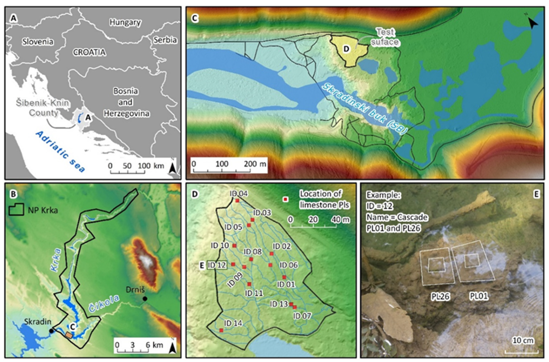
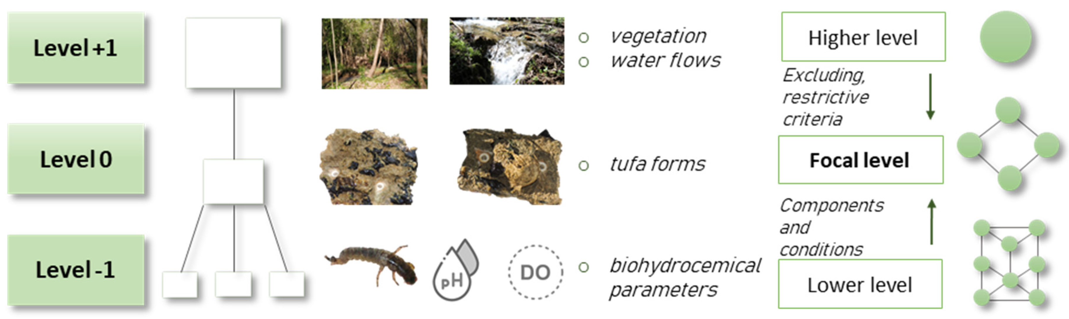
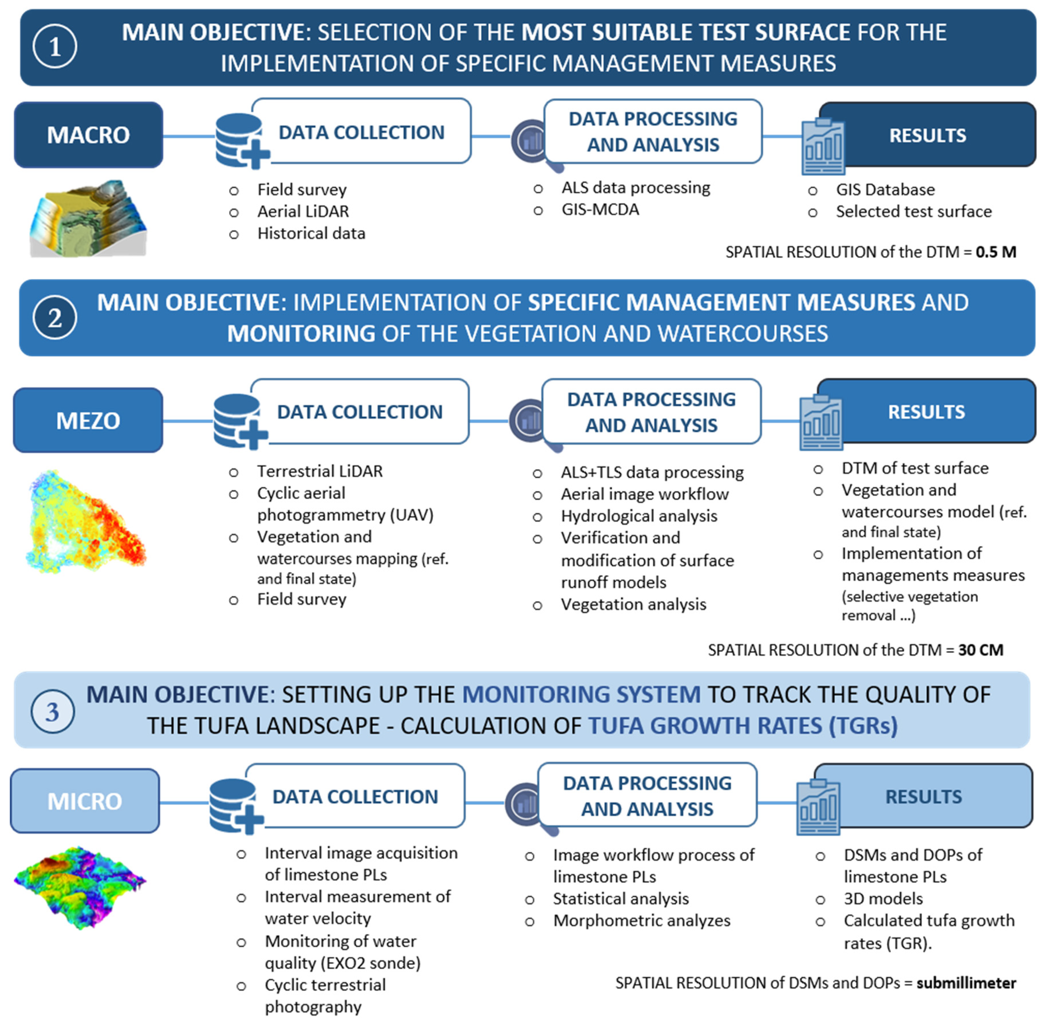
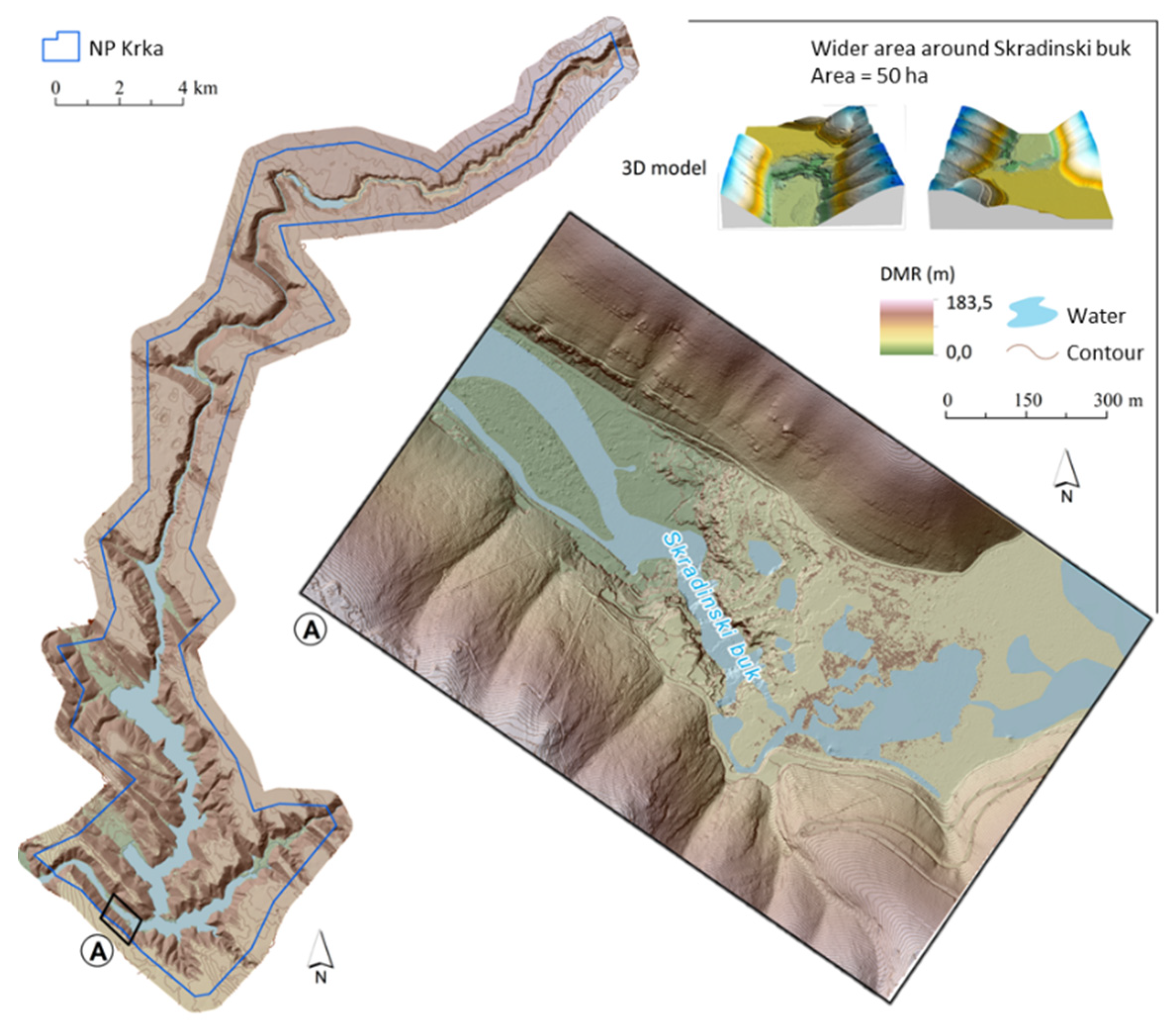
Case Study (Macro-Meso-Micro-Scale Research)
2. Materials and Methods
2.1. General Structure of the Methodological Framework
2.2. Macro-Scale Research
2.2.1. Field Surveys
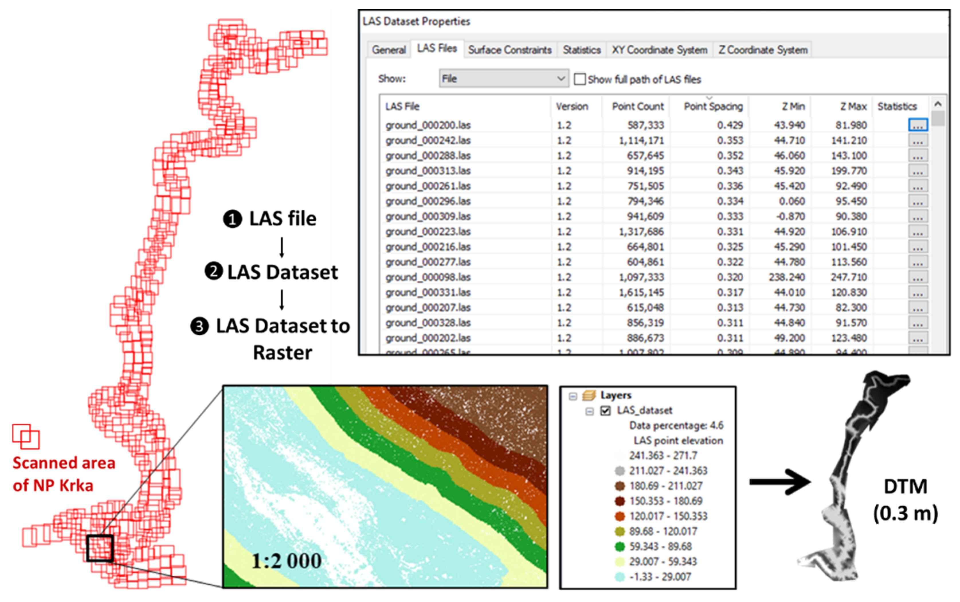
2.2.2. Aerial LiDAR Scanning
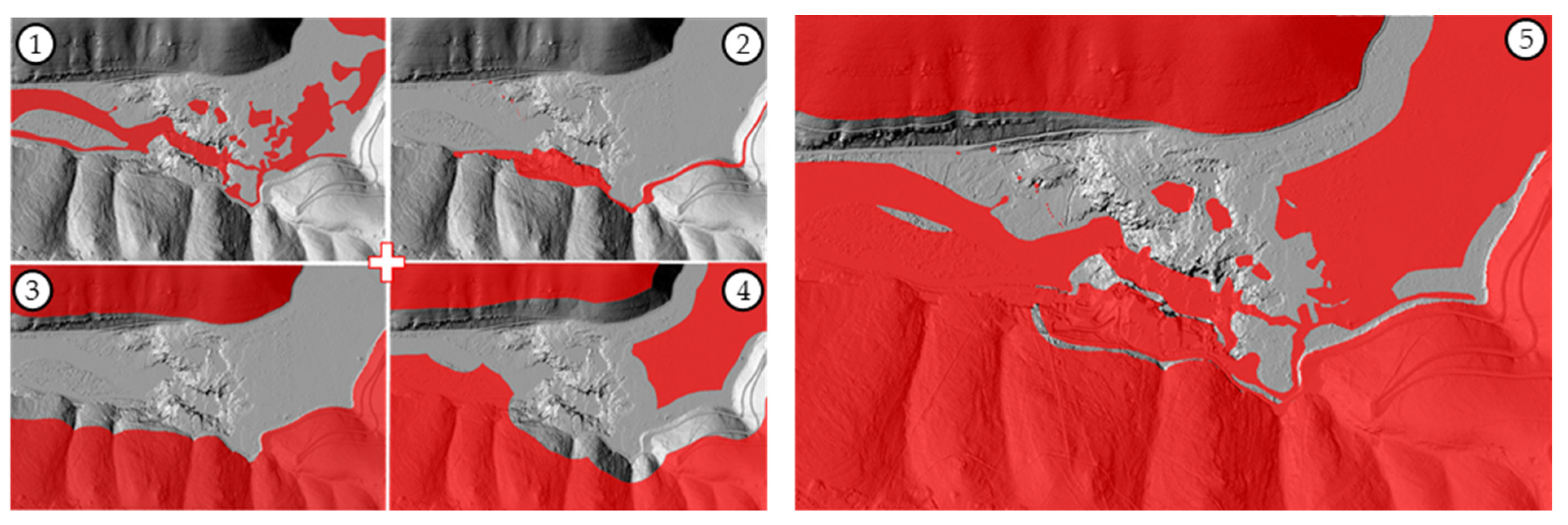
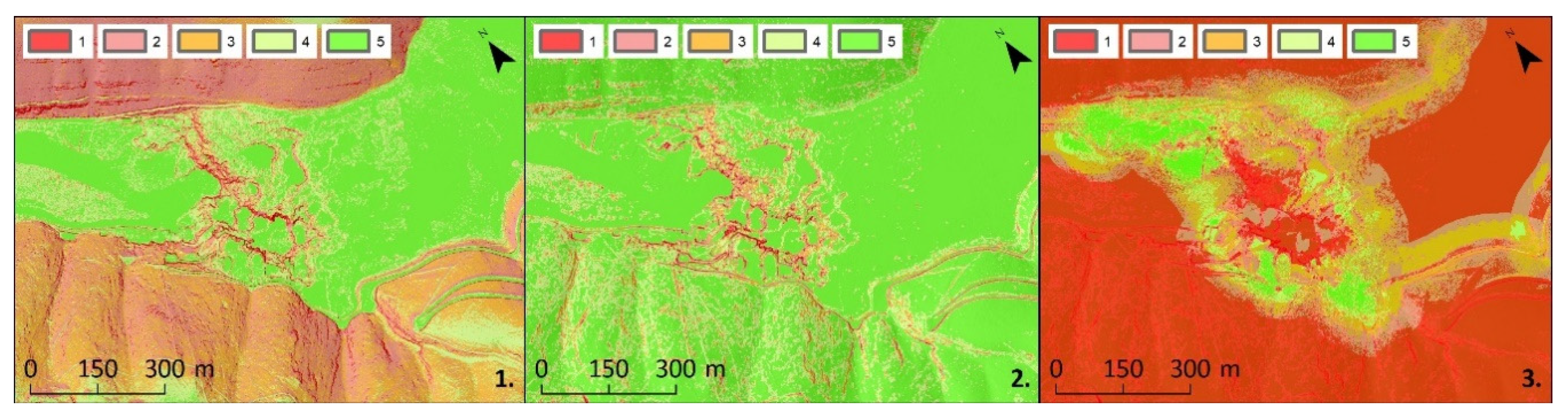
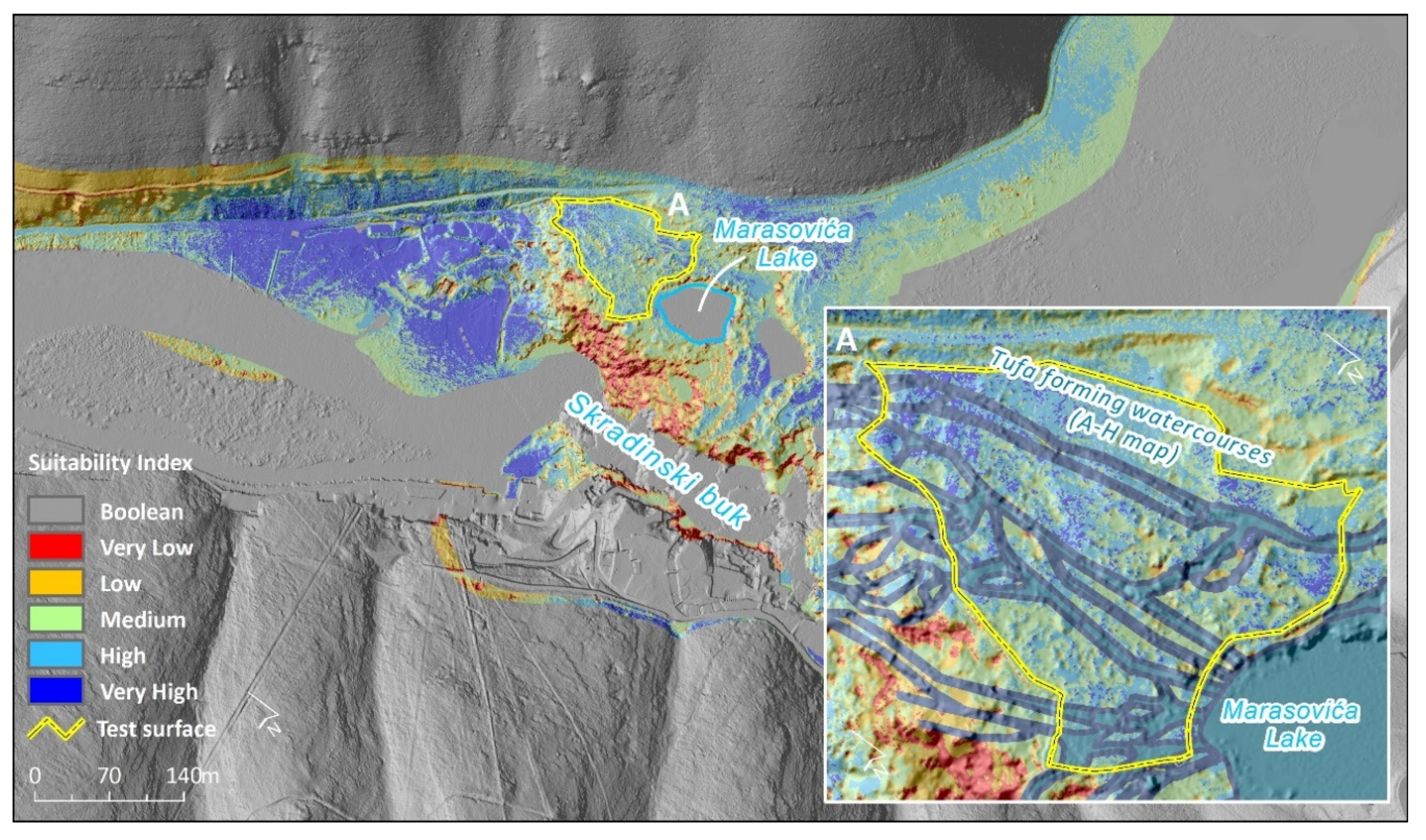
2.2.3. Application of GIS-MCDA in the Selection of the Test Surface
- Water surfaces;
- Built-up areas;
- Mountainous areas;
- Range of a terrestrial laser scanner (TLS) (Z + F Imager5600i)
- Terrain ruggedness;
- Slope;
- Viewshed/visibility
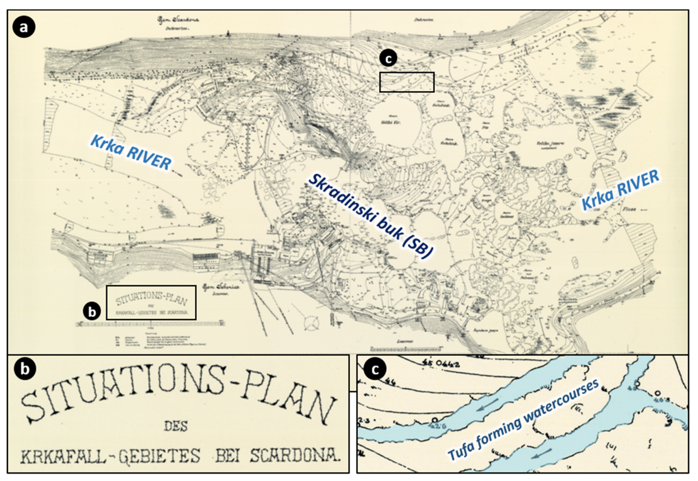
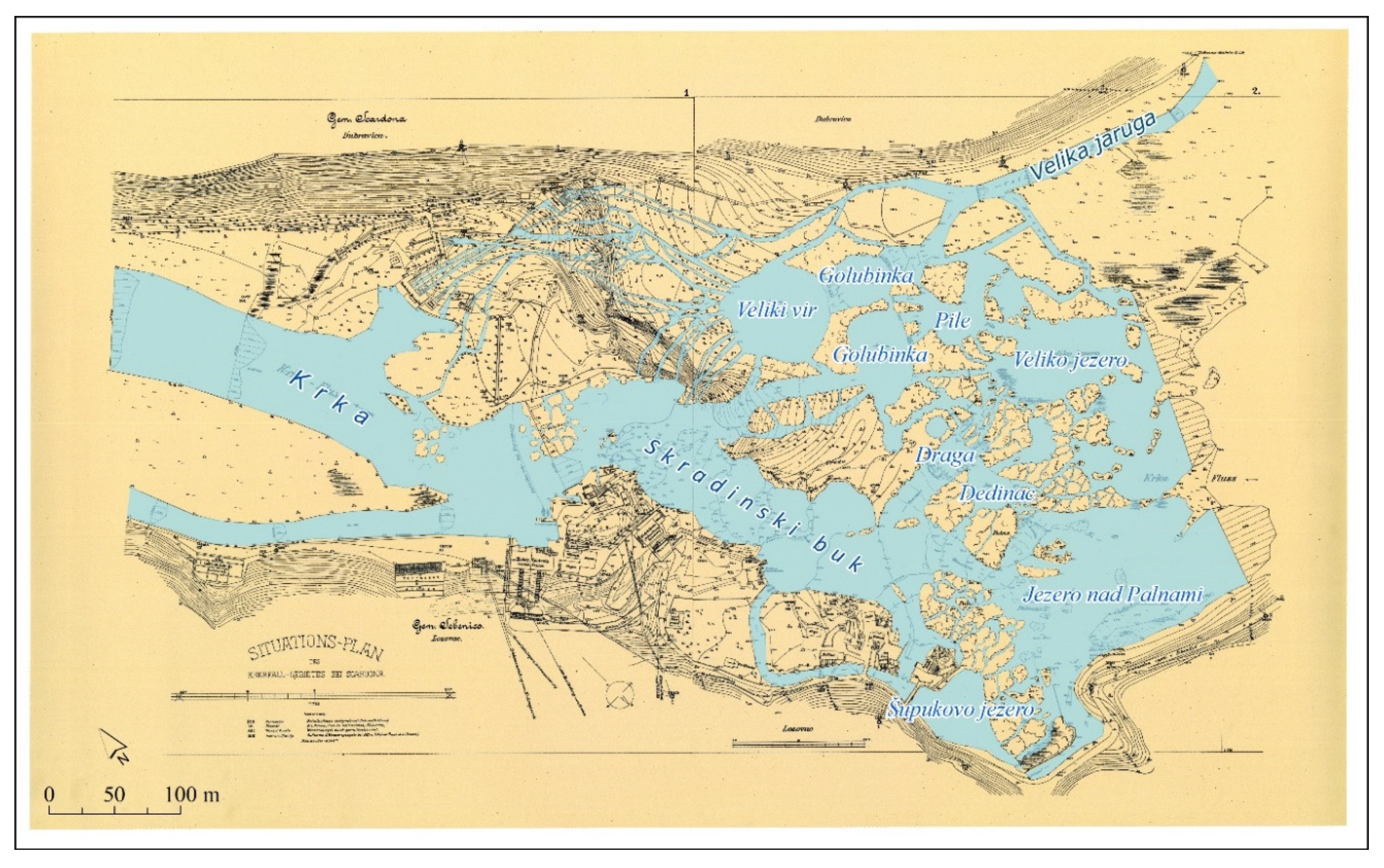
2.2.4. Historical Data (Austro-Hungarian Topographic Map)
2.3. Meso-Scale Research
- Mapping the referent state of vegetation and tufa-forming watercourses using terrestrial LiDAR scanning (Z + F Imager5600i), UAV photogrammetry (Phantom 4 Pro) and field survey (RTK-GPS Stonex S10).
- Manual and mechanical removal of invasive vegetation and implementation of management measures to mitigate the negative anthropogenic impact on the selected test surface.
- Mapping the final state of vegetation and reactivated tufa-forming watercourses using terrestrial LiDAR scanning (Faro FOCUS M70), UAV photogrammetry (Phantom 4 Pro) and field survey (RTK-GPS Stonex S10).
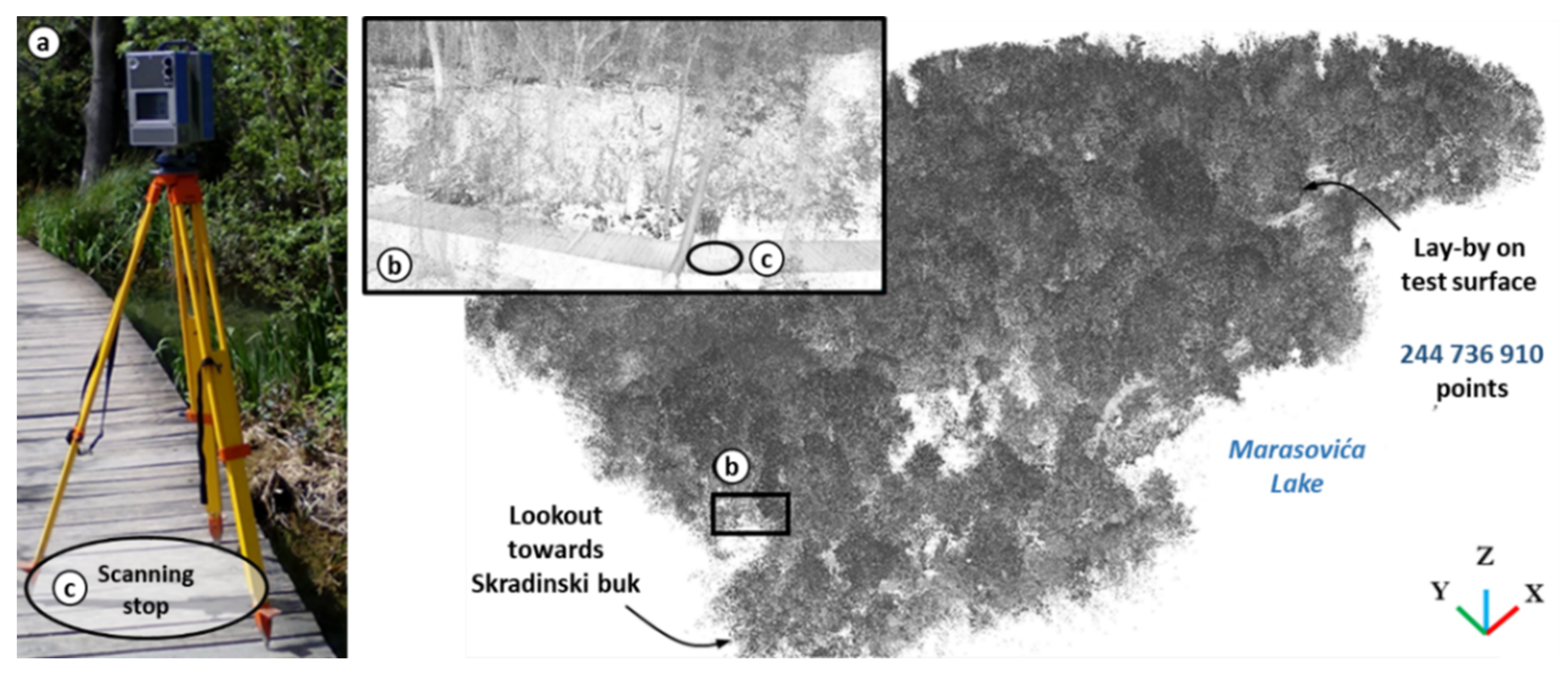
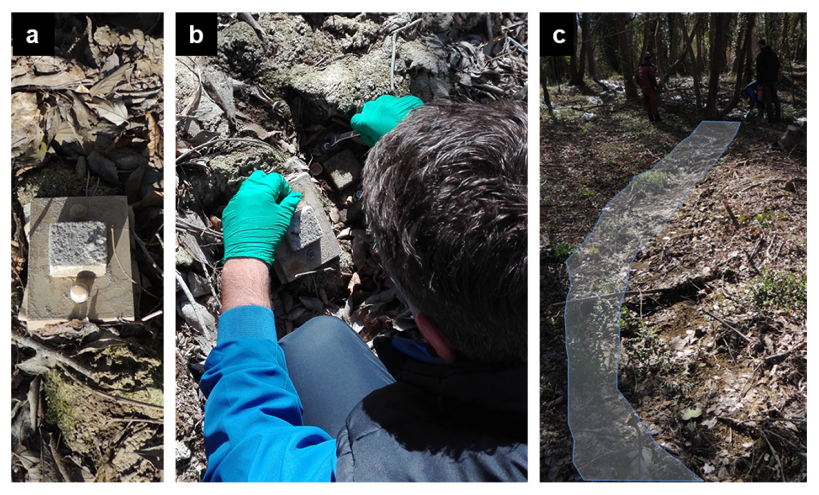
2.3.1. Terrestrial LiDAR Scanning
2.3.2. Cyclic UAV Photogrammetry
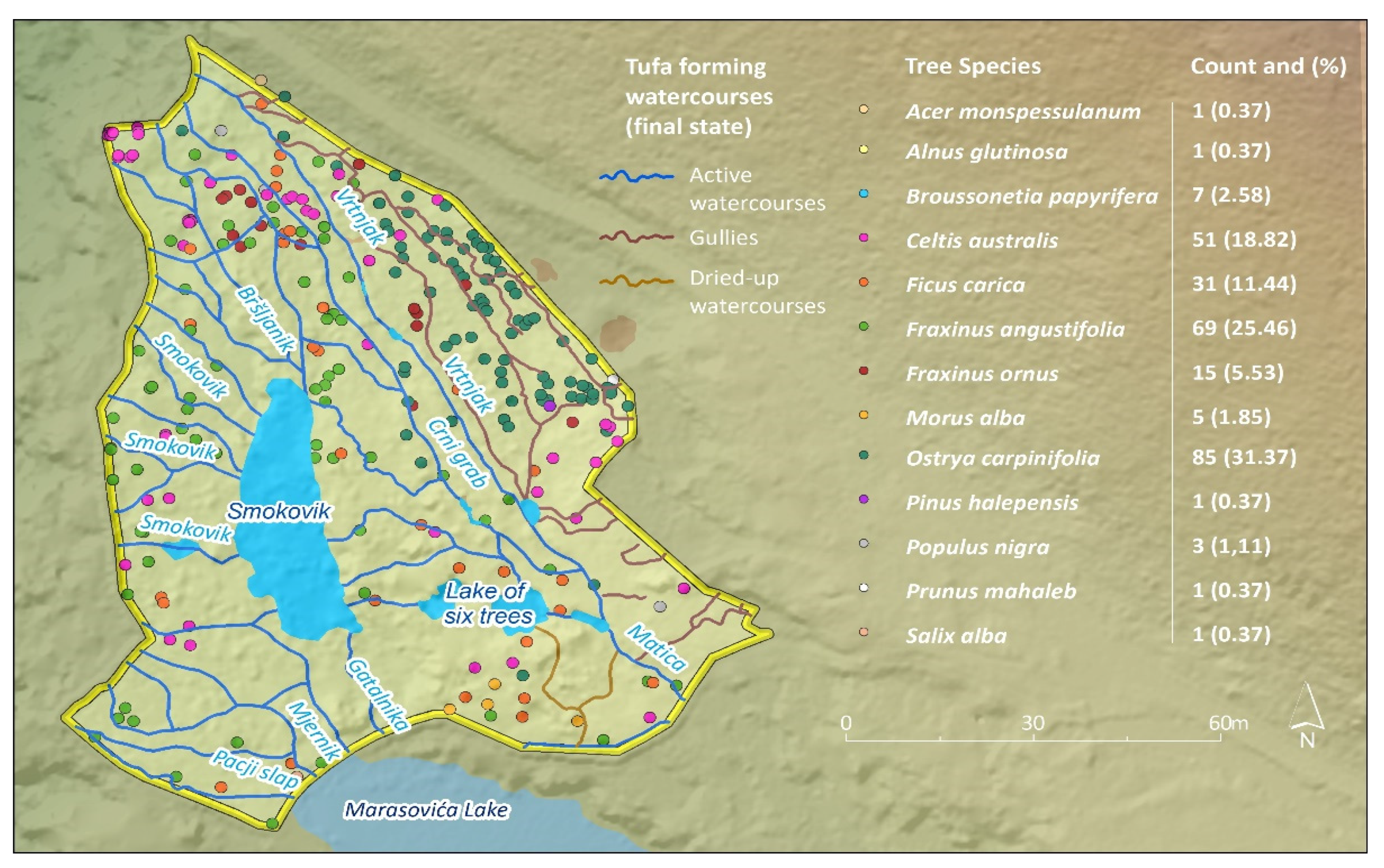
2.3.3. Mapping of Vegetation Cover and Tufa-Forming Watercourses
2.3.4. Development of a Plan for Invasive Vegetation Removal
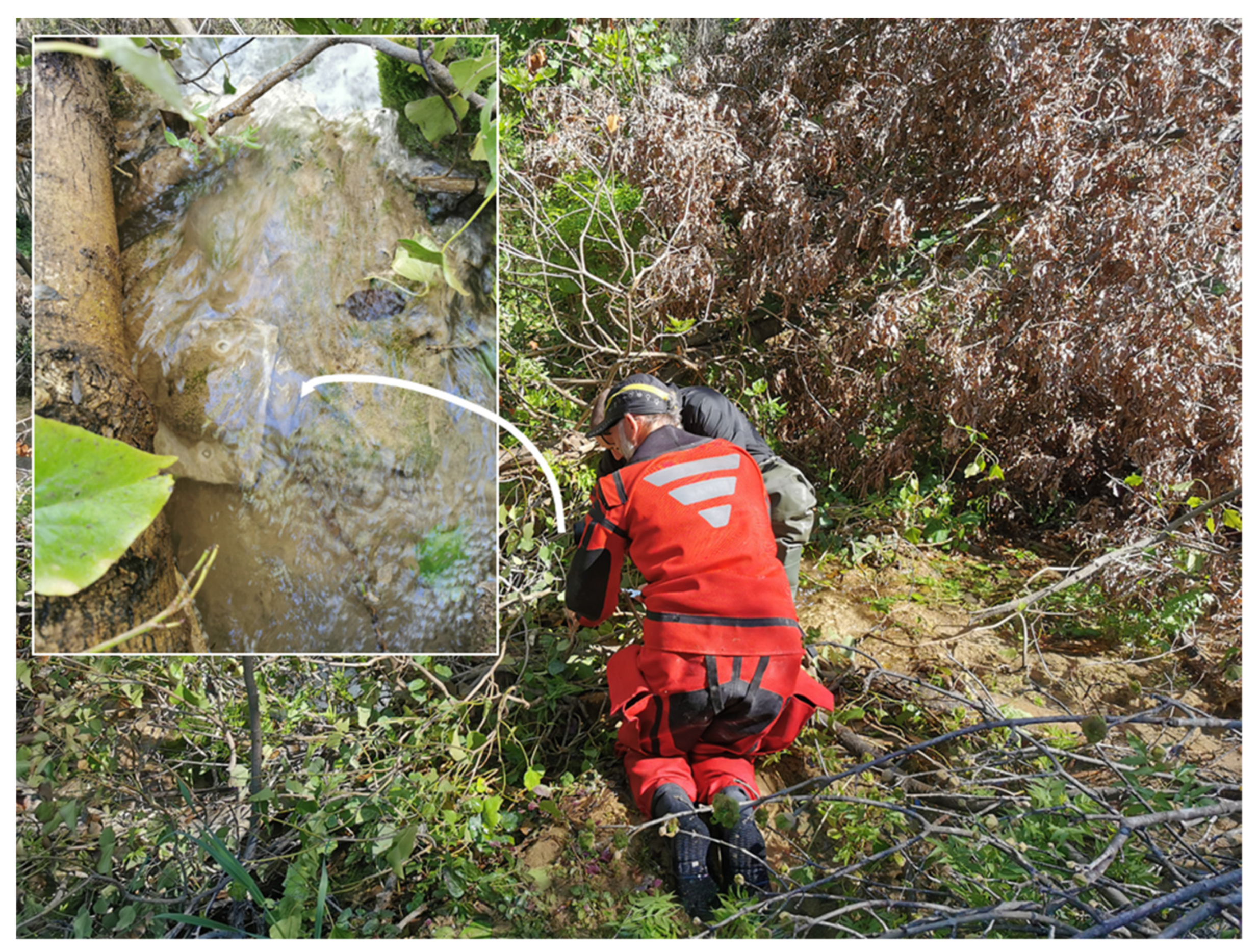
2.4. Micro-Scale Research
- Measurement of TFD on artificial PLs using structure from motion (SfM) photogrammetry (NIKON D5300 + macro lens LAOWA)
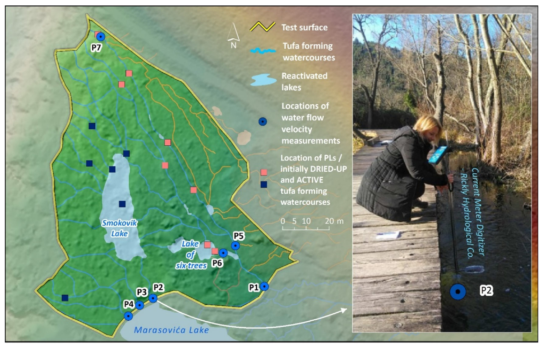
- Measurement of water flow velocity in reactivated tufa-forming watercourses (current meter digitizer, Rickly Hydrological Co., Columbus, OH, USA)
- Measurement of physico-chemical parameters in reactivated tufa-forming watercourses (YSI EXO2 multiparameter)
- Monitoring of invasive vegetation regeneration after manual and mechanical removal on the test surface (cyclic photography—interval camera).
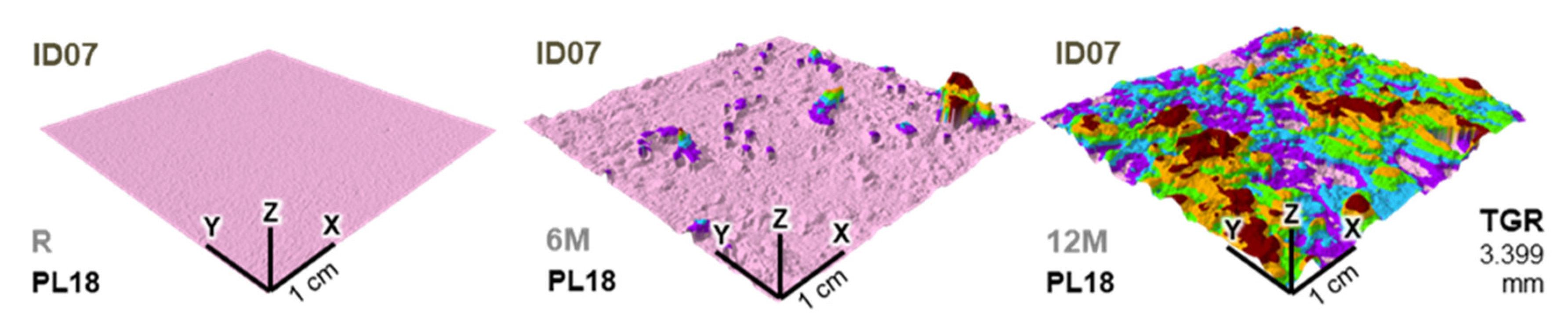
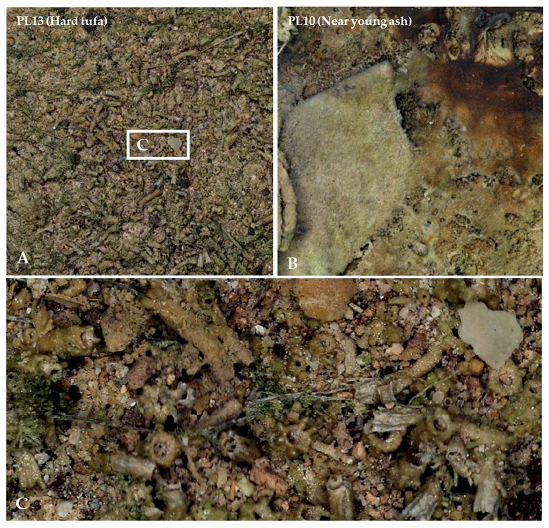
2.4.1. Measurement of TFD
2.4.2. Measurement of Water Flow Velocity
2.4.3. Measurement of Water Quality Using the YSI EXO2 Multiparameter Probe
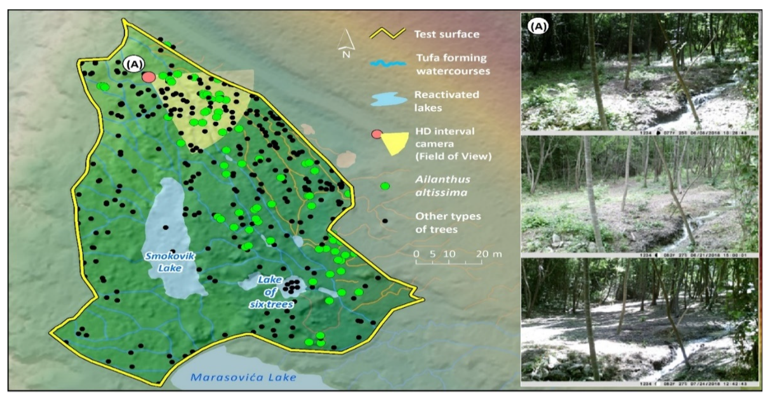
2.4.4. Monitoring of Invasive Vegetation Regeneration
3. Results
3.1. Macro-Scale of Research
3.1.1. Field Survey Results
3.1.2. Aerial LiDAR Scanning Results
3.1.3. Tufa-Forming Watercourses on the Austro-Hungarian Topographic Map
3.1.4. Selected Test Surface Using GIS-MCDA
3.2. Meso-Scale of Research
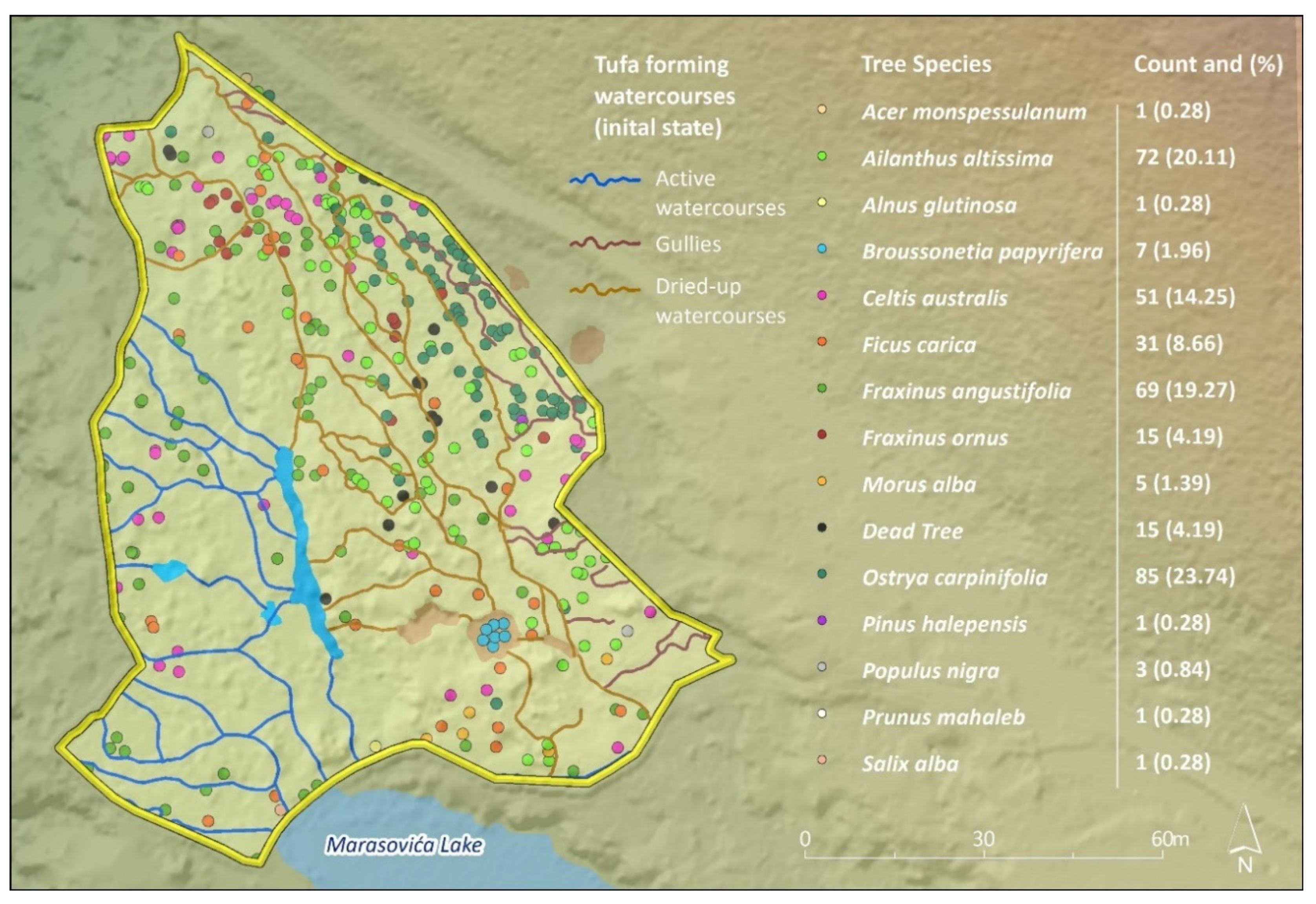
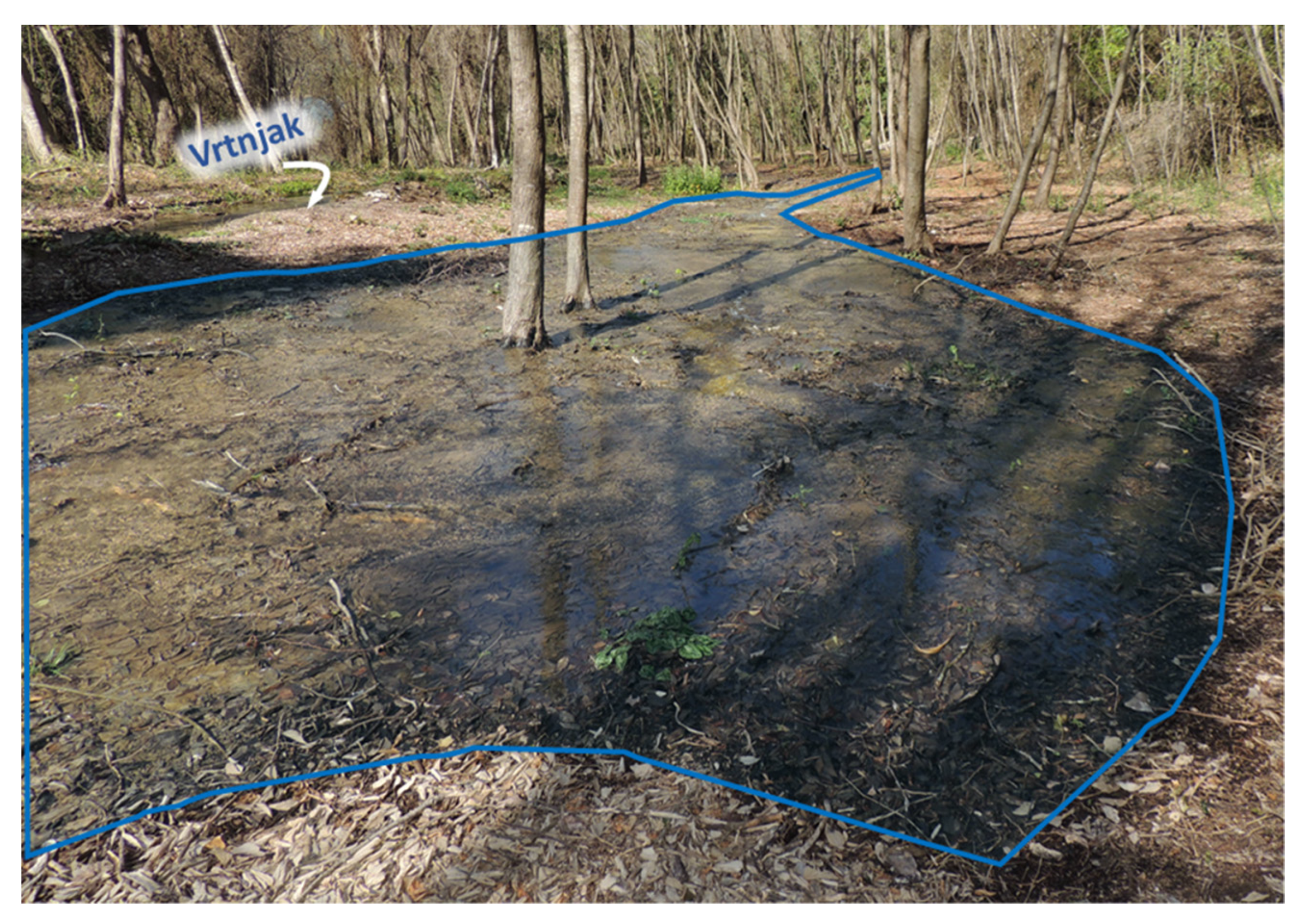
3.2.1. Initial State of Vegetation Cover and Tufa-Forming Watercourses
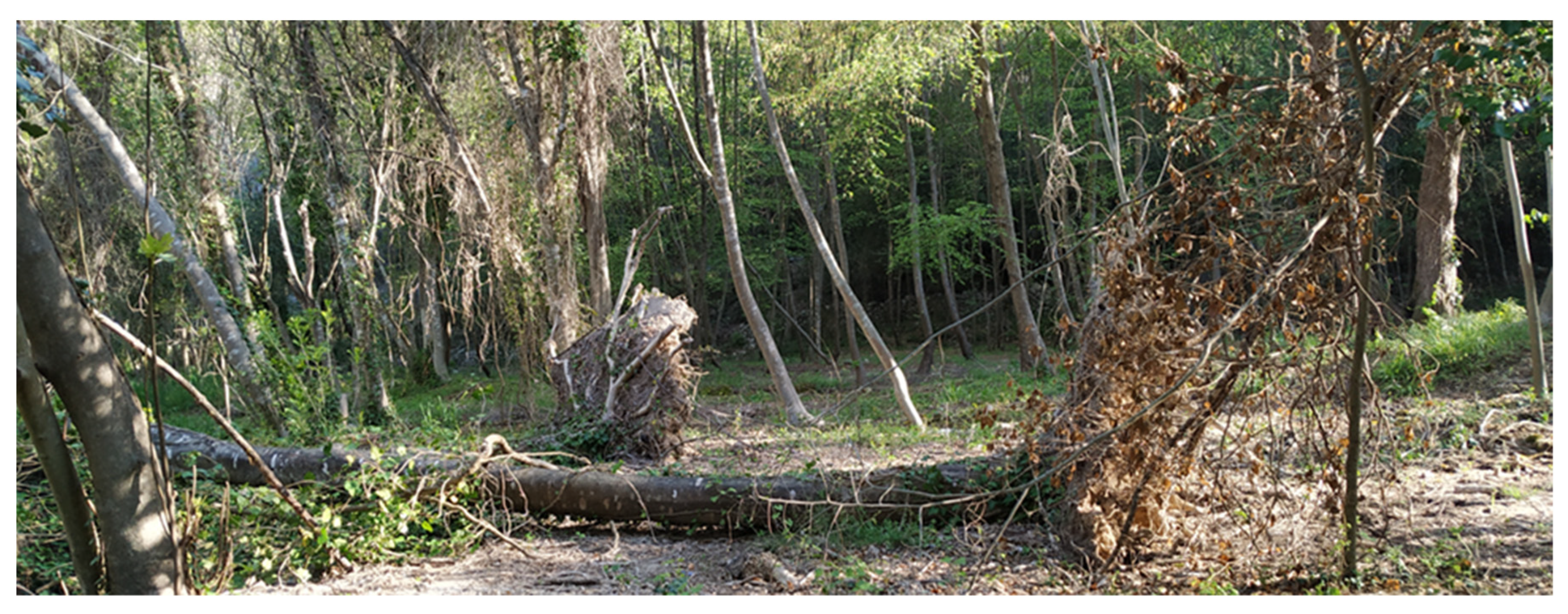
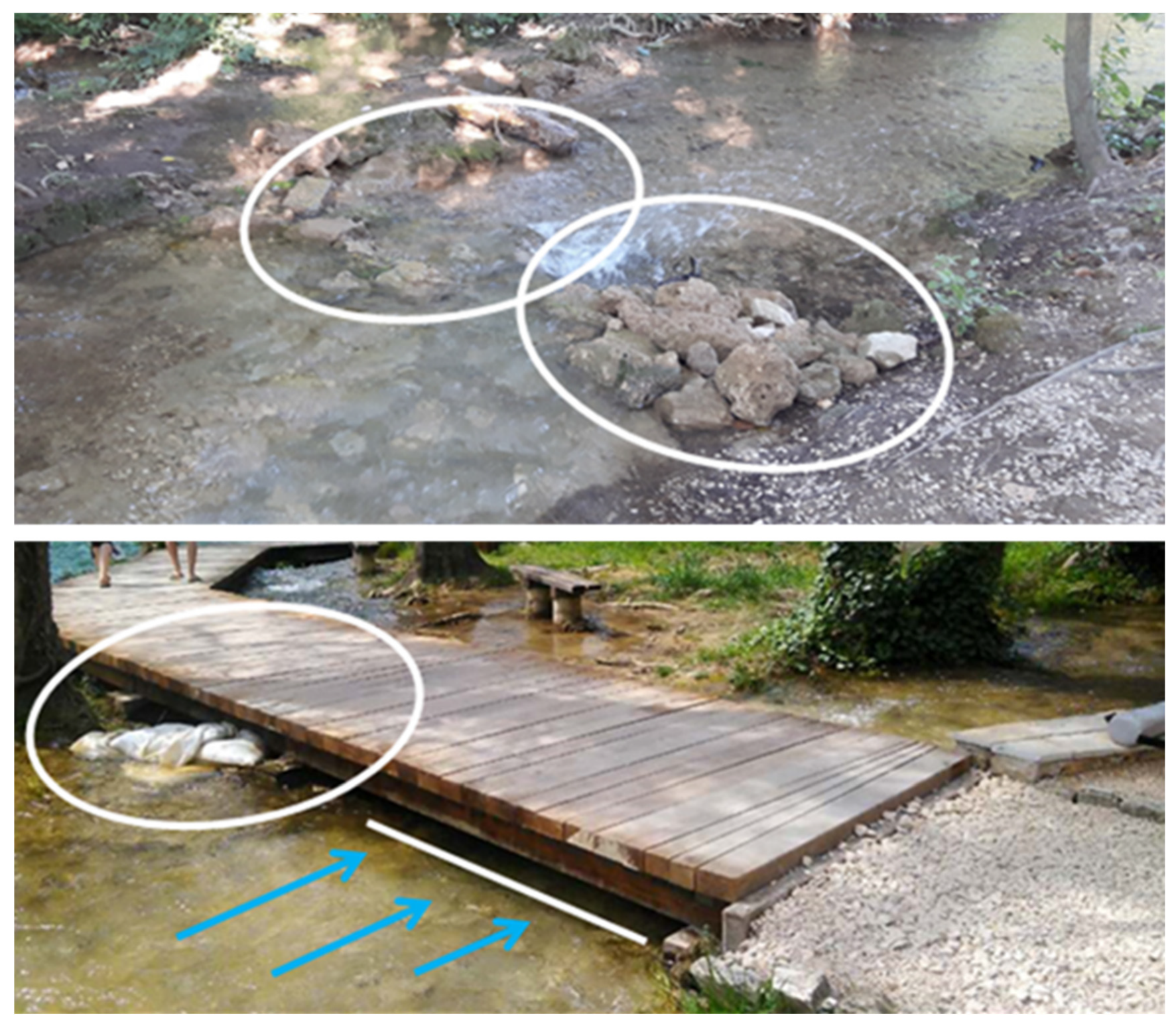
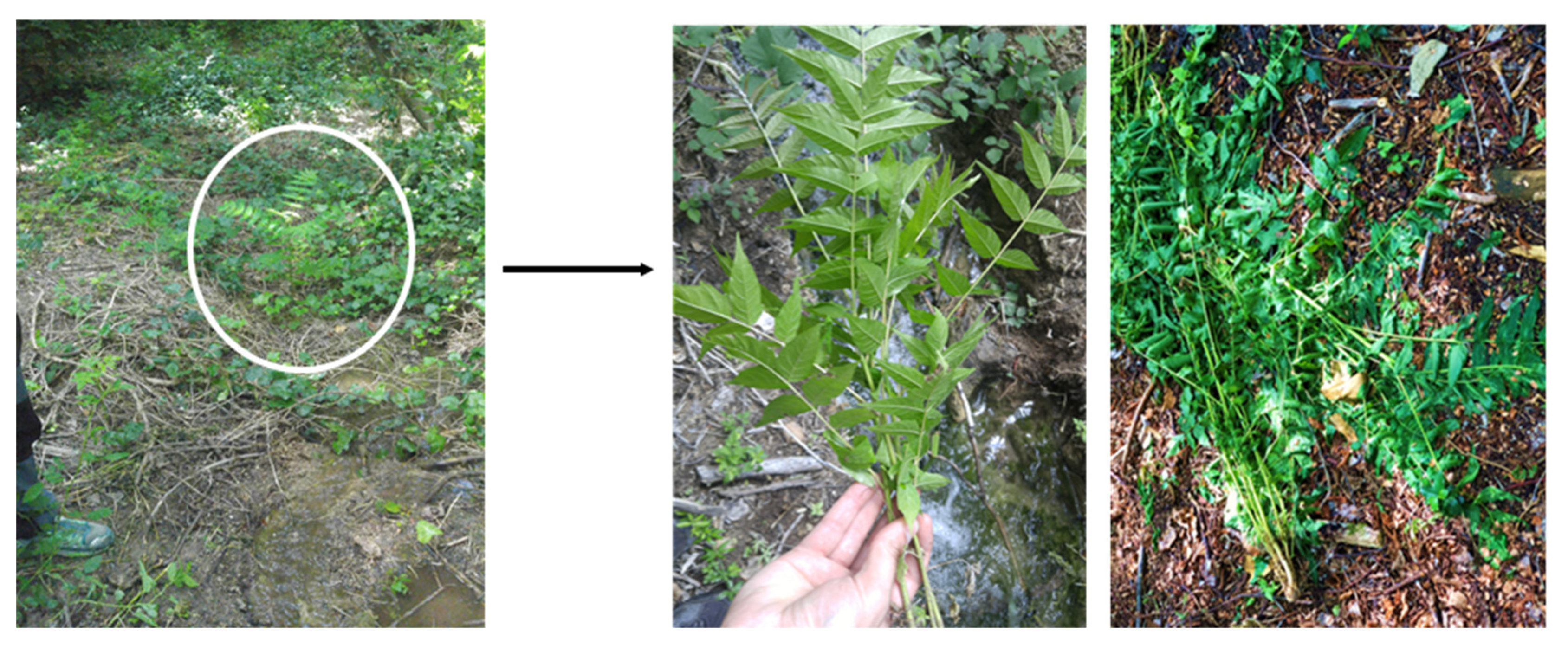
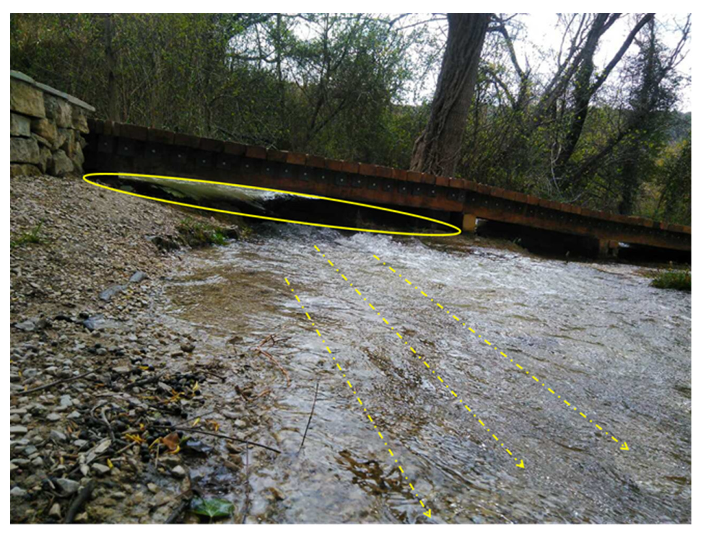
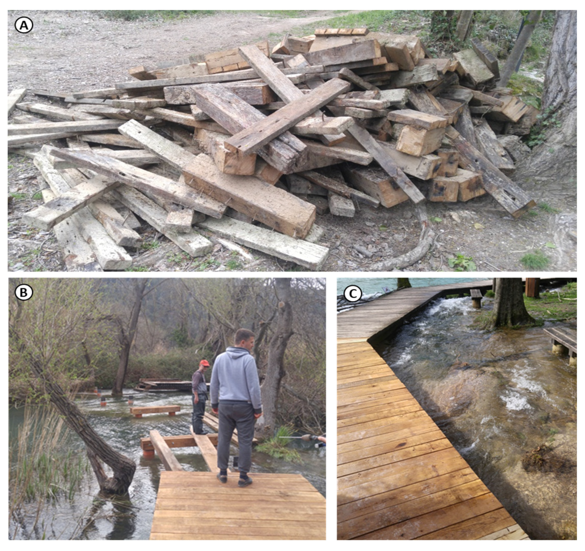
3.2.2. Removal of Invasive Vegetation and Mitigation of Anthropogenic Impact
- (1)
- Hand-picking (young seeds); (Figure 26)
- (2)
- Manual cutting or twitching (young trees up to 1–1.5 m high);
- (3)
- Manual cutting (trees that are not in the seed stage and mature trees that are inseminated)
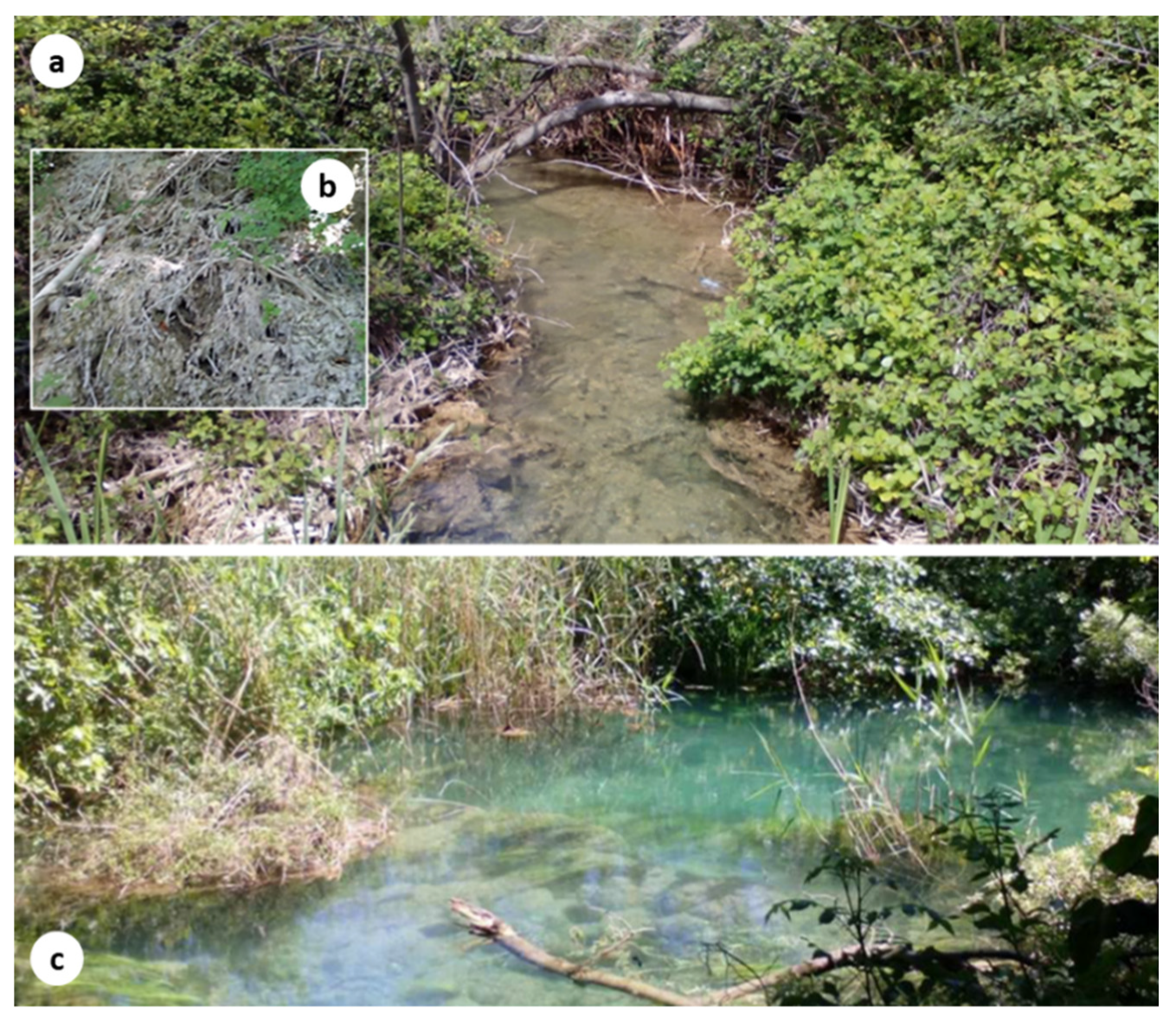
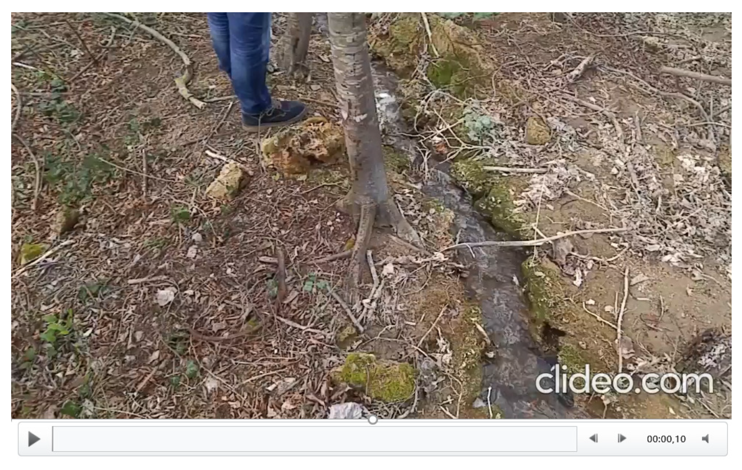
3.2.3. Final State of Vegetation Cover and Tufa-Forming Watercourses
3.3. Micro-Scale Research
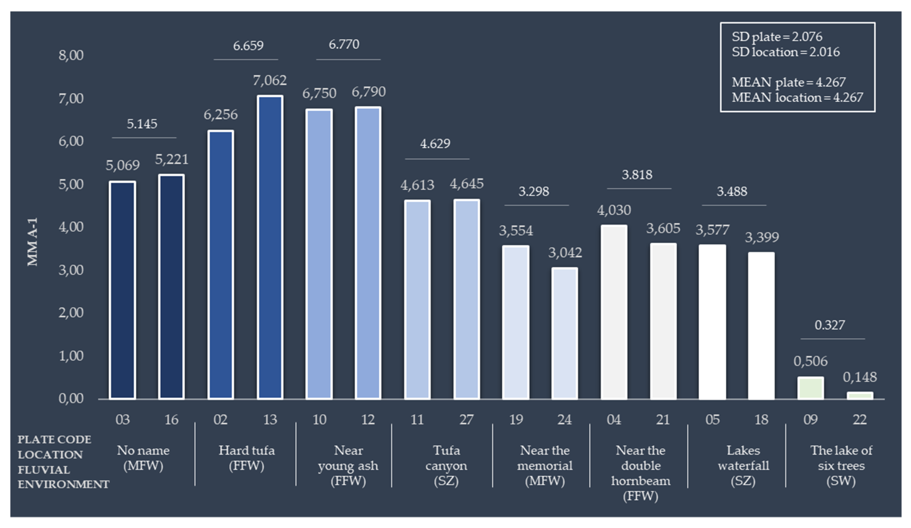
3.3.1. Tufa Growth in Reactivated Tufa-Forming Watercourses
3.3.2. Regeneration of Invasive Vegetation
3.3.3. Flow Velocity in Reactivated Tufa-Forming Watercourses
3.3.4. Physico-Chemical Characteristics of Tufa Forming Watercourses at Test Surface
4. Discussion
5. Conclusions
Supplementary Materials
Author Contributions
Funding
Acknowledgments
Conflicts of Interest
Abbreviations
| SB | Skradinski Buk |
| NP | National Park |
| HR | Croatia |
| IUCN | International Union for Conservation of Nature |
| DTM | Digital Terrain Model |
| AHP | Analytic Hierarchy Process |
| CR | Consistency Ratio |
| UAV | Unmanned Aerial Vehicle |
| TLS | Terrestrial Laser Scanning |
| IMU | Inertial Measurement Unit |
| TFD | Tufa Formation Dynamics |
| SfM | Structure from Motion |
| CMD | Coordinate Measuring Macro-photogrammetry Device |
| MEM | Modified Micro-Erosion Meter |
| TGR | Tufa Growth Rate |
| ODO | Optical Dissolved Oxygen |
| FNU | Formazin Nephelometric Units |
| RFU | Relative Fluorescence Unit |
| BGA-PC | Phycocyanin Blue-Green Algae Sensor |
| fDOM | Fluorescent Dissolved Organic Matter |
| QSU | Quinine Sulfate Unit |
References
- Blaschke, T.; Hay, G.J. Object-oriented image analysis and scale-space: Theory and methods for modeling and evaluating multiscale landscape structure. In Challenges in Geospatial Analysis, Integration and Visualization, Proceedings of the International Archives of Photogrammetry and Remote Sensing, Athens, GA, USA, 29–31 October 2001; International Society for Photogrammetry and Remote Sensing: Hannover, Germany, 2001; Volume 34, pp. 22–29. [Google Scholar]
- Šiljeg, A.; Lozić, S.; Marić, I. Quantitative analysis of the horizontal landscape structure of Vransko lake nature park. Ann. Anali Istrske Mediter. Studije Ser. Hist. Sociologia. 2017, 27, 563. [Google Scholar] [CrossRef]
- Van Beynen, P.; Townsend, K.A. Disturbance index for karst environments. Environ. Manag. 2005, 36, 101–116. [Google Scholar] [CrossRef] [PubMed]
- Brinkmann, R.; Parise, M. Karst environments: Problems, management, human impacts, and sustainability. An introduction to the special issue. J. Cave Karst. Stud. 2012, 74, 135–136. [Google Scholar] [CrossRef]
- Van Beynen, P.E. (Ed.) Introduction. In Karst Management; Springer Science & Business Media: Berlin, Germany, 2011; pp. 1–5. [Google Scholar]
- Qiao, X.; Du, J.; Lugli, S.; Ren, J.; Xiao, W.; Chen, P.; Tang, Y. Are climate warming and enhanced atmospheric deposition of sulfur and nitrogen threatening tufa landscapes in Jiuzhaigou National Nature Reserve, Sichuan, China? Sci. Total Environ. 2016, 562, 724–731. [Google Scholar] [CrossRef] [PubMed]
- Ford, T.D.; Pedley, H.M. A review of tufa and travertine deposits of the world. Earth Sci. Rev. 1996, 41, 117–175. [Google Scholar] [CrossRef]
- Frisia, S.; Borsato, A. Karst. In Developments in Sedimentology; Alonso-Zarza, A.M., Tanner, L.H., Eds.; Elsevier, B.V.: Amsterdam, The Netherlands, 2010; Volume 61, pp. 269–318. [Google Scholar]
- Cukrov, N.; Lojen, S. Tufa as environmental proxy in the karst river systems. In Proceedings of the 4th Croatian Geological Congress with International Participation, Zagreb, Croatia, 14–15 October 2010; Horvat, M., Ed.; Croatian Geological Survey: Zagreb, Croatia, 2010; pp. 312–313. [Google Scholar]
- Alexandrowicz, W.P. Protection of calcareous tufa sites in Southern Poland. Polish Geol. Inst. Spec. Pap. 2004, 13, 119–124. [Google Scholar]
- Carthew, K.D.; Taylor, M.P.; Drysdale, R.N. An environmental model of fluvial tufas in the monsoonal tropics, Barkly karst, northern Australia. Geomorphology 2006, 73, 78–100. [Google Scholar] [CrossRef]
- Viles, H.A.; Pentecost, A. Tufa and travertine. In Geochemical Sediments and Landscapes; Nash, D.J., McLaren, S.J., Eds.; Blackwell Publishing: Malden, MA, USA, 2007; pp. 173–199. [Google Scholar]
- Liu, L. Factors Affecting Tufa Degradation in Jiuzhaigou National Nature Reserve, Sichuan, China. Water 2017, 9, 702. [Google Scholar] [CrossRef]
- Scheuer, G.; Schweitzer, F. Genetics and occurrence of Holocene travertines in Hungary. In Geomorphological and Geoecological Essays; Pécsi, M., Ed.; Akademiai Kiado: Budapest, Hungary, 1989; pp. 39–48. [Google Scholar]
- Goudie, A.S.; Viles, H.A.; Pentecost, A. The late-Holocene tufa decline in Europe. Holocene 1993, 3, 181–186. [Google Scholar] [CrossRef]
- Gu, Y.; Du, J.; Tang, Y.; Qiao, X.; Bossard, C.; Deng, G. Challenges for sustainable tourism at the Jiuzhaigou World Natural Heritage site in western China. In Natural Resources Forum; John Wiley & Sons: Hoboken, NJ, USA, 2013; Volume 37, pp. 103–112. [Google Scholar]
- Zhou, X.L. Influences of geological environment deterioration on Jiuzhaigou ravine landscape. Carsologica Sin. 1998, 3, 119–128. [Google Scholar]
- Liu, Z.H.; Tian, Y.P.; An, D.J.; Wang, H.J.; Tang, S.; Zhang, J.L.; Sun, H.; Liu, Y.; Zhang, Q.M. Formation and evolution of the travertine landscape at Huanglong, Sichuan, one of the world natural heritages. Acta Geosci. Sin. 2009, 30, 841–847. [Google Scholar]
- Zhang, J.L.; Wang, H.J.; Li, D.; Zhao, D.M. An analysis of travertine landscape degradation in Huanglong Ravine of Sichuan, a world’s heritage site, and its causes and protection countermesures. Acta Ecol. Sin. 2012, 1, 111–120. [Google Scholar] [CrossRef]
- Guan, W.; Xie, C.; Ma, K.; Niu, J.; Zhao, Y.; Wang, X. A vital method fro constructing regional ecological security patern; landscape ecolgical restoration and rehabilitation. Acta Ecol. Sin. 2003, 23, 64–73. [Google Scholar]
- Pribičević, B.; Medak, D.; Đapo, A. Integracija suvremenih geodetsko-hidrografskih mjernih metoda u krškim područjima Republike Hrvatske. Ekscentar 2010, 12, 58–63. [Google Scholar]
- Horvatinčić, N.; Briansó, J.L.; Obelić, B.; Barešić, J.; Bronić, I.K. Study of pollution of the Plitvice Lakes by water and sediment analyses. In The Interactions between Sediments and Water; Kronvang, B., Faganeli, J., Ogrinc, N., Eds.; Springer Netherlands: Dordrecht, The Netherlands, 2006; pp. 111–121. [Google Scholar]
- IUCN. Land Degradation Neutrality: Implications and Opportunities for Conservation Nature Based Solutions to Desertification, Land Degradation and Drought, 2nd ed.; IUCN: Gland, Switzerland; Available online: https://portals.iucn.org/library/node/47869 (accessed on 1 March 2020).
- Pekčec, S. Geokemijske Osnove Nastanka Sedre. Bachelor’s Thesis, University of Zagreb, Zagreb, Croatia, 14 July 2017. [Google Scholar]
- Gulin, V.; Kepčija, R.M.; Perić, M.S. Spatio-temporal patterns of tufa deposition and periphyton community dynamics along the newly formed water pathways in National Park Krka, Croatia. In Proceedings of the 13th Hrvatski Biološki Kongres s Međunarodnim Sudjelovanjem, Poreč, Croatia, 19–23 September 2018; pp. 67–68. [Google Scholar]
- Darwall, W.; Carrizo, S.; Numa, C.; Barrios, V.; Freyhof, J.; Smith, K. Freshwater Key Biodiversity Areas in the Mediterranean Basin Hotspot: Informing Species Conservation and Development Planning in Freshwater Ecosystems; IUCN: Gland, Switzerland, 2014. [Google Scholar]
- Terzić, S.; Mikac, N.; Dautović, J.; Ahel, M. Anthropogenic contaminants in water and sediments of the Plitvice Lakes-implications for environmental protection and water management. In Proceedings of the Second International Conference on Waters in Protected Areas, Dubrovnik, Croatia, 24–28 April 2007; Nakić, Z., Ed.; Croatian Water Pollution Control Society: Zagreb, Croatia, 2007; pp. 196–199. [Google Scholar]
- Meaški, H.; Biondić, R.; Biondić, B. The conceptual hydrogeological model of the Plitvice Lakes. Geol. Croat. 2010, 63, 195–206. [Google Scholar]
- Vurnek, M.; Brozinčević, A.; Čulinović, K.; Novosel, A. Challenges in the Management of Plitvice Lakes National Park, Republic of Croatia. National Parks-Management and Conservation. In National Parks—Management and Conservation; Suratman, M.N., Ed.; IntechOpen: London, UK, 2018. [Google Scholar]
- Knjaz, H. Plitvička Jezera-Biser pod Povećalom UNESCO-a. Bachelor’s Thesis, University of Zagreb, Zagreb, Croatia, 20 September 2019. [Google Scholar]
- Total-Croatia_News. Available online: https://www.total-croatia-news.com/item/14741-ministry-denies-plitvice-lakes-will-lose-unesco-world-heritage-status (accessed on 1 March 2020).
- BalkanInsight. Available online: https://balkaninsight.com/2017/04/17/uncontrolled-tourism-threatens-balkan-unesco-sites-04-13-2017/ (accessed on 2 March 2020).
- Bulat, Ž. Institucionalni okvir zaštite prirode u Republici Hrvatskoj. Pravni Vjesnik: Časopis za Pravne i Društvene Znanosti Pravnog Fakulteta Sveučilišta JJ Strossmayera u Osijeku 2012, 28, 95–128. [Google Scholar]
- Ministry of Tourism. Available online: https://www.htz.hr/sites/default/files/2017-06/Tourism_in_figures_ENG_2016.pdf (accessed on 10 January 2020).
- Rubinić, J.; Goreta, G.; Giljušić, M.; Marguš, D.; Radišić, M.; Zwicker Kompar, G.; Kompar, D. Hidrologija Krke—utjecaji i promjene. In Zbornik Radova: Vizija i Izazovi Upravljanja Zaštićenim Područjima Prirode u Republici Hrvatskoj; Marguš, D., Ed.; Javna ustanova “Nacionalni park Krka”: Šibenik, Croatia, 2017; pp. 705–720. [Google Scholar]
- Bonacci, O.; Andrić, I.; Roje-Bonacci, T. Hydrological analysis of Skradinski Buk tufa waterfall (Krka River, Dinaric karst, Croatia). Environ. Earth Sci. 2017, 76, 669. [Google Scholar] [CrossRef]
- Brajković, I. Primjena Rezultata Ankete Posjetitelja u Javnoj Ustanovi Nacionalni Park Krka. Bachelor’s Thesis, Polytechnic in Šibenik, Šibenik, Croatia, 14 July 2016. [Google Scholar]
- Prohić, E.; Juračić, M. Heavy metals in sediments—Problems concerning determination of the anthropogenic influence. Study in the Krka River estuary, eastern Adriatic coast, Yugoslavia. Environ. Geol. Water Sci. 1989, 13, 145–151. [Google Scholar] [CrossRef]
- Srdoč, D.; Horvatinčić, N.; Ahel, M.; Giger, W.; Schaffner, C.; Bronić, I.K.; Petricioli, D.; Pezdič, J.; Marčenko, E.; Plenković-Moraj, A. Anthropogenic influence on the 14 C activity and other constituents of recent lake sediments: A case study. Radiocarbon 1992, 34, 585–592. [Google Scholar]
- Mikac, I.; Fiket, Ž.; Terzić, S.; Barešić, J.; Mikac, N.; Ahel, M. Chemical indicators of anthropogenic impacts in sediments of the pristine karst lakes. Chemosphere 2011, 84, 1140–1149. [Google Scholar] [CrossRef]
- Marguš, D. Nacionalni Park Krka—Plan Upravljanja; Javna ustanova “Nacionalni park Krka”: Šibenik, Croatia, 2011. [Google Scholar]
- Medunić, G.; Cindrić, I.J.; Pivčević, N.; Kampić, Š.; Prohić, E.; Goreta, G.; Čobić, A. Chemical and textural composition of the Krka River tufa deposits from the Dinaric Karst region of Croatia. In Proceedings of thr Protected Karst Territories-Monitoring and Management, Shumen, Bulgaria, 16–20 September 2012; Stefanov, P., Yordanova, M., Stefanova, D., Mihova, D., Eds.; proKARSTerra: Sofia, Bulgaria, 2012; pp. 128–137. [Google Scholar]
- Wu, J. Hierarchy and scaling: Extrapolating information along a scaling ladder. Can. J. Remote Sens. 1999, 25, 367–380. [Google Scholar] [CrossRef]
- Levin, S.A. The problem of pattern and scale in ecology: The Robert, H. MacArthur award lecture. Ecology 1992, 73, 1943–1967. [Google Scholar] [CrossRef]
- Manzo, E.; Perri, E.; Tucker, M.E. Carbonate deposition in a fluvial tufa system: Processes and products (Corvino Valley–southern Italy). Sedimentology 2012, 59, 553–577. [Google Scholar] [CrossRef]
- Malczewski, J. GIS-based multicriteria decision analysis: A survey of the literature. Int. J. Geogr. Inf. Sci. 2006, 20, 703–726. [Google Scholar] [CrossRef]
- Domazetović, F.; Šiljeg, A.; Lončar, N.; Marić, I. Development of automated multicriteria GIS analysis of gully erosion susceptibility. Appl. Geogr. 2019, 112, 102083. [Google Scholar] [CrossRef]
- Malczewski, J.; Rinner, C. Multicriteria Decision Analysis in Geographic Information Science; Springer: New York, NY, USA, 2015; pp. 220–228. [Google Scholar]
- Slukan Altić, M. Instrukcija za arhivare mapa-prva arhivistička uputa za specijalizirane arhive. Vjesnik Istarskog Arhiva 2007, 8, 81–103. [Google Scholar]
- Van Wilgen, B.W.; Cowling, R.M.; Marais, C.; Esler, K.J.; McConnachie, M.; Sharp, D. Challenges in invasive alien plant control in South Africa. South Afr. J. Sci. 2012, 108, 11–12. [Google Scholar] [CrossRef][Green Version]
- Foxcroft, L.C.; Richardson, D.M.; Wilson, J.R. Ornamental plants as invasive aliens: Problems and solutions in Kruger National Park, South Africa. Environ. Manag. 2008, 41, 32–51. [Google Scholar] [CrossRef]
- Cowie, I.D.; Werner, P.A. Alien plant species invasive in Kakadu National Park, tropical northern Australia. Biol. Conserv. 1993, 63, 127–135. [Google Scholar] [CrossRef]
- Constán-Nava, S.; Bonet, A.; Pastor, E.; Lledó, M.J. Long-term control of the invasive tree Ailanthus altissima: Insights from Mediterranean protected forests. For. Ecol. Manag. 2010, 260, 1058–1064. [Google Scholar] [CrossRef]
- Fire Effects Information System (FEIS). Available online: https://www.fs.fed.us/database/feis/plants/tree/ailalt/all.html (accessed on 10 April 2020).
- Ecolandscaping. Available online: https://www.ecolandscaping.org/05/landscape-challenges/invasive-plants/tree-of-heaven-an-exotic-invasive-plant-fact-sheet/ (accessed on 14 April 2020).
- Marić, I.; Šiljeg, A.; Cukrov, N.; Roland, V.; Domazetović, F. How fast does tufa grow? Very high-resolution measurement of the tufa growth rate on artificial substrates by the development of a contactless image-based modelling device. Earth Surf. Process. Landf. 2020, 40, 2331–2349. [Google Scholar] [CrossRef]
- Novak, N.; Kravarščan, M. Pajasen (Ailanthus altissima (Mill.) Swingle)-strana invazivna biljna vrsta u hrvatskoj. Glasilo Biljne Zaštite 2014, 14, 254–261. [Google Scholar]
- Lodeta, V.; Novak, N.; Kravarščan, M. Tree of heaven (Ailanthus altissima (Mill.) Swingle)—Colonization in Croatia. In Proceedings of the 2nd International Workshop on Invasive Alien Plants in Mediterranean Type Regions of the World Proceedings, Trabzon, Turkey, 2–6 August, 2010; Brunel, S., Uludag, A., Fernandez-Galiano, E., Brundu, G., Eds.; European Environment Agency: Copenhagen, Denmark, 2010; pp. 350–352. [Google Scholar]
- Wetzel, R.G. Limnology, 2nd ed.; Saunders College Publishing: Philadelphia, PA, USA, 1983; p. 760. [Google Scholar]
- Krivograd Klemenčič, A.; Vrhovšek, D.; Kosi, G. Alge na sedrenim barijerama rijeke Krke kod Žužemberka, Slovenija. Nat. Croat. Period. Musei Historiae Nat. Croat. 2004, 13, 371–379. [Google Scholar]
- Špoljar, M.; Štafa, D.; Ostojić, A.; Dražina, T.; Matoničkin Kepčija, R.; Kralj Borojević, K.; Primc, B. Tufa deposition in a karst stream as an indicator of water quality (Papuk Nature Park, Croatia). Croat. J. Fish. Ribar. 2011, 69, 137–151. [Google Scholar]
- Cukrov, N.; Cmuk, P.; Mlakar, M.; Omanović, D. Spatial distribution of trace metals in the Krka River, Croatia: An example of the self-purification. Chemosphere 2008, 72, 1559–1566. [Google Scholar] [CrossRef]
- Belančić, A.; Kepčija, R.M.; Miliša, M.; Moraj, A.P.; Habdija, I. Flow velocity effect on leaf litter breakdown in tufa depositing system (Plitvice Lakes, Croatia). Int. Rev. Hydrobiol. 2009, 94, 391–398. [Google Scholar] [CrossRef]
- Arenas, C.; Osácar, C.; Sancho, C.; Vázquez-Urbez, M.; Auqué, L.; Pardo, G. Seasonal record from recent fluvial tufa deposits (Monasterio de Piedra, NE Spain): Sedimentological and stable isotope data. Geol. Soc. Lond. Spec. Publ. 2010, 336, 119–142. [Google Scholar] [CrossRef]
- Auqué, L.F.; Arenas, C.; Osácar, C.; Pardo, G.; Sancho, C.; Vázquez-Urbez, M. Tufa sedimentation in changing hydrological conditions: The River Mesa (Spain). Geol. Acta 2013, 11, 85–102. [Google Scholar] [CrossRef]
- Fondriest Environmental, Inc. “pH of Water.” Fundamentals of Environmental Measurements. Available online: https://www.fondriest.com/environmental-measurements/parameters/water-quality/ph/ (accessed on 19 November 2019).
- Adamec, L.; Ondok, J.P. Water alkalization due to photosynthesis of aquatic plants: The dependence on total alkalinity. Aquat. Bot. 1992, 43, 93–98. [Google Scholar] [CrossRef]
- Horne, A.J.; Goldman, C.R. Limnology; McGraw-Hill: New York, NY, USA, 1994; Volume 2. [Google Scholar]
- Rebbeck, J.; Jolliff, J. How long do seeds of the invasive tree, Ailanthus altissima remain viable? For. Ecol. Manag. 2018, 429, 175–179. [Google Scholar] [CrossRef]
- Srdoč, D.; Obelić, B.; Horvatinčić, N.; Culiberg, M.; Šercelj, A.; Sliepčević, A. Radiocarbon dating and pollen analyses of two peat bogs in the Plitvice National Park. Acta Bot. Croat. 1985, 44, 41–46. [Google Scholar]
- Matoničkin, I.; Pavletić, Z. Biološke karakteristike sedrenih slapova u našim krškim rijekama. Hrvatski Geogr. Glas. 1960, 22, 43–55. [Google Scholar]
- Weijermars, R.; Mulder-Blanken, C.W.; Wiegers, J. Growth rate observation from the moss-built Checa travertine terrace, central Spain. Geol. Mag. 1986, 123, 279–286. [Google Scholar] [CrossRef]
- Gulin, V.; Matoničkin Kepčija, R.; Sertić Perić, M. Reactivated Channels Along Tufa Barrier as Favorable Habitat for Colonization of Microfauna. In Proceedings of the VIII European Congress of Protistology (ECOP)—ISOP Joint Meeting, Rome, Italy, 28 June–2 August 2019; p. 120. [Google Scholar]


| Criteria | Viewshed Analysis | Terrain Ruggedness | Slope | Total | Weight Coefficients | Consistency Measure |
|---|---|---|---|---|---|---|
| Viewshed Analysis | 0.546 | 0.570 | 0.500 | 1.617 | 0.539 | 3.014 |
| Terrain Ruggedness | 0.273 | 0.290 | 0.330 | 0.892 | 0.297 | 3.008 |
| Slope | 0.182 | 0.140 | 0.170 | 0.491 | 0.164 | 3.004 |
| Total | 1.000 | 1.000 | 1.000 | 1.000 | ||
| CR (consistency ratio) | 0.010 | |||||
| ID | Location Name | Plate (PL) Code | Watercourses before Implementation of Management Measures | Fluvial Environment |
|---|---|---|---|---|
| 01 | No name | 03, 16 | DRIED UP (INACITVE) | Medium flow velocity (MFV) PLs at depth 0.5 cm, no pronounced turbulence and splashing |
| 02 | Hard tufa | 02, 13 | DRIED UP (INACITVE) | Fast flow velocity (FFV) PLs at depth >20 cm, pronounced turbulence, low light condition |
| 03 | Near young ash | 10, 12 | DRIED UP (INACITVE) | (FFV) PLs at depth <5 cm, moderate turbulence and splashing |
| 04 | Tufa canyon | 11, 27 | DRIED UP (INACITVE) | Spray zone (SZ) pronounced splashing zone, similar inclination of PLs |
| 05 | Near the memorial | 19, 24 | DRIED UP (INACITVE) | (MFV) PLs at depth <5 cm, the flow dried up in the colder part of the year |
| 06 | Near the double horbeam | 04, 21 | DRIED UP (INACITVE) | (FFV) PLs at depth <10 cm, pronounced turbulence and splashing, low light condition |
| 07 | Lakes waterfall | 05, 18 | DRIED UP (INACITVE) | (SZ) pronounced splashing zone |
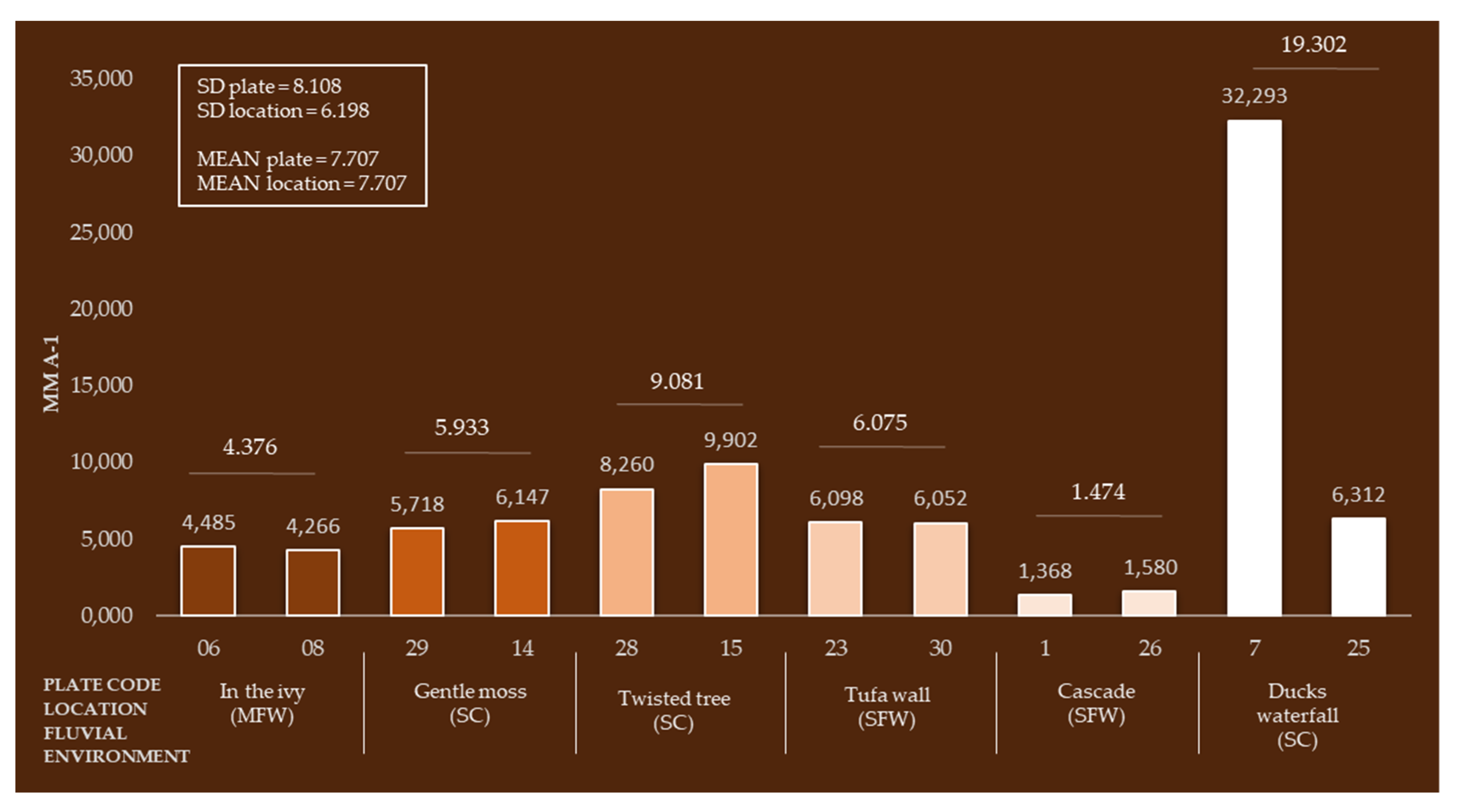
| 08 | In the ivy | 06, 08 | ACTIVE | (MFV) PLs at depth <5 cm, moderate turbulence and splashing, similar inclination. |
| 09 | Gentle moss | 29, 14 | ACTIVE | Stepped cascade (SC) pronounced turbulence, PL14 is closer to the moss |
| 10 | Twisted tree | 28, 15 | ACTIVE | (SC) pronounced turbulence, PL15 is closer to moss |
| 11 | Tufa wall | 23, 30 | ACTIVE | Slow flow velocity (SFV) depth <50 cm, no turbulence or splashing, plenty of light |
| 12 | Cascade | 01, 26 | ACTIVE | (SW) PLs at depth <30 cm, no turbulence or splashing |
| 13 | The lake of six trees | 09, 22 | DRIED UP (INACITVE) | Stagnant water (SW) PLs at depth <120 cm, no turbulence or splashing. |
| 14 | Ducks waterfall | 07, 25 | ACTIVE | (SC) PLs at depth <5 cm, moderate turbulence and splashing, PL07 is closer to the moss, an abundance of light |
| M/Y | ODO % sat | ODO mg/L | Temp °C | SpCond µS/cm | Sal ppt | Turbidity FNU | Chloro. RFU | Chloro. µg/L | BGA−PC RFU | BGA−PC µg/L | fDOM RFU | fDOM QSU | pH | ORP mV |
|---|---|---|---|---|---|---|---|---|---|---|---|---|---|---|
| 05/18 | 94.38 | 8.80 | 18.68 | 517.27 | 0.25 | 0.76 | 0.25 | 1.01 | 0.44 | 0.55 | 1.36 | 4.09 | 8.37 | 206.7 |
| 06/18 | 90.08 | 8.10 | 20.50 | 459.50 | 0.22 | 2.15 | 0.38 | 1.53 | −0.29 | −0.29 | 1.70 | 5.11 | 8.38 | 345.1 |
| 07/18 | 86.68 | 7.34 | 23.69 | 376.06 | 0.18 | 4.31 | 0.56 | 2.23 | −0.31 | −0.31 | 1.65 | 4.95 | 8.42 | 357.3 |
| 08/18 | 82.44 | 6.73 | 25.59 | 253.15 | 0.12 | 8.84 | 0.72 | 2.86 | −0.24 | −0.24 | 1.52 | 4.56 | 8.40 | 368.0 |
| 09/18 | 74.68 | 6.49 | 22.30 | 165.56 | 0.08 | 6.98 | 0.60 | 2.41 | −0.21 | −0.21 | 1.77 | 5.30 | 8.51 | 374.3 |
| 10/18 | 72.80 | 6.96 | 17.52 | 88.03 | 0.04 | 7.24 | 0.86 | 3.43 | −0.12 | −0.12 | 2.34 | 7.01 | 8.57 | 390.5 |
| 11/18 | 72.86 | 7.44 | 14.42 | 43.38 | 0.02 | 6.37 | 1.16 | 4.64 | −0.04 | −0.04 | 2.53 | 7.60 | 8.65 | 414.2 |
| 12/18 | 73.08 | 8.23 | 10.13 | 10.39 | 0.00 | 5.23 | 0.38 | 1.51 | −0.15 | −0.15 | 3.28 | 9.85 | 8.65 | 438.7 |
| 01/19 | 76.00 | 9.21 | 7.06 | 10.76 | 0.00 | 183.73 | 4.11 | 16.44 | 1.07 | 1.07 | 8.05 | 24.14 | 8.77 | 450.9 |
| 02/19 | 91.57 | 10.53 | 9.17 | 288.94 | 0.14 | 53.21 | 1.91 | 7.66 | 0.24 | 0.24 | 4.86 | 14.59 | 8.79 | 363.3 |
| 03/19 | 92.16 | 10.28 | 10.45 | 349.98 | 0.17 | 3.16 | 0.69 | 2.76 | −0.17 | −0.17 | 2.15 | 6.46 | 8.80 | 349.4 |
| 04/19 | 93.31 | 9.75 | 13.36 | 400.54 | 0.19 | 2.71 | 0.61 | 2.42 | −0.21 | −0.21 | 1.50 | 4.50 | 8.79 | 325.0 |
| 05/19 | 94.24 | 9.40 | 15.46 | 482.70 | 0.23 | 1.46 | 0.31 | 1.25 | −0.27 | −0.27 | 1.54 | 4.62 | 8.94 | 322.4 |
| MEAN | 84.04 | 8.34 | 16.32 | 278.34 | 0.13 | 20.61 | 0.93 | 3.72 | −0.04 | −0.03 | 2.60 | 7.79 | 8.65 | 360.6 |
| SD | 8.42 | 1.28 | 5.59 | 177.12 | 0.09 | 47.01 | 0.97 | 3.89 | 0.37 | 0.38 | 1.76 | 5.27 | 0.21 | 56.94 |
Publisher’s Note: MDPI stays neutral with regard to jurisdictional claims in published maps and institutional affiliations. |
© 2020 by the authors. Licensee MDPI, Basel, Switzerland. This article is an open access article distributed under the terms and conditions of the Creative Commons Attribution (CC BY) license (http://creativecommons.org/licenses/by/4.0/).
Share and Cite
Šiljeg, A.; Marić, I.; Cukrov, N.; Domazetović, F.; Roland, V. A Multiscale Framework for Sustainable Management of Tufa-Forming Watercourses: A Case Study of National Park “Krka”, Croatia. Water 2020, 12, 3096. https://doi.org/10.3390/w12113096
Šiljeg A, Marić I, Cukrov N, Domazetović F, Roland V. A Multiscale Framework for Sustainable Management of Tufa-Forming Watercourses: A Case Study of National Park “Krka”, Croatia. Water. 2020; 12(11):3096. https://doi.org/10.3390/w12113096
Chicago/Turabian StyleŠiljeg, Ante, Ivan Marić, Neven Cukrov, Fran Domazetović, and Vlatko Roland. 2020. "A Multiscale Framework for Sustainable Management of Tufa-Forming Watercourses: A Case Study of National Park “Krka”, Croatia" Water 12, no. 11: 3096. https://doi.org/10.3390/w12113096
APA StyleŠiljeg, A., Marić, I., Cukrov, N., Domazetović, F., & Roland, V. (2020). A Multiscale Framework for Sustainable Management of Tufa-Forming Watercourses: A Case Study of National Park “Krka”, Croatia. Water, 12(11), 3096. https://doi.org/10.3390/w12113096