Anthropization and Climate Change: Impact on the Discharges of Forest Watersheds in Central Africa


Abstract
:1. Introduction
2. Materials and Methods
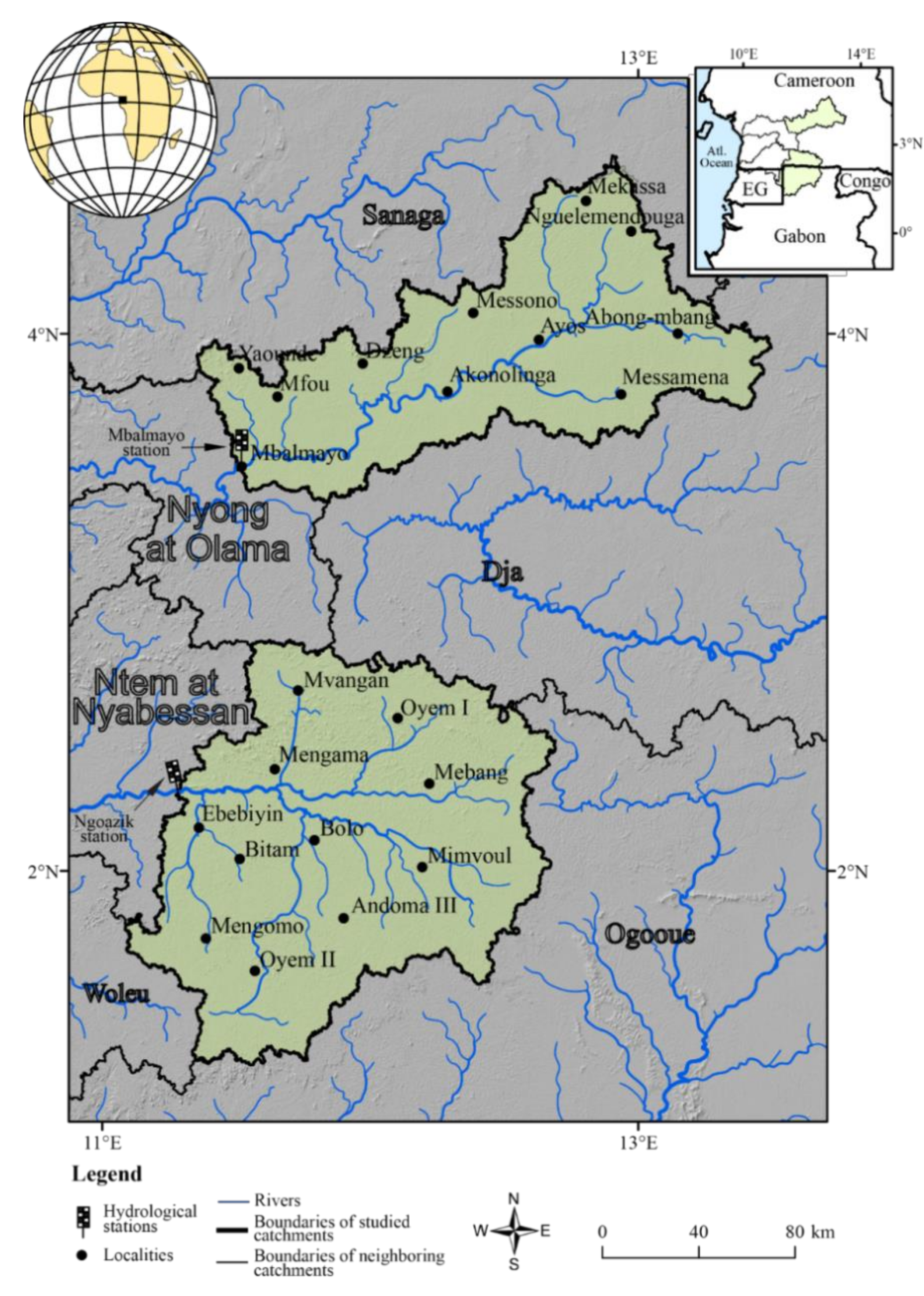
2.1. Study Area
2.2. Data Collection
2.2.1. Hydroclimatic Data
2.2.2. Spatial Data
2.3. Data Analysis
2.3.1. Hydroclimatic Data
2.3.2. Spatial Data
3. Results
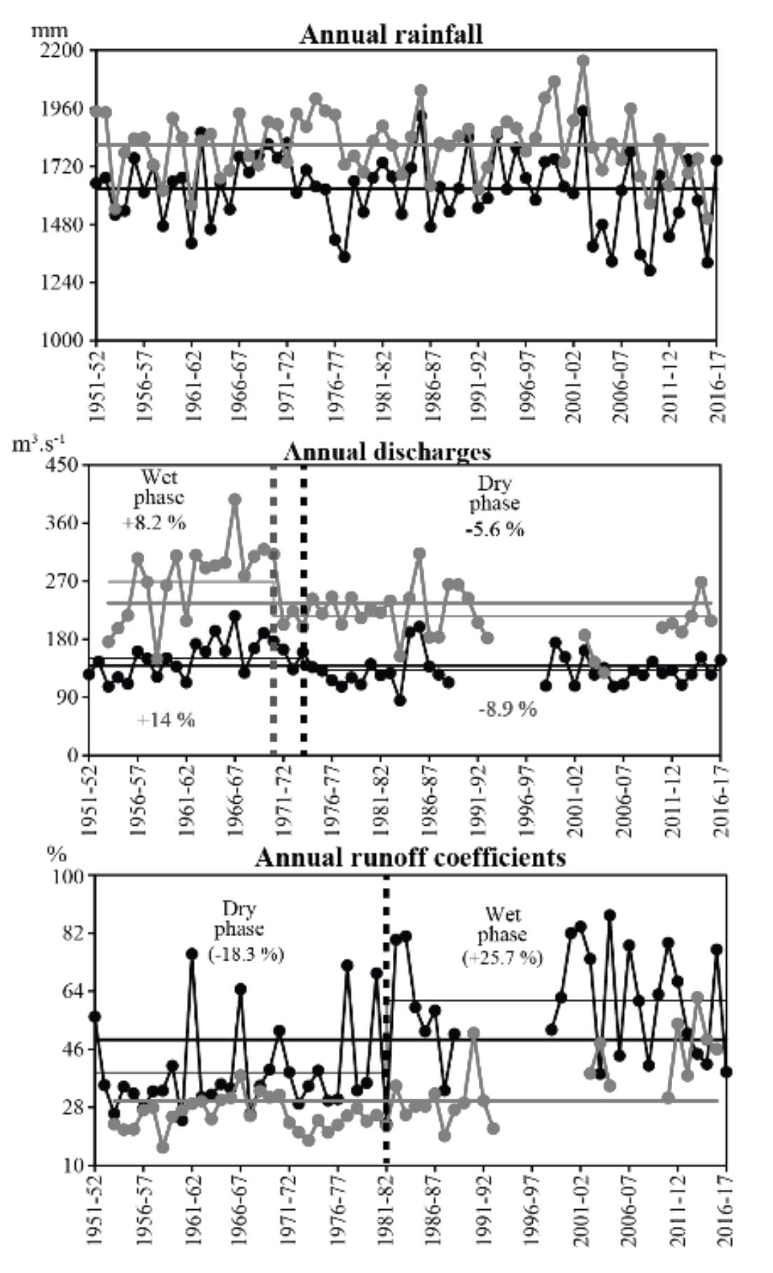
3.1. Changes in Discharges
3.1.1. Average Discharges
3.1.2. Extreme Discharges
3.2. Analysis of the Main Forces Having Important Links with Discharges
3.2.1. Rainfall Variability
Annual Rainfall
Seasonal Rainfall
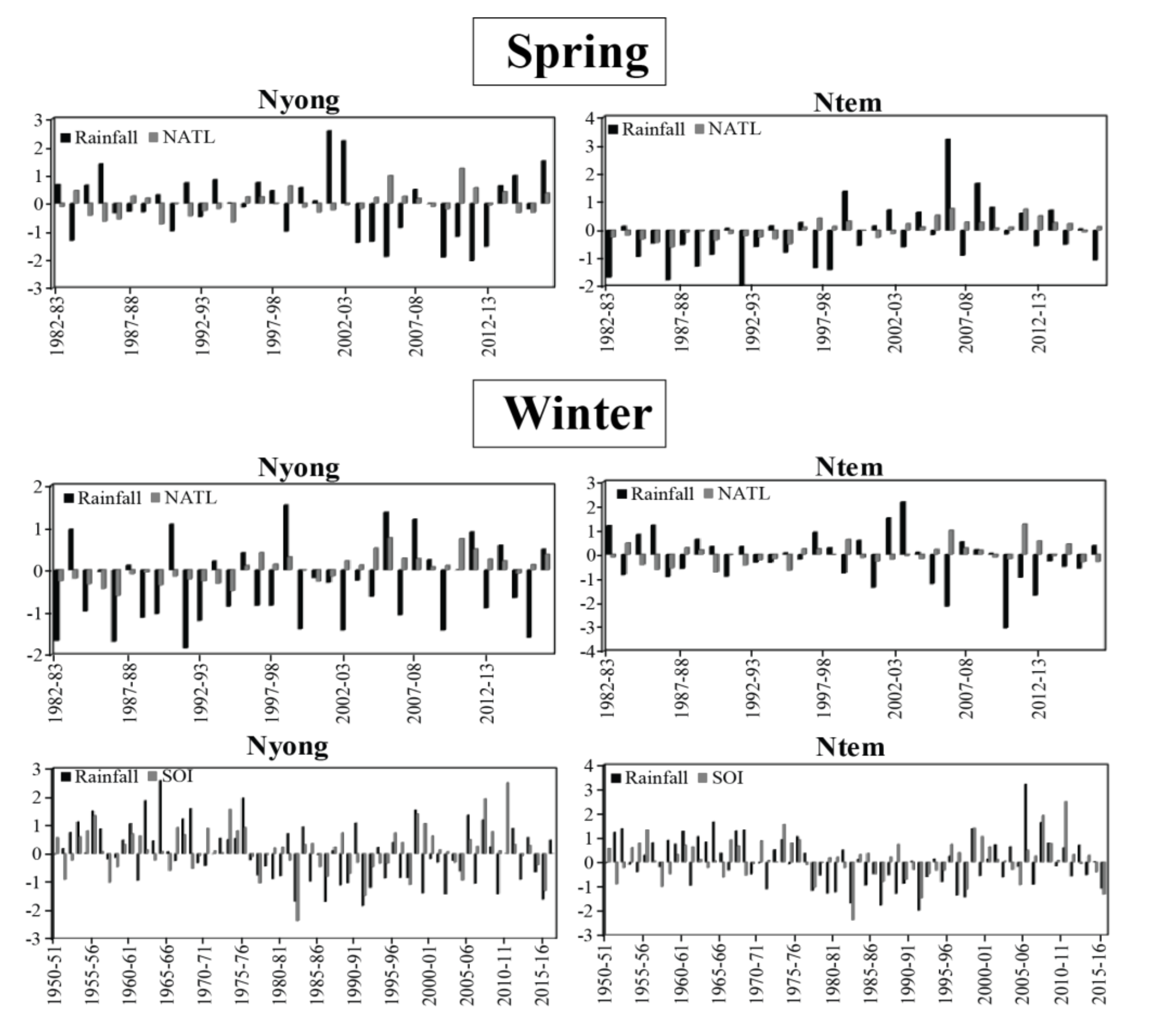
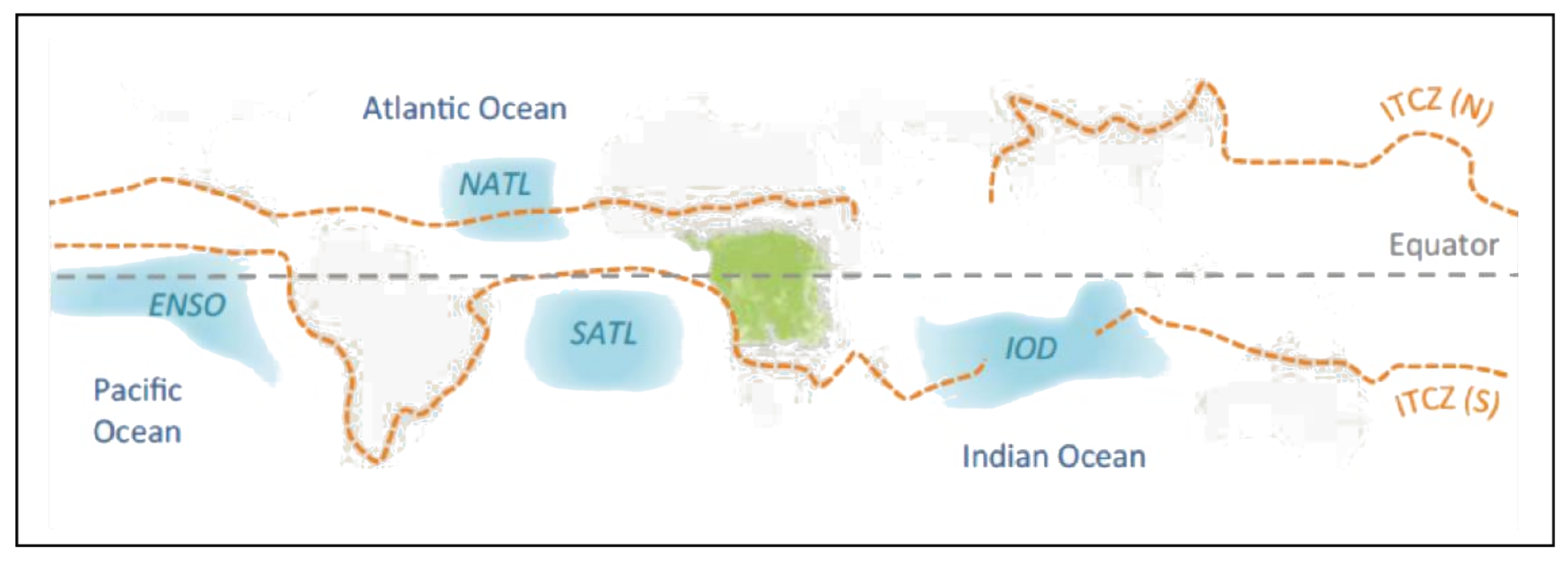
Relationships between Rainfall and Some Potential Sources of Variability
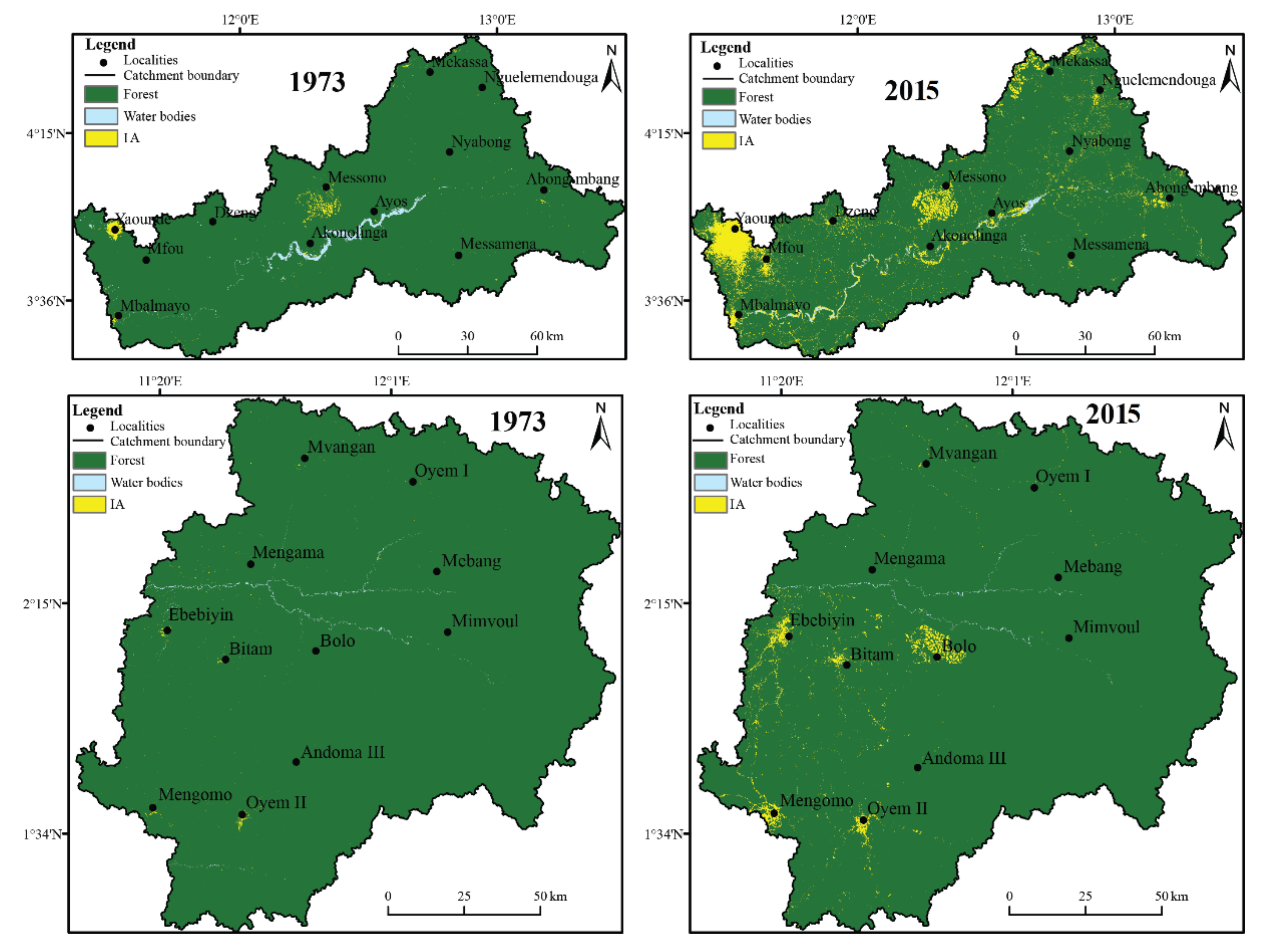
3.2.2. Land Use Dynamics in the Studied Watersheds
3.3. The Impacts of Environmental Forces on the Discharges
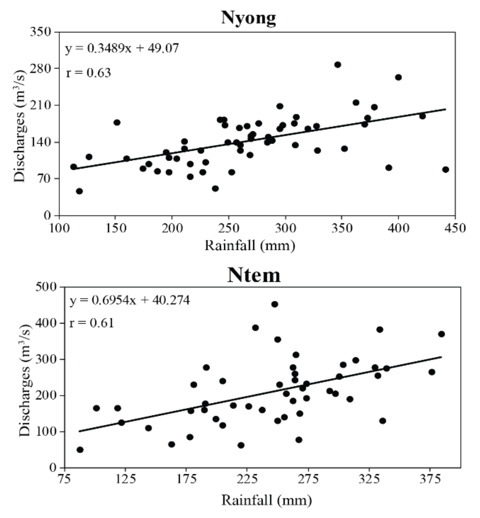
3.3.1. Rainfall
3.3.2. Changes in Land Use Patterns
4. Discussion: Analysis of Results in the Regional Context
5. Conclusions
Author Contributions
Funding
Acknowledgments
Conflicts of Interest
References
- Dzana, J.G.; Ndam, N.J.R.; Tchawa, P. The Sanaga discharge at Edea catchment outlet (Cameroon): An example of tropical rain-fed river system to change in precipitation and groundwater input and to flow regulation. River Res. Appl. 2010, 27, 754–771. [Google Scholar] [CrossRef]
- Chu, M.L.; Knouft, J.H.; Ghulam, A.; Guzman, J.A.; Pan, Z. Impacts of urbanization on river flow frequency: A controlled experimental modeling-based evaluation approach. J. Hydrol. 2013, 495, 1–12. [Google Scholar] [CrossRef]
- Rosburg, T.T.; Nelson, P.A.; Bledsoe, B.P. Effects of urbanization on flow duration and stream flashiness: A case study of Puget sound stream, Western Washington, USA. JAWRA J. Am. Water Resour. Assoc. 2017, 53, 493–507. [Google Scholar] [CrossRef]
- Aulenbach, B.T.; Landers, M.N.; Musser, J.W.; Painter, J.A. Effects of impervious area and BMP implementation and design on storm runoff and water quality on eight small watersheds. JAWRA J. Am. Water Resour. Assoc. 2017, 53, 382–399. [Google Scholar] [CrossRef]
- Diem, J.E.; Hill, T.C.; Milligan, R.A. Diverse multi-decadal changes in streamflow within a rapidly urbanizing region. J. Hydrol. 2018, 556, 61–71. [Google Scholar] [CrossRef]
- Oudin, L.; Salavati, B.; Furusho-Percot, C.; Ribstein, P.; Saadi, M. Hydrological impacts of urbanization at the catchment Scale. J. Hydrol. 2018, 559, 774–786. [Google Scholar] [CrossRef] [Green Version]
- Gibson, C.A.; Meyer, J.L.; Poff, L.E.; Georgakakos, A. Flow regime alterations under changing climate in two river basins: Implications for freshwater ecosystems. River Res. Appl. 2005, 21, 849–864. [Google Scholar] [CrossRef]
- Yira, Y.; Diekkrüger, B.; Steup, G.; Aymar, Y.B. Impact of climate change on hydrological conditions in a tropical West African catchment using an ensemble of climate simulations. Hydrol. Earth Syst. Sci. 2017, 21, 2143–2161. [Google Scholar] [CrossRef] [Green Version]
- Namugize, J.N.; Jewitt, J.; Graham, M. Effects of land use and land cover changes on water quality in the Umngeni river catchment, South Africa. Phys. Chem. Earth Parts A/B/C 2018, 105, 247–264. [Google Scholar] [CrossRef]
- Gorgoglione, A.; Gregorio, J.; Rios, A.; Alonso, J.; Chreties, C.; Fossati, M. Influence of land use/land cover on surface-water quality of Santa Lucìa river, Uruguay. Sustainability 2020, 12, 4692. [Google Scholar] [CrossRef]
- Getahun, Y.S.; Li, M.H.; Chen, P.Y. Assessing impact of climate change on hydrology of Melka Kuntrie Subbasin, Ethiopia with Ar4 and Ar5 projections. Water 2020, 12, 1308. [Google Scholar] [CrossRef]
- Olivry, J.C.; Bricquet, J.P.; Mahé, G. Vers un appauvrissement durable des ressources en eau de l’Afrique humide. In Hydrology of Warm Humid Regions, 4ème Assemblée IAHS, Yokohama, Japon, 13-15 Juillet 1993; Gladwell, J.S., Ed.; IAHS Press: Wallingford, UK, 1993; pp. 67–78. [Google Scholar]
- Bricquet, J.P.; Bamba, F.; Mahé, G.; Touré, M.; Olivry, J.C. Evolution récente des ressources en eau de l’Afrique atlantique. Rev. des Sci. L’eau 2005, 10, 321–337. [Google Scholar] [CrossRef] [Green Version]
- Servat, E.; Paturel, J.E.; Lubès-Niel, H.; Kouamé, B.; Masson, J.M.; Travaglio, M.; Marieu, B. De différents aspects de la variabilité de la pluviométrie en Afrique de l’Ouest et Centrale. Rev. des Sci. L’eau 2005, 12, 363–387. [Google Scholar] [CrossRef] [Green Version]
- Mahé, G.; L’Hôte, Y.; Olivry, J.C.; Wotling, G. Trends and discontinuities in regional rainfall of West and Central Africa—1951–1989. Hydrol. Sci. J. 2001, 46, 211–226. [Google Scholar] [CrossRef]
- Buisson, A. La grande saison sèche 1985 au Gabon. Situation climatique en Afrique intertropicale. La Météorologie 1985, 15, 5–13. [Google Scholar]
- Mahé, G.; Lerique, J.; Olivry, J.C. L’Ogooué au Gabon. Reconstitution des débits manquants et mise en évidence de variations climatiques à l’équateur. Hydrol. Cont. 1990, 5, 105–124. [Google Scholar]
- Bigot, S.; Moron, V.; Melice, J.L.; Servat, E.; Paturel, J.E. Fluctuations pluviométriques et analyse fréquentielle de la pluviosité en Afrique centrale. In Water Ressources Variability in Africa during the XXth Century, Abidjan, Côte d’ivoire, Novembre 1998; Servat, E., Hughes, D., Fritsch, J.M., Hulme, M., Eds.; IAHS Press: Wallingford, UK, 1998; pp. 71–78. [Google Scholar]
- Lienou, G.; Mahé, G.; Paturel, J.E.; Servat, E.; Sighomnou, D.; Ekodeck, G.E.; Dezetter, A.; Dieulin, C. Evolution des régimes hydrologiques en région équatoriale camerounaise: Un impact de la variabilité climatique en zone équatoriale? Hydrol. Sci. J. 2008, 53, 789–801. [Google Scholar] [CrossRef]
- Kouassi, A. Caractérisation d’une Modification Eventuelle de la Relation Pluie-Débit et ses Impacts Sur Les Ressources en eau en Afrique de l’Ouest: Cas du Bassin Versant du N’zi (Bandama) en Côte d’Ivoire. Ph.D. Thesis, Université de Cocody, Abidjan, Côte d’ivoire, 2007. [Google Scholar]
- Souley, Y.K. L’evolution De L’occupation Des Sols A L’echelle Des Bassins Versants De Wankama Et Tondi Kiboro: Quelles Consequences Sur Les Debits Et L’evapotranspiration Reelle (Etr). Master Thesis, Université Abdou Moumouni, Niamey, Niger, 2008. [Google Scholar]
- Leblanc, M.; Favreau, G.; Massuel, S.; Tweed, S.; Loireau, M.; Cappelaere, B. Land clearance and hydrological change in the Sahel: South-west Niger. Glob. Planet. Chang. 2008, 61, 49–62. [Google Scholar] [CrossRef]
- Amogu, O.; Descroix, L.; Yéro, K.S.; Le Breton, É; Mamadou, I.; Ali, A.; Vischel, T.; Bader, J.-C.; Moussa, I.B.; Gautier, E.; et al. Increasing river flows in Sahel? Water 2010, 2, 170–199. [Google Scholar] [CrossRef] [Green Version]
- Paturel, J.E.; Mahé, G.; Diello, P.; Barbier, B.; Dezetter, A.; Dieulin, C.; Karambiri, H.; Yacouba, H.; Maiga, A. Using land cover changes and demographic data to improve hydrological modeling in the Sahel. Hydrol. Process. 2017, 31, 811–824. [Google Scholar] [CrossRef] [Green Version]
- Moffo, Z.M. Contribution Des Systemes D’information Geographiques Pour La Cartographie Des Zones A Risques A Yaounde: Application Au Bassin Du Mfoundi. Master’s Thesis, Université de Yaoundé I, Yaounde, Cameroon, 2011. [Google Scholar]
- Ebodé, V.B. Etude De La Variabilite Hydroclimatique Dans Un Bassin Versant Forestier En Voie D’urbanisation Acceleree: Le Cas De La Mefou. Master’s, Université de Yaoundé I, Yaounde, Cameroun, 2017. Master’s Thesis, Université de Yaoundé I, Yaounde, Cameroun, 2017. [Google Scholar]
- Dezetter, A.; Paturel, J.E.; Ruelland, D.; Ardoin-Bardin, S.; Ferry, L.; Mahé, G.; Dieulin, C.; Servat, E. Prise en compte des variabilités spatio-temporelles de la pluie et de l’occupation du sol dans la modélisation semi-spatialisée des ressources en eau du haut fleuve Niger. In Global Change: Facing Risks and Threats to Water Resources, Proceedings of the Sixth World FRIEND Conference, Fez, Morocco, 25–29 October 2010; IAHS Press: Wallingford UK, 2010; pp. 544–552. [Google Scholar]
- Fritsch, J.M. Les Effets Du Defrichement De La Foret Amazonienne Et De La Mise En Culture Sur L’hydrologie De Petits Bassins Versants. Ph.D. Thesis, Université de Montpellier II, Montpellier, France, 1990. [Google Scholar]
- BUCREP. Rapport de présentation des résultats définitifs du recensement de la population en 2005; BUCREP: Yaoundé, Cameroun, 2011. [Google Scholar]
- Olivry, J.C. Fleuves et Rivieres du Cameroun; MESRES-ORSTOM: Paris, France, 1986. [Google Scholar]
- Letouzey, R. Notice de la Carte Phytogéographique du Cameroun au 1/500000; Institut de la carte internationale de la végétation: Toulouse, France, 1985. [Google Scholar]
- Boyer, J.F.; Dieulin, C.; Rouché, N.; Crès, A.; Servat, E.; Paturel, J.E.; Mahé, G. SIEREM: An environmental information system for water resources. In Water Resource Variability–Hydrological Impacts, Proceedings of the Fifth FRIEND World Conference, Havana, Cuba, 26 November 2006; IAHS Press: Wallingford, UK, 2006; pp. 19–25. [Google Scholar]
- Rouché, N.; Mahé, G.; Ardoin-Bardin, S.; Brissaud, B.; Boyer, J.F.; Crès, A.; Dieulin, C.; Bardin, G.; Commelard, G.; Dezetter, A.; et al. Constitution d’une grille de pluies mensuelles pour l’Afrique (période 1900-2000). Sécheresse 2010, 21, 336–338. [Google Scholar] [CrossRef]
- Paturel, J.E.; Boubacar, I.; L’Aour, A.; Mahé, G. Analyses de grilles pluviométriques et principaux traits des changements survenus au 20ème siècle en Afrique de l’Ouest et Centrale. Hydrol. Sci. J. 2010, 55, 1281–1288. [Google Scholar] [CrossRef] [Green Version]
- Dieulin, C.; Mahé, G.; Paturel, J.E.; Ejjiyar, S.; Tramblay, Y.; Rouché, N.; Mansouri, B.E. A new 60-year monthly-gridded rainfall data set for Africa. Water 2019, 11, 387. [Google Scholar] [CrossRef] [Green Version]
- Gleick, P.H. Methods for evaluating the regional hydrologic impacts of global climatic changes. J. Hydrol. 1986, 88, 97–116. [Google Scholar] [CrossRef]
- Arnell, N.W.; Reynards, N.S. The effects of climate change due to global warming on river flows in Great Britain. J. Hydrol. 1996, 183, 397–424. [Google Scholar] [CrossRef]
- Huffman, G.J.; Adler, R.F.; Bolvin, D.T.; Gu, G.; Nelkin, E.J.; Bowman, K.P.; Hong, Y.; Stocker, E.F.; Wolff, D.B. The TRMM Multisatellite Precipitation Analysis (TMPA): Quasi-Global, Multiyear, Combined-Sensor Precipitation Estimates at Fine Scales. J. Hydrom. 2007, 8, 38–55. [Google Scholar] [CrossRef]
- Bush, E.R.; Jeffery, K.; Bunnefeld, N.; Tutin, C.; Musgrave, R.; Moussavou, G.; Mihindou, V.; Malhi, Y.; Lehmann, D.; Edzang, N.J.; et al. Rare ground data confirm significant warming and drying in western equatorial Africa. PeerJ 2020, 8, e8732. [Google Scholar] [CrossRef] [Green Version]
- Lubès, H.; Masson, J.M.; Servat, E.; Paturel, J.E.; Kouame, B.; Boyer, J.F. Caractérisation des fluctuations dans une série chronologique par applications de tests statistiques. Etudes bibliographiques; Programme ICCARE, Rapport n3. ORSTOM: Montpellier, France, 1994. [Google Scholar]
- Richter, B.D.; Baumgartner, J.V.; Braun, D.P.; Powell, J. A spatial assessment of hydrologic alteration within river network. Regul. Rivers Res. Mgmt. 1998, 39, 329–340. [Google Scholar] [CrossRef]
- Mahé, G.; Lienou, G.; Descroix, L.; Bamba, F.; Paturel, J.E.; Laraque, A.; Meddi, M.; Habaieb, H.; Adegea, O.; Dieulin, C.; et al. The rivers of Africa: Witness of climate change and the human impact on the environment. Hydrol. Process. 2013, 27, 2105–2114. [Google Scholar] [CrossRef]
- Tsalefac, M.; Hiol Hiol, F.; Mahe, G.; Laraque, A.; Sonwa, D.; Sholte, P.; Pokam, W.; Haensler, A.; Beyene, T.; Ludwig, F.; et al. Climate of Central Africa: Past, present and future. In The Forests of the Congo Basin. Forests and Climate Change; De Wasseige, C., Tadoum, M., Eba’a, A.R., Doumenge, C., Eds.; Weyrich: Neufchâteau, Belgium, 2015; Volume 2, pp. 37–52. [Google Scholar]
- Bogning, S.; Frappart, F.; Paris, A.; Blarel, F.; Ninõ, F.; Picart, S.S.; Lanet, P.; Seyler, F.; Mahé, G.; Onguene, R.; et al. Hydro-climatology study of the Ogooué River basin using hydrological modeling and satellite altimetry. Adv. Space Res. 2020. [Google Scholar] [CrossRef]
- Dzana, J.G.; Amougou, J.A.; Onana, V. Modélisation spatiale des facteurs d’aggravation des écoulements liquides à Yaoundé. Application au bassin versant d’Akë. Mosella 2004, 29, 78–91. [Google Scholar]
- Tardif, S. Regionalisation Et Facteurs De La Variabilite Spatiale Des Debits Saisonniers Et Extremes Journaliers Au Quebec Meridional. Master’s Thesis, Université du Québec, Québec, Canada, 2005. [Google Scholar]
- Coe, M.T.; Costa, M.H.; Soares-Filho, B.S. The influence of historical and potential future deforestation on the streamflow of the Amazon river—Land surface processes and atmospheric feedbacks. J. Hydrol. 2009, 369, 165–1774. [Google Scholar] [CrossRef]
- Dias, L.C.; Macedo, M.N.; Costa, M.H.; Coe, M.T.; Neil, C. Effects of land cover change on evapotranspiration and streamflow of small catchments in the Upper Xingu river basin, Central Brazil. J. Hydrol. 2015, 4, 108–122. [Google Scholar] [CrossRef] [Green Version]
- Lee, E.; Livino, A.; Han, S.C.; Zhang, K.; Briscoe, J.; Kelman, J.; Moorcroft, P. Land cover change explains the increasing discharge of the Paraná river. Reg. Env. Chang. 2018, 18, 1871–1881. [Google Scholar] [CrossRef] [Green Version]
- Sighomnou, D. Analyse Et Redefinition Des Regimes Climatiques Et Hydrologiques Du Cameroun: Perspectives D’evolution Des Ressources En Eau. Ph.D. Thesis, Université de Yaoundé I, Yaoundé, Cameroun, 2004. [Google Scholar]
- Amougou, J.A.; Ndam, N.J.R.; Djocgoue, P.F.; Bessoh, B.S. Variabilité climatique et régime hydrologique dans un milieu bioclimatique de transition: Cas du bassin fluvial de la Sanaga. Afr. Sci. 2015, 11. Available online: https://www.semanticscholar.org/paper/Variabilit%C3%A9-climatique-et-r%C3%A9gime-hydrologique-dans-Amougou-Ngoupayou/614a4602790ca1b9c87683c0bb1234ffdbfd7551 (accessed on 15 September 2020).
- Panthou, G.; Lebel, T.; Vishel, T.; Quantin, G.; Sane, Y.; Ba, A.; Ndiaye, O.; Diongue-Niang, A.; Diopkane, M. Rainfall intensification in tropical semi-arid regions: The Sahelian case. Environ. Res. Lett. 2018, 13. [Google Scholar] [CrossRef]
- Conway, D.P.; Persechino, A.; Ardoin–Bardin, S.; Hamandawana, H.; Dieulin, C.; Mahé, G. Rainfall and river flow variability in sub-saharan Africa during the 20th century. J. Hydrom. 2009, 10, 41–59. [Google Scholar] [CrossRef]
- Mahé, G.; Citeau, J. Interactions between the Ocean, Atmosphere and Continent in Africa, Related to the Atlantic Monsoon Flow: General Pattern and the 1984 Case Study. Veille Clim. Satell. 1993, 44, 34–54. [Google Scholar]
- Nicholson, E.N.; Dezfuli, A.K. The relationship of rainfall variability in western equatorial Africa to the tropical oceans and atmospheric circulation. Part I: The boreal Spring. J. Clim. 2013, 26, 45–65. [Google Scholar] [CrossRef]
- Nicholson, E.N.; Dezfuli, A.K. The relationship of rainfall variability in western equatorial Africa to the tropical oceans and atmospheric circulation. Part II: The boreal Autumn. J. Clim. 2013, 26, 66–84. [Google Scholar] [CrossRef]
- Mahé, G.; Leduc, C.; Amani, A.; Paturel, J.E.; Girard, S.; Servat, E.; Dezetter, A. Augmentation récente du ruissellement de surface en région soudano-sahélienne et impact sur les ressources en eau. In Hydrology of the Mediterranean and Semiarid Regions; Servat, E., Najem, W., Leduc, C., Shakeel, A., Eds.; IAHS Press: Wallingford, UK, 2003; pp. 215–222. [Google Scholar]
- Kergoat, L.; Hiernaux, P.; Baup, F.; Boulain, N.; Cappelaere, B.; Cohard, J.M.; Descroix, L.; Galle, S.; Guilbert, S.; Guichard, F.; et al. Land surface in AMMA Extending Ecosystem, Energy and Water Balance Studies in Space and Time is Some-Times Surprising. In Proceedings of the 2nd International Conference of AMMA Program, Karlsruhe, Germany, 26–30 November 2007. [Google Scholar]
- D’Orgeval, T.; Polcher, J. Impacts of precipitation events and land-use changes on West African river discharges during the years 1951–2000. Clim. Dyn. 2008, 31, 249–262. [Google Scholar] [CrossRef]
- Mahé, G.; Olivry, J.C.; Servat, E. Sensibilité des cours d’eau ouest-africains aux changements climatiques et environnementaux: Extrêmes et paradoxes. In Regional Hydrological Impacts of Climatic Change—Hydroclimatic Variability, Proceedings of symposium S6 held during the Seventh IAHS Scientific Assembly, Foz do Iguaçu, Brazil, 3–9 April 2005; IAHS Press: Wallingford, UK, 2005; pp. 167–177. [Google Scholar]
- Li, K.Y.; Coe, M.T.; Ramankutty, N.; De jong, R. Modeling the hydrological impact of land–use change in West Africa. J. Hydrol. 2007, 337, 258–268. [Google Scholar] [CrossRef]
- Tellro Wai, N.; Ngatcha, B.N.; Mahe, G.; Doumnang, J.C.; Delclaux, F.; Ngolona, G.; Genthon, P. Influence des activités anthropiques sur le régime hydrologique du fleuve Logone de 1960 à 2000. In Hydrology in a Changing World: Environmental and Human Dimensions, Proceedings of FRIEND-Water 2014, Montpellier, France, 7–10 October 2014; Daniell, T., van Lanen, H.A.J., Demuth, S., Laaha, G., Servat, E., Mahe, G., Boyer, J.F., Paturel, J.E., Dezetter, A., Ruelland, D., Eds.; IAHS Press: Wallingford, UK, 2014; pp. 438–442. [Google Scholar]


| Periods | Whole Period | Discontinuity | Mean (m3/s) | Cv (%) | |||
|---|---|---|---|---|---|---|---|
| Mean (m3/s) | Cv (%) | Before | After | Before | After | ||
| Rainfall | |||||||
| Nyong | |||||||
| Annual | 1627 | 9 | - | - | - | - | - |
| Spring | 634 | 13 | - | - | - | - | - |
| Summer | 274 | 28 | 1964–65 | 220 | 290 | 26 | 26 |
| Autumn | 625 | 11 | - | - | - | - | - |
| Winter | 93 | 43 | 1975–76 | 116 | 78 | 29 | 48 |
| Ntem | |||||||
| Annual | 1810 | 7 | - | - | - | - | - |
| Spring | 675 | 12 | - | - | - | - | - |
| Summer | 256 | 29 | 1964–65 | 192 | 283 | 29 | 22 |
| Autumn | 693 | 10 | - | - | - | - | - |
| Winter | 184 | 28 | 1976–77 | 208 | 169 | 20 | 32 |
| Discharges | |||||||
| Nyong | |||||||
| Annual | 139 | 20 | 1973–74 | 151 | 132 | 19 | 18 |
| Spring | 88 | 31 | 1973–74 | 105 | 76 | 28 | 27 |
| Summer | 111 | 31 | - | - | - | - | - |
| Autumn | 243 | 23 | - | - | - | - | - |
| Winter | 123 | 20 | - | - | - | - | - |
| Ntem | |||||||
| Annual | 236 | 23 | 1970–71 | 269 | 215 | 26 | 18 |
| Spring | 222 | 34 | 1970–71 | 270 | 193 | 32 | 28 |
| Summer | 115 | 49 | - | - | - | - | - |
| Autumn | 421 | 25 | 1990–91 | 444 | 324 | 22 | 18 |
| Winter | 156 | 29 | 1970–71 | 186 | 136 | 25 | 23 |
| Nyong Watershed | |||
| Image from 1973 | Image from 2015 | ||
| Classes Assessed | TDI | Classes Assessed | TDI |
| Forest-IA | 2 | Forest-IA | 2 |
| Forest-WB | 1.92 | Forest-WB | 1.98 |
| WB-Forest | 1.92 | WB-Forest | 1.97 |
| WB-IA | 2 | WB-IA | 2 |
| IA-Forest | 2 | IA-Forest | 2 |
| IA-WB | 2 | IA-WB | 2 |
| Ntem watershed | |||
| Image from 1973 | Image from 2015 | ||
| Classes assessed | TDI | Classes assessed | TDI |
| Forest-IA | 2 | Forest-IA | 2 |
| Forest-WB | 1.97 | Forest-WB | 1.98 |
| WB-Forest | 1.96 | WB-Forest | 1.98 |
| WB-IA | 2 | WB-IA | 2 |
| IA-Forest | 2 | IA-Forest | 2 |
| IA-WB | 2 | IA-WB | 2 |
| Basins | Decades | Deviations from the Whole Period Average (%) | ||||
|---|---|---|---|---|---|---|
| Annual | Spring | Summer | Autumn | Winter | ||
| Rainfall | ||||||
| Nyong | 1950–59 | 0.2 | 3.2 | −20.3 | 3.2 | 19.9 |
| 1960–69 | 2.2 | 0.9 | −3.1 | 1.4 | 32 | |
| 1970–79 | −1 | −1.8 | −2.9 | −0.1 | 3.6 | |
| 1980–89 | 1.5 | 0.8 | 10.5 | 2.1 | −24 | |
| 1990–99 | 4.5 | 2.1 | 23.8 | 2.9 | −16.1 | |
| 2000–09 | −5.1 | −3.4 | −0.3 | −8.6 | −10.5 | |
| 2010–16 | −3.1 | −3.7 | −9.4 | 0.9 | −7.3 | |
| Ntem | 1950–59 | −0.2 | 3.8 | −30.5 | 3.5 | 12 |
| 1960–69 | −1.7 | 2.2 | −14.9 | −5.6 | 15.9 | |
| 1970–79 | 2.3 | 0.6 | 1.9 | 5.9 | −4.6 | |
| 1980–89 | 0.5 | 2.3 | 15.9 | −0.6 | −23.7 | |
| 1990–99 | 2.5 | −1.2 | 30.2 | −0.2 | −14.5 | |
| 2000–09 | 0.1 | −2.8 | 6.8 | −2.1 | 13.8 | |
| 2010–15 | −5.9 | −7.7 | −12.7 | −2.2 | −4.7 | |
| Discharges | ||||||
| Nyong | 1951–59 | −4.8 | 10.2 | 1.3 | −14 | −4.3 |
| 1960–69 | 17.7 | 27.3 | 22.5 | 13.1 | 14.9 | |
| 1970–79 | −2.6 | 0.1 | −12.7 | 0.9 | −6 | |
| 1980–88 | −0.7 | −8.8 | −11 | 8.1 | −3.6 | |
| 2000–09 | −6.5 | −14.7 | 0.8 | −4 | −7.8 | |
| 2010–16 | −5.7 | −12.3 | −8.1 | −7.4 | 7.4 | |
| Ntem | 1953–59 | −4.4 | 0.2 | −27.6 | −7.6 | 3.4 |
| 1960–69 | 27.8 | 38.1 | 34.4 | 17.1 | 29.3 | |
| 1970–79 | −2.2 | −3.5 | −8.1 | −0.4 | −5.2 | |
| 1980–89 | −2.7 | −17.4 | −0.4 | 11.5 | −12.1 | |
| 1990 | - | - | - | - | - | |
| 2000 | - | - | - | - | - | |
| 2010–15 | −9.1 | 0.2 | −12.9 | −15.7 | −10.4 | |
| Runoff Coefficients | ||||||
| Nyong | 1951–59 | −41.3 | 5.8 | 24.7 | −27.9 | −51.2 |
| 1960–69 | −34.2 | 20.7 | 12.5 | 12 | −48.7 | |
| 1970–79 | −34.5 | −3.9 | −15.9 | 7.8 | −44.7 | |
| 1980–88 | 64.5 | −8.1 | −31.4 | 8.8 | 84.1 | |
| 2000–09 | 36.1 | −6.2 | 13.8 | 9.2 | 44.4 | |
| 2010–16 | 25.1 | −4.2 | −1.3 | −12.8 | 34.5 | |
| Ntem | 1953–59 | −13.9 | −1.6 | 8.8 | −15.2 | −21.7 |
| 1960–69 | 12.2 | 33.8 | 42.9 | 20.8 | −7.3 | |
| 1970–79 | −11.2 | −7.6 | −14.1 | −1.2 | −15.7 | |
| 1980–89 | 2.3 | −20.8 | −23.4 | 10.6 | 11.4 | |
| 1990 | - | - | - | - | - | |
| 2000 | - | - | - | - | - | |
| 2010–15 | 31.5 | 24 | −14.3 | −11.4 | 93.1 | |
| IHA Statistics | Means (m3/s) | Cv (%) | Change | |||
|---|---|---|---|---|---|---|
| Before Discontinuity | After Discontinuity | Before Discontinuity | After Discontinuity | m3/s | % | |
| Nyong | ||||||
| Minimum flows | ||||||
| 1-day minimum | 25.5 | 17.9 | 30 | 41 | −7.5 | −29.7 |
| 3-day minimum | 26.1 | 18.1 | 30 | 41 | −8 | −30.6 |
| 7-day minimum | 27.8 | 19.3 | 30 | 38 | −8.4 | −30.2 |
| 30-day minimum | 41.5 | 26.4 | 28 | 36 | −15 | −36.2 |
| 90-day minimum | 82.9 | 58.5 | 31 | 29 | −24.3 | −29.3 |
| Maximum flows | ||||||
| 1-day maximum | 366 | 366 | 26 | 23 | −0.3 | −0.08 |
| 3-day maximum | 363 | 365 | 26 | 23 | 2 | 0.55 |
| 7-day maximum | 361 | 362 | 26 | 23 | 1.3 | 0.36 |
| 30-day maximum | 340 | 338 | 26 | 25 | −2.6 | −0.76 |
| 90-day maximum | 274 | 271 | 25 | 25 | −2.3 | −0.84 |
| Average Julian dates | ||||||
| Of minimum | 61 | 67 | ||||
| Of maximum | 318 | 309 | ||||
| Ntem | ||||||
| Minimum flows | ||||||
| 1-day minimum | 48 | 34.4 | 51 | 61 | −13.5 | −28.3 |
| 3-day minimum | 50.24 | 36.2 | 51 | 60 | −14 | −27.9 |
| 7-day minimum | 53.1 | 38.9 | 51 | 56 | −14.1 | −26.5 |
| 30-day minimum | 68.71 | 53.8 | 45 | 39 | −14.8 | −21.5 |
| 90-day minimum | 128.4 | 107 | 33 | 29 | −20.8 | −16.2 |
| Maximum flows | ||||||
| 1-day maximum | 793.6 | 662 | 23 | 29 | −131 | −16.5 |
| 3-day maximum | 785.4 | 656 | 23 | 30 | −128 | −16.3 |
| 7-day maximum | 767.4 | 640 | 24 | 30 | −126 | −16.4 |
| 30-day maximum | 685.7 | 567 | 22 | 32 | −118 | −17.2 |
| 90-day maximum | 516.7 | 426 | 22 | 29 | −90 | −17.4 |
| Average Julian dates | ||||||
| Of minimum | 147 | 102 | ||||
| Of maximum | 291 | 275 | ||||
| Watersheds | Indices | Annual | Spring | Summer | Autumn | Winter |
|---|---|---|---|---|---|---|
| Ntem | DMI | −0.05 | −0.15 | 0.22 | −0.1 | −0.06 |
| NATL | −0.03 | −0.52 | −0.04 | −0.02 | 0.58 | |
| SATL | −0.06 | −0.05 | 0.06 | −0.2 | 0.43 | |
| SOI | 0.03 | −0.17 | 0.12 | −0.09 | 0.51 | |
| Nyong | DMI | −0.23 | −0.09 | 0.09 | −0.23 | −0.02 |
| NATL | −0.17 | −0.54 | −0.09 | −0.11 | 0.52 | |
| SATL | 0 | −0.08 | 0.14 | −0.12 | 0.36 | |
| SOI | 0.21 | −0.04 | 0.1 | 0.16 | 0.53 |
| Watersheds | NATL&Rainfall (Spring) | NATL&Rainfall (Winter) | SOI&Rainfall (Winter) | ||||||
|---|---|---|---|---|---|---|---|---|---|
| NY | NYOS | % | NY | NYSS | % | NY | NYSS | % | |
| Nyong | 34 | 24 | 71 | 34 | 23 | 62 | 65 | 35 | 54 |
| Ntem | 33 | 23 | 70 | 33 | 20 | 61 | 64 | 42 | 66 |
| Basins | Land Use Modes | Area Occupied in the Basin (km2) | Change | ||
|---|---|---|---|---|---|
| 1973 | 2015 | km2 | % | ||
| Forest | 14,174 | 13,326 | −848 | −6 | |
| Nyong | Water bodies | 146 | 84 | −62 | −42 |
| IA | 118 | 1028 | 910 | 771 | |
| Forest | 19,469 | 19,301 | −168 | −1 | |
| Ntem | Water bodies | 53 | 36 | −17 | −32 |
| IA | 41 | 226 | 185 | 451 | |
© 2020 by the authors. Licensee MDPI, Basel, Switzerland. This article is an open access article distributed under the terms and conditions of the Creative Commons Attribution (CC BY) license (http://creativecommons.org/licenses/by/4.0/).
Share and Cite
Ebodé, V.B.; Mahé, G.; Dzana, J.G.; Amougou, J.A. Anthropization and Climate Change: Impact on the Discharges of Forest Watersheds in Central Africa. Water 2020, 12, 2718. https://doi.org/10.3390/w12102718
Ebodé VB, Mahé G, Dzana JG, Amougou JA. Anthropization and Climate Change: Impact on the Discharges of Forest Watersheds in Central Africa. Water. 2020; 12(10):2718. https://doi.org/10.3390/w12102718
Chicago/Turabian StyleEbodé, Valentin Brice, Gil Mahé, Jean Guy Dzana, and Joseph Armathé Amougou. 2020. "Anthropization and Climate Change: Impact on the Discharges of Forest Watersheds in Central Africa" Water 12, no. 10: 2718. https://doi.org/10.3390/w12102718
APA StyleEbodé, V. B., Mahé, G., Dzana, J. G., & Amougou, J. A. (2020). Anthropization and Climate Change: Impact on the Discharges of Forest Watersheds in Central Africa. Water, 12(10), 2718. https://doi.org/10.3390/w12102718