Spatial and Temporal Patterns of Rainfall Erosivity in the Tibetan Plateau


Abstract
1. Introduction
2. Materials and Methods
2.1. Study Area
2.2. Collection of Rainfall Data
2.3. Methodology
2.3.1. Calculation of Rainfall Erosivity
2.3.2. Trend Coefficient and Climate Tendency Rate
2.3.3. Mann–Kendall Trend Test
2.3.4. Sen’s Slope Estimator
3. Results
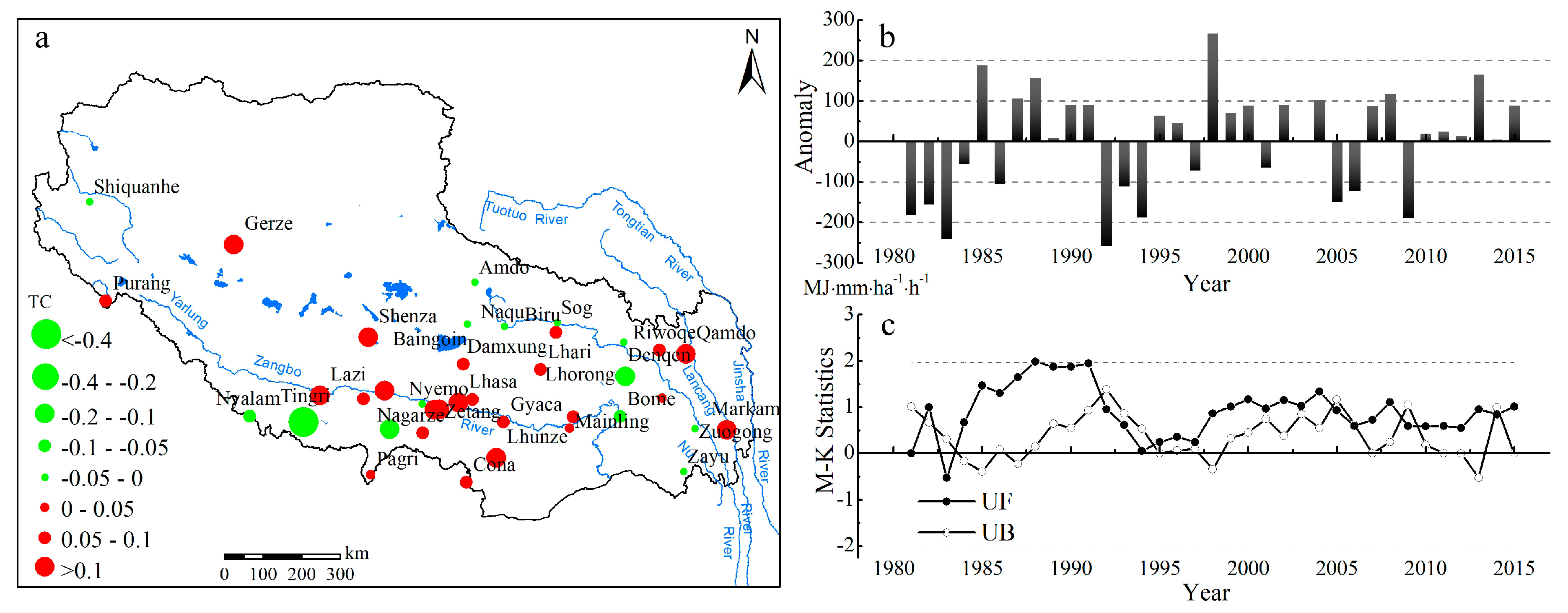
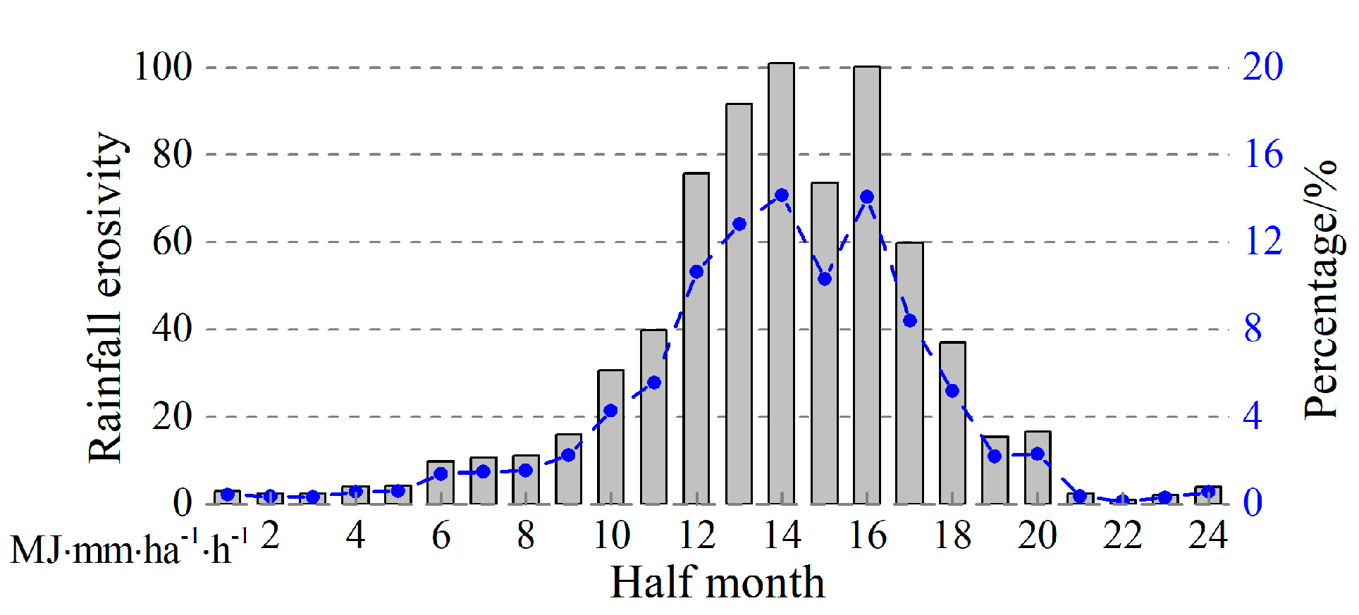
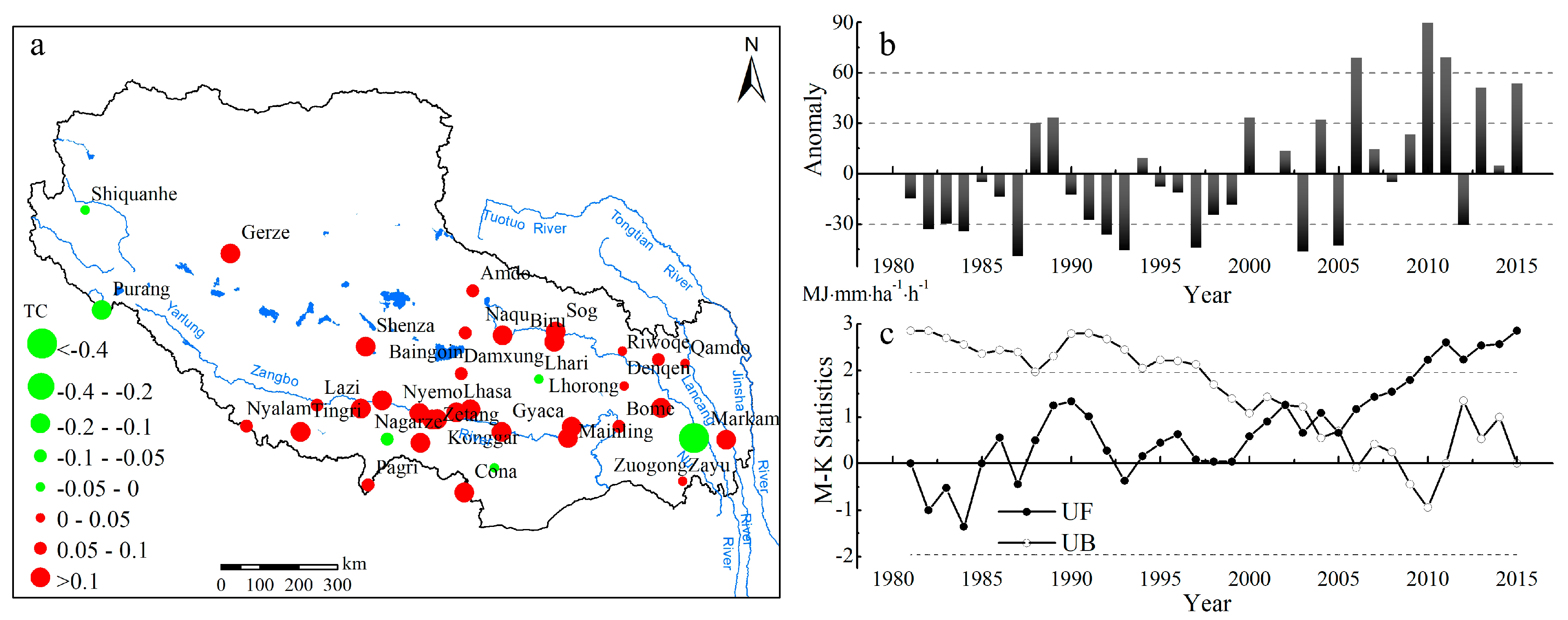
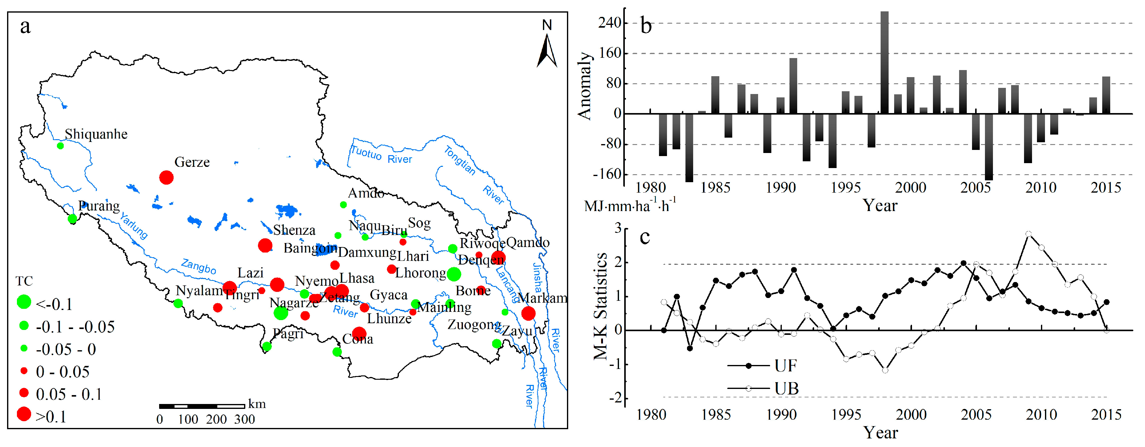
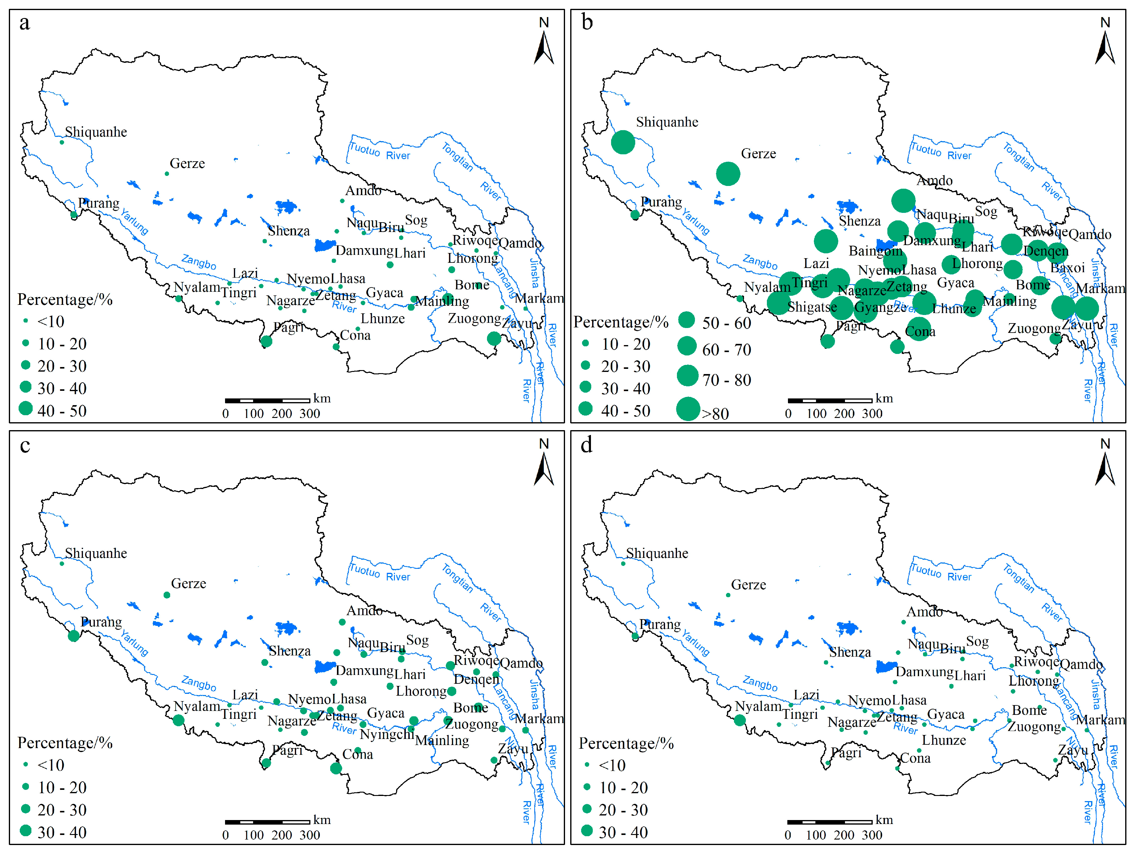
3.1. Temporal Variability in Rainfall Erosivity
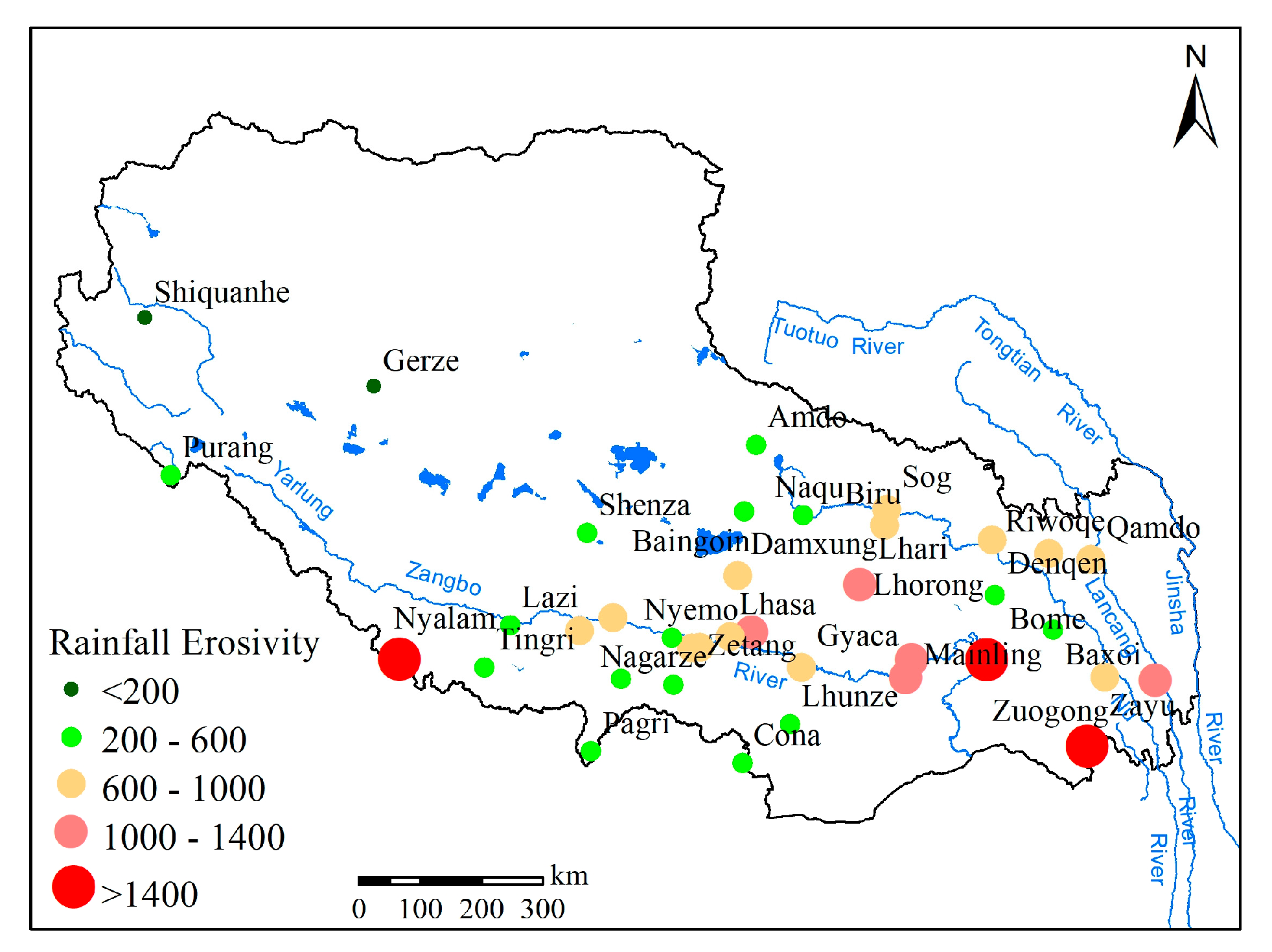
3.2. Spatial Distribution of Rainfall Erosivity in the Tibetan Plateau
4. Discussion
5. Conclusions
Author Contributions
Funding
Acknowledgments
Conflicts of Interest
References
- Pimentel, D. Soil erosion: A food and environmental threat. Environ. Dev. Sustain. 2006, 8, 119–137. [Google Scholar] [CrossRef]
- Smith, P.; House, J.I.; Bustamante, M.; Sobocká, J.; Harper, R.; Pan, G.; West, P.C.; Clark, J.M.; Adhya, T.; Rumpel, C.; et al. Global change pressures on soils from land use and management. Glob. Chang. Biol. 2016, 22, 1008–1028. [Google Scholar] [CrossRef]
- Borrelli, P.; Robinson, D.A.; Fleischer, L.R.; Lugato, E.; Ballabio, C.; Alewell, C.; Meusburger, K.; Modugno, S.; Schütt, B.; Ferro, V.; et al. An assessment of the global impact of 21st century land use change on soil erosion. Nat. Commun. 2017, 8, 2013. [Google Scholar] [CrossRef]
- Wischmeier, W.H.; Smith, D.D. Rainfall energy and its relationship to soil loss. Trans. AGU 1958, 39, 285–291. [Google Scholar] [CrossRef]
- Wischmeier, W.H. A rainfall erosion index for a universal soil loss equation. Soil Sci. Soc. Am. J. 1959, 23, 246–249. [Google Scholar] [CrossRef]
- Hudson, N. Soil Conservation; Cornell University Press: Ithaca, NY, USA, 1971. [Google Scholar]
- Wischmeier, W.H.; Smith, D.D. Predicting Rainfall Erosion Losses: A Guide to Conservation Planning; Agriculture Handbook 537; U.S. Department of Agriculture, Agricultural Research Service: Washington, DC, USA, 1978.
- Renard, K.G.; Foster, G.R.; Weesies, G.A.; McCool, D.K.; Yoder, D.C. Predicting Soil Erosion by Water: A Guide to Conservation Planning with the Revised Universal Soil Loss Equation (RUSLE); United States Department of Agriculture: Washington, DC, USA, 1997.
- Kinnell, P.I.A.; Risse, L.M. USLE-M: Empirical modeling rainfall erosion through runoff and sediment concentration. Soil Sci. Soc. Am. J. 1998, 62, 1667–1672. [Google Scholar] [CrossRef]
- Foster, G.R. User’s Reference Guide: Revised Universal Soil Loss Equation (RUSLE2); U.S. Department of Agriculture, Agricultural Research Service: Washington, DC, USA, 2004.
- Liu, B.Y.; Guo, S.Y.; Li, Z.G. China’s hydraulic erosion sampling survey. Soil Water Conserv. China 2013, 10, 26–34. (In Chinese) [Google Scholar]
- Panagos, P.; Borrelli, P.; Poesen, J.; Ballabio, C.; Lugato, E.; Meusburger, K.; Montanarella, L.; Alewell, C. The new assessment of soil loss by water erosion in Europe. Environ. Sci. Policy 2015, 54, 438–447. [Google Scholar] [CrossRef]
- Mikhailova, E.A.; Bryant, R.B.; Schwager, S.J.; Smith, S.D. Predicting rainfall erosivity in Honduras. Soil Sci. Am. J. 1997, 61, 273–279. [Google Scholar] [CrossRef]
- Shi, D.M.; Jiang, D.; Lu, X.P.; Jiang, G.Y. Temporal distribution characteristics of rainfall erosivity in Fuling District, Chongqing. Trans. CSAE 2008, 24, 16–21. (In Chinese) [Google Scholar]
- Bonilla, C.A.; Vidal, K.L. Rainfall erosivity in Central Chile. J. Hydrol. 2011, 410, 126–133. [Google Scholar] [CrossRef]
- Lee, J.H.; Heo, J.H. Evaluation of estimation methods for rainfall erosivity based on annual precipitation in Korea. J. Hydrol. 2011, 409, 30–48. [Google Scholar] [CrossRef]
- Alipour, Z.T.; Mahdian, M.H.; Pazira, E.; Hakimkhani, S.; Saeedi, M. The determination of the best rainfall erosivity index for Namak Lake Basin and evaluation of spatial variations. J. Basic Appl. Sci. Res. 2012, 2, 484–494. [Google Scholar]
- Renard, K.G.; Freimund, J.R. Using monthly precipitation data to estimate the R-factor in the revised USLE. J. Hydrol. 1994, 157, 287–306. [Google Scholar] [CrossRef]
- Oduro-Afriyie, K. Rainfall erosivity map for Ghana. Geoderma 1996, 74, 161–166. [Google Scholar] [CrossRef]
- Ferro, V.; Porto, P.; Yu, B. A comparative study of rainfall erosivity estimation for southern Italy and southeastern Australia. Hydrol. Sci. J. 1999, 44, 3–24. [Google Scholar] [CrossRef]
- Richardson, C.W.; Forster, G.R.; Wright, D.A. Estimation of erosion index from daily rainfall amount. Trans. ASABE 1983, 26, 153–156. [Google Scholar] [CrossRef]
- Yu, B.; Rosewell, C.J. An assessment of a daily rainfall erosivity model for New South Wales. Soil Res. 1996, 34, 139–152. [Google Scholar] [CrossRef]
- Zhang, W.B.; Xie, Y.; Liu, B.Y. Rainfall erosivity estimation using daily rainfall amounts. Sci. Geogr. Sin. 2002, 22, 705–711. (In Chinese) [Google Scholar]
- Petkovsek, G.; Mikos, M. Estimating the R factor from daily rainfall data in the sub-Mediterranean climate of southwest Slovenia. Hydrolog. Sci. J. 2004, 49, 869–877. [Google Scholar] [CrossRef]
- Angulo-Martinez, M.; Begueria, S. Estimating rainfall erosivity from daily precipitation records: A comparison among methods using data from the Ebro Basin (NE Spain). J. Hydrol. 2009, 379, 111–121. [Google Scholar] [CrossRef]
- Mannaerts, C.M.; Gabriels, D. Rainfall erosivity in Cape Verde. Soil Tillage. Res. 2000, 55, 207–212. [Google Scholar] [CrossRef]
- Yin, S.Q.; Xie, Y.; Wang, C.G. Calculation of rainfall erosivity by using hourly rainfall data. Geogr. Res. 2007, 26, 541–547. (In Chinese) [Google Scholar]
- Hamlaoui-Moulai, L.; Mesbah, M.; Souag-Gamane, D.; Medjerab, A. Detecting hydro-climatic change using spatiotemporal analysis of rainfall time series in Western Algeria. Nat. Hazards. 2013, 65, 1293–1311. [Google Scholar] [CrossRef]
- Ramos, M.C.; Durán, B. Assessment of rainfall erosivity and its spatial and temporal variabilities: Case study of the Penedès area (NE Spain). Catena 2014, 123, 135–147. [Google Scholar] [CrossRef]
- Silva, A.M. Rainfall erosivity map for Brazil. Catena 2004, 57, 251–259. [Google Scholar] [CrossRef]
- Vallebona, C.; Pellegrino, E.; Frumento, P.; Bonari, E. Temporal trends in extreme rainfall intensity and erosivity in the Mediterranean region: A case study in southern Tuscany, Italy. Clim. Chang. 2015, 128, 139–151. [Google Scholar] [CrossRef]
- Zhang, W.B.; Xie, Y.; Liu, B.Y. Spatial distribution of rainfall erosivity in China. J. Mt. Sci. 2003, 21, 33–40. (In Chinese) [Google Scholar]
- Liu, B.T.; Tao, H.P.; Song, C.F.; Guo, B.; Shi, Z.; Zhang, C.; Kong, B.; He, B. Temporal and spatial variations of rainfall erosivity in China during 1960 to 2009. Geogr. Res. 2013, 32, 245–256. (In Chinese) [Google Scholar]
- Yin, S.Q.; Zhang, W.B.; Xie, Y.; Liu, S.H.; Liu, F. Spatial distribution of rainfall erosivity in China based on high density battle network. Soil Water Conserv. China 2013, 10, 45–50. (In Chinese) [Google Scholar]
- IPCC. Working Group I Contribution to the IPCC Fifth Assessment Report, Climate Change 2013: The Physical Science Basis: Summary for Policymakers. Available online: http://www.climatechange2013.org/report/ (accessed on 28 October 2013).
- Sun, H.L.; Zheng, D. The Formation, Evolution and Development of the Qinghai-Tibet Plateau; Science and Technology Press: Guangzhou, China, 1998. (In Chinese) [Google Scholar]
- Sun, K.H.; Zeng, X.D.; Li, F. Climate change characteristics in ecological fragile zones in China during 1980–2014. Clim. Environ. Res. 2019, 24, 455–468. (In Chinese) [Google Scholar]
- Huang, X.L.; Zhang, T.B.; Yi, G.H.; He, D.; Zhou, X.B.; Li, J.J.; Bie, X.J.; Miao, J.Q. Dynamic Changes of NDVI in the Growing Season of the Tibetan Plateau During the Past 17 Years and Its Response to Climate Change. Int. J. Environ. Res. Public Health 2019, 16, 3452. [Google Scholar] [CrossRef] [PubMed]
- Xu, Z.X.; Gong, T.L.; Li, J.Y. Decadal trend of climate in the Tibetan Plateau—Regional temperature and precipitation. Hydrol. Process. 2008, 22, 3056–3065. [Google Scholar] [CrossRef]
- Wang, X.D.; Zhong, X.H.; Fan, J.R. Assessment and spatial distribution of sensitivity of soil erosion in Tibet. J. Geogr. Sci. 2004, 14, 41–46. [Google Scholar] [CrossRef]
- Xu, X.L.; Liu, W.; Kong, Y.P.; Zhang, K.L.; Yu, B.; Chen, J.D. Runoff and water erosion on road side-slopes: Effects of rainfall characteristics and slope length. Transp. Res. D Transp. Environ. 2009, 14, 497–501. [Google Scholar] [CrossRef]
- Gu, S.X. Study on the soil and water loss control model of the typical watershed in the eastern Tibet. Res. Soil Water Conserv. 2012, 19, 86–89. (In Chinese) [Google Scholar]
- Fang, G.L.; Xiang, B.; Du, J.Q.; Wang, B.L.; Zhang, L.K.; Hu, Y.; Xu, J. Risk assessment of non-point source pollution export in Lasahe basin. TSCAE 2015, 31, 247–254. (In Chinese) [Google Scholar]
- Wang, G.X.; Qian, J.; Cheng, G.D.; Lai, Y.M. Soil organic carbon pool of grassland soils on the Qinghai-Tibetan Plateau and its global implication. Sci. Total Environ. 2002, 291, 207–217. [Google Scholar]
- Liu, S.Z.; Fan, J.R.; Zhou, L. Degradation of grass lands and its preventive countermeasures in Tibet Autonomous Region. Chin. J. Eco-Agric. 2002, 10, 1–3. (In Chinese) [Google Scholar]
- Li, Q.; Zhang, C.L.; Shen, Y.P.; Jia, W.R.; Li, J. Developing trend of aeolian desertification in China’s Tibet Autonomous Region from 1977 to 2010. Environ. Earth Sci. 2016, 75, 895. [Google Scholar] [CrossRef]
- Shi, Z.; Mao, W.Y. Tibetan water resource and conservancy construction. Yangtze River 1999, 30, 52–54. (In Chinese) [Google Scholar]
- Yan, D.; Fan, J.R.; Guo, F.F.; Guo, X.; Gong, K.F. Spatiotemporal distribution of precipitation erosivity in Tibet Autonomous Region. Bull. Soil Water Conserv. 2010, 30, 17–21. (In Chinese) [Google Scholar]
- Gu, S.X.; Wang, X.D.; Liu, S.Z. The preliminary research on rainfall erosivity based on simple estimation method in the Hengduan Mountainous Region of the eastern Tibet. Res. Soil Water Conserv. 2011, 18, 28–31. (In Chinese) [Google Scholar]
- Wang, Y.S.; Cheng, C.C.; Xie, Y.; Liu, B.Y.; Yin, S.Q.; Liu, Y.N.; Hao, Y.F. Increasing trends in rainfall-runoff erosivity in the Source Region of the Three Rivers, 1961–2012. Sci. Total Environ. 2017, 592, 639–648. [Google Scholar] [CrossRef]
- Panagos, P.; Borreli, P.; Meusburger, K.; Yu, B.; Klik, A.; Lim, K.J.; Yang, J.E.; Niabihi, M.; Larionov, G.A.; Krasnov, S.F.; et al. Global rainfall erosivity assessment based on high-temporal resolution rainfall records. Sci. Rep. 2017, 7, 4175. [Google Scholar] [CrossRef] [PubMed]
- Du, J.; Ma, Y.C. Climate analysis of precipitation trends in Tibetan Plateau. J. Geogr. Sci. 2004, 3, 56–63. (In Chinese) [Google Scholar]
- Fan, J.R.; Chen, Y.; Yan, D.; Guo, F.F. Characteristics of rainfall erosivity based on tropical rainfall measuring mission data in Tibet, China. J. Mt. Sci. 2013, 10, 1008–1017. [Google Scholar] [CrossRef]
- National Meteorological Infomation Center. 2015. Available online: http://data.cma.gov.cn (accessed on 11 January 2019).
- Xie, Y.; Yin, S.Q.; Liu, B.Y.; Nearing, M.A.; Zhao, Y. Models for estimating daily rainfall erosivity in China. J. Hydrol. 2016, 535, 547–558. [Google Scholar] [CrossRef]
- Liu, C.M.; Zeng, Y. Changes of pan evaporation in the recent 40 years in the Yellow River Basin. Water Int. 2004, 29, 510–516. [Google Scholar] [CrossRef]
- Wu, J.; Fu, C.B.; Zhang, L.Y.; Tang, J.P. Trends of visibility on sunny days in China in the recent 50 years. Atmos. Environ. 2012, 55, 339–346. [Google Scholar] [CrossRef]
- Liu, M.; Peng, X.Y.; Li, J.X.; Pu, M.J. Climatic characteristics of high temperature in Jiangsu Province in recent 50 years. Resour. Sci. 2011, 33, 1991–1998. (In Chinese) [Google Scholar]
- Wang, F.Y.; Liu, P.X. Characteristics analysis on sunshine duration change in Jiuquan Oasis in recent 45 years. Plateau Meteorol. 2010, 29, 999–1004. [Google Scholar]
- Mann, H.B. Nonparametric tests against trend. Econometrica 1945, 13, 245–259. [Google Scholar] [CrossRef]
- Kendall, M.G. Rank Correlation Methods; Griffin: London, UK, 1975. [Google Scholar]
- Sen, P.K. Estimates of the regression coefficient based on Kendall’s tau. J. Am. Stat. Assoc. 1968, 63, 1379–1389. [Google Scholar] [CrossRef]
- Gilbert, R.O. Statistical Methods for Environmental Pollution Monitoring; John Wiley and Sons: New York, NY, USA, 1987. [Google Scholar]
- Lettenmaier, D.P.; Wood, E.F.; Wallis, J.R. Hydro-climatological trends in the continental United States, 1948–1988. J. Clim. 1994, 7, 586–607. [Google Scholar] [CrossRef]
- Partal, T.; Kahya, E. Trend analysis in Turkish precipitation data. Hydrol. Process. 2006, 20, 2011–2026. [Google Scholar] [CrossRef]
- Modarres, R.; Silva, V.P.R. Rainfall trends in arid and semi-arid regions of Iran. J. Arid. Environ. 2007, 70, 344–355. [Google Scholar] [CrossRef]
- ElNesr, M.N.; Abu-Zreig, M.M.; Alazba, A.A. Temperature trends and distribution in the Arabian Peninsula. Am. J. Environ. Sci. 2010, 6, 191–203. [Google Scholar] [CrossRef]
- Tabari, H.; Marofi, S. Changes of pan evaporation in the west of Iran. Water Resour. Manag. 2011, 25, 97–111. [Google Scholar] [CrossRef]
- Gu, Z.J.; Duan, X.W.; Liu, B.; Hu, J.M.; He, J.N. The spatial distribution and temporal variation of rainfall erosivity in the Yunnan Plateau, Southwest China: 1960–2012. Catena 2016, 145, 291–300. [Google Scholar]
- Liu, B.Y.; Zhang, K.L.; Xie, Y. An empirical soil loss equation. In Proceedings of the 12th International Soil Conservation Organization Conference, Beijing, China, 26–31 May 2002; Tsinghua University Press: Beijing, China, 2002; Volume II, p. 15. [Google Scholar]
- Zhang, J.; Li, D.L.; He, J.M.; Wang, X.Y. Influence of terrain on spatial distribution of precipitation in rainy and rainy years of Qinghai-Tibet Plateau. Adv. Water Sci. 2007, 3, 11–18. (In Chinese) [Google Scholar]
- Shu, S.J.; Yu, Z.F.; Wang, Y.; Bai, M. A statistic model for the spatial distribution of precipitation estimation over the Tibetan complex terrain. China J. Geophys. 2005, 48, 535–542. (In Chinese) [Google Scholar] [CrossRef]
- Piao, S.L.; Cui, M.D.; Chen, A.P.; Wang, X.H.; Ciais, P.; Liu, J.; Tang, Y.H. Altitude and temperature dependence of change in the spring vegetation green-up date from 1982 to 2006 in the Qinghai-Xizang Plateau. Agric. For. Meteorol. 2011, 151, 1599–1608. [Google Scholar] [CrossRef]
- Li, D.M. Preliminary Analysis on the Causes, Harm and Difficulties of Soil and Water Loss Distribution in Tibet. Tibet Sci. Tech. 2001, 1, 21–24. (In Chinese) [Google Scholar]


| Station | Zs | Qmed | Station | Zs | Qmed | Station | Zs | Qmed | Station | Zs | Qmed |
|---|---|---|---|---|---|---|---|---|---|---|---|
| Shiquanhe | −0.493 | 0.000 | Shigatse | 0.573 | 5.495 | Cona | 1.184 | 4.227 | Bome | −0.398 | −3.866 |
| Gerze | 2.075 * | 5.030 | Nyemo | −0.308 | −1.668 | Lhunze | 1.71 | 5.334 | Baxoi | 1.008 | 2.447 |
| Baingoin | −0.059 | −0.151 | Konggar | 1.462 | 8.526 | Pagri | 0.741 | 3.367 | Gyaca | 1.184 | 7.970 |
| Amdo | −0.294 | −1.144 | Lhasa | 1.641 | 11.284 | Sog | −0.312 | −1.725 | Nyingchi | −0.068 | −0.836 |
| Naqu | 0.000 | −0.060 | Maizhokunggar | 0.859 | 7.607 | Biru | 0.593 | 2.892 | Mainling | 0.652 | 5.247 |
| Purang | −0.243 | −0.502 | Zetang | 1.564 | 8.255 | Denqen | 0.015 | 0.302 | Zuogong | −0.089 | −0.184 |
| Shenza | 2.102 * | 7.084 | Nyalam | −0.267 | −7.061 | Riwoqe | 0.741 | 4.040 | Markam | 1.957 | 12.316 |
| Damxung | 0.759 | 3.489 | Tingri | 1.038 | 5.141 | Qamdo | 1.392 | 6.841 | Zayu | −0.625 | −4.515 |
| Lazi | 1.789 | 6.831 | Gyangze | −1.379 | −4.114 | Lhari | 1.476 | 5.079 | |||
| Nanmulin | 1.071 | 9.389 | Nagarze | 1.022 | 5.305 | Lhorong | −0.728 | −2.851 |
| Station | Zs | Qmed | Station | Zs | Qmed | Station | Zs | Qmed | Station | Zs | Qmed |
|---|---|---|---|---|---|---|---|---|---|---|---|
| Shiquanhe | - | - | Shigatse | 0.615 | 0 | Cona | 2.25 * | 1.927 | Bome | 1.449 | 7.632 |
| Gerze | 1.364 | 0 | Nyemo | 1.151 | 0 | Lhunze | −0.024 | 0 | Baxoi | 1.467 | 0.485 |
| Baingoin | 0.825 | 0 | Konggar | 1.044 | 0 | Pagri | 1.819 | 1.512 | Gyaca | 1.715 | 0.873 |
| Amdo | 0.830 | 0 | Lhasa | 1.227 | 0 | Sog | 2.753 ** | 1.966 | Nyingchi | 2.261 * | 3.985 |
| Naqu | 1.943 | 0 | Maizhokunggar | −0.066 | 0 | Biru | 0.959 | 0.452 | Mainling | 1.853 | 2.571 |
| Purang | −1.198 | −0.852 | Zetang | 0.299 | 0 | Denqen | 0.187 | 0 | Zuogong | 1.386 | 0 |
| Shenza | 1.913 | 0 | Nyalam | −0.460 | −0.950 | Riwoqe | 0.730 | 0.332 | Markam | 1.782 | 0.815 |
| Damxung | 0.882 | 0 | Tingri | 1.623 | 0 | Qamdo | 0.539 | 0.133 | Zayu | −0.199 | −2.253 |
| Lazi | 0.917 | 0 | Gyangze | −0.228 | 0 | Lhari | 0.130 | 0.312 | |||
| Nanmulin | 1.970 | 0 | Nagarze | 0.370 | 0 | Lhorong | 0.779 | 0.944 |
| Station | Zs | Qmed | Station | Zs | Qmed | Station | Zs | Qmed | Station | Zs | Qmed |
|---|---|---|---|---|---|---|---|---|---|---|---|
| Shiquanhe | −0.199 | −2.253 | Shigatse | 0.604 | 5.805 | Cona | −0.600 | −0.873 | Bome | −1.647 | -10.265 |
| Gerze | 2.861 ** | 4.857 | Nyemo | −0.730 | −2.692 | Lhunze | 1.142 | 2.823 | Baxoi | 1.275 | 2.085 |
| Baingoin | 0.208 | 0.608 | Konggar | 0.442 | 3.397 | Pagri | −0.504 | −1.199 | Gyaca | 0.795 | 4.846 |
| Amdo | −0.418 | −1.626 | Lhasa | 2.141 | 11.923 | Sog | −0.483 | −1.821 | Nyingchi | −0.204 | −1.231 |
| Naqu | −0.036 | −0.443 | Maizhokunggar | 0.697 | 6.002 | Biru | −0.089 | −0.151 | Mainling | 0.296 | 2.119 |
| Purang | −1.262 | 0 | Zetang | 1.190 | 4.986 | Denqen | −0.666 | −3.152 | Zuogong | −0.059 | −0.157 |
| Shenza | 2.017 * | 5.683 | Nyalam | −1.008 | −3.273 | Riwoqe | 0.148 | 0.469 | Markam | 2.580 ** | 14.369 |
| Damxung | 0.821 | 2.952 | Tingri | 0.534 | 1.774 | Qamdo | 2.070 * | 8.620 | Zayu | −1.221 | −4.697 |
| Lazi | 1.591 | 5.814 | Gyangze | −1.286 | −4.041 | Lhari | 0.697 | 2.741 | |||
| Nanmulin | 1.463 | 11.478 | Nagarze | 0.924 | 3.610 | Lhorong | −0.976 | −2.554 |
| Station | Zs | Qmed | Station | Zs | Qmed | Station | Zs | Qmed | Station | Zs | Qmed |
|---|---|---|---|---|---|---|---|---|---|---|---|
| Shiquanhe | −0.226 | 0 | Shigatse | 0.966 | 0.934 | Cona | 1.088 | 1.124 | Bome | −0.824 | −3.893 |
| Gerze | −0.233 | 0 | Nyemo | 0.309 | 0.191 | Lhunze | 3.061 ** | 2.567 | Baxoi | −1.168 | −0.775 |
| Baingoin | 0.301 | 0 | Konggar | 1.990 * | 3.093 | Pagri | 0.58 | 0.302 | Gyaca | −0.016 | 0 |
| Amdo | −0.171 | −0.074 | Lhasa | −1.089 | −1.582 | Sog | −0.824 | −0.958 | Nyingchi | −0.272 | −1.306 |
| Naqu | −0.965 | −1.680 | Maizhokunggar | −0.730 | −1.911 | Biru | 0.252 | 0.494 | Mainling | −0.682 | −1.031 |
| Purang | 0.904 | 0 | Zetang | 0.034 | 0 | Denqen | 0.821 | 1.740 | Zuogong | −1.380 | −1.870 |
| Shenza | −0.868 | 0 | Nyalam | −0.326 | −2.011 | Riwoqe | 1.453 | 2.589 | Markam | −0.830 | −1.821 |
| Damxung | −0.543 | −0.981 | Tingri | −0.171 | 0 | Qamdo | 0.500 | 0.753 | Zayu | −0.939 | −3.321 |
| Lazi | 0.432 | 0 | Gyangze | 1.238 | 0 | Lhari | 1.022 | 1.779 | |||
| Nanmulin | −0.018 | 0 | Nagarze | 0.049 | 0 | Lhorong | −0.744 | −1.360 |
| Station | Zs | Qmed | Station | Zs | Qmed | Station | Zs | Qmed | Station | Zs | Qmed |
|---|---|---|---|---|---|---|---|---|---|---|---|
| Shiquanhe | - | - | Shigatse | - | - | Cona | −1.564 | 0 | Bome | 1.255 | 0 |
| Gerze | - | - | Nyemo | - | - | Lhunze | −1.618 | 0 | Baxoi | −1.631 | 0 |
| Baingoin | - | - | Konggar | - | - | Pagri | 0.555 | 0 | Gyaca | - | - |
| Amdo | - | - | Lhasa | - | - | Sog | - | - | Nyingchi | - | - |
| Naqu | - | - | Maizhokunggar | −0.545 | 0 | Biru | - | - | Mainling | −1.359 | 0 |
| Purang | 0 | 0 | Zetang | - | - | Denqen | - | - | Zuogong | - | - |
| Shenza | - | - | Nyalam | −0.148 | −1.017 | Riwoqe | −1.631 | 0 | Markam | - | - |
| Damxung | - | - | Tingri | - | - | Qamdo | −1.618 | 0 | Zayu | −0.288 | 0 |
| Lazi | - | - | Gyangze | −1.628 | 0 | Lhari | - | - | |||
| Nanmulin | - | - | Nagarze | −1.625 | 0 | Lhorong | −1.628 | 0 |
| Station | P | R | Station | P | R | Station | P | R | Station | P | R |
|---|---|---|---|---|---|---|---|---|---|---|---|
| Shiquanhe | 67 | 61 | Shigatse | 425 | 883 | Cona | 415 | 333 | Bome | 895 | 1776 |
| Gerze | 174 | 181 | Nyemo | 336 | 526 | Lhunze | 267 | 292 | Baxoi | 253 | 307 |
| Baingoin | 333 | 313 | Konggar | 389 | 716 | Pagri | 445 | 516 | Gyaca | 502 | 753 |
| Amdo | 459 | 561 | Lhasa | 424 | 750 | Sog | 602 | 797 | Nyingchi | 684 | 1201 |
| Naqu | 436 | 521 | Maizhokunggar | 552 | 1078 | Biru | 595 | 798 | Mainling | 692 | 1072 |
| Purang | 146 | 243 | Zetang | 374 | 630 | Denqen | 640 | 887 | Zuogong | 444 | 713 |
| Shenza | 325 | 385 | Nyalam | 656 | 1530 | Riwoqe | 604 | 924 | Markam | 585 | 1127 |
| Damxung | 470 | 626 | Tingri | 284 | 557 | Qamdo | 472 | 674 | Zayu | 768 | 1460 |
| Lazi | 326 | 580 | Gyangze | 275 | 389 | Lhari | 731 | 1098 | |||
| Nanmulin | 458 | 835 | Nagarze | 361 | 503 | Lhorong | 415 | 532 |
© 2020 by the authors. Licensee MDPI, Basel, Switzerland. This article is an open access article distributed under the terms and conditions of the Creative Commons Attribution (CC BY) license (http://creativecommons.org/licenses/by/4.0/).
Share and Cite
Gu, Z.; Feng, D.; Duan, X.; Gong, K.; Li, Y.; Yue, T. Spatial and Temporal Patterns of Rainfall Erosivity in the Tibetan Plateau. Water 2020, 12, 200. https://doi.org/10.3390/w12010200
Gu Z, Feng D, Duan X, Gong K, Li Y, Yue T. Spatial and Temporal Patterns of Rainfall Erosivity in the Tibetan Plateau. Water. 2020; 12(1):200. https://doi.org/10.3390/w12010200
Chicago/Turabian StyleGu, Zhijia, Detai Feng, Xingwu Duan, Kuifang Gong, Yawen Li, and Tianyu Yue. 2020. "Spatial and Temporal Patterns of Rainfall Erosivity in the Tibetan Plateau" Water 12, no. 1: 200. https://doi.org/10.3390/w12010200
APA StyleGu, Z., Feng, D., Duan, X., Gong, K., Li, Y., & Yue, T. (2020). Spatial and Temporal Patterns of Rainfall Erosivity in the Tibetan Plateau. Water, 12(1), 200. https://doi.org/10.3390/w12010200