GIS-Based Geomorphological Map of the Calore River Floodplain Near Benevento (Southern Italy) Overflooded by the 15th October 2015 Event


Abstract
1. Introduction
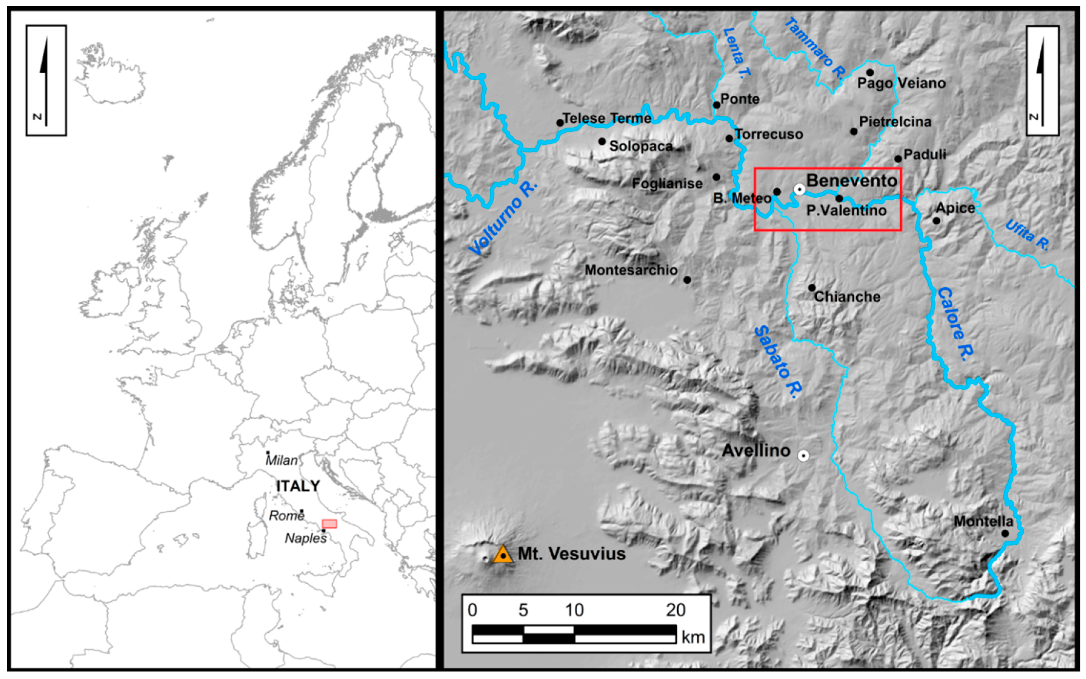
Study Area
2. Materials and Methods
3. Results
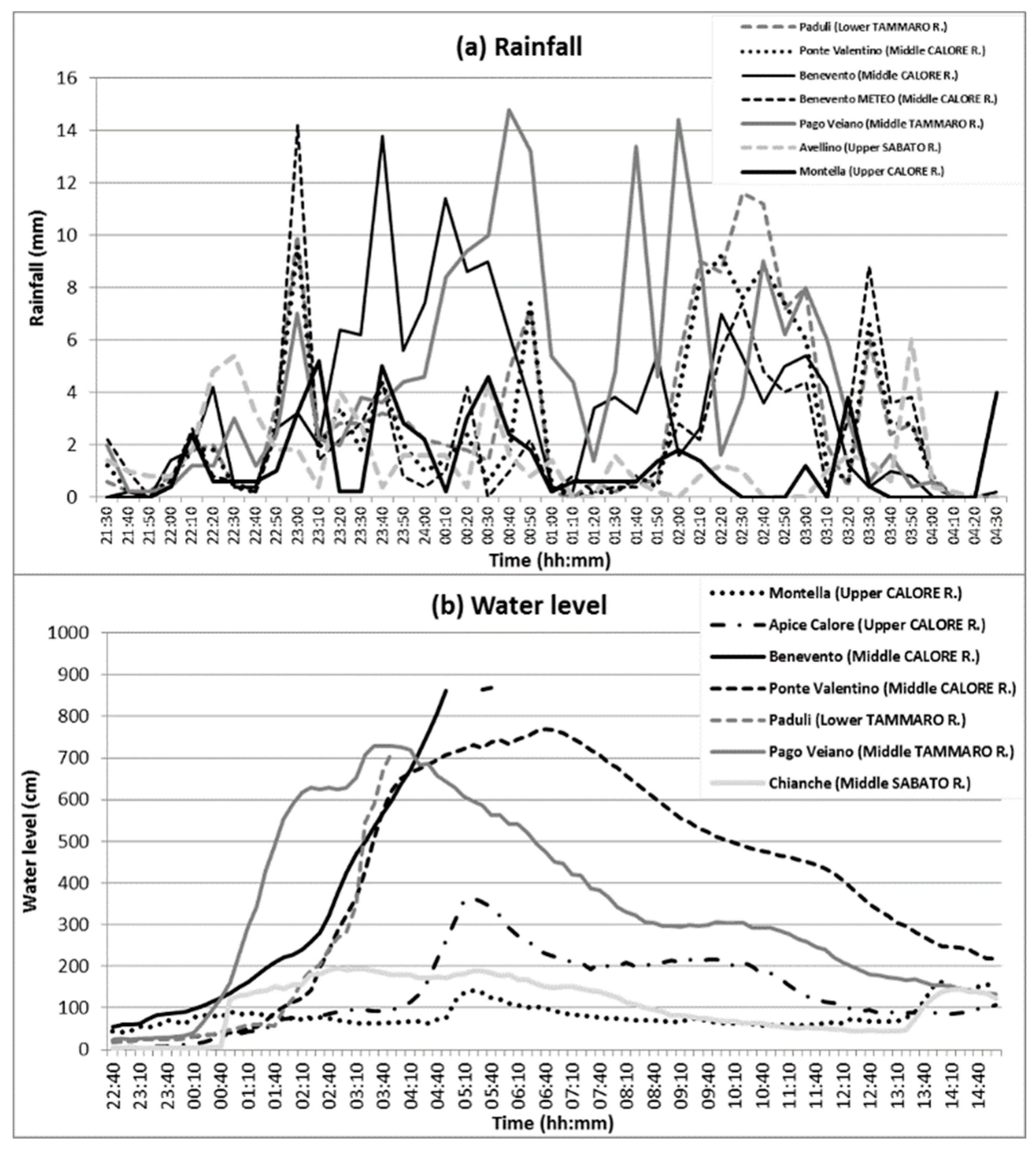
3.1. The 15 October 2015 Event: A Brief Outline
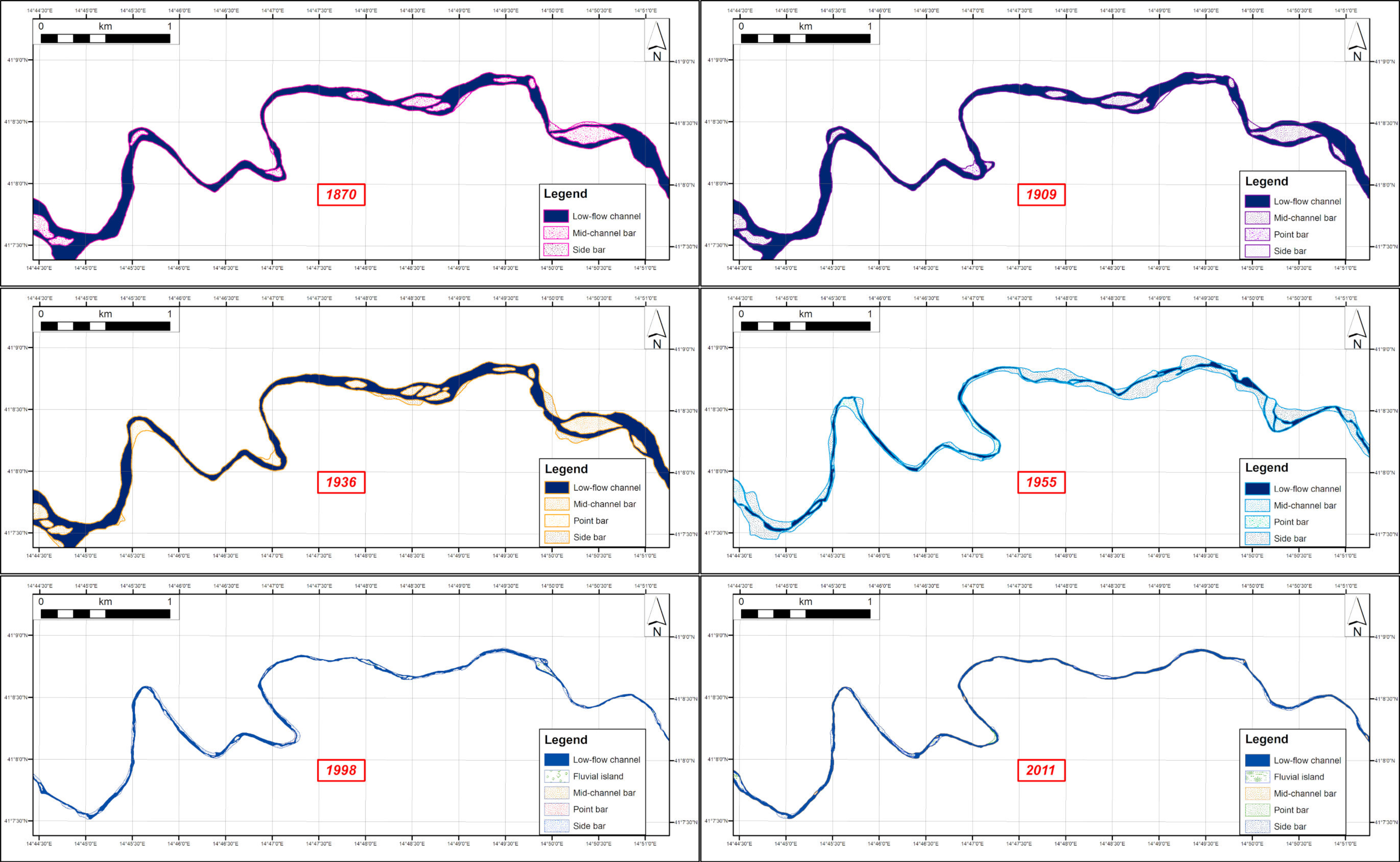
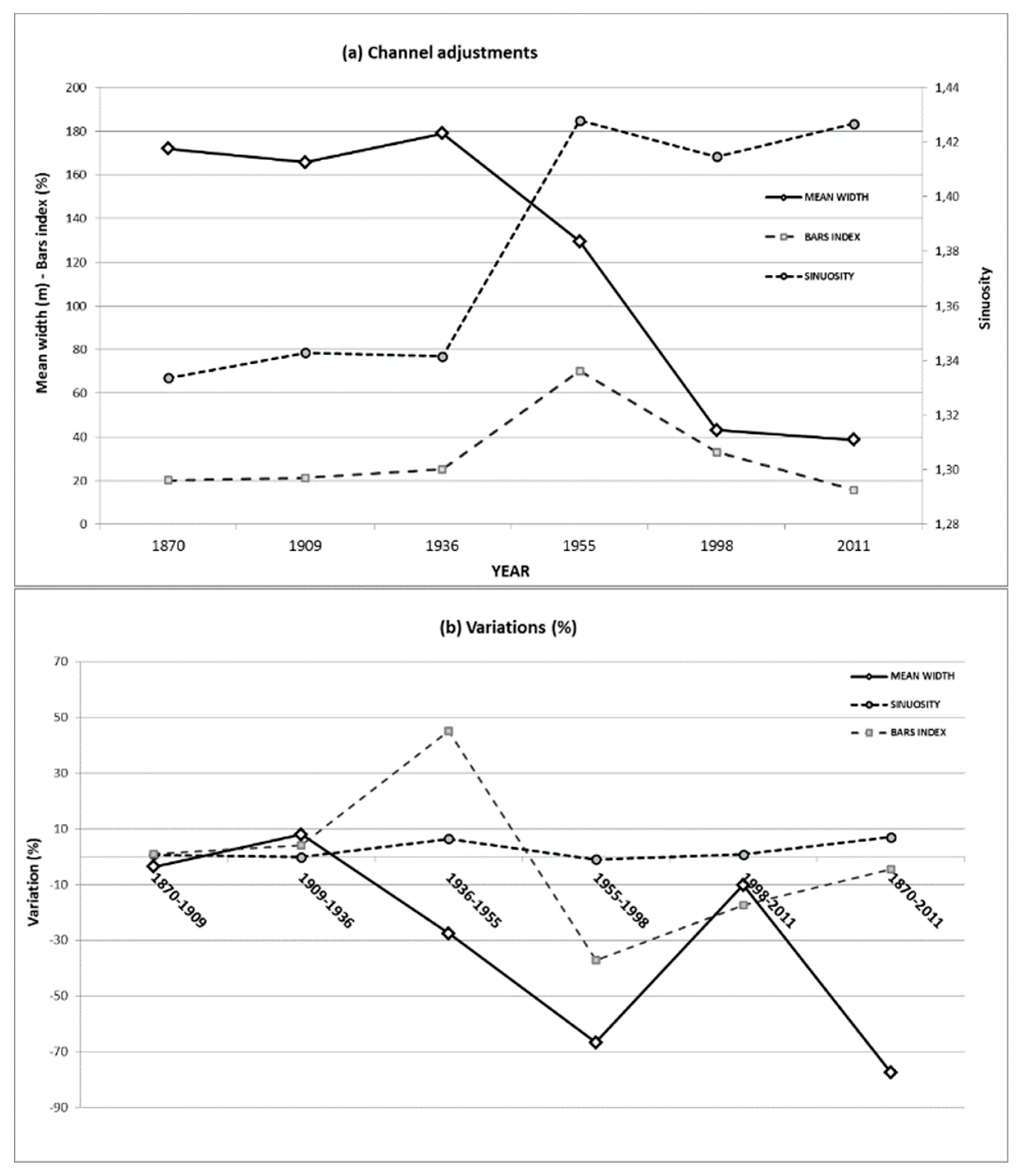
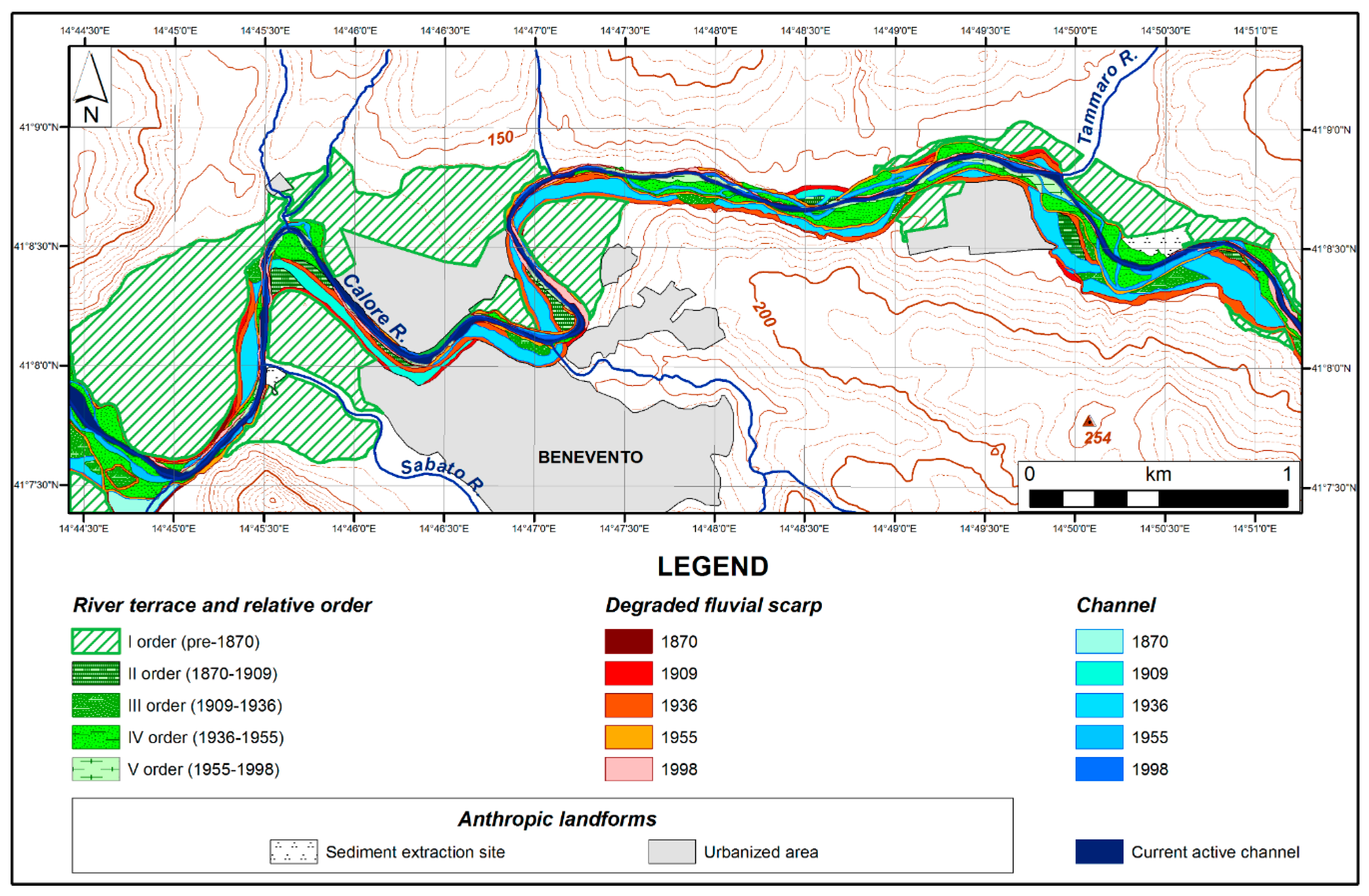
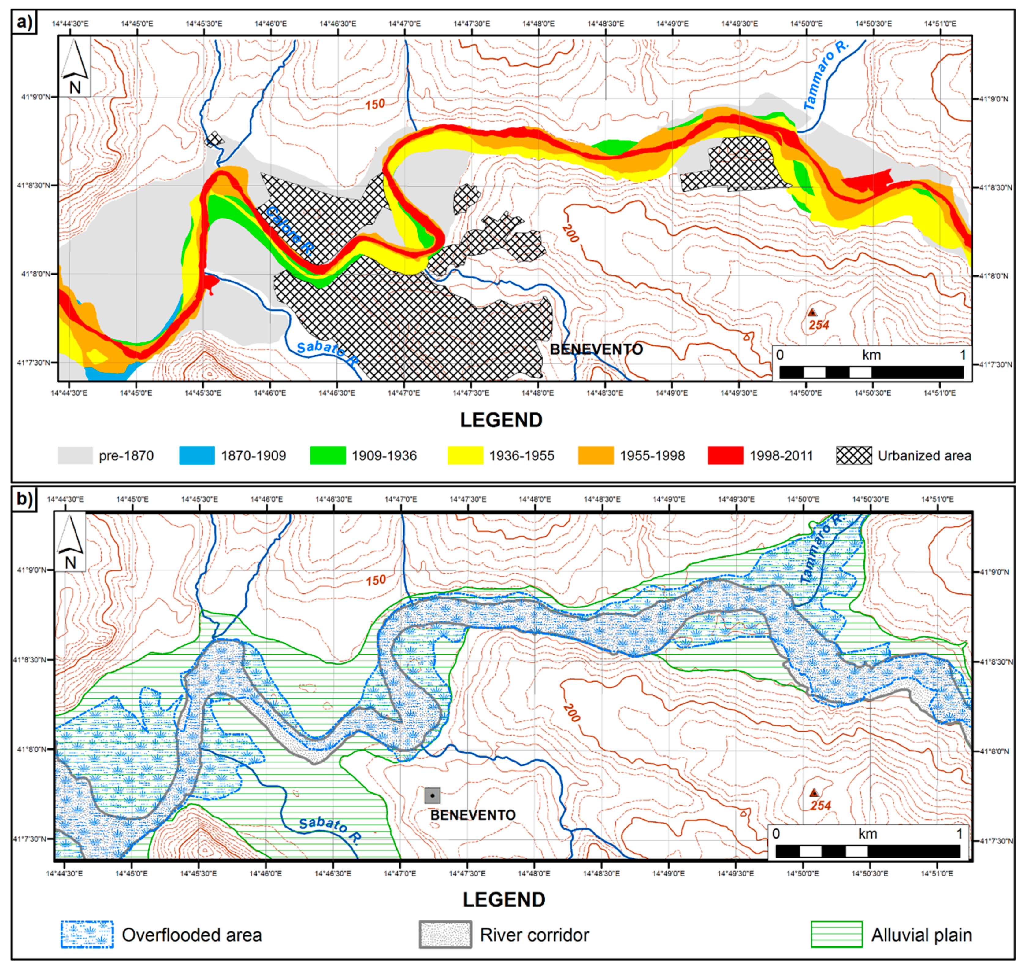
3.2. The GIS-Based Geomorphological Map
4. Discussion
5. Conclusions
Author Contributions
Funding
Acknowledgments
Conflicts of Interest
References
- Vitek, J.D.; Giardino, J.R.; Fitzgerald, J.W. Mapping geomorphology: A journey from paper maps through computer mapping to GIS and virtual reality. Geomorphology 2008, 16, 233–249. [Google Scholar] [CrossRef]
- Bishop, M.P.; Allan James, L.; Shroder, J.F., Jr.; Walsh, S.J. Geospatial technologies and digital geomorphological mapping: Concepts, issues and research. Geomorphology 2012, 137, 5–26. [Google Scholar] [CrossRef]
- Seijmonsbergen, A.C. The modern geomorphological map. In Methods in Geomorphology; Shroder, J., Switzer, A.D., Kennedy, D.M., Eds.; Academic Press: San Diego, CA, USA, 2013; pp. 35–52. [Google Scholar]
- Kamal, A.S.M.M.; Midorikawa, S. GIS-based geomorphological mapping using remote sensing data and supplementary geoinformation: A case study of the Dhaka city area, Bangladesh. Int. J. Appl. Earth Obs. 2004, 6, 111–125. [Google Scholar] [CrossRef]
- Arvor, D.; Durieux, L.; Andrés, S.; Laporte, M.A. Advances in Geographic Object-Based Image Analysis with Ontologies: A review of main contributions and limitations from a Remote Sensing perspective. ISPRS J. Photogramm. 2013, 82, 125–137. [Google Scholar] [CrossRef]
- Chen, G.; Weng, Q.; Hay, G.; He, Y. Geographic bject-based Image Analysis (GEOBIA): Emerging trends and future opportunities. Gisci. Remote Sens. 2018, 55, 159–182. [Google Scholar] [CrossRef]
- Bocco, G.; Mendoza, M.; Velázquez, A. Remote sensing and GIS-based regional geomorphological mapping—A tool for land use planning in developing countries. Geomorphology 2001, 39, 211–219. [Google Scholar] [CrossRef]
- Gurnell, A.M.; Rinaldi, M.; Belletti, B.; Bizzi, S.; Blamauer, B.; Braca, G.; Buijse, A.D.; Bussettini, M.; Camenen, B.; Comiti, F.; et al. A multi-scale hierarchical framework for developing understanding of river behaviour to support river management. Aquat. Sci. 2016, 78, 1–16. [Google Scholar]
- Dramis, F.; Guida, D.; Cestari, A. Nature and aims of geomorphological mapping. In Geomorphological Mapping. Methods and Applications; Smith, M., Paron, P., Griffiths, J.S., Eds.; Elsevier: Amsterdam, The Netherlands, 2011; pp. 39–73. [Google Scholar]
- Otto, J.-C.; Geilhausen, M.; Gustavsson, M. Cartography: Design, symbolization and visualization of geomorphological maps. In Geomorphological Mapping: A Professional Handbook of Techniques and Applications; Smith, M.J., Paron, P., Griffiths, J., Eds.; Elsevier: London, UK, 2011; pp. 253–295. [Google Scholar]
- Smith, M.J.; Paron, P.; Griffiths, J.S. Geomorphological mapping, methods and applications. In Developments in Earth Surface Processes; Shroder, J.F., Jr., Ed.; Elsevier: Oxford, UK, 2011; Volume 15. [Google Scholar]
- Arundel, S.; Sinha, G. Validating the use of object-based image analysis to map commonly recognized landform features in the United States. Cartogr. Geogr. Inf. Sci. 2018, 46, 1–15. [Google Scholar] [CrossRef]
- Burrough, P.A.; Mc Donnell, R.A. Principles of Geographical Information Systems; Oxford University Press: Oxford, UK, 1998; p. 333. [Google Scholar]
- Zinck, J.A. Physiography and Soils. In ITC Lecture Note SOL.4.1; International Institute for Geoinformation Science and Earth Observation (ITC): Enschede, The Netherlands, 1988; p. 156. [Google Scholar]
- Guida, D.; De Pippo, T.; Cestari, A.; Siervo, V.; Valente, A. Applications of the hierarchic GIS-based geomorphological mapping system. In Proceedings of the 3rd AIGEO National Conference, Modena, Italy, 13–18 September 2009. [Google Scholar]
- Cestari, A.; Cuomo, A.; Dramis, F.; Guida, D.; Palmieri, V.; Paron, P.; Siervo, V. Hierarchical, multiscale, objective, oro-hydrography mapping: From continental (Europe) to national level (Italy). In Proceedings of the IAG/AIG International Workshop, Salerno, Italy, 15–19 October 2012. [Google Scholar]
- Guida, D.; Cestari, A.; Cuomo, A.; Dramis, F.; Palmieri, V.; Paron, P.; Siervo, V. The geomorphological informative mapping system of Salerno university: An overview. In Proceedings of the IAG/AIG International Workshop, Salerno, Italy, 15–19 October 2012. [Google Scholar]
- Pipaud, I.; Lehmkuhl, F. Object-based Delineation and classification of alluvial fans by application of mean-shift segmentation and support vector machines. Geomorphology 2017, 293, 178–200. [Google Scholar] [CrossRef]
- Drăgut, L.; Blaschke, T. Automated classification of landform elements using object-based image analysis. Geomorphology 2006, 81, 330–344. [Google Scholar] [CrossRef]
- Asselen, S.V.; Seijmonsbergen, A.C. Expert-driven semi-automated geomorphological mapping for a mountainous area using a laser DTM. Geomorphology 2006, 78, 309–320. [Google Scholar] [CrossRef]
- Camargo, F.F.; Florenzano, T.G.; De Almeida, C.M.; De Oliveira, C.G. Geomorphological mapping using object-based analysis and ASTER DEM in the Parralba do Sul Valley, Brazil. Int. J. Remote Sens. 2009, 30, 6613–6620. [Google Scholar] [CrossRef]
- Gustavsson, M.; Kolstrup, E.; Seijmonsbergen, A.C. A new symbol-and-GIS based detailed geomorphological mapping system: Renewal of a scientific discipline for understanding landscape development. Geomorphology 2006, 77, 90–111. [Google Scholar] [CrossRef]
- Gustavsson, M.; Kolstrup, E. New geomorphological mapping system used at different scales in a Swedish glaciated area. Geomorphology 2009, 110, 37–44. [Google Scholar] [CrossRef]
- Valente, A.; Magliulo, P. A GIS based geomorphological map of the Calore River alluvial plain in Benevento area (Campania, Italy). Rend. Online Soc. Geol. Ital. 2012, 21, 1161–1163. [Google Scholar]
- Magliulo, P.; Cusano, A. Geomorphology of the Lower Calore River alluvial plain (Southern Italy). J. Maps 2016, 12, 1119–1127. [Google Scholar] [CrossRef]
- de Graaff, L.W.S.; De Jong, M.G.G.; Rupke, J.; Verhofstad, J. A geomorphological mapping system at scale 1:10.000 for mountainous areas (Austria). Z. Geomorphol. 1987, 31, 229–242. [Google Scholar]
- Marston, R.A.; Girel, J.; Pautou, G.; Piegay, H.; Bravard, J.P.; Arneson, C. Channel metamorphosis, floodplain disturbance, and vegetation development: Ain River, France. Geomorphology 1995, 13, 121–131. [Google Scholar] [CrossRef]
- Wheaton, J.M.; Fryirs, K.A.; Brierley, G.; Baangen, S.G.; Bouwes, N.; Ó’Brien, G. Geomorphic mapping and taxonomy of fluvial landforms. Geomorphology 2015, 248, 273–295. [Google Scholar] [CrossRef]
- Napieralski, J.; Barr, I.; Kamp, U.; Kervyn, M. Remote sensing and GIS science in geomorphological mapping. In Treatise on Geomorphology; Shroder, J., Bishop, M.P., Eds.; Academic Press: San Diego, CA, USA, 2013; Volume 3, pp. 187–227. [Google Scholar]
- Dal Cin, C.; Moens, L.; Dierickx, P.; Bastin, G.; Zech, Y. An integrated approach for real time flood map forecasting on the Belgian Meuse River. Nat. Hazards 2005, 36, 237–256. [Google Scholar]
- Cook, A.; Merwade, V. Effect of topographic data, geometric configuration and modelling approach on flood inundation mapping. J. Hydrol. 2009, 377, 131–142. [Google Scholar] [CrossRef]
- Van Westen, C.J.; Soeters, R.; Sijmons, K. Digital geomorphological landslide hazard mapping of the Alpago area, Italy. Int. J. Appl. Earth Obs. 2000, 2, 51–60. [Google Scholar] [CrossRef]
- Wohl, E.; Oguchi, T. Geographic information systems and mountain hazards. In Geographic Information Science and Mountain Geomorphology; Bishop, M.P., Shroder, J.F., Eds.; Springer-Praxis: Chichester, UK, 2004; pp. 309–342. [Google Scholar]
- Seijmonsbergen, A.C.; de Graaff, L.W.S. Geomorphological mapping and geophysical profiling for the evaluation of natural hazards in an alpine catchment. Nat. Hazard Earth Sys. 2006, 6, 185–193. [Google Scholar] [CrossRef]
- Meyer, V.; Scheuer, S.; Haase, D. A multicriteria approach for flood risk mapping exemplified at the Mulde River, Germany. Nat. Hazards 2009, 48, 17–39. [Google Scholar] [CrossRef]
- Segura-Beltràn, F.; Sanchis-Ibor, C.; Morales-Hernàndez, M.; Gonzàlez-Sanchis, M.; Bussi, G.; Ortiz, E. Using post-flood surveys and geomorphologic mapping to evaluate hydrological and hydraulic models: The flash-flood of the Girona River (Spain) in 2007. J. Hydrol. 2016, 541, 310–329. [Google Scholar] [CrossRef]
- Borga, M.; Anagnostou, E.N.; Blöschl, G.; Creutin, J.D. Flash-flood forecasting, warning and risk management: The HYDRATE project. Environ. Sci. Policy 2011, 14, 834–844. [Google Scholar] [CrossRef]
- Alcantara-Ayala, I. Geomorphology, natural hazards, vulnerability and prevention of natural disasters in developing countries. Geomorphology 2002, 47, 107–124. [Google Scholar] [CrossRef]
- Langat, P.K.; Kumar, L.; Koech, R. Monitoring river channel dynamics using remote sensing and GIS techniques. Geomorphology 2019, 325, 92–102. [Google Scholar] [CrossRef]
- Ben Khalfallah, C.; Saidi, S. Spatiotemporal floodplain mapping and prediction using HEC-RAS-GIS tools: Case of the Mejerda river, Tunisia. J. Afr. Earth. Sci. 2018, 142, 44–51. [Google Scholar] [CrossRef]
- Guerriero, L.; Focareta, M.; Fusco, G.; Rabuano, R.; Guadagno, F.M.; Revellino, P. Flood hazard of major river segments, Benevento Province, Southern Italy. J. Maps. 2018, 14, 597–606. [Google Scholar] [CrossRef]
- Magliulo, P.; Valente, A.; Cartojan, E. Recent geomorphological changes of the middle and lower Calore River (Campania, Southern Italy). Environ. Earth Sci. 2013, 70, 2785–2805. [Google Scholar] [CrossRef]
- Patacca, E.; Scandone, P. Geology of the Southern Apennines. Boll. Soc. Geol. Ital. 2007, 7, 75–119. [Google Scholar]
- Magliulo, P.; Russo, F.; Valente, A. Tectonic significance of geomorphological features in the Telesina Valley (Campanian Apennines). Ital. J. Geosci. 2007, 126, 397–409. [Google Scholar]
- APAT. APAT Note Illustrative alla Carta Geologica d’Italia alla scala 1:50.000, foglio 432 “Benevento”; Chiocchini, U., Ed.; Agenzia per la Protezione dell’Ambiente e Servizi Tecnici, Dipartimento Difesa Suolo: Firenze, Italy, 2007; p. 126. [Google Scholar]
- D’Argenio, B.; Pescatore, T.S.; Senatore, M.R.; Bisogno, G.; Tocco, G. Effects of natural events on ancient Benevento, Southern Italy. Rend. Acc. Sci. Fis. Nat. Napoli 2002, 69, 13–26. [Google Scholar]
- Ciarcia, S.; Magliulo, P.; Russo, F.; Valente, A. Osservazioni geologiche e geomorfologiche preliminari sul bacino pleistocenico intermontano di Benevento (Appennino Campano). In Evoluzione Geomorfologica di Lungo Termine del Paesaggio nell’Italia Meridionale: Il Contributo delle Università Locali; Rosskopf, C.M., Aucelli, P.P.C., Eds.; Università degli Studi del Molise, Associazione Italiana di Geografia Fisica e Geomorfologia (AIGeo): Ripalimosani, Italy, 2014; pp. 125–141. [Google Scholar]
- CNR-DGCI. Valutazione delle piene in Campania. In Previsione e Prevenzione degli Eventi Idrologici Estremi e Loro Controllo, Linea 1; Rossi, F., Villani, P., Eds.; Consiglio Nazionale delle Ricerche, Gruppo Nazionale per la Difesa dalle Catastrofi Idrogeologiche, Presidenza del Consiglio dei Ministri, Dipartimento della Protezione Civile, Grafica Metelliana & C.: Cava de’ Tirreni, Italy, 1995; p. 310. [Google Scholar]
- Fonseca, A.F.; Zêzere, J.L.; Neves, M. Combining geomorphological mapping and geomorphometry in the study of the Plio-quaternary tectonic geomorphology of the Arrábida Chain (Portugal). In Proceedings of the IAG/AIG International Workshop, Salerno, Italy, 15–19 October 2012. [Google Scholar]
- Surian, N.; Rinaldi, M.; Pellegrini, L. Linee Guida per l’Analisi Geomorfologica degli Alvei Fluviali e delle Loro Tendenze Evolutive; Cleup: Padova, Italy, 2009; p. 79. [Google Scholar]
- Piacentini, T.; Urbano, T.; Sciarra, M.; Schipani, I.; Miccadei, E. Geomorphology of the floodplain at the confluence of the Aventino and Sangro rivers (Abruzzo, Central Italy). J. Maps 2016, 12, 443–461. [Google Scholar] [CrossRef]
- Valente, A.; Iscaro, C.; Magliulo, P.; Russo, F. The flood event in Benevento on 14–15 October 2015: A short report. Rend. Online Soc. Geol. Ital. 2016, 38, 105–108. [Google Scholar]
- Rinaldi, M.; Surian, N.; Comiti, F.; Bussettini, M. A methodological framework for hydromorphological assessment, analysis and monitoring (IDRAIM) aimed at promoting integrated river management. Geomorphology 2015, 251, 122–136. [Google Scholar] [CrossRef]
- European Commission. Directive 2000/60/EC of the European Parliament and of the Council of 23 October 2000 Establishing a Framework for Community Action in the Field of Water Policy. Available online: https://eur-lex.europa.eu/eli/dir/2000/60/oj (accessed on 31 December 2019).
- European Commission. Directive 2007/60/EC of the European Parliament and of the Council of 23 October 2007 on the Assessment and Management of Flood Risks. Available online: https://eur-lex.europa.eu/legal-content/EN/TXT/?uri=celex:32007L0060 (accessed on 31 December 2019).
- Malavoi, J.R.; Bravard, J.P.; Piegay, H.; Herouin, E.; Ramez, P. Determination de l’espace de liberte’ des cours d’eau. In Guide Technique No. 2; Agence de l’Eau Rhône Méditerranée Corse: Lyon, France, 1998; p. 39. [Google Scholar]
- Rapp, C.F.; Abbe, T.B. A framework for delineating channel migration zones. In Ecology Publication #03-06-027; Washington State Department of Ecology and Transportation: Olympia, WA, USA, 2003; p. 135. [Google Scholar]
- Lagasse, P.F.; Zevenbergen, L.V.; Spitz, W.J.; Thorne, C.R. Methodology for Predicting Channel Migration. National Cooperative Highway Research Program, 2004, Web-Only Document, Project 24-16, 67. Available online: http://onlinepubs.trb.org/onlinepubs/nchrp/nchrp_w67.pdf (accessed on 25 November 2019).
- Scorpio, V.; Surian, N.; Cucato, M.; Dai Prá, E.; Zolezzi, G.; Comiti, F. Channel changes of the Adige River (Eastern Italian Alps) over the last 1000 years and identification of the historical fluvial corridor. J. Maps 2018, 14, 680–691. [Google Scholar] [CrossRef]


| Year | Type | Producer | Scale | Scanning Resolution (dpi) | Pixel Size (m) | Positional Error (m) |
|---|---|---|---|---|---|---|
| 1870 | HM | IGMI | 1:50,000 | 300 | 5.4 | 35 |
| 1909 | HM | IGMI | 1:50,000 | 600 | 4.0 | 29 |
| 1936 | HM | IGMI | 1:50,000 | 300 | 5.0 | 31 |
| 1955 | TM | IGMI | 1:25,000 | 1200 | 2.3 | 16 |
| 1998 | O | Campania Region | 1:10,000 | - | 2.0 | 4 |
| 2011 | O | Campania Region | 1:5000 | - | 0.5 | - |
| Station | Latitude Longitude | Total Rainfall (mm) | Mean Rainfall (mm/h) | Intensity Peak (mm/10 min) |
|---|---|---|---|---|
| Benevento | 41.142000 14.762417 | 140.6 | 28.1 | 13.8 |
| Benevento Meteo | 41.115056 14.825028 | 90.8 | 18.2 | 14.2 |
| Ponte Valentino | 41.141667 14.836028 | 107.6 | 21.5 | 9.6 |
| Paduli | 41.148222 14.834806 | 123.6 | 24.7 | 11.6 |
| Pago Veiano | 14.259833 14.897611 | 183.6 | 36.7 | 14.8 |
| Order | Period of Formation | Mean Altitude (m a.s.l.) | No. of Remnants | Total Area (km2) | Terraced Area (%) | Study Area (%) |
|---|---|---|---|---|---|---|
| I | pre-1870 | 125.8 | 13 | 4.17 | 77.1 | 33.6 |
| II | 1870–1909 | 123.6 | 8 | 0.16 | 2.9 | 1.3 |
| III | 1909–1936 | 121.1 | 12 | 0.21 | 3.9 | 1.7 |
| IV | 1936–1955 | 119.1 | 42 | 0.73 | 13.5 | 5.9 |
| V | 1955–1998 | 117.0 | 18 | 0.14 | 2.6 | 1.1 |
© 2020 by the authors. Licensee MDPI, Basel, Switzerland. This article is an open access article distributed under the terms and conditions of the Creative Commons Attribution (CC BY) license (http://creativecommons.org/licenses/by/4.0/).
Share and Cite
Magliulo, P.; Valente, A. GIS-Based Geomorphological Map of the Calore River Floodplain Near Benevento (Southern Italy) Overflooded by the 15th October 2015 Event. Water 2020, 12, 148. https://doi.org/10.3390/w12010148
Magliulo P, Valente A. GIS-Based Geomorphological Map of the Calore River Floodplain Near Benevento (Southern Italy) Overflooded by the 15th October 2015 Event. Water. 2020; 12(1):148. https://doi.org/10.3390/w12010148
Chicago/Turabian StyleMagliulo, Paolo, and Alessio Valente. 2020. "GIS-Based Geomorphological Map of the Calore River Floodplain Near Benevento (Southern Italy) Overflooded by the 15th October 2015 Event" Water 12, no. 1: 148. https://doi.org/10.3390/w12010148
APA StyleMagliulo, P., & Valente, A. (2020). GIS-Based Geomorphological Map of the Calore River Floodplain Near Benevento (Southern Italy) Overflooded by the 15th October 2015 Event. Water, 12(1), 148. https://doi.org/10.3390/w12010148