Article

Managed Aquifer Recharge as a Strategic Storage and Urban Water Management Tool in Darwin, Northern Territory, Australia

1
CloudGMS Pty Ltd. 3 Wright Street, Edwardstown, Adelaide SA 5039, Australia
2
CSIRO Land and Water Waite Laboratories, Waite Rd, Urrbrae, Adelaide SA 5064, Australia
3
CSIRO Land and Water, Private Mail Bag 44, Winnellie, Darwin, NT 0822, Australia
4
CSIRO Land and Water, College Road, University of Tasmania, Sandy Bay, Hobart 7005, Australia
*
Author to whom correspondence should be addressed.
Water 2019, 11(9), 1869; https://doi.org/10.3390/w11091869
Submission received: 24 June 2019 / Revised: 3 September 2019 / Accepted: 5 September 2019 / Published: 9 September 2019
(This article belongs to the Special Issue Managed Aquifer Recharge for Water Resilience)

Abstract

:
Population growth and increased irrigation demand have caused a decline in groundwater levels that limit water supply in the Darwin rural area. Managed Aquifer Recharge (MAR) is a practical solution that can be adopted to augment stressed groundwater systems and subsequently increase the security of water supply. Aquifer storage capacity is considered to be the primary constraint to MAR where unconfined dolostone aquifers rapidly recharge during the tropical, wet season and drain again in the dry season. As a result, there is a general understanding that aquifers of this nature recharge to full capacity each wet season. However, the aquifer storage capacity and the potential for niche opportunities for MAR to alleviate declining groundwater levels has not previously been examined. This paper uses the Darwin rural area’s Proterozoic Koolpinyah Dolostone aquifer and the existing Koolpinyah Groundwater System to evaluate the prospects of MAR using both infiltration and injection techniques. Direct injection wells in an aquifer storage transfer and recovery (ASTR) scheme were favoured in this area, as injection wells occupy a smaller surface footprint than infiltration basins. This assessment suggested MAR during the early to mid-dry season could alleviate the impact of the dry season decline in groundwater levels in the Darwin rural area. The use of a larger aquifer storage and recovery (ASR) system (5,000,000 m3/year) was also assessed as a potentially viable technical solution in the northern part of the aquifer where it is understood to be confined. The ASR scheme could potentially be scaleable to augment the urban water system and provide strategic long-term storage. Consideration must also be given not only to the strategic positioning of the ASR water bank, but also to the hydrogeology of the aquifers in which the systems would be developed. Not all locations or aquifer systems can successfully support a strategic storage ASR system. Scheme-scale feasibility assessment of an ASR water bank is required. The study reported here is an early phase of a series of investigations that would typically be required to demonstrate the viability of any proposal to apply MAR to increase the reliability of conjunctive groundwater and surface water supplies in stressed water resources systems. It focusses on assessing suitable storage areas in a lateritic aquifer.

1. Introduction

Urban potable water supply systems require a high degree of reliability and security. This can be challenging where rainfall is seasonal such as in the vicinity of the city of Darwin, Northern Territory, Australia. Darwin experiences distinct wet and dry seasons, with 95% of rain falling in the wet-season months (November to April). The annual average rainfall is 1423 mm.
Darwin’s reticulated water network has traditionally relied upon surface water reservoirs with a minor component (~15%) from groundwater [1]. Borefields used for urban water supply are in the peri-urban Darwin rural area and target the Koolpinyah Dolostone aquifer [2]. Reticulated water demand by urban and industrial users has produced an immediate system yield shortfall of approximately 5,000,000 m3/year [1]. Locally, the water from this dolostone aquifer is also relied upon heavily for drinking and irrigation as the Darwin rural area is not connected to reticulated water supply. A consequence of this is that the residents of the Darwin rural area are particularly vulnerable to consecutive years of poor rainfall.
In 2016, the groundwater levels for the most part were low if not the lowest recorded for the past ten years for most of the Darwin rural area in the vicinity of the municipal borefield area (Figure 1). End of dry-season water levels can result in risk to the water supply for many groundwater users in this area and to nearby groundwater dependent ecosystems, such as Howard Springs. Figure 1b shows that the dry season groundwater levels approach the level at which Howard Springs reportedly ceases to flow [1,3]. MAR has been put forward as an option to help augment the stressed groundwater resource in the Darwin rural area. Previously, the potential for MAR in this area has been dismissed [4] without any technical assessment of viability using available data.
This study investigates the potential for managed aquifer recharge (MAR) to: (i) reduce the risk of water stress for residents in the Darwin Rural Area; and (ii) provide addition storage capacity for reticulated supplies for urban and industrial use in Darwin. It examines how the options can interact to provide urban water supply security for the Darwin rural area and the potential for the development of a strategic storage for the City of Darwin. Specifically, it considers the potential for MAR into the most water stressed parts of the Koolpinyah Dolostone aquifer (e.g., MAR1-5 in Figure 2).
Both the augmentation of the Darwin rural peri-urban system and a strategic ASR scheme are favoured in an aquifer that has generally high hydraulic conductivity, low specific yields, a suitably large volume of unsaturated sediments, natural boundaries that limit vertical and horizontal losses of the stored water, and low salinity of the native groundwater. For the ASR scheme to be successful, the hydraulic conductivity of the storage aquifer must be high to allow high rates of infiltration or injection over a relatively short wet season period as well as enabling high rates of extraction of the stored water to meet urban requirements.
The general understanding is that unconfined aquifers in the Darwin catchments rapidly recharge to full capacity during the wet season and drain again in the dry season [4], a common occurrence in unconfined, shallow aquifers. Aquifer storage capacity in the wet season, when there is access to a source of water for recharge, is considered to be the primary constraint to replenishing these unconfined aquifers via MAR [5]. However, the aquifer storage capacity of the Koolpinyah Dolostone and the potential for MAR have not previously been examined. This study addresses this knowledge gap by considering niche opportunities for MAR, by assessing the additional volume of water that could be recharged to alleviate the impact of current pumping for urban water supply, rural residential use and horticultural water supply. This study can be considered as a pre-feasibility assessment using available information and has the following objectives:
  • Can MAR be used to reduce the groundwater stress (reduce the decline in groundwater levels during the dry season) in the Darwin rural area?
  • Which MAR type is most effective (i.e., infiltration or injection)?
  • Is there potential for well injection in the confined part of the aquifer for a strategic urban storage during the wet season?
Available surface water is assumed to be the source of water for recharge. The current Darwin Regional Water Supply Strategy does not address the vulnerability of water supply in the Darwin rural area [1]. Instead, it focuses on diversifying supply options to increase security and sustainability of supply to the Greater Darwin Region. Therefore, this paper is the first investigation of the potential to apply MAR to increase the reliability of conjunctive groundwater and surface water supplies in the rural area, a seasonally stressed water resource. However, the detailed technical, social and economic feasibility of specific MAR configurations is not addressed. The Australian MAR Guidelines [6] provide a comprehensive risk-based framework for assessment of scheme-scale technical feasibility, addressing human health and environmental risks along with operational issues such as clogging.

2. Methodology

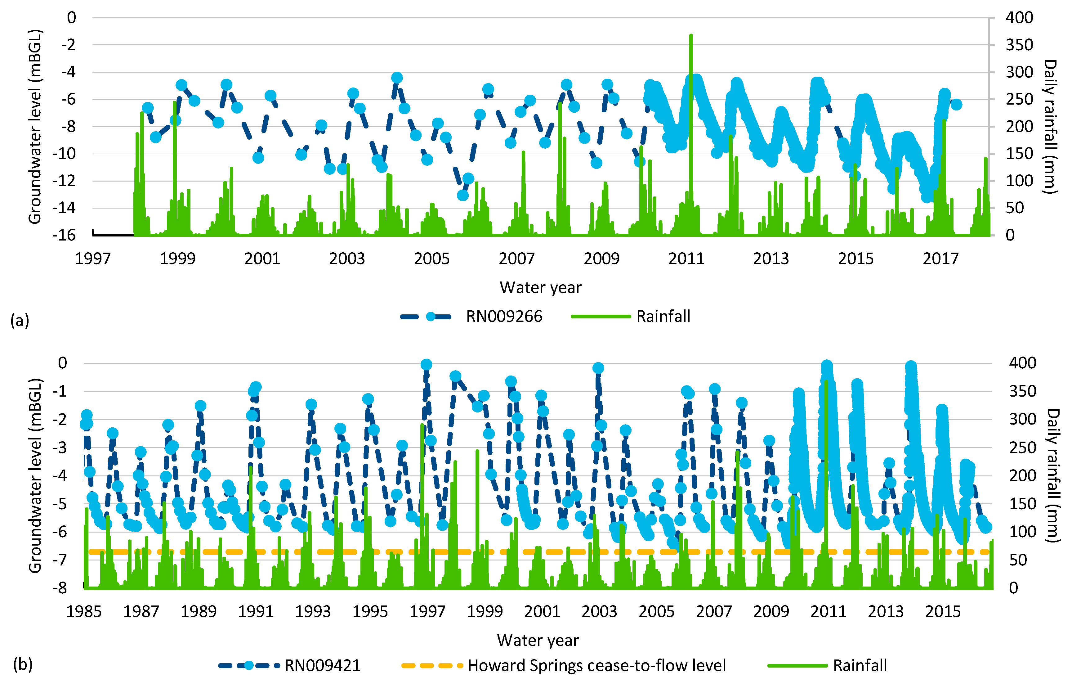
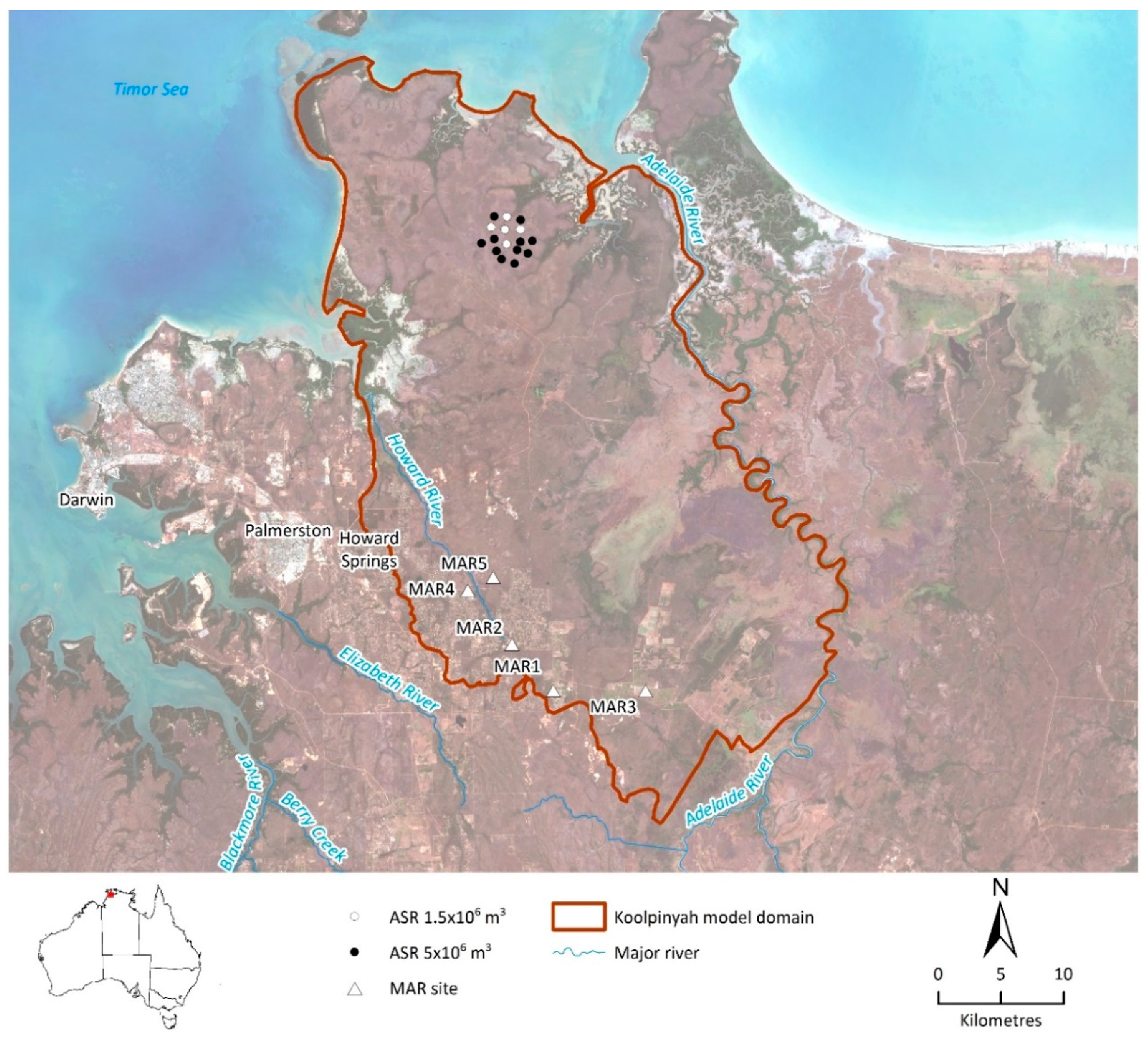
2.1. Koolpinyah Groundwater System Model

The Northern Territory Government’s Koolpinyah Groundwater System model was used to investigate the potential for MAR in the Koolpinyah Dolostone (i) to augment seasonally declining groundwater levels to prevent private water supply bores failing during the dry season and (ii) to provide a larger, potentially long-term strategic storage for urban water supply. The Koolpinyah Dolostone is largely unconfined in the stressed areas where augmentation is assessed, while to the north it is confined by mudstone.
The current Koolpinyah Groundwater System model was developed using the FEFLOW code. The model is fully described by CloudGMS [2]. The model domain covers approximately 1600 km2, including the Howard River catchment and the western part of the Adelaide River catchment and includes the extent of the Koolpinyah Dolomite based on the interpretation of airborne magnetics and electromagnetic data [2]. It comprises three layers: layer 1 (the upper layer) represents the laterite aquifer, layer 2 represents the Cretaceous sediments within the weathered dolomite and layer 3 represents the fractured zone of the Koolpinyah Dolomite. The Koolpinyah Groundwater System model was calibrated on groundwater levels and dry season discharge measurements, over the period from 1980 to 2014, using the automated inversion software PEST [2]. Extraction volumes are uncertain, as rural residential water use is not metered.
The model is reported to be Category 2, with the capacity to achieve Category 3, according the Australian Groundwater Modelling Guidelines [7], due to a reasonably long observation data set over the areas with greatest stress and since projected pumping scenarios have stresses similar in magnitude.
There are five types of boundary conditions in the model:
  • No-flow boundaries around the western and southern portions of the model domain and at the bottom of layer 3. No-flow boundaries to the south-west represent the presence of low permeability basement rocks that would impede radial flow and increase mounding. It is acknowledged that the proximity of the area of interest (stressed areas) to the no-flow boundary may impact on simulation results.
  • Constant head (Dirichlet) boundary conditions representing spring discharge from the dolostone.
  • Seepage surface boundary conditions at the ground surface.
  • Transfer (Cauchy) boundary conditions representing the fluxes at the coast and Adelaide River.
  • Well boundary conditions to represent groundwater withdrawal.

2.2. Modelling Scenarios for Peri-Urban Groundwater Augmentation and a Strategic Storage

The modelling scenarios to consider the potential for MAR in this rural area were simulated over the period 1996 to 2014 and focused on five stressed locations selected for recharge augmentation: MAR1 to MAR5 (Figure 2). Infiltration (SC1a) and injection (SC1b, SC2a) techniques were both assessed. At MAR1–MAR5, the Koolpinyah Dolostone is unconfined, and hydraulic heads were used to trigger and halt the enhanced recharge under these scenarios.
A key constraint for inter-seasonal recharge is securing a source of water during the dry season when the storage capacity becomes available in the aquifer. Therefore, the potential of a scheme to store water in the wet season, when it is likely to be available, was investigated. For this purpose, a strategic water bank formed with an ASR wellfield (SC1c, SC2b) was simulated to the north of the drawdown area (Figure 2) where the aquifer is understood to be confined (Figure 2). Each MAR scenario was compared to the base case (without MAR). Modelling scenarios are summarised in Table 1 and described in the following text.
In the stressed area, the first stage of modelling assessed the feasibility and type of MAR during the dry season (SC1a and SC1b, mid dry season). Hydraulic heads at a point in the centre of the MAR sites were used to trigger recharge augmentation, via using either infiltration basins or injection wells (Aquifer Storage Transfer Recovery (ASTR)). Trigger values were set equal to the observed end of dry season (30 November 2009) hydraulic head without MAR (MAR1, 2, 4 and 5~18 mAHD; MAR3~10 mAHD). A node spacing was allowed between recharge (MAR) and recovery locations (existing bores) to reduce interference.
The second stage of modelling considered the potential for MAR via injection (ASTR) with injection commencing at the start of the dry season for approximately three months until the start of July at MAR1 and MAR3 (SC2a, early dry season). A constant head was maintained from 1 April (or when heads declined below the trigger) to 1 July (MAR1 constant head of 36 mAHD applied, MAR3 constant head of 20 mAHD applied). Importantly, this scenario removed pumping from town water supply bores to assess the potential benefits to the stressed areas of using the strategic ASR water bank for town water supply.
In the assessment of the ASR water bank, the first stage of modelling considered 1,500,000 m3/year of injection and recovery (SC1c) (5 ASR bores, 27.4 m3/day per bore for 120 days). The ASR water bank scenario was developed further in the second stage of modelling (SC2b), with a 5,000,000 m3/year water bank (16 SR bores, 27.4 m3/day per bore for 120 days) replacing extraction for town water supply in the stressed area.

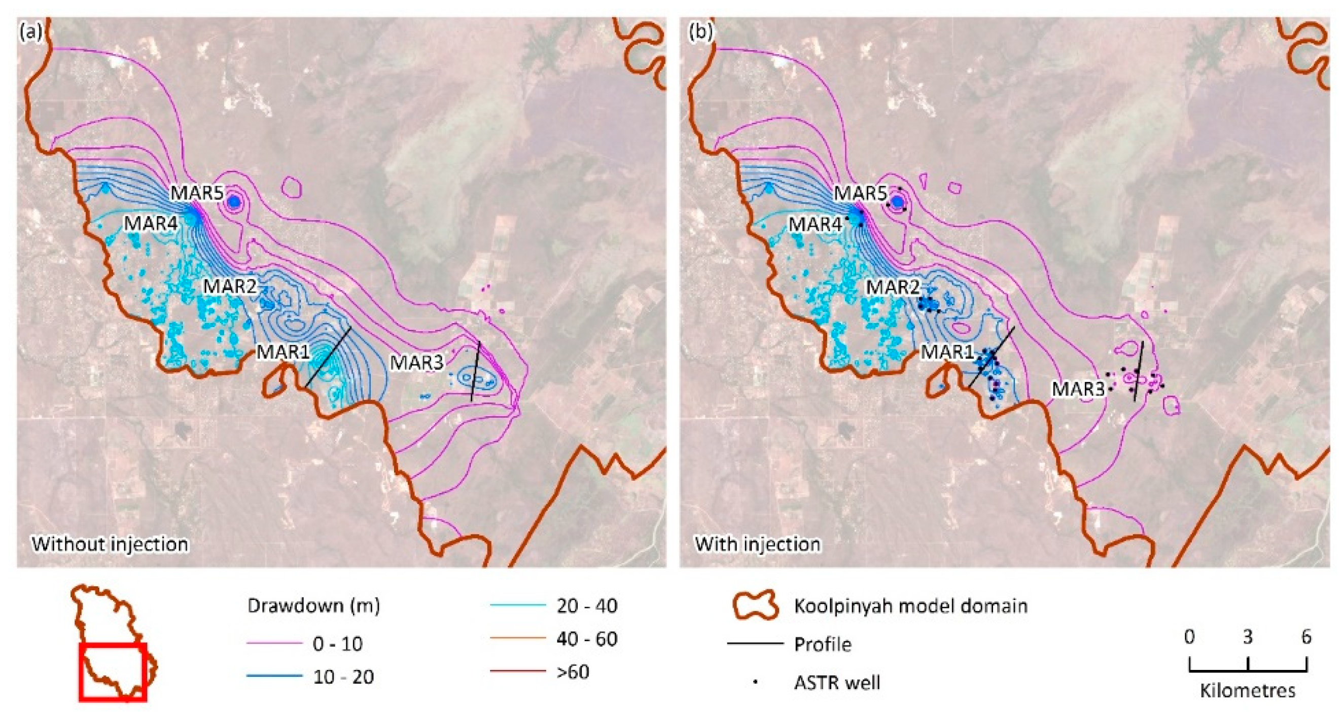
3. Results and Discussion

This first stage of modelling was used to determine if MAR recharge via infiltration or injection was more feasible for this area. The opportunity to create a strategic ASR water bank further to the north in the confined part of the aquifer was also investigated.
Both infiltration and injection modelling scenarios in the stressed areas were limited by the established model construction and scale. In areas where the cone of depression was not well represented, the node spacing between recharge and recovery locations resulted in limited instances where recharge was triggered in areas MAR2, 4 and 5. Recharge was triggered at MAR1 and MAR3 (Figure 3) and both techniques achieved a comparable gain in groundwater level when recharge was triggered (Figure 4).
The end of dry-season hydraulic head within a currently stressed area can clearly be increased by MAR (Figure 5, e.g., for injection). At MAR1, the impact on end of dry-season water table was up to 8 m when recharge was applied midway through the dry season and ~2 m when applied at the start of the wet season (Figure 4). The results for MAR3 indicate that infiltration basins and injection wells applying recharge midway through the dry season could cause the water table to rise by ~10 to 15 m at the end of the dry season (Figure 4). Injection at the start of the dry season resulted in an approximately 6 m increase over the base case in end of dry-season water table (Figure 4). However, further assessment is required of the potential for any rise in hydraulic head at the end of the dry season to protect against bores running dry remains.
Overall, the injection (ASTR) method was considered more prospective than infiltration due to fewer land use constraints. In the infiltration scenarios, an infiltration rate of 0.015 m/d was adopted to prevent excessing mounding, which resulted in heads approaching the surface and the invoked seepage face boundary conditions. The properties assigned to layer 1, representing the surficial laterite layer, could allow higher infiltrations fluxes; however, the lower permeability of layer 2 impedes vertical groundwater movement and results in excessive mounding. With a low infiltration rate (<0.02 m/d) a large area of land (>100 ha) would be required for infiltration basins. Land availability for infiltration basins is influenced by land use, which may be achievable in areas with larger block sizes, but areas to the west may not be as prospective due to basin area relative to block sizes.
In the mid-dry season MAR scenarios, most of the augmented recharge was typically triggered between August and December each year. This interval coincides with the period of highest rural residential groundwater use (June to December) when surface water is in high demand for reticulated supply. Despite this competition for water, the volume of recharge required for the inter-seasonal MAR is small (i.e., 1–5,000,000 m3/year), and therefore is unlikely to have a significant impact on the volume of water in surface storage.
The potential for recharge at the start of the dry season was assessed in the second stage of modelling, through application of a constant head from the end of the wet season to the start of July (Table 1). Recharge was typically triggered for 3 months and the median recharge over the simulation period was 1,200,000 m3/year. The magnitude of the increase in hydraulic head at the end of the dry season was less than for the mid-dry season recharge scenario due to the time interval that recharge was triggered in, but presumably having an impact over a larger area. End of dry season hydraulic head declines suggest that sufficient storage remains available for wet-season recharge.
Maintaining hydraulic heads at the start of the dry season may be more practical and economical than waiting until later in the dry season when surface water resources are likely to be stressed and may not be available for MAR. Proximity to groundwater discharge locations would need to be assessed if this option was to be considered in more detail, to ensure the additional recharge is maintained within the aquifer. The scenarios considered indicate a reduction in the dry-season hydraulic head declines; however, the effectiveness of MAR in providing protection to individual groundwater users would need to take bore construction details into account. Infrastructure from the recharge source to recharge locations would also be required.
The ASR water bank scenario recharged a confined portion of the aquifer in the wet season and the model results suggest that the injected water remained localised (<2 km from the ASR bore) to the ASR borefield. With 1,500,000 m3/year of injection and recovery, hydraulic head increased by ~10 m at the end of the wet season and declined by ~5 m at the end of the dry season, when compared to the base case without MAR. Increasing this to 5,000,000 m3/year of injection and recovery, hydraulic head increased by ~20 m at the end of the wet season and declined by ~10 m at the end of the dry season, in relation to the base case.
The potential for development of a 5,000,000 m3/year water bank to replace extraction for municipal supply in the stressed area of the Koolpinyah Dolostone was considered. The cessation of pumping from the municipal supply bores alone provided only localised benefits that did not alleviate groundwater declines in all of the five MAR locations assessed, due to multiple uses (irrigation, rural residential). The MAR water banking approach could serve as a longer-term option for urban water cycle resilience against reduced recharge during poor wet seasons. While the end user has not been defined, it is possible that the ASR water bank could contribute to Darwin urban water supply. Infrastructure from the recharge source to the ASR site and from the ASR site to the end user would be required. This approach is of broad international interest as it demonstrates that there is potential niche application of MAR in lateritic aquifers that have been previously dismissed as unsuitable for MAR. The study demonstrates that there may be opportunities to develop strategic urban water supplies in aquifers, though further investigations would be required to develop a specific scheme.
MAR scheme numerical modelling is typically undertaken at local (scheme) scale of a few kilometres, rather than the regional scale (10s to 100s of kilometres) of the Koolpinyah Groundwater System model. Due to the scale of the existing model, its discretization and the proximity of the stressed areas to the no-flow boundary, it is not possible to evaluate the hydraulic impact of individual MAR schemes. Nonetheless, this regional scale model was sufficient to undertake an entry-level assessment of MAR feasibility.
This pre-feasibility assessment suggests MAR may be beneficial in the Darwin rural area; however, scheme-scale feasibility assessment of an ASR water bank is required. The Australian MAR Guidelines [6] provide a comprehensive risk-based framework for assessment of scheme-scale technical feasibility, addressing human health and environmental risks along with operational issues such as clogging. Regardless of MAR technique, it is necessary to assess the risk of clogging due to recharge water quality and how this can be managed to ensure a sustainable operation.
This study is innovative, as the general area proposed for an ASR water bank has very little existing groundwater use or hydrogeological data. This is a common theme to many Mar investigations and at times may lead to pre-mature dismissal of MAR opportunities in aquifer such as these. Nevertheless, it will be essential to confirm the degree of confinement and the hydraulic response to MAR, the water quality within the storage zone and its potential impact on the utility of recovered water for urban supply and measures to minimize the impact of well clogging. In addition to MAR technical feasibility, it is essential to consider solutions which are supported by the community and are economically viable. Considerable investment in infrastructure would be required for MAR to alleviate stress across multiple areas in the Darwin rural area. However, a combined approach, with actions such as demand management and well maintenance, may prove to be lower cost than alternative water supply strategies.

4. Conclusions

Through this MAR modelling assessment, it was concluded that MAR (by a variety of means) is technically feasible to augment recharge and reduce the magnitude of groundwater decline in the Darwin rural area. Recharge via direct injection may be favoured due to having a smaller surface footprint, particularly in the more urbanised areas. The availability of a source of water for recharge during the dry season was considered a potential constraint for MAR. However, the volume of recharge required for the inter-seasonal MAR is small (i.e., 1-5,000,000 m3/year), and therefore is unlikely to have a significant impact on the volume of water in surface storage. Of particular interest internationally is that this study identified an opportunity for a strategic water bank of 5,000,000 m3/year using ASR wells to the north of the stressed area is another option to augment groundwater resources, storing wet-season excess surface water in the confined part of the aquifer for use when needed.
This pre-feasibility assessment suggests MAR may be beneficial in lateritic aquifers such as the Darwin rural area and that this assessment could be of broader interest in evaluating lateritic aquifers that have typically been deemed unsuitable for MAR.

Author Contributions

A.K. developed the groundwater model, applied the groundwater model to this investigation and contributed to paper writing. D.P. and J.V. conceived the MAR investigation and contributed to paper writing. D.G., K.B., N.H. contributed to data analysis and paper writing. A.T., C.C., C.P. provided oversight of the project and contributed to paper writing.

Funding

This research was funded by Australian Department of Agriculture grant number [22668] and is part of the CSIRO Northern Australia Water Resource Assessment, part of the National Water Infrastructure Development Fund: Water Resource Assessments.

Acknowledgments

This research was undertaken within the Northern Australia Water Resource Assessment as part of the Australian Government’s Agricultural Competitiveness White Paper, the government’s plan for stronger farmers and a stronger economy and was supported by the Department of Agriculture and Water Resources. The authors acknowledge the contributions of Des Yin Foo, Dale Cobban and Mardi Miles (Department of Environment and Natural Resources, NT); and David George, Shane Papworth, Trevor Durling (Power and Water Corporation). The authors gratefully acknowledge the thoughtful review comments of three anonymous reviewers and Peter Dillon, academic editor, in improving the quality of this paper.

Conflicts of Interest

The authors declare no conflict of interest.

References

  1. Power and Water Corporation. Darwin Region Water Supply Strategy; Power and Water Corporation: Darwin, Australia, 2013. [Google Scholar]
  2. CloudGMS. Koolpinyah Groundwater System Groundwater Flow Model Update 1.0.; Prepared for DLRM; CloudGMS: Adelaide, Australia, 2017. [Google Scholar]
  3. Fell-Smith, S.A.; Sumner, J. Technical Report—Koolpinyah Dolomite Aquifer Characteristics Project; Department of Land Resource Management. Water Resources Branch: Darwin, Australia, 2011. [Google Scholar]
  4. Cresswell, R.; Harrington, G.; Hodgen, M.; Li, L.; Petheram, C.; Buettikofer, H.; Davies, P. Water Resource in Northern Australia; CSIRO: Canberra, Australia, 2009. [Google Scholar]
  5. Vanderzalm, J.; Page, D.; Gonzalez, D.; Barry, K.; Dillon, P.; Taylor, A.; Dawes, W.; Cui, T.; Knapton, A. Assessment of Managed Aquifer Recharge (MAR) Opportunities in the Fitzroy, Darwin and Mitchell Catchments; A Technical Report to the Australian Government from the CSIRO Northern Australia Water Resource Assessment, Part of the National Water Infrastructure Development Fund: Water Resource Assessments; CSIRO: Canberra, Australia, 2018. [Google Scholar]
  6. NRMMC-EPHC-NHMRC. Australian Guidelines for Water Recycling: Managed Aquifer Recharge; National Water Quality Management Strategy Document No. 24; Natural Resource Management Ministerial Council, Environmental Protection and Heritage Council, National Health and Medical Research Council: Canberra, Australia, 2009. [Google Scholar]
  7. Barnett, B.; Townley, L.R.; Post, V.; Evans, R.E.; Hunt, R.J.; Peeters, L.; Richardson, S.; Werner, A.D.; Knapton, A.; Boronkay, A. Australian Groundwater Modelling Guidelines; National Water Commission: Canberra, Australia, 2012. [Google Scholar]
Figure 1. Hydrographs of bores in the Darwin rural area: (a) RN009266 at Middle Point and (b) RN009421 at Howard Springs.
Water 11 01869 g001
Figure 2. Location of modelling scenarios: Infiltration basin and well injection scenarios where aquifer is unconfined at MAR1-5; ASR Water bank scenarios where aquifer is confined in the northern section. White and black circles indicate a prospective location for a strategic ASR water bank (1.5 and 5 Mm3/year). MAR scenarios are described in detail in Table 1.
Water 11 01869 g002
Figure 3. Comparison of monthly modelled recharge volume under infiltration (SC1a) or injection (SC1b, SC2a) type MAR scenarios: SC1a and SC1 b recharge occurs during mid-dry season, recharge triggered by dry season minimum hydraulic head of MAR1~18 mAHD, MAR3~10 mAHD. SC2a recharge occurs early dry season, constant head maintained from 1 April to 1 July, MAR1 constant head of 36 mAHD, MAR3 constant head of 20 m AHD.
Water 11 01869 g003
Figure 4. Example cross-section of hydraulic head response under infiltration (SC1a) or injection (SC1b, SC2a) type MAR scenarios at (a) MAR1 and (b) MAR3 for end of dry season groundwater level (30 November 2009). SC1a and SC1b Recharge occurs during the mid-dry season, recharge triggered by dry season minimum groundwater level of MAR1~18 mAHD, MAR3~10 mAHD. SC2a Recharge occurs in the early dry season, with constant groundwater level maintained from 1 April to 1 July, MAR1 constant head of 36 mAHD, MAR3 constant head of 20 mAHD. Location of the cross-section is shown on Figure 5.
Water 11 01869 g004
Figure 5. Hydraulic head response to an ASTR (injection well) MAR scheme (SC1b) triggered by declining hydraulic heads. Recharge is typically triggered between August and December. (a) The base case without MAR and (b) with the effect with MAR.
Water 11 01869 g005
Table 1. Howard East modelling scenarios.
Modelling ScenarioDescriptionSummary of Key Results
Base CaseBase case without MAR, simulated 1996–2014
Groundwater contours on 30 November 2009 (end of dry season) used for comparison to MAR scenarios
Base case groundwater levels on 30 November 2009 were used to set trigger values for MAR scenarios
MAR scenarios, detailed below:MAR scenarios, simulated 1996–2014
Groundwater contours 30 November 2009 (end of dry season) compared to the base case
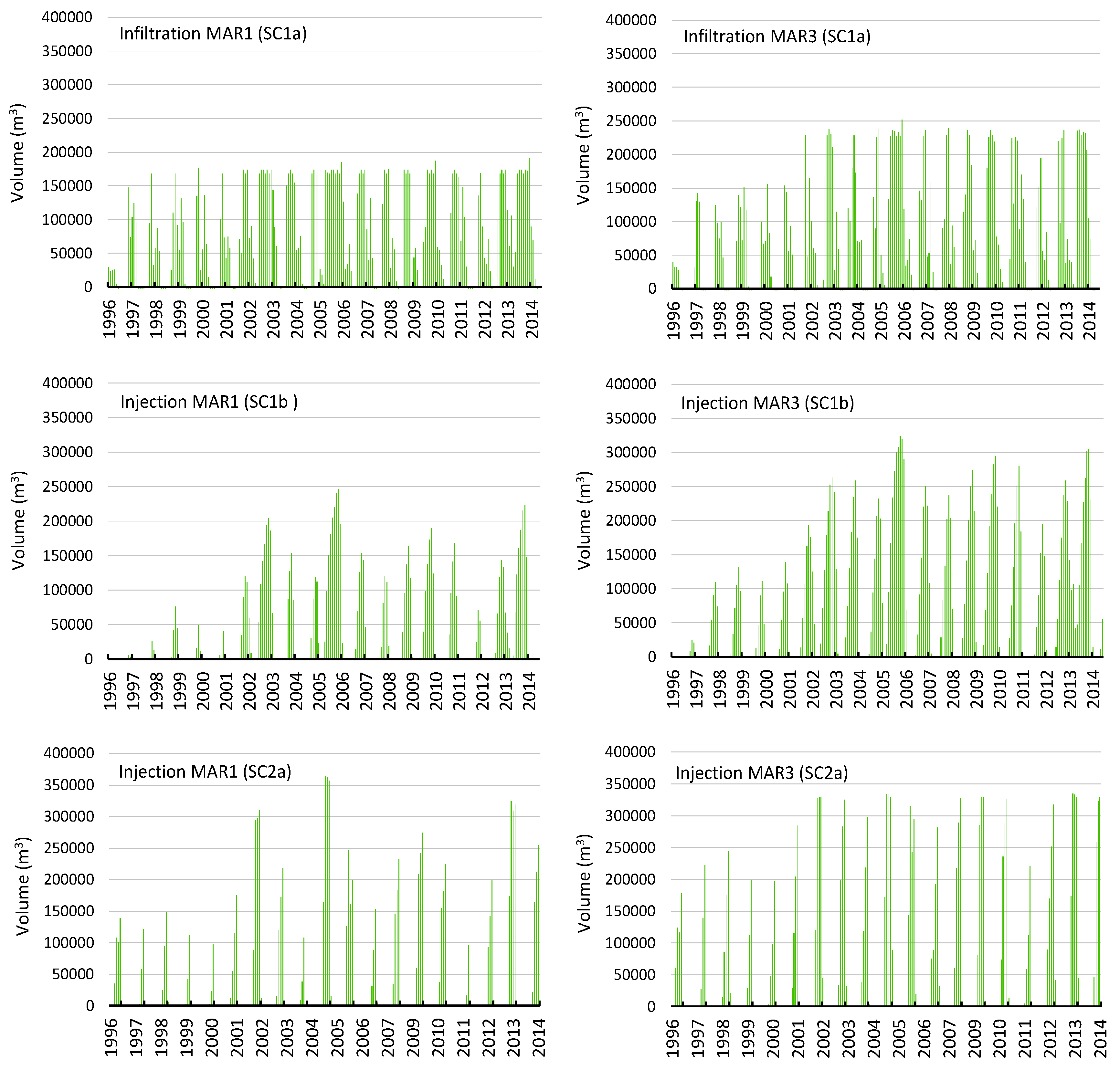
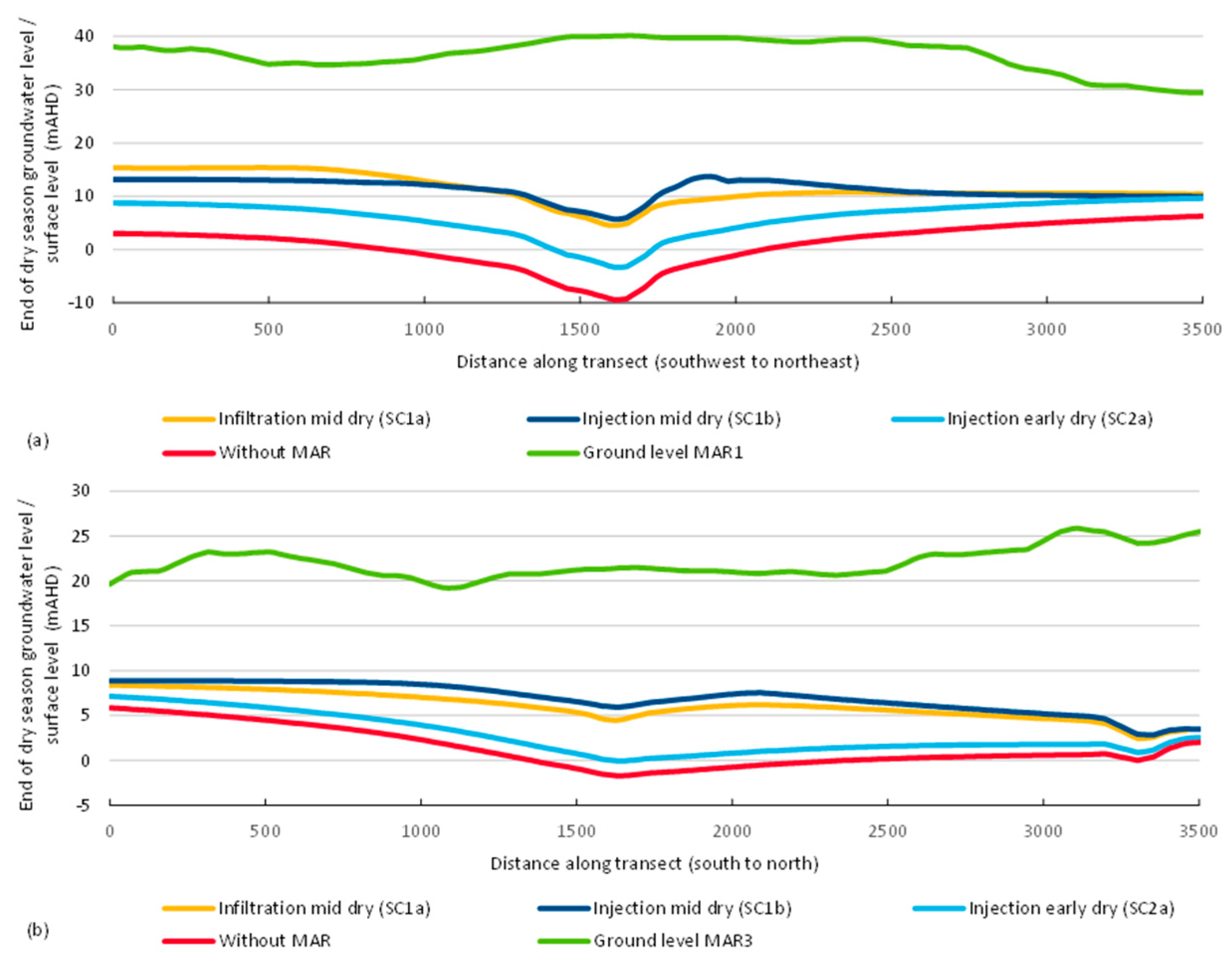
SC1a infiltration mid-dry seasonInfiltration basins in five stressed locations, infiltration rate of 0.015 m/d, recharge targets layer 1 in the model, recharge triggered by water level (MAR1, 2, 4 and 5~18 mAHD; MAR3~10 mAHD)Infiltration rate limited by storage capacity of the aquifer in locations tested
Model discretization too coarse to represent the cone of depression and limits the trigger to recharge in MAR2, 4 & 5
Evaluation focuses on MAR1 & 3, where recharge was triggered
SC1b injection mid-dry seasonASTR wells in five stressed locations, injection rate of 1370 m3/d, recharge targets layer 3 in the model, recharge triggered by water level (MAR1, 2, 4 & 5~18 mAHD; MAR3~10 mAHD)Recharge triggered mainly between August and December
Model discretization too coarse to represent the cone of depression and limits the trigger to recharge in MAR2, 4 & 5
Evaluation focuses on MAR1 & 3, where recharge was triggered
SC1c injection wet seasonASR bores in the confined part of the aquifer, to the north of the stressed locations, recharge targets layer 3 in the modelInjected water does not migrate far from point of injection
End wet season mound ~+10 m
Five ASR bores, approximately 100 m deep were located around 20 km to the north of the stressed area, injection rate of 2,740 m3/d/bore for 120 daysEnd dry season drawdown ~−5 m
Model grid is relatively coarse in this area, monitoring wells are limited
Particle tracking with random walk (longitudinal dispersity (αL) = 100, transverse dispersity (αT) = 10, effective porosity (ηe) = 0.04) was used to evaluate migration of injected water away from the ASR bores
SC2a injection early dry seasonASTR wells in two stressed locations (MAR1 & 3), injection rate of 1,370 m3/d, recharge targets layer 3 in the model, recharge applied at the start of the dry season for ~3 months, pumping from municipal bores in stressed area removedRecharge applied April to July in MAR1 & 3
Constant head maintained from 1 April (or when heads declined between trigger) to 1 July, MAR1 constant head of 36 mAHD, MAR3 constant head of 20 m AHD
SC2b injection wet seasonASR bores in the confined part of the aquifer, to the north of the stressed locations, recharge targets layer 3 in the model, pumping from municipal bores in stressed area removed Injected water does not migrate far from point of injection
End wet season mound ~+20 m
16 ASR bores, approximately 100 m deep were located around 20 km to the north of the stressed area, injection rate of 2740 m3/d/bore for 120 days End dry season drawdown ~−10 m
Model grid is relatively coarse in this area, monitoring wells are limited
Particle tracking with random walk (aL =1 00, aT = 10, ηe = 0.04) was used to evaluate migration of injected water away from the ASR bores

