Groundwater contamination by Chlorinated Hydrocarbons (CHC) has been detected since the 1960s in the main aquifers (shallow and semi-confined) in Milano Functional Urban Area (FUA), but often the sources (named hot-spots in [
1]) are very difficult to locate and quantify over time. Among the possible methods to identify potential sources, there is the so-called “more probable than not”, which may be applied considering two main principles as reported in [
2]. Since the end of the II World War, the FUA in Lombardy Region is one of the most urbanized areas in Europe (
Figure 1). The Northern area of FUA has been characterized by a dense agglomeration of industrial plants; in and around the city of Milano, automotive, refining, chemical, and steel plants have been established from the 1950’s [
3]. Because of the groundwater flow direction, the high hydraulic conductivity and the high groundwater withdrawal rate (yearly average public withdrawal is around 250
), Milano represents a groundwater drainage area, that attracts contaminated groundwater from the surrounding areas. Persisting critical issues deriving from past industrial activities represent environmental problems that the Municipality of Milano is facing nowadays: on one side, degradation of drinking water quality due to the capture of plumes by supply wells; on the other side, the cost of extracted water cleanup interventions, which, in the absence of an identified polluter, befalls on the citizens. In accordance with European Legislative Decree (ELD), in application of the Polluter Pay Principle (PPP), artt. 242 and 244 of Italian Environmental Code (IEC) [
4], establish that in case of soil/groundwater contamination, the chemical characterization of the site and the remediation measures (if necessary) must be imposed by the competent Authority (in the Italian legal framework the Provinces/Districts) only to the liable operator according to his/her fault for negligence, imprudence, in-experiences on the basis of the evidence of a causal link. This frame depends not only on the IEC but also on the Italian Civil Code, and in particular on art. 2043 of Italian Civil Code (IT, 1942 and modifications/integration) on civil liability. The PPP specifies that the identification of the responsible for contamination is a compulsory task to be carried out by the Public Authority. In highly urbanized areas, this legal framework is difficult to apply because of (1) the presence of many industrial plants active from the early ’50 (some of them have since ceased all activities and the presence of pollution down-gradient cannot be easily linked with their historical position) and (2) the groundwater flow is influenced by long-term modifications due to variations in groundwater abstraction for drinking and industrial purposes [
5]. This latter, which produced high variations in flow directions over the latest decades, is known with a high degree of uncertainty. Previous works focused more on developing transport models rather than on carefully reconstructing the groundwater flow directions over time [
6]. As numerical models are very important to support the management of groundwater [
7,
8,
9] and both flow and transport are useful in reconstructing the historical contamination of a hot-spot in hydrogeology, the main aim of the present study is to demonstrate that consider flow direction in time is very important for reconstruct the contamination path and provide stronger tools for Public Authorities to identify the polluters. In order to pursue these goals, the paper (1) simulate a 3D groundwater flow with MODFLOW2005 [
10] in transient mode (from 1980 to 2018), (2) simulate the fate of dissolved CHC contaminants released by a historical source with MT3DMS [
11] (comparing the results previously obtained by a steady-state model [
6]), and (3) forecast the dispersion of CHCs in the coming years, thus providing information to Water Managers and the Public Authority that need actions against the polluter and to plan future groundwater abstraction scenarios.
Study Area, Hydrogeology, and Conceptual Model
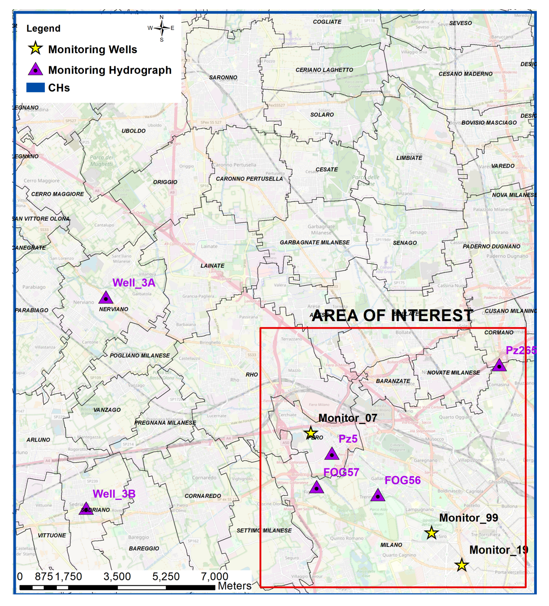
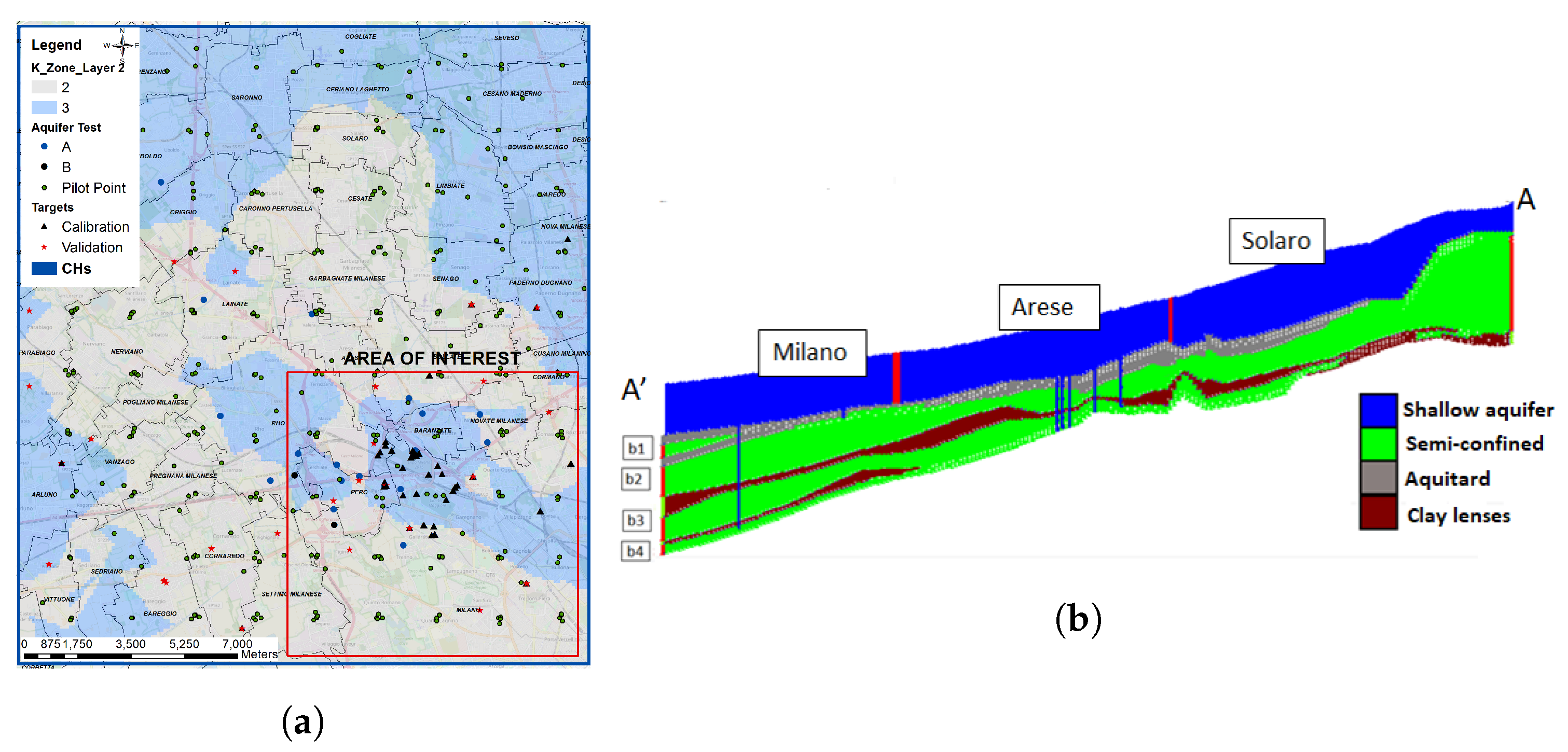
The study area (also called Pilot Area or PA) is located in the central part of Lombardy Region, and it comprises the North-Western area of Milano City and several surrounding municipalities (coloured in violet in
Figure 1). The extension of the Pilot Area is about
. The area is densely populated: the 2014 census reports a total of 617,773 inhabitants. The main hydrography is represented by Seveso and Olona rivers and the Villoresi irrigation canal. Stratigraphic data are available from drilling data collected during different studies [
6,
12,
13,
14,
15,
16] during which the collected sediments were classified and used to interpolate (Leapfrog software [
17]) the main aquifer geometry and hydraulic properties. In this phase of the work was followed the Lombardy Region Aquifer classification [
18] that considers four different hydrostratigraphic unit called A, B, C, and D, originated thanks to the overlay of plio-pleistocenic alluvial sediments [
19]. The main aquifers affected by the contamination are the shallow (Aquifer A, mainly of sandy-gravel composition) and the underlying semi-confined aquifer (Aquifer B), mainly composed by sand interrupted with clay lenses that subdivide it in several silty layers that locally confine this aquifer.
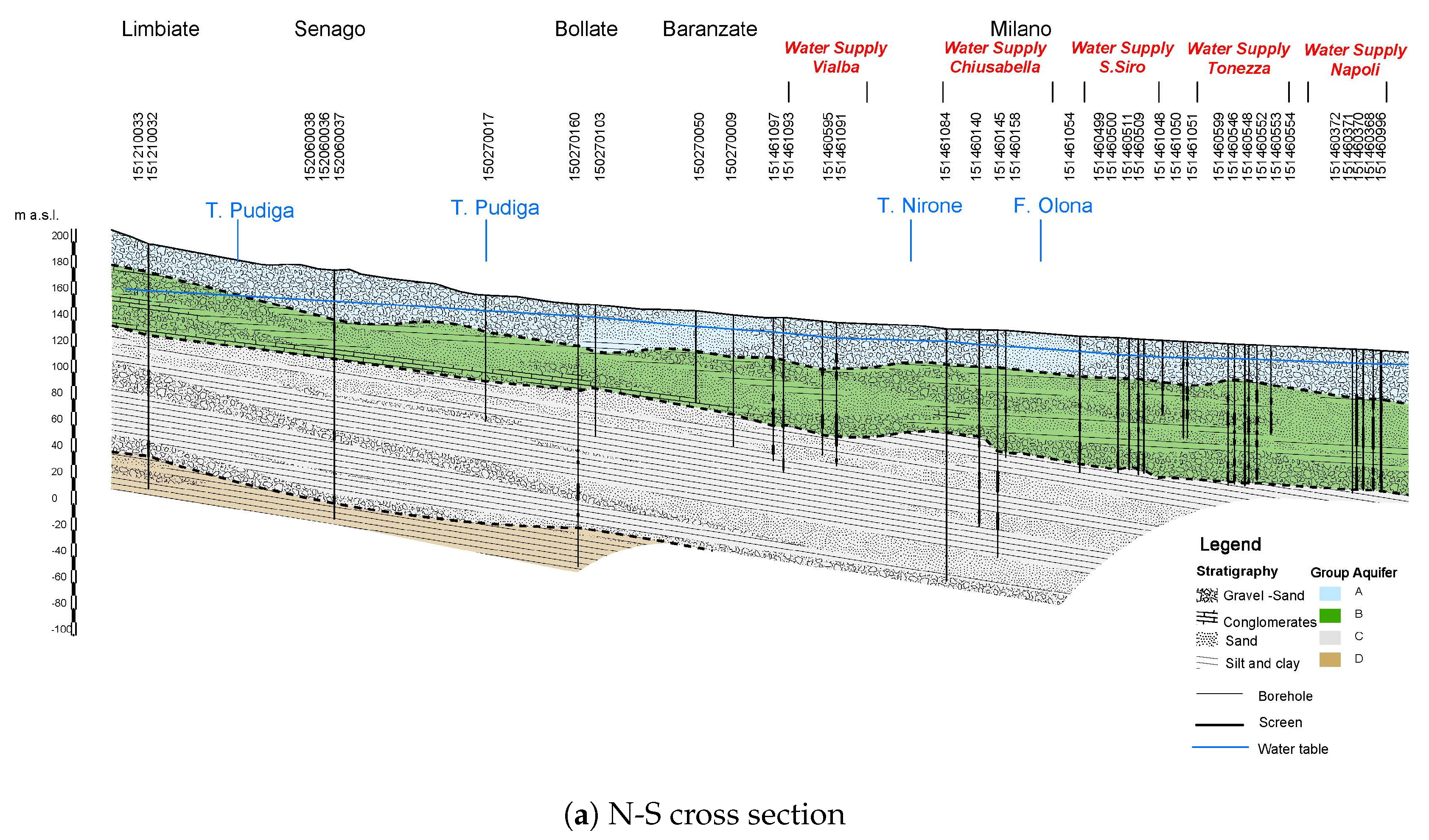
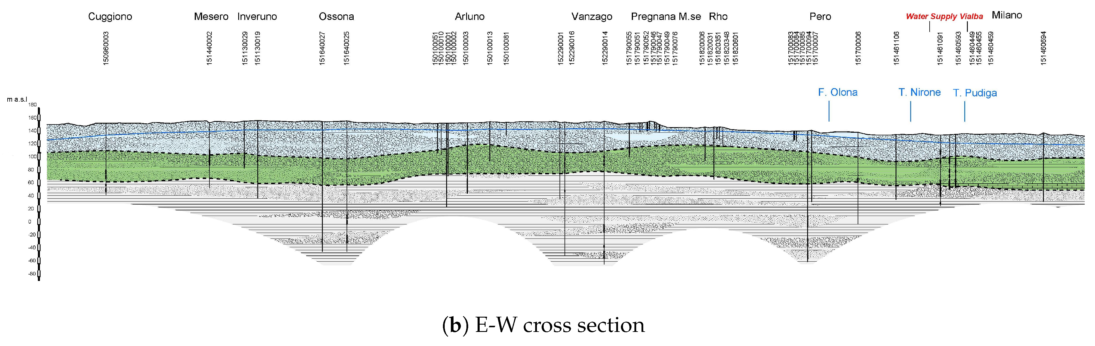
Firstly, by using collected sediments classification, more than ten cross sections were developed (from N to S and from W to E). The structure thus reconstructed was subsequently translated into a MODFLOW2005 3D model. The model only represents the shallow and semi-confined aquifers (called A and B), which are impacted by CHC contamination. The underlying aquifers (Green and Brown), represented in
Figure 2, were not represented considering that the thick clay layer (>5 m) between Aquifer B and C is able to confine the Aquifer C and then is hydraulically separated. A North-South and a East-West cross section of the area are depicted in
Figure 2 and their location is shown in
Figure 1b.
Aquifer A is delimited by the topography surface on top and by a discontinuous clay-silty layer, separating it from aquifer B, on bottom. In Pilot area its average thickness is about 40 m and it is mainly constituted by gravel with presence of sand and a few clay lenses. The clay-silty lens divides hydraulically the two aquifers in the Southern part of the area and it is absent in the North, so that the two bodies constitute an undistinguished aquifer with a saturated thickness of 80–100 m. Aquifer B is separated by the underlying aquifer C by a layer of clay. Its thickness increases towards South from about 40 m to 60 m. The Northern part is mainly constituted by coarse sediments (gravels and coarse sands) while towards the South, an increase in the sandy fraction is observed. The wide presence of clay-silt lenses makes this hydrostratigraphic unit a multilevel aquifer.


