Effects of Ecological Water Conveyance on the Hydrochemistry of a Terminal Lake in an Inland River: A Case Study of Qingtu Lake in the Shiyang River Basin

 , ,
, ,
Abstract
1. Introduction
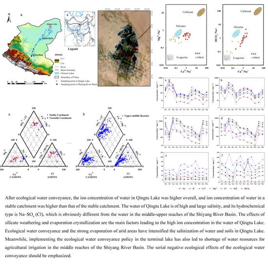
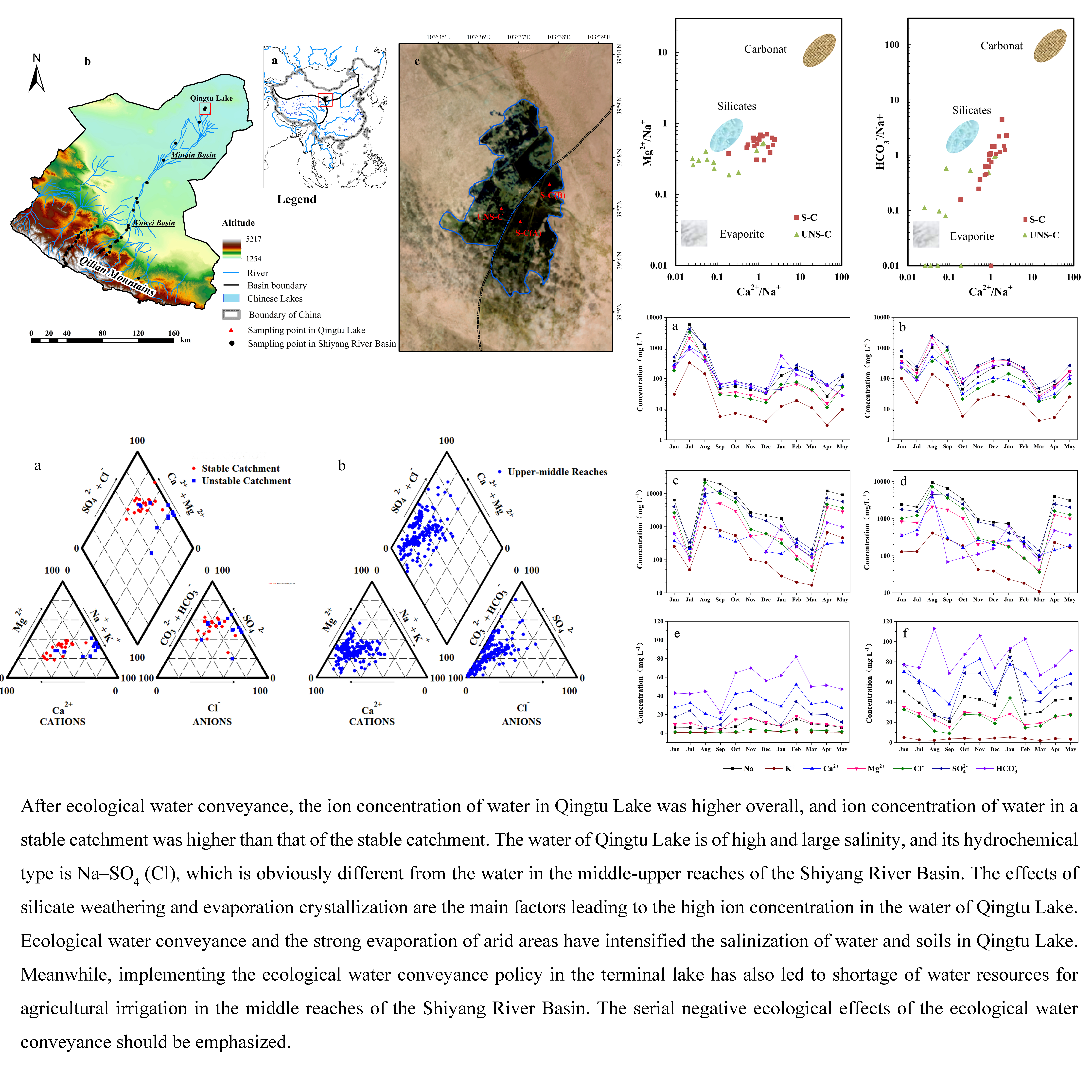
2. Study Area
3. Data and Methods
3.1. Sampling and Chemical Analysis
3.2. Analytical Methods
4. Results and Analysis
4.1. Hydrochemistry Characteristics after Ecological Water Conveyance
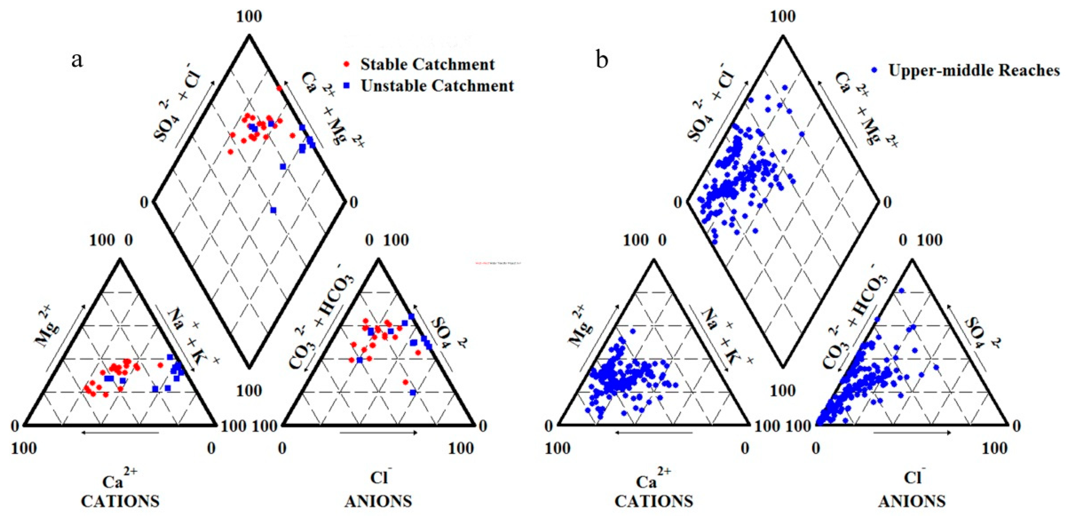
4.2. Characteristics of Lake Water Ions Composition of Lake after Ecological Water Conveyance
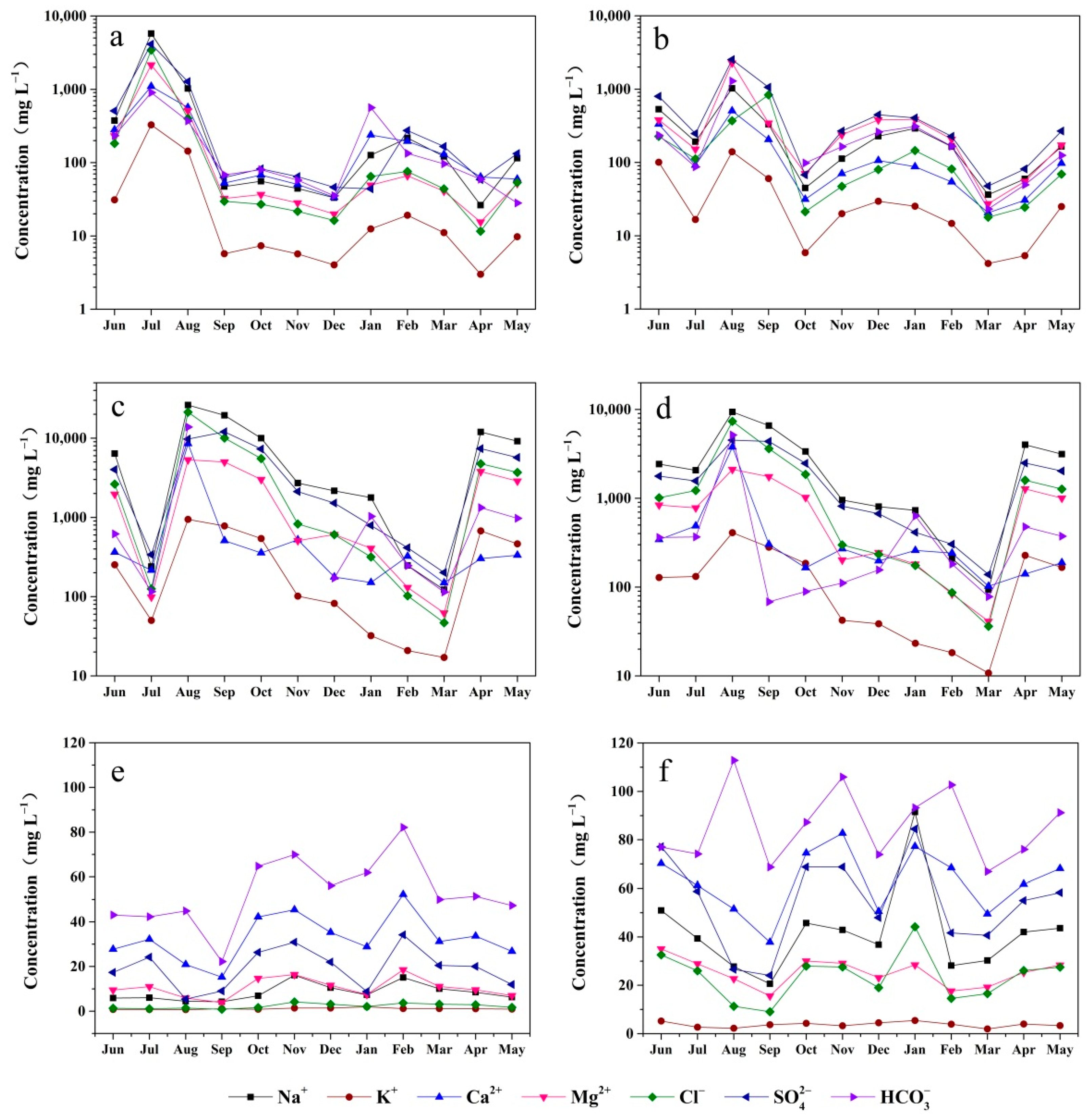
4.3. The Temporal Changes in Ion Concentration of Qingtu Lake
4.4. Spatial Differences of Hydrochemistry Characteristics in Qingtu Lake
5. Discussion
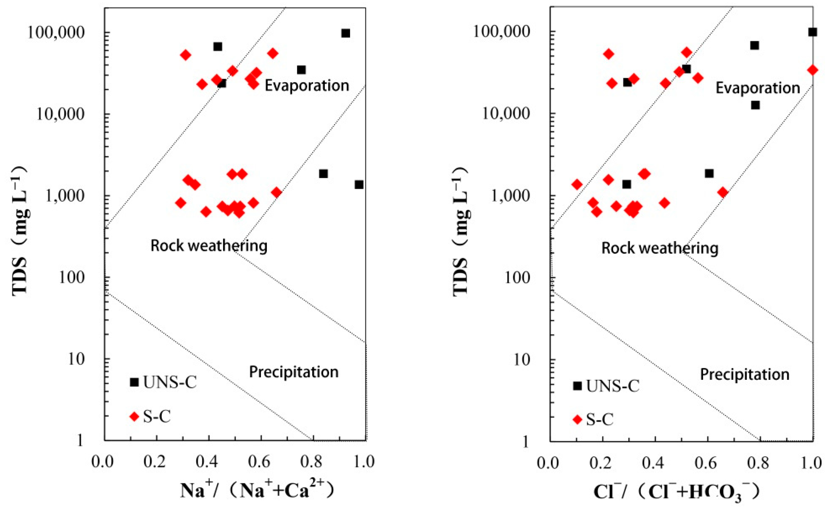
5.1. Controlling Factor of Hydrogeochemistry
5.2. Chemical Weathering
5.3. Impact of Ecological Water Conveyance in Qingtu Lake
5.3.1. Soil and Water May Continue to Salinize in the Future
5.3.2. Comparison of Ion Concentration in Qingtu Lake and Upper-Middle Reaches of the Shiyang River Basin
5.4. Reflection on Ecological Water Conveyance Mode
6. Conclusions
Author Contributions
Funding
Acknowledgments
Conflicts of Interest
Data Availability Statement
References
- Jones, B.F.; Eugster, H.P.; Rettig, S.L. Hydrochemistry of the lake Magadi basin, Kenya. Geochim. Cosmochim. Acta 1977, 41, 53–72. [Google Scholar] [CrossRef]
- Spencer, R.J.; Eugster, H.P.; Jones, B.F.; Rettig, S.L. Geochemistry of Great salt Lake, Utah I: Hydrochemistry since 1850. Geochim. Cosmochim. Acta 1985, 49, 727–737. [Google Scholar] [CrossRef]
- Gibbs, R.J. Mechanisms controlling world water chemistry. Science 1970, 170, 1088–1090. [Google Scholar] [CrossRef] [PubMed]
- Wetzel, R.G. Limnology: Lake and River Ecosystems; Gulf Professional Publishing: Oxford, UK, 2001. [Google Scholar]
- Chen, Y.J.; Chen, Y.N.; Liu, J.Z.; Li, W.; Li, J.; Xu, C. Dynamical variations in groundwater chemistry influenced by intermittent water delivery at the lower reaches of the Tarim River. J. Geogr. Sci. 2005, 15, 13–19. [Google Scholar] [CrossRef]
- Stottlemyer, R.; Toczydlowski, D. Stream chemistry and hydrologic pathways during snowmelt in a small watershed adjacent Lake Superior. Biogeochemistry 1991, 13, 177–197. [Google Scholar] [CrossRef]
- Micklin, P. The Aral Sea Disaster. Annu. Rev. Earth Planet. Sci. 2007, 35, 47–72. [Google Scholar] [CrossRef]
- Chen, Y.N.; Zhang, X.L.; Zhu, X.M.; Li, W.H.; Zhang, Y.M.; Xu, H.L.; Zhang, H.F.; Chen, Y.P. Water transportation and eco-environmental effects in the lower reaches of Tarim River. Sci. China 2004, 34, 475–482. [Google Scholar]
- Arthington, A.H.; Pusey, B.J. Flow restoration and protection in Australian rivers. River Res. Appl. 2010, 19, 377–395. [Google Scholar] [CrossRef]
- Smakhtin, V.U.; Gamage, N.; Bharati, L. Hydrological and environmental issues of interbasin water transfers in India: A case of the Krishna River Basin//IWMI Conference Proceedings. Int. Water Manag. Inst. 2008, 1, 127–130. [Google Scholar]
- Davies, B.R.; Thoms, M.; Meador, M. An assessment of the ecological impacts of inter-basin water transfers, and their threats to river basin integrity and conservation. Aquat. Conserv. Mar. Freshw. Ecosyst. 1992, 2, 325–349. [Google Scholar] [CrossRef]
- Walker, K.F.; Sheldon, F.; Puckridge, J.T. A perspective on dryland river ecosystems. River Res. Appl. 2010, 11, 85–104. [Google Scholar] [CrossRef]
- Zhuang, W. Eco-environmental impact of inter-basin water transfer projects: A review. Environ. Sci. Pollut. Res. 2016, 23, 12867–12879. [Google Scholar] [CrossRef]
- Karthe, D. Environmental changes in Central and East Asian drylands and their effects on major river-lake systems. Quat. Int. 2018, 475, 91–100. [Google Scholar] [CrossRef]
- Micklin, P. The future Aral Sea: Hope and despair. Environ. Earth Sci. 2016, 75, 844. [Google Scholar] [CrossRef]
- Aishan, T.; Halik, Ü.; Cyffka, B.; Kuba, M.; Abliz, A.; Baidourela, A. Monitoring the hydrological and ecological response to water diversion in the lower reaches of the Tarim River, Northwest China. Quat. Int. 2013, 311, 155–162. [Google Scholar] [CrossRef]
- Guo, N.; Liang, Y.; Wang, X.P. Remote sensing monitoring and analysis on effect of environmental recovery in lower reaches of Heihe River due to re-distributing runoff. J. Desert Res. 2004, 24, 740–744. [Google Scholar]
- Zhang, M.M.; Wang, S.A.; Fu, B.J.; Gao, G.Y.; Shen, Q. Ecological effects and potential risks of the water diversion project in the Heihe River Basin. Sci. Total Environ. 2018, 619, 794–803. [Google Scholar] [CrossRef]
- Zhu, G.F.; Zhang, Y.; He, Y.Q.; Zhou, J.J.; Pan, H.X.; Guo, H.W.; Ma, H.Y.; Ma, X.G.; Feng, L. Hydrochemical assessment of the largest desert reservoir in arid oasis area in Asia. Environ. Earth Sci. 2018, 77, 765. [Google Scholar] [CrossRef]
- Yang, Y.C.; Li, J.J.; Chen, F.H.; Burgess, J.; Li, R.C.; Li, D.; Chang, G.Y.; Li, Y.C. The human mechanism research of Minqin Oasis change in the lower reaches of the Shiyang River. Geogr. Res. 2002, 21, 449–458. [Google Scholar] [CrossRef]
- Zhao, J.; Yang, J.X.; Zhu, G.F. Effect of ecological water conveyance on vegetation coverage in surrounding area of the qingtu lake. Arid Zone Res. 2018, 35, 1251–1261. [Google Scholar]
- Chunyu, X.Z.; Huang, F.; Xia, Z.Q.; Zhang, D.R.; Chen, X.; Xie, Y.Y. Assessing the ecological effects of water transport to a lake in arid regions: A case study of Qingtu Lake in Shiyang River basin, Northwest China. Int. J. Environ. Res. Public Health 2019, 16, 145. [Google Scholar] [CrossRef]
- Dong, Z.L.; Xu, X.Y.; Jin, H.X.; Liu, S.J.; Zhang, J.H.; Tang, W.D.; Wang, X.H. The impact of eco-water transportation to the vegetation in tail lake of Shiyang River. J. Arid Land Resour. Environ. 2015, 7, 101–106. [Google Scholar]
- Shi, W.L.; Liu, S.J.; Liu, S.Z.; Yuan, H.B.; Ma, J.P.; Liu, H.J.; An, F.B. Influence analysis of artificial water transfer on the regional ecological environment of Qingtu Lake in the lower reaches of the Shiyang River. Acta Ecol. Sin. 2017, 37, 5951–5960. [Google Scholar] [CrossRef][Green Version]
- Zhu, G.F.; Guo, H.W.; Qin, D.H.; Pan, H.X.; Zhang, Y.; Jia, W.X.; Ma, X.G. Contribution of recycled moisture to precipitation in the monsoon marginal zone: Estimate based on stable isotope data. J. Hydrol. 2019, 569, 423–435. [Google Scholar] [CrossRef]
- Zhao, P.; Xu, X.Y.; Qu, J.Y.; Li, Y.; Jiang, S.X.; Zhang, Y.N. Characteristics of d and δ~(18)o in precipitation in qingtu lake area, at lower reaches of shiyanghe river and its water vapor sources. J. Arid Land Resour. Environ. 2019, 33, 81–85. [Google Scholar]
- Liu, R.R.; Lu, B.H.; Xu, D.; Zhang, J.; Zhai, M.E.; Chang, N.; Li, L.H. Changes of evaporation and its influencing factors in shiyang river basin. J. China Hydrol. 2013, 331, 82–93. [Google Scholar]
- Zhao, X.Y.; Zhao, H.L.; Liu, C.F. The farmers′ livelihood risk and their coping strategy in the downstream of Shiyang River: A case of Minqin Oasis. Geogr. Res. 2015, 34, 922–932. [Google Scholar]
- Zhu, G.F.; Pu, T.; He, Y.Q.; Shi, P.J.; Zhang, T. Seasonal variations of major ions in fresh snow at Baishui Glacier No. 1, Yulong Mountain, China. Environ. Earth Sci. 2013, 69, 1–10. [Google Scholar] [CrossRef]
- Yang, L.; Zhu, G.F.; Shi, P.J.; Li, J.F.; Liu, Y.F.; Tong, H.L.; Hu, P.F.; Liang, F.; Pan, H.X.; Guo, H.W.; et al. Spatiotemporal characteristics of hydrochemistry in Asian arid inland basin–a case study of Shiyang River Basin. Environ. Sci. Pollut. Res. 2018, 25, 2293–2302. [Google Scholar] [CrossRef]
- Shen, Z.L. Hydrogeochemistry Base; Geological Publishing House: Beijing, China, 1993. [Google Scholar]
- Maidment, D.; Stedinger, J.; Vogel, R.; Foufoulageogious, E.; Pilgrim, D.; Cordery, I. Handbook of hydrology. Earth Sci. Rev. 1993, 24, 227–229. [Google Scholar]
- Piper, A.M. A graphic procedure in the geochemical interpretation of water-analyses. Eos Trans. Am. Geophys. Union 1944, 25, 914–928. [Google Scholar] [CrossRef]
- Zhu, G.F.; He, Y.Q.; Pu, T.; Zhang, N.N.; Wang, S.X.; Xin, H.J. Character and sources of conventional anion in different water bodies on the summer in Yulong Snow Mountain area. Environ. Sci. 2011, 32, 626–631. [Google Scholar]
- Gaillardet, J.; Dupré, B.; Louvat, P.; Allegre, C.J. Global silicate weathering and CO2, consumption rates deduced from the chemistry of large rivers. Chem. Geol. 1999, 159, 3–30. [Google Scholar] [CrossRef]
- Kenoyer, G.J.; Bowser, C.J. Groundwater chemical evolution in a sandy silicate aquifer in northern wisconsin: 1. patterns and rates of change. Water Resour. Res. 1992, 28, 579–589. [Google Scholar] [CrossRef]
- Chen, L.J.; Feng, Q.; Wang, Y.; Yu, T.F.; Su, Y.H. Groundwater environment variation in the Minqin Oasis. J. Arid Land Resour. Environ. 2012, 26, 8–13. [Google Scholar]
- Li, Y.H.; Feng, Q.; Chen, L.J.; Zhao, Y.; Yang, H.D. Hydrochemical Characteristics and Evolution Mechanism of Groundwater in the Minqin Oasis. Arid Zone Res. 2017, 34, 733–740. [Google Scholar]
- Shi, Y.F.; Shen, Y.P.; Li, D.L.; Zhang, G.W.; Ding, Y.J.; Hu, R.J.; Kang, E.S. Discussion on the present climate change from warm-dry to warm-wet in Northwest China. Quat. Sci. 2003, 23, 152–164. [Google Scholar] [CrossRef]
- Stocker, T.; Qin, D.; Plattner, G. IPCC, 2013: Climate Change 2013: The Physical Science Basis. Contribution of Working Group I to the Fifth Assessment Report of the Intergovernmental Panel on Climate Change//of the Intergovernmental Panel on Climate Change; IPCC: Geneva, Switzerland, 2013; pp. 710–719. [Google Scholar]
- Richter, B.; Baumgartner, J.; Wigington, R.; Braun, D. How much water does a river need? Freshw. Biol. 1997, 37, 231–249. [Google Scholar] [CrossRef]


| Time (year) | Total Water Inflow into the Lake (104 m3) | Water Surface Area of Catchment (106 m2) | Buried Depth of Groundwater (m) | Annual Change of Groundwater Depth (m) |
|---|---|---|---|---|
| 2008 | - | - | 3.91 | - |
| 2009 | - | - | 3.84 | −0.07 |
| 2010 | 1290 | 3.00 | 3.78 | −0.06 |
| 2011 | 2160 | 10.00 | 3.60 | −0.18 |
| 2012 | 3000 | 15.00 | 3.54 | −0.06 |
| 2013 | 2000 | 15.00 | 3.46 | −0.08 |
| 2014 | 3300 | 22.00 | 3.20 | −0.26 |
| 2015 | 2833 | 22.36 | 3.14 | −0.06 |
| 2016 | 3358 | 25.20 | 2.99 | −0.15 |
| Name of Samplings | Na+ | K+ | Ca2+ | Mg2+ | Cl− | SO42− | HCO3− | pH | TDS | |
|---|---|---|---|---|---|---|---|---|---|---|
| Stable catchment A | Mean | 662.23 | 48.40 | 235.96 | 269.71 | 363.83 | 569.72 | 218.71 | 8.03 | 7970.14 |
| Max | 5761.21 | 327.58 | 1095.32 | 2151.67 | 3438.00 | 4122.10 | 900.59 | 8.75 | 55,200.00 | |
| Min | 26.33 | 2.99 | 33.51 | 15.46 | 11.62 | 43.93 | 28.02 | 7.19 | 656.00 | |
| Stable catchment B | Mean | 264.82 | 37.26 | 390.45 | 136.21 | 169.23 | 537.2 | 255.04 | 8.08 | 17,795.46 |
| Max | 1023.43 | 139.74 | 2271.18 | 505.77 | 835.92 | 2529.06 | 1288.8 | 9.14 | 52,800 | |
| Min | 36.28 | 4.19 | 27.35 | 20.59 | 17.89 | 47.67 | 23.14 | 7.37 | 630 | |
| Unstable catchment | Mean | 7510.84 | 330.02 | 990.64 | 1979.61 | 4158.46 | 4287.46 | 2046.75 | 8.30 | 34,100.86 |
| Max | 26,069.69 | 944.46 | 8485.62 | 5313.64 | 21,283.45 | 12,016.78 | 13,833.34 | 8.96 | 97,400.00 | |
| Min | 121.95 | 17.08 | 149.70 | 62.36 | 46.95 | 201.06 | 114.07 | 7.47 | 1360.00 | |
| Total of Qingtu Lake | Mean | 2898.37 | 143.99 | 561.43 | 834.16 | 1650.72 | 1882.34 | 779.65 | 8.18 | 18,749.14 |
| Max | 26,069.69 | 944.46 | 8485.62 | 5313.64 | 21,283.45 | 12,016.78 | 13,833.34 | 9.14 | 97,400.00 | |
| Min | 26.33 | 2.99 | 27.35 | 15.46 | 11.62 | 43.93 | 23.14 | 7.19 | 614.00 | |
| Variation coefficient | 2.01 | 1.66 | 2.56 | 1.72 | 2.43 | 1.59 | 2.98 | 0.06 | 1.24 | |
| Significant differences | 0.003 ** | 0.002 ** | 0.404 | 0.002 ** | 0.025 * | 0.002 ** | 0.296 | 0.212 | 0.286 |
| Year | − | Cl− | SO42− | Ca2+ | Mg2+ | Na+ | K+ | TDS | Origin |
|---|---|---|---|---|---|---|---|---|---|
| 2010 | 267 | 93 | 307 | 97 | 40 | 109 | 7 | 921 | [37] |
| 2017 | - | 98.95 | 159.58 | 54.45 | 36.67 | 179.24 | 0.89 | 1003 | This study |
| Location | Na+ | K+ | Mg2+ | Ca2+ | Cl− | SO42− | HCO3− | TDS | |
|---|---|---|---|---|---|---|---|---|---|
| Upper reaches | Mean | 8.34 | 1.13 | 11.38 | 34.06 | 2.42 | 19.68 | 56.27 | 243.52 |
| Max | 47.88 | 5.68 | 36.82 | 134.18 | 22.52 | 128.03 | 146.86 | 575.00 | |
| Min | 1.21 | 0.09 | 0.50 | 3.64 | 0.04 | 0.38 | 2.29 | 43.00 | |
| Middle reaches | Mean | 22.94 | 2.36 | 13.57 | 33.06 | 9.91 | 20.36 | 64.12 | 338.01 |
| Max | 72.70 | 18.23 | 69.30 | 147.98 | 44.41 | 50.91 | 415.21 | 1210.00 | |
| Min | 1.63 | 0.54 | 0.69 | 8.39 | 0.15 | 0.43 | 12.69 | 48.00 | |
| Qingtu Lake | Mean | 2898.37 | 143.99 | 834.16 | 561.43 | 1650.72 | 1882.34 | 779.65 | 18,749.14 |
| Max | 26,069.69 | 944.46 | 5313.64 | 8485.62 | 21,283.45 | 12,016.78 | 13,833.34 | 97,400.00 | |
| Min | 26.33 | 2.99 | 15.46 | 27.35 | 11.62 | 43.93 | 23.14 | 614.00 |
© 2019 by the authors. Licensee MDPI, Basel, Switzerland. This article is an open access article distributed under the terms and conditions of the Creative Commons Attribution (CC BY) license (http://creativecommons.org/licenses/by/4.0/).
Share and Cite
Zhang, Y.; Zhu, G.; Ma, H.; Yang, J.; Pan, H.; Guo, H.; Wan, Q.; Yong, L. Effects of Ecological Water Conveyance on the Hydrochemistry of a Terminal Lake in an Inland River: A Case Study of Qingtu Lake in the Shiyang River Basin. Water 2019, 11, 1673. https://doi.org/10.3390/w11081673
Zhang Y, Zhu G, Ma H, Yang J, Pan H, Guo H, Wan Q, Yong L. Effects of Ecological Water Conveyance on the Hydrochemistry of a Terminal Lake in an Inland River: A Case Study of Qingtu Lake in the Shiyang River Basin. Water. 2019; 11(8):1673. https://doi.org/10.3390/w11081673
Chicago/Turabian StyleZhang, Yu, Guofeng Zhu, Huiying Ma, Jianxia Yang, Hanxiong Pan, Huiwen Guo, Qiaozhuo Wan, and Leilei Yong. 2019. "Effects of Ecological Water Conveyance on the Hydrochemistry of a Terminal Lake in an Inland River: A Case Study of Qingtu Lake in the Shiyang River Basin" Water 11, no. 8: 1673. https://doi.org/10.3390/w11081673
APA StyleZhang, Y., Zhu, G., Ma, H., Yang, J., Pan, H., Guo, H., Wan, Q., & Yong, L. (2019). Effects of Ecological Water Conveyance on the Hydrochemistry of a Terminal Lake in an Inland River: A Case Study of Qingtu Lake in the Shiyang River Basin. Water, 11(8), 1673. https://doi.org/10.3390/w11081673