First Steps into an Integrated Karst Aquifer Vulnerability Approach (IKAV). Intrinsic Groundwater Vulnerability Analysis of the Yucatan Karst, Mexico

 ,
, 
 and
and
Abstract
1. Introduction
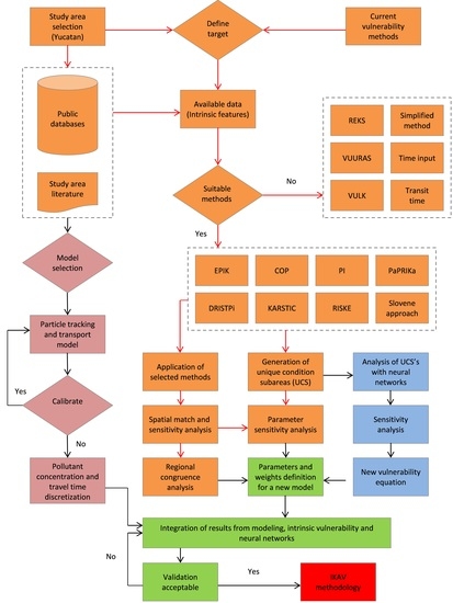
2. Materials and Methods
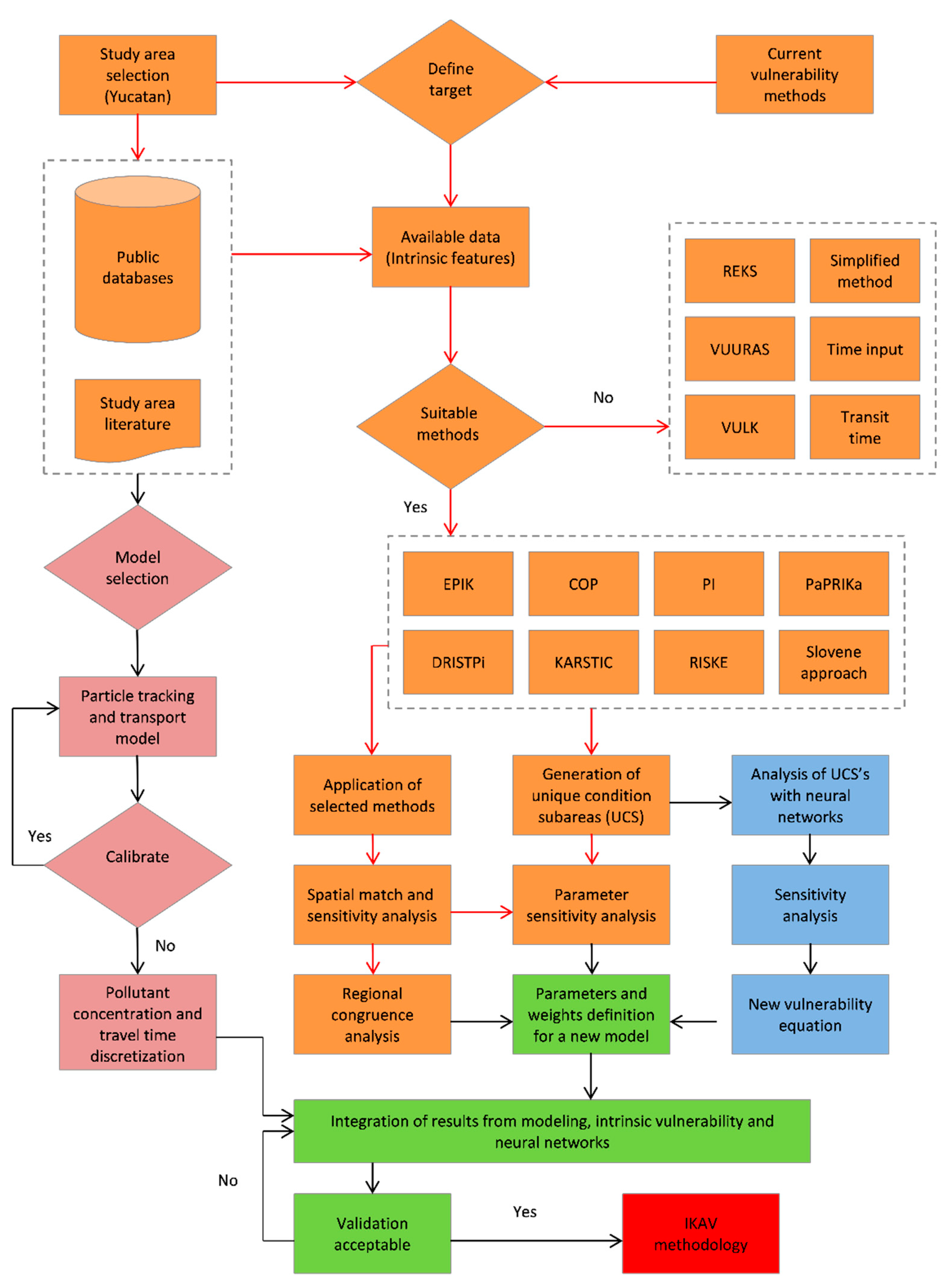
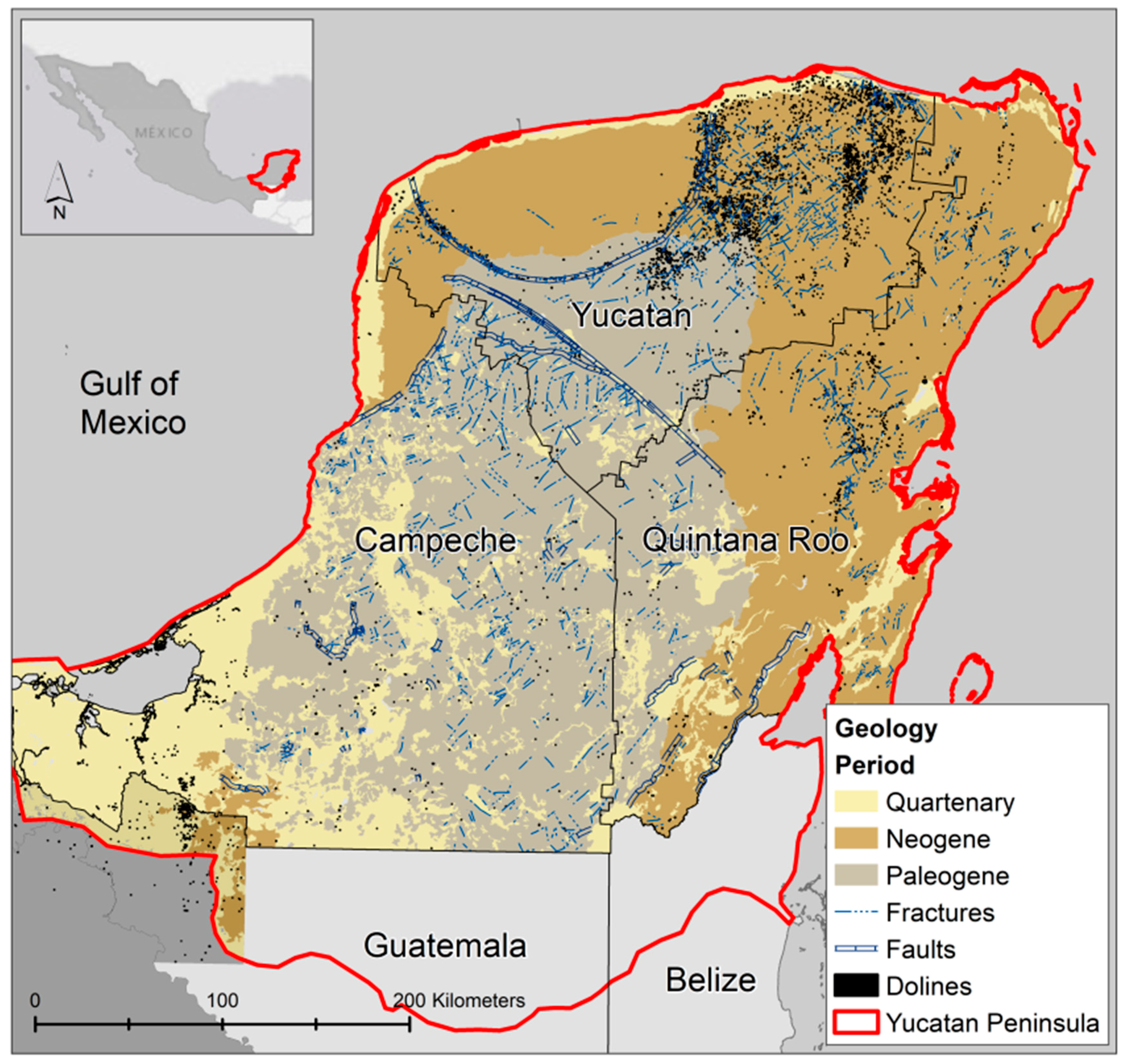
2.1. Study Area
2.2. Methods and Data
2.2.1. DRISTPi Method
2.2.2. KARSTIC Method (KRSTI)
2.2.3. RISKE Method (ISKE)
2.2.4. The Slovene Approach
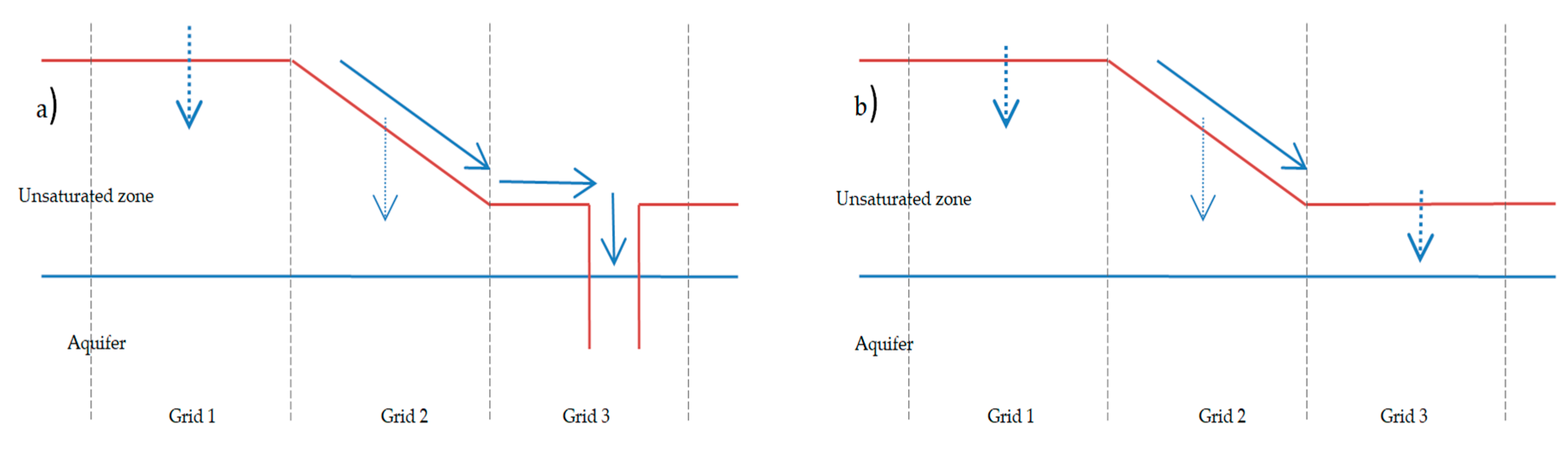
2.3. Sensitivity Analysis
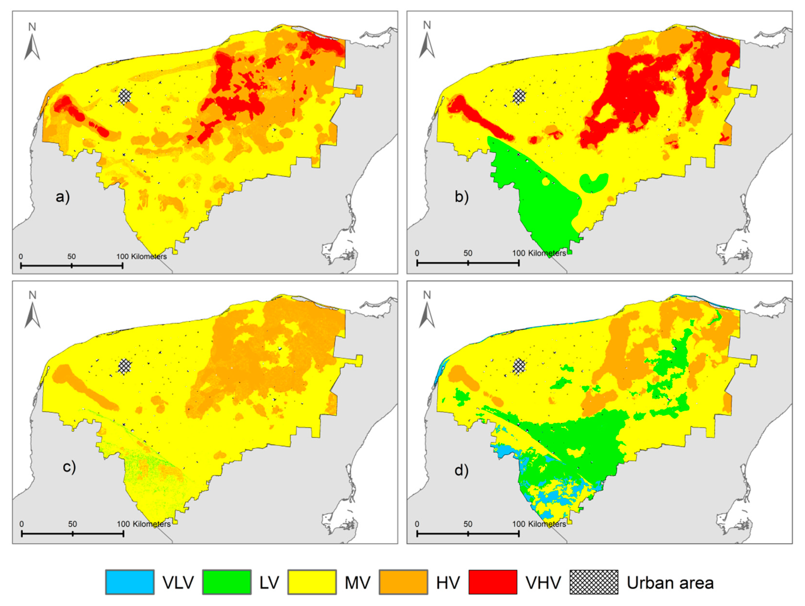
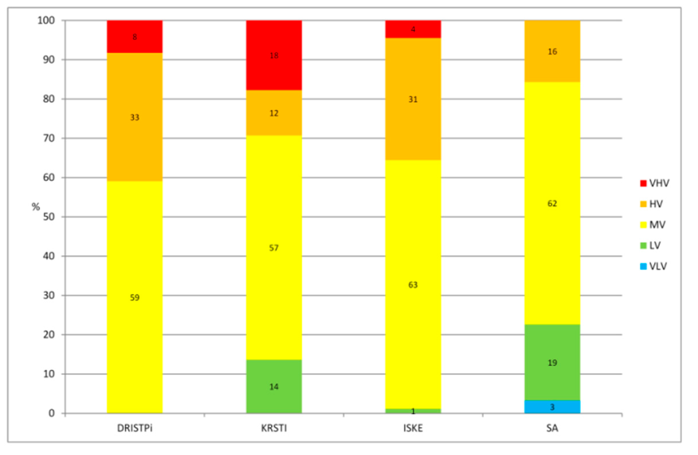
3. Results
Vulnerability and Parameter Sensitivity
4. Discussion
5. Conclusions
Author Contributions
Funding
Acknowledgments
Conflicts of Interest
References
- Ford, D.; Williams, P.D. Karst Hydrogeology and Geomorphology; Unwin Hyman: Boston, MA, USA, 1989. [Google Scholar]
- Foster, S. Fundamental Concepts in Aquifer Vulnerability, Pollution Risk and Protection Strategy. In Vulnerability of Soil and Groundwater to Pollutants. Proc. Inf. TNO Comm. Hydrol. Res. 1987, 38, 69–86. [Google Scholar]
- Iván, V.; Mádl-Szònyi, J. State of the art of karst vulnerability assessment: Overview, evaluation and outlook. Environ. Earth Sci. 2017, 76, 112. [Google Scholar] [CrossRef]
- Albornoz, I.; González, R.; Pacheco, J.; Zetina, C. Revista Latinoamericana el Ambiente y las Ciencias; Benemérita Universidad Autónoma de Puebla: Puebla, Mexico, 2007; pp. 132–136. [Google Scholar]
- Milanović, S.; Stevanović, Z.; Đudrić, D.; Petrović, T.; Milanović, M. Regionalni Pristup Izradi Karte Ugroženosti Podzemnih Voda Srbije–Nova Metoda “IZDAN”, (The New Regional Method for Creation of Groundwater Vulnerability Maps IZDAN—Application on the Republic of Serbia). In Proceedings of the 15th Congress of the Geologists of Serbia with International Participation, Belgrade, Serbia, 26–29 May 2010; pp. 585–590. [Google Scholar]
- Marín, A.I.; Andreo, B. Vulnerability to contamination of Karst Aquifers. In Karst Aquifers—Characterization and Engineering; Springer: Berlin/Heidelberg, Germany, 2015; pp. 251–266. [Google Scholar]
- Andreo, B.; Goldscheider, N.; Vadillo, I.; Vías, J.M.; Neukum, C.; Sinreich, M.; Jiménez, P.; Brechenmacher, J.; Carrasco, F.; Hötzl, H. Karst groundwater protection: First application of a Pan-European Approach to vulnerability, hazard and risk mapping in the Sierra de Líbar (Southern Spain). Sci. Total Environ. 2006, 357, 54–73. [Google Scholar] [CrossRef] [PubMed]
- Ravbar, N.; Goldscheider, N. Comparative application of four methods of groundwater vulnerability mapping in a Slovene karst catchment. Hydrogeol. J. 2009, 17, 725–733. [Google Scholar] [CrossRef]
- Marín, A.; Dörfliger, N.; Andreo, B. Comparative application of two methods (COP and PaPRIKa) for groundwater vulnerability mapping in Mediterranean karst aquifers (France and Spain). Environ. Earth Sci. 2012, 65, 2407–2421. [Google Scholar] [CrossRef]
- Moreno-Gómez, M.; Pacheco, J.; Liedl, R.; Stefan, C. Evaluating the applicability of European karst vulnerability assessment methods to the Yucatan karst, Mexico. Environ. Earth Sci. 2018, 77, 682. [Google Scholar] [CrossRef]
- Malík, P.; Svasta, J. REKS—An Alternative Method of Karst Groundwater Vulnerability Estimation. Hydrogeology and Land Use Management. In Proceedings of the XXIX Congress of the International Association of Hydrogeologist, Bratislava, Slovakia, 6–10 September 1999; pp. 79–85. [Google Scholar]
- Doerfliger, N.; Jeannin, P.Y.; Zwahlen, F. Water vulnerability assessment in karst environments: A new method of defining protection areas using a multi-attribute approach and GIS tools (EPIK method). Environ. Geol. 1999, 39, 165–176. [Google Scholar] [CrossRef]
- Kavouri, K.; Plagnes, V.; Tremoulet, J.; Dörfliger, N.; Rejiba, F.; Marchet, P. PaPRIKa: A method for estimating karst resource and source vulnerability—Application to the Ouysse karst system (In southwest France). Hydrogeol. J. 2011, 19, 339–353. [Google Scholar] [CrossRef]
- Vías, J.; Andreo, B.; Perles, M.; Carrasco, F.; Vadillo, I.; Jiménez, P. Proposed method for groundwater vulnerability mapping in carbonate (karstic) aquifers: The COP method. Hydrogeol. J. 2006, 14, 912–925. [Google Scholar] [CrossRef]
- Ravbar, N.; Goldscheider, N. Proposed methodology of vulnerability and contamination risk mapping for the protection of karst aquifers in Slovenia. Acta Carsologica 2007, 36, 397–411. [Google Scholar] [CrossRef]
- Davis, A.; Long, A.; Nazir, M.; Xiaodan, T. Groundwater Vulnerability in the Rapid Creek Basin Above Rapid City, South Dakota; Department of Geology and Geological Engineering South Dakota School of Mines and Technology: Rapid City, SD, USA, 1994; p. 70. [Google Scholar]
- Jiménez-Madrid, A.; Carrasco, F.; Martínez, C.; Gogu, R. DRISTPI, a new groundwater vulnerability mapping method for use in karstic and non-karstic aquifers. Q. J. Eng. Geol. Hydrogeol. 2013, 46, 245–255. [Google Scholar] [CrossRef]
- Zwahlen, F. Vulnerability and Risk Mapping for the Protection of Carbonate (Karst) Aquifers; Final Report (COST Action 620); European Commission, Directorate-General XII Science: Brussels, Belgium, 2004; p. 297. [Google Scholar]
- Bauer-Gottwein, P.; Gondwe, B.R.; Charvet, G.; Marín, L.E.; Rebolledo-Vieyra, M.; Merediz-Alonso, G. Review: The Yucatán Peninsula karst aquifer, México. Hydrogeol. J. 2011, 19, 507–524. [Google Scholar] [CrossRef]
- Weidie, A. Geology of Yucatan Platform. In Geology and Hydrogeology of the Yucatan and Quaternary Geology of Northeastern Yucatan Peninsula; New Orleans Geological Society: New Orleans, Louisiana, 1985. [Google Scholar]
- Hildebrand, A.R.; Pilkington, M.; Connors, M.; Ortiz-Aleman, C.; Chavez, R.E. Size and structure of the Chicxulub crater revealed by horizontal gravity gradients and cenotes. Nature 1995, 376, 415. [Google Scholar] [CrossRef]
- Pope, K.O.; Ocampo, A.C.; Duller, C.E. Surficial geology of the Chicxulub impact crater, Yucatan, Mexico. Earth Moon Planets 1993, 63, 93–104. [Google Scholar] [CrossRef] [PubMed]
- Perry, E.; Marin, L.; McClain, J.; Velazquez, G. Ring of cenotes (sinkholes), northwest Yucatan, Mexico: Its hydrogeologic characteristics and possible association with the Chicxulub impact crater. Geology 1995, 23, 17–20. [Google Scholar] [CrossRef]
- Pope, K.; Duller, C. Satellite Observations of Ancient and Modern Water Resources in the Yucatan Peninsula. In Memoria, Simposio Latin Americano Sobre Sensores Remotos: Sociedad de Especialistas Latin Americano en Percepción Remoto y Instituto de Geografıa; Universidad Autónoma de México: Mexico City, Mexico, 1989; pp. 91–98. [Google Scholar]
- Connors, M.; Hildebrand, A.R.; Pilkington, M.; Ortiz-Aleman, C.; Chavez, R.E.; Urrutia-Fucugauchi, J.; Graniel-Castro, E.; Camara-Zi, A.; Vasquez, J.; Halpenny, J.F. Yucatan karst features and the size of Chicxulub crater. Geophys. J. Int. 1996, 127, F11–F14. [Google Scholar] [CrossRef]
- Moreno-Gómez, M.; Liedl, R.; Stefan, C. A new GIS-Based model for karst dolines mapping using LiDAR. Application of a multidepth threshold approach in the Yucatan karst, Mexico. Remote Sens. 2019, 11, 1147. [Google Scholar] [CrossRef]
- Doehring, D.O.; Butler, J.H. Hydrogeologic constraints on Yucatán’s development. Science 1974, 186, 591–595. [Google Scholar] [CrossRef]
- Lesser, I.; Weidie, A. Region 25, Yucatán Peninsula. In Hydrogeology: The geology of North America; Geological Society of America: Boulder, CO, USA, 1988; Volumes 0–2, pp. 237–242. [Google Scholar]
- CNA National Water Commission. Statistics on Water in México, 2015 Edition, National Water Commission: Coyoacan, México, 2015.
- Lesser, J.M. Estudio hidrogeologico e hidrogeoquimico de la Peninsula de Yucatan; Secretaría de Recursos Hidraulicos, Dirección de Geohidrología y de Zonas Aridas: Mérida, Mexico, 1976. [Google Scholar]
- Gondwe, B.R.; Lerer, S.; Stisen, S.; Marín, L.; Rebolledo-Vieyra, M.; Merediz-Alonso, G.; Bauer-Gottwein, P. Hydrogeology of the south-eastern Yucatan Peninsula: New insights from water level measurements, geochemistry, geophysics and remote sensing. J. Hydrol. 2010, 389, 1–17. [Google Scholar] [CrossRef]
- SMN Datos Climáticos Diarios del CLICOM del SMN a Través de su Plataforma web del CICESE. Available online: http://clicom-mex.cicese.mx (accessed on 6 October 2018).
- Escolero, O.; Marin, L.E.; Torres-Onofre, S. Dynamic of the freshwater–saltwater interface in a karstic aquifer under extraordinary recharge action: The Merida Yucatan case study. Environ. Geol. 2007, 51, 719–723. [Google Scholar] [CrossRef]
- Marin, L.E. Field Investigations and Numerical Simulation of Groundwater Flow in the Karstic Aquifer of Northwestern Yucatan; Northern Illinois University: DeKalb, IL, USA, 1990. [Google Scholar]
- Perry, E.; Velazquez-Oliman, G.; Marin, L. The hydrogeochemistry of the karst aquifer system of the northern Yucatan Peninsula, Mexico. Int. Geol. Rev. 2002, 44, 191–221. [Google Scholar] [CrossRef]
- Gonzalez-Herrera, R. Evolution of Groundwater Contamination in the Yucatan Karstic Aquifer. Master’s Thesis, University of Waterloo, Waterloo, ON, Canada, 1992. Unpublished. [Google Scholar]
- González-Herrera, R.; Sánchez-y-Pinto, I.; Gamboa-Vargas, J. Groundwater-flow modeling in the Yucatan karstic aquifer, Mexico. Hydrogeol. J. 2002, 10, 539–552. [Google Scholar] [CrossRef]
- SEMARNAP Mapa de Suelos Dominantes de la República Mexicana. Obtenidos a Través de la Plataforma CONABIO. Available online: http://www.conabio.gob.mx (accessed on 18 May 2018).
- Sánchez, O.S.; Islebe, G.A.; Hernández, M.V. Flora arbórea y caracterización de gremios ecológicos en distintos estados sucesionales de la selva mediana de Quintana Roo. For. Veracruzana 2007, 9, 17–26. [Google Scholar]
- Zamora Crescencio, P.; García Gil, G.; Flores Guido, J.S.; Ortiz, J.J. Estructura y composición florística de la selva mediana subcaducifolia en el sur del estado de Yucatán, México. Polibotánica 2008, 26, 39–66. [Google Scholar]
- Ávila, J.P.; Rocher, L.C.; Sansores, A.C. Delineación de la zona de protección hidrogeológica para el campo de pozos de la planta Mérida I, en la ciudad de Mérida, Yucatán, México. Ingeniería 2004, 8, 7–16. [Google Scholar]
- Escolero, O.A.; Marin, L.E.; Steinich, B.; Pacheco, J. Delimitation of a hydrogeological reserve for a city within a karstic aquifer: The Merida, Yucatan example. Landsc. Urban Plan. 2000, 51, 53–62. [Google Scholar] [CrossRef]
- Aller, L.; Lehr, J.H.; Petty, R.; Bennett, T. DRASTIC: A Standardized System to Evaluate Groundwater Pollution Potential Using Hydrogeologic Settings; National Water Well Association: Worthington, OH, USA, 1987. [Google Scholar]
- Petelet-Giraud, E.; Doerfliger, N.; Crochet, P. RISKE: Methode d’evaluation multicritere de la cartographie de la vulnerabilite des aquiferes karstiques. Application aux systemes des Fontanilles et Cent-Fonts (Herault, Sud de la France). Hydrogeologie 2000, 4, 71–88. [Google Scholar]
- Lodwick, W.; Monson, W.; Svoboda, L. Attribute error and sensitivity analysis of map operations in geographical information systems. Int. J. Geogr. Inf. Sci. 1990, 4, 413–428. [Google Scholar] [CrossRef]
- Gogu, R.C.; Dassargues, A. Sensitivity analysis for the EPIK method of vulnerability assessment in a small karstic aquifer, southern Belgium. Hydrogeol. J. 2000, 8, 337–345. [Google Scholar] [CrossRef]
- Napolitano, P.; Fabbri, A. Single-Parameter Sensitivity Analysis for Aquifer Vulnerability Assessment Using DRASTIC and SINTACS. In Series of Proceedings and Reports-Intern Assoc Hydrological Sciences; IAHS Publications: Oxfordshire, UK, 1996; Volume 235, pp. 559–566. [Google Scholar]


| Map Layers | DRISTPi | KARSTIC | RISKE | SA | PaPRIKa | COP | Pi | EPIK | Data |
|---|---|---|---|---|---|---|---|---|---|
| Soil thickness | X | X | X | X | X | X | Borehole data a | ||
| Soil texture | X | X | X | X | X | X | X | Borehole data a | |
| Lithology | X | X | X | X | X | X | X | Lithology map a | |
| Fracturing | X | X | X | X | X | X | X | Fracturing maps a | |
| Unsaturated zone (Depth) | X | X | X | X | X | Digital elevation model b/groundwater levels a | |||
| Epikarst | X | X | X | X | Sinkholes density map | ||||
| Confined conditions | X | X | Literature review | ||||||
| Slope | X | X | X | X | X | X | X | X | DEM b |
| Vegetation | X | X | X | X | Vegetation maps a | ||||
| Karstification | X | X | X | X | X | X | X | Sinkhole/fissure density maps | |
| Rainfall volume | X | X | 25 years historic data c | ||||||
| Rainfall intensity | X | X | 25 years historic data c | ||||||
| Recharge | X | X | X | Precipitation c, APLIS d method | |||||
| Surface features | X | Sinkholes and fracturing maps a | |||||||
| Effective field capacity | X | Settled with minimum values | |||||||
| Hydraulic conductivity (soil) | X | Soil maps a, Saxton equations | |||||||
| Hydraulic conductivity (aquifer) | X | Na | |||||||
| Rock reservoir | X | X | X | Na |
| Vulnerability Description | Vulnerability Class | Original Test Site | |||
|---|---|---|---|---|---|
| Sierra de Cañete, Spain and Neblón River Basin, Belgium | Rapid Creek Basin, South Dakota, USA | Fontanilles and Cent-Fonts Karstic Aquifers, France | Podstenjšek Springs Catchment, Slovenia | ||
| DRISTPi Index | KARSTIC Index | RISKE Index | SA Index | ||
| Very low | 1 | 17–50 | 0–200 | 0–0.8 | 4–15 |
| Low | 2 | 50–80 | 200–350 | >0.8–1.6 | 2–4 |
| Moderate | 3 | 80–110 | 350–600 | >1.6–2.4 | 1–2 |
| High | 4 | 110–140 | 600–800 | >2.4–3.2 | 0.5–1 |
| Very high | 5 | >140 | >800 | >3.2–4 | 0–0.5 |
| Sensitivity | D | R | I | S | T | Pi |
|---|---|---|---|---|---|---|
| Yucatan Sxi | 1.1 | 2.7 | 3.8 | 2.6 | 2.4 | 1.6 |
| All UCS Sxi | 1.6 | 2.1 | 2.8 | 1.4 | 2.4 | 2.6 |
| Yucatan Vxi | 12.1 | 29.7 | 34.0 | 5.0 | 5.6 | 13.6 |
| All UCS Vxi | 10.3 | 22.1 | 28.0 | 11.6 | 5.5 | 22.5 |
| Yucatan Cs | 45.2 | 72.5 | 100.0 | 9.3 | 19.2 | 24.9 |
| All UCS Cs | 34.7 | 70.7 | 83.2 | 38.8 | 18.4 | 66.2 |
| Sensitivity | K | R | S | T | I |
|---|---|---|---|---|---|
| Yucatan Sxi | 4.1 | 2.1 | 6.2 | 5.5 | 14.0 |
| UCS Sxi | 28.7 | 13.5 | 15.4 | 16.9 | 25.7 |
| Yucatan Vxi | 12.3 | 22.1 | 5.7 | 7.3 | 52.6 |
| UCS Vxi | 37.1 | 9.4 | 6.3 | 4.0 | 40.1 |
| Yucatan Cs | 23.0 | 24.6 | 0.0 | 0.1 | 25.0 |
| UCS Cs | 55.9 | 12.3 | 7.7 | 4.5 | 57.7 |
| Sensitivity | I | S | K | E |
|---|---|---|---|---|
| Yucatan Sxi | 0.17 | 0.10 | 0.08 | 0.08 |
| UCS Sxi | 0.12 | 0.08 | 0.05 | 0.05 |
| Yucatan Vxi | 39.6 | 37.6 | 23.3 | 24.1 |
| UCS Vxi | 37.1 | 35.1 | 26.2 | 23.2 |
| Yucatan Cs | 68.0 | 25.3 | 45.0 | 44.8 |
| UCS Cs | 98.8 | 14.6 | 15.7 | 14.4 |
| Sensitivity | Os | Ol | Sv | Sf | Rd | Se |
|---|---|---|---|---|---|---|
| Yucatan Sxi | 0.29 | 0.08 | 0.12 | 0.23 | 0.15 | 0.09 |
| UCS Sxi | 0.13 | 0.18 | 0.17 | 0.19 | 0.16 | 0.17 |
| Yucatan Vxi | 65.98 | 34.02 | 5.56 | 38.10 | 11.11 | 0.00 |
| UCS Vxi | 31.86 | 68.14 | 30.47 | 52.78 | 25.69 | 30.56 |
| Yucatan Cs | 100 | 97.7 | 0 | 48.7 | 3.01 | 0 |
| UCS Cs | 99.9 | 99.9 | 99.6 | 96.5 | 91.3 | 66.7 |
| Method | Vulnerability Class | ||||
|---|---|---|---|---|---|
| VHV | HV | MV | LV | VLV | |
| DRISTPi | Fissuring | Fissuring | Lithology | Not displayed | Not displayed |
| KRSTI | Sinkhole density and fissures | Sinkhole density and fissures | Shallow water table | Deep water table | Not displayed |
| ISKE | Negligible | Sinkhole density and fissures | Low slope percentage | High slope percentage | Not displayed |
| SA | Not displayed | Sinkhole density and fissures | Soil thickness and texture | Soil thickness and texture | Soil thickness and texture |
© 2019 by the authors. Licensee MDPI, Basel, Switzerland. This article is an open access article distributed under the terms and conditions of the Creative Commons Attribution (CC BY) license (http://creativecommons.org/licenses/by/4.0/).
Share and Cite
Moreno-Gómez, M.; Martínez-Salvador, C.; Moulahoum, A.-W.; Liedl, R.; Stefan, C.; Pacheco, J. First Steps into an Integrated Karst Aquifer Vulnerability Approach (IKAV). Intrinsic Groundwater Vulnerability Analysis of the Yucatan Karst, Mexico. Water 2019, 11, 1610. https://doi.org/10.3390/w11081610
Moreno-Gómez M, Martínez-Salvador C, Moulahoum A-W, Liedl R, Stefan C, Pacheco J. First Steps into an Integrated Karst Aquifer Vulnerability Approach (IKAV). Intrinsic Groundwater Vulnerability Analysis of the Yucatan Karst, Mexico. Water. 2019; 11(8):1610. https://doi.org/10.3390/w11081610
Chicago/Turabian StyleMoreno-Gómez, Miguel, Carolina Martínez-Salvador, Ahmed-Walid Moulahoum, Rudolf Liedl, Catalin Stefan, and Julia Pacheco. 2019. "First Steps into an Integrated Karst Aquifer Vulnerability Approach (IKAV). Intrinsic Groundwater Vulnerability Analysis of the Yucatan Karst, Mexico" Water 11, no. 8: 1610. https://doi.org/10.3390/w11081610
APA StyleMoreno-Gómez, M., Martínez-Salvador, C., Moulahoum, A.-W., Liedl, R., Stefan, C., & Pacheco, J. (2019). First Steps into an Integrated Karst Aquifer Vulnerability Approach (IKAV). Intrinsic Groundwater Vulnerability Analysis of the Yucatan Karst, Mexico. Water, 11(8), 1610. https://doi.org/10.3390/w11081610