Estimation of Sediment Yield and Maximum Outflow Using the IntErO Model in the Sarada River Basin of Nepal


Abstract
1. Introduction
2. Materials and Methods
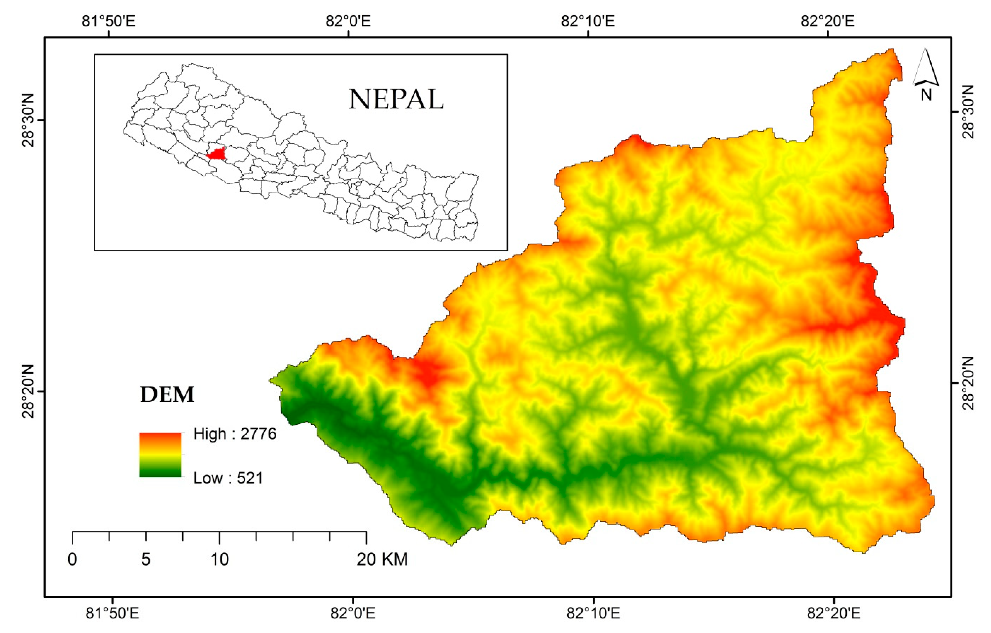
2.1. Study Area and Data
2.2. Soil Erosion Model
2.2.1. IntErO Model
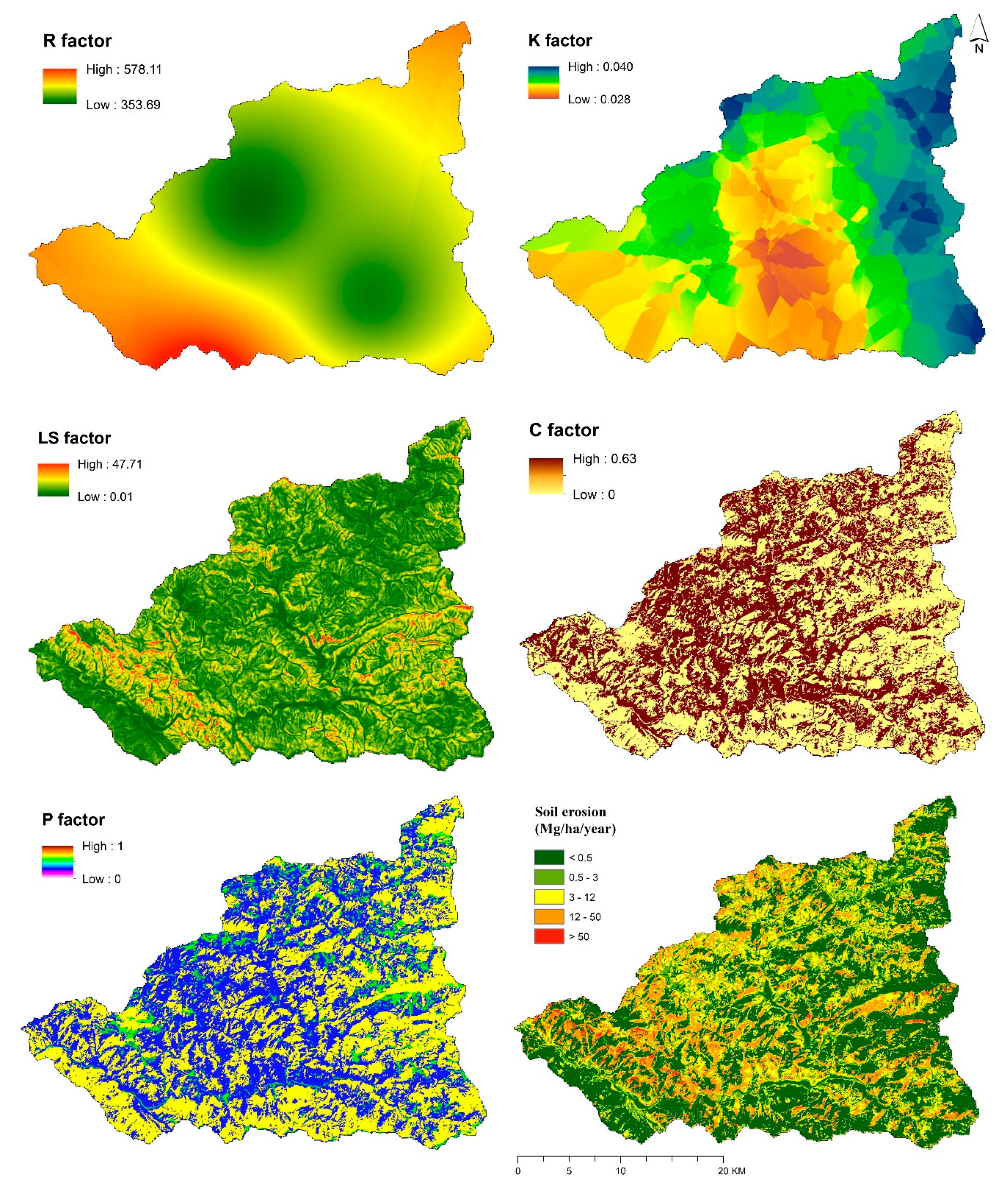
2.2.2. RUSLE Model
3. Results
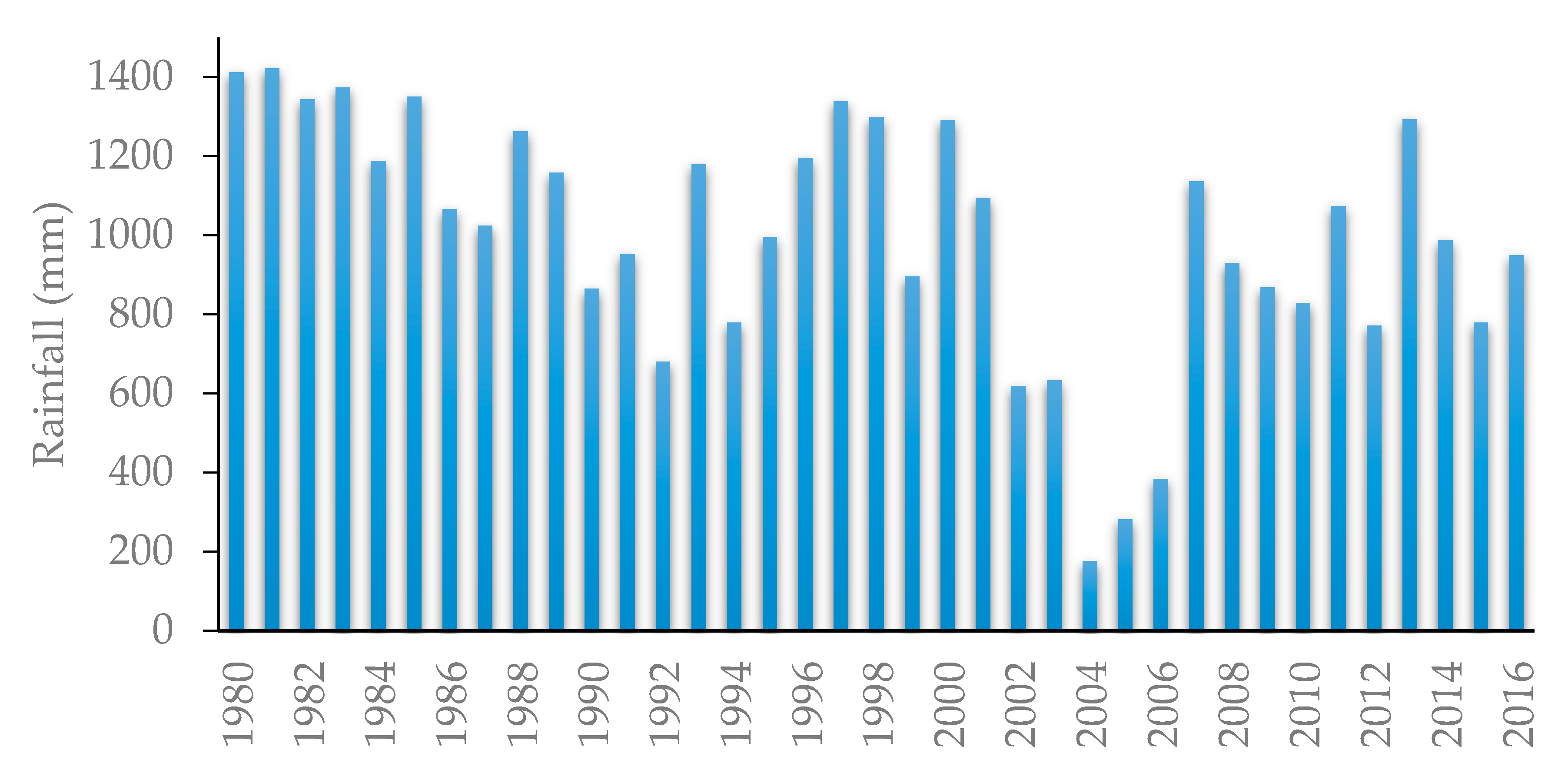
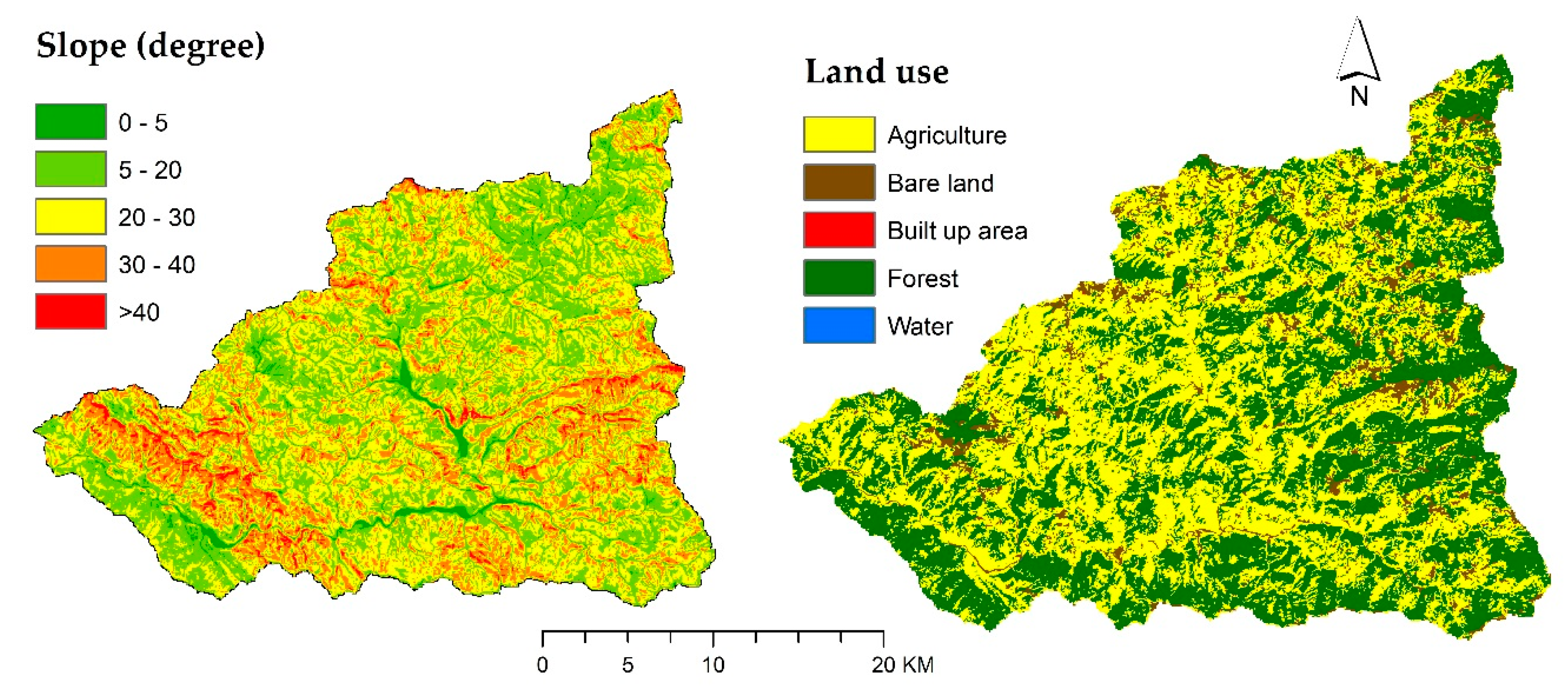
3.1. Physio-Geographical and Climate Characteristics
3.2. The Geology and Soils
3.3. Vegetation and Land Use
3.4. Modeling Soil Loss with the IntErO
3.5. Modeling Soil Loss with RUSLE
4. Discussion
5. Conclusions
Author Contributions
Funding
Acknowledgments
Conflicts of Interest
References
- Novara, A.; Pisciotta, A.; Minacapilli, M.; Maltese, A.; Capodici, F.; Cerdà, A.; Gristina, L. The impact of soil erosion on soil fertility and vine vigor. A multidisciplinary approach based on field, laboratory and remote sensing approaches. Sci. Total Environ. 2018, 622, 474–480. [Google Scholar] [CrossRef] [PubMed]
- Gholami, L.; Batista, P.; Behzadfar, A.; Darvishan, A.; Behzadfar, M. Application of IntErO model for soil loss estimation case study: S7-1 Watershed of Shirindareh river basin, Iran. In Proceedings of the VII International Scientific Agriculture Symposium, “Agrosym 2016”, Jahorina, Bosnia and Herzegovina, 6–9 October 2016; pp. 2169–2177. [Google Scholar]
- Darvishan, A.K.; Derivandi, M.; Aliramee, R.; Khorsand, M.; Spalevic, V.; Gholami, L.; Vujacic, D. Efficiency of IntErO Model to Predict Soil Erosion Intensity and Sediment Yield in Khamsan Representative Watershed (West of Iran). AGROFOR 2018, 3. [Google Scholar] [CrossRef]
- Keesstra, S.; Mol, G.; de Leeuw, J.; Okx, J.; Molenaar, C.; de Cleen, M.; Visser, S. Soil-related sustainable development goals: Four concepts to make land degradation neutrality and restoration work. Land 2018, 7, 133. [Google Scholar] [CrossRef]
- Keesstra, S.D.; Bouma, J.; Wallinga, J.; Tittonell, P.; Smith, P.; Cerdà, A.; Montanarella, L.; Quinton, J.N.; Pachepsky, Y.; Van Der Putten, W.H.; et al. The significance of soils and soil science towards realization of the United Nations sustainable development goals. Soil 2016, 2, 111–128. [Google Scholar] [CrossRef]
- Food and Agriculture Organization. Status of the World‘s Soil Resources (SWSR)—Main Report; Food and Agriculture Organization of the United Nations and Intergovernmental Technical Panel on Soils: Rome, Italy, 2015. [Google Scholar]
- Spalevic, V.; Lakicevic, M.; Radanovic, D.; Billi, P.; Barovic, G.; Vujacic, D.; Sestras, P.; Darvishan, A.K. Ecological-Economic (Eco-Eco) Modelling in the River Basins of Mountainous Regions: Impact of Land Cover Changes on Sediment Yield in the Velicka Rijeka, Montenegro. Not. Bot. Horti Agrobot. Cluj-Napoca 2017, 45, 602–610. [Google Scholar] [CrossRef]
- Ministry of Agricultural Development. Statistical Information on Nepalese Agriculture 2012/2013; Agri-Business Promotion and Statistics Division, Statistics Section: Kathmandu, Nepal, 2013.
- Upadhayay, H.R.; Smith, H.G.; Griepentrog, M.; Bodé, S.; Bajracharya, R.M.; Blake, W.; Cornelis, W.; Boeckx, P. Community managed forests dominate the catchment sediment cascade in the mid-hills of Nepal: A compound-specific stable isotope analysis. Sci. Total Environ. 2018, 637, 306–317. [Google Scholar] [CrossRef]
- Chalise, D.; Kumar, L.; Kristiansen, P. Land Degradation by Soil Erosion in Nepal: A Review. Soil Syst. 2019, 3, 12. [Google Scholar] [CrossRef]
- Atreya, K.; Sharma, S.; Bajracharya, R.M.; Rajbhandari, N.P. Applications of reduced tillage in hills of central Nepal. Soil Tillage Res. 2006, 88, 16–29. [Google Scholar] [CrossRef]
- Atreya, K.; Sharma, S.; Bajracharya, R.M.; Rajbhandari, N.P. Developing a sustainable agro-system for central Nepal using reduced tillage and straw mulching. J. Environ. Manag. 2008, 88, 547–555. [Google Scholar] [CrossRef]
- Thomas, J.; Joseph, S.; Thrivikramji, K. Assessment of soil erosion in a tropical mountain river basin of the southern Western Ghats, India using RUSLE and GIS. Geosci. Front. 2018, 9, 893–906. [Google Scholar] [CrossRef]
- Jain, M.K.; Das, D. Estimation of sediment yield and areas of soil erosion and deposition for watershed prioritization using GIS and remote sensing. Water Resour. Manag. 2010, 24, 2091–2112. [Google Scholar] [CrossRef]
- Batista, P.V.G.; Silva, M.L.N.; Silva, B.P.C.; Curi, N.; Bueno, I.T.; Júnior, F.W.A.; Davies, J.; Quinton, J. Modelling spatially distributed soil losses and sediment yield in the upper Grande River Basin-Brazil. Catena 2017, 157, 139–150. [Google Scholar] [CrossRef]
- Van Eck, C.M.; Nunes, J.P.; Vieira, D.C.; Keesstra, S.; Keizer, J.J. Physically-Based Modelling of the Post-Fire Runoff Response of a Forest Catchment in Central Portugal: Using Field versus Remote Sensing Based Estimates of Vegetation Recovery. Land Degrad. Dev. 2016, 27, 1535–1544. [Google Scholar] [CrossRef]
- Masselink, R.; Temme, A.J.A.M.; Giménez, R.; Casalí, J.; Keesstra, S.D. Assessing hillslope-channel connectivity in an agricultural catchment using rare-earth oxide tracers and random forests models. Cuadernos de Investigación Geográfica 2017, 43, 19–39. [Google Scholar] [CrossRef]
- Vaezi, A.R.; Abbasi, M.; Bussi, G.; Keesstra, S. Modeling sediment yield in semi-arid pasture micro-catchments, NW Iran. Land Degrad. Dev. 2017, 28, 1274–1286. [Google Scholar] [CrossRef]
- Spalevic, V. Impact of Land Use on Runoff and Soil Erosion in Polimlje. Ph.D. Thesis, Faculty of Agriculture of the University of Belgrade, Belgrade, Serbia, 2011. [Google Scholar]
- International Centre for Integrated Mountain Development. Geology of Nepal; ICIMOD: Kathmandu, Nepal, 2007. [Google Scholar]
- Chalise, D.; Kumar, L. Land Use Change Impacts on Soil Erosion Dynamics in Western Nepal; University of New England: Armidale, Australia, 2018. [Google Scholar]
- Knisel, W.G. CREAMS: A Field Scale Model for Chemicals, Runoff, and Erosion from Agricultural Management Systems; Conservation Research Report (USA); Dept. of Agriculture: Washington, DC, USA, 1980.
- Beasley, D.B.; Huggins, L.F.; Monke, E.J. ANSWERS: A model for watershed planning. Trans. ASAE 1980, 23, 938–944. [Google Scholar] [CrossRef]
- Young, R.; Onstad, C.; Bosch, D.; Anderson, W. AGNPS, Agricultural Non-Point-Source Pollution Model: A Watershed Analysis Tool; Conservation Research Report 35; US Dept. of Agriculture: Washington, DC, USA, 1987.
- Nearing, M.A.; Foster, G.R.; Lane, L.J.; Finkner, S.C. A process-based soil erosion model for USDA-Water Erosion Prediction Project technology. Trans. ASAE 1989, 32, 1587–1593. [Google Scholar] [CrossRef]
- Wischmeier, W.H.; Smith, D.D. Predicting rainfall erosion losses-a guide to conservation planning. In Predicting Rainfall Erosion Losses-A Guide to Conservation Planning; USDA, Science and Education Administration: Hyattsville, MD, USA, 1978. [Google Scholar]
- Wischmeier, W.H.; Smith, D.D. Predicting Rainfall-Erosion Losses from Cropland East of the Rocky Mountains: Guide for Selection of Practices for Soil and Water Conservation; Agricultural Research Service, US Department of Agriculture: Washington, DC, USA, 1965; Volume 282.
- Williams, J. Sediment routing for agricultural watersheds. J. Am. Water Resour. Assoc. 1975, 11, 965–974. [Google Scholar] [CrossRef]
- Renard, K.G.; Foster, G.R.; Weesies, G.A.; Porter, J.P. RUSLE: Revised universal soil loss equation. J. Soil Water Conserv. 1991, 46, 30–33. [Google Scholar]
- Walling, D. Erosion and sediment yield research—Some recent perspectives. J. Hydrol. 1988, 100, 113–141. [Google Scholar] [CrossRef]
- Ferro, V.; Porto, P.; Tusa, G. Testing a distributed approach for modelling sediment delivery. Hydrol. Sci. J. 1998, 43, 425–442. [Google Scholar] [CrossRef]
- Carson, M.A.; Kirkby, M.J. Hillslope form and process. Science 1972, 178, 1083–1084. [Google Scholar]
- Mitasova, H.; Hofierka, J.; Zlocha, M.; Iverson, L.R. Modelling topographic potential for erosion and deposition using GIS. Int. J. Geograph. Inf. Syst. 1996, 10, 629–641. [Google Scholar] [CrossRef]
- Zhao, G.; Kondolf, G.M.; Mu, X.; Han, M.; He, Z.; Rubin, Z.; Wang, F.; Gao, P.; Sun, W. Sediment yield reduction associated with land use changes and check dams in a catchment of the Loess Plateau, China. Catena 2017, 148, 126–137. [Google Scholar] [CrossRef]
- Spalevic, V. Application of Computer-Graphic Methods in the Studies of Draining out and Intensities of Ground Erosion in the Berane Valley; Faculty of Agriculture of the University of Belgrade: Belgrade, Serbia, 1999. [Google Scholar]
- Spalevic, V.; Dlabac, A.; Jovovic, Z.; Rakocevic, J.; Radunovic, M.; Spalevic, B.; Fustic, B. The “Surface and distance Measuring“ Program. Acta Agric. Serbica 1999, 4, 63–71. [Google Scholar]
- Gavrilovic, S. Inzenjering o Bujicnim Tokovima i Eroziji; Izgradnja: Beograd, Serbia, 1972. [Google Scholar]
- Spalevic, V.; Curovic, M.; Uzen, N.; Simunic, I.; Vukelic-Shutoska, M. Calculation of soil erosion intensity and runoff in the river basin of Ljesnica, Northeast of Montenegro. In Proceedings of the 24th International Scientific-Expert Conference on Agriculture and Food Industry, Sarajevo, Bosnia and Herzegovina, 25–28 September 2013. [Google Scholar]
- Milanesi, L.; Pilotti, M.; CleriCi, A.; GavriloviC, Z. Application of an improved version of the erosion potential method in alpine areas. Ital. J. Eng. Geol. Environ. 2015, 1, 17–30. [Google Scholar]
- Noori, H.; Siadatmousavi, S.M.; Mojaradi, B. Assessment of sediment yield using RS and GIS at two sub-basins of Dez Watershed, Iran. Int. Soil Water Conserv. Res. 2016, 4, 199–206. [Google Scholar] [CrossRef]
- Efthimiou, N.; Lykoudi, E. Soil erosion estimation using the EPM model. Bull. Geol. Soc. Greece 2016, 50, 305–314. [Google Scholar] [CrossRef][Green Version]
- Tatjana, K. EPM for Soil Loss Estimation in Different Geomorphologic Conditions and Data Conversion by Using GIS. Master’s Thesis, Mediterranean Agronomic Institute of Chania, Hania, Greece, 2014. [Google Scholar]
- Dragičević, N.; Whyatt, D.; Davies, G.; Karleuša, B.; Ožanić, N. Erosion model sensitivity to Land cover inputs: Case study of the Dubračina catchment, Croatia. In Proceedings of the GIS Research UK 22nd Annual Conference GISRUK 2014, Scotland, UK, 16–18 April 2014. [Google Scholar]
- Haghizadeh, A. Forecasting sediment with erosion potential method with emphasis on land use changes at basin. Electr. J. Geotech. Eng. 2009, 14, 1–12. [Google Scholar]
- Dragičević, N.; Karleuša, B.; Ožanić, N. Erosion potential method (Gavrilović method) sensitivity analysis. Soil Water Res. 2017, 12, 51–59. [Google Scholar] [CrossRef]
- Renard, K.; Foster, G.; Weesies, G.; McCool, D.; Yoder, D. Predicting Soil Erosion by Water: A Guide to Conservation Planning with the Revised Universal Soil Loss Equation (RUSLE); Handbook 703; Food and Agriculture Organization of the United States: Washington, DC, USA, 1997. [Google Scholar]
- Xu, Y.-Q.; Shao, X.-M.; Kong, X.-B.; Peng, J.; Cai, Y.-L. Adapting the RUSLE and GIS to model soil erosion risk in a mountains karst watershed, Guizhou Province, China. Environ. Monit. Assess. 2008, 141, 275–286. [Google Scholar] [CrossRef]
- Harper, D. Improving the accuracy of the universal soil loss equation in Thailand. In Proceedings of the Fifth International Conservation Conferences, Bangkok, Thailand, 18–29 January 1988. [Google Scholar]
- Panday, D.; Maharjan, B.; Chalise, D.; Shrestha, R.K.; Twanabasu, B. Digital soil mapping in the Bara district of Nepal using kriging tool in ArcGIS. PLoS ONE 2018, 13, e0206350. [Google Scholar] [CrossRef]
- Panday, D.; Ojha, R.B.; Chalise, D.; Das, S.; Twanabasu, B. Spatial variability of soil properties under different land use in the dang district of Nepal. Cogent Food Agric. 2019. [Google Scholar] [CrossRef]
- Ligonja, P.; Shrestha, R. Soil erosion assessment in kondoa eroded area in Tanzania using universal soil loss equation, geographic information systems and socioeconomic approach. Land Degrad. Dev. 2015, 26, 367–379. [Google Scholar] [CrossRef]
- Wall, G.; Coote, D.; Pringle, E.; Shelton, I. RUSLEFAC—Revised Universal Soil loss Equation for Application in Canada: A Handbook for Estimating Soil Loss from Water Erosion in Canada; Contribution No. AAFC/AAC2244E; Research Branch, Agriculture and Agri-Food Canada: Ottawa, ON, Canada, 2002; Volume 117. [Google Scholar]
- Šurda, P.; Šimonides, I.; Antal, J. A determination of area of potential erosion by geographic information systems. J. Environ. Eng. Landsc. Manag. 2007, 15, 144–152. [Google Scholar] [CrossRef]
- Chalise, D.; Kumar, L.; Shriwastav, C.P.; Lamichhane, S. Spatial assessment of soil erosion in a hilly watershed of Western Nepal. Environ. Earth Sci. 2018, 77, 685. [Google Scholar] [CrossRef]
- Jain, S.K.; Kumar, S.; Varghese, J. Estimation of soil erosion for a Himalayan watershed using GIS technique. Water Resour. Manag. 2001, 15, 41–54. [Google Scholar] [CrossRef]
- Jung, H.; Jeon, S.; Lee, D. Development of soil water erosion module using GIS and RUSLE. In Proceedings of the 9th Asia-Pacific Integrated Model (AIM) International Workshop, Tsukuba, Japan, 12–13 March 2004; pp. 12–13. [Google Scholar]
- Ministry of Forests and Soil Conservation. Adaptation for Smallholders in Hilly Areas Project; GIS Based Assessment of Sarada Watershed Salyan; Ministry of Forests and Soil Conservation: Kathmandu, Nepal, 2017. [Google Scholar]
- Ojha, T.P. Magnetostratigraphy, Topography and Geology of the Nepal Himalaya: A GIS and Paleomagnetic Approach; The University of Arizona: Tucson, AZ, USA, 2009. [Google Scholar]
- Spalevic, V.; Hübl, J.; Hasenauer, H.; Curovic, M. Calculation of soil erosion intensity in the Bosnjak Watershed, Polimlje River Basin, Montenegro. In Proceedings of the 5th International Symposium “Agrosym“, Jahorina, Bosnia and Herzegovina, 23–26 October 2014; pp. 730–738. [Google Scholar]
- Spalevic, V.; Radanovic, D.; Behzadfar, M.; Djekovic, V.; Andjelkovic, A.; Milosevic, N. Calculation of the sediment yield of the Trebacka Rijeka, Polimlje, Montenegro. Agric. For. 2014, 60, 259–272. [Google Scholar]
- Borrelli, P.; Märker, M.; Panagos, P.; Schütt, B. Modeling soil erosion and river sediment yield for an intermountain drainage basin of the Central Apennines, Italy. Catena 2014, 114, 45–58. [Google Scholar] [CrossRef]
- Jha, M.K.; Paudel, R.C. Erosion predictions by empirical models in a mountainous watershed in Nepal. J. Spat. Hydrol. 2010, 10, 89–102. [Google Scholar]
- Mandal, U.K. Geo-information-Based Soil Erosion Modeling for Sustainable Agriculture Development in Khadokhola Watershed, Nepal. In Land Cover Change and Its Eco-environmental Responses in Nepal; Springer: Berlin, Germany, 2017; pp. 223–241. [Google Scholar]
- Nayak, T.; Jaiswal, R.; Galkate, R.; Thomas, T. Impact Assessment of Alternate Land Cover and Management Practices on Soil Erosion: A Case Study. In Hydrologic Modeling; Springer: Berlin, Germany, 2018; pp. 211–223. [Google Scholar]
- Uddin, K.; Abdul Matin, M.; Maharjan, S. Assessment of Land Cover Change and Its Impact on Changes in Soil Erosion Risk in Nepal. Sustainability 2018, 10, 4715. [Google Scholar] [CrossRef]
- Uddin, K.; Murthy, M.; Wahid, S.M.; Matin, M.A. Estimation of soil erosion dynamics in the Koshi basin using GIS and remote sensing to assess priority areas for conservation. PLoS ONE 2016, 11, e0150494. [Google Scholar] [CrossRef]
- Gardner, R.A.M.; Gerrard, A.J. Runoff and soil erosion on cultivated rainfed terraces in the Middle Hills of Nepal. Appl. Geogr. 2003, 23, 23–45. [Google Scholar] [CrossRef]
- Gabet, E.J.; Burbank, D.W.; Pratt-Sitaula, B.; Putkonen, J.; Bookhagen, B. Modern erosion rates in the High Himalayas of Nepal. Earth Planet. Sci. Lett. 2008, 267, 482–494. [Google Scholar] [CrossRef]
- Rodrigo-Comino, J.; Keesstra, S.; Cerdà, A. Soil Erosion as an Environmental Concern in Vineyards: The Case Study of Celler del Roure, Eastern Spain, by Means of Rainfall Simulation Experiments. Beverages 2018, 4, 31. [Google Scholar] [CrossRef]
- Antoneli, V.; Rebinski, E.; Bednarz, J.; Rodrigo-Comino, J.; Keesstra, S.; Cerdà, A.; Pulido Fernández, M. Soil erosion induced by the introduction of new pasture species in a faxinal farm of Southern Brazil. Geosciences 2018, 8, 166. [Google Scholar] [CrossRef]
- Keesstra, S.; Temme, A.; Schoorl, J.; Visser, S. Evaluating the hydrological component of the new catchment-scale sediment delivery model LAPSUS-D. Geomorphology 2014, 212, 97–107. [Google Scholar] [CrossRef]
- Rodrigo-Comino, J.; Taguas, E.; Seeger, M.; Ries, J.B. Quantification of soil and water losses in an extensive olive orchard catchment in Southern Spain. J. Hydrol. 2018, 556, 749–758. [Google Scholar] [CrossRef]
- Kumar, S. Effect of different vegetation systems on soil erosion and soil nutrients in red soil region of southeastern China. Pedosphere 2003, 13, 121–128. [Google Scholar]
- Liu, Y.; Tao, Y.; Wan, K.; Zhang, G.; Liu, D.; Xiong, G.; Chen, F. Runoff and nutrient losses in citrus orchards on sloping land subjected to different surface mulching practices in the Danjiangkou Reservoir area of China. Agric. Water Manag. 2012, 110, 34–40. [Google Scholar] [CrossRef]
- Cerdà, A.; Rodrigo-Comino, J.; Novara, A.; Brevik, E.C.; Vaezi, A.R.; Pulido, M.; Giménez-Morera, A.; Keesstra, S.D. Long-term impact of rainfed agricultural land abandonment on soil erosion in the Western Mediterranean basin. Prog. Phys. Geogr. 2018, 42, 202–219. [Google Scholar] [CrossRef]
- Feng, T.; Wei, W.; Chen, L.; Rodrigo-Comino, J.; Die, C.; Feng, X.; Ren, K.; Brevik, E.C.; Yu, Y. Assessment of the impact of different vegetation patterns on soil erosion processes on semiarid loess slopes. Earth Surf. Process. Landf. 2018, 43, 1860–1870. [Google Scholar] [CrossRef]


| Erosion Process Intensity | Prevailing Erosion Type | Z | Mean Value Z |
|---|---|---|---|
| Excessive | Deep Mixed Surface | 1.51 1.21–1.50 1.01–1.20 | 1.25 |
| Strong | Deep Mixed Surface | 0.91–1 0.81–0.90 0.71–0.80 | 0.85 |
| Medium | Deep Mixed Surface | 0.61–0.70 0.51–0.60 0.41–0.50 | 0.55 |
| Low | Deep Mixed Surface | 0.31–0.40 0.25–0.30 0.20–0.24 | 0.30 |
| Very low | Deep Mixed Surface | 0.01–0.19 | 0.10 |
| Coefficient of Soil Cover | Xa Value |
| Areas without vegetal cover (Bare land, building area, water) | 0.8–0.9 |
| Crop fields, meadows, grasslands | 0.6–0.8 |
| Built-up areas and crops, degraded “matorral shrublands” | 0.4–0.6 |
| Arboricultural lands, Clear “matorral shrublands” | 0.2–0.4 |
| Reforested areas, dense forests, dense “matorral shrublands” | 0.05–0.2 |
| Coefficient of Soil Resistance | Y Value |
| Marls, clays, poorly consolidated yellow sands and rocks with little resistance | 1.3–1.7 |
| Weak rock, fine clayey pelites with microbereccia beds, recent quaternary scree | 1–1.3 |
| Rock with moderate erosion resistance, limestone formations, fluvial terraces | 0.6–1 |
| Hard rock, sandstone of the Numidian nappe | 0.5–0.6 |
| Coefficient of Type and Extent of Erosion | ϕ Value |
| Deep ravines, landslides, badlands areas and bank undercutting | 0.8–0.9 |
| Sheet erosion, less than 50% of the catchment area with rill and gullies erosion | 0.6–0.7 |
| 20% of the area attacked by surface erosion, minor slips in stream channels | 0.3–0.5 |
| Land surface without visible erosion, mostly crop fields | 0.1–0.2 |
| LULC | C Value | P Value |
|---|---|---|
| Agriculture | 0.63 | 0.5 |
| Bare land | 0.09 | 0.7 |
| Built up area | 0.09 | 1 |
| Forest | 0.003 | 0.8 |
| Water bodies | 0 | 0 |
| Geological Class | Major Rocks Present | Area | |
|---|---|---|---|
| km2 | % | ||
| Kalikot formation | Limestone, schist, gneiss | 2.18 | 0.25 |
| Kushma formation | Quartzite, chlorotic phyllite | 240.49 | 27.59 |
| Lakharpata formation | Dolostone and limestone in the lower part; limestone, shale and phyllite in the middle part and limestone, dolostone and few quartzites in the upper part | 216.43 | 24.83 |
| Lower siwalik | Sandstone, siltstone and mudstone | 55.28 | 6.34 |
| Melpani formation | Ferruginous quartzites, sandstones, dark shales, few limestones, conglomerates | 8.04 | 0.92 |
| Ranimata formation | Phyllite with thin beds of quartzite | 227.54 | 26.10 |
| Sangram formation | Orthoquartzite in the lower part and shale, few limestones and orthoquartzite in the upper part | 25.47 | 2.92 |
| Siuri formation | Augen gneiss, schists and quartzites | 8.94 | 1.03 |
| Suntar formation | Sandstones and shales | 30.62 | 3.51 |
| Surbang formation | Carbonates | 4.66 | 0.53 |
| Swat formation | Dark grey shales and limestones | 0.95 | 0.11 |
| Syangja formation | Quartzite, shale, slate, dolostone, few limestones | 0.41 | 0.05 |
| Ulleri formation | Augen Gneiss | 50.62 | 5.81 |
| Upper Siwalik | Conglomerate, boulder beds, sand and silt beds | 0.02 | 0.001 |
| Total | 871.64 | 100 | |
| Input Data | Abbreviation | Value | Unit |
|---|---|---|---|
| River basin area | F | 871.64 | km2 |
| The length of the watershed | O | 208.16 | km |
| Natural length of the main watercourse | Lv | 64.39 | km |
| The shortest distance between the fountainhead and mouth | Lm | 25.88 | km |
| The total length of the main watercourse with tributaries of I and II class | ΣL | 227.78 | km |
| River basin length measured by a series of parallel lines | Lb | 57.35 | km |
| The area of the bigger river basin part | Fv | 574.04 | km2 |
| The area of the smaller river basin part | Fm | 297.58 | km2 |
| Altitude of the first contour line | h0 | 600 | m |
| Equidistance | Δh | 600 | m |
| The lowest river basin elevation | Hmin | 521 | m |
| The highest river basin elevation | Hmax | 2776 | m |
| A part of the river basin consisted of a very permeable product from rocks | fp | 0 | |
| A part of the river basin area consisted of medium permeable rocks | fpp | 0.38 | |
| A part of the river basin consisted of poor water permeability rocks | fo | 0.62 | |
| A part of the river basin under forests | fs | 0.45 | |
| A part of the river basin under grass, meadows, pastures, and orchards | ft | 0 | |
| A part of the river basin under bare land, plough-land, and ground without grass vegetation | fg | 0.55 | |
| The volume of the torrent rain | hb | 102.95 | mm |
| Incidence | Up | 100 | years |
| Average annual air temperature | t0 | 16.85 | °C |
| Average annual precipitation | Hyear | 995.98 | mm |
| Types of soil products and related types | Y | 1 | |
| River basin planning, coefficient of the river basin planning | Xa | 0.52 | |
| Numeral equivalents of the visible and clearly exposed erosion process | ϕ | 0.15 | |
| Results | |||
| Coefficient of the river basin form | A | 0.63 | |
| Coefficient of the watershed development | m | 0.62 | |
| Average river basin width | B | 15.2 | km |
| (A)symmetry of the river basin | a | 0.63 | |
| Density of the river network of the basin | G | 0.26 | |
| Coefficient of the river basin tortuousness | K | 2.49 | |
| Average river basin altitude | Hsr | 1429.46 | m |
| Average elevation difference of the river basin | D | 908.46 | m |
| Average river basin decline | Isr | 41.16 | % |
| The height of the local erosion base of the river basin | Hleb | 2255 | m |
| Coefficient of the erosion energy of the river basin’s relief | Er | 132.1 | |
| Coefficient of the region’s permeability | S1 | 0.89 | |
| Coefficient of the vegetation cover | S2 | 0.82 | |
| Analytical presentation of the water retention in inflow | W | 1.06 | m |
| Energetic potential of water flow during torrent rains | 2gDF½ | 3941.54 | m km s |
| Maximal outflow from the river basin | Qmax | 1917.8 | m³ s−1 |
| Temperature coefficient of the region | T | 1.34 | |
| Coefficient of the river basin erosion | Z | 0.40 | |
| Production of erosion material in the river basin | Wyear | 936,430.65 | m³ year−1 |
| Coefficient of the deposit retention | Ru | 0.37 | |
| Real soil losses | Gyear | 346,212.39 | m³ year−1 |
| Real soil losses per km2 | Gyear/km2 | 397.21 | m3 km−2 year−1 |
© 2019 by the authors. Licensee MDPI, Basel, Switzerland. This article is an open access article distributed under the terms and conditions of the Creative Commons Attribution (CC BY) license (http://creativecommons.org/licenses/by/4.0/).
Share and Cite
Chalise, D.; Kumar, L.; Spalevic, V.; Skataric, G. Estimation of Sediment Yield and Maximum Outflow Using the IntErO Model in the Sarada River Basin of Nepal. Water 2019, 11, 952. https://doi.org/10.3390/w11050952
Chalise D, Kumar L, Spalevic V, Skataric G. Estimation of Sediment Yield and Maximum Outflow Using the IntErO Model in the Sarada River Basin of Nepal. Water. 2019; 11(5):952. https://doi.org/10.3390/w11050952
Chicago/Turabian StyleChalise, Devraj, Lalit Kumar, Velibor Spalevic, and Goran Skataric. 2019. "Estimation of Sediment Yield and Maximum Outflow Using the IntErO Model in the Sarada River Basin of Nepal" Water 11, no. 5: 952. https://doi.org/10.3390/w11050952
APA StyleChalise, D., Kumar, L., Spalevic, V., & Skataric, G. (2019). Estimation of Sediment Yield and Maximum Outflow Using the IntErO Model in the Sarada River Basin of Nepal. Water, 11(5), 952. https://doi.org/10.3390/w11050952