Fuzzy AHP Integrated with GIS Analyses for Drought Risk Assessment: A Case Study from Upper Phetchaburi River Basin, Thailand

Abstract
1. Introduction
2. Materials and Methods
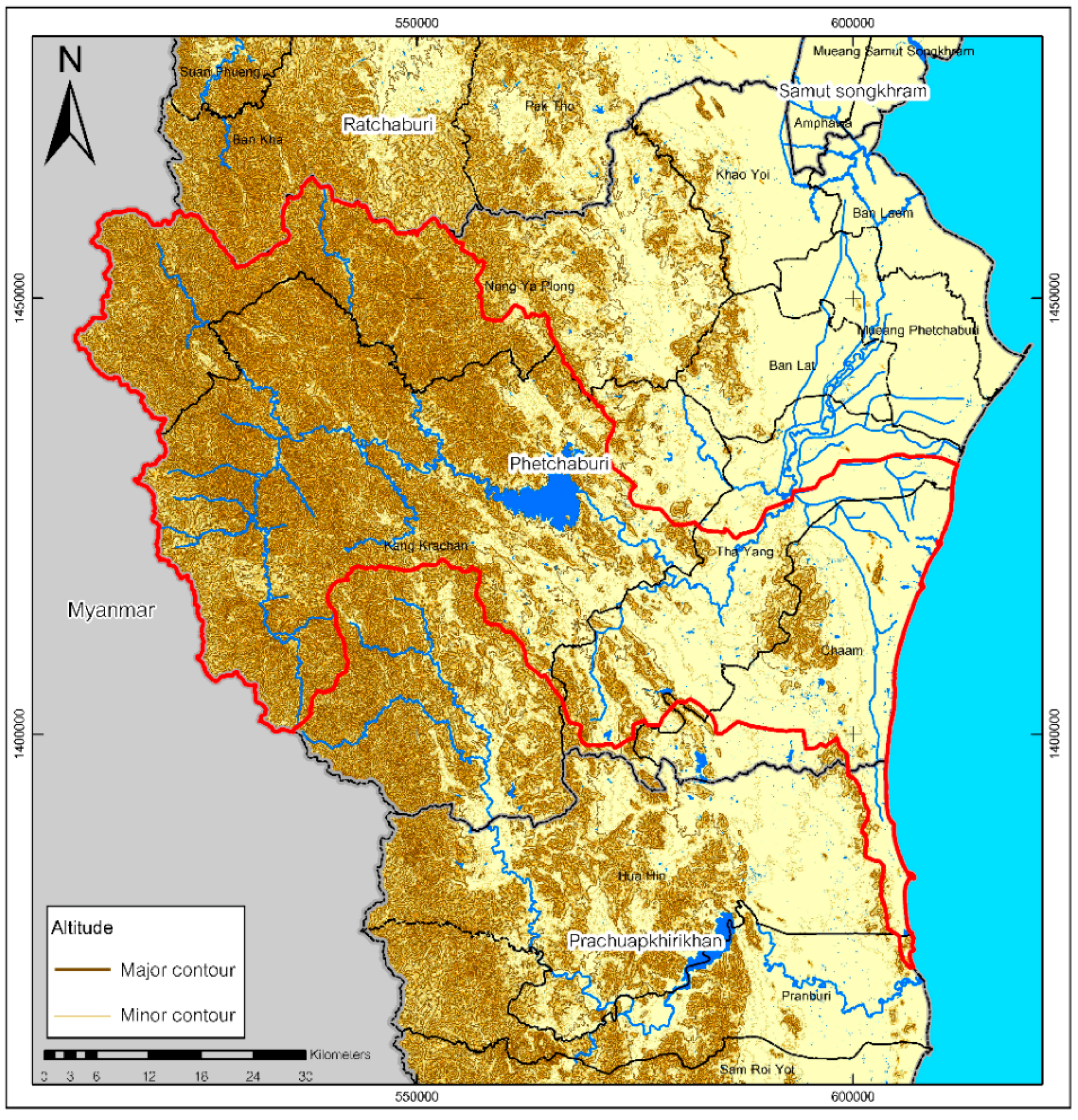
2.1. Study Area
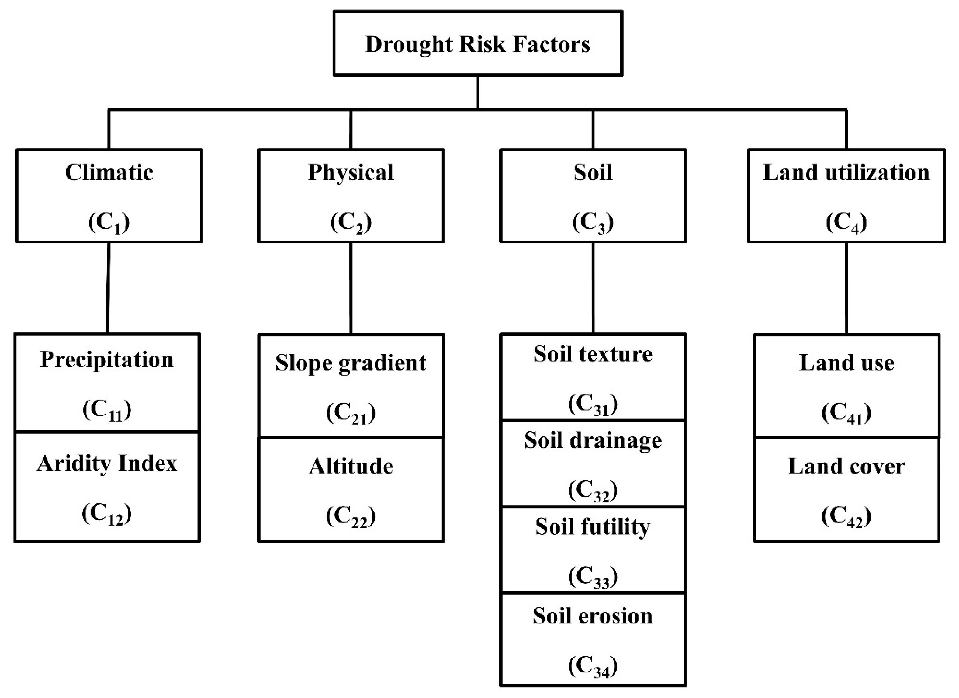
2.2. Data Collecting and Evaluating the Drought Risk Factors
2.3. Concept of Fuzzy Logic and Fuzzy Set Theory
2.4. AHP and Fuzzy Comprehensive Evaluation Model
2.5. Analysis of Drought Risk in the UPRB Using FAHP
3. Results and Discussion
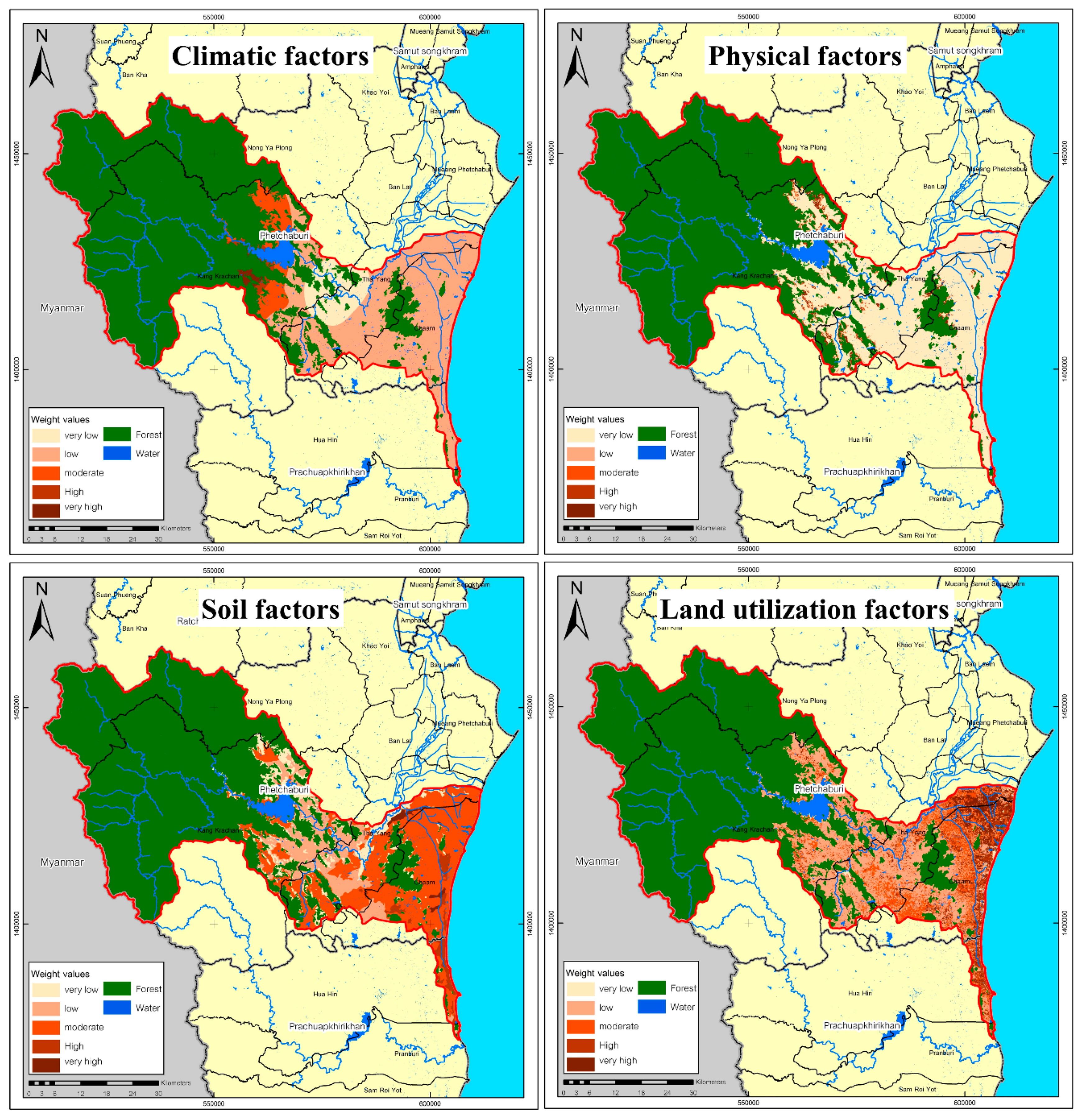
3.1. Factors Affecting Drought Risk in the UPRB
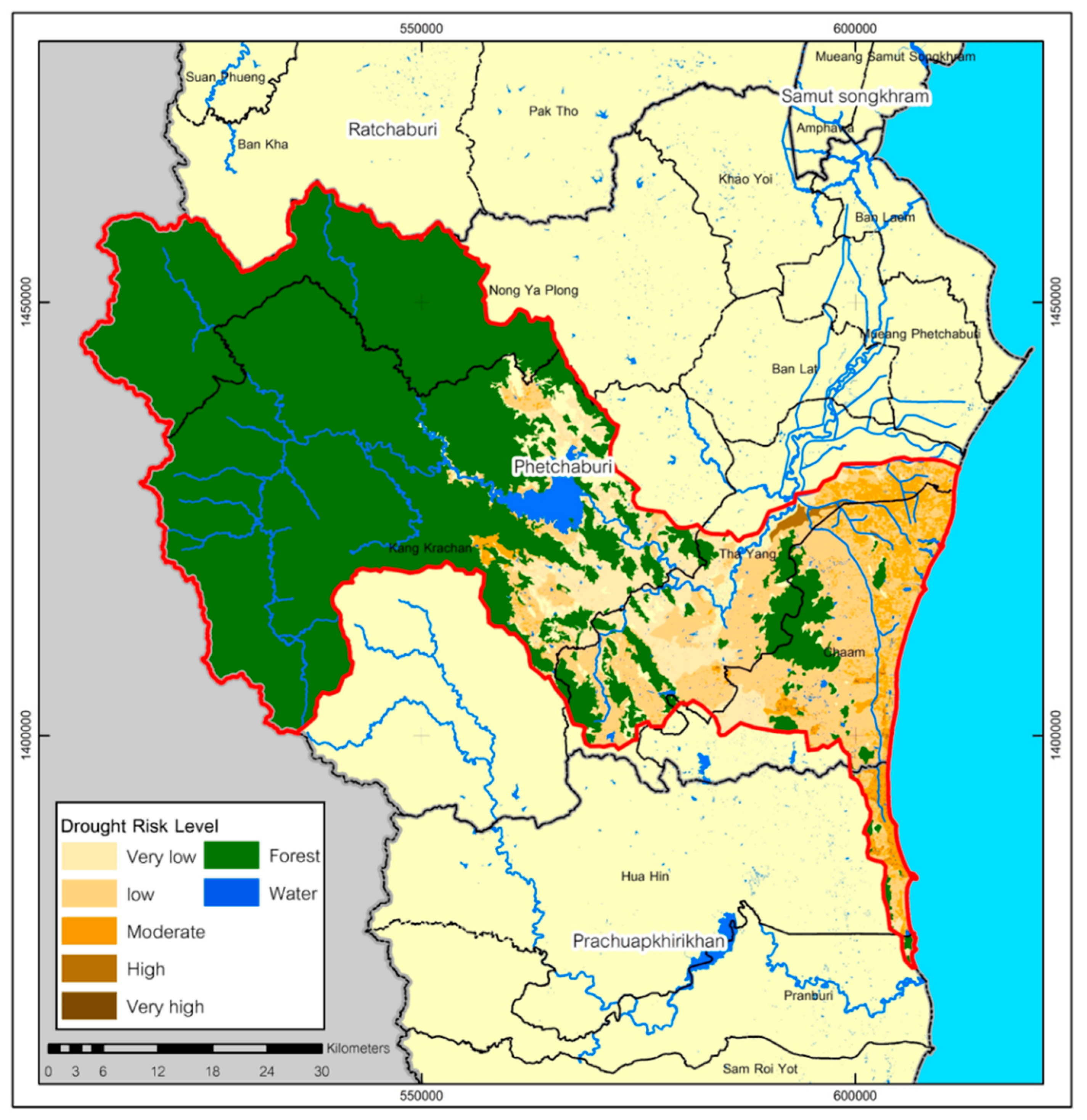
3.2. Areas at Risk of Drought in the UPRB
4. Conclusions and Recommendations
Author Contributions
Funding
Acknowledgments
Conflicts of Interest
References
- Wang, Y.; Xiao, D.; Li, Y.; Li, X. Soil salinity evolution and its relationship with dynamics of groundwater in the oasis of inland river basins, case study from the Fubei region of Xinjiang Province. China J. Environ. Monitor. 2008, 140, 291–302. [Google Scholar] [CrossRef] [PubMed]
- Rangecroft, S.; Birkinshaw, S.; Rohse, M.; Day, R.; McEwen, L.; Makaya, E.; Van Loon, A. Hydrological modelling as a tool for interdisciplinary workshops on future drought. Prog. Phys. Geogr. 2018, 42, 237–256. [Google Scholar] [CrossRef]
- Van Loon, A.F.; Stahl, K.; Di Baldassarre, G.; Clark, J.; Rangecroft, S.; Wanders, N.; Gleeson, T.; Van Dijk, A.I.J.M.; Tallaksen, L.M.; Hannaford, J.; et al. Drought in a human-modified world: Reframing drought definitions, understanding, and analysis approaches. Hydrol. Earth Syst. Sci. 2016, 20, 3631–3650. [Google Scholar] [CrossRef]
- Wijitkosum, S. The impact of land use and spatial changes on desertification risk in degraded areas in Thailand. Sustain. Environ. Res. 2016, 26, 84–92. [Google Scholar] [CrossRef]
- Wijitkosum, S. Critical Factors Affecting the Desertification in Pa Deng, Adjoining Area of Kaeng Krachan National Park, Thailand. Environ. Asia 2014, 7, 87–98. [Google Scholar]
- Santos, F.; Torn, M.S.; Bird, J.A. Biological degradation of pyrogenic organic matter in temperate forest soils. Soil Biol. Biochem. 2012, 51, 115–124. [Google Scholar] [CrossRef]
- Bouabid, R.; Rouchdi, M.; Badraoui, M.; Diab, A.; Louafi, S. Assessment of land desertification based on the MEDALUS approach and elaboration of an action plan: The case study of the Souss River Basin, Morocco. In Land Degradation and Desertification: Assessment, Mitigation and Remediation; Zdruli, P., Pagliai, M., Kapur, S., Cano, A.F., Eds.; Springer: Dordrecht, The Netherlands, 2010; pp. 131–145. [Google Scholar]
- Van Loon, A.F. Hydrological drought explained. WIREs Water 2015, 2, 359–392. [Google Scholar] [CrossRef]
- Diffenbaugh, N.S.; Swain, D.L.; Touma, D. Anthropogenic warming has increased drought risk in California. Proc. Natl. Acad. Sci. USA 2015, 112, 3931–3936. [Google Scholar] [CrossRef] [PubMed]
- Forzieri, G.; Feyen, L.; Rojas, R.; Flörke, M.; Wimmer, F.; Bianchi, A. Ensemble projections of future streamflow droughts in Europe. Hydrol. Earth Syst. Sci. 2014, 18, 85–108. [Google Scholar] [CrossRef]
- Dabanlı, İ.; Mishra, A.K.; Şen, Z. Long-term spatio-temporal drought variability in Turkey. J. Hydrol. 2017, 552, 779–792. [Google Scholar] [CrossRef]
- Liu, X.; Zhu, X.; Pan, Y.; Li, S.; Liu, Y.; Ma, Y. Agricultural drought monitoring: Progress, challenges, and prospects. J. Geogr. Sci. 2016, 26, 750–767. [Google Scholar] [CrossRef]
- Kamali, B.; Kouchi, D.H.; Yang, H.; Abbaspour, K.C. Multilevel Drought Hazard Assessment under Climate Change Scenarios in Semi-Arid Regions—A Case Study of the Karkheh River Basin in Iran. Water 2017, 241, 1–17. [Google Scholar] [CrossRef]
- Kim, J.-M.; Sasaki, T.; Ueda, M.; Sako, K.; Seki, M. Chromatin changes in response to drought, salinity, heat, and cold stresses in plants. Front. Plant Sci. 2015, 6, 114. [Google Scholar] [CrossRef]
- Wada, Y.; Reager, J.T.; Chao, B.F.; Wang, J.; Lo, M.-H.; Song, C.; Li, Y.; Gardner, A.S. Recent Changes in Land Water Storage and its Contribution to Sea Level Variations. Surv. Geophys. 2017, 38, 131–152. [Google Scholar] [CrossRef]
- Masih, I.; Maskey, S.; Mussá, F.E.E.; Trambauer, P. A review of droughts on the African continent: A geospatial and long-term perspective. Hydrol. Earth Syst. Sci. 2014, 18, 3635–3649. [Google Scholar] [CrossRef]
- Wen, L.; Rogers, K.; Ling, J.; Saintilan, N. The impacts of river regulation and water diversion on the hydrological drought characteristics in the Lower Murrumbidgee River, Australia. J. Hydrol. 2011, 405, 382–391. [Google Scholar] [CrossRef]
- Ahmadalipour, A.; Moradkhani, H. Analyzing the uncertainty of ensemble-based gridded observations in land surface simulations and drought assessment. J. Hydrol. 2017, 555, 557–568. [Google Scholar] [CrossRef]
- Srinivasan, V.; Konar, M.; Sivapalan, M. A dynamic framework for water security. Water Secur. 2017, 1, 12–20. [Google Scholar] [CrossRef]
- Wang, L.; Yuan, X.; Xie, Z.; Wu, P.; Li, Y. Increasing flash droughts over China during the recent global warming hiatus. Sci. Rep. 2016, 6, 30571. [Google Scholar] [CrossRef] [PubMed]
- Zadeh, L.A. Fuzzy sets. Inform. Control 1965, 8, 338–353. [Google Scholar] [CrossRef]
- Balezentiene, L.; Streimikiene, D.; Balezentis, T. Fuzzy decision support methodology for sustainable energy crop selection. Renew. Sustain. Energy Rev. 2013, 17, 83–93. [Google Scholar] [CrossRef]
- Wu, Z.; Jina, B.; Xu, J. Local feedback strategy for consensus building with probability-hesitant fuzzy preference relations. Appl. Soft Comput. 2018, 67, 691–705. [Google Scholar] [CrossRef]
- Tian, J.; Yan, F.Z. Fuzzy Analytic Hierarchy Process for Risk Assessment to General assembling of Satellite. J. Appl. Res. Technol. 2013, 11, 568–577. [Google Scholar] [CrossRef]
- Takács, M. Multilevel Fuzzy Approach to the Risk and Disaster Management. Acta Polytechnica Hungarica 2010, 7, 91–102. [Google Scholar]
- Li, D.-F.; Wang, Y.-C.; Liu, S.; Shan, F. Fractional programming methodology for multi-attribute group decision-making using IFS. Appl. Soft Comput. 2009, 9, 219–225. [Google Scholar] [CrossRef]
- Vaidya, O.S.; Kumar, S. Analytic Hierarchy Process: An Overview of Applications. Eur. J. Oper. Res. 2006, 169, 1–29. [Google Scholar] [CrossRef]
- Chang, D.-Y. Applications of the extent analysis method on fuzzy AHP. Eur. J. Oper. Res. 1996, 95, 649–655. [Google Scholar] [CrossRef]
- Zhao, B.; Tang, T.; Ning, B. Applying Hybrid Decision-Making Method Based on Fuzzy AHP-WOWA Operator for Emergency Alternative Evaluation of Unattended Train Operation Metro System. Math. Probl. Eng. 2016, 2016, 4105079. [Google Scholar] [CrossRef]
- Shaw, K.; Shankar, R.; Yadav, S.S.; Thakur, L.S. Supplier selection using fuzzy AHP and fuzzy multi-objective linear programming for developing low carbon supply chain. Expert Syst. Appl. 2012, 39, 8182–8192. [Google Scholar] [CrossRef]
- Hosseini-Moghari, S.-M.; Araghinejad, S.; Azarnivand, A. Fuzzy analytic hierarchy process approach in drought management: Case study of Gorganrood basin, Iran. J. Water Supply Res. Technol. 2017, 66, 207–218. [Google Scholar] [CrossRef]
- Zhao, H.; Yao, L.; Mei, G.; Liu, T.; Ning, Y. A Fuzzy Comprehensive Evaluation Method Based on AHP and Entropy for a Landslide Susceptibility Map. Entropy 2017, 19, 396. [Google Scholar] [CrossRef]
- Verma, S.; Chaudhri, S. Integration of fuzzy reasoning approach (FRA) and fuzzy analytic hierarchy process (FAHP) for risk assessment in mining industry. J. Ind. Eng. Manag. 2014, 7, 1347–1367. [Google Scholar] [CrossRef]
- de Brito, M.; Evers, M. Multi-criteria decision-making for flood risk management: A survey of the current state of the art. Nat. Hazards Earth Syst. Sci. 2016, 16, 1019–1033. [Google Scholar] [CrossRef]
- Zou, Q.; Zhou, J.; Zhou, C.; Song, L.; Guo, J. Comprehensive flood risk assessment based on set pair analysis-variable fuzzy sets model and fuzzy AHP. Stoch. Environ. Res. Risk Assess. 2013, 27, 525–546. [Google Scholar] [CrossRef]
- Thungngern, J.; Sriburi, T.; Wijitkosum, S. Analytic Hierarchy Process for Stakeholder Participation in Integrated Water Resources Management. Eng. J. 2017, 21, 87–103. [Google Scholar] [CrossRef]
- Aminbakhsh, S.; Gunduz, M.; Sonmez, R. Safety risk assessment using analytic hierarchy process (AHP) during planning and budgeting of construction projects. J. Saf. Res. 2013, 46, 99–105. [Google Scholar] [CrossRef] [PubMed]
- Sa-nguansilp, C.; Wijitkosum, S.; Sriprachote, A. Agricultural Drought Risk Assessment in Lam Ta Kong Watershed. Int. J. Geoinf. 2017, 13, 37–43. [Google Scholar]
- Wijitkosum, S. Fuzzy AHP for Drought Risk Assessment in Lam Ta Kong Watershed, the North-eastern Region of Thailand. Soil Water Res. 2018, 13, 218–225. [Google Scholar]
- Papaioannou, G.; Vasiliades, L.; Loukas, A. Multi-Criteria Analysis Framework for Potential Flood Prone Areas Mapping. Water Resour. Manag. 2015, 29, 399–418. [Google Scholar] [CrossRef]
- Aher, P.D.; Adinarayana, J.; Gorantiwar, S.D. Prioritization of watersheds using multi-criteria evaluation through fuzzy analytical hierarchy process. Agric. Eng. Int. CIGR J. 2013, 15, 11–18. [Google Scholar]
- Sadeghravesh, M.H.; Khosravi, H.; Ghasemian, S. Application of fuzzy analytical hierarchy process for assessment of combating-desertification alternatives in central Iran. Nat. Hazards 2014, 75, 653–667. [Google Scholar] [CrossRef]
- Parhizgara, S.M.; Shahidi, A.; Pourreza-Bilondic, M.; Khashei-Siukib, A. Comparison of classic and fuzzy analytic hierarchy processes for mapping the flood hazard of Birjand plain. Water Harvest. Res. 2017, 2, 43–56. [Google Scholar]
- Rahmati, O.; Zeinivand, H.; Besharat, M. Flood hazard zoning in Yasooj region, Iran, using GIS and multi-criteria decision analysis. Geomat. Natl. Hazards Risk 2016, 7, 1000–1017. [Google Scholar] [CrossRef]
- Dehghani, M.; Ghasemi, H.; Malekian, A. Spatial prioritizing of flood reduction and erosion control using fuzzy logic (Case study: Forg Watershed). Rangel. Watershed Manag. J. J. Natl. Resour. Iran. 2014, 66, 28–39. [Google Scholar]
- Mijani, N.; Neysani Samani, N. Comparison of Fuzzy-Based models in landslide hazard mapping. Int. Arch. Photogramm. Remote Sens. Spat. Inf. Sci. 2017, 42, XLII-4/W4. [Google Scholar] [CrossRef]
- Feizizadeh, B.; Roodposhti, M.S.; Jankowski, P.; Blaschke, T. A GIS-based extended fuzzy multi-criteria evaluation for landslide susceptibility mapping. Comput. Geosci. 2014, 73, 208–221. [Google Scholar] [CrossRef] [PubMed]
- Jaafari, A.; Najafi, A.; Pourghasemi, H.R.; Rezaeian, J.; Sattarian, A. GIS-based frequency ratio and index of entropy models for landslide susceptibility assessment in the Caspian forest, northern Iran. Int. J. Environ. Sci. Technol. 2014, 4, 909–926. [Google Scholar] [CrossRef]
- Patel, D.P.; Srivastava, P.K. Flood Hazards Mitigation Analysis Using Remote Sensing and GIS: Correspondence with Town Planning Scheme. Water Resour. Manag. 2013, 27, 2353–2368. [Google Scholar] [CrossRef]
- Pourghasemi, H.R.; Moradi, H.R.; Fatemi Aghda, S.M. Landslide susceptibility mapping by binary logistic regression, analytical hierarchy process, and statistical index models and assessment of their performances. Nat. Hazards 2013, 69, 749–779. [Google Scholar] [CrossRef]
- Haq, M.; Akhtar, M.; Muhammad, S.; Paras, S.; Rahmatullah, J. Techniques of Remote Sensing and GIS for flood monitoring and damage assessment: A case study of Sindh province, Pakistan. Egypt. J. Remote Sens. Space Sci. 2012, 15, 135–141. [Google Scholar] [CrossRef]
- Belal, A.-A.; El-Ramady, H.R.; Mohamed, E.S.; Saleh, A.M. Drought risk assessment using remote sensing and GIS techniques. Arab. J. Geosci. 2014, 7, 35–53. [Google Scholar] [CrossRef]
- Pradhan, B.; Abokharima, M.H.; Jebur, M.N.; Tehrany, M.S. Land subsidence susceptibility mapping at Kinta Valley (Malaysia) using the evidential belief function model in GIS. Nat. Hazards 2014, 73, 1019–1042. [Google Scholar] [CrossRef]
- Chen, W.; Yuan, J.; Li, M. Application of GIS/GPS in Shanghai Airport Pavement Management System. Procedia Eng. 2012, 29, 2322–2326. [Google Scholar] [CrossRef]
- Lin, H.; Chen, M.; Zhang, C.; Hu, M. Virtual Geographic Environments: Feeling it in person and knowing it beyond reality. In Proceedings of the 4th International Conference on Cartography and GIS, Bulgarian Cartographic Association, Albena, Bulgaria, 18–22 June 2012. [Google Scholar]
- Suvachananonda, T. Land Characteristics Affected to Drought of Phetchaburi Province. Master’s Thesis, Mahidol University, Bangkok, Thailand, 2004. [Google Scholar]
- Voravong, S.; Chunkao, K.; Bualert, S. Handling Water through Irrigation Watershed Management for Coping with Stream Pollution Dilution in Phetchaburi River, Thailand. Modern Appl. Sci. 2014, 8, 195–209. [Google Scholar] [CrossRef][Green Version]
- Land Development Department. Kingdom of Thailand National Action Programme for Combating Desertification. Available online: http://www.unccd.int/actionprogrammes/asia/national/2004/thailand-eng.pdf (accessed on 23 October 2018).
- UNISDR. Drought Risk Reduction Framework and Practices: Contributing to the Implementation of the Hyogo Framework for Action; United Nations secretariat of the International Strategy for Disaster Reduction (UNISDR): Geneva, Switzerland, 2009. [Google Scholar]
- Panagoulia, D.G.; Dimou, D. Climatic instability and low-flow regimes. In Proceedings of the Water Resources Management under Drought or Water Shortage Conditions, EWRA 95 Symposium, Nicosia, Cyprus, 14–18 March 1995; Tsiourtis, N.X., Ed.; EWRA by A.A. Balkema: Rotterdam, The Netherlands, 1995; pp. 29–34. [Google Scholar]
- Dionysia, P.; Dimou, G. Definition and effects of droughts. In Proceedings of the Conference on Mediterranean Water Policy: Building on Existing Experience, Mediterranea Water Network, Valencia, Spain, 12–15 June 1998. [Google Scholar]
- Valipour, M. Use of surface water supply index to assessing of water resources management in Colorado and Oregon, US. Adv. Agric. Sci. Eng. Res. 2013, 3, 631–640. [Google Scholar]
- Kwon, H.-J.; Kim, S.-J. Assessment of distributed hydrological drought based on hydrological unit map using SWSI drought index in South Korea. KSCE J. Civ. Eng. 2010, 14, 923–929. [Google Scholar] [CrossRef]
- FAO. The ETo Calculator: Evapotranspiration from a Reference Surface; Food and Agriculture Organization of the United Nations: Rome, Italy, 2009. [Google Scholar]
- Wijitkosum, S. The Relationship between climatic factors and forest area case study: Huay Sai Royal development study center, Petchaburi province, Thailand. J. Environ. Res. Dev. 2011, 5, 1010–1016. [Google Scholar]
- Yang, Z.-B.; Eticha, D.; Albacete, A.; Rao, I.M.; Roitsch, T.; Horst, W.J. Physiological and molecular analysis of the interaction between aluminium toxicity and drought stress in common bean (Phaseolus vulgaris). J. Exp. Bot. 2012, 63, 3109–3125. [Google Scholar] [CrossRef] [PubMed]
- Fang, L.; Hain, C.R.; Zhan, X.; Andersonc, M.C. An inter-comparison of soil moisture data products from satellite remote sensing and a land surface model. Int. J. Appl. Earth Obs. Geoinf. 2016, 48, 37–50. [Google Scholar] [CrossRef]
- Gomiero, T. Soil Degradation, Land Scarcity and Food Security: Reviewing a Complex Challenge. Sustainability 2016, 8, 281. [Google Scholar] [CrossRef]
- Posthumus, H.; Deeks, L.K.; Rickson, R.J.; Quinton, J.N. Costs and benefits of erosion control measures in the UK. Soil Use Manag. 2015, 31, 16–33. [Google Scholar] [CrossRef]
- Gutiérrez-Vélez, V.H.; Uriarte, M.; DeFries, R.; Pinedo-Vásquez, M.; Fernandes, K.; Ceccato, P.; Baethgen, W.; Padoch, C. Land cover change interacts with drought severity to change fire regimes in Western Amazonia. Ecol. Appl. 2014, 24, 1323–1340. [Google Scholar] [CrossRef] [PubMed]
- Zhao, C.; Deng, X.; Yuan, Y.; Yan, H.; Liang, H. Prediction of Drought Risk Based on the WRF Model in Yunnan Province of China. Adv. Meteorol. 2013, 2013, 295856. [Google Scholar] [CrossRef]
- Pimentel, D.; Burgess, M. Soil Erosion Threatens Food Production. Agriculture 2013, 3, 443–463. [Google Scholar] [CrossRef]
- Wijitkosum, S. Impacts of land use changes on soil erosion in Pa Deng sub-district, adjacent area of Kaeng Krachan National Park, Thailand. Soil Water Res. 2012, 7, 10–17. [Google Scholar] [CrossRef]
- Bachmair, S.; Stahl, K.; Collins, K.; Hannaford, J.; Acreman, M.; Svoboda, M.; Knutson, C.; Helm Smith, K.; Wall, N.; Fuchs, B.; et al. Drought indicators revisited: The need for a wider consideration of environment and society. WIREs Water 2016, 3, 516–536. [Google Scholar] [CrossRef]
- Lorenzo-Lacruz, J.; Morán-Tejeda, E.; Vicente-Serrano, S.M.; López-Moreno, J.I. Streamflow droughts in the Iberian Peninsula between 1945 and 2005: Spatial and temporal patterns. Hydrol. Earth Syst. Sci. 2013, 17, 119–134. [Google Scholar] [CrossRef]
- Novara, A.; Sarno, M.; Pereira, P.; Cerdà, A.; Brevik, E.C.; Gristina, L. Straw uses trade-off only after soil organic carbon steady-state. Ital. J. Agron. 2018, 13, 216–220. [Google Scholar] [CrossRef]
- Land Development Department. Soil Erosion in Thailand; Land Development Department: Bangkok, Thailand, 2000. [Google Scholar]
- Bagley, J.E.; Desai, A.R.; Harding, K.J.; Snyder, P.K.; Foley, J.A. Drought and deforestation: Has land cover change influenced recent precipitation extremes in the Amazon? J. Clim. 2014, 27, 345–361. [Google Scholar] [CrossRef]
- Mokhtari, A.; Mansor, S.B.; Mahmud, A.R.; Helmi, Z.M. Monitoring the Impacts of Drought on Land Use/Cover: A Developed Object-based Algorithm for NOAA AVHRR Time Series Data. J. Appl. Sci. 2011, 11, 3089–3103. [Google Scholar] [CrossRef]
- Obojes, N.; Bahn, M.; Tasser, E.; Walde, J.; Inauen, N.; Hiltbrunner, E.; Saccone, P.; Lochet, J.; Clement, J.C.; Lavorel, S.; et al. Vegetation effects on the water balance of mountain grasslands depend on climatic conditions. Ecohydrology 2015, 8, 552–569. [Google Scholar] [CrossRef]
- Kubler, S.; Robert, J.; Derigent, W.; Voisin, A.; Traon, Y.L. A state-of the-art survey & testbed of fuzzy AHP (FAHP) applications. Expert Syst. Appl. 2016, 65, 398–422. [Google Scholar]
- Tseng, M.L.; Chiang, J.H.; Lan, L.W. Selection of optimal supplier in supply chain management strategy with analytic network process and choquet integral. Comput. Ind. Eng. 2009, 57, 330–340. [Google Scholar] [CrossRef]
- Dinh, L.C.; Duc, T.T. GIS and Analytic Hierarchy Process for Land Evaluation. Available online: http://docplayer.net/14799069-Gis-and-analytic-hierarchy-process-for-land-evaluation.html (accessed on 24 October 2018).
- Kabir, G.; Hasin, A.A.M. Comparative analysis Of AHP and fuzzy AHP models for multicriteria inventory classification. Int. J. Fuzzy Logic Syst. 2011, 11, 1–16. [Google Scholar]
- Zhu, K.J.; Jing, Y.; Chang, D.Y. A Discussion on Extent Analysis Method and Applications of Fuzzy AHP. Eur. J. Oper. Res. 1999, 116, 450–456. [Google Scholar] [CrossRef]
- Nazam, M.; Xu, J.; Tao, Z.; Ahmad, J.; Hashim, M. A fuzzy AHP-TOPSIS framework for the risk assessment of green supply chain implementation in the textile industry. Int. J. Supply Oper. Manag. 2015, 2, 548–568. [Google Scholar]
- Wei, W.; Xu, L.; Zhou, Z. Research and Design on Fuzzy-based Cluster Model. AASRI Procedia 2012, 1, 92–99. [Google Scholar] [CrossRef]
- Liu, H.-W.; Wang, G.-J. Multi-criteria decision-making methods based on intuitionistic fuzzy sets. Eur. J. Oper. Res. 2007, 179, 220–233. [Google Scholar] [CrossRef]
- Khazaeni, G.; Khanzadi, M.; Afshar, A. Optimum risk allocation model for construction contracts: Fuzzy TOPSIS approach. Can. J. Civ. Eng. 2012, 39, 789–800. [Google Scholar] [CrossRef]
- Saaty, T.L. The Analytic Hierarchy Process; McGraw-Hill: New York, NY, USA, 1980. [Google Scholar]
- Saaty, T.L.; Vargas, L.G. Models, Methods, Concepts & Applications of the Analytic Hierarchy Process; Springer Science & Business Media: New York, NY, USA, 2012. [Google Scholar]
- Erden, T.; Karaman, H. Analysis of earthquake parameters to generate hazard maps by integrating AHP and GIS for Küçükçekmece region. Nat. Hazards Earth Syst. Sci. 2012, 12, 475–483. [Google Scholar] [CrossRef]
- Pourghasemi, H.R.; Pradhan, B.; Gokceoglu, C. Application of fuzzy logic and analytical hierarchy process (AHP) to landslide susceptibility mapping at Haraz watershed, Iran. Nat. Hazards. 2012, 63, 1–32. [Google Scholar] [CrossRef]
- Wang, Y.; Li, Z.; Tang, Z.; Zeng, G. A GIS-Based Spatial Multi-Criteria Approach for Flood Risk Assessment in the Dongting Lake Region, Hunan, Central China. Water Resour. Manag. 2011, 25, 3465–3484. [Google Scholar] [CrossRef]
- Wang, Y.M. Centroid defuzzification and the maximizing set and minimizing set ranking based on alpha level sets. Comput. Ind. Eng. 2009, 57, 228–236. [Google Scholar] [CrossRef]
- Yager, R.; Filev, D. Template-based fuzzy system modeling. J. Intell. Fuzzy. Syst. 1994, 2, 39–54. [Google Scholar]
- Uehara, K.; Hirota, K. Parallel and multistage fuzzy inference based on families of α-level sets. Int. J. Inf. Sci. 1998, 106, 159–195. [Google Scholar] [CrossRef]
- Wang, W.-J.; Luoh, L. Simple Computation of the Defuzzifications of Center of Sum and Center of Gravity. J. Intell. Fuzzy. Syst. 2000, 9, 53–59. [Google Scholar]
- Alila, Y.; Kuras´, P.K.; Schnorbus, M.; Hudson, R. Forests and floods: A new paradigm sheds light on age-old controversies. Water Resour. Res. 2009, 45, 1–24. [Google Scholar] [CrossRef]
- Center for International Forestry Research. Forests and Floods Drowning in Fiction or Thriving on Facts? Center for International Forestry Research, Food and Agriculture Organization of the United Nations: Bogor Barat, Indonesia, 2005. [Google Scholar]
- Bruijnzeel, L.A. Hydrological functions of tropical forests: Not seeing the soil for the trees? Agric. Ecosyst. Environ. 2004, 104, 185–228. [Google Scholar] [CrossRef]
- Ingrisch, J.; Karlowsky, S.; Anadon-Rosell, A.; Hasibeder, R.; König, A.; Augusti, A.; Gleixner, G.; Bahn, M. Land Use Alters the Drought Responses of Productivity and CO2 Fluxes in Mountain Grassland. Ecosystems 2018, 21, 689–703. [Google Scholar] [CrossRef]
- Jing, J.; Bezemer, T.M.; Van der Putten, W.H. Interspecific competition of early successional plant species in ex-arable fields as influenced by plant–soil feedback. Basic Appl. Ecol. 2015, 16, 112–119. [Google Scholar] [CrossRef]
- Pimentel, D. Soil Erosion: A Food and Environmental Threat. Environ. Dev. Sustain. 2006, 8, 119–137. [Google Scholar] [CrossRef]
- Cheng, L.; Hoerling, M.; Aghakouchak, A.; Livneh, B.; Quan, X.-W.; Eischeid, J. How has human-induced climate change affected California drought risk? J. Clim. 2016, 29, 111–120. [Google Scholar] [CrossRef]
- Fang, H.; Jiang, C.; Li, W.; Wei, S.; Baret, F.; Chen, J.M.; Garcia-Haro, J.; Liang, S.; Liu, R.; Myneni, R.B.; et al. Characterization and intercomparison of global moderate resolution leaf area index (LAI) products: Analysis of climatologies and theoretical uncertainties. J. Geophys. Res. Biogeosci. 2013, 118, 529–548. [Google Scholar] [CrossRef]
- Su, Z.-A.; Zhang, J.-H.; Nie, X.-J. Effect of Soil Erosion on Soil Properties and Crop Yields on Slopes in the Sichuan Basin, China. Pedosphere 2010, 20, 736–746. [Google Scholar] [CrossRef]
- Zhou, P.; Luukkanen, O.; Tokola, T.; Nieminen, J. Effect of vegetation cover on soil erosion in a mountainous watershed. Catena 2008, 75, 319–325. [Google Scholar] [CrossRef]


| Fuzzy Numbers | Linguistic Variable |
|---|---|
| 1̃ | Equally importance |
| 3̃ | Moderately importance |
| 5̃ | Strongly importance |
| 7̃ | Very strongly importance |
| 9̃ | Extremely importance |
| 2̃, 4̃, 6̃, 8̃ | Intermediate values between adjacent scale values |
| n | 1 | 2 | 3 | 4 | 5 | 6 | 7 | 8 | 9 | 10 | 11 | 12 | 13 | 14 | 15 |
|---|---|---|---|---|---|---|---|---|---|---|---|---|---|---|---|
| RI | 0.00 | 0.00 | 0.58 | 0.90 | 1.12 | 1.24 | 1.32 | 1.41 | 1.45 | 1.49 | 1.51 | 1.48 | 1.56 | 1.57 | 1.59 |
| Intensity of Importance | Fuzzy Number | Linguistic Variable | TFNs (l, m, n) | Reciprocal of Fuzzy Values (1/u,1/m,1/l) |
|---|---|---|---|---|
| 1 3 5 7 9 2, 4, 6, 8 | 1̃ 3̃ 5̃ 7̃ 9̃ | Equally important Weekly important Strongly important Very strongly important Extremely more important The median of the above adjacent judgement | (1, 1, 2) (2, 3, 4) (4, 5, 6) (6, 7, 8) (8, 9, 9) (x − 1, x, x + 1; x = 2, 4, 6, 8) | (0.33, 1.00, 1.00) (0.20, 0.33, 1.00) (0.14, 0.20, 0.33) (0.11, 0.14, 0.20) (0.09, 0.11, 0.14) (1/(x + 1), 1/x, 1/(x − 1); x = 2, 4, 6, 8) |
| Factors/Criterion | Priority of Criterion | Sub-Criterion | Priority of Sub-Criterion | Final Priority of Sub-Criterion |
|---|---|---|---|---|
| C1 | 0.4425 | C11 | 0.7461 | 0.3301493 |
| C12 | 0.2539 | 0.1123508 | ||
| C2 | 0.0790 | C21 | 0.7461 | 0.0589419 |
| C22 | 0.2539 | 0.0200581 | ||
| C3 | 0.2916 | C31 | 0.1363 | 0.0397451 |
| C32 | 0.3498 | 0.1020017 | ||
| C33 | 0.1211 | 0.0353128 | ||
| C34 | 0.3928 | 0.1145405 | ||
| C4 | 0.1868 | C41 | 0.5588 | 0.1043838 |
| C42 | 0.4412 | 0.0824162 |
© 2019 by the authors. Licensee MDPI, Basel, Switzerland. This article is an open access article distributed under the terms and conditions of the Creative Commons Attribution (CC BY) license (http://creativecommons.org/licenses/by/4.0/).
Share and Cite
Wijitkosum, S.; Sriburi, T. Fuzzy AHP Integrated with GIS Analyses for Drought Risk Assessment: A Case Study from Upper Phetchaburi River Basin, Thailand. Water 2019, 11, 939. https://doi.org/10.3390/w11050939
Wijitkosum S, Sriburi T. Fuzzy AHP Integrated with GIS Analyses for Drought Risk Assessment: A Case Study from Upper Phetchaburi River Basin, Thailand. Water. 2019; 11(5):939. https://doi.org/10.3390/w11050939
Chicago/Turabian StyleWijitkosum, Saowanee, and Thavivongse Sriburi. 2019. "Fuzzy AHP Integrated with GIS Analyses for Drought Risk Assessment: A Case Study from Upper Phetchaburi River Basin, Thailand" Water 11, no. 5: 939. https://doi.org/10.3390/w11050939
APA StyleWijitkosum, S., & Sriburi, T. (2019). Fuzzy AHP Integrated with GIS Analyses for Drought Risk Assessment: A Case Study from Upper Phetchaburi River Basin, Thailand. Water, 11(5), 939. https://doi.org/10.3390/w11050939