The Development and Application of the Urban Flood Risk Assessment Model for Reflecting upon Urban Planning Elements
Abstract
:1. Introduction
2. Methods
2.1. Vulnerability and Exposure of Urban Flood
2.2. Risk of Urban Flood
2.3. Relationship between Urban Space and Flooding
2.4. Methods of Risk Analysis
- 1)
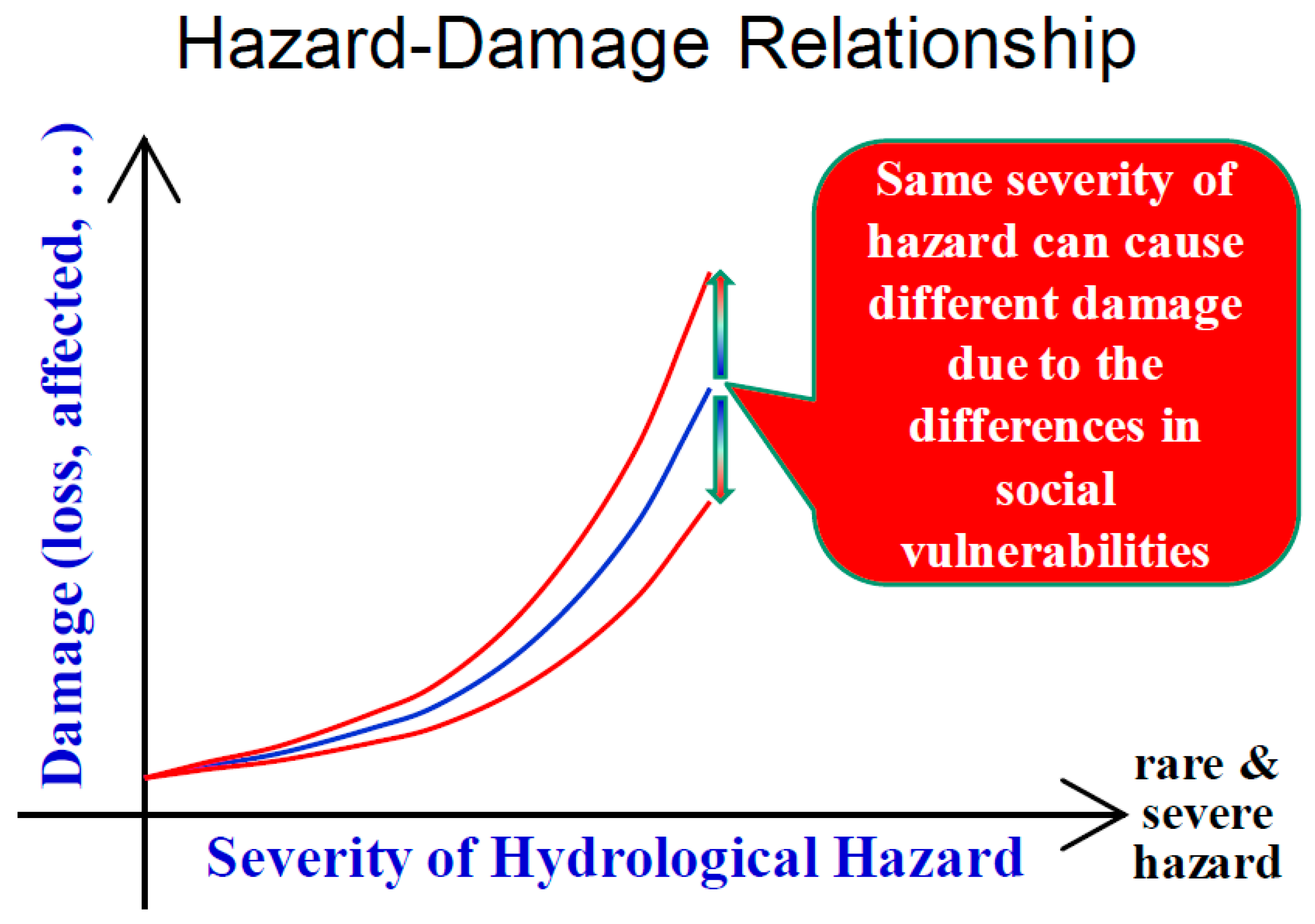
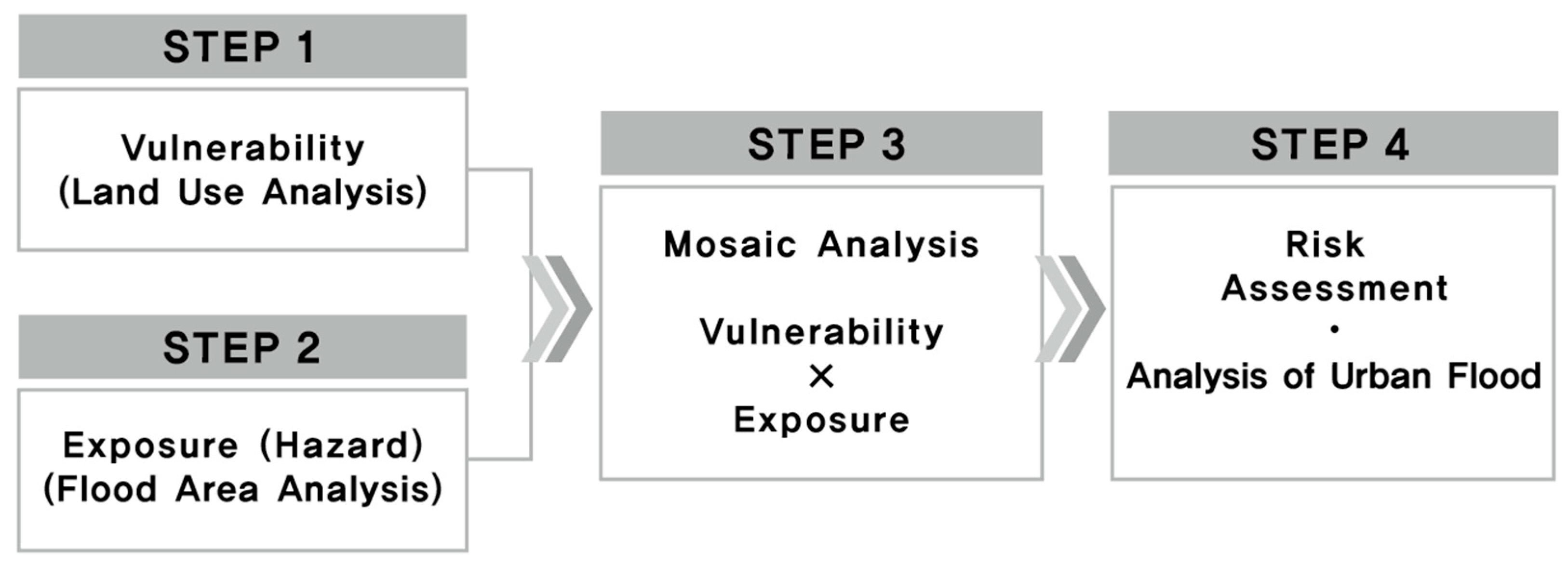
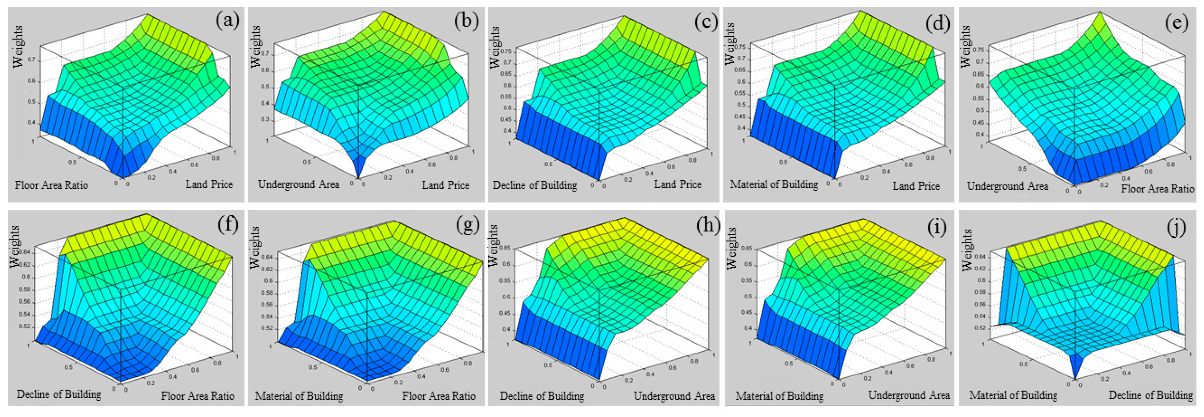
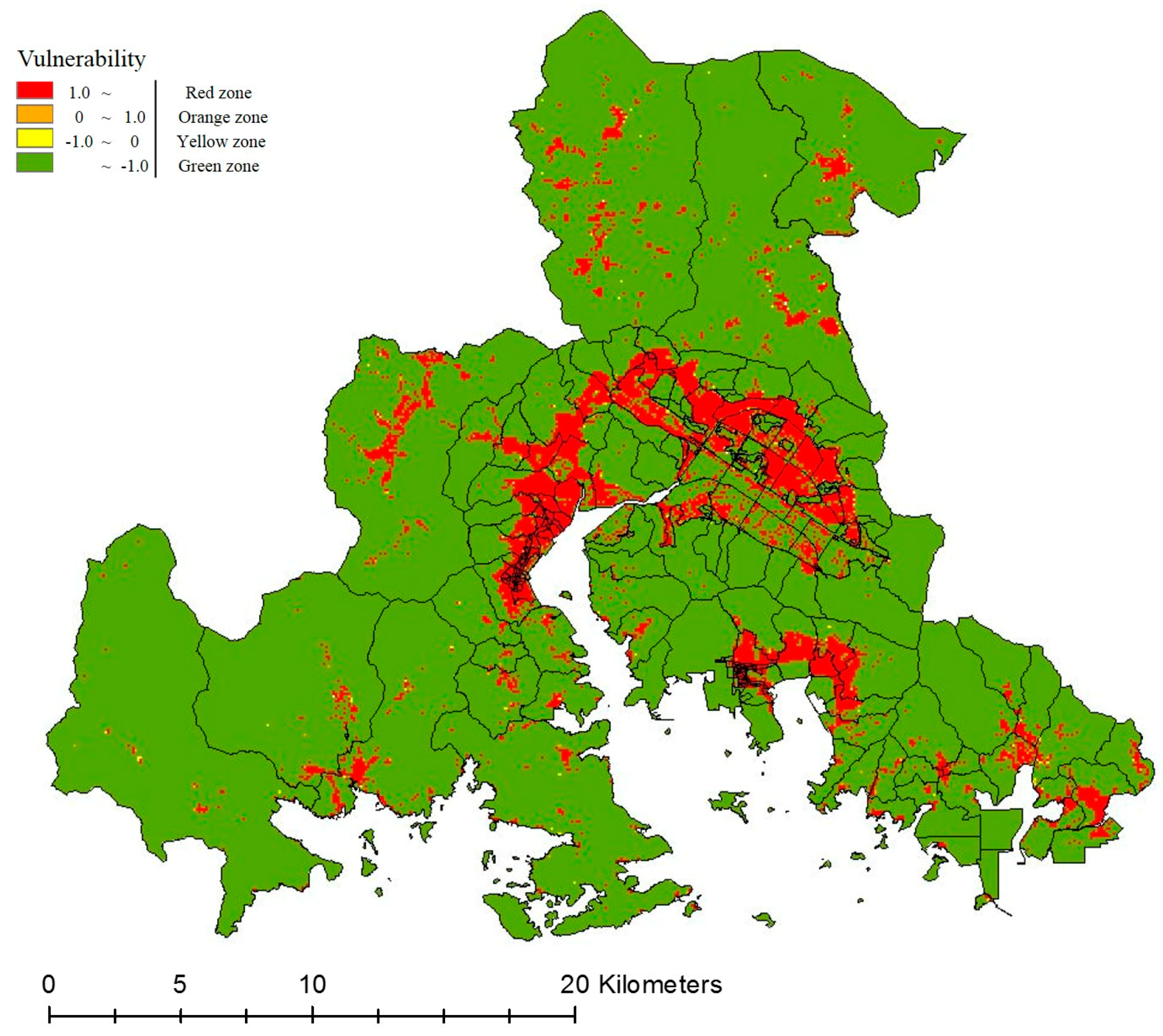
- Vulnerability analysis: Vulnerability is the result of external stress, which implies an internal condition of urban areas. It is the degree of socio-economic damage to the urban space (land use) and building characteristics (land price, floor area ratio, underground area, decline of building, material of building) during flooding.
- 2)
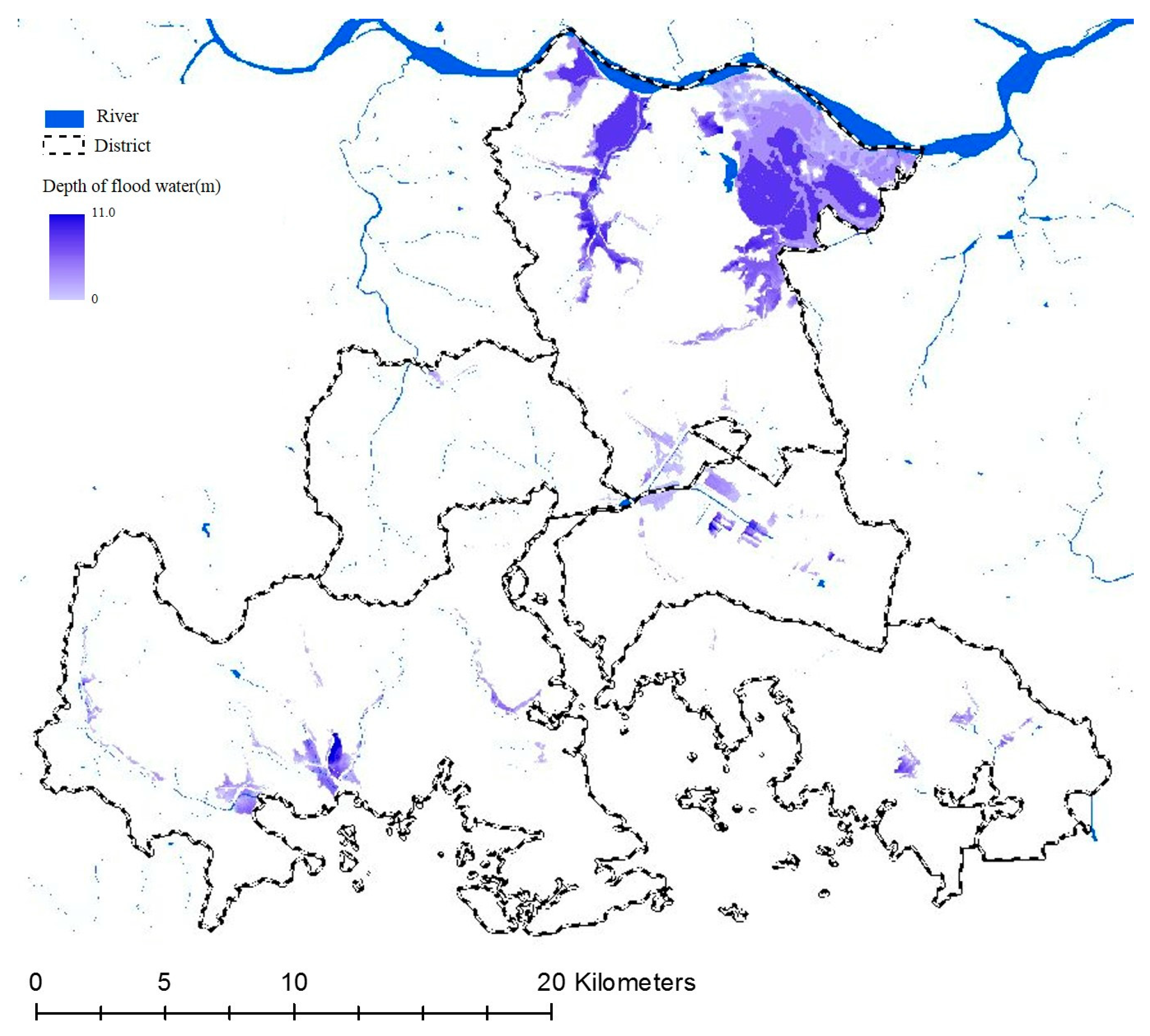
- Exposure (Hazard) analysis: An empirical analysis is of the flood depth, and flooding area was conducted considering the environmental factors, such as rainfall and topography. It is frequently referred to as an “inundation trace map”, which is the result of an urban flooding map.
- 3)
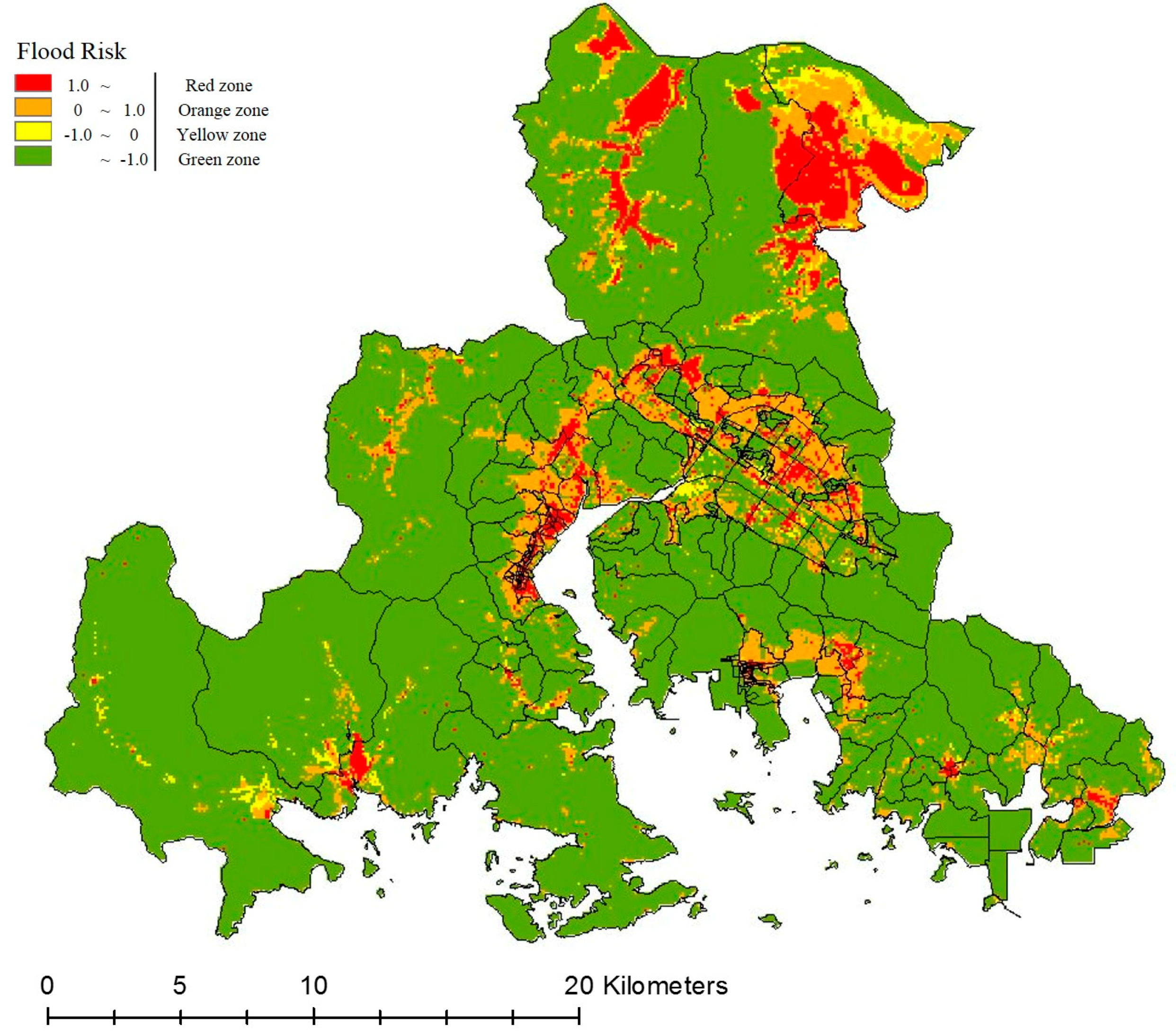
- Flood risk analysis: This established the flood risk evaluation model analysis system by reflecting on the land use and building characteristics which are included in the non-structural measures to perform evaluation and analysis. Flood risk was calculated by deriving a value from each grid and overlapping it with the map by considering the vulnerability data, which classified the risk in each grid unit, and the analysis data for flooded areas, such as disaster characteristics, were employed as a function.
- 4)
- Urban flood risk assessment: Areas with high and low risks were determined by objective and scientific methods based on the urban flood risk assessment. Finally, the intent was to establish a long-term measure by setting the flood risk area based on the results analyzed by these objective and scientific methods.
2.5. Evaluation Item
2.6. Fuzzy Classification
2.7. Analysis Area
3. Results and Discussion
3.1. Analysis of Vulnerability
3.2. Analysis of Exposure
3.3. Analysis of Risk
3.4. Overall Analysis Results
4. Conclusions
Author Contributions
Acknowledgments
Conflicts of Interest
References
- Chang, L.C.; Chang, F.J.; Yang, S.N.; Kao, I.F.; Ku, Y.Y.; Kuo, C.L.; bin Mat Amin, I.M.Z. Building an Intelligent Hydroinformatics Integration Platform for Regional Flood Inundation Warning Systems. Water 2019, 11, 9. [Google Scholar] [CrossRef]
- Lytle, D.A.; Poff, N.L. Adaptation to natural flow regimes. Trends Ecol. Evol. 2004, 19, 94–100. [Google Scholar] [CrossRef] [PubMed]
- Tockner, K.; Lorang, M.; Stanford, J.A. River flood plains are model ecosystems to test general hydrogeomorphic and ecological concepts. River Res. Appl. 2010, 86, 76–86. [Google Scholar] [CrossRef]
- Miguez, M.G.; Veról, A.P.; de Sousa, M.M.; Rezende, O.M. Urban Floods in Lowlands—Levee Systems, Unplanned Urban Growth and River Restoration Alternative: A Case Study in Brazil. Sustainability 2015, 7, 11068–11097. [Google Scholar] [CrossRef]
- Tingsanchali, T. Urban flood disaster management. Procedia Eng. 2012, 32, 25–37. [Google Scholar] [CrossRef]
- Walsh, R.; Davies, H.; Musa, S. Flood frequency and impacts at Khartoum since the early nineteenth century. Geogr. J. 1994, 160, 266–279. [Google Scholar] [CrossRef]
- Zevenbergen, C.; Veerbeek, W.; Gersonius, B.; van Herk, S. Challenges in urban flood management: Travelling across spatial and temporal scales. J. Flood Risk Manag. 2008, 1, 81–88. [Google Scholar] [CrossRef]
- Liao, K.; Le, T.A.; van Nguyen, K. Urban design principles for flood resilience: Learning from the ecological wisdom of living with floods in the Vietnamese Mekong Delta. Landsc. Urban Plan. 2016, 155, 69–78. [Google Scholar] [CrossRef]
- Dihn, Q.; Balica, S.; Popescu, I.; Jonoski, A. Climate change impact on flood hazard, vulnerability and risk of the Long Xuyen Quadrangle in the Mekong Delta. Int. J. River Basin Manag. 2012, 10, 103–120. [Google Scholar]
- Selenica, A.; Kuriqi, A.; Ardicioglu, M. Risk assessment from floodings in the rivers of albania. In Proceedings of the International Balkans Conference on Challenges of Civil Engineering, Tirana, Albania, 23–25 May 2013. [Google Scholar]
- Kang, L.; Jiang, S.; Hu, X.; Li, C. Evaluation of Return Period and Risk in Bivariate Non-Stationary Flood Frequency Analysis. Water 2019, 11, 79. [Google Scholar] [CrossRef]
- Adhikari, P.; Hong, Y.; Douglas, K.R.; Kirschbaum, D.B.; Gourley, J.; Adler, R.; Robert Brakenridge, G. A digitized global flood inventory (1998–2008): Compilation and preliminary results. Nat. Hazards 2010, 55, 405–422. [Google Scholar] [CrossRef]
- Güneralp, B.; Güneralp, I.; Liu, Y. Changing global patterns of urban exposure to flood and drought hazards. Glob. Environ. Chang. 2015, 31, 217–225. [Google Scholar] [CrossRef]
- Eissa, A.E.; Zaki, M.M. The impact of global climatic changes on the aquatic environment. Procedia Environ. Sci. 2011, 4, 251–259. [Google Scholar] [CrossRef]
- Broekx, S.; Smets, S.; Liekens, I.; Bulckaen, D.; de Nocker, L. Designing a long-term flood risk management plan for the Scheldt estuary using a risk-based approach. Nat. Hazards 2011, 57, 245–266. [Google Scholar] [CrossRef]
- Yin, J.; Ye, M.; Yin, Z.; Xu, S. A review of advances in urban flood risk analysis over China. Stoch. Environ. Res. Risk Assess. 2015, 29, 1063–1070. [Google Scholar] [CrossRef]
- Zope, P.E.; Eldho, T.I.; Jothiprakash, V. Impacts of urbanization on flooding of a coastal urban catchment: A case study of Mumbai City, India. Nat. Hazards 2014, 75, 887–908. [Google Scholar] [CrossRef]
- Garcia, E.; Loáiciga, H. Sea-level rise and flooding in coastal riverine flood plains. Hydrol. Sci. J. 2014, 37–41. [Google Scholar] [CrossRef]
- Kim, H.; Lee, D.; Sung, S. Effect of Urban Green Spaces and Flooded Area Type on Flooding Probability. Sustainability 2016, 8, 134. [Google Scholar] [CrossRef]
- Liu, W.; Chen, W.; Peng, C. Assessing the effectiveness of green infrastructures on urban flooding reduction: A community scale study. Ecol. Model. 2014, 291, 6–14. [Google Scholar] [CrossRef]
- Gaur, A.; Gaur, A.; Yamazaki, D.; Simonovic, S.P. Flooding Related Consequences of Climate Change on Canadian Cities and Flow Regulation Infrastructure. Water 2019, 11, 63. [Google Scholar] [CrossRef]
- Intergovernmental Panel on Climate Change (IPCC). Climate Change 2007: Impact, Adaptation and Vulnerability, Fourth Assessment Report; Cambridge University Press: Cambridge, UK, 2007. [Google Scholar]
- Moss, R.H.; Brenkert, A.L.; Malone, E.L. Vulnerability to Climate Change; U.S. Department of Energy: Oak Ridge, TN, USA, 2001.
- The United Nations Educational, Scientific and Cultural Organization (UNESCO). International Hydrological Programme (IHP), Water Security: Responses to Local, Regional, and Global Challenges, Strategic Plan VIII (2014–2021); United Nations Educational, Scientific and Cultural Oranization: Paris, France, 2013. [Google Scholar]
- Mehr, R.I.; Hedges, B.A. Risk Management: Concepts and Applications; Richard Irwin Inc.: Homewood, CA, USA, 1974. [Google Scholar]
- Shin, S.Y.; Kim, H.R. Analyzing Relationships between Land Use Characteristics and Flood Damage Areas; Seoul Development Institute: Seoul, Korea, 2011. [Google Scholar]
- Burton, I.; Kates, R.W.; White, G.F. The Environment as Hazard, 2nd ed.; The Guilford Press: New York, NY, USA, 1993. [Google Scholar]
- Norman, B. Principles for an Intergovernmental Agreement for Coastal Planning and Climate Change in Australia. Habitat Int. 2008, 33, 293–299. [Google Scholar] [CrossRef]
- United Nations Environment Programme (UNEP). Mainstreaming Climate Change Adaptation into Development Planning: A Guide for Practitioners; UNEP: Nairobi, Kenya, 2012. [Google Scholar]
- Hideki, K. Urban Disaster Prevention. Tokyo, Japan, 2011. Available online: https://www.urd.org/IMG/pdf/Urban_Preparedness_Kathmandu_Full_Report_.pdf (accessed on 7 May 2019).
- Park, K.Y.; Lee, M.H. Vulnerability analysis of urban district on the urban flood damage: A case study Changwon. Desalin. Water Treat. 2018, 119, 27–35. [Google Scholar] [CrossRef]
- Lee, C.H. Development of the Regional Safety Assesment Model in Seoul-Focusing on Flood; Seoul Development Institute: Seoul, Korea, 2006; pp. 1–130. [Google Scholar]
- Han, H. Climate Change Impact Assessment and Development of Adaptation Strategies in Korea; Korea Environment Institute: Sejong, Korea, 2007; pp. 1–417. [Google Scholar]
- Park, H. Disaster Site Investigation and Disaster Prevention Planning Standard Establishment for Urban Space and Facilities; National Disaster Management Research Institute: Ulsan, Korea, 2010; pp. 1–371. [Google Scholar]
- Jang, M.S. Vulnerability Analysis of Building Inundation caused by Storm Surge in Masan Bay. Master’s Dissertation, Sungkyunkwan University, Seoul, South Korea, 2015; pp. 1–55. [Google Scholar]
- Unanwa, C.O.; McDonald, J.R.; Mehta, K.C.; Smith, D.A. The Development of Wind Damage Bands for Buildings. J. Wind Eng. Ind. Aerodyn. 2000, 84, 119–149. [Google Scholar] [CrossRef]
- Zadeh, L.A. Fuzzy sets. Inf. Control 1965, 8, 338–353. [Google Scholar] [CrossRef]
- Chang, N.; Chen, H.W.; Ning, S.K. Identification of river water quality using the Fuzzy Synthetic Evaluation approach. J. Environ. Manag. 2001, 63, 293–305. [Google Scholar] [CrossRef] [PubMed]
- Gopal, S.; Woodcock, C. Remote sensing of forest change using artificial neural networks. IEEE Trans. Geosci. Remote Sens. 1996, 34, 398–404. [Google Scholar] [CrossRef]
- Curlander, J.; Kober, W. Rule Based System for Thematic Classification in SAR Imagery. In Proceedings of the International Geoscience and Remote Sensing Symposium (IGARSS’ 92), Houston, TX, USA, 26–29 May 1992; pp. 854–856. [Google Scholar]
- Tsatsoulis, C. Expert systems in remote sensing applications. IEEE Geosci. Remote Sens. Newsl. June 1993, 7–15. [Google Scholar]
- Benz, U.C.; Hofmann, P.; Willhauck, G.; Lingenfelder, I.; Heynen, M. Multi-resolution, object-oriented fuzzy analysis of remote sensing data for GIS-ready information. J. Photogramm. Remote Sens. 2004, 58, 239–258. [Google Scholar] [CrossRef]
- Ministry of Land, Infrastructure and Transport. A Study on the Effective Reducing for Prevention the Urban Flood Damage; Ministry of Land, Infrastructure and Transport: Sejong, Korea, 2008. [Google Scholar]
- Changwon-City. 2025 Urban Masterplan for Changwon. Available online: www.changwon.go.kr (accessed on 30 April 2019).
- Ministry of the Interior and Safety. Insurance Rate Making and Mapping Based on Natural Disaster Risk; Ministry of the Interior and Safety: Sejong, Korea, 2017.
- Kron, W. Flood Risk = Hazard × Exposure × Vulnerability, Flood Defence; Science Press: New York, NY, USA, 2002; pp. 82–97. [Google Scholar]
- Brooks, N.; Adger, W.N.; Kelly, P.M. The determinants of vulnerability and adaptive capacity at the national level and the implications for adaptation. Glob. Environ. Chang. 2005, 15, 151–163. [Google Scholar] [CrossRef]

| Standard Values | Fuzzy | |||||
|---|---|---|---|---|---|---|
| Land Price | Floor Area Ratio | Underground Area | Decline of Building | Material of Building | ||
| 1 | 0.5408 | 0.7624 | 0.0529 | 0.0356 | 0.0272 | 0.6150 |
| 2 | 0.6134 | 0.1774 | 0.0107 | 0.0910 | 0.0243 | 0.5552 |
| 3 | 0.6134 | 0.5305 | 0.0055 | 0.0742 | 0.0063 | 0.5488 |
| 4 | 0.6396 | 0.5612 | 0.0049 | 0.0425 | 0.0066 | 0.5475 |
| 5 | 0.5185 | 0.5996 | 0.0107 | 0.0430 | 0.0082 | 0.5454 |
| 6 | 0.1084 | 0.0001 | 0.0001 | 0.0001 | 0.0001 | 0.0950 |
| 7 | 0.1092 | 0.0925 | 0.0001 | 0.0356 | 0.0142 | 0.2200 |
| 8 | 0.0900 | 0.0001 | 0.0001 | 0.0341 | 0.0079 | 0.0950 |
| 9 | 0.1065 | 0.1136 | 0.0272 | 0.0346 | 0.0126 | 0.2272 |
| 10 | 0.1028 | 0.1067 | 0.0001 | 0.0338 | 0.0081 | 0.2200 |
| 11 | 0.1028 | 0.1335 | 0.0001 | 0.0326 | 0.0078 | 0.2500 |
| 77731 | 0.1779 | 0.0001 | 0.0001 | 0.0001 | 0.0001 | 0.2200 |
| 77732 | 0.2473 | 0.0967 | 0.0014 | 0.0059 | 0.0028 | 0.2377 |
| 77733 | 0.173 | 0.2219 | 0.0128 | 0.0089 | 0.0059 | 0.3388 |
| 77734 | 0.173 | 0.0001 | 0.0001 | 0.0001 | 0.0001 | 0.2200 |
| 77735 | 0.0979 | 0.0924 | 0.0023 | 0.0831 | 0.0028 | 0.2200 |
| 77736 | 0.0124 | 0.0473 | - | 0.0593 | 0.0042 | 0.0950 |
| 77737 | 0.0376 | - | - | - | - | 0.0950 |
| Area (m2) | Green Zone | Yellow Zone | Orange Zone | Red Zone | |||||
|---|---|---|---|---|---|---|---|---|---|
| Cells of Grid Units | Ratio (%) | Cells of Grid Units | Ratio (%) | Cells of Grid Units | Ratio (%) | Cells of Grid Units | Ratio (%) | ||
| Masan Happo-gu | 239,630,000 | 22096 | 92.21 | 332 | 1.39 | 1087 | 4.54 | 448 | 1.87 |
| Masan Hwewon-gu | 90,840,000 | 7802 | 85.89 | 31 | 0.34 | 1008 | 11.1 | 243 | 2.68 |
| Seongsan-gu | 82,080,000 | 6687 | 81.47 | 172 | 2.1 | 1015 | 12.37 | 334 | 4.07 |
| Euchang-gu | 211,320,000 | 14410 | 68.19 | 836 | 3.96 | 3124 | 14.78 | 2762 | 13.07 |
| Jinhae-gu | 120,410,000 | 10,475 | 86.99 | 81 | 0.67 | 1271 | 10.56 | 214 | 1.78 |
| Use District | Area (m2) | Green Zone | Yellow Zone | Orange Zone | Red Zone | |||||
|---|---|---|---|---|---|---|---|---|---|---|
| Cells of Grid Units | Ratio (%) | Cells of Grid Units | Ratio (%) | Cells of Grid Units | Ratio (%) | Cells of Grid Units | Ratio (%) | |||
| Residential Area | Private Residential Area | 11,300,000 | 249 | 22.04 | 18 | 1.59 | 767 | 67.88 | 96 | 8.5 |
| General Residential Area | 44,000,000 | 1374 | 31.23 | 63 | 1.43 | 2265 | 51.48 | 698 | 15.86 | |
| Semi-residential Area | 2,080,000 | 43 | 20.67 | 3 | 1.44 | 106 | 50.96 | 56 | 26.92 | |
| Commercial Area | Central Commercial Area | 1,230,000 | 37 | 30.08 | 0 | 0 | 44 | 35.77 | 42 | 34.15 |
| General Commercial Area | 6,670,000 | 84 | 12.59 | 6 | 0.9 | 236 | 35.38 | 341 | 51.12 | |
| Neighborhood Commercial Area | 240,000 | 6 | 25 | 1 | 4.17 | 13 | 54.17 | 4 | 16.67 | |
| Distribution Commercial Area | 900,000 | 36 | 40 | 4 | 4.44 | 33 | 36.67 | 17 | 18.89 | |
| Industrial Area | 34,300,000 | 2269 | 66.15 | 138 | 4.02 | 773 | 22.54 | 250 | 7.29 | |
| Green Area | 356,260,000 | 33,270 | 93.39 | 443 | 1.24 | 1489 | 4.18 | 424 | 1.19 | |
© 2019 by the authors. Licensee MDPI, Basel, Switzerland. This article is an open access article distributed under the terms and conditions of the Creative Commons Attribution (CC BY) license (http://creativecommons.org/licenses/by/4.0/).
Share and Cite
Park, K.; Lee, M.-H. The Development and Application of the Urban Flood Risk Assessment Model for Reflecting upon Urban Planning Elements. Water 2019, 11, 920. https://doi.org/10.3390/w11050920
Park K, Lee M-H. The Development and Application of the Urban Flood Risk Assessment Model for Reflecting upon Urban Planning Elements. Water. 2019; 11(5):920. https://doi.org/10.3390/w11050920
Chicago/Turabian StylePark, Kiyong, and Man-Hyung Lee. 2019. "The Development and Application of the Urban Flood Risk Assessment Model for Reflecting upon Urban Planning Elements" Water 11, no. 5: 920. https://doi.org/10.3390/w11050920
APA StylePark, K., & Lee, M.-H. (2019). The Development and Application of the Urban Flood Risk Assessment Model for Reflecting upon Urban Planning Elements. Water, 11(5), 920. https://doi.org/10.3390/w11050920


