1. Introduction
Climate change is an important part of the challenges of sustainable development in developing countries. Climate change represents one of the greatest environmental, social and economic threats facing the world today [
1]. Future changes in river flow and watershed hydrology that are caused by one of the drivers such as climate change, have become increasingly important topics for water resource management. Developing countries are faced with immediate concerns that relate to land degradation, freshwater shortages, food security, and air and water pollution. Climate change will exacerbate these concerns, leading to further water shortages, land degradation and desertification [
1]. Across Southeast Asia, the mean annual temperature by the end of the 21st century is expected to rise from 0.8 °C in the lowest emissions scenario to 3.2 °C in the highest emissions scenario, while a moderate increase in precipitation is also projected for this region, from 1% to 8% by 2100 [
2]. With rising temperatures and increasing rainfall, increased river discharge and flooding are predicted during the wet season, while extended droughts are likely to occur during the dry season. The study of the potential streamflow changes associated with future climate change scenarios is of practical significance for local socio-economic development and eco-environmental protection [
3,
4]. Since it is difficult to detect how hydrological regimes may actually be changing, Bates et al. [
5] recommend that a scenario-based approach to water management should be adopted. A set of scenarios known as the Representative Concentration Pathways (RCPs), published in the Fifth Assessment Report of the Intergovernmental Panel on Climate Change (IPCC) [
6], are suited to providing a wide range of possible emission scenarios. The RCPs incorporate various scenarios of policy-level interventions, adaptations and vulnerability mitigation practices [
7]. These emission scenarios, together with a range of viable (GCM) models, allow for a comprehensive understanding of the impacts of climate change on water resources.
The effective planning of water resource use and protection under changing environmental conditions requires the use of hydrological models that can simulate flow regimes under different scenarios of change. Therefore, various hydrological models have been developed to provide a link between change scenarios and water yields, through the simulation of hydrologic processes within watersheds. Examples of these hydrological models are the Agricultural Non-Point Source (AGNPS) [
8], Hydrological Simulation Program-FORTRAN (HSPF) [
9], MIKE SHE [
10], Soil and Water Assessment Tool (SWAT) [
11] and Agricultural Policy/Environmental Extender (APEX) [
12]. Among these models, the SWAT model is the most widely used model, and it has been applied in different regions to analyse a wide range of hydrological problems, including potential changes to the streamflow under future climate scenarios. More than 1000 peer-reviewed articles related to the use of the SWAT have been published, which include studies of hydrological responses to climate change [
13]. In the Mekong basin, Piman et al. [
14] applied the SWAT model for the management of hydropower under climate change in a key tributary of the Mekong, which showed that climate change can influence hydropower operations. Shrestha et al. [
15] also assessed the uncertainty in flow and sediment projections, due to future climate scenarios, using SWAT for the 3S Rivers in the Mekong Basin. Oeurng et al. [
16] also applied SWAT to evaluate the impact of climate changes in riverine nitrate in the Sesan, Srepok, and Sekong tributaries of the Lower Mekong River Basin. Moreover, the SWAT model was used to simulate the streamflow in the Indrawati River Basin, Nepal, and to analyse the hydrological response to climate change [
17]. Another study of climate change impacts on the seasonality of water resource was conducted in the Ca river basin, a shared boundary river between Laos and Vietnam [
18]. The SWAT model was also applied, to investigate the impacts of climate change on flow regimes in the Chao Phraya River Basin, Thailand [
19], and integrated with a Statistical DownScaling Model (SDSM) for estimating river flow responses to climate change in the Lake Dianchi watershed, China [
20].
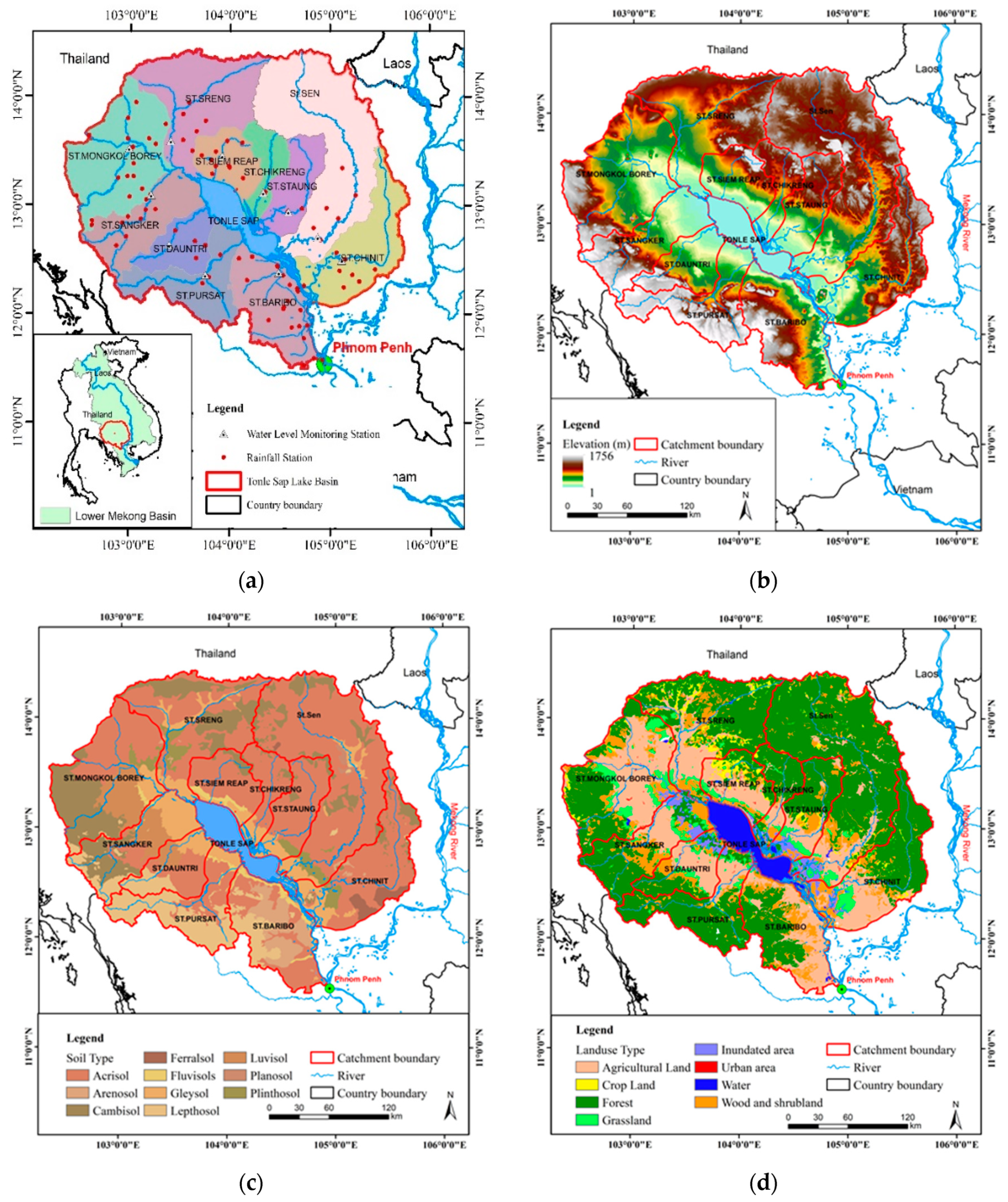
Over the last few decades, water resources in the Tonle Sap basin have been affected by rapid population growth, urbanization, deforestation, agricultural expansion and hydropower demand. In addition, Cambodia is also expected to be seriously affected by the impacts of climate change, due to the high dependency of the economy on the agriculture sector, which sustains the livelihood of approximately 80% of the total population. The effects are likely to include an increased frequency of severe water scarcity and flooding, resulting in crop failures and food shortages [
21].
To properly manage water resources in Cambodia, it is crucial to understand the current and future river flow characteristics of each sub-basin within the Tonle Sap Basin. So far, there has been limited monitoring and hydrological modelling of the potential climate change impacts on flows in tributaries to Tonle Sap Lake, due to limitations in the capacity and resources of national institutions. Most studies have focused on the Mekong mainstream and reverse flows to Tonle Sap Lake [
22,
23,
24,
25]. Kummu et al. [
26] reported that the majority (53.5%) of the water originates from the Mekong mainstream, but the lake’s tributaries also play an important role, contributing 25–30% of the annual flow, while 12.5% is derived from precipitation. The sub-basins clearly play a prominent role in maintaining dry-season lake levels, but they have been poorly monitored and studied. There is thus a need to understand the effect of climate change, and the ongoing developments in the flow contributions from tributary basins to the Tonle Sap.
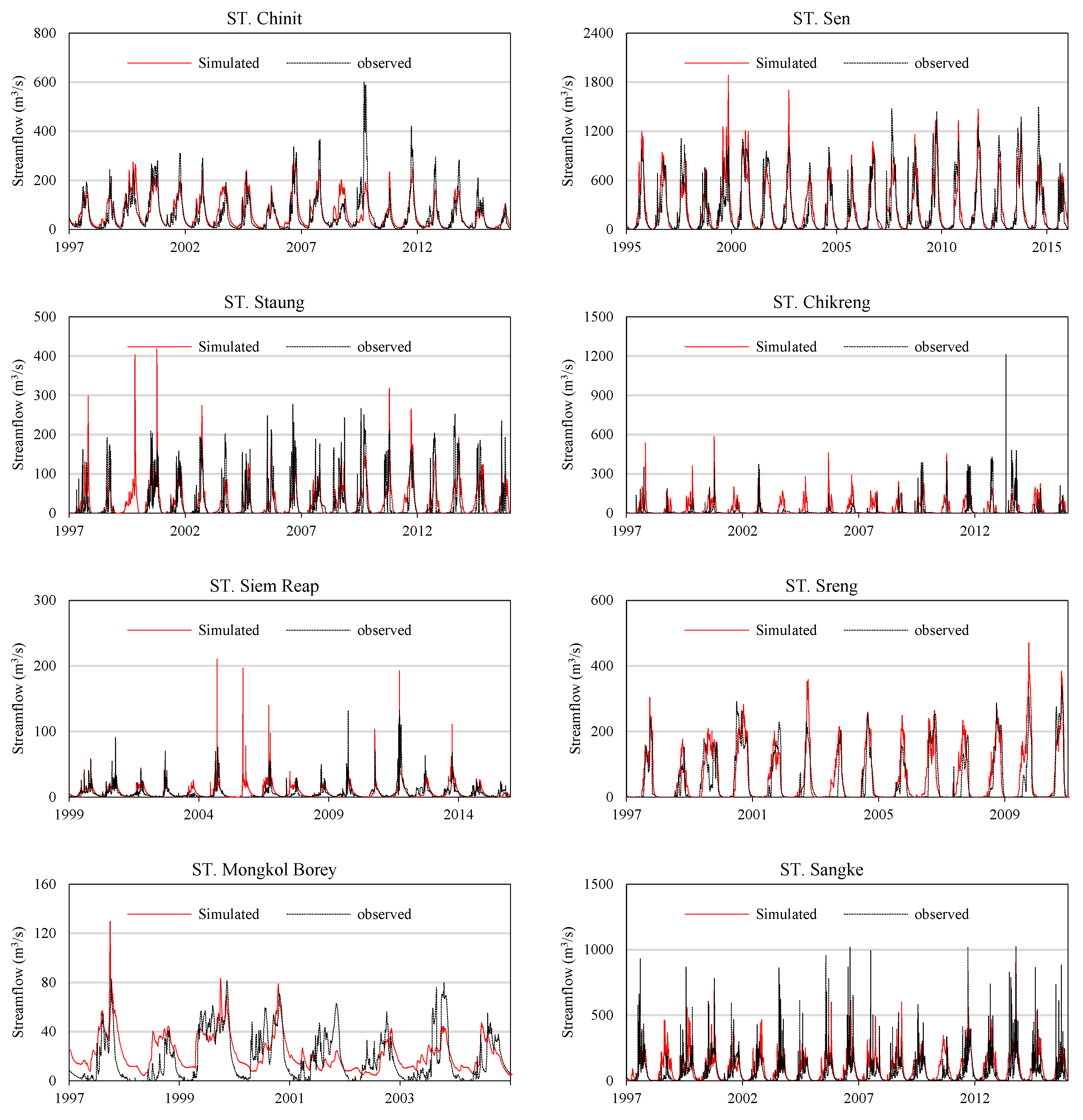
Therefore, the main objectives of this study were to: (1) simulate baseline river flows in all 11 Tonle Sap sub-basins, and (2) to assess the potential impacts of future climate change on river flows within each sub-basin, using a calibrated SWAT model with projected future climate change scenarios.
4. Discussion
The river flow is a result of runoff from the catchment, which is affected by climate, as studied in this paper, but also other factors, such as land use. We expect that land-use changes will result in changes to the runoff regime. Land use has significantly changed in some sub-basins, notably in reduced forest cover. This study used a static 2003 land-use map for the whole simulation period, which would perforce a decrease in the accuracy of simulations, but they serve to isolate the differential effect of climate change on runoff. The relative paucity of the available ground truth data, and the rapid rate of land-use change makes it extremely difficult to forecast landuse with much certainty [
39], but the potential effects of land-use change on runoff should be explored further. In addition, water withdrawals for irrigation and urban water supply were not included in the model, and these are increasing, so that they will likely have a much greater effect in the future. There are, of course, a number of other caveats with the analysis. The effects of hydrological model structure and parameter uncertainties were not considered. However, the effects of model parameter uncertainty have been shown [
40] to be small, relative to the differences between climate scenarios. There are insufficient long-term rain gauges in the headwaters of the Tonle Sap tributaries, thus SWAT-assigned rainfall from the nearest stations, in some cases in Thailand. There is also considerable variability the between climate model scenarios, particularly at the regional scale.
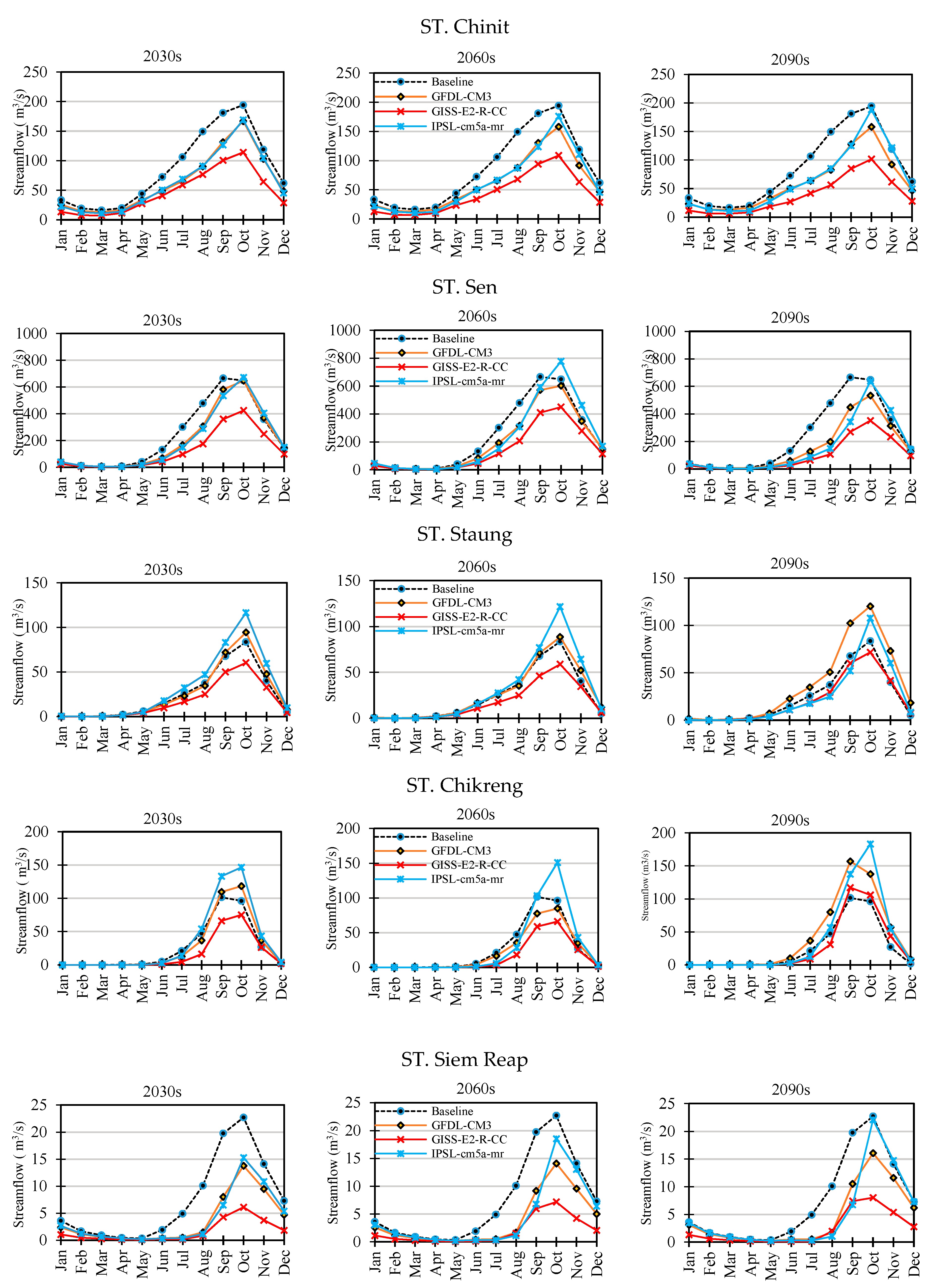
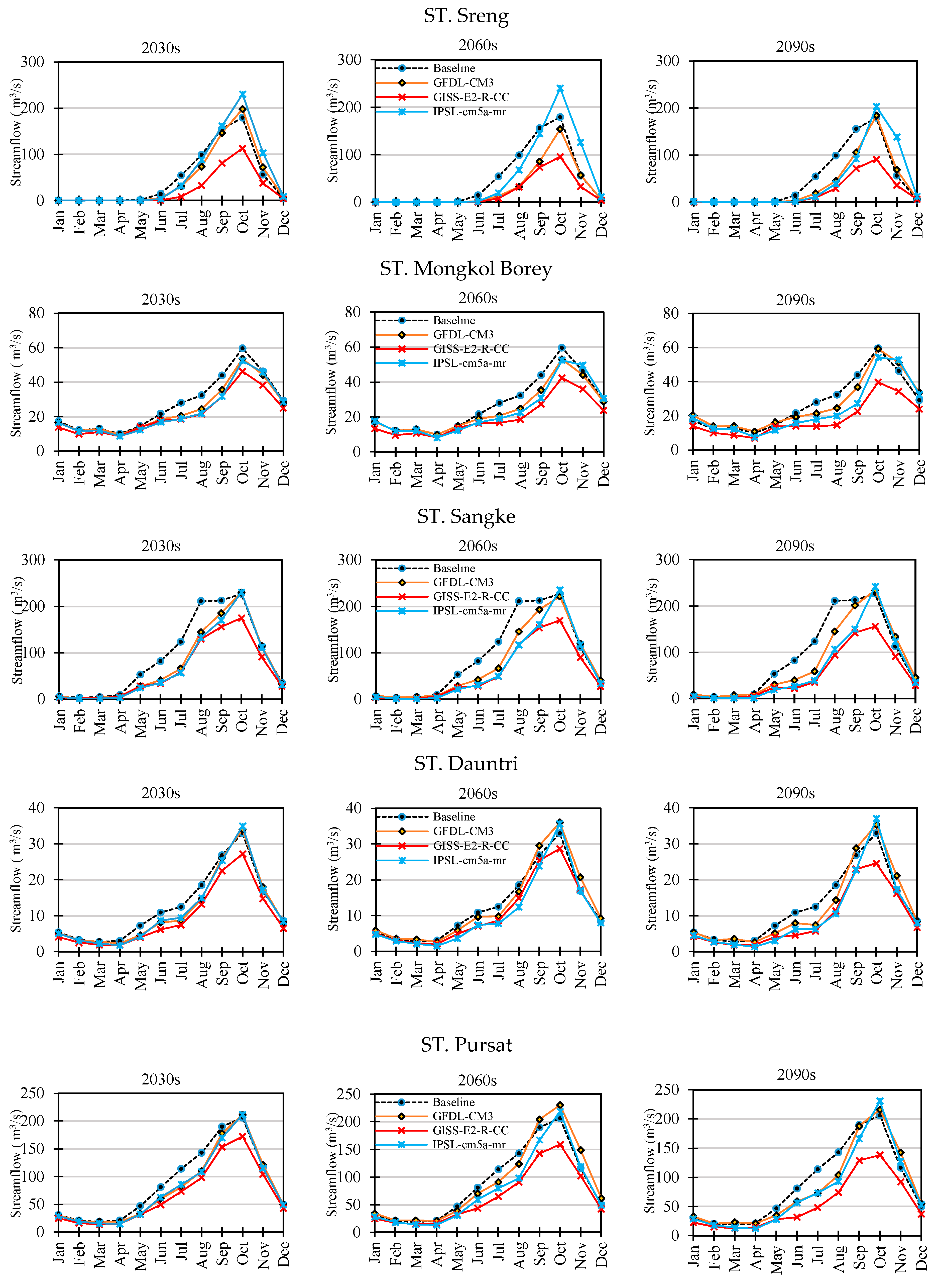
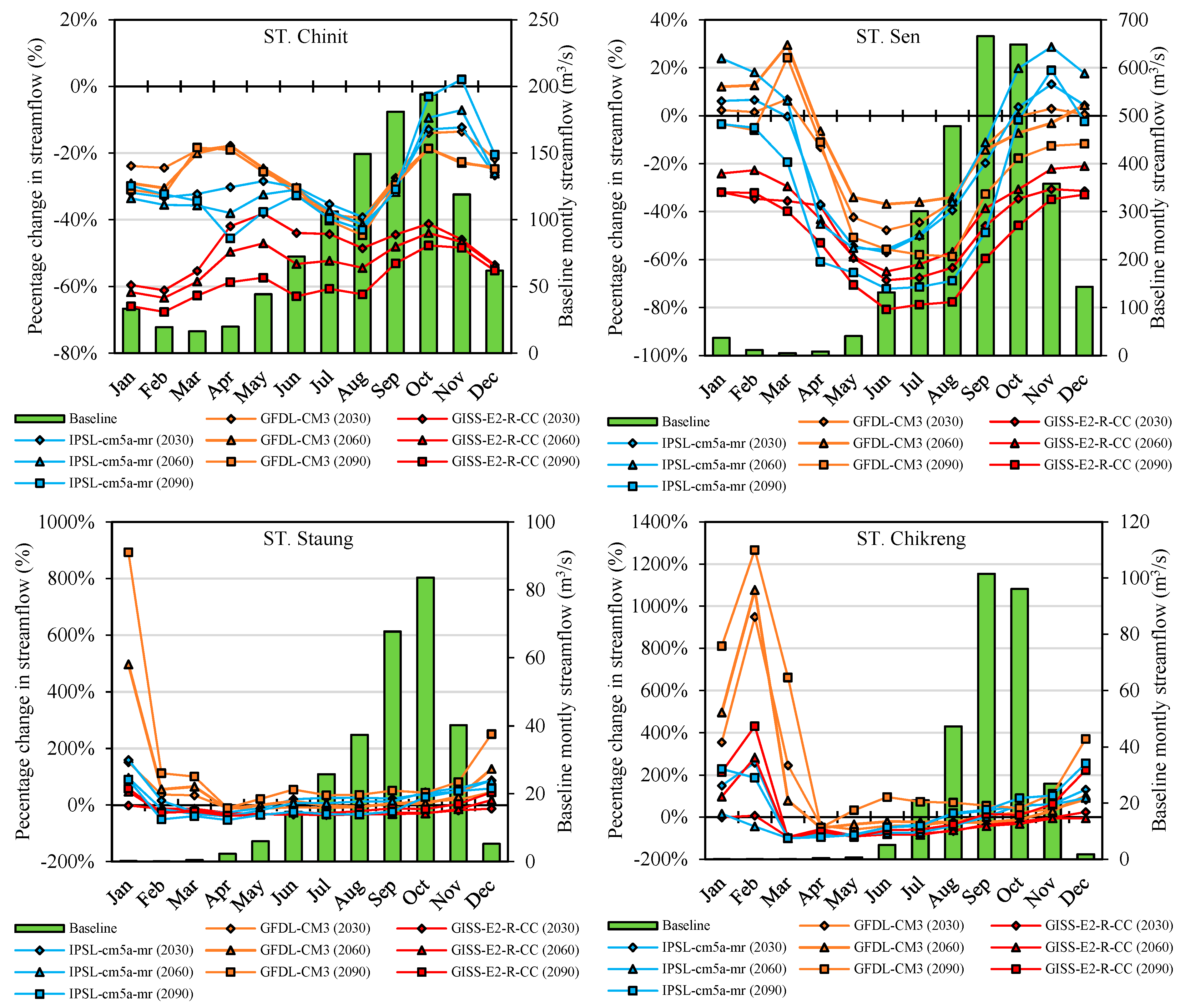
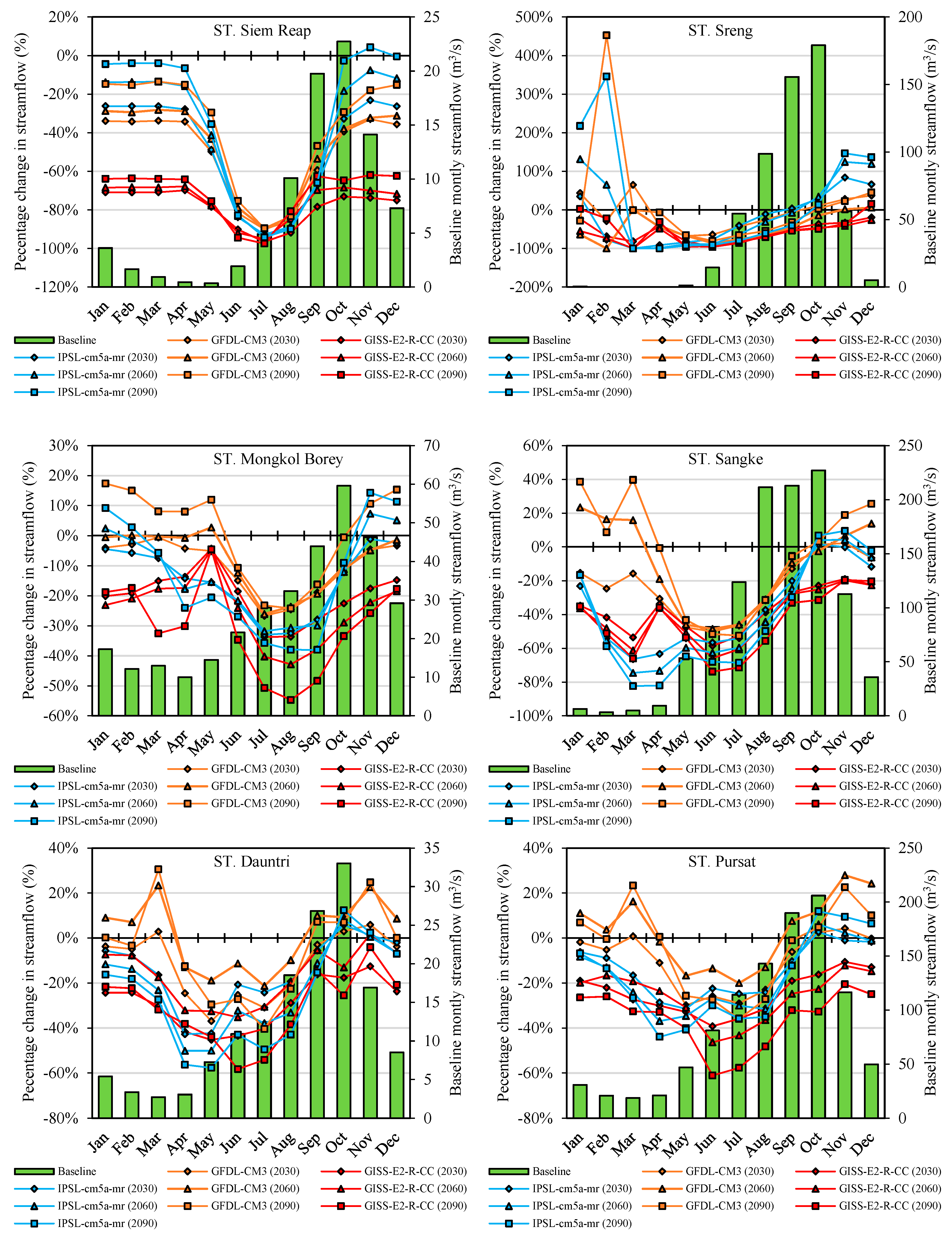
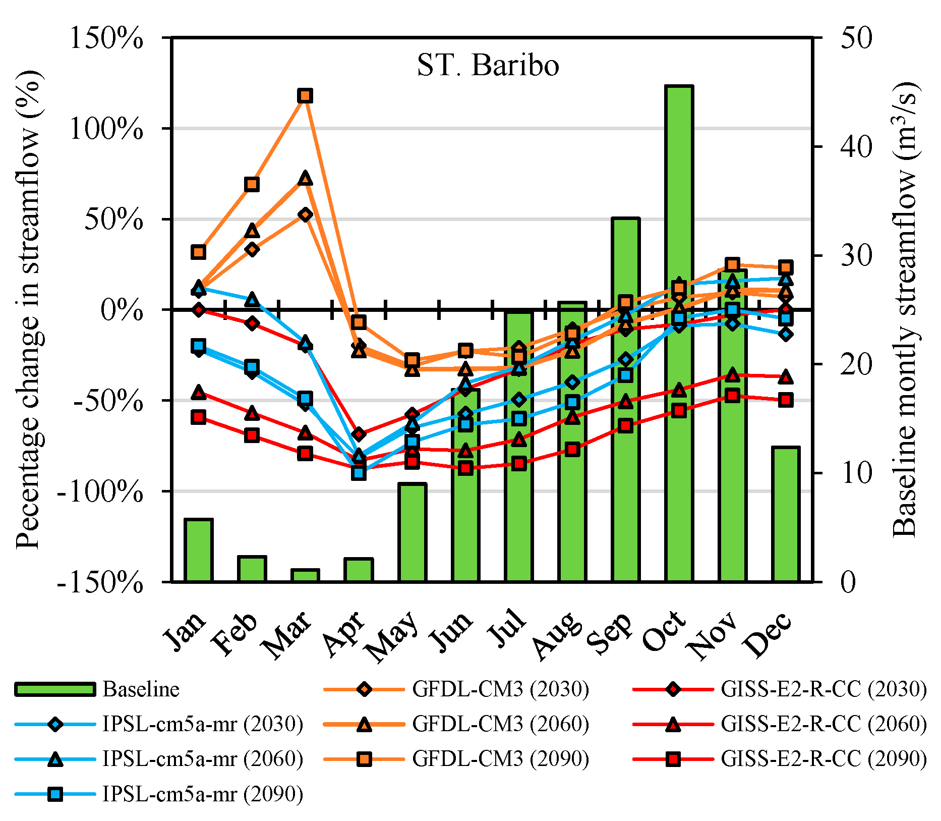
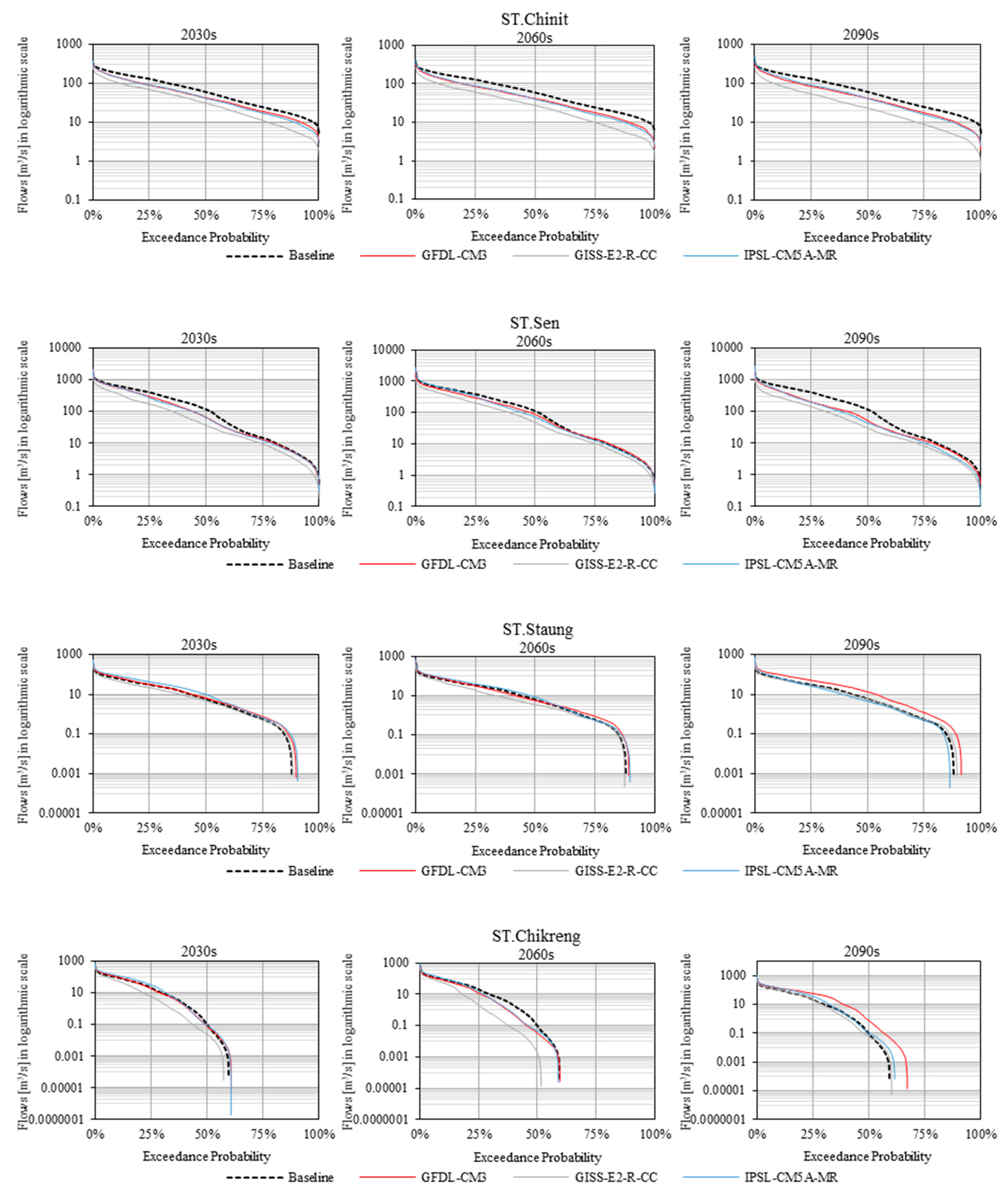
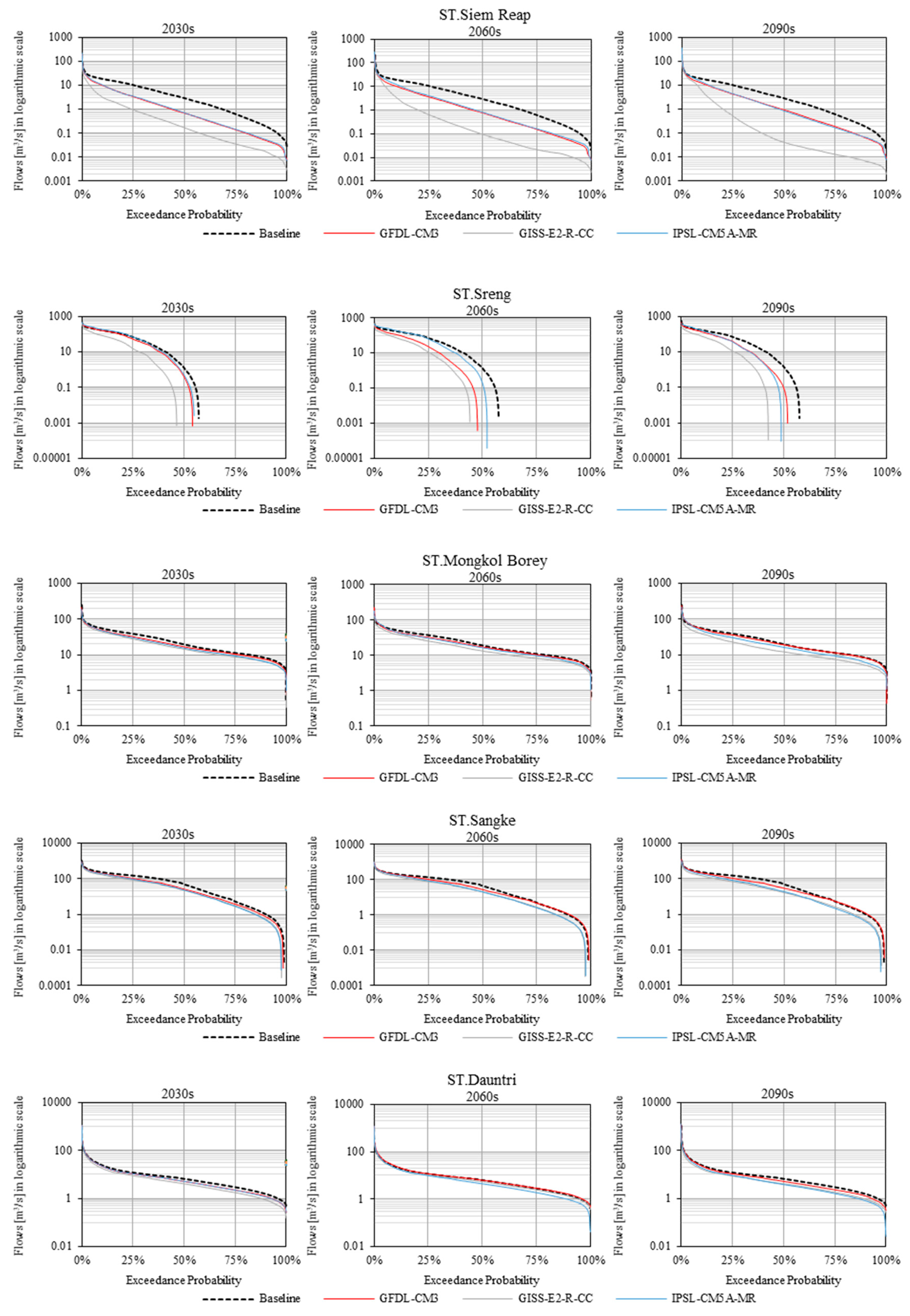
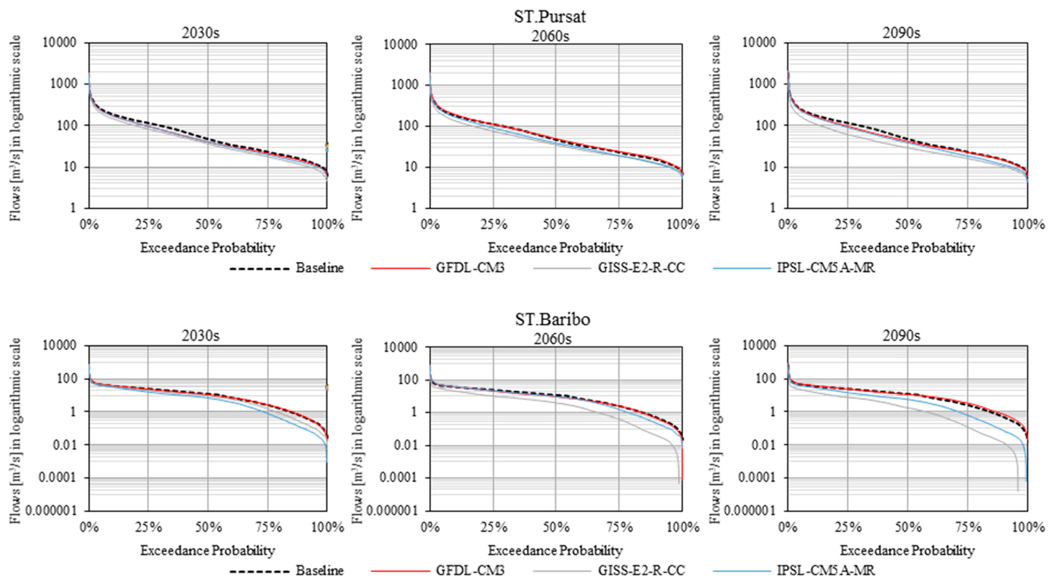
The subsequent assessment of potential impacts of climate change on river flow in these 11 sub-basins was thus conducted by comparing climate change simulations to the baseline scenario. Three General Circulation Models (GFDL-CM3, GISS-E2-R-CC, IPSL-CM5A-MR) for a medium-emissions scenario (RCP 6.0) were employed to project the future climate of the basin. Additionally, three time horizons, consisting of the near-term period (2030s), medium-term period (2060s) and long-term period (2090s) were considered in the investigation the potential impacts of climate change on river flow. The results of the climate change simulations on river flows revealed that it will be more likely that most sub-basins will experience extreme droughts, rather than floods. These results also suggest an increased risk of drought during both the dry and wet season, which would consequently impact future freshwater availability by decreasing both the annual and seasonal flow. The contribution of river flows from all tributaries into the Tonle Sap Lake will be decreasing, due to flow reduction, according to the simulation from the three GCMs and time horizons. These decreases are likely to be attributed to a change in the seasonal distribution of the rainfall, with drier and longer dry seasons, and lower precipitation occurring in the Lower Mekong Basin in the future climate projections, as reported by other studies of climate change in the region [
14,
41]. The analyses performed in this study are perhaps still too uncertain for detailed water management purposes. However, this study gives insights into the sensitivity of this lake basin. In addition to the possible impacts of climate change, some basins such as Pursat, Sen and Sangke are faced with strong development pressures for hydropower and irrigation. Moreover, a decreasing trend of Q
5 and Q
95 was projected by most GCMs for most future time periods, indicating that both the low flows and high flows will be lower than their baseline values. These results were in agreement with studies of future climate-change-induced changes in drought frequency for the Mekong River Basin, such as Hirabayashi et al. [
42], which have projected an increase in drought days by 2100, and MRC (2010), who predicted an increase in drought frequency.
However, uncertainties that are associated with this type of climate change impact study should not be neglected when planning and designing additional water management measures. For instance, many studies have been conducted to assess the uncertainty in river flow projection that are associated with various GCMs under different emission scenarios in the Mekong River Basin [
15,
43]. They noted that the projections of river flow change are highly dependent upon the GCM used, with respect to the direction and magnitude of projected changes in precipitation produced by different GCMs. Indeed, the predictions of future river flow used constant land use and soil property data, unchanged from the baseline period, which is clearly not the case. Moreover, the effects of water infrastructure development projects (e.g., hydropower dams, irrigation schemes) coupled with deforestation, could have greater impacts on the water availability in the near-future (the next 20 to 30 years) than the direct effects of climate change. Therefore, the combined impacts of climate and land use change could significantly reduce river flows within the basin. Further studies are needed in order to assess the potential impacts of climate change that are associated with the future land use changes on river flow in the Tonle Sap Basin. Exploring the implications of water level changes in Tonle Sap Lake is beyond the scope of this study, but we expect that lower water levels would result in reduced a extent of the flooded lake, and likely a reduction in the productivity of the fisheries that depend upon large areas of inundation.
5. Conclusions
Our assessment of climate change effects on hydrological regimes in 11 sub-basins of the Tonle Sap Lake Basin indicate that annual and monthly river flows are likely to decrease in both the wet and dry seasons, for all time horizons (2030s, 2060s and 2090s), and a potential decrease in extreme river flows (Q5 and Q95). These reduced flood peaks and reduced base flows could threaten not only river ecosystems, but also socio-economic development, particularly for the agriculture sector.
This study provides water resources managers and policy makers with a wide range of water flow projections within the Tonle Sap basin, in the context of plausible climate change scenarios, while recognizing the high uncertainty in projections. Future climate change will have an important influence on water resources in the basin. To mitigate anticipated adverse effects will require more efficient methods to manage water resources, such as land cover management, the adoption of best management practices, water storage options and efficient agricultural irrigation systems.

