The Use of Digital Terrain Models to Estimate the Pace of Filling the Pit of a Central European Granite Quarry with Water


Abstract
:1. Introduction
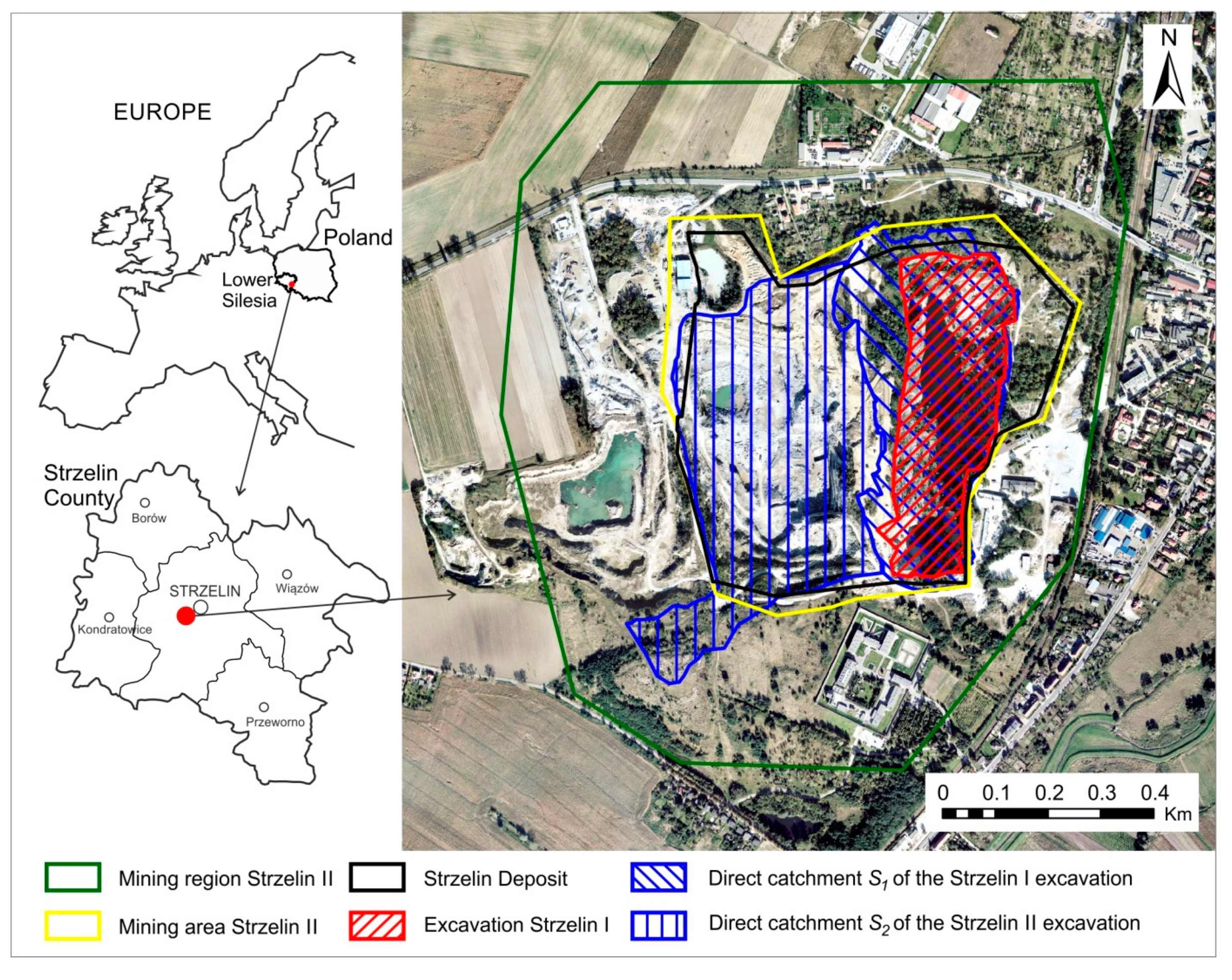
2. Materials and Methods
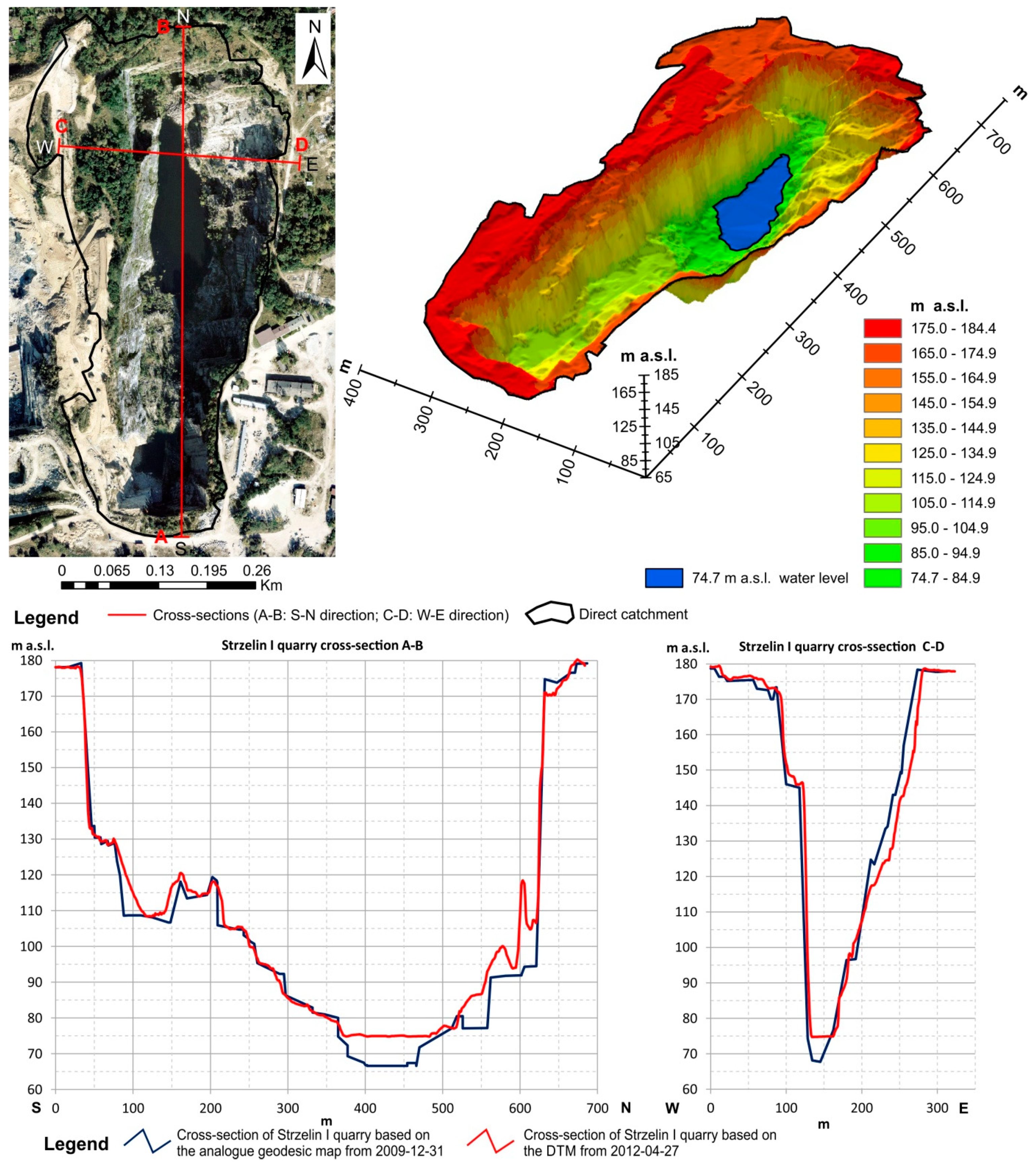
3. Results and Discussion
4. Summary and Conclusions
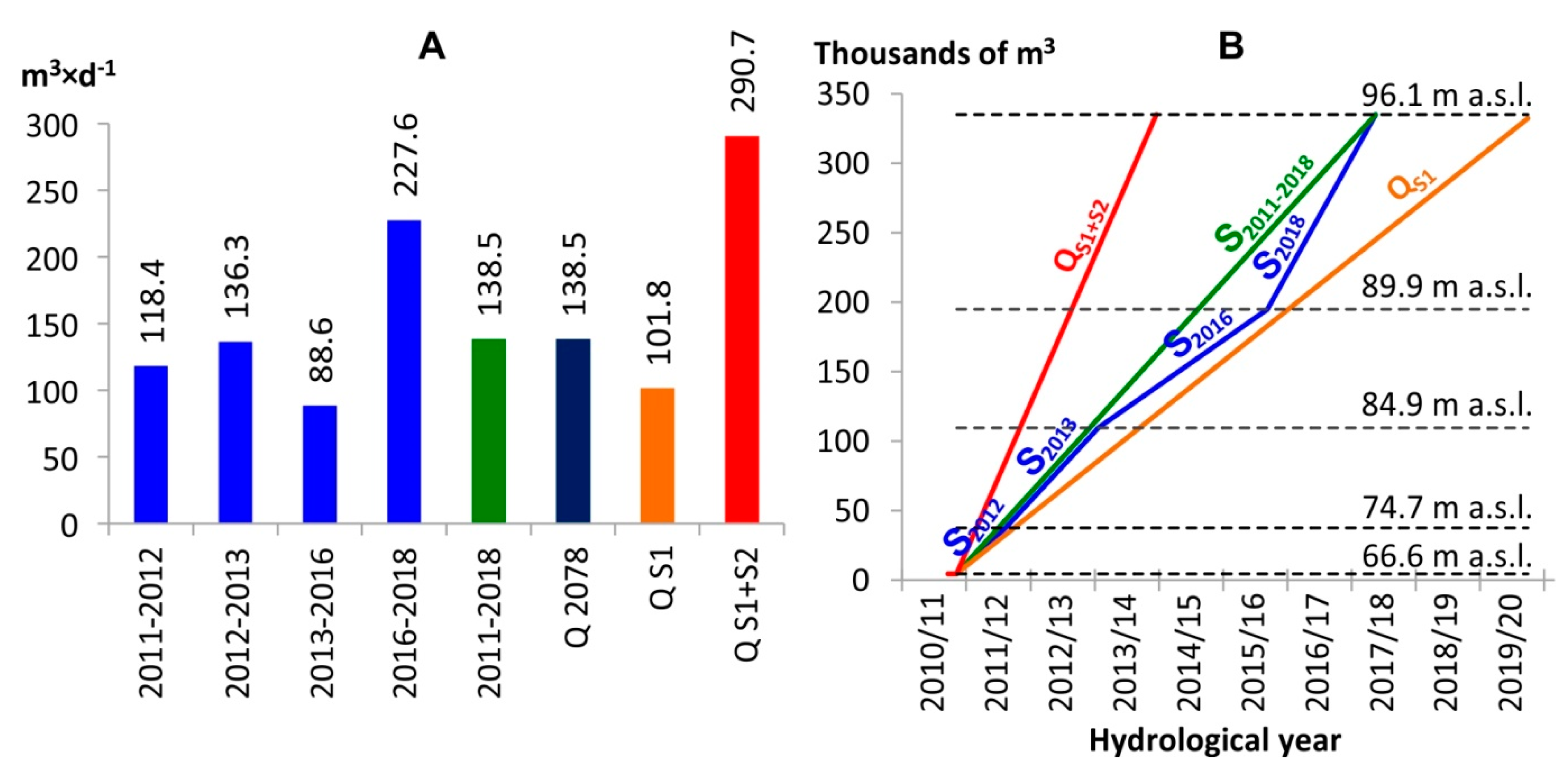
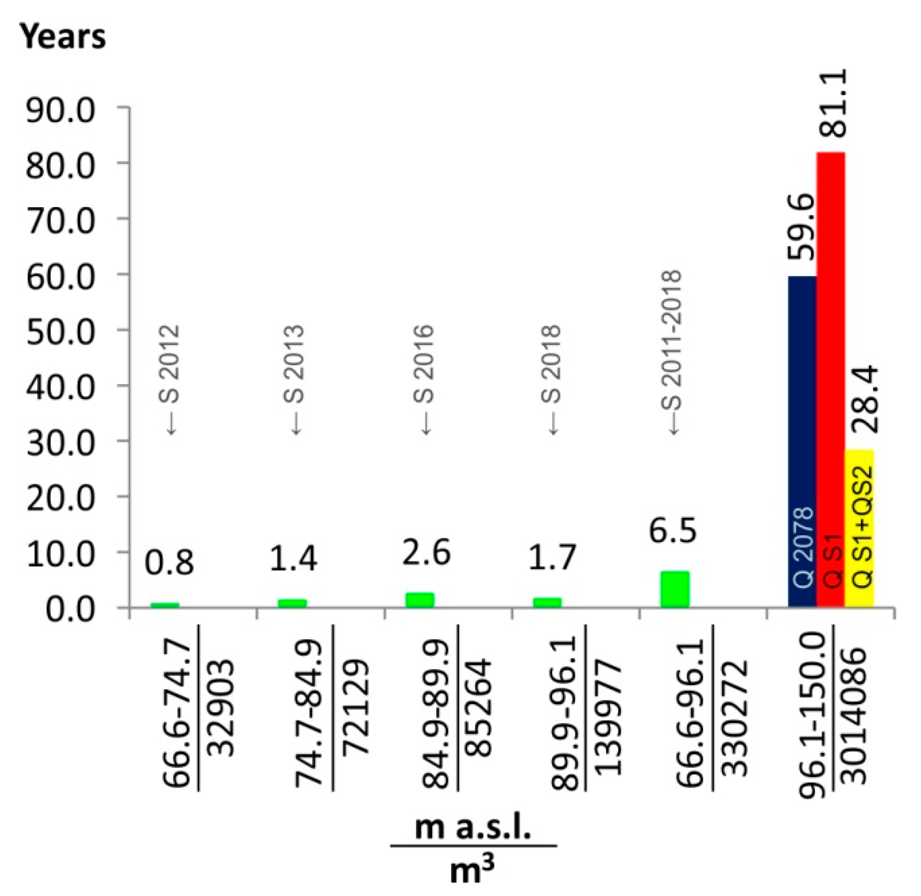
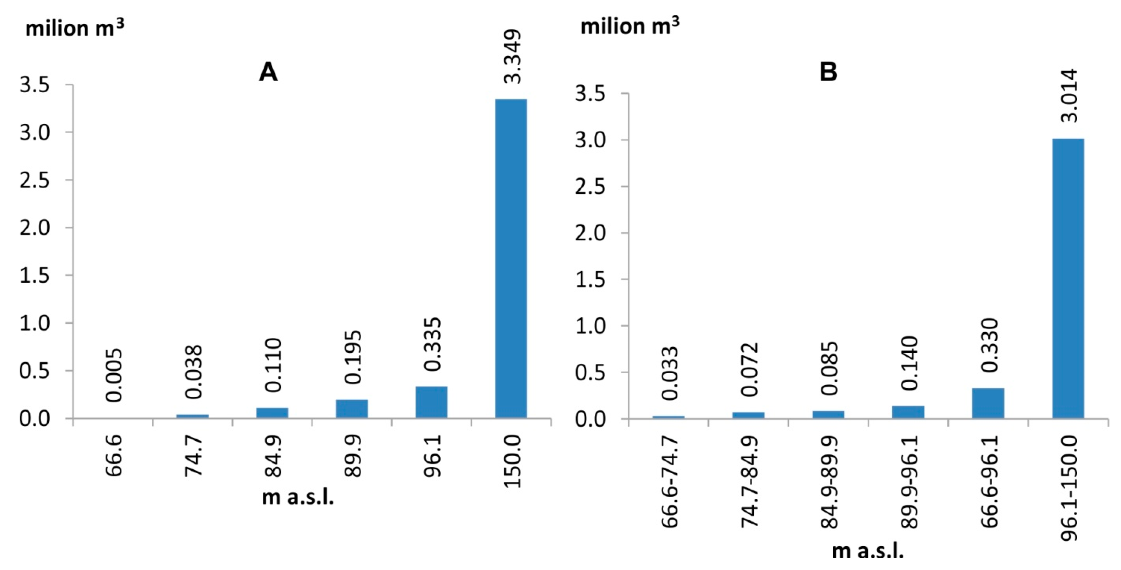
- The use of DTM allowed the authors to determine the morphological parameters of the quarry lake in the Strzelin I pit with satisfactory precision, as of the date of the LiDAR ALS flights: a depth of 8.1 m, a water surface area of 0.48 ha, a water volume of 0.033 million m3 (existing now at a depth of 29.5 m), a water surface area of 2.67 ha, a water volume of 0.335 million m3. The parameters of the prognosed lake that will emerge after discontinuing mining operations are as follows: depth, 83.4 m, water surface area, 7.93 ha, volume of water, 3.335 million m3.
- According to the prognosis, filling the Strzelin I quarry lake to the adopted ordinate of 150.0 m a.s.l. (3.014 million m3) will take 59.6 years based on the average actual retention increase (S2011–2018 = Q2078 = 138.537 m3∙d−1), 81.1 years based on the calculated supply from the direct catchment S1 (QS1 = 101.785 m3∙d−1), and 28.4 years if the total volume of water supplied to Strzelin II is discharged into the pit (QS1+S2=290.662 m3∙d−1).
- If the water direction of reclamation is chosen for the Strzelin I quarry, a high-resolution digital terrain model may be an effective tool for estimating the potential volume of water that may be retained in the bowl of the pit after discontinuing mining operations.
- The use of DTM combined with measurements of the water’s surface level in the bowl of the pit, based on orthophotomaps created at different times, allows one to estimate the actual pace of flooding in the quarry.
Author Contributions
Funding
Conflicts of Interest
References
- Cherlet, M.; Hutchinson, C.; Reynolds, J.; Hill, J.; Sommer, S.; von Maltitz, G. (Eds.) World Atlas of Desertification; Publication Office of the European Union: Luxembourg, 2018. [Google Scholar]
- GUS. Ochrona środowiska 2018 (Environment 2018); Główny Urząd Statystyczny: Warszawa, Poland, 2018; p. 217.
- Axler, R.; Yokom, S.; Tikkanen, C.; McDonald, M.; Runke, H.; Wilcox, D.; Cady, B. Restoration of a Mine Pit Lake from Aquacultural Nutrient Enrichment. Restor. Ecol. 1998, 6, 1–19. [Google Scholar] [CrossRef]
- Hüttl, R.F.; Weber, E. Forest ecosystem development in post-mining landscapes: A case study of the Lusatian lignite district. Naturwissenschaften 2001, 88, 322–329. [Google Scholar] [CrossRef] [PubMed]
- Cao, X. Regulating mine land reclamation in developing countries: The case of China. Land Use Policy 2007, 24, 472–483. [Google Scholar] [CrossRef]
- Paulo, A. Przyrodnicze ograniczenia wyboru kierunku zagospodarowania terenów pogórniczych (Natural constraints of choosing determined directions of post-mining development). Gospod. Surowcami Miner. 2008, 24, 9–40. [Google Scholar]
- Ostręga, A.; Uberman, R. Kierunki rekultywacji i zagospodarowania—sposób wyboru, klasyfikacja i przykłady (Modes of reclamation and redevelopment—Manner of choice, classification and examples). Górnictwo Geoinżynieria 2010, 34, 445–461. [Google Scholar]
- Kaźmierczak, U.; Lorenc, M.W.; Strzałkowski, P. The analysis of the existing terminology related to a post-mining land use: A proposal for new classification. Environ. Earth Sci. 2017, 76, 693. [Google Scholar] [CrossRef]
- Surface Mine Reclamation. In Geology of Illinois; Kolata, D.R.; Nimz, C. (Eds.) Illinois State Geological Survey: Champaign, IL, USA, 2010; pp. 458–465. [Google Scholar]
- Jawecki, B. Kopalnie w krajobrazie powiatu strzelińskiego—Wybrane przykłady zagospodarowania terenów poeksploatacyjnych (Mines in the Landscape of Strzelin County—Selected Examples of Land-Use after Mineral Excavation Areas). Archit. Kraj. 2012, 37, 24–34. [Google Scholar]
- Castendyk, D.N.; Mauk, J.L.; Webster, J.G. A mineral quantification method for wall rocks at open-cast mines, and application to the Martha Au–Ag mine, Waihi, New Zealand. Appl. Geochem. 2005, 20, 135–156. [Google Scholar] [CrossRef]
- Doupé, R.G.; Lymbery, A.J. Environmental Risks Associated with Beneficial End Uses of Mine Lakes in Southwestern Australia. Mine Water Environ. 2005, 24, 134–138. [Google Scholar] [CrossRef]
- Duval, T.P.; Waddington, J.M.; Branfireun, B.A. Towards calcareous wetland creation in flooded abandoned aggregate quarries: A 3-year field mesocosm study. Ecol. Eng. 2010, 36, 586–595. [Google Scholar] [CrossRef]
- Nita, J. Quarries in landscape and geotourism. Geogr. Pol. 2012, 85, 5–12. [Google Scholar] [CrossRef] [Green Version]
- Jawecki, B.; Tokarczyk-Dorociak, K.; Pawęska, K.; Malczewska, B.; Bawiec, A.; Ochman, D. Directions for the reclamation and development of selected quarries in Strzelin county. In Environment Protection in Industrial Areas; Ochman, D., Podoliński, T., Jawecki, B., Eds.; Witelona w Legnicy: Legnica, Poland, 2014. [Google Scholar]
- Soni, A.K.; Mishra, B.; Singh, S. Pit lakes as an end use of mining: A review. J. Min. Environ. 2014, 5, 99–111. [Google Scholar]
- Popović, S.G.; Vukanić, S.; Komatina, D.F.; Alihodzic-Jasarevic, E.; Vatin, N. Models of Landscape Shaping in Exploited Quarries of Urban Area. Procedia Eng. 2015, 117, 609–615. [Google Scholar] [CrossRef] [Green Version]
- Gandah, F.; Atiyat, D. Re-Use of Abandoned Quarries; Case Study of Eco-Tourism and Rangers Academy—Ajloun—Jordan. J. Civ. Environ. Eng. 2016, 6, 238. [Google Scholar] [CrossRef]
- Klapper, H.; Geller, W. Water Quality Management of Mining Lakes—a New Field of Applied Hydrobiology. Acta Hydrochim. Hydrobiol. 2001, 29, 363–374. [Google Scholar] [CrossRef]
- McCullough, C.D. Approaches to remediation of acid mine drainage water in pit lakes. Int. J. Min. Reclam. Environ. 2008, 22, 105–119. [Google Scholar] [CrossRef]
- Tokarczyk-Dorociak, K.; Lorenc, M.W.; Jawecki, B. Zych-Głuszyńska, K. Post-Industrial landscape transformationand its application for geotourism, education and recreation—an example of the Wide Mt. near Strzegom, Lower Silesia/ Poland. Z. Dt. Ges. Geowiss. 2015, 166, 195–203. [Google Scholar]
- Domashenko, Y.; Vasilyev, S. Agroecological, Substantiation for the Use of Treated Wastewater for Irrigation of Agricultural Land. J. Ecol. Eng. 2018, 19, 48–54. [Google Scholar] [CrossRef]
- Jawecki, B.; Dąbek, P.B.; Pawęska, K.; Wei, X. Estimating water retention in post-mining excavations using LiDAR ALS data for the Strzelin Quarry, in Lower Silesia. Mine Water Environ. 2018, 37, 744–753. [Google Scholar] [CrossRef]
- McCullough, C.D.; Lund, M.A. Opportunities for sustainable mining pit lakes in Australia. Mine Water Environ. 2006, 25, 220–226. [Google Scholar] [CrossRef]
- Kumar, R.N.; McCullough, C.D.; Lund, M.A. Water Resources in Australian Mine Pit Lakes. Min. Technol. 2009, 118, 204–211. [Google Scholar] [CrossRef]
- Ravazzani, G.; Giudici, I.; Schmidt, C.; Mancini, M. Evaluating the Potential of Quarry Lakes for Supplemental Irrigation. J. Irrig. Drain. Eng. 2011, 137, 564–571. [Google Scholar] [CrossRef]
- Brugam, R.B.; Chakraverty, S.; Lamkin, J. Sediment chemistry of lakes formed by surface-mining for coal in the midwestern, U.S.A. Hydrobiologia 1988, 164, 221–233. [Google Scholar] [CrossRef]
- Castro, J.M.; Moore, J.N. Pit lakes: Their characteristics and the potential for their remediation. Environ. Geol. 2000, 39, 1254–1260. [Google Scholar] [CrossRef]
- Krüger, B.; Kadler, A.; Fischer, M. The Creation of Post-Mining Landscapes of Lignite Mining in the New Federal States. Surf. Min. Braunkohle Miner. 2002, 54, 161–169. [Google Scholar]
- Ramstedt, M.; Carlsson, E.; Lövgren, L. Aqueous geochemistry in the Udden pit lake, northern Sweden. Appl. Geochem. 2003, 18, 97–108. [Google Scholar] [CrossRef]
- Kleeberg, A.; Grüneberg, B. Phosphorus mobility in sediments of acid mining lakes, Lusatia, Germany. Ecol. Eng. 2005, 24, 89–100. [Google Scholar] [CrossRef]
- Nixdorf, B.; Lessmann, D.; Deneke, R. Mining lakes in a disturbed landscape: Application of the EC Water Framework Directive and future management strategies. Ecol. Eng. 2005, 24, 67–73. [Google Scholar] [CrossRef]
- Castendyk, D.; Eary, T. The nature and global distribution of pit lakes. In Mine Pit Lakes: Characteristics, Predictive Modeling, and Sustainability; Castendyk, D., Eary, T., Park, B., Eds.; Society for Mining Engineering: Englewood, CO, USA, 2009; pp. 1–11. [Google Scholar]
- Dong-Dong, Z.; Yu-shan, S.; Le, L. Study on sustainable landscape design of abandoned quarries: An example: Zhushan ecological park in Xuzhou. Procedia Earth Planet. Sci. 2009, 1, 1107–1113. [Google Scholar] [CrossRef] [Green Version]
- Townsend, F.A.; Helmers, D.P.; Kingdon, C.C.; McNeil, B.E.; de Beurs, K.M.; Eshleman, K.N. Changes in the extent of surface mining and reclamation in the Central Appalachians detected using a 1976–2006 Landsat time series. Remote Sens. Environ. 2009, 113, 62–72. [Google Scholar] [CrossRef]
- Schultze, M.; Pokrandt, K.-H.; Hille, W. Pit lakes of the Central German lignite mining district: Creation, morphometry and water quality aspects. Limnol. (Limnol.—Ecol. Manag. Inland Waters) 2010, 40, 148–155. [Google Scholar] [CrossRef] [Green Version]
- Jawecki, B.; Mirski, J. Wstępna ocena zawartości biogenów w wodach zalanych nieczynnych kamieniołomów położonych na terenach wiejskich (Preliminary evaluation of nutrients concentration in quarry lakes located on the rural areas). Inżynieria Ekol. 2018, 19, 1–13. [Google Scholar] [CrossRef]
- Kasztelewicz, Z. Rekultywacja Terenów Pogórniczych w Polskich Kopalniach Odkrywkowych; (Reclamation of Post-Mining Areas in Polish Open-Cast Mines); Fund. Nauka i Tradycje Górn. AGH: Kraków, Poland, 2010; p. 464. [Google Scholar]
- Czerniawska-Kusza, I.; Brożonowicz, A. Zoobenthos in post-exploitation reservoirs of marls and limestone in Opole Silesia. Pol. J. Nat. Sci. 2014, 29, 307–318. [Google Scholar]
- Svitok, M.; Novikmec, M.; Bitušík, P.; Máša, B.; Oboňa, J.; Očadlík, M.; Michalková, E. Benthic communities of low-order streams affected by acid mine drainages: A case study from Central Europe. Water 2014, 6, 1312–1338. [Google Scholar] [CrossRef]
- Szczepański, J. The significance of groundwater flow modeling study for simulation of opencast mine dewatering, flooding, and the environmental impact. Water 2019, 11, 848. [Google Scholar] [CrossRef]
- Galas, J. Limnological Study on a Lake Formed in a Limestone Quarry (Kraków, Poland). I. Water Chemistry. Polish J. Environ. Stud. 2003, 12, 297–300. [Google Scholar]
- Zawadzki, D. Wykorzystanie zalanych kamieniołomów i wyrobisk pokopalnianych w turystyce specjalistycznej—nurkowanie rekreacyjne (Use of flooded quarries and pit lakes in skilled tourism—SCUBA diving). In Współczesne Problemy Badań Geograficznych; Borówka, R.K., Cedro, A., Kavetskyy, I., Eds.; Contemporary Problems in Geographic Studies; Uniwersytet Szczeciński, Wydział Nauk o Ziemi, Szczecin, wyd: Szczecin, Poland, 2013; pp. 255–267. [Google Scholar]
- Mollema, P.; Antonellini, M.; Hubeek, A.; Van Diepenbeek, P.M.J.A. The effect of artificial recharge on hydrochemistry: A comparison of two fluvial gravel pit lakes with different post-excavation uses in the Netherlands. Water 2016, 8, 409. [Google Scholar] [CrossRef]
- Guziur, J. Charakterystyka małych zbiorników wodnych oraz możliwości ich rybackiego zagospodarowania, część V—nieużytki poeksploatacyjne surowców mineralnych (Characteristics of small water reservoirs and the possibility of their management as fisheries, part V—post-mining wastelands in mineral resources excavation areas). Acta Acad. Agricult. Techn. Olst. Protect. Aqu. Pisc. 1988, 16, 55–65. [Google Scholar]
- Guziur, J. Charakterystyka małych zbiorników wodnych oraz możliwości ich rybackiego zagospodarowania, część VI—zbiorniki pozostałe nieużytki poprzemysłowe (Characteristics of small water reservoirs and the possibility of their management as fisheries, part VI—reservoirs and other post-industrial wastelands). Acta Acad. Agricult. Techn. Olst. Protect. Aqu. Pisc. 1988, 16, 67–77. [Google Scholar]
- Axler, R.; Larsen, C.; Tikkanen, C.; McDonald, M.; Yokom, S.; Aas, P. Water quality issues associated with aquaculture: A case study in mine pit lakes. Water Environ. Res. 1996, 68, 995–1011. [Google Scholar] [CrossRef]
- Kivinen, S. Sustainable post-mining land use: Are closed metal mines abandoned or re-used space? Sustainability 2017, 9, 1705. [Google Scholar] [CrossRef]
- Song, J.; Choi, Y. Analysis of the Potential for Use of Floating Photovoltaic Systems on Mine Pit Lakes: Case Study at the Ssangyong Open-Pit Limestone Mine in Korea. Energies 2016, 9, 102. [Google Scholar] [CrossRef]
- Singleton, V.L.; Jacob, B.; Feeney, M.T.; Little, J.C. Modeling a Proposed Quarry Reservoir for Raw Water Storage in Atlanta, Georgia. J. Environ. Eng. 2013, 139, 70–78. [Google Scholar] [CrossRef]
- Jawecki, B.; Kowalczyk, T.; Feng, Y. The evaluation of the possibility to use water from quarry lakes for irrigation. J. Ecol. Eng. 2019, 20, 188–201. [Google Scholar] [CrossRef]
- Ceppi, A.; Ravazzani, G.; Corbari, C.; Salerno, R.; Meucci, S.; Mancini, M. Real-Time drought forecasting system for irrigation management. Hydrol. Earth Syst. Sci. 2014, 18, 3353–3366. [Google Scholar] [CrossRef]
- Kasperek, R.; Wiatkowski, M.; Rosik-Dulewska, C. Investigations of hydrological regime changes in an area adjacent to a mine of rock raw materials. Annu. Set Environ. Prot. (Rocz. Ochr. Środowiska) 2015, 17, 256–274. [Google Scholar]
- Grünewald, U. Water resources management in river catchments influenced by lignite mining. Ecol. Eng. 2001, 17, 143–152. [Google Scholar] [CrossRef]
- Hüttl, R.F.; Gerwin, W. Landscape and ecosystem development after disturbance by mining. Ecol. Eng. 2005, 24, 1–3. [Google Scholar] [CrossRef]
- Clews, E.; Low, E.; Belle, C.C.; Todd, P.A.; Eikaas, H.S.; Ng, P.K.L. A pilot macroinvertebrate index of the water quality of Singapore’s reservoirs. Ecol. Indic. 2014, 38, 90–103. [Google Scholar] [CrossRef]
- Kumar, N.R.; McCullough, C.D.; Lund, M.A.; Larranaga, S.A. Assessment of factors limiting algal growth in acidic pit lakes—A case study from Western Australia, Australia. Environ. Sci. Pollut. Res. 2016, 23, 5915–5924. [Google Scholar] [CrossRef]
- Kołodziejczyk, U. Hydrological, geological and geochemical conditions determining reclamation of post—mine land in the region of Łęknica. Gospod. Surowcami Miner. 2009, 25, 190–201. [Google Scholar]
- Wachowiak, G.; Wachowiak, A. Zalewanie wyrobiska końcowego Odkrywki “Pątnów” Kopalni Węgla Brunatnego “Konin” w świetle określenia składowych i obliczeń bilansu wodnego zbiornika (Flooding of the abandoned Open Pit “Pątnów” of the “Konin” lignite opencast mine in the light of the water balance calculation and determination of its elements). Górnictwo Odkryw. 2010, 51, 77–85. [Google Scholar]
- Polak, K.; Różkowski, K.; Pawlecka, K.; Kaznowska-Opala, K.; Chudzik, W. Prognoza zatapiania wyrobiska poeksploatacyjnego Świerki (Forecast of flooding of the post-mining excavation Swierki). Przegląd Górniczy 2014, 70, 31–36. [Google Scholar]
- Hayley, K.; Valenza, A.; White, E.; Hutchison, B.; Schumacher, J. Application of the iterative ensemble smoother method and cloud computing: A groundwater modeling case study. Water 2019, 11, 1649. [Google Scholar] [CrossRef]
- Filippova, K.A.; Deryagin, V.V. Chemical Hydrology of Mine Pit Lakes of the Bakala Geotechnic System (Southern Urals). Water Resour. 2005, 32, 427–433. [Google Scholar] [CrossRef]
- Hinwood, A.L.; Heyworth, J.; Tanner, H.; McCullough, C. Recreational Use of Acidic Pit Lakes—Human Health Considerations for Post Closure Planning. J. Water Resour. Prot. 2012, 4, 1061–1070. [Google Scholar] [CrossRef]
- Doyle, G.A.; Runnells, D.D. Physical limnology of existing mine pit lakes. Min. Eng. 1997, 49, 76–80. [Google Scholar]
- Denimal, S.; Bertrand, C.; Mudry, J.; Paquette, Y.; Hochart, M.; Steinmann, M. Evolution of the aqueous geochemistry of mine pit lakes–Blanzy–Montceau-les-Mines coal basin (Massif Central, France): Origin of sulfate contents; effects of stratification on water quality. Appl. Geochem. 2005, 20, 825–839. [Google Scholar] [CrossRef]
- Vandenberg, J.; McCullough, C.; Castendyk, D. Key issues in Mine Closure Planning Related to Pit Lakes. In Proceedings of the 10th International Conference on Acid Rain Drainage & IMWA Annual Conference, Santiago, Chile, 21–24 April 2015. [Google Scholar]
- Molenda, T. Górnicze środowiska akwatyczne—obiekty obserwacji procesów hydrologiczno-biologicznych (Mining aquatic environments as the objects of hydrolog1cal and biological processes). Pr. Nauk. Inst. Górnictwa Politech. Wrocławskiej 2006, 17, 239–250. [Google Scholar]
- Chudzik, W. The process of mined land reclamation in natural aggregate quarries exemplified by the sand and gravel quarry Dębina Łętowska. AGH J. Min. Geoengin. 2012, 36, 89–96. [Google Scholar]
- Kołodziejczyk, U.; Węclewski, S. Wykorzystanie wód powierzchniowych do rekultywacji wyrobisk pokopalnianych na przykładzie kopalni Berzdorf (The use of surface water for the remediation of mining excavations on the example of mine Berzdorf). Zesz. Nauk. Uniw. Zielonogór. 2004, 131, 189–195. [Google Scholar]
- Kasztelewicz, Z.; Kaczorowski, J. Rekultywacja i rewitalizacja kopalń węgla brunatnego na przykładzie kopalni “Bełchatów” (Lignite mines revitalization based on the example of Bełchatów Lignite Mine). Górnictwo Geoinżynieria 2009, 33, 187–212. [Google Scholar]
- Kasztelewicz, Z.; Sypniowski, S. Rekultywacja w polskim górnictwie odkrywkowym węgla brunatnego (Reclamation in Polish opencast brown coal mining). Górnictwo Geoinżynieria 2010, 34, 289–304. [Google Scholar]
- Walczykiewicz, P.; Szostak, M.; Krzaklewski, W.; Pająk, M.; Pierzchalski, M.; Szwed, P.; Hawryło, P.; Ratajczak, M. Landscape monitoring of post-industrial areas using LiDAR and GIS technology. Geod. Cartogr. 2015, 64, 125–137. [Google Scholar] [Green Version]
- Xiang, J.; Li, S.; Xiao, K.; Chen, J.; Sofia, G.; Tarolli, P. Quantitative Analysis of Anthropogenic Morphologies Based on Multi-Temporal High-Resolution Topography. Remote Sens. 2019, 11, 1493. [Google Scholar] [CrossRef]
- Labant, S.; Staňková, S.; Weiss, R. Geodetic determining of stockpile volume of mineral excavated in open-cast mine. Geosci. Eng. 2013, 1, 30–40. [Google Scholar] [CrossRef]
- Sayab, M.; Aerden, D.; Paananen, M.; Saarela, P. Virtual Structural Analysis of Jokisivu Open Pit Using ‘Structure-from-Motion’ Unmanned Aerial Vehicles (UAV) Photogrammetry: Implications for Structurally-Controlled Gold Deposits in Southwest Finland. Remote Sens. 2018, 10, 1296. [Google Scholar] [CrossRef]
- Witt, E.C., III. Use of LiDAR point cloud data to support estimation of residual trace metals stored in mine chat piles in the Old Lead Belt of southeastern, Missouri. AIMS Environ. Sci. 2016, 3, 509–524. [Google Scholar] [CrossRef]
- Wajs, J. Research on surveying technology applied for DTM modelling and volume computation in open-cast mines. Min. Sci. 2015, 22, 75–83. [Google Scholar]
- Tong, X.; Liu, X.; Chen, P.; Liu, S.; Luan, K.; Li, L.; Liu, S.; Liu, X.; Xie, H.; Jin, Y.; et al. Integration of UAV-Based Photogrammetry and Terrestrial Laser Scanning for the Three-Dimensional Mapping and Monitoring of Open-Pit Mine Areas. Remote Sens. 2015, 7, 6635–6662. [Google Scholar] [CrossRef] [Green Version]
- Esposito, G.; Matano, F.; Sacchi, M. Detection and Geometrical Characterization of a Buried Landfill Site by Integrating Land Use Historical Analysis, Digital Photogrammetry and Airborne Lidar Data. Geosciences 2018, 8, 348. [Google Scholar] [CrossRef]
- Gong, C.; Lei, S.; Bian, Z.; Liu, Y.; Zhang, Z.; Cheng, W. Analysis of the development of an erosion gully in an open-cast coal mine dump during a winter freeze-thaw cycle by using Low-Cost UAVs. Remote Sens. 2019, 11, 1356. [Google Scholar] [CrossRef]
- Xu, Z.; Xu, E.; Wu, L.; Liu, S.; Mao, Y. Registration of Terrestrial Laser Scanning Surveys Using Terrain-Invariant Regions for Measuring Exploitative Volumes over Open-Pit Mines. Remote Sens. 2019, 11, 606. [Google Scholar] [CrossRef]
- Walczak, Z.; Sojka, M.; Wróżyński, R.; Laks, I. Estimation of Polder Retention Capacity Based on ASTER, SRTM and LIDAR DEMs: The Case of Majdany Polder (West Poland). Water 2016, 8, 230. [Google Scholar] [CrossRef]
- Szewrański, S.; Chruściński, J.; Kazak, J.; Świąder, M.; Tokarczyk-Dorociak, K.; Żmuda, R. Pluvial flood risk assessment tool (PFRA) for rainwater management and adaptation to climate change in newly urbanised areas. Water 2018, 10, 386. [Google Scholar] [CrossRef]
- Szewrański, S.; Chruściński, J.; van Hoof, J.; Kazak, J.; Świąder, M.; Tokarczyk-Dorociak, K.; Żmuda, R. A location intelligence system for the assessment of pluvial flooding risk and the identification of storm water pollutant sources from roads in suburbanised areas. Water 2018, 10, 746. [Google Scholar] [CrossRef]
- Kazak, J.; Chruściński, J.; Szewrański, S. The Development of a Novel Decision Support System for the Location of Green Infrastructure for Stormwater Management. Sustainability 2018, 10, 4388. [Google Scholar] [CrossRef]
- Laks, I.; Kałuża, T.; Sojka, M.; Walczak, Z.; Wróżyński, R. Problems with Modelling Water Distribution in Open Channels with Hydraulic Engineering Structures. Annu. Set Environ. Prot. (Rocz. Ochr. Środowiska) 2013, 15, 245–257. [Google Scholar]
- Szewrański, S.; Kazak, J.; Szkaradkiewicz, M.; Sasik, J. Flood Risk Factors in Suburban Area in the Context of Climate Change Adaptation Policies—Case Study of Wroclaw, Poland. J. Ecol. Eng. 2015, 16, 13–18. [Google Scholar] [CrossRef]
- Laks, I.; Sojka, M.; Walczak, Z.; Wróżyński, R. Possibilities of Using Low Quality Digital Elevation Models of Floodplains in Hydraulic Numerical Models. Water 2017, 9, 283. [Google Scholar] [CrossRef]
- Wachowiak, G.; Wachowiak, A. Zbiornik w wyrobisku końcowym Odkrywki “Pątnów” Kopalni Węgla Brunatnego “Konin” i jego bilans wodny za okres 2003–2004 (Reservoir at the closing excavation of the open-cast “Pątnów” of the lignite opencast mine "Konin" and its water balance in 2003–2004). Bad. Fizjogr. Nad Polską Zach. Ser. A-Geogr. Fiz. 2005, 56, 157–176. [Google Scholar]
- Kołodziejczyk, U.; Asani, A. Hydrologia pojezierza antropogenicznego w rejonie Łęknicy (południowo-zachodnia Polska), (Hydrology of the antropogenic reservoirs in Łęknica (south-western Poland). Acta Sci. Pol. Form. Circumiectus 2012, 11, 27–44. [Google Scholar]
- Wachowiak, G. Bilans wodny zbiornika w zalewanym wyrobisku końcowym likwidowanej odkrywki “Lubstów” PAK Kopalnia Węgla Brunatnego Konin, S.A. (Water balance of a reservoir in the flooded, abandoned, open-cast “Lubstów” PAK Lignite Opencast Mine Konin, S.A.). Górnictwo Odkryw. 2015, 56, 68–79. [Google Scholar]
- Ciupa, T.; Suligowski, R.; Wiatkowski, M. Wpływ zrzutów wód z planowanej kopalni wapieni na Przedgórzu Iłżeckim na przepływ w ciekach od V do II rzędu (The Influence of Water Discharge from Planned Limestone Mine in Iłża Foothills on Runoff of 5th to 2nd Order Streams). Annu. Set Environ. Prot. (Rocz. Ochr. Środowiska) 2016, 18, 325–335. [Google Scholar]
- Rapantova, N.; Grmela, A.; Vojtek, D.; Halir, J.; Bedrich, M. Ground water flow modeling applications in mining hydrogeology. Mine Water Environ. 2007, 26, 264–270. [Google Scholar] [CrossRef]
- Singh, V.P.; Frevert, D.K. Watershed Models; Taylor & Francis Group: Boca Raton, FL, USA, 2006. [Google Scholar]
- US EPA. BASINS 4.5 (Better Assessment Science Integrating point & Non-point Sources) Modeling Framework. National Exposure Research Laboratory, RTP, North Carolina (2019). Available online: www.epa.gov/sites/production/files/2019-03/documents/basins4.5coremanual.2019.03.pdf (accessed on 19 August 2019).
- Johnson, B.E.; Julien, P.Y. The two-dimensional upland erosion model CASC2D-SED. The Hydrology-Geomorphology Interface: Rainfall, Floods, Sedimentation, Land use. IAHS Proc. Rep. 2000, 261, 107–125. [Google Scholar]
- Singh, V.P.; Frevert, D.K. Mathematical Models of Small Watershed Hydrology and Applications; Water Resources Publication: Highlands Ranch, CO, USA, 2002. [Google Scholar]
- Banasik, K.; Wałęga, A.; Węglarczyk, S.; Więzik, B. Aktualizacja metodyki obliczania przepływów i opadów maksymalnych o określonym prawdopodobieństwie przewyższenia dla zlewni kontrolowanych i niekontrolowanych oraz identyfikacji modeli transformacji opadu w odpływ (Updated methodology of calculating maximum flows and rainfall of specified excession probability for controlled and uncontrolled catchments and the identification of models of rainfall-runoff transformation). Krajowy Zarząd Gospodarki Wodnej, Stowarzyszenie Hydrologów Polskich, Warszawa. 2017. Available online: https://www.kzgw.gov.pl/files/zam-pub/20170402-przeglad-i-aktualizacja-map/zal-2-do-OPZ-ujednolicony-1.pdf (accessed on 19 August 2019).
- Bilans Zasobów Złóż Kopalin w Polsce wg Stanu na 31 XII 2017 r; (Balance of the Mineral Deposit Resources in Poland as of the 31. 12. 2017); Państwowy Instytut Geologiczny: Warszawa, Poland, 2018.
- Jawecki, B. Dynamika przemian krajobrazu terenów eksploatacji surowców naturalnych na przykładzie kamieniołomów Strzelina. (Dynamics of the transformation of natural resources exploitation areas based on the example of Strzelin quarries.). In Human and the Environment—Coexistence or Competition (Człowiek a środowisko—koegzystencja czy konkurencja); Raszka, B., Hełdak, M., Eds.; Bogucki Wydawnictwo Naukowe: Poznań, Poland, 2019; pp. 93–106. [Google Scholar]
- MIDAS—System for the protection and management of mineral sources. Available online: https://btscbdg.pgi.gov.pl/midas-web/index.html (accessed on 30 October 2019).
- Lorenc, M.W. Petrogeneza ksenolitów w granitoidach strzelińskich. (Petrogenesis of xenoliths in the Strzelin granitoids). Geol. Sud. 1984, 18, 133–166. [Google Scholar]
- Lorenc, M.W. Enklawy homeogeniczne (autolity) jakowskaźnik magmowego pochodzenia granitoidów strzelińskich. (Endogenous enclosures (autoliths) as evidence of magmatic origin of the Strzelin granitoids). Geol. Sud. 1984, 19, 75–100. [Google Scholar]
- Lorenc, M.W. Rola magm zasadowych w ewolucji intruzji granitoidowych (studium porównawcze wybranych masywów hercyńskich) (Role of basic magmas in the granitoid evolution (a comparative study of some Hercynian Massifs). Geol. Sudet. 1994, 28, 3–133. [Google Scholar]
- Oberc-Dziedzic, T.; Kryza, R.; Pin, C.; Madej, S. Variscan granitoid plutonism in the Strzelin Massif (SW Poland): Petrology and age of the composite Strzelin granite intrusion. Geol. Q. 2013, 57, 269–288. [Google Scholar] [CrossRef]
- Oberc-Dziedzic, T.; Kryza, R.; Pin, C.; Madej, S. Sequential granite emplacement: A structural study of the late Variscan Strzelin intrusion, SW Poland. Int. J. Earth Sci. (Geol. Rundsch.) 2013, 102, 1289–1304. [Google Scholar] [CrossRef]
- Depciuch, T.; Lis, J. Wiek bezwzględny (K-Ar) granitoidów strzelińskich (Absolute age (K-Ar) of Strzelin’s granitoids). Kwart. Geol. 1972, 16, 95–102. [Google Scholar]
- Oberc-Dziedzic, T.; Pin, C.; Duthou, J.L.; Couturie, J.P. Age and origin of the Strzelin granitoids (Fore-Sudetic Block, Poland): 87Rb/86Sr data. Neues Jahrb. für Mineral. Abh. 1996, 171, 187–198. [Google Scholar]
- Turniak, K.; Tichomirowa, M.; Bombach, K. Pb-Evaporation Zircon Ages from the Strzelin Massif (SW Poland). Mineral. Soc. Poland. 2006, 29, 212–215. [Google Scholar]
- Oberc-Dziedzic, T.; Kryza, R.; Klimas, K.; Fanning, M.C.; Madej, S. Gneiss protolith ages and tectonic boundaries in the NE part of the Bohemian Massif (Fore-Sudetic Block, SW Poland). Geol. Q. 2005, 49, 363–378. [Google Scholar]
- Jawecki, B. Rola Kamieniołomów w Kształtowaniu Krajobrazu na Przykładzie Ziemi Strzelińskiej (the Role of Quarries in Shaping Landscape Based on the Example of the Strzelin Region); Uniwersytet Przyrodniczy we Wrocławiu: Wrocław, Poland, 2017; p. 269. [Google Scholar]
- Balawajder, J. Dokumentacja Geologiczna Złoża Granitu i Gnejsu Strzelin, w kat C1+B (Geological Documentation. Granite and Gneiss Deposits Strzelin, category C1+B); Typescript: Wrocław, Poland, 1988. [Google Scholar]
- Kominowski, K. Kopalnia Granitu “Strzelin”—Mapa Numeryczna Wyrobisk Górniczych, Aktualna na 2009-12-31 (“Strzelin” Granite Quarry—Digital Map of Mining Pits as of the 2009-12-31); Usługi Geologiczne i Geodezyjne “GEOMETR”: Szczawno Zdrój, Poland, 2009. [Google Scholar]
- IMGW Meteorological Station in Strzelin No. ID 95341. Average and Monthly Sum of Precipitation. Available online: https://meteomodel.pl/dane/srednie-miesieczne/?imgwid=250170090&par=prcp&max_empty=2 (accessed on 20 July 2019).
- Das, M.M.; Saikia, M.D. Watershed Menagement; PHI Learning Pvt. Ltd.: Delhi, India, 2012; p. 203. [Google Scholar]
- Drabiński, A.; Radczuk, L.; Nyc, K.; Mokwa, M.; Olearczyk, B.; Markowska, J.; Bac-Bronowicz, J.; Chmielewska, I.; Jawecki, B.; Gromada, O.; et al. 2006: Program małej retencji wodnej w województwie dolnośląskim (Programme of small-scale water retention in the Lower Silesian Voivodeship). Available online: http://bip.umwd.dolnyslask.pl/dokument.php?iddok=32376&str=11 (accessed on 13 August 2019).
- Stachowski, P.; Kraczkowska, K.; Liberacki, D.; Oliskiewicz-Krzywicka, A. Water Reservoirs as an Element of Shaping Water Resources of Post-Mining Areas. J. Ecol. Eng. 2018, 19, 217–225. [Google Scholar] [CrossRef]
- State Water Holding—Polish Waters (polish name: Państwowe Gospodarstwo Wodne—Wody Polskie). Komputerowa Mapa Podziału Hydrograficznego Polski (The Watershed Computer Map of Poland). 2019. Available online: https://dane.gov.pl/dataset/869,komputerowa-mapa-podziau-hydrograficznego-polski (accessed on 30 October 2019).
- Uchwała nr XLVIII/1137/17 Rady Miejskiej Wrocławia z dnia 23 listopada 2017r. w sprawie „Programu Ochrony Środowiska dla miasta Wrocławia na lata 2016-2020 z perspektywą do roku 2025”. (Resolution No. XLVIII/1137/17 of the City Council of Wroclaw of November 23 2017 on the “Environmental Protection Programme for the City Wrocław for years 2016-2020 with a Perspective until 2025”). Available online: http://uchwaly.um.wroc.pl/uchwala.aspx?numer=XLVIII/1137/17 (accessed on 31 August 2019).
- Water Law 2017, Dz.U. z 2017 poz. 1566 ze zm. Available online: http://prawo.sejm.gov.pl/isap.nsf/download.xsp/WDU20170001566/U/D20171566Lj.pdf (accessed on 31 August 2019).
- WIOŚ. Raport o stanie środowiska w województwie dolnośląskim w 2015 roku. (Report on the State of the Environment in the Lower Silesian Voivodeship in 2015); Wojewódzki Inspektorat Ochrony Środowiska we Wrocławiu: Wrocław, Poland, 2016.
- WIOŚ. Ocena stanu jednolitych części wód powierzchniowych na terenie województwa dolnośląskiego za rok 2018. (Evaluation of the State of Uniform Parts of Surface Waters in the Lower Silesian Voivodeship for the Year 2018); Wojewódzki Inspektorat Ochrony Środowiska we Wrocławiu: Wrocław, Poland, 2019.
- Hu, W.; Wu, L.; Zhang, W.; Liu, B.; Xu, J. Ground Deformation Detection Using China’s ZY-3 Stereo Imagery in an Opencast Mining Area. Int. J. Geo-Inf. 2017, 6, 361. [Google Scholar] [CrossRef]
- Walczykiewicz, T. Scenarios of Water Resources Development in Poland up to 2030. Water Resour. 2014, 41, 763–773. [Google Scholar] [CrossRef]
- Patro, M.; Zubala, T. Possibilities of shaping the water retention in agricultural landscape. Teka Kom. Ochr. Kszt. Środ. Przyr.—OL PAN 2012, 9, 143–152. [Google Scholar]
- Feng, S.; Hou, W.; Chang, J. Changing Coal Mining Brownfields into Green Infrastructure Based on Ecological Potential Assessment in Xuzhou, Eastern China. Sustainability 2019, 11, 2252. [Google Scholar] [CrossRef]


| Measurement Date | Ordinate of the Water Level | Maximum Depth of the Reservoir | Increase in Reservoir Depth | Surface Area of the Reservoir | Increase in the Surface Area | Volume of Water Retained | Increase in the Volume of Retained Water |
|---|---|---|---|---|---|---|---|
| m a.s.l. | m | m | ha | ha | m3 | m3 | |
| 2011-07-20 | 66.6 | ~2.5 * | 0.1849 | 4623 * | |||
| 2012-04-23 | 74.7 | 8.1 | 8.1 | 0.4813 | 0.2964 | 37,525 | 32,902.7 |
| 2013-10-04 | 84.9 | 18.3 | 10.2 | 1.4855 | 1.0042 | 109,654 | 72,128.8 |
| 2016-05-23 | 89.9 | 23.3 | 5 | 1.9204 | 0.4349 | 194,918 | 85,263.9 |
| 2018-01-28 | 96.1 | 29.5 | 6.2 | 2.6704 | 0.7501 | 334,895 | 139,976.9 |
| Prognosed | 150.0 | 83.4 | 53.9 | 7.9270 | 5.2566 | 3,348,981 | 3,014,086.1 |
| Analysed Period of Increase in the Volume of Water Retained | Range of Ordinates for the Water Level | Depth between Ordinates | Volume (V) of Water between Ordinates | Average Retention Increase (S) and Water Supply (Q) to the Quarry | Calculated and Prognosed Number of Days of Filing with the Given V at a Given S and Q | Time of Filling of the Pit Bowl |
|---|---|---|---|---|---|---|
| m a.s.l. | m | m3 | m3·d−1 | d | years | |
| Actual | ||||||
| 2011–2012 (S2012) | 66.6–74.7 | 8.1 | 32,903 | 118.355 | 278 | 0.8 |
| 2012–2013 (S2013) | 74.7–84.9 | 10.2 | 72,129 | 136.349 | 529 | 1.4 |
| 2013–2016 (S2016) | 84.9–89.9 | 5.0 | 85,264 | 88.632 | 962 | 2.6 |
| 2016–2018 (S2018) | 89.9–96.1 | 6.2 | 139,977 | 227.605 | 615 | 1.7 |
| 2011–2018 (S2011–2018) | 66.6–96.1 | 29.5 | 330,272 | 138.537 | 2384 | 6.5 |
| Prognosed | ||||||
| 2018–2078 (Q2078 = S2011–2018) | 96.1–150.0 | 53.9 | 3,014,086 | 138.537 | 21,757 | 59.6 |
| Calculated supply from catchment S1 (QS1) | 96.1–150.0 | 53.9 | 3,014,086 | 101.785 | 29,612 | 81.1 |
| Calculated supply from catchment S1 + S2 (QS1+S2) | 96.1–150.0 | 53.9 | 3,014,086 | 290.662 | 10,370 | 28.4 |
© 2019 by the authors. Licensee MDPI, Basel, Switzerland. This article is an open access article distributed under the terms and conditions of the Creative Commons Attribution (CC BY) license (http://creativecommons.org/licenses/by/4.0/).
Share and Cite
Jawecki, B.; Szewrański, S.; Stodolak, R.; Wang, Z. The Use of Digital Terrain Models to Estimate the Pace of Filling the Pit of a Central European Granite Quarry with Water. Water 2019, 11, 2298. https://doi.org/10.3390/w11112298
Jawecki B, Szewrański S, Stodolak R, Wang Z. The Use of Digital Terrain Models to Estimate the Pace of Filling the Pit of a Central European Granite Quarry with Water. Water. 2019; 11(11):2298. https://doi.org/10.3390/w11112298
Chicago/Turabian StyleJawecki, Bartosz, Szymon Szewrański, Radosław Stodolak, and Zhaolong Wang. 2019. "The Use of Digital Terrain Models to Estimate the Pace of Filling the Pit of a Central European Granite Quarry with Water" Water 11, no. 11: 2298. https://doi.org/10.3390/w11112298
APA StyleJawecki, B., Szewrański, S., Stodolak, R., & Wang, Z. (2019). The Use of Digital Terrain Models to Estimate the Pace of Filling the Pit of a Central European Granite Quarry with Water. Water, 11(11), 2298. https://doi.org/10.3390/w11112298