Applicability of a Spatially Semi-Distributed Hydrological Model for Watershed Scale Runoff Estimation in Northwest Ethiopia


Abstract
1. Introduction
2. Study Area and Methods
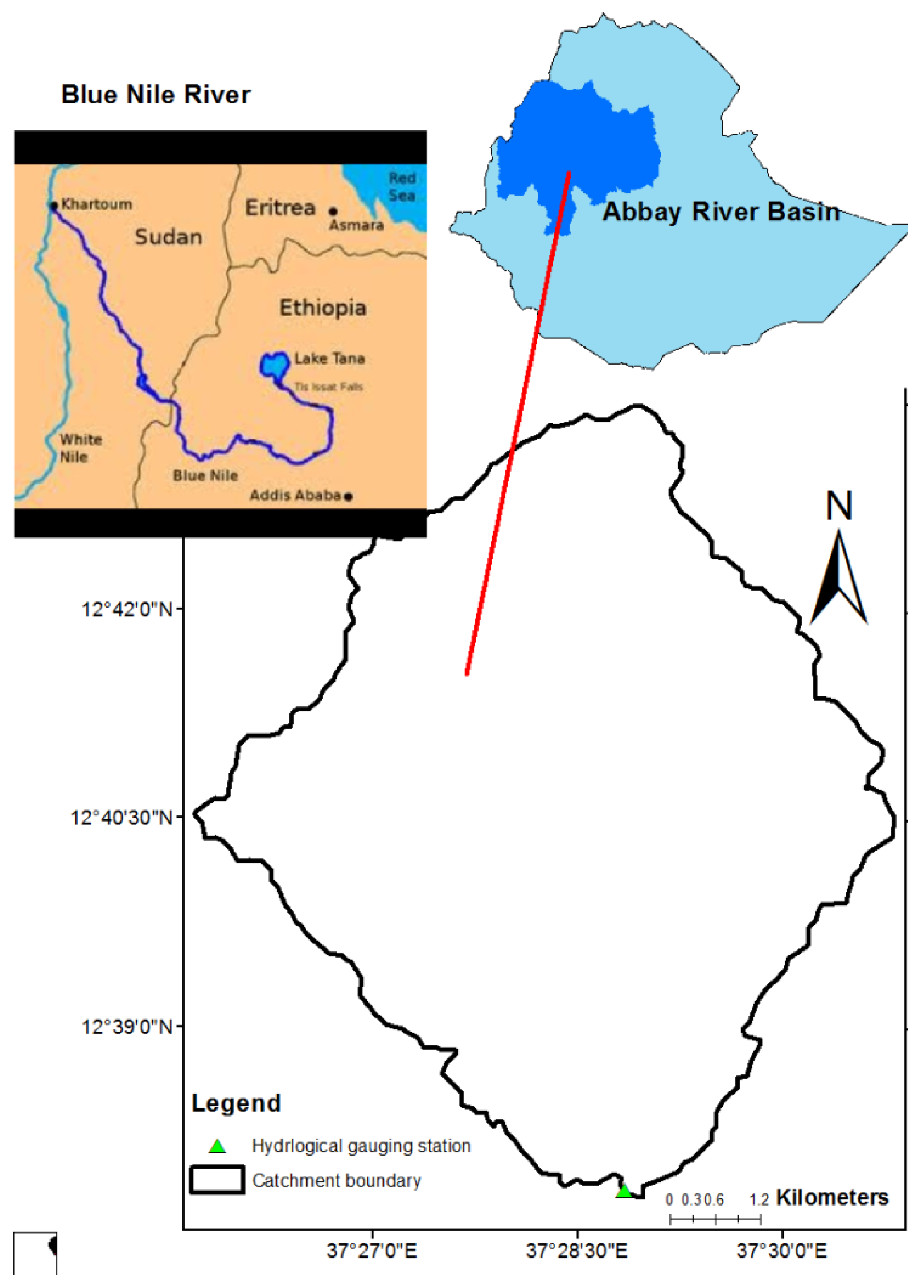
2.1. Description of Study Area
2.2. Data Collection
2.2.1. Rainfall Data
2.2.2. Discharge Data
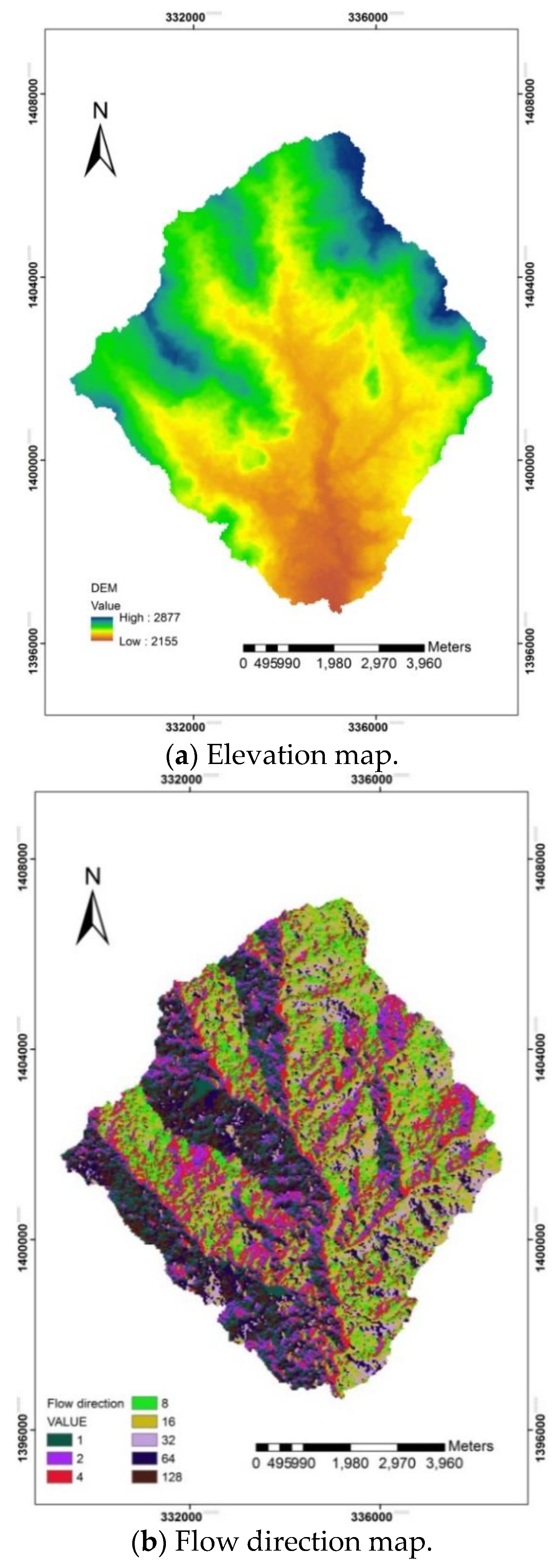
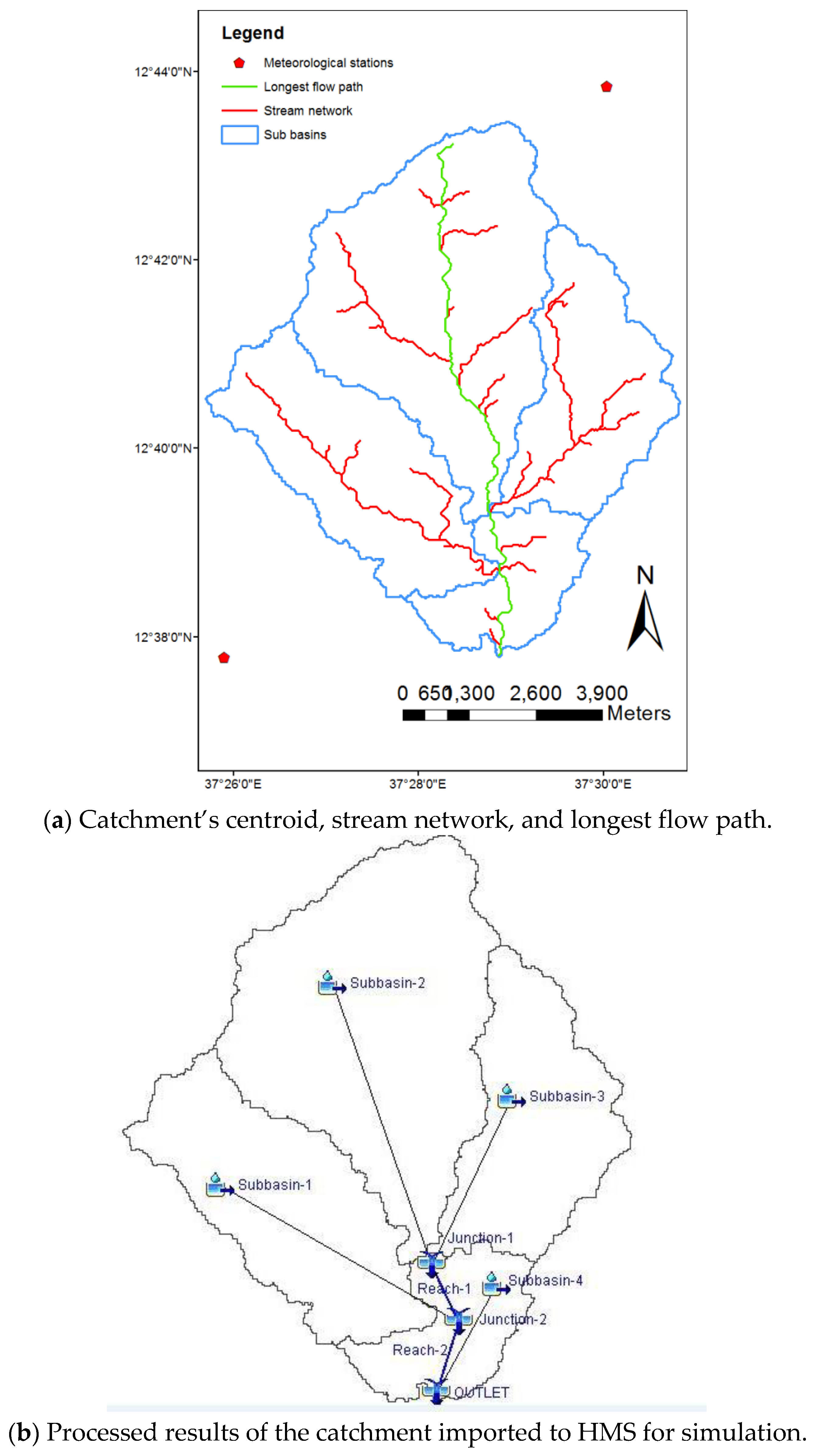
2.2.3. DEM Data Processing Using HEC-GeoHMS Tool in ArcGIS Programme
2.3. HEC-HMS Mode
2.3.1. Loss Methods
2.3.2. The Transform Method
2.3.3. A Base Flow Separation Method
2.3.4. Model Calibration and Validation
3. Results and Discussion
3.1. Physiographic Characteristics of the Catchment
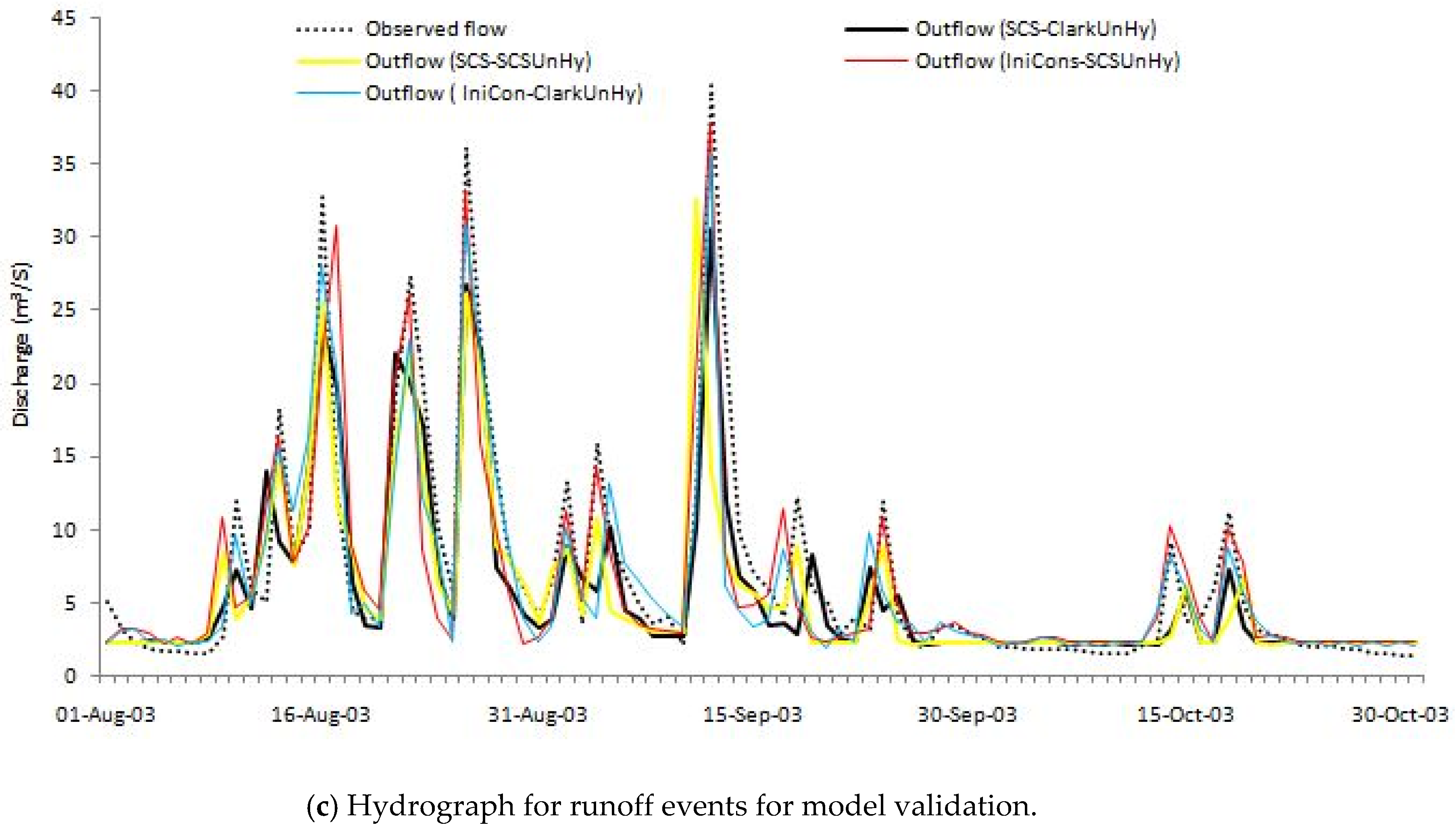
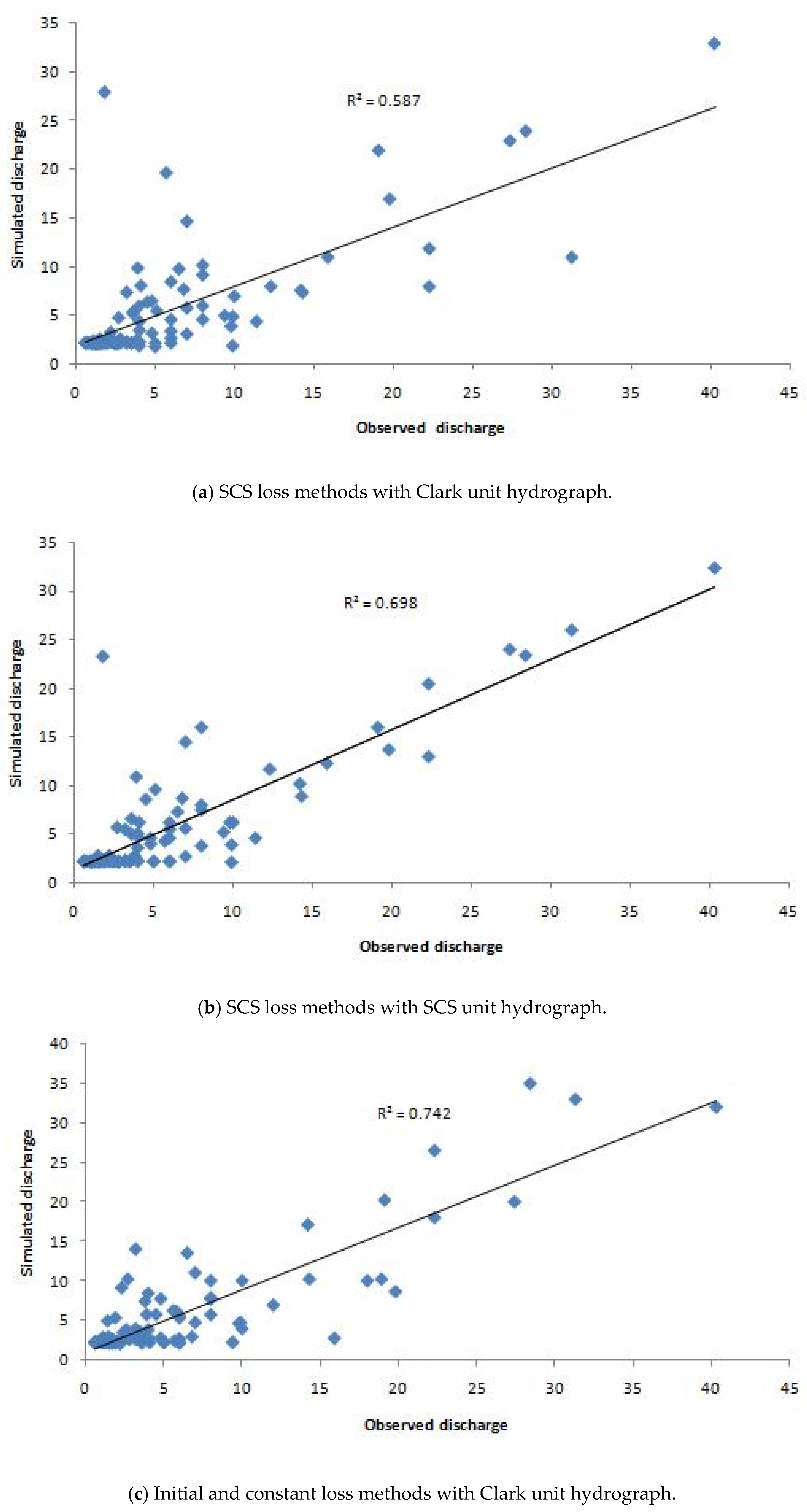
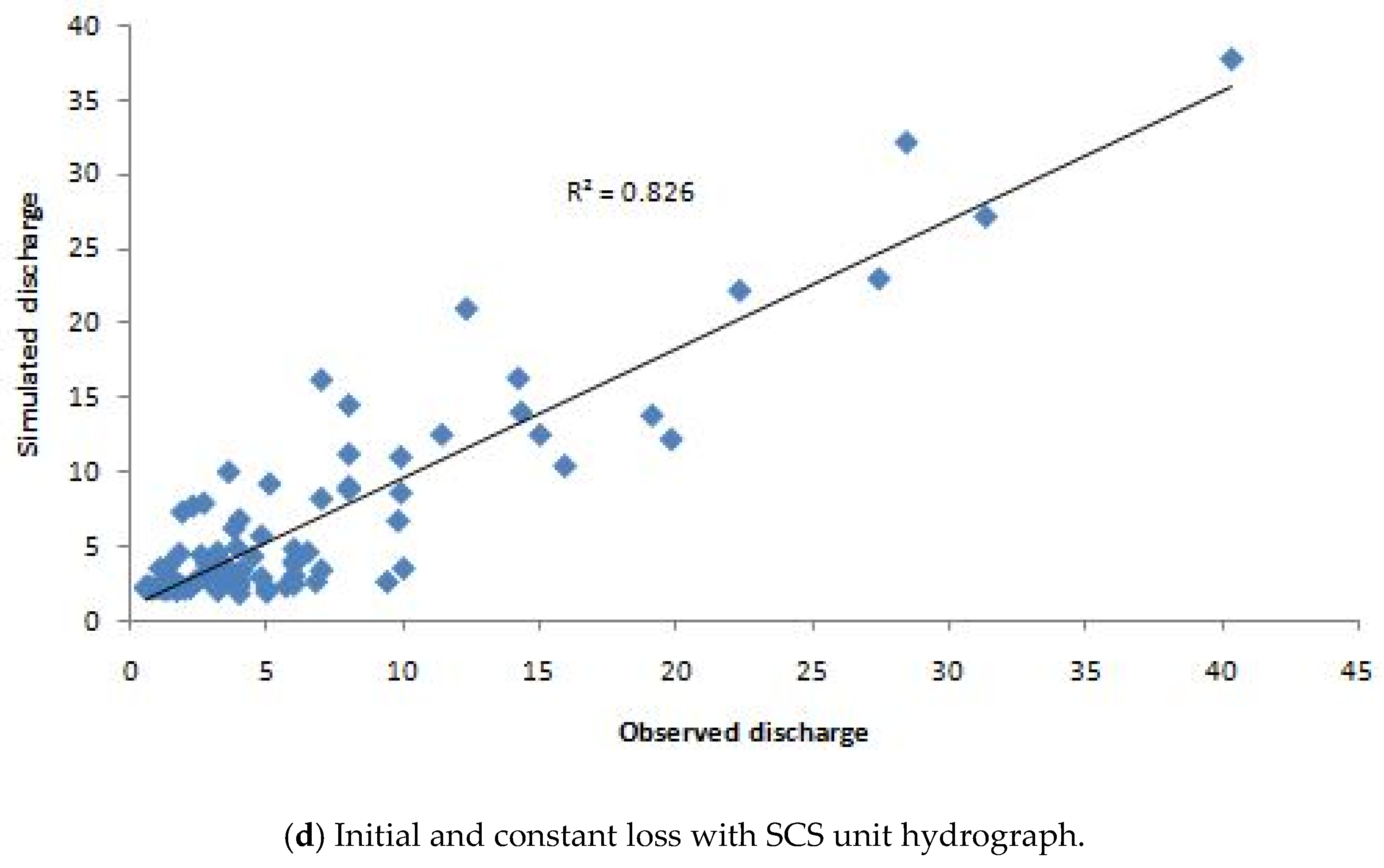
3.2. Simulation Results of The HEC-HMS Model
3.3. Discussion
4. Conclusions
Author Contributions
Funding
Acknowledgments
Conflicts of Interest
References
- Putty, M.R.Y.; Prasad, R. Understanding runoff processes using a watershed model: A case study in the Western Ghats in South India. J. Hydrol. 2000, 228, 215–227. [Google Scholar] [CrossRef]
- Oleyiblo, J.O.; Li, Z. Application of HEC-HMS for flood forecasting in Misai and Wan’an catchments in China. Water Sci. Eng. 2010, 3, 14–22. [Google Scholar] [CrossRef]
- Beven, K.J.; Kirkby, M.J. A physically based variable contributing area model of basin hydrology. Hydrol. Sci. Bull. 1979, 24, 43–69. [Google Scholar] [CrossRef]
- Zhao, W.W.; FU, B.J.; Meng, Q.H.; Zhang, Q.J.; Zhang, Y.H. Effects of land-use pattern change on rainfall-runoff and runoff-sediment relations: A case study in Zichang watershed of the Loess Plateau of China. J. Environ. Sci. 2004, 16, 436–442. [Google Scholar]
- Todini, E. The ARNO rainfall-runoff model. J. Hydrol. 1996, 175, 339–382. [Google Scholar] [CrossRef]
- Sugawara, M. Automatic calibration of the tank model. Hydrol. Sci. Bull. 1979, 24, 375–388. [Google Scholar] [CrossRef]
- Singh, V.P.; Woolhiser, D.A. Mathematical modelling of watershed hydrology. J. Hydrol. Eng. 2002, 7, 270–292. [Google Scholar] [CrossRef]
- Pilgrim, D.H.; Cordery, I. Flood runoff. In Handbook of Hydrology; McGraw-Hill Inc.: New York, NY, USA, 1993. [Google Scholar]
- Singh, V.P. Applied Modeling in Catchment Hydrology; Water Resources Publications: Littleton, CO, USA, 1982. [Google Scholar]
- Beven, K.J. Rainfall-Runoff Modelling: The Primer; John Wiley& Sons: Chichester, UK; Wiley-Blackwell: Hoboken, NJ, USA, 2012. [Google Scholar]
- Jin, X.; Xu, C.Y.; Zhang, Q.; Chen, Y.D. Regionalization study of a conceptual hydrological model in Dongjiang basin, south China. Quat. Int. 2009, 208, 129–137. [Google Scholar] [CrossRef]
- Majidi, A.; Shahedi, K. Simulation of Rainfall-Runoff Process Using Green-Ampt Method and HEC-HMS Model (Case Study: Abnama Watershed, Iran). Int. J. Hydraul. Eng. 2012, 1, 5–9. [Google Scholar] [CrossRef]
- Verma, A.K.; Jha, M.K.; Mahana, R.K. Evaluation of HEC-HMS and WEPP for simulating watershed runoff using remote sensing and geographical information system. Paddy Water Environ. 2010, 8, 131–144. [Google Scholar] [CrossRef]
- Hesbon, O.; Dawei, H. Comparative Study on Water Resources Assessment between Kenya and England. In Proceedings of the 11th International Conference on Hydroinformatics HIC, New York, NY, USA, 17–21 August 2014. [Google Scholar]
- Skhakhfa, I.D.; Ouerdachi, L. Hydrological modelling of wadiRessoul watershed, Algeria, by HECHMS model. J. Water Land Dev. 2016, 31, 139–147. [Google Scholar] [CrossRef]
- Feldman, A.D. Hydrologic Modeling System HEC-HMS. In Technical Reference Manual; U.S. Army Corps of Engineers, Hydrologic Engineering Center: Davis, CA, USA, 2000. [Google Scholar]
- U.S. Army Corps of Engineers. Hydrologic Modeling System (HEC-HMS) Applications Guide: Version 3.1.0; Hydrologic Engineers Center: Davis, CA, USA, 2008. [Google Scholar]
- Halwatura, D.; Najim, M.M. Application of the HEC-HMS model for runoff simulation in a tropical catchment. Environ. Model. Softw. 2013, 46, 155–162. [Google Scholar] [CrossRef]
- Kathol, J.P.; Werner, H.D.; Trooien, T.P. Runoff for Frequency Based Storm Using a Prediction- Runoff Model; ASAE: Washington, DC, USA, 2003. [Google Scholar]
- Knebl, M.; Yang, Z.; Hutchison, K.; Maidment, D.R. Regional scale flood modeling using NEXRAD rainfall, GIS, and HEC-HMS / HEC-RAS: A case study for the San Antonio River Basin Summer 2002 storm event. J. Environ. Manag. 2005, 75, 325–336. [Google Scholar] [CrossRef] [PubMed]
- McColl, C.; Aggett, G. Land use forecasting and hydrologic model integration for improved land use decision support. J. Environ. Manag. 2006, 84, 494–512. [Google Scholar] [CrossRef] [PubMed]
- Momcilo, M.; Angle, Y.L.; Hejazi, M. Changing estimates for design precipitation in northeastern Illinois. Comparison between different sources and sensitivity analysis. J. Hydrol. 2007, 347, 211–222. [Google Scholar]
- Amengual, A.; Romero, R.A. Hydrometeorological modeling study of a flash-flood event over Catalonia, Spain. J. Hydrol. 2007, 8, 282–303. [Google Scholar] [CrossRef]
- Yusop, Z.; Chan, C.H.; Katimon, A. Runoff characteristics and application of HEC-HMS for modelling storm flow hydrograph in an oil palm catchment. J. Water Sci. Technol. 2007, 56, 41–48. [Google Scholar] [CrossRef] [PubMed]
- Garcia, A.; Sainz, A.; Revilla, J.; Alvarez, C. Surface water resources assessment in scarcely gauged basins in the north of Spain. J. Hydrol. 2008, 356, 312–326. [Google Scholar] [CrossRef]
- Jin, H.; Liang, R.; Wang, Y.; Tumula, P. Flood-Runoff in Semi-Arid and Sub-Humid Regions, a Case Study: A Simulation of Jianghe Watershed in Northern China. Water 2015, 7, 5155–5172. [Google Scholar] [CrossRef]
- Arekhi, S.; Rostamizad, G.; Rostami, N. Evaluation of HEC-HMS Methods in Surface Runoff Simulation (Case Study: Kan Watershed, Iran). Adv. Environ. Biol. 2011, 5, 1316–1321. [Google Scholar]
- Haberlandt, U.; Radtke, I. Hydrological model calibration for derived flood frequency analysis. Hydrol. Earth Syst. Sci. 2014, 18, 353–365. [Google Scholar] [CrossRef]
- Gumindoga, W.; Makurira, H.; Phiri, M.; Nhapi, I. Estimating runoff from ungauged catchments for reservoir water balance in the Lower Middle Zambezi Basin. Water SA 2016, 42, 641–649. [Google Scholar] [CrossRef]
- Azam, M.; Kim, H.S.; Maeng, S.J. Development of flood alert application in Mushim stream watershed Korea. Int. J. Disaster Risk Reduct. 2017, 21, 11–26. [Google Scholar] [CrossRef]
- Yilma, H.; Moges, S.A. Application of semi-distributed conceptual hydrological model for flow forecasting on upland catchments of Blue Nile River Basin, a case study of Gilgel Abbay catchment. Catchment Lake Res. 2007, 6, 1–200. [Google Scholar]
- Merrey, D.J.; Gebreselassie, T. Promoting Improved Rainwater and Land Management in the Blue Nile (Abay) Basin of Ethiopia; NBDC Technical Report 1; International Livestock Research Institute: Nairobi, Kenya, 2011. [Google Scholar]
- Blöschl, G. Rainfall-runoff modeling of un-gauged catchments. Encycl. Hydrol. Sci. 2005, 5, 1–19. [Google Scholar] [CrossRef]
- Chow, V.; Maidment, D.; Mays, L. Applied Hydrology; McGraw-Hill Science/Engineering/Math: New York, NY, USA, 1998. [Google Scholar]
- Najim, M.M.; Babel, M.S.; Loof, R. AGNPS model assessment for a mixed forested watershed in Thailand. Sci. Asia 2006, 32, 53–61. [Google Scholar] [CrossRef]
- Nash, J.E.; Sutclife, J.V. River flow forecasting through conceptual models Part 1: A discussion of principles. J. Hydrol. 1970, 10, 282–290. [Google Scholar] [CrossRef]
- Neter, J.; Wasserman, W.; Kutner, M.H. Applied Linear Models: Regression, Analysis of Variance, and Experimental Designs, 3rd ed.; Irwin: Homewood, IL, USA, 1990. [Google Scholar]
- Sabzevari, T.; Ardakanian, R.; Shamsaee, A.; Talebi, A. Estimation of flood hydrograph in no statistical watersheds using HEC-HMS model and GIS (Case study: Kasilian watershed). J. Water Eng. 2009, 4, 1–11. [Google Scholar]
- Zou, K.H.; Tuncali, K.; Silverman, S.G. Correlation and simple linear regression. Radiology 2003, 227, 617–622. [Google Scholar] [CrossRef] [PubMed]
- Sharma, K.D. Modified runoff curve numbers for bare crust forming sandy soils. Aust. J. Soil Res. 1987, 25, 541–545. [Google Scholar] [CrossRef]
- Hawkins, R.H. Asymptotic determination of runoff curve numbers from data. J. Irrig. Drain. Eng. 1993, 119, 334–345. [Google Scholar] [CrossRef]
- Zelelew, D.G. Spatial mapping and testing the applicability of the curve number method for un-gauged catchments in Northern Ethiopia. Int. Soil Water Conserv. Res. 2017, 5, 293–301. [Google Scholar] [CrossRef]
- Burn, D.H.; Boorman, D.B. Estimation of hydrological parameters at un-gauged catchments. J. Hydrol. 1993, 143, 429–454. [Google Scholar] [CrossRef]


| Parameters | Values |
|---|---|
| Area | 55.2 km2 |
| Perimeter | 45,076 m |
| Max. Elevation | 2877 m |
| Min. Elevation | 2155 m |
| Mean slope of the basin | 25.6% |
| Main channel length | 12,485 m |
| Main channel mean slope | 2.81% |
| Drainage density | 0.94 km/km2 |
| Sub-Basins | Area (km2) | Perimeter (m) | Basin Slope (%) | Main River Flow | Curve Number | Constant Loss Rate (mm/h) | |||
|---|---|---|---|---|---|---|---|---|---|
| Flow Length (m) | Slope (m/m) | Initial Values | Optimized Values | Initial Values | Optimized Values | ||||
| Sub-basin 1 | 13.76 | 25,757 | 26.5 | 7877 | 0.045 | 78 | 86 | 3.8 | 2.2 |
| Sub-basin 2 | 24.08 | 31,018 | 26.2 | 9030 | 0.035 | 75 | 90 | 4.3 | 3.1 |
| Sub-basin 3 | 11.55 | 23,345 | 26.3 | 6424 | 0.051 | 72 | 82 | 6.7 | 4.4 |
| Sub-basin 4 | 5.77 | 17,776 | 19.8 | 3455 | 0.021 | 68 | 68 | 7.8 | 5.2 |
| Element | X | Muskinghum (K), K(h) | ||
|---|---|---|---|---|
| Initial Values | Optimized Values | Initial Values | Optimized Values | |
| Reach 1 | 0.2 | 0.145 | 1 | 0.65 |
| Reach 2 | 0.2 | 0.145 | 1 | 0.65 |
| Simulation Event | Observed Runoff Depth (mm) | Outflow (SCS-ClarkHy) | Change in % | Outflow (SCS-SCSHy) | Change in % | Outflow (InCo-SCSHy) | Change in % | Outflow (InCo-ClarkHy) | Change in % |
|---|---|---|---|---|---|---|---|---|---|
| Before calibration | 614.83 | 378.25 | −38.48 | 407.8 | −33.67 | 462.98 | −24.70 | 485.07 | −21.11 |
| For model calibration | 420.41 | 350.71 | −16.58 | 352.04 | −16.26 | 373.87 | −11.07 | 359.48 | −14.49 |
| For model validation | 975.92 | 801.58 | −17.92 | 798.32 | −18.20 | 910.13 | −6.74 | 877.00 | −10.14 |
| (a) Uncalibrated | |||||||||
| Date | Observed Flow (m3/s) | Outflow (SCS-ClarkUH) | Change in % | Outflow (SCS-SCSUH) | Change in % | Outflow (InCo-SCSUH) | Change in % | Outflow (InCo-ClarkUH) | Change in % |
| 8 September 1992 | 15.9 | 7.8 | −50.94 | 8.3 | −47.80 | 10.8 | −32.08 | 9.6 | −39.62 |
| 27 March 1993 | 8.1 | 3.8 | −53.09 | 4.3 | −46.91 | 5.6 | −30.86 | 6.6 | −18.52 |
| 12 July 1993 | 30.2 | 17.3 | −42.72 | 19.2 | −36.42 | 22.4 | −25.83 | 19.2 | −36.42 |
| 8 September 1994 | 32.9 | 13.1 | −60.18 | 17.2 | −47.72 | 24.2 | −26.44 | 22.5 | −31.61 |
| 9 May 1995 | 25.4 | 11.2 | −55.91 | 11.7 | −53.94 | 17.6 | −30.71 | 15.6 | −38.58 |
| 2 August 1995 | 18.4 | 11.5 | −37.5 | 10.4 | −43.48 | 12.1 | −34.23 | 10.0 | −45.65 |
| Average | −50.06 | −46.05 | −30.03 | −35.07 | |||||
| (b) Calibrated | |||||||||
| Date | Observed Flow (m3/s) | Outflow (SCS-ClarkHy) | Change in % | Outflow (SCS-SCSHy) | Change in % | Outflow (InCo-SCSHy) | Change in % | Outflow (InCo-ClarkHy) | Change in % |
| 12 July 1996 | 24.6 | 14.7 | −40.24 | 17.8 | −27.64 | 21.8 | −11.38 | 20.4 | −17.07 |
| 21 August 1996 | 20.4 | 16 | −21.57 | 15.6 | −23.53 | 18.2 | −10.78 | 18.2 | −10.78 |
| 16 August 2003 | 32.8 | 23.7 | −27.74 | 24.2 | −26.22 | 28.6 | −12.80 | 25.2 | −23.17 |
| 22 August 2003 | 27.4 | 20.7 | −24.45 | 22 | −19.71 | 24.3 | −11.31 | 20.9 | −23.72 |
| 26 August 2003 | 36.2 | 26.7 | −26.24 | 26.2 | −27.62 | 33.2 | −8.29 | 31.1 | −14.09 |
| 4 July 2004 | 35.2 | 24 | −31.82 | 27.8 | −21.02 | 31.8 | −9.66 | 29.8 | −15.34 |
| Average | −28.68 | −24.29 | −10.70 | −17.36 | |||||
| Statistical Evaluation Criteria | Loss Methods | |||
|---|---|---|---|---|
| SCS Loss Method | Initial and Constant Loss Method | |||
| SCS Unit Hydrograph | Clark Unit Hydrograph | SCS Unit Hydrograph | SCS Unit Hydrograph | |
| Relative bias errors (%) | 24.29 ns | 28.68 ns | 17.36 ** | 10.71 *** |
| Coefficient of determination (R2) | 0.70 * | 0.59 * | 0.74 ** | 0.83 *** |
| Nash-Sutcliffe Efficiency (%) | 64.7 * | 57.8 ns | 71.8 ** | 82.8 *** |
© 2018 by the authors. Licensee MDPI, Basel, Switzerland. This article is an open access article distributed under the terms and conditions of the Creative Commons Attribution (CC BY) license (http://creativecommons.org/licenses/by/4.0/).
Share and Cite
Zelelew, D.G.; Melesse, A.M. Applicability of a Spatially Semi-Distributed Hydrological Model for Watershed Scale Runoff Estimation in Northwest Ethiopia. Water 2018, 10, 923. https://doi.org/10.3390/w10070923
Zelelew DG, Melesse AM. Applicability of a Spatially Semi-Distributed Hydrological Model for Watershed Scale Runoff Estimation in Northwest Ethiopia. Water. 2018; 10(7):923. https://doi.org/10.3390/w10070923
Chicago/Turabian StyleZelelew, Demlie G., and Assefa M. Melesse. 2018. "Applicability of a Spatially Semi-Distributed Hydrological Model for Watershed Scale Runoff Estimation in Northwest Ethiopia" Water 10, no. 7: 923. https://doi.org/10.3390/w10070923
APA StyleZelelew, D. G., & Melesse, A. M. (2018). Applicability of a Spatially Semi-Distributed Hydrological Model for Watershed Scale Runoff Estimation in Northwest Ethiopia. Water, 10(7), 923. https://doi.org/10.3390/w10070923