Addressing Gaps in Environmental Water Policy Issues across Five Mediterranean Freshwater Protected Areas


Abstract
1. Introduction
2. Materials and Methods
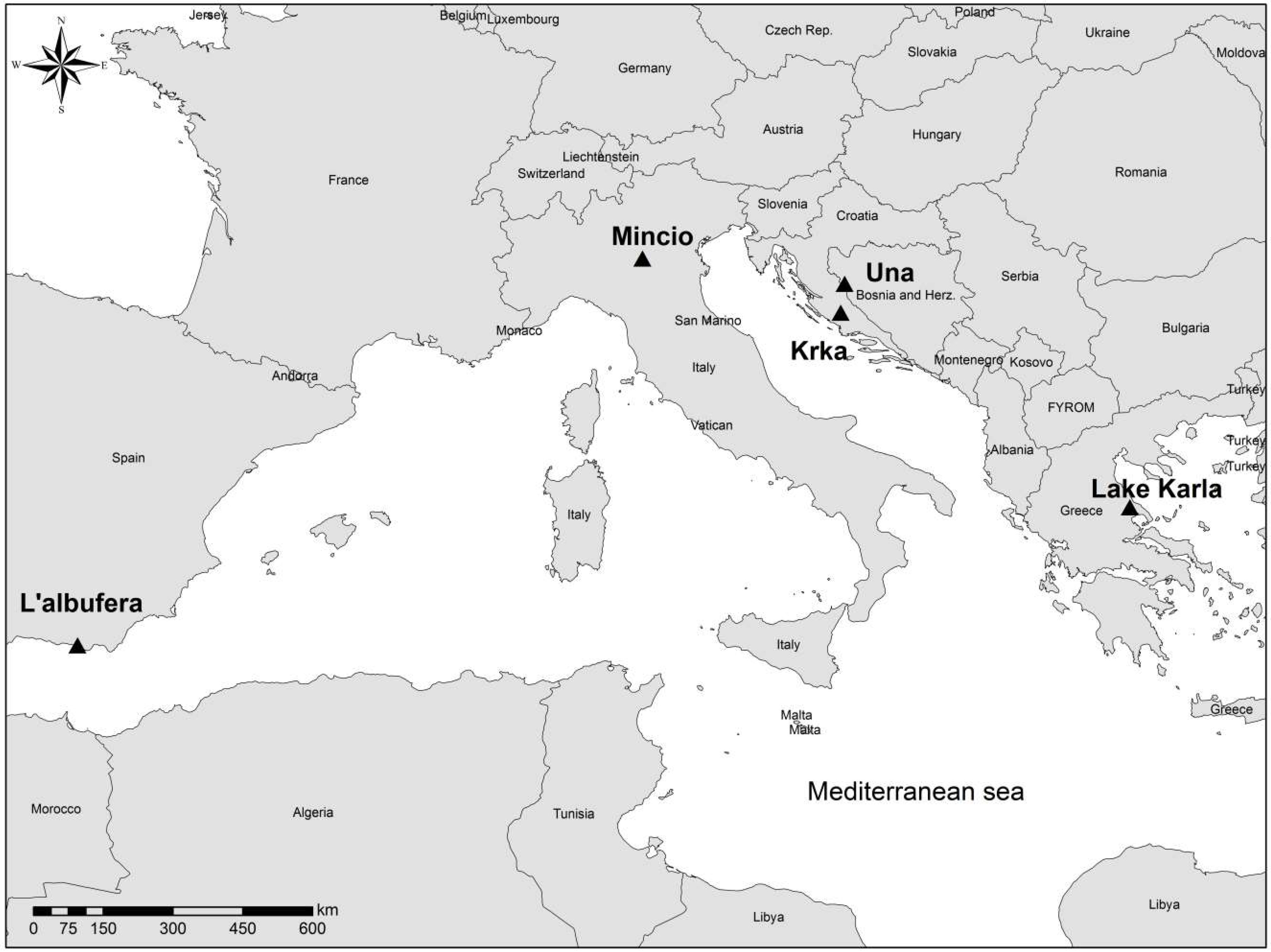
2.1. Description of the Study Areas
- Lake Albufera in L’ Albufera Natural Park—Valencia, Spain
- Lake Visovac in Krka National Park—Šibenik, Croatia
- Mantua Lakes in Mincio Regional Park—Mantova, Italy
- River Una in Una National Park—Bihać, Bosnia and Herzegovina
- Lake Karla in the Protected Area of Karla—Magnesia, Greece
2.2. The Conceptual Framework
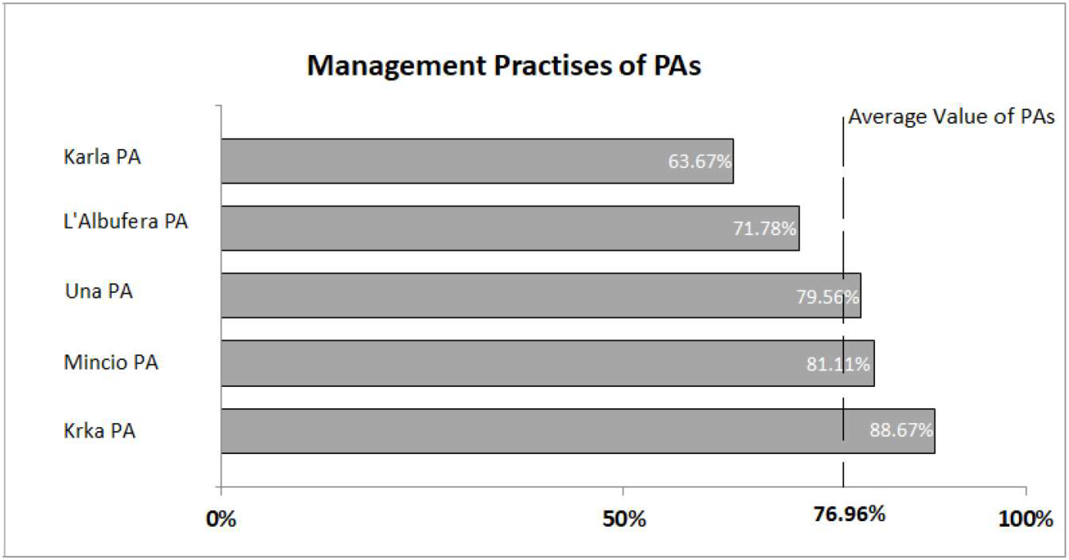
- Management Practices: the set of queries selected in this field is such that can produce a clear image regarding PA management structure and actions regarding to its effectiveness, the PA accessibility and relations with visitors along with other goods and comforts provided (Table A1).
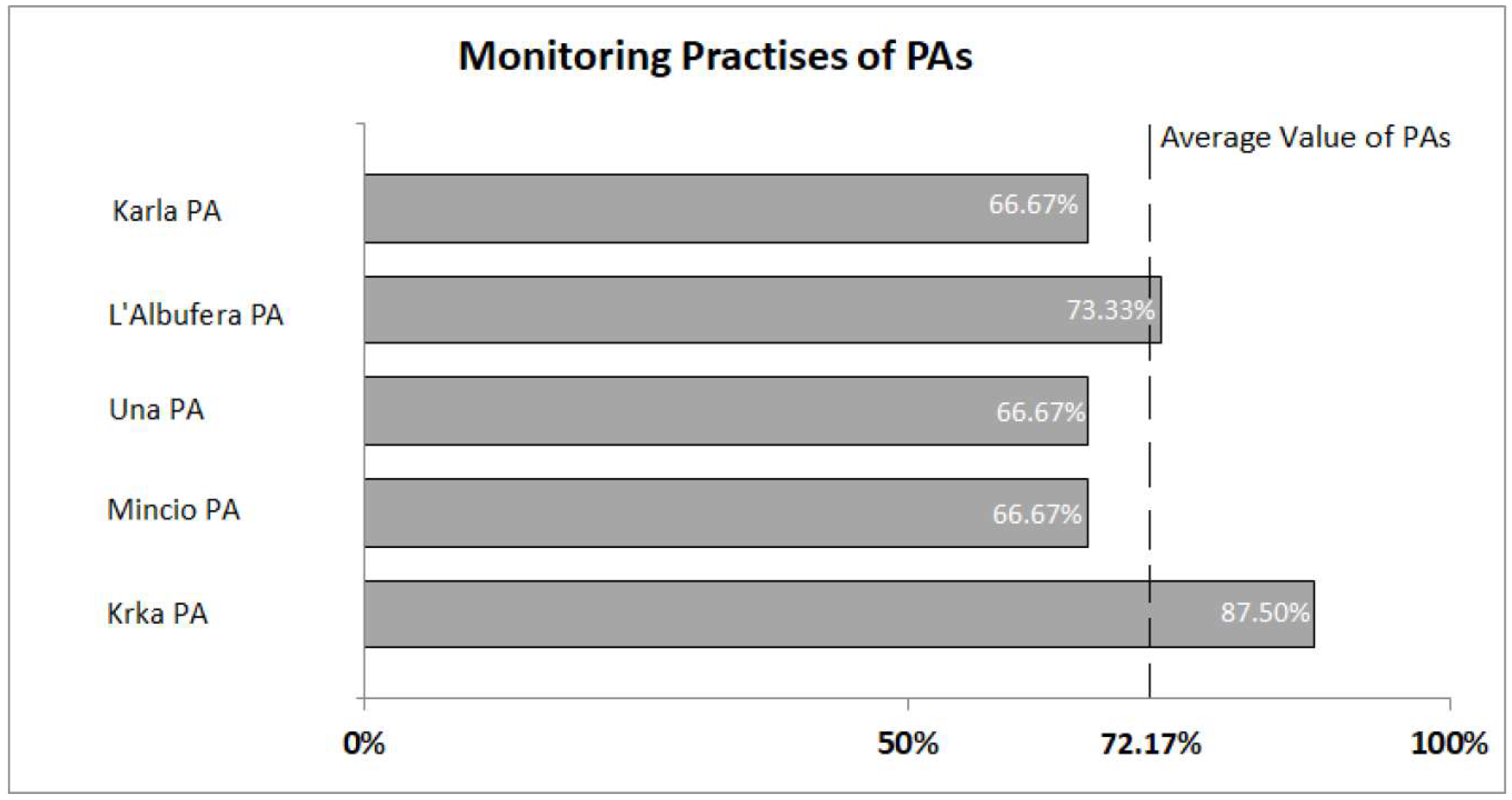
- Monitoring Practices: Parameters indicative of biological, hydromorphological and physical-chemical quality elements are required to be monitored within certain frequencies. Similar to the WFD, other EU directives (bathing, nitrates, habitats), comprising Europe’s water policy legislation, set the frame of requirements for monitoring on which regional and national institutions are supposed to base their monitoring programmes. In this field, several quality elements, their monitoring frequencies and special assessments are included (Table A2).
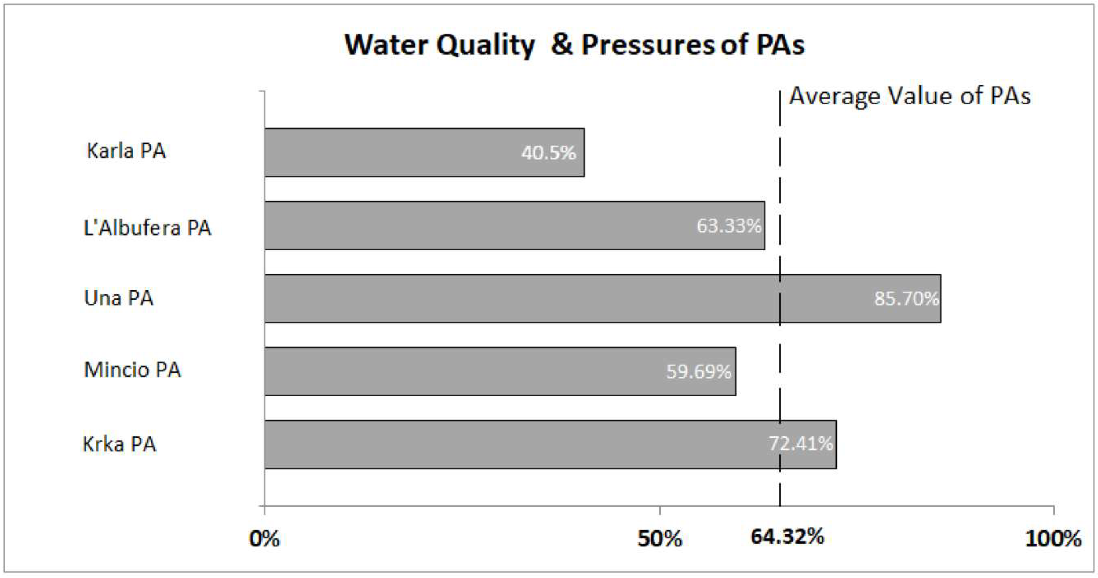
- Water Quality and Pressures: This criterion is addressed mostly as the knowledge availability, for the ability of comparing biological, physicochemical, ecological and other abiotic parameters with the limits of guidances and directives, and synthesizing the information required by broadly accepted indexes. Along with the aforementioned parameters, descriptive assessment of probable amelioration/deterioration on certain ecosystem values and services is evaluated (Table A3).
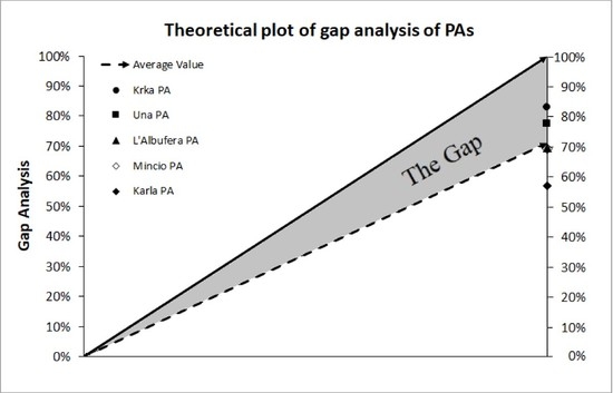
2.3. Gap Analysis Methodology
- First the identification of the objectives is set, meaning the desirable level (the 100% of the target value) which is different for each field. A final selection of 15 queries was considered as enough to reflect the preferable status in all three fields. An equal number of queries is selected for the comparability of the results.
- Second comes the analysis of the current situation. The current situation is quantified based on: PA’s responsible MB on the three-set query matrix along with a dataset of recently (2016, 2017) monitored elements for the waterbodies provided by each PA Management Authority enriched with a database formed by raw data, gathered during an extended literature review.
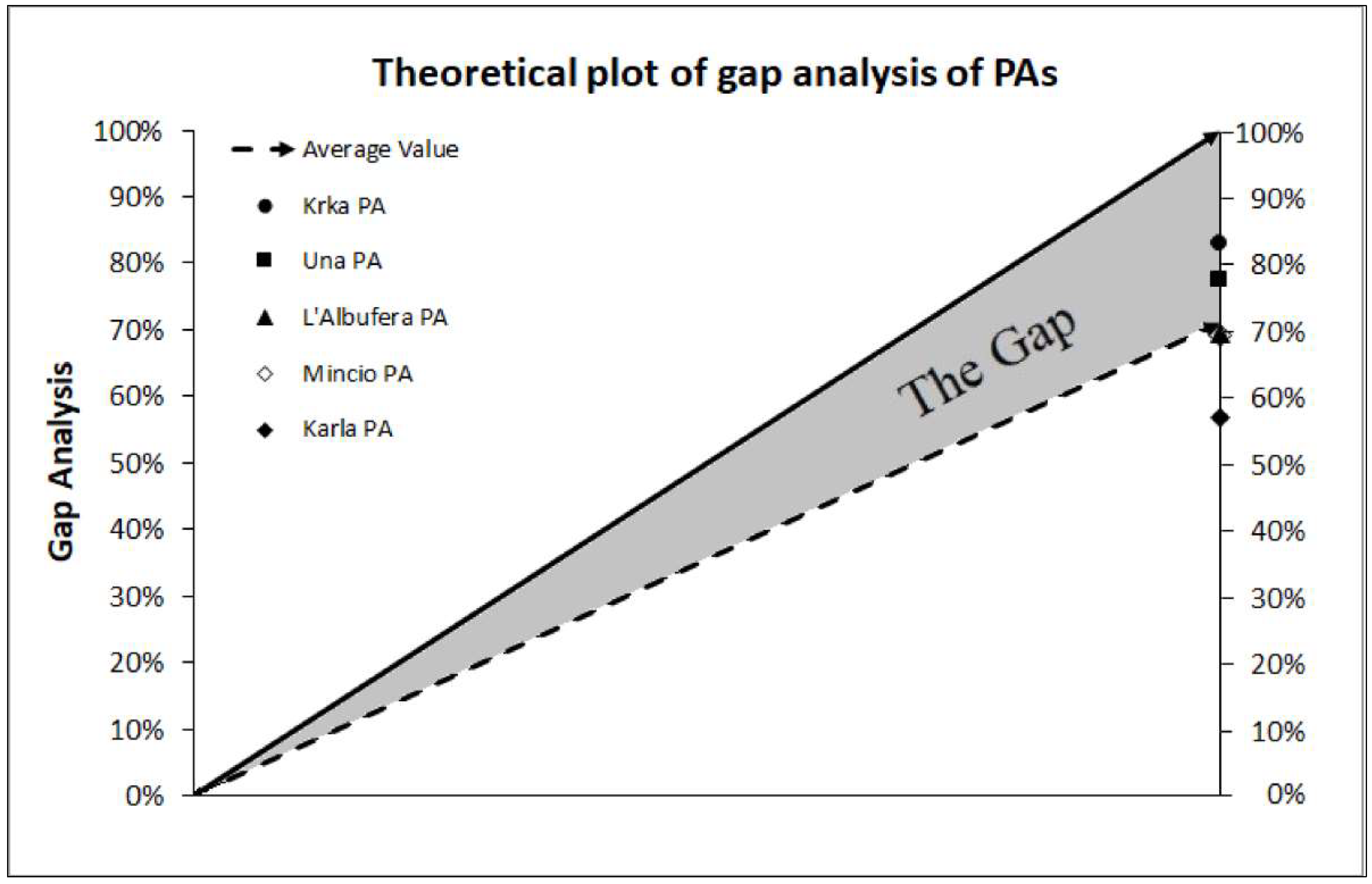
- The third step is gap assessment. The gap stems from the difference between current and desired level; namely the percentage of indices measured, along with their values of the ideal situation. These percentages come from the replies of the queries as follows: when the reply is yes or no, the percentage results in only two options, 0% or 100%, but when the reply has more options, a classification of percentages is raised, according to the number of classes. When descriptive assessment is applicable in queries, replies stating amelioration are graded positively, those stating deterioration are graded negatively and those stating stability with half the full grade. More details on the grading of each query is presented in Appendix.
- In order to visualize the gap, simple mathematics are applied. The cumulative average statistics are used to assess the final results of every PA for the examined fields. A comprehensive presentation is performed regarding the derived percentage value for each query of the three thematic categories. Each one of these queries is equally important for the analysis, so, no weight coefficients are used. The same mathematic formula applies for the final value that characterizes each MB of PA and each category. This final value is the average of the gap of all three categories.
3. Results
4. Discussion
5. Conclusions
Author Contributions
Funding
Acknowledgments
Conflicts of Interest
Appendix A

| Query No | Possible Responses and Grading (in%) of the Target Value | ||||
|---|---|---|---|---|---|
| 1 | Environment (25%) | Biodiversity (25%) | Tourism (25%) | Research (25%) | |
| 2 | Surveillance (33.3%) | Environmental Awareness (33.3%) | Monitoring (33.3%) | ||
| 3 | Yes (100%) | No (0%) | |||
| 4 | National/Municipal (25%) | Own/Private (25%) | LIFE (25%) | Interreg 2014–2020/European Regional Development Fund (ERDF) /Horizon 2020 (25%) | |
| 5 | Yes (100%) | No (0%) | |||
| 6 | The value 100% refers to the MB with the maximum number of staff of this fraction per area. 25% for the MB with less staff | ||||
| 7 | Environment (20%) | Biodiversity (20%) | Surveillance (20%) | Tourism (20%) | Οthers (20%) |
| 8 | Yes (100%) | No (0%) | |||
| 9 | Yes (100%) | No (0%) | |||
| 10 | Yes (50%) | Yes with Contract (100%) | No (0%) | ||
| 11 | Yes open (50%) | Yes with Kiosks (100%) | No (0%) | ||
| 12 | Yes (100%) | No (0%) | |||
| 13 | Yes (100%) | No (0%) | |||
| 14 | Yes (100%) | No (0%) | |||
| 15 | Yes (100%) | No (0%) | |||
| Query No | Possible Responses and Grading (in%) of the Target Value | |||||
|---|---|---|---|---|---|---|
| 1 | Yes (100%) | No (0%) | ||||
| 2 | Yes (100%) | No (0%) | ||||
| 3 | Yes (100%) | No (0%) | ||||
| 4 | Yes (100%) | No (0%) | ||||
| 5 | Yes (100%) | No (0%) | ||||
| 6 | Yes (100%) | No (0%) | ||||
| 7 | Yes (100%) | No (0%) | ||||
| 8 | Yes (100%) | No (0%) | ||||
| 9 | Yes (100%) | No (0%) | ||||
| Every month | Every 3 months | Every 6 months | Every year | More than 1 year | Never | |
| 10 | 100 | 100 | 100 | 100 | 50 | 0 |
| 11 | 100 | 100 | 100 | 100 | 50 | 0 |
| 12 | 100 | 100 | 50 | 0 | 0 | 0 |
| 13 | 100 | 50 | 0 | 0 | 0 | 0 |
| 14 | 100 | 50 | 0 | 0 | 0 | 0 |
| 15 | 100 | 100 | 50 | 0 | 0 | 0 |
| Query No | Possible Responses and Grading (in %) of the Target Value | ||||
|---|---|---|---|---|---|
| Don’t know | Negative | Positive | None | ||
| 1 | 0 | 0 | 100 | 50 | |
| 2 | 0 | 0 | 100 | 50 | |
| 3 | 0 | 0 | 100 | 50 | |
| 4 | 0 | 0 | 100 | 50 | |
| 5 | 0 | 0 | 100 | 50 | |
| Affect little | Affect | Main source of contamination | Don’t know | ||
| 6 | 75 | 25 | 0 | 0 | |
| 7 | 75 | 25 | 0 | 0 | |
| 8 | 75 | 25 | 0 | 0 | |
| 9 | 75 | 25 | 0 | 0 | |
| 10 | 75 | 25 | 0 | 0 | |
| 11 | Total N (20%) | Total P (20%) | Chl-a (20%) | Turbidity (20%) | Secchi depth-Transparency (20%) |
| 12 | Metals (25%) | Agrochemicals (25%) | Pesticides (25%) | Priority Subsances (25%) | |
| 13 | Zn and Cu, CaCO3 (hardness), Total Suspended Solids (TSS), Biochemical Oxygen Demand (BOD), pH, NH4, NH3, NO2, Temperature, Dissolved Oxygen (DO), Phenols, HOCl and Total P all take 8% if there are any recent recorded values | ||||
| 14 | Mycrocystin (MCYST) (25%) | Cyanoacterial biovolume (25%) | Chl-a (25%) | Leptospira/Amoeba/Feacal coliforms (25%) | |
| 15 | Conductivity, Alkalinity, Salinity, Total Dissolved Solids (TDS), Dissolved Organic Material (DOM), Oxidation/Reduction Potential or redox Potential (ORP), Phycocyanin and others photosynthetic pigments all take 13% if there are recent recorded values | ||||
References
- Paavola, J.; Gouldson, A.; Kluvánková-Oravská, T. Interplay of actors, scales, frameworks and regimes in the governance of biodiversity. Environ. Policy Gov. 2009, 19, 148–158. [Google Scholar] [CrossRef]
- Rauschmayer, F.; Berghöfer, A.; Omann, I.; Zikos, D. Examining processes or/and outcomes? Evaluation concepts in european governance of natural resources. Environ. Policy Gov. 2009, 19, 159–173. [Google Scholar] [CrossRef]
- Vikolainen, V.; De Bruijn, T.; Bressers, H. Improving environmental policy enforcement. Environ. Eng. Manag. J. 2013, 12, 1637–1643. [Google Scholar]
- Dudley, N.; Harrison, J.I.; Kettunen, M.; Madgwick, J.; Mauerhofer, V. Natural solutions for water management of the future: Freshwater protected areas at the 6th World Parks Congress. Aquat. Conserv. 2016, 26 (Suppl. 1), 121–132. [Google Scholar] [CrossRef]
- Juffe-Bignoli, D.; Burgess, N.D.; Bingham, H.; Belle, E.M.S.; De Lima, M.G.; Deguignet, M.; Bertzky, B.; Milam, A.N.; Martinez-Lopez, J.; Lewis, E.; et al. Protected Planet Report 2014; UNEP-WCMC: Cambridge, UK, 2014; pp. 1–80. ISBN 978-92-807-3416-4. [Google Scholar]
- Pittock, J.; Finlayson, M.; Arthington, A.H.; Roux, D.; Matthews, J.H.; Biggs, H.; Harrison, I.; Blom, E.; Flitcroft, R.; Froend, R.; et al. Chapter 19, Managing freshwater, river, wetland and estuarine protected areas. In Protected Area Governance and Management; Worboys, G.L., Lockwood, M., Kothari, A., Feary, S., Pulsford, I., Eds.; ANU Press: Canberra, Australia, 2015; pp. 569–608. [Google Scholar]
- Vollmer, D.; Shaad, K.; Souter, J.N.; Farrell, T.; Dudgeon, D.; Sullivan, A.C.; Fauconnier, I. Integrating the social, hydrological and ecological dimensions of freshwater health: The Freshwater Health Index. Sci. Total Environ. 2018, 627, 304–313. [Google Scholar] [CrossRef] [PubMed]
- Abellan, P.; Sanchez-Fernandez, D.; Velasco, J.; Millan, A. Effectiveness of protected area networks in representing freshwater biodiversity: The case of a Mediterranean river basin (south-eastern Spain). Aquat. Conserv. Mar. Freshw. Ecosyst. 2007, 17, 361–374. [Google Scholar] [CrossRef]
- Darwall, W.; Carrizo, S.; Numa, C.; Barrios, V.; Freyhof, J.; Smith, K. Freshwater Key Biodiversity Areas in the Mediterranean Basin Hotspot: Informing Species Conservation and Development Planning in Freshwater Ecosystems; IUCN: Cambridge, UK; Malaga, Spain, 2014; p. 86. ISBN 978-2-8317-1698-5. [Google Scholar]
- Kanakoudis, V.; Tsitsifli, S. On-Going evaluation of the WFD 2000/60/EC implementation process in the European Union, seven years after its launch: Are we behind schedule? Water Policy 2010, 12, 70–91. [Google Scholar] [CrossRef]
- Demetropoulou, L.; Nikolaidis, N.; Papadoulakis, V.; Tsakiris, K.; Koussouris, T.; Kalogerakis, N.; Koukaras, K.; Chatzinikolaou, A.; Theodoropoulos, K. Water framework directive implementation In Greece: Introducing participation in water governance—the Case of the Evrotas River Basin management plan. Environ. Policy Gov. 2010, 20, 336–349. [Google Scholar] [CrossRef]
- Kati, V.; Hovardas, T.; Dieterich, M.; Ibisch, L.P.; Mihok, B.; Selva, N. The challenge of implementing the European network of protected areas Natura 2000. Conserv. Biol. 2014, 29, 260–270. [Google Scholar] [CrossRef]
- Voulvoulis, N.; Arpon, D.K.; Giakoumis, T. The EU Water Framework Directive: From Great Expectations to Problems with Implementation. Sci. Total Environ. 2017, 575, 358–366. [Google Scholar] [CrossRef]
- Maia, R. The WFD Implementation in the European Member States. Water Resour. Manag. 2017, 31, 3043–3060. [Google Scholar] [CrossRef]
- Young, C.J.; Butler, R.A.J.; Jordan, A.; Watt, D.A. Less government intervention in biodiversity management: Risks and opportunities. Biodivers. Conserv. 2012, 21, 1095–1100. [Google Scholar] [CrossRef]
- Hauck, J.; Schweppe-Kraft, B.; Albert, C.; Görg, C.; Jax, K.; Jensen, R.; Fürst, C.; Maes, J.; Ring, I.; Hönigová, I.; et al. The promise of the ecosystem services concept for planning and decision-making. GAIA 2013, 22, 232–236. [Google Scholar] [CrossRef]
- Hauck, J.; Albert, C.; Fürst, C.; Geneletti, G.; La Rosa, D.; Lorz, C.; Spyra, M. Developing and applying ecosystem service indicators in decision-support at various scales. Ecol. Indic. 2016, 61, 1–5. [Google Scholar] [CrossRef]
- Harrington, R.; Anton, C.; Dawson, P.T.; De Bello, F.; Feld, K.C.; Haslett, R.J.; Kluvánkova-Oravská, T.; Kontogianni, A.; Lavorel, S.; Luck, W.G.; et al. Ecosystem services and biodiversity conservation: Concepts and a glossary. Biodivers. Conserv. 2010, 19, 2773–2790. [Google Scholar] [CrossRef]
- World Health Organization. Available online: www.who.int/influenza/pip/pip_pc_ga.pdf (accessed on 1 June 2017).
- Unicef. Available online: https://www.unicef.org/jamaica/gapanalysis_finalreport_sep2016.pdf (accessed on 15 June 2017).
- IUCN—International Union for Conservation of Nature. Available online: https://cmsdata.iucn.org/downloads/pag_015.pdf (accessed on 12 May 2017).
- Rodrigues, S.L.A.; Akçakaya, R.H.; Andelman, J.S.; Bakarr, I.M.; Boitani, L.; Brooks, M.T.; Chanson, S.J.; Fishpool, D.C.L.; Da Fonseca, A.B.G.; Gaston, J.K.; et al. Global Gap Analysis: Priority Regions for Expanding the Global Protected-Area Network. BIOSENCE 2004, 54, 1092–1100. [Google Scholar] [CrossRef]
- Arino, H.R.; Chavan, V.; Otegui, J. Best Practice Guide for Data Gap Analysis for Biodiversity Stakeholders; GBIF Secretariat: Copenhagen, Denmark, 2016; pp. 1–41. [Google Scholar]
- Hunter, M.L.; Yonzon, P. Altitudinal Distributions of Birds, Mammals, People, Forests, and Parks in Nepal. Conserv. Biol. 1993, 7, 420–423. [Google Scholar] [CrossRef]
- Fearnside, P.M.; Ferraz, J. A Conservation Gap Analysis of Brazil’s Amazonian Vegetation. Conserv. Biol. 1995, 9, 1134–1147. [Google Scholar] [CrossRef]
- Scott, J.M.; Davis, W.F.; McGhie, G.R.; Gerald Wright, R.; Groves, C.; Estes, J. Nature Reserves: Do they capture the full range of America’s biological diversity? Ecol. Appl. 2001, 11, 999–1007. [Google Scholar] [CrossRef]
- Jennings, D.M. Gap analysis: Concepts, methods, and recent results. Landsc. Ecol. 2000, 15, 5–20. [Google Scholar] [CrossRef]
- Sharafi, M.S.; Moilanen, A.; White, M.; Burgman, M. Integrating environmental gap analysis with spatial conservation prioritization: A case study from Victoria, Australia. J. Environ. Manag. 2012, 112, 240–251. [Google Scholar] [CrossRef] [PubMed]
- Strittholt, R.J.; Boerner, E.J.R. Applying Biodiversity Gap Analysis in a Regional Nature Reserve Design for the Edge of Appalachia, Ohio (U.S.A.). Conserv. Biol. 1995, 9, 1492–1505. [Google Scholar] [CrossRef]
- Fairbanks, D.H.K.; Benn, G.A. Identifying regional landscapes for conservation planning: A case study from KwaZulu-Natal, South Africa. Landsc. Urban Plan. 2000, 50, 1–19. [Google Scholar] [CrossRef]
- Han, S.; Koo, D.D.; Kim, Y.; Kim, S.; Park, J. Gap Analysis Based Decision Support Methodology to Improve Level of Service of Water Services. Sustainability 2017, 9, 1578. [Google Scholar] [CrossRef]
- Burley, F.W. Monitoring biological diversity for setting priorities in conservation. In Biodiversity; Wilson, E.O., Peter, F.M., Eds.; National Academy Press: Washington, DC, USA, 1988; pp. 227–230. [Google Scholar]
- Scott, J.M.; Davis, F.; Csuti, B.; Noss, R.; Butterfield, B.; Groves, C.; Anderson, H.; Caicco, S.; D’ Erchia, F.; Edwards, C.T.; et al. Gerald Weight R. Gap Analysis: A Geographic Approach to Protection of Biological Diversity. Wildl. Monogr. 1993, 123, 3–41. [Google Scholar]
- Channon, D.F.; Sammut-Bonnici, T. Gap analysis. In Wiley Encyclopedia of Management, 3rd ed.; Cooper, C.L., Ed.; John Wiley & Sons: Hoboken, NJ, USA, 2014; Volume 12, pp. 1–2. ISBN 9781118785317. [Google Scholar]
- Dimarchopoulou, D.; Stergiou, I.K.; Tsikliras, C.A. Gap analysis on the biology of Mediterranean marine fishes. PLoS ONE 2017, 12, e0175949. [Google Scholar] [CrossRef]
- Latinopoulos, D.; Sidiropoulos, P.; Kagalou, I. Gap Analysis targeting WFD monitoring and pressure mapping: Lessons learned from “EcoSUSTAIN”, Interreg-MED Project. In Proceedings of the 3rd EWaS International Conference on “Insights on the Water-Energy-Food Nexus, Lefkada, Greece, 27–30 June 2018. [Google Scholar]
- Field, A.S.; O’ Connor, J.P.; Tyre, J.A.; Possingham, P.G. Making monitoring meaningful. Austral. Ecol. 2007, 32, 485–491. [Google Scholar] [CrossRef]
- Hasan, M. The Gap Analysis—Methodology; Lesson Notes; Institute of Governance Studies, BRAC University: Dhaka, Bengal, 2010. [Google Scholar]
- Del Barrio Fernández, P.; García Gómez, A.; García Alba, J.; Álvarez Díaz, C.; Revilla Cortezón, A.J. A model for describing the eutrophication in a heavily regulated coastal lagoon. Application to the Albufera of Valencia (Spain). J. Environ. Manag. 2012, 112, 340–352. [Google Scholar] [CrossRef]
- Rodrigo, A.M.; García, A.; Chivas, A.R. Carbon stable isotope composition of charophyte organic matter in a small and shallow Spanish water body as a baseline for future trophic studies. J. Limnol. 2016, 75, 226–235. [Google Scholar] [CrossRef]
- Kralj, K.; Plenković-Moraj, A.; Gligora, M.; Primc-Habdija, B.; Šipoš, L. Structure of Periphytic Community on Artificial Substrata: Influence of Depth, Slide Orientation and Colonization Time in Karstic Lake Visovačko, Croatia. Hydrobiologia 2006, 560, 249–258. [Google Scholar] [CrossRef]
- Svensen, C.; Viličić, D.; Wassmann, P.; Arashkevich, E.; Ratkova, T. Plankton distribution and vertical flux of biogenic matter during high summer stratification in the Krka estuary (Eastern Adriatic). Estuar. Coast. Shelf Sci. 2007, 71, 381–390. [Google Scholar] [CrossRef]
- Ravazzi, C.; Marchetti, M.; Zanon, M.; Perego, R.; Quirino, T.; Deaddis, M.; De Amicis, M.; Margaritora, D. Lake evolution and landscape history in the lower Mincio River valley, unravelling drainage changes in the central Po Plain (N-Italy) since the Bronze Age. Quat. Int. 2013, 288, 195–205. [Google Scholar] [CrossRef]
- Pinardi, M.; Rossetto, M.; Viaroli, P.; Bartoli, M. Daily and seasonal variability of CO2 saturation and evasion in a free flowing and in a dammed river reach. J. Limnol. 2014, 73, 468–481. [Google Scholar] [CrossRef]
- Korjenić, A.; Misilo, M. Morphological characteristics of the Una-Sana Canton relief as spatial planning factor. Geogr. Rev. 2016, 37, 197–208. [Google Scholar]
- Sidiropoulos, P.; Papadimitriou, T.; Stabouli, Z.; Loukas, A.; Mylopoulos, N.; Kagalou, I. Past, present and future concepts for conservation of the re-constructed lake Karla (Thessaly-Greece). Fresen. Environ. Bull. 2012, 21. [Google Scholar] [CrossRef]
- Sidiropoulos, P.; Chamoglou, M.; Kagalou, I. Evaluating the ecological restoration of a Mediterranean reservoir. Eur. Water 2017, 58, 209–215. [Google Scholar]
- Hermoso, V.; Abell, R.; Linke, S.; Boon, P. The role of protected areas for freshwater biodiversity conservation: Challenges and opportunities in a rapidly changing world. Aquat. Conserv. 2016, 26, 3–11. [Google Scholar] [CrossRef]
- Meyer, C.; Thiel, A. Institutional change in water management collaboration: Implementing the European Water Framework Directive in the German Odra river basin. Water Policy 2012, 14, 625–646. [Google Scholar] [CrossRef]
- Kanakoudis, V.; Tsitsifli, S.; Azariadi, T. Overview of the River Basin Management Plans developed in Greece under the context of the Water Framework Directive 2000/60/EC focusing at the economic analysis. Water Resour. Manag. 2015, 29, 3149–3174. [Google Scholar] [CrossRef]
- Galbiati, L.; Zaldivar, J.M.; Somma, F.; Bouraoui, F.; Moren-Abat, M.C.; Bidoglio, G.; D’Eugenio, J. Pilot River Basin Outcome Report: Testing of the WFD Guidance Documents; Joint Research Centre and the Directorate General Environment of the European Commission: Luxembourg, 2005; pp. 1–104. ISBN 92-894-8980-4. [Google Scholar]
- Kanakoudis, V.; Tsitsifli, S. River basin management plans developed in Greece based on the WFD 2000/60/EC guidelines. Desalin. Water Treat. 2015, 56, 1231–1239. [Google Scholar] [CrossRef]
- Kampa, E.; Bressers, H. Evolution of the Greek national regime for water resources. Water Policy 2008, 10, 481. [Google Scholar] [CrossRef]
- Directorate-General for Environment. Staff Working Document: The EU Environmental Implementation Review, Country Report—GREECE. Accompanying the document: The EU Environmental Implementation Review: Common Challenges and How to Combine Efforts to Deliver Better Results; European Commission: Brussels, Belgium, 2008; pp. 1–25. [Google Scholar]
- Wagner, I.; Zalewski, M. Ecohydrology as a basis for the sustainable city strategic planning: Focus on Lodz, Poland. Rev. Environ. Sci. Biol. 2009, 8, 209–217. [Google Scholar] [CrossRef]
- McClain, M.E.; Chícharo, L.; Fohrer, N.; Gaviño Novillo, M.; Windhorst, W.; Zalewski, M. Training hydrologists to be ecohydrologists and play a leading role in environmental problem solving. Hydrol. Earth Syst. Sci. 2012, 16, 1685–1696. [Google Scholar] [CrossRef]
- Hernández-Crespo, C.; Martín, M. Determination of background levels and pollution assessment for seven metals (Cd, Cu, Ni, Pb, Zn, Fe, Mn) in sediments of a Mediterranean coastal lagoon. Catena 2015, 133, 206–214. [Google Scholar] [CrossRef]
- Romo, S.; Fernández, F.; Ouahid, Y.; Barón-Sola, Á. Assessment of microcystins in lake water and fish (Mugilidae, Liza sp.) in the largest Spanish coastal lake. Environ. Monit. Assess 2012, 184, 939–949. [Google Scholar] [CrossRef] [PubMed]
- Young, C.J.; Jordan, A.; Searle, R.K.; Butler, A.; Chapman, S.D.; Simmons, P.; Watt, D.A. Does stakeholder involvement really benefit biodiversity conservation? Biol. Conserv. 2013, 158, 359–370. [Google Scholar] [CrossRef]
- Ramin, M.; Cheng, Y.S.V.; Kim, D.K.; Ni, J.F.; Javed, A.; Kelly, E.N.; Yang, C.; Midlane-Jones, S.; Mugalingam, S.; Arhonditsis, B.G. An Integrative Methodological Framework for Setting Environmental Criteria: Evaluation of Public Preferences. Ecol. Econ. 2018, 147, 298–311. [Google Scholar] [CrossRef]
- Ménard, C.; Jimenez, A.; Tropp, H. Addressing the policy-implementation gaps in water services: The key role of meso-institutions. Water Int. 2017, 43, 13–33. [Google Scholar] [CrossRef]
- Courrau, J.; Dudley, N.; Hockings, M.; Leverinhton, F.; Stolton, S. Evaluating Effectiveness: A framework for Assessing Management Effectiveness of Protected Areas, 2nd ed.; IUCN: Gland, Switzerland, 2006; pp. 1–121. ISBN 2-8317-0939-3. [Google Scholar]
- Borrini, G.; Dudley, N.; Jaeger, T.; Lassen, B.; Pathak, N.; Phillips, A.; Sandwith, T. Governance of Protected Areas : From Understanding to Action; IUCN: Gland, Switzerland, 2013; pp. 1–144. ISBN 978-2-8317-1608-4. [Google Scholar]
- Oldfield, E.E.T.; Smith, J.R.; Harrop, R.S.; Leader-Williams, N. A gap analysis of terrestrial protected areas in England and its implications for conservation policy. Biol. Conserv. 2004, 120, 303–309. [Google Scholar] [CrossRef]
- White, P.A. Economic drivers of land use and groundwater use by irrigators, Waimea Plains Nelson, New Zealand. New Zeal. J. Mar. Fresh 2011, 45, 513–524. [Google Scholar] [CrossRef]


| Management Practices Queries | 1 | 2 | 3 | 4 | 5 |
|---|---|---|---|---|---|
| Operation under Legal and administrative frameworks (Environment, Biodiversity, Tourism, Research) | 75% | 100% | 75% | 100% | 50% |
| Main actions (Surveillance, Environmental Awareness, Monitoring) | 67% | 100% | 67% | 33% | 100% |
| Public involvement actions and stakeholder meetings | 100% | 100% | 100% | 100% | 100% |
| Different Sources of income | 50% | 50% | 25% | 75% | 50% |
| Volunteer Involvement | 100% | 100% | 100% | 100% | 100% |
| No of employees per ha of PA’s Management Body (MB) 1 | 25% | 100% | 100% | 75% | 25% |
| Departments (Environment, Biodiversity, Surveillance, Tourism, Other) | 60% | 80% | 100% | 60% | 80% |
| Employees training & education | 100% | 100% | 100% | 100% | 100% |
| Application of best practices in Management plan | 100% | 100% | 100% | 100% | 0% |
| Involvement of other Bodies/Stakeholders for management plan application | 100% | 100% | 50% | 50% | 50% |
| PA open to visitors and existence of information points | 100% | 100% | 100% | 100% | 100% |
| Organized fieldtrips or rides | 100% | 100% | 100% | 100% | 100% |
| Ecological norms or ISO standards | 0% | 0% | 0% | 0% | 0% |
| Posters stating basic behavioral standards for tourists | 100% | 100% | 100% | 100% | 100% |
| Waste and recycling disposal places within PAs | 0% | 100% | 100% | 100% | 0% |
| Monitoring Practices Queries | 1 | 2 | 3 | 4 | 5 |
|---|---|---|---|---|---|
| Water Monitoring | 0% | 100% | 100% | 100% | 100% |
| Biodiversity Monitoring | 100% | 100% | 100% | 100% | 100% |
| Water body identified according to Common Implementation Strategy Guidance (CIS) for Water Framework Directive (WFD) | 0% | 100% | 100% | 0% | 100% |
| Water body subject to a monitoring protocol | 100% | 100% | 100% | 100% | 100% |
| Monitoring involves chemical water quality | 100% | 100% | 100% | 100% | 100% |
| Monitoring involves biological water quality | 100% | 100% | 100% | 100% | 100% |
| Monitoring involves hydromorphological modification assessment | 0% | 100% | 0% | 0% | 0% |
| Impact assessment | 100% | 100% | 0% | 100% | 0% |
| Ecological services assessment | 0% | 100% | 0% | 100% | 0% |
| Frequency for hydromorphological modification monitoring | 100% | 50% | 0% | 100% | 0% |
| Frequency for hydrological parameters monitoring | 100% | 100% | 100% | 100% | 100% |
| Frequency for nutrient parameters monitoring | 100% | 100% | 100% | 50% | 100% |
| Frequency for chemical and abiotic parameters monitoring | 100% | 100% | 50% | 0% | 100% |
| Frequency for indirect algal biomass monitoring | 100% | 100% | 50% | 50% | 50% |
| Frequency for biological parameters | 100% | 50% | 100% | 0% | 50% |
| Water Quality and Pressures Queries | 1 | 2 | 3 | 4 | 5 |
|---|---|---|---|---|---|
| Observed changes in water quality | 100% | 50% | 50% | 100% | 0% |
| Observed changes in lake habitats | 100% | 50% | 50% | - | 0% |
| Observed changes in river habitats | - | 50% | 50% | 100% | 50% |
| Observed changes in conservation activities | 100% | 100% | 0% | 100% | 50% |
| Observed changes in birds’ presence | 100% | 50% | 50% | 100% | 100% |
| Sewage treatment plants influence in area | 0% | 100% | 50% | 100% | 100% |
| Agrochemicals influence in area | 0% | 100% | 50% | 100% | 0% |
| Organic waste influence in area | 0% | 100% | 50% | 100% | 0% |
| Discharges influence in area | 0% | 0% | 50% | 100% | 0% |
| Uncontrolled residues accumulation influence in area | 50% | 50% | 50% | 100% | 0% |
| Carlson Trophic State Index | 100% | 100% | 100% | 80% | 100% |
| 2008/105/EC—Priority Substances Directive | 100% | 75% | 75% | 50% | 25% |
| 2006/44/EC—Fish-Life Directive | 100% | 92.3% | 84.4% | 76.9% | 100% |
| WHO Standards on recreational waters | 100% | 75% | 100% | 50% | 25% |
| Other basic optional physicochemical parameters | 100% | 71.4% | 85.7% | 42.9% | 57.1% |
© 2018 by the authors. Licensee MDPI, Basel, Switzerland. This article is an open access article distributed under the terms and conditions of the Creative Commons Attribution (CC BY) license (http://creativecommons.org/licenses/by/4.0/).
Share and Cite
Latinopoulos, D.; Sidiropoulos, P.; Kagalou, I. Addressing Gaps in Environmental Water Policy Issues across Five Mediterranean Freshwater Protected Areas. Water 2018, 10, 1853. https://doi.org/10.3390/w10121853
Latinopoulos D, Sidiropoulos P, Kagalou I. Addressing Gaps in Environmental Water Policy Issues across Five Mediterranean Freshwater Protected Areas. Water. 2018; 10(12):1853. https://doi.org/10.3390/w10121853
Chicago/Turabian StyleLatinopoulos, Dionissis, Pantelis Sidiropoulos, and Ifigenia Kagalou. 2018. "Addressing Gaps in Environmental Water Policy Issues across Five Mediterranean Freshwater Protected Areas" Water 10, no. 12: 1853. https://doi.org/10.3390/w10121853
APA StyleLatinopoulos, D., Sidiropoulos, P., & Kagalou, I. (2018). Addressing Gaps in Environmental Water Policy Issues across Five Mediterranean Freshwater Protected Areas. Water, 10(12), 1853. https://doi.org/10.3390/w10121853